Bridge Statistics for Fridley, Minnesota (MN)
Condition, Traffic, Stress, Structural Evaluation, Project Costs
- National Bridge Inventory (NBI) Statistics
- 22Number of bridges
- 279ft / 85.5mTotal length
- 1,373,104Total average daily traffic
- 88,478Total average daily truck traffic
- National Bridge Inventory (NBI) Registered Bridges for Fridley
- No street view available for this location
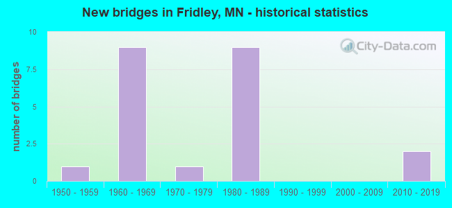
- New bridges - historical statistics
- 11950-1959
- 91960-1969
- 11970-1979
- 91980-1989
- 22010-2019


- Bridge Condition - Deck
- 63.6%Good
- 36.4%Satisfactory

- Bridge Condition - Superstructure
- 9.1%Very good
- 27.3%Good
- 63.6%Satisfactory

- Bridge Condition - Substructure
- 36.4%Good
- 45.5%Satisfactory
- 18.2%Fair

- Bridge Condition - Channel
- 33.3%Satisfactory
- 66.7%Fair

- Bridge Condition - Culverts
- 50.0%Good
- 50.0%Satisfactory
Find on map >> Show street view
Structure Number: 2523, Location: 0.2 MI NE OF JCT CSAH 1 (Lat: 45.045692, Lng: -93.273133), Route carried "on" structure: County highway 2, Year Built: 1973, Status: Open, Structure Length: 35.34m (115.94ft), Average Daily Traffic: 6,480 (year 2016), Truck Traffic: 6%, Average Future Daily Traffic: 6,480 (year 2034), Design Load: HS 20, Features Intersected: BNSF RR
Minimum Vertical Clearance: 30+ m (98+ ft), Kilometerpoint: 0.000, Lanes on structure: 2, Owner: County Highway Agency, Approaching Roadway Width: 13.4m (44.0ft), Material/Design: Steel continuous, Design/Construction: Stringer/Multi-beam, Number Of Spans In Main Unit: 8, Length of Maximum Span: 62.5m (205.1ft), Curb or Sidewalk Widths: Left: 0.0m, Right: 1.7m (5.6ft), Curb-To-Curb Width: 13.4m (44.0ft), Out-to-Out Width: 16.2m (53.1ft)
Condition: Deck: Good, Superstructure: Satisfactory, Substructure: Satisfactory, Operating Rating: 71.2 metric tons, Method Used To Determine Operating Rating: Load Factor (LF), Inventory Rating: 39.5 metric tons, Method Used To Determine Inventory Rating: Load Factor (LF), Structural Evaluation: Equal to present minimum criteria, Deck Geometry: Equal to present minimum criteria, Underclear: Meets minimum limits, Approach Roadway Alignment: Somewhat better than minimum adequacy, Designated Inspection Frequency: Every 24 months, Inspection Date: September 2020, Deck Structure Type: Concrete Cast-file-Place, Wearing Surface/Protective System: Wearing Surface: Low Slump Concrete
Find on map >> Show street view
Structure Number: 2541, Location: 1.5 MI N OF JCT TH 694 (Lat: 45.089972, Lng: -93.276139), Route carried "on" structure: County highway 1, Year Built: 1988, Status: Open, Structure Length: 1.71m (5.61ft), Average Daily Traffic: 13,912 (year 2016), Truck Traffic: 7%, Average Future Daily Traffic: 13,912 (year 2034), Design Load: HS 20, Features Intersected: RICE CREEK
Minimum Vertical Clearance: 30+ m (98+ ft), Kilometerpoint: 0.000, Lanes on structure: 4, Owner: County Highway Agency, Approaching Roadway Width: 25.6m (84.0ft), Skew: 21 degrees, Material/Design: Prestressed concrete, Design/Construction: Stringer/Multi-beam, Number Of Spans In Main Unit: 1, Length of Maximum Span: 15.5m (50.9ft), Curb or Sidewalk Widths: Left: 1.8m (5.9ft), Right: 1.8m (5.9ft), Curb-To-Curb Width: 20.7m (67.9ft), Out-to-Out Width: 30.1m (98.8ft)
Condition: Deck: Good, Superstructure: Good, Substructure: Good, Channel: Fair, Operating Rating: 49.6 metric tons, Method Used To Determine Operating Rating: Load Factor (LF), Inventory Rating: 29.8 metric tons, Method Used To Determine Inventory Rating: Load Factor (LF), Structural Evaluation: Better than present minimum criteria, Deck Geometry: Superior to present desirable criteria, Waterway Adequacy: Superior to present desirable criteria, Approach Roadway Alignment: Better than present minimum criteria, Designated Inspection Frequency: Every 24 months, Inspection Date: September 2021, Deck Structure Type: Concrete Cast-file-Place, Wearing Surface/Protective System: Wearing Surface: Low Slump Concrete, Deck Protection: Epoxy Coated Reinforcing
Find on map >> Show street view
Structure Number: 2587, Location: 0.2 MI W OF JCT TH 47 (Lat: 45.068761, Lng: -93.268325), Route carried "on" structure: , Year Built: 2017, Status: Open, Structure Length: 6.16m (20.21ft), Features Intersected: I 694, Facility Carried by Structure: PEDESTRIAN
Lanes under structure: 8, Owner: County Highway Agency, Material/Design: Steel, Design/Construction: Truss - Thru, Number Of Spans In Main Unit: 1, Length of Maximum Span: 60.6m (198.8ft), Out-to-Out Width: 3.7m (12.1ft)
Condition: Deck: Good, Superstructure: Very good, Substructure: Good, Underclear: High priority of corrective action, Bridge Posting: Required (Relationship of Operating Rating to Maximum Legal Load: > 39.9% below), Designated Inspection Frequency: Every 24 months, Inspection Date: October 2020, Deck Structure Type: Concrete Cast-file-Place, Wearing Surface/Protective System: Deck Protection: Epoxy Coated Reinforcing
Find on map >> Show street view
Structure Number: 2807, Location: 0.4 MI W OF JCT TH 47 (Lat: 45.068858, Lng: -93.271644), Route carried "on" structure: , Year Built: 1987, Status: Open, Structure Length: 5.43m (17.81ft), Features Intersected: I 694, Facility Carried by Structure: RAILROAD
Lanes under structure: 8, Owner: Railroad, Material/Design: Steel, Design/Construction: Girder and Floorbeam System, Number Of Spans In Main Unit: 2, Length of Maximum Span: 26.4m (86.6ft), Out-to-Out Width: 34.1m (111.9ft)
Condition: Deck: Good, Superstructure: Good, Substructure: Satisfactory, Underclear: Somewhat better than minimum adequacy, Bridge Posting: Required (Relationship of Operating Rating to Maximum Legal Load: > 39.9% below), Designated Inspection Frequency: Every 24 months, Inspection Date: July 2021, Wearing Surface/Protective System: Deck Protection: Epoxy Coated Reinforcing
Find on map >> Show street view
Structure Number: 2811, Location: 0.4 MI E OF JCT TH 47 (Lat: 45.068550, Lng: -93.257814), Route carried "on" structure: Interstate 694, Year Built: 1988, Status: Open, Structure Length: 2.77m (9.09ft), Average Daily Traffic: 141,000 (year 2019), Truck Traffic: 8%, Average Future Daily Traffic: 141,000 (year 2039), Design Load: HS 25 or greater, Features Intersected: 7th St. NE
Minimum Vertical Clearance: 30+ m (98+ ft), Kilometerpoint: 0.000, Lanes on structure: 8, Lanes under structure: 2, Base Highway Network: Yes, Owner: State Highway Agency, Approaching Roadway Width: 44.5m (146.0ft), Skew: 30 degrees, Material/Design: Prestressed concrete, Design/Construction: Stringer/Multi-beam, Number Of Spans In Main Unit: 1, Length of Maximum Span: 26.2m (86.0ft), Curb-To-Curb Width: 43.9m (144.0ft), Out-to-Out Width: 45.5m (149.3ft)
Condition: Deck: Good, Superstructure: Good, Substructure: Satisfactory, Operating Rating: 82.0 metric tons, Method Used To Determine Operating Rating: Load Factor (LF), Inventory Rating: 42.0 metric tons, Method Used To Determine Inventory Rating: Load Factor (LF), Structural Evaluation: Equal to present minimum criteria, Deck Geometry: Superior to present desirable criteria, Underclear: Better than present minimum criteria, Approach Roadway Alignment: Equal to present desirable criteria, Designated Inspection Frequency: Every 24 months, Inspection Date: July 2021, Deck Structure Type: Concrete Cast-file-Place, Wearing Surface/Protective System: Wearing Surface: Low Slump Concrete, Deck Protection: Epoxy Coated Reinforcing
Find on map >> Show street view
Structure Number: 2813, Location: AT THE JCT TH 47 (Lat: 45.068744, Lng: -93.263336), Route carried "on" structure: Interstate 694, Year Built: 1988, Status: Open, Structure Length: 4.76m (15.62ft), Average Daily Traffic: 141,000 (year 2019), Truck Traffic: 8%, Average Future Daily Traffic: 141,000 (year 2039), Design Load: HS 20, Features Intersected: MN 47
Minimum Vertical Clearance: 30+ m (98+ ft), Kilometerpoint: 0.000, Lanes on structure: 8, Lanes under structure: 4, Base Highway Network: Yes, Owner: State Highway Agency, Approaching Roadway Width: 38.1m (125.0ft), Skew: 30 degrees, Material/Design: Prestressed concrete, Design/Construction: Stringer/Multi-beam, Number Of Spans In Main Unit: 2, Length of Maximum Span: 23.1m (75.8ft), Curb-To-Curb Width: 36.6m (120.1ft), Out-to-Out Width: 38.2m (125.3ft)
Condition: Deck: Good, Superstructure: Satisfactory, Substructure: Satisfactory, Operating Rating: 75.1 metric tons, Method Used To Determine Operating Rating: Load Factor (LF), Inventory Rating: 29.6 metric tons, Method Used To Determine Inventory Rating: Load Factor (LF), Structural Evaluation: Equal to present minimum criteria, Deck Geometry: Better than present minimum criteria, Underclear: Somewhat better than minimum adequacy, Approach Roadway Alignment: Equal to present desirable criteria, Designated Inspection Frequency: Every 24 months, Inspection Date: July 2021, Deck Structure Type: Concrete Cast-file-Place, Wearing Surface/Protective System: Wearing Surface: Low Slump Concrete, Deck Protection: Epoxy Coated Reinforcing
Find on map >> Show street view
Structure Number: 2815, Location: AT THE JCT TH 65 (Lat: 45.067783, Lng: -93.247742), Route carried "on" structure: Interstate 694, Year Built: 1988, Status: Open, Structure Length: 6.19m (20.31ft), Average Daily Traffic: 125,000 (year 2019), Truck Traffic: 7%, Average Future Daily Traffic: 126,000 (year 2039), Design Load: HS 20, Features Intersected: MN 65
Minimum Vertical Clearance: 30+ m (98+ ft), Kilometerpoint: 0.000, Lanes on structure: 8, Lanes under structure: 4, Base Highway Network: Yes, Owner: State Highway Agency, Approaching Roadway Width: 42.1m (138.1ft), Skew: 31 degrees, Material/Design: Prestressed concrete, Design/Construction: Stringer/Multi-beam, Number Of Spans In Main Unit: 2, Length of Maximum Span: 31.2m (102.4ft), Curb-To-Curb Width: 41.5m (136.2ft), Out-to-Out Width: 43.1m (141.4ft)
Condition: Deck: Satisfactory, Superstructure: Satisfactory, Substructure: Fair, Operating Rating: 60.4 metric tons, Method Used To Determine Operating Rating: Load Factor (LF), Inventory Rating: 37.6 metric tons, Method Used To Determine Inventory Rating: Load Factor (LF), Structural Evaluation: Somewhat better than minimum adequacy, Deck Geometry: Superior to present desirable criteria, Underclear: Equal to present minimum criteria, Approach Roadway Alignment: Equal to present desirable criteria, Designated Inspection Frequency: Every 24 months, Inspection Date: July 2021, Deck Structure Type: Concrete Cast-file-Place, Wearing Surface/Protective System: Wearing Surface: Low Slump Concrete, Deck Protection: Epoxy Coated Reinforcing
Find on map >> Show street view
Structure Number: 8787, Location: 1.8 Mi North of Jct TH 6 (Lat: 45.093728, Lng: -93.243531), Route carried "on" structure: State highway 65, Year Built: 1953, Status: Open, Structure Length: 0.82m (2.69ft), Average Daily Traffic: 31,132 (year 2019), Truck Traffic: 3%, Average Future Daily Traffic: 30,500 (year 2039), Design Load: H 20, Features Intersected: RICE CREEK
Minimum Vertical Clearance: 30+ m (98+ ft), Kilometerpoint: 0.000, Lanes on structure: 4, Base Highway Network: Yes, Owner: State Highway Agency, Approaching Roadway Width: 37.2m (122.0ft), Skew: 10 degrees, Material/Design: Concrete, Design/Construction: Culvert, Number Of Spans In Main Unit: 2, Length of Maximum Span: 3.8m (12.5ft)
Condition: Channel: Satisfactory, Culverts: Satisfactory, Operating Rating: 39.2 metric tons, Method Used To Determine Operating Rating: Assigned ratings based on Allowable Stress Design (ASD) reported in metric tons, Inventory Rating: 29.4 metric tons, Method Used To Determine Inventory Rating: Assigned ratings based on Allowable Stress Design (ASD) reported in metric tons, Structural Evaluation: Equal to present minimum criteria, Waterway Adequacy: Equal to present desirable criteria, Approach Roadway Alignment: Equal to present desirable criteria, Designated Inspection Frequency: Every 24 months, Underwater Inspection Frequency: Every 60 months, Inspection Date: October 2020, Underwater Inspection Date: May 2021
Find on map >> Show street view
Structure Number: 91097, Location: 1.4 MI N OF TH 694 (Lat: 45.091647, Lng: -93.263528), Route carried "on" structure: State highway 47, Year Built: 1965, Status: Open, Structure Length: 0.69m (2.26ft), Average Daily Traffic: 32,500 (year 2019), Truck Traffic: 2%, Average Future Daily Traffic: 34,000 (year 2039), Design Load: H 20, Features Intersected: Rice Creek
Minimum Vertical Clearance: 30+ m (98+ ft), Kilometerpoint: 0.000, Lanes on structure: 4, Owner: State Highway Agency, Approaching Roadway Width: 26.8m (87.9ft), Skew: 10 degrees, Material/Design: Concrete, Design/Construction: Culvert, Number Of Spans In Main Unit: 3, Length of Maximum Span: 3.2m (10.5ft)
Condition: Channel: Fair, Culverts: Good, Operating Rating: 39.2 metric tons, Method Used To Determine Operating Rating: Assigned ratings based on Allowable Stress Design (ASD) reported in metric tons, Inventory Rating: 29.4 metric tons, Method Used To Determine Inventory Rating: Assigned ratings based on Allowable Stress Design (ASD) reported in metric tons, Structural Evaluation: Better than present minimum criteria, Waterway Adequacy: Equal to present desirable criteria, Approach Roadway Alignment: Equal to present desirable criteria, Designated Inspection Frequency: Every 24 months, Inspection Date: July 2021
Find on map >> Show street view
Structure Number: 986, Location: 0.2 MI W OF JCT TH 47 (Lat: 45.068714, Lng: -93.268128), Route carried "on" structure: County highway 102, Year Built: 1964, Status: Open, Structure Length: 5.07m (16.63ft), Average Daily Traffic: 5,900 (year 2016), Average Future Daily Traffic: 5,900 (year 2039), Design Load: HS 20, Features Intersected: I 694
Minimum Vertical Clearance: 30+ m (98+ ft), Kilometerpoint: 0.000, Lanes on structure: 2, Lanes under structure: 8, Owner: State Highway Agency, Approaching Roadway Width: 14.6m (47.9ft), Material/Design: Steel continuous, Design/Construction: Stringer/Multi-beam, Number Of Spans In Main Unit: 2, Length of Maximum Span: 25.0m (82.0ft), Curb-To-Curb Width: 9.1m (29.9ft), Out-to-Out Width: 10.8m (35.4ft)
Condition: Deck: Satisfactory, Superstructure: Satisfactory, Substructure: Fair, Operating Rating: 61.4 metric tons, Method Used To Determine Operating Rating: Load Factor (LF), Inventory Rating: 36.6 metric tons, Method Used To Determine Inventory Rating: Load Factor (LF), Structural Evaluation: Somewhat better than minimum adequacy, Deck Geometry: High priority of corrective action, Underclear: Somewhat better than minimum adequacy, Approach Roadway Alignment: Better than present minimum criteria, Length Of Structure Improvement: 1.71m (5.61ft), Designated Inspection Frequency: Every 24 months, Inspection Date: July 2021, Bridge Improvement Cost: $951,000,000, Deck Structure Type: Concrete Cast-file-Place, Wearing Surface/Protective System: Wearing Surface: Monolithic Concrete
Find on map >> Show street view
Structure Number: 9861, Location: 0.8 MI W OF JCT TH 47 (Lat: 45.069378, Lng: -93.278931), Route carried "on" structure: Interstate 694, Year Built: 1962, Status: Open, Structure Length: 5.17m (16.96ft), Average Daily Traffic: 80,500 (year 2017), Truck Traffic: 5%, Average Future Daily Traffic: 80,500 (year 2039), Design Load: HS 20, Features Intersected: E RIVER RD
Minimum Vertical Clearance: 30+ m (98+ ft), Kilometerpoint: 0.000, Lanes on structure: 4, Lanes under structure: 6, Base Highway Network: Yes, Owner: State Highway Agency, Approaching Roadway Width: 21.3m (69.9ft), Skew: 1 degrees, Material/Design: Steel continuous, Design/Construction: Stringer/Multi-beam, Number Of Spans In Main Unit: 2, Length of Maximum Span: 25.3m (83.0ft), Curb-To-Curb Width: 24.8m (81.4ft), Out-to-Out Width: 25.8m (84.6ft)
Condition: Deck: Satisfactory, Superstructure: Satisfactory, Substructure: Good, Operating Rating: 66.3 metric tons, Method Used To Determine Operating Rating: Load Factor (LF), Inventory Rating: 39.5 metric tons, Method Used To Determine Inventory Rating: Load Factor (LF), Structural Evaluation: Equal to present minimum criteria, Deck Geometry: Superior to present desirable criteria, Underclear: Equal to present minimum criteria, Approach Roadway Alignment: Better than present minimum criteria, Designated Inspection Frequency: Every 24 months, Inspection Date: July 2021, Deck Structure Type: Concrete Cast-file-Place, Wearing Surface/Protective System: Wearing Surface: Low Slump Concrete, Deck Protection: Epoxy Coated Reinforcing
Find on map >> Show street view
Structure Number: 9862, Location: 0.8 MI W OF JCT TH 47 (Lat: 45.069156, Lng: -93.279036), Route carried "on" structure: Interstate 694, Year Built: 1964, Year Reconstructed: 1988, Status: Open, Structure Length: 5.17m (16.96ft), Average Daily Traffic: 81,500 (year 2019), Truck Traffic: 7%, Average Future Daily Traffic: 77,500 (year 2039), Design Load: HS 20, Features Intersected: E RIVER RD
Minimum Vertical Clearance: 30+ m (98+ ft), Kilometerpoint: 0.000, Lanes on structure: 6, Lanes under structure: 6, Base Highway Network: Yes, Owner: State Highway Agency, Approaching Roadway Width: 25.0m (82.0ft), Skew: 1 degrees, Material/Design: Steel continuous, Design/Construction: Stringer/Multi-beam, Number Of Spans In Main Unit: 2, Length of Maximum Span: 25.1m (82.3ft), Curb-To-Curb Width: 28.1m (92.2ft), Out-to-Out Width: 29.1m (95.5ft)
Condition: Deck: Good, Superstructure: Satisfactory, Substructure: Good, Operating Rating: 65.8 metric tons, Method Used To Determine Operating Rating: Load Factor (LF), Inventory Rating: 39.4 metric tons, Method Used To Determine Inventory Rating: Load Factor (LF), Structural Evaluation: Equal to present minimum criteria, Deck Geometry: Equal to present minimum criteria, Underclear: Equal to present minimum criteria, Approach Roadway Alignment: Better than present minimum criteria, Designated Inspection Frequency: Every 24 months, Inspection Date: July 2021, Deck Structure Type: Concrete Cast-file-Place, Wearing Surface/Protective System: Wearing Surface: Low Slump Concrete, Deck Protection: Epoxy Coated Reinforcing
Find on map >> Show street view
Structure Number: 9868, Location: 1.3 MI E OF JCT TH 47 (Lat: 45.066242, Lng: -93.236786), Route carried "on" structure: City street 313, Year Built: 1964, Status: Open, Structure Length: 6.17m (20.24ft), Average Daily Traffic: 1,900 (year 2017), Average Future Daily Traffic: 1,900 (year 2039), Design Load: HS 20, Features Intersected: I 694
Minimum Vertical Clearance: 30+ m (98+ ft), Kilometerpoint: 0.000, Lanes on structure: 2, Lanes under structure: 6, Owner: State Highway Agency, Approaching Roadway Width: 8.5m (27.9ft), Skew: 1 degrees, Material/Design: Prestressed concrete, Design/Construction: Stringer/Multi-beam, Number Of Spans In Main Unit: 4, Length of Maximum Span: 20.8m (68.2ft), Curb or Sidewalk Widths: Left: 1.1m (3.6ft), Right: 1.1m (3.6ft), Curb-To-Curb Width: 8.5m (27.9ft), Out-to-Out Width: 11.4m (37.4ft)
Condition: Deck: Satisfactory, Superstructure: Satisfactory, Substructure: Satisfactory, Operating Rating: 62.7 metric tons, Method Used To Determine Operating Rating: Load Factor (LF), Inventory Rating: 43.4 metric tons, Method Used To Determine Inventory Rating: Load Factor (LF), Structural Evaluation: Equal to present minimum criteria, Deck Geometry: Somewhat better than minimum adequacy, Underclear: Somewhat better than minimum adequacy, Approach Roadway Alignment: Equal to present desirable criteria, Designated Inspection Frequency: Every 24 months, Inspection Date: July 2021, Deck Structure Type: Concrete Cast-file-Place, Wearing Surface/Protective System: Wearing Surface: Low Slump Concrete, Deck Protection: Other
Find on map >> Show street view
Structure Number: 2587, Location: 0.2 MI W OF JCT TH 47 (Lat: 45.068761, Lng: -93.268325), Route carried "under" structure: Interstate 694, Year Built: 2017, Structure Length: 0. m, Average Daily Traffic: 158,000 (year 2019), Truck Traffic: 7%, Features Intersected: I 694, Facility Carried by Structure: PEDESTRIAN
Minimum Vertical Clearance: 5.36m (17.59ft), Kilometerpoint: 0.000, Lanes under structure: 8, Material/Design: Steel, Design/Construction: Truss - Thru, Length of Maximum Span: 60.6m (198.8ft)
Find on map >> Show street view
Structure Number: 2807, Location: 0.4 MI W OF JCT TH 47 (Lat: 45.068858, Lng: -93.271644), Route carried "under" structure: Interstate 694, Year Built: 1987, Structure Length: 0. m, Average Daily Traffic: 158,000 (year 2019), Truck Traffic: 7%, Features Intersected: I 694, Facility Carried by Structure: RAILROAD
Minimum Vertical Clearance: 4.94m (16.21ft), Kilometerpoint: 0.000, Lanes on structure: 8, Lanes under structure: 8, Material/Design: Steel, Design/Construction: Girder and Floorbeam System, Length of Maximum Span: 26.4m (86.6ft)
Find on map >> Show street view
Structure Number: 2811, Location: 0.4 MI E OF JCT TH 47 (Lat: 45.068550, Lng: -93.257814), Route carried "under" structure: City street 312, Year Built: 1988, Structure Length: 0. m, Average Daily Traffic: 3,300 (year 2005), Features Intersected: 7th St. NE, Facility Carried by Structure: I 694
Minimum Vertical Clearance: 5.00m (16.40ft), Kilometerpoint: 0.000, Lanes on structure: 8, Lanes under structure: 2, Material/Design: Prestressed concrete, Design/Construction: Stringer/Multi-beam, Length of Maximum Span: 26.2m (86.0ft)
Find on map >> Show street view
Structure Number: 2813, Location: AT THE JCT TH 47 (Lat: 45.068744, Lng: -93.263336), Route carried "under" structure: State highway 47, Year Built: 1988, Structure Length: 0. m, Average Daily Traffic: 29,269 (year 2019), Truck Traffic: 5%, Features Intersected: MN 47, Facility Carried by Structure: I 694
Minimum Vertical Clearance: 5.30m (17.39ft), Kilometerpoint: 0.000, Lanes on structure: 8, Lanes under structure: 4, Material/Design: Prestressed concrete, Design/Construction: Stringer/Multi-beam, Length of Maximum Span: 23.1m (75.8ft)
Find on map >> Show street view
Structure Number: 2815, Location: AT THE JCT TH 65 (Lat: 45.067783, Lng: -93.247742), Route carried "under" structure: State highway 65, Year Built: 1988, Structure Length: 0. m, Average Daily Traffic: 36,711 (year 2019), Truck Traffic: 3%, Features Intersected: MN 65, Facility Carried by Structure: I 694
Minimum Vertical Clearance: 5.61m (18.41ft), Kilometerpoint: 0.000, Lanes on structure: 8, Lanes under structure: 4, Material/Design: Prestressed concrete, Design/Construction: Stringer/Multi-beam, Length of Maximum Span: 31.2m (102.4ft)
Find on map >> Show street view
Structure Number: 986, Location: 0.2 MI W OF JCT TH 47 (Lat: 45.068714, Lng: -93.268128), Route carried "under" structure: Interstate 694, Year Built: 1964, Structure Length: 0. m, Average Daily Traffic: 158,000 (year 2019), Truck Traffic: 7%, Features Intersected: I 694, Facility Carried by Structure: CSAH 102
Minimum Vertical Clearance: 4.94m (16.21ft), Kilometerpoint: 0.000, Lanes on structure: 2, Lanes under structure: 8, Material/Design: Steel continuous, Design/Construction: Stringer/Multi-beam, Length of Maximum Span: 25.0m (82.0ft)
Find on map >> Show street view
Structure Number: 9861, Location: 0.8 MI W OF JCT TH 47 (Lat: 45.069378, Lng: -93.278931), Route carried "under" structure: County highway 1, Year Built: 1962, Structure Length: 0. m, Average Daily Traffic: 22,000 (year 2005), Features Intersected: E RIVER RD, Facility Carried by Structure: I 694
Minimum Vertical Clearance: 4.88m (16.01ft), Kilometerpoint: 0.000, Lanes on structure: 4, Lanes under structure: 6, Material/Design: Steel continuous, Design/Construction: Stringer/Multi-beam, Length of Maximum Span: 25.3m (83.0ft)
Find on map >> Show street view
Structure Number: 9862, Location: 0.8 MI W OF JCT TH 47 (Lat: 45.069156, Lng: -93.279036), Route carried "under" structure: County highway 1, Year Built: 1964, Structure Length: 0. m, Average Daily Traffic: 22,000 (year 2005), Features Intersected: E RIVER RD, Facility Carried by Structure: I 694
Minimum Vertical Clearance: 5.00m (16.40ft), Kilometerpoint: 0.000, Lanes on structure: 6, Lanes under structure: 6, Material/Design: Steel continuous, Design/Construction: Stringer/Multi-beam, Length of Maximum Span: 25.1m (82.3ft)
Find on map >> Show street view
Structure Number: 9868, Location: 1.3 MI E OF JCT TH 47 (Lat: 45.066242, Lng: -93.236786), Route carried "under" structure: Interstate 694, Year Built: 1964, Structure Length: 0. m, Average Daily Traffic: 125,000 (year 2019), Truck Traffic: 7%, Features Intersected: I 694, Facility Carried by Structure: MSAS 313
Minimum Vertical Clearance: 4.97m (16.31ft), Kilometerpoint: 0.000, Lanes on structure: 2, Lanes under structure: 6, Material/Design: Prestressed concrete, Design/Construction: Stringer/Multi-beam, Length of Maximum Span: 20.8m (68.2ft)