Bridge Statistics for Hollins, Virginia (VA)
Condition, Traffic, Stress, Structural Evaluation, Project Costs
- National Bridge Inventory (NBI) Statistics
- 32Number of bridges
- 223ft / 67.7mTotal length
- $87,838,000Total costs
- 430,330Total average daily traffic
- 59,878Total average daily truck traffic
- National Bridge Inventory (NBI) Registered Bridges for Hollins
- No street view available for this location
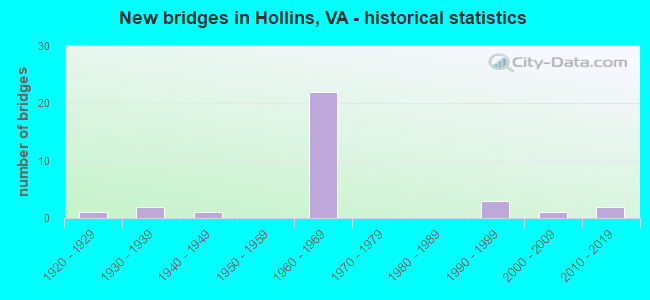
- New bridges - historical statistics
- 11920-1929
- 21930-1939
- 11940-1949
- 221960-1969
- 31990-1999
- 12000-2009
- 22010-2019

- Reconstructed bridges - Historical Statistics
- 41980-1989
- 41990-1999
- 22000-2009


- Bridge Condition - Deck
- 11.1%Very good
- 33.3%Good
- 44.4%Satisfactory
- 11.1%Fair

- Bridge Condition - Superstructure
- 5.6%Very good
- 44.4%Good
- 44.4%Satisfactory
- 5.6%Fair

- Bridge Condition - Substructure
- 5.6%Very good
- 38.9%Good
- 38.9%Satisfactory
- 16.7%Fair

- Bridge Condition - Channel
- 28.6%Very good
- 28.6%Good
- 42.9%Satisfactory

- Bridge Condition - Culverts
- 40.0%Good
- 60.0%Satisfactory
Find on map >> Show street view
Structure Number: 3224, Location: 0.28 ROA CO; 2.79 RT 220 (Lat: 37.364303, Lng: -79.940119), Route carried "on" structure: Interstate 81, Year Built: 1963, Year Reconstructed: 1992, Status: Open, Structure Length: 3.23m (10.60ft), Average Daily Traffic: 23,925 (year 2020), Truck Traffic: 20%, Average Future Daily Traffic: 33,495 (year 2040), Design Load: HS 20+Mod, Features Intersected: RTE 648
Minimum Vertical Clearance: 30+ m (98+ ft), Kilometerpoint: 237.698, Lanes on structure: 2, Lanes under structure: 2, Base Highway Network: Yes, Owner: State Highway Agency, Approaching Roadway Width: 11.0m (36.1ft), Material/Design: Concrete, Design/Construction: Tee Beam, Number Of Spans In Main Unit: 3, Length of Maximum Span: 11.3m (37.1ft), Curb-To-Curb Width: 12.8m (42.0ft), Out-to-Out Width: 13.4m (44.0ft)
Condition: Deck: Satisfactory, Superstructure: Satisfactory, Substructure: Good, Operating Rating: 53.5 metric tons, Method Used To Determine Operating Rating: Load and Resistance Factor (LRFR), Inventory Rating: 41.7 metric tons, Method Used To Determine Inventory Rating: Load and Resistance Factor (LRFR), Structural Evaluation: Equal to present minimum criteria, Deck Geometry: Equal to present desirable criteria, Underclear: Meets minimum limits, Approach Roadway Alignment: Equal to present desirable criteria, Length Of Structure Improvement: 3.23m (10.60ft), Designated Inspection Frequency: Every 24 months, Inspection Date: May 2020, Bridge Improvement Cost: $1,733,000, Roadway Improvement Cost: $520,000, Total Project Cost: $4,715,000 ( Estimate for 2014), Deck Structure Type: Concrete Cast-file-Place, Wearing Surface/Protective System: Wearing Surface: Latex Concrete
Find on map >> Show street view
Structure Number: 3226, Location: 0028ROANOK CO0279220 (Lat: 37.364617, Lng: -79.940197), Route carried "on" structure: Interstate 81, Year Built: 1963, Year Reconstructed: 1992, Status: Open, Structure Length: 3.23m (10.60ft), Average Daily Traffic: 29,067 (year 2020), Truck Traffic: 20%, Average Future Daily Traffic: 40,694 (year 2040), Design Load: HS 20+Mod, Features Intersected: RTE 648
Minimum Vertical Clearance: 30+ m (98+ ft), Kilometerpoint: 238.357, Lanes on structure: 2, Lanes under structure: 2, Base Highway Network: Yes, Owner: State Highway Agency, Approaching Roadway Width: 11.0m (36.1ft), Material/Design: Concrete, Design/Construction: Tee Beam, Number Of Spans In Main Unit: 3, Length of Maximum Span: 11.3m (37.1ft), Curb-To-Curb Width: 12.8m (42.0ft), Out-to-Out Width: 13.4m (44.0ft)
Condition: Deck: Satisfactory, Superstructure: Satisfactory, Substructure: Good, Operating Rating: 54.4 metric tons, Method Used To Determine Operating Rating: Load and Resistance Factor (LRFR), Inventory Rating: 41.7 metric tons, Method Used To Determine Inventory Rating: Load and Resistance Factor (LRFR), Structural Evaluation: Equal to present minimum criteria, Deck Geometry: Equal to present desirable criteria, Underclear: Meets minimum limits, Approach Roadway Alignment: Equal to present desirable criteria, Designated Inspection Frequency: Every 24 months, Inspection Date: May 2020, Deck Structure Type: Concrete Cast-file-Place, Wearing Surface/Protective System: Wearing Surface: Latex Concrete
Find on map >> Show street view
Structure Number: 14844, Location: 0.01-BOTE CO; 1.52-RT 117 (Lat: 37.356003, Lng: -79.929433), Route carried "on" structure: US 11, Year Built: 1947, Year Reconstructed: 2000, Status: Open, Structure Length: 2.71m (8.89ft), Average Daily Traffic: 9,403 (year 2020), Truck Traffic: 1%, Average Future Daily Traffic: 10,343 (year 2040), Design Load: HS 20+Mod, Features Intersected: TINKER CREEK
Minimum Vertical Clearance: 30+ m (98+ ft), Kilometerpoint: 255.773, Lanes on structure: 4, Base Highway Network: Yes, Owner: State Highway Agency, Approaching Roadway Width: 15.8m (51.8ft), Skew: 24 degrees, Material/Design: Steel continuous, Design/Construction: Stringer/Multi-beam, Number Of Spans In Main Unit: 2, Length of Maximum Span: 13.2m (43.3ft), Curb or Sidewalk Widths: Left: 1.2m (3.9ft), Right: 1.2m (3.9ft), Curb-To-Curb Width: 23.0m (75.5ft), Out-to-Out Width: 26.2m (86.0ft)
Condition: Deck: Good, Superstructure: Good, Substructure: Satisfactory, Channel: Satisfactory, Operating Rating: 89.8 metric tons, Method Used To Determine Operating Rating: Load and Resistance Factor (LRFR), Inventory Rating: 69.9 metric tons, Method Used To Determine Inventory Rating: Load and Resistance Factor (LRFR), Structural Evaluation: Equal to present minimum criteria, Deck Geometry: Superior to present desirable criteria, Waterway Adequacy: Equal to present minimum criteria, Approach Roadway Alignment: Equal to present desirable criteria, Designated Inspection Frequency: Every 24 months, Inspection Date: October 2020, Deck Structure Type: Concrete Cast-file-Place, Wearing Surface/Protective System: Deck Protection: Epoxy Coated Reinforcing
Find on map >> Show street view
Structure Number: 14846, Location: 0.92-Rte117; 1.25-Rte118 (Lat: 37.333842, Lng: -79.954714), Route carried "on" structure: US 11, Year Built: 1929, Year Reconstructed: 1995, Status: Open, Structure Length: 1.16m (3.81ft), Average Daily Traffic: 9,403 (year 2020), Truck Traffic: 1%, Average Future Daily Traffic: 10,343 (year 2040), Features Intersected: Boxley Creek
Minimum Vertical Clearance: 30+ m (98+ ft), Kilometerpoint: 251.846, Lanes on structure: 3, Base Highway Network: Yes, Owner: State Highway Agency, Approaching Roadway Width: 9.4m (30.8ft), Skew: 3 degrees, Material/Design: Steel, Design/Construction: Stringer/Multi-beam, Number Of Spans In Main Unit: 1, Length of Maximum Span: 11.6m (38.1ft), Curb-To-Curb Width: 11.9m (39.0ft), Out-to-Out Width: 12.5m (41.0ft)
Condition: Deck: Good, Superstructure: Satisfactory, Substructure: Satisfactory, Channel: Satisfactory, Operating Rating: 48.1 metric tons, Method Used To Determine Operating Rating: Load and Resistance Factor (LRFR), Inventory Rating: 37.2 metric tons, Method Used To Determine Inventory Rating: Load and Resistance Factor (LRFR), Structural Evaluation: Equal to present minimum criteria, Deck Geometry: High priority of corrective action, Waterway Adequacy: Meets minimum limits, Approach Roadway Alignment: Equal to present desirable criteria, Length Of Structure Improvement: 1.68m (5.51ft), Designated Inspection Frequency: Every 24 months, Inspection Date: December 2021, Bridge Improvement Cost: $198,000, Roadway Improvement Cost: $20,000, Total Project Cost: $297,000 ( Estimate for 2021), Deck Structure Type: Wood or Timber, Wearing Surface/Protective System: Wearing Surface: Bituminous, Membrane: Other
Find on map >> Show street view
Structure Number: 14879, Location: 3.59-RT419; 1.40-RT115 (Lat: 37.353169, Lng: -79.981164), Route carried "on" structure: Interstate 81, Year Built: 1963, Year Reconstructed: 1988, Status: Open, Structure Length: 3.35m (10.99ft), Average Daily Traffic: 26,068 (year 2020), Truck Traffic: 21%, Average Future Daily Traffic: 36,495 (year 2040), Design Load: HS 20+Mod, Features Intersected: RTE 1836_BELLE HAVEN RD.
Minimum Vertical Clearance: 30+ m (98+ ft), Kilometerpoint: 234.319, Lanes on structure: 2, Lanes under structure: 2, Base Highway Network: Yes, Owner: State Highway Agency, Approaching Roadway Width: 11.9m (39.0ft), Material/Design: Concrete, Design/Construction: Tee Beam, Number Of Spans In Main Unit: 3, Length of Maximum Span: 11.3m (37.1ft), Curb-To-Curb Width: 12.8m (42.0ft), Out-to-Out Width: 13.4m (44.0ft)
Condition: Deck: Satisfactory, Superstructure: Good, Substructure: Satisfactory, Operating Rating: 51.7 metric tons, Method Used To Determine Operating Rating: Load and Resistance Factor (LRFR), Inventory Rating: 39.9 metric tons, Method Used To Determine Inventory Rating: Load and Resistance Factor (LRFR), Structural Evaluation: Equal to present minimum criteria, Deck Geometry: Equal to present desirable criteria, Underclear: Meets minimum limits, Approach Roadway Alignment: Equal to present desirable criteria, Designated Inspection Frequency: Every 24 months, Inspection Date: June 2021, Deck Structure Type: Concrete Cast-file-Place, Wearing Surface/Protective System: Wearing Surface: Latex Concrete
Find on map >> Show street view
Structure Number: 14881, Location: 3.58-RT419; 1.40-RTE 115 (Lat: 37.353033, Lng: -79.980953), Route carried "on" structure: Interstate 81, Year Built: 1963, Status: Open, Structure Length: 3.35m (10.99ft), Average Daily Traffic: 26,561 (year 2020), Truck Traffic: 21%, Average Future Daily Traffic: 37,185 (year 2040), Design Load: HS 20+Mod, Features Intersected: RTE 1836_BELLE HAVEN RD.
Minimum Vertical Clearance: 30+ m (98+ ft), Kilometerpoint: 233.772, Lanes on structure: 2, Lanes under structure: 2, Base Highway Network: Yes, Owner: State Highway Agency, Approaching Roadway Width: 11.9m (39.0ft), Material/Design: Concrete, Design/Construction: Tee Beam, Number Of Spans In Main Unit: 3, Length of Maximum Span: 11.3m (37.1ft), Curb-To-Curb Width: 12.8m (42.0ft), Out-to-Out Width: 13.4m (44.0ft)
Condition: Deck: Satisfactory, Superstructure: Good, Substructure: Satisfactory, Operating Rating: 51.7 metric tons, Method Used To Determine Operating Rating: Load and Resistance Factor (LRFR), Inventory Rating: 39.9 metric tons, Method Used To Determine Inventory Rating: Load and Resistance Factor (LRFR), Structural Evaluation: Equal to present minimum criteria, Deck Geometry: Equal to present desirable criteria, Underclear: Meets minimum limits, Approach Roadway Alignment: Equal to present desirable criteria, Designated Inspection Frequency: Every 24 months, Inspection Date: June 2021, Deck Structure Type: Concrete Cast-file-Place, Wearing Surface/Protective System: Wearing Surface: Latex Concrete
Find on map >> Show street view
Structure Number: 14891, Location: 2.31-RT419; 3.43-BOTET CO (Lat: 37.340369, Lng: -79.998414), Route carried "on" structure: Interstate 81, Year Built: 1963, Year Reconstructed: 1987, Status: Open, Structure Length: 10.85m (35.60ft), Average Daily Traffic: 31,668 (year 2020), Truck Traffic: 22%, Average Future Daily Traffic: 44,335 (year 2040), Design Load: HS 20+Mod, Features Intersected: 81SB Ramp to 581SBL
Minimum Vertical Clearance: 30+ m (98+ ft), Kilometerpoint: 231.439, Lanes on structure: 2, Lanes under structure: 2, Base Highway Network: Yes, Owner: State Highway Agency, Approaching Roadway Width: 11.9m (39.0ft), Skew: 9 degrees, Material/Design: Steel, Design/Construction: Stringer/Multi-beam, Number Of Spans In Main Unit: 5, Length of Maximum Span: 27.5m (90.2ft), Curb or Sidewalk Widths: Left: 0.8m (2.6ft), Right: 0.8m (2.6ft), Curb-To-Curb Width: 9.1m (29.9ft), Out-to-Out Width: 11.3m (37.1ft)
Condition: Deck: Fair, Superstructure: Fair, Substructure: Fair, Operating Rating: 55.3 metric tons, Method Used To Determine Operating Rating: Load and Resistance Factor (LRFR), Inventory Rating: 42.6 metric tons, Method Used To Determine Inventory Rating: Load and Resistance Factor (LRFR), Structural Evaluation: Somewhat better than minimum adequacy, Deck Geometry: Meets minimum limits, Underclear: High priority of replacement, Approach Roadway Alignment: Equal to present desirable criteria, Length Of Structure Improvement: 10.85m (35.60ft), Designated Inspection Frequency: Every 24 months, Inspection Date: May 2021, Bridge Improvement Cost: $7,745,000, Roadway Improvement Cost: $3,485,000, Total Project Cost: $27,496,000 ( Estimate for 2019), Deck Structure Type: Concrete Cast-file-Place, Wearing Surface/Protective System: Wearing Surface: Latex Concrete
Find on map >> Show street view
Structure Number: 14893, Location: 0.18-SBL 81; 1.07-RT117 (Lat: 37.340875, Lng: -79.997686), Route carried "on" structure: Ramp Interstate 81, Year Built: 1963, Year Reconstructed: 1990, Status: Open, Structure Length: 4.88m (16.01ft), Average Daily Traffic: 10,027 (year 2020), Truck Traffic: 7%, Average Future Daily Traffic: 11,030 (year 2040), Design Load: HS 20+Mod, Features Intersected: UNDR 81NB & ovr 581SB Rp
Minimum Vertical Clearance: 5.23m (17.16ft), Kilometerpoint: 232.613, Lanes on structure: 2, Lanes under structure: 2, Base Highway Network: Yes, Owner: State Highway Agency, Approaching Roadway Width: 12.8m (42.0ft), Skew: 1 degrees, Material/Design: Steel, Design/Construction: Stringer/Multi-beam, Number Of Spans In Main Unit: 3, Length of Maximum Span: 17.1m (56.1ft), Curb-To-Curb Width: 12.8m (42.0ft), Out-to-Out Width: 13.4m (44.0ft)
Condition: Deck: Fair, Superstructure: Satisfactory, Substructure: Fair, Operating Rating: 54.4 metric tons, Method Used To Determine Operating Rating: Load and Resistance Factor (LRFR), Inventory Rating: 42.6 metric tons, Method Used To Determine Inventory Rating: Load and Resistance Factor (LRFR), Structural Evaluation: Somewhat better than minimum adequacy, Deck Geometry: High priority of replacement, Underclear: Meets minimum limits, Approach Roadway Alignment: Equal to present desirable criteria, Length Of Structure Improvement: 6.10m (20.01ft), Designated Inspection Frequency: Every 24 months, Inspection Date: May 2021, Bridge Improvement Cost: $3,484,000, Roadway Improvement Cost: $1,568,000, Total Project Cost: $12,367,000 ( Estimate for 2019), Deck Structure Type: Concrete Cast-file-Place, Wearing Surface/Protective System: Wearing Surface: Latex Concrete
Find on map >> Show street view
Structure Number: 14917, Location: 5.35-Rt419; 0.39-Bot. Co. (Lat: 37.361769, Lng: -79.951064), Route carried "on" structure: Interstate 81, Year Built: 1964, Status: Open, Structure Length: 1.16m (3.81ft), Average Daily Traffic: 52,992 (year 2020), Truck Traffic: 19%, Average Future Daily Traffic: 58,438 (year 2040), Design Load: HS 20, Features Intersected: Carvins Creek
Minimum Vertical Clearance: 30+ m (98+ ft), Kilometerpoint: 236.620, Lanes on structure: 6, Base Highway Network: Yes, Owner: State Highway Agency, Approaching Roadway Width: 23.8m (78.1ft), Material/Design: Concrete, Design/Construction: Culvert, Number Of Spans In Main Unit: 3, Length of Maximum Span: 3.0m (9.8ft)
Condition: Channel: Satisfactory, Culverts: Satisfactory, Operating Rating: 54.4 metric tons, Method Used To Determine Operating Rating: Field evaluation and documented engineering judgment, Inventory Rating: 32.7 metric tons, Method Used To Determine Inventory Rating: Field evaluation and documented engineering judgment, Structural Evaluation: Equal to present minimum criteria, Waterway Adequacy: Better than present minimum criteria, Approach Roadway Alignment: Equal to present desirable criteria, Length Of Structure Improvement: 1.16m (3.81ft), Designated Inspection Frequency: Every 24 months, Inspection Date: March 2021, Bridge Improvement Cost: $891,000, Roadway Improvement Cost: $312,000, Total Project Cost: $2,627,000 ( Estimate for 2015)
Find on map >> Show street view
Structure Number: 14926, Location: 4.76-Rte221; 0.29-Rte11 (Lat: 37.344547, Lng: -79.947436), Route carried "on" structure: State highway 115, Year Built: 1967, Status: Open, Structure Length: 1.10m (3.61ft), Average Daily Traffic: 9,236 (year 2020), Truck Traffic: 3%, Average Future Daily Traffic: 12,930 (year 2040), Design Load: HS 20, Features Intersected: Carvins Creek
Minimum Vertical Clearance: 30+ m (98+ ft), Kilometerpoint: 7.659, Lanes on structure: 2, Owner: State Highway Agency, Approaching Roadway Width: 7.3m (24.0ft), Skew: 1 degrees, Material/Design: Concrete, Design/Construction: Culvert, Number Of Spans In Main Unit: 4, Length of Maximum Span: 2.4m (7.9ft)
Condition: Channel: Satisfactory, Culverts: Good, Operating Rating: 54.4 metric tons, Method Used To Determine Operating Rating: Field evaluation and documented engineering judgment, Inventory Rating: 32.7 metric tons, Method Used To Determine Inventory Rating: Field evaluation and documented engineering judgment, Structural Evaluation: Better than present minimum criteria, Waterway Adequacy: Better than present minimum criteria, Approach Roadway Alignment: Equal to present desirable criteria, Designated Inspection Frequency: Every 24 months, Inspection Date: Febuary 2021
Find on map >> Show street view
Structure Number: 14927, Location: 2.88-Rte221; 0.01-Rte 601 (Lat: 37.320736, Lng: -79.933964), Route carried "on" structure: State highway 115, Year Built: 1965, Status: Open, Structure Length: 1.58m (5.18ft), Average Daily Traffic: 13,226 (year 2020), Truck Traffic: 3%, Average Future Daily Traffic: 18,516 (year 2040), Design Load: HS 20, Features Intersected: Carvins Creek
Minimum Vertical Clearance: 30+ m (98+ ft), Kilometerpoint: 4.634, Lanes on structure: 2, Owner: State Highway Agency, Approaching Roadway Width: 21.6m (70.9ft), Skew: 3 degrees, Material/Design: Concrete, Design/Construction: Culvert, Number Of Spans In Main Unit: 4, Length of Maximum Span: 3.0m (9.8ft)
Condition: Channel: Good, Culverts: Satisfactory, Operating Rating: 54.4 metric tons, Method Used To Determine Operating Rating: Field evaluation and documented engineering judgment, Inventory Rating: 32.7 metric tons, Method Used To Determine Inventory Rating: Field evaluation and documented engineering judgment, Structural Evaluation: Equal to present minimum criteria, Waterway Adequacy: Somewhat better than minimum adequacy, Approach Roadway Alignment: Equal to present desirable criteria, Designated Inspection Frequency: Every 24 months, Inspection Date: March 2021
Find on map >> Show street view
Structure Number: 15023, Location: 0.10-Rte743; 0.22-Rte115 (Lat: 37.322797, Lng: -79.940008), Route carried "on" structure: County highway 625, Year Built: 1932, Status: Open, Structure Length: 1.80m (5.91ft), Average Daily Traffic: 8,018 (year 2020), Truck Traffic: 2%, Average Future Daily Traffic: 9,319 (year 2040), Design Load: HS 20, Features Intersected: Carvins Creek
Minimum Vertical Clearance: 30+ m (98+ ft), Kilometerpoint: 0.595, Lanes on structure: 2, Owner: State Highway Agency, Approaching Roadway Width: 6.7m (22.0ft), Skew: 4 degrees, Material/Design: Concrete, Design/Construction: Culvert, Number Of Spans In Main Unit: 4, Length of Maximum Span: 3.0m (9.8ft)
Condition: Channel: Satisfactory, Culverts: Satisfactory, Operating Rating: 54.4 metric tons, Method Used To Determine Operating Rating: Field evaluation and documented engineering judgment, Inventory Rating: 32.7 metric tons, Method Used To Determine Inventory Rating: Field evaluation and documented engineering judgment, Structural Evaluation: Equal to present minimum criteria, Waterway Adequacy: Better than present minimum criteria, Approach Roadway Alignment: Equal to present desirable criteria, Designated Inspection Frequency: Every 24 months, Inspection Date: March 2021
Find on map >> Show street view
Structure Number: 15026, Location: 1.25RT-629; 1.35RT-117 (Lat: 37.336033, Lng: -79.995833), Route carried "on" structure: County highway 628, Year Built: 1963, Year Reconstructed: 1997, Status: Open, Structure Length: 4.98m (16.34ft), Average Daily Traffic: 2,634 (year 2020), Truck Traffic: 2%, Average Future Daily Traffic: 3,688 (year 2040), Design Load: HS 20+Mod, Features Intersected: RTES I 581 & 220 SBL
Minimum Vertical Clearance: 30+ m (98+ ft), Kilometerpoint: 3.216, Lanes on structure: 2, Lanes under structure: 3, Owner: State Highway Agency, Approaching Roadway Width: 7.3m (24.0ft), Material/Design: Prestressed concrete, Design/Construction: Box Beam or Girders - Multiple, Number Of Spans In Main Unit: 1, Number Of Approach Spans: 2, Length of Maximum Span: 19.2m (63.0ft), Curb-To-Curb Width: 7.2m (23.6ft), Out-to-Out Width: 8.2m (26.9ft)
Condition: Deck: Satisfactory, Superstructure: Satisfactory, Substructure: Satisfactory, Operating Rating: 86.2 metric tons, Method Used To Determine Operating Rating: Load and Resistance Factor (LRFR), Inventory Rating: 66.2 metric tons, Method Used To Determine Inventory Rating: Load and Resistance Factor (LRFR), Structural Evaluation: Equal to present minimum criteria, Deck Geometry: High priority of replacement, Underclear: Somewhat better than minimum adequacy, Approach Roadway Alignment: Equal to present desirable criteria, Length Of Structure Improvement: 5.00m (16.40ft), Designated Inspection Frequency: Every 24 months, Inspection Date: September 2020, Bridge Improvement Cost: $3,412,000, Roadway Improvement Cost: $853,000, Total Project Cost: $10,918,000 ( Estimate for 2019), Deck Structure Type: Concrete Cast-file-Place, Wearing Surface/Protective System: Wearing Surface: Bituminous
Find on map >> Show street view
Structure Number: 15028, Location: 1.30-RT629; 1.30-RT117 (Lat: 37.336322, Lng: -79.994892), Route carried "on" structure: County highway 628, Year Built: 1963, Year Reconstructed: 1997, Status: Open, Structure Length: 5.30m (17.39ft), Average Daily Traffic: 2,634 (year 2020), Truck Traffic: 2%, Average Future Daily Traffic: 3,688 (year 2040), Design Load: HL 93, Features Intersected: RTES I 581 & 220 NBL
Minimum Vertical Clearance: 5.00m (16.40ft), Kilometerpoint: 3.295, Lanes on structure: 2, Lanes under structure: 3, Owner: State Highway Agency, Approaching Roadway Width: 7.0m (23.0ft), Skew: 1 degrees, Material/Design: Prestressed concrete, Design/Construction: Box Beam or Girders - Multiple, Number Of Spans In Main Unit: 1, Number Of Approach Spans: 2, Length of Maximum Span: 20.4m (66.9ft), Curb-To-Curb Width: 7.2m (23.6ft), Out-to-Out Width: 8.2m (26.9ft)
Condition: Deck: Satisfactory, Superstructure: Satisfactory, Substructure: Satisfactory, Operating Rating: 89.8 metric tons, Method Used To Determine Operating Rating: Load and Resistance Factor (LRFR), Inventory Rating: 66.2 metric tons, Method Used To Determine Inventory Rating: Load and Resistance Factor (LRFR), Structural Evaluation: Equal to present minimum criteria, Deck Geometry: High priority of replacement, Underclear: High priority of corrective action, Approach Roadway Alignment: Equal to present desirable criteria, Length Of Structure Improvement: 0.03m (0.10ft), Designated Inspection Frequency: Every 24 months, Inspection Date: September 2020, Bridge Improvement Cost: $3,617,000, Roadway Improvement Cost: $904,000, Total Project Cost: $11,573,000 ( Estimate for 2019), Deck Structure Type: Concrete Cast-file-Place, Wearing Surface/Protective System: Wearing Surface: Bituminous
Find on map >> Show street view
Structure Number: 15124, Location: 0.02-Rte11; 0.23-Rte601 (Lat: 37.355511, Lng: -79.929461), Route carried "on" structure: County highway 856, Year Built: 1931, Status: Posted for load, Structure Length: 1.80m (5.91ft), Average Daily Traffic: 386 (year 2019), Average Future Daily Traffic: 548 (year 2040), Features Intersected: Tinker Creek
Minimum Vertical Clearance: 30+ m (98+ ft), Kilometerpoint: 0.370, Lanes on structure: 2, Owner: State Highway Agency, Approaching Roadway Width: 7.3m (24.0ft), Material/Design: Steel, Design/Construction: Stringer/Multi-beam, Number Of Spans In Main Unit: 1, Length of Maximum Span: 18.0m (59.1ft), Curb or Sidewalk Widths: Left: 0.1m (0.3ft), Right: 0.1m (0.3ft), Curb-To-Curb Width: 12.0m (39.4ft), Out-to-Out Width: 12.9m (42.3ft)
Condition: Deck: Satisfactory, Superstructure: Good, Substructure: Fair, Channel: Very good, Operating Rating: 29.0 metric tons, Method Used To Determine Operating Rating: Load and Resistance Factor (LRFR), Inventory Rating: 21.8 metric tons, Method Used To Determine Inventory Rating: Load and Resistance Factor (LRFR), Structural Evaluation: Somewhat better than minimum adequacy, Deck Geometry: Superior to present desirable criteria, Waterway Adequacy: Somewhat better than minimum adequacy, Approach Roadway Alignment: Equal to present desirable criteria, Length Of Structure Improvement: 2.44m (8.01ft), Designated Inspection Frequency: Every 24 months, Inspection Date: October 2021, Bridge Improvement Cost: $888,000, Roadway Improvement Cost: $222,000, Total Project Cost: $2,842,000 ( Estimate for 2019), Deck Structure Type: Concrete Cast-file-Place, Wearing Surface/Protective System: Wearing Surface: Epoxy Overlay
Find on map >> Show street view
Structure Number: 15145, Location: 0.01 Rt-1815;0.11 Rt-1813 (Lat: 37.346514, Lng: -79.940097), Route carried "on" structure: County highway 1814, Year Built: 1965, Status: Open, Structure Length: 0.76m (2.49ft), Average Daily Traffic: 374 (year 2015), Average Future Daily Traffic: 421 (year 2040), Features Intersected: Carvin Creek
Minimum Vertical Clearance: 30+ m (98+ ft), Kilometerpoint: 0.557, Lanes on structure: 2, Owner: State Highway Agency, Approaching Roadway Width: 5.5m (18.0ft), Material/Design: Steel, Design/Construction: Stringer/Multi-beam, Number Of Spans In Main Unit: 1, Length of Maximum Span: 7.3m (24.0ft), Curb or Sidewalk Widths: Left: 0.2m (0.7ft), Right: 0.2m (0.7ft), Curb-To-Curb Width: 7.0m (23.0ft), Out-to-Out Width: 7.6m (24.9ft)
Condition: Deck: Very good, Superstructure: Good, Substructure: Good, Channel: Satisfactory, Operating Rating: 78.9 metric tons, Method Used To Determine Operating Rating: Load and Resistance Factor (LRFR), Inventory Rating: 60.8 metric tons, Method Used To Determine Inventory Rating: Load and Resistance Factor (LRFR), Structural Evaluation: Better than present minimum criteria, Deck Geometry: Meets minimum limits, Waterway Adequacy: Somewhat better than minimum adequacy, Approach Roadway Alignment: Equal to present desirable criteria, Designated Inspection Frequency: Every 24 months, Inspection Date: March 2020, Deck Structure Type: Wood or Timber, Wearing Surface/Protective System: Wearing Surface: Bituminous, Membrane: Other
Find on map >> Show street view
Structure Number: 24779, Location: 0.11-Rte1834;0.05-Rte1816 (Lat: 37.347400, Lng: -79.936100), Route carried "on" structure: County highway 1835, Year Built: 1996, Status: Open, Structure Length: 1.43m (4.69ft), Average Daily Traffic: 572 (year 2015), Average Future Daily Traffic: 742 (year 2040), Design Load: HL 93, Features Intersected: Tinker Creek
Minimum Vertical Clearance: 30+ m (98+ ft), Kilometerpoint: 0.080, Lanes on structure: 2, Owner: State Highway Agency, Approaching Roadway Width: 7.3m (24.0ft), Material/Design: Prestressed concrete, Design/Construction: Slab, Number Of Spans In Main Unit: 1, Length of Maximum Span: 14.3m (46.9ft), Curb-To-Curb Width: 8.5m (27.9ft), Out-to-Out Width: 9.1m (29.9ft)
Condition: Deck: Good, Superstructure: Good, Substructure: Good, Channel: Good, Operating Rating: 64.4 metric tons, Method Used To Determine Operating Rating: Load and Resistance Factor (LRFR), Inventory Rating: 49.9 metric tons, Method Used To Determine Inventory Rating: Load and Resistance Factor (LRFR), Structural Evaluation: Better than present minimum criteria, Deck Geometry: Somewhat better than minimum adequacy, Waterway Adequacy: Better than present minimum criteria, Approach Roadway Alignment: Equal to present desirable criteria, Designated Inspection Frequency: Every 24 months, Inspection Date: December 2020, Deck Structure Type: Concrete Precast Panels, Wearing Surface/Protective System: Wearing Surface: Bituminous
Find on map >> Show street view
Structure Number: 2478, Location: 0.05-Rte1862 0.13-Rte1816 (Lat: 37.343978, Lng: -79.934711), Route carried "on" structure: County highway 1861, Year Built: 1996, Status: Open, Structure Length: 1.16m (3.81ft), Average Daily Traffic: 603 (year 2015), Average Future Daily Traffic: 678 (year 2040), Design Load: HL 93, Features Intersected: Tinker Creek
Minimum Vertical Clearance: 30+ m (98+ ft), Kilometerpoint: 0.409, Lanes on structure: 2, Owner: State Highway Agency, Approaching Roadway Width: 5.8m (19.0ft), Material/Design: Prestressed concrete, Design/Construction: Slab, Number Of Spans In Main Unit: 1, Length of Maximum Span: 11.6m (38.1ft), Curb-To-Curb Width: 8.4m (27.6ft), Out-to-Out Width: 9.1m (29.9ft)
Condition: Deck: Good, Superstructure: Good, Substructure: Good, Channel: Very good, Operating Rating: 59.9 metric tons, Method Used To Determine Operating Rating: Load and Resistance Factor (LRFR), Inventory Rating: 46.3 metric tons, Method Used To Determine Inventory Rating: Load and Resistance Factor (LRFR), Structural Evaluation: Better than present minimum criteria, Deck Geometry: Somewhat better than minimum adequacy, Waterway Adequacy: Equal to present minimum criteria, Approach Roadway Alignment: Equal to present desirable criteria, Designated Inspection Frequency: Every 24 months, Inspection Date: December 2020, Deck Structure Type: Concrete Precast Panels, Wearing Surface/Protective System: Wearing Surface: Bituminous, Deck Protection: Epoxy Coated Reinforcing
Find on map >> Show street view
Structure Number: 26085, Location: 0.18-RT115; 0.62-RT616 (Lat: 37.322775, Lng: -79.932064), Route carried "on" structure: County highway 601, Year Built: 2006, Status: Open, Structure Length: 2.87m (9.42ft), Average Daily Traffic: 5,638 (year 2020), Truck Traffic: 4%, Average Future Daily Traffic: 6,202 (year 2040), Design Load: HS 20+Mod, Features Intersected: Tinker Creek
Minimum Vertical Clearance: 30+ m (98+ ft), Kilometerpoint: 0.290, Lanes on structure: 2, Owner: State Highway Agency, Approaching Roadway Width: 19.2m (63.0ft), Material/Design: Concrete, Design/Construction: Slab, Number Of Spans In Main Unit: 3, Length of Maximum Span: 11.0m (36.1ft), Curb or Sidewalk Widths: Left: 1.8m (5.9ft), Right: 1.8m (5.9ft), Curb-To-Curb Width: 19.2m (63.0ft), Out-to-Out Width: 23.6m (77.4ft)
Condition: Deck: Good, Superstructure: Good, Substructure: Good, Channel: Good, Operating Rating: 67.1 metric tons, Method Used To Determine Operating Rating: Load and Resistance Factor (LRFR), Inventory Rating: 51.7 metric tons, Method Used To Determine Inventory Rating: Load and Resistance Factor (LRFR), Structural Evaluation: Better than present minimum criteria, Deck Geometry: Superior to present desirable criteria, Waterway Adequacy: Somewhat better than minimum adequacy, Approach Roadway Alignment: Equal to present desirable criteria, Designated Inspection Frequency: Every 24 months, Inspection Date: August 2020, Deck Structure Type: Concrete Cast-file-Place, Wearing Surface/Protective System: Deck Protection: Epoxy Coated Reinforcing
Find on map >> Show street view
Structure Number: 26184, Location: 0.07-Rte1859; 0.06-Rte623 (Lat: 37.329967, Lng: -79.950914), Route carried "on" structure: County highway 1867, Year Built: 1999, Status: Open, Structure Length: 1.22m (4.00ft), Average Daily Traffic: 3,224 (year 2015), Average Future Daily Traffic: 3,627 (year 2040), Features Intersected: Carvin Creek
Minimum Vertical Clearance: 30+ m (98+ ft), Kilometerpoint: 0.097, Lanes on structure: 2, Owner: State Highway Agency, Approaching Roadway Width: 5.5m (18.0ft), Skew: 1 degrees, Material/Design: Concrete, Design/Construction: Slab, Number Of Spans In Main Unit: 1, Length of Maximum Span: 12.2m (40.0ft), Curb or Sidewalk Widths: Left: 0.4m (1.3ft), Right: 0.4m (1.3ft), Curb-To-Curb Width: 8.5m (27.9ft), Out-to-Out Width: 9.3m (30.5ft)
Condition: Deck: Satisfactory, Superstructure: Satisfactory, Substructure: Good, Channel: Very good, Operating Rating: 92.5 metric tons, Method Used To Determine Operating Rating: Load and Resistance Factor (LRFR), Inventory Rating: 71.7 metric tons, Method Used To Determine Inventory Rating: Load and Resistance Factor (LRFR), Structural Evaluation: Equal to present minimum criteria, Deck Geometry: Meets minimum limits, Waterway Adequacy: Better than present minimum criteria, Approach Roadway Alignment: Equal to present desirable criteria, Designated Inspection Frequency: Every 24 months, Inspection Date: August 2021, Deck Structure Type: Concrete Cast-file-Place, Wearing Surface/Protective System: Deck Protection: Epoxy Coated Reinforcing
Find on map >> Show street view
Structure Number: 27693, Location: 0.02-RT F072; 0.25-RT1865 (Lat: 37.360797, Lng: -79.957747), Route carried "on" structure: State highway 115, Year Built: 1963, Year Reconstructed: 2008, Status: Open, Structure Length: 7.13m (23.39ft), Average Daily Traffic: 10,519 (year 2020), Truck Traffic: 4%, Average Future Daily Traffic: 12,890 (year 2040), Design Load: HS 20, Features Intersected: RTES I81 & 220
Minimum Vertical Clearance: 30+ m (98+ ft), Kilometerpoint: 0.000, Lanes on structure: 2, Lanes under structure: 4, Owner: State Highway Agency, Approaching Roadway Width: 7.9m (25.9ft), Material/Design: Concrete, Design/Construction: Stringer/Multi-beam, Number Of Spans In Main Unit: 4, Length of Maximum Span: 21.3m (69.9ft), Curb-To-Curb Width: 9.1m (29.9ft), Out-to-Out Width: 10.1m (33.1ft)
Condition: Deck: Good, Superstructure: Satisfactory, Substructure: Satisfactory, Operating Rating: 77.1 metric tons, Method Used To Determine Operating Rating: Load and Resistance Factor (LRFR), Inventory Rating: 50.8 metric tons, Method Used To Determine Inventory Rating: Load and Resistance Factor (LRFR), Structural Evaluation: Equal to present minimum criteria, Deck Geometry: Meets minimum limits, Underclear: Somewhat better than minimum adequacy, Approach Roadway Alignment: Equal to present desirable criteria, Designated Inspection Frequency: Every 24 months, Inspection Date: November 2020, Bridge Improvement Cost: $3,321,000, Roadway Improvement Cost: $1,163,000, Total Project Cost: $10,795,000 ( Estimate for 2015), Deck Structure Type: Concrete Cast-file-Place, Wearing Surface/Protective System: Wearing Surface: Monolithic Concrete
Find on map >> Show street view
Structure Number: 29512, Location: 2.31 RCL; .53 Rt 220 (Lat: 37.361389, Lng: -79.923333), Route carried "on" structure: US 11, Year Built: 2018, Status: Open, Structure Length: 2.00m (6.56ft), Average Daily Traffic: 4,685 (year 2020), Average Future Daily Traffic: 5,716 (year 2040), Design Load: HL 93, Features Intersected: Tinker Creek, Facility Carried by Structure: Lee Highway
Minimum Vertical Clearance: 30+ m (98+ ft), Kilometerpoint: 256.636, Lanes on structure: 1, Owner: State Highway Agency, Approaching Roadway Width: 16.8m (55.1ft), Skew: 2 degrees, Material/Design: Concrete, Design/Construction: Tee Beam, Number Of Spans In Main Unit: 1, Length of Maximum Span: 17.4m (57.1ft), Curb or Sidewalk Widths: Left: 0.4m (1.3ft), Right: 0.4m (1.3ft), Curb-To-Curb Width: 16.8m (55.1ft), Out-to-Out Width: 17.6m (57.7ft)
Condition: Deck: Very good, Superstructure: Very good, Substructure: Very good, Channel: Very good, Operating Rating: 74.4 metric tons, Method Used To Determine Operating Rating: Load and Resistance Factor (LRFR), Inventory Rating: 50.8 metric tons, Method Used To Determine Inventory Rating: Load and Resistance Factor (LRFR), Structural Evaluation: Equal to present desirable criteria, Deck Geometry: Superior to present desirable criteria, Waterway Adequacy: Superior to present desirable criteria, Approach Roadway Alignment: Equal to present desirable criteria, Length Of Structure Improvement: 2.00m (6.56ft), Designated Inspection Frequency: Every 24 months, Inspection Date: July 2020, Bridge Improvement Cost: $1,203,000, Roadway Improvement Cost: $230,000, Total Project Cost: $3,259,000 ( Estimate for 2018), Deck Structure Type: Concrete Cast-file-Place, Wearing Surface/Protective System: Deck Protection: Other
Find on map >> Show street view
Structure Number: 29573, Location: 0.70-Rke. CL; 0.15-End Ma (Lat: 37.393056, Lng: -79.997111), Route carried "on" structure: County highway 740, Year Built: 2011, Status: Open, Structure Length: 0.63m (2.07ft), Average Daily Traffic: 179 (year 2016), Average Future Daily Traffic: 265 (year 2040), Design Load: HL 93, Features Intersected: Carvin Creek, Facility Carried by Structure: Carvins Cove Rd.
Minimum Vertical Clearance: 30.45m (99.90ft), Kilometerpoint: 0.000, Lanes on structure: 2, Owner: State Highway Agency, Approaching Roadway Width: 4.3m (14.1ft), Material/Design: Concrete, Design/Construction: Culvert, Number Of Spans In Main Unit: 2, Length of Maximum Span: 3.0m (9.8ft)
Condition: Channel: Good, Culverts: Good, Operating Rating: 71.7 metric tons, Method Used To Determine Operating Rating: Load Factor (LF), Inventory Rating: 42.6 metric tons, Method Used To Determine Inventory Rating: Load Factor (LF), Structural Evaluation: Better than present minimum criteria, Waterway Adequacy: Equal to present desirable criteria, Approach Roadway Alignment: Equal to present desirable criteria, Length Of Structure Improvement: 0.64m (2.10ft), Designated Inspection Frequency: Every 24 months, Inspection Date: Febuary 2020, Bridge Improvement Cost: $297,000, Roadway Improvement Cost: $74,000, Total Project Cost: $949,000 ( Estimate for 2020)
Find on map >> Show street view
Structure Number: 3224, Location: 0.28 ROA CO; 2.79 RT 220 (Lat: 37.364303, Lng: -79.940119), Route carried "under" structure: County highway 648, Year Built: 1963, Structure Length: 0. m, Average Daily Traffic: 508 (year 1994), Features Intersected: RTE 648, Facility Carried by Structure: NBL ROUTE 0081
Minimum Vertical Clearance: 4.70m (15.42ft), Kilometerpoint: 56.154, Lanes on structure: 2, Lanes under structure: 2, Material/Design: Concrete, Design/Construction: Tee Beam, Length of Maximum Span: 11.3m (37.1ft)
Find on map >> Show street view
Structure Number: 3226, Location: 0028ROANOK CO0279220 (Lat: 37.364617, Lng: -79.940197), Route carried "under" structure: County highway 648, Year Built: 1963, Structure Length: 0. m, Average Daily Traffic: 508 (year 1994), Features Intersected: RTE 648, Facility Carried by Structure: SBL ROUTE 0081
Minimum Vertical Clearance: 4.57m (14.99ft), Kilometerpoint: 0.000, Lanes on structure: 2, Lanes under structure: 2, Material/Design: Concrete, Design/Construction: Tee Beam, Length of Maximum Span: 11.3m (37.1ft)
Find on map >> Show street view
Structure Number: 14879, Location: 3.59-RT419; 1.40-RT115 (Lat: 37.353169, Lng: -79.981164), Route carried "under" structure: County highway 1836, Year Built: 1963, Structure Length: 0. m, Average Daily Traffic: 1,600 (year 2015), Features Intersected: RTE 1836_BELLE HAVEN RD., Facility Carried by Structure: SBL ROUTE 0081
Minimum Vertical Clearance: 4.34m (14.24ft), Kilometerpoint: 0.563, Lanes on structure: 2, Lanes under structure: 2, Material/Design: Concrete, Design/Construction: Tee Beam, Length of Maximum Span: 11.3m (37.1ft)
Find on map >> Show street view
Structure Number: 14881, Location: 3.58-RT419; 1.40-RTE 115 (Lat: 37.353033, Lng: -79.980953), Route carried "under" structure: County highway 1836, Year Built: 1963, Structure Length: 0. m, Average Daily Traffic: 1,600 (year 2015), Features Intersected: RTE 1836_BELLE HAVEN RD., Facility Carried by Structure: NBL ROUTE 0081
Minimum Vertical Clearance: 4.47m (14.67ft), Kilometerpoint: 0.000, Lanes on structure: 2, Lanes under structure: 2, Material/Design: Concrete, Design/Construction: Tee Beam, Length of Maximum Span: 11.3m (37.1ft)
Find on map >> Show street view
Structure Number: 14891, Location: 2.31-RT419; 3.43-BOTET CO (Lat: 37.340369, Lng: -79.998414), Route carried "under" structure: Ramp Interstate 81, Year Built: 1963, Structure Length: 0. m, Average Daily Traffic: 9,300 (year 2017), Truck Traffic: 7%, Features Intersected: 81SB Ramp to 581SBL
Minimum Vertical Clearance: 5.23m (17.16ft), Kilometerpoint: 0.000, Lanes on structure: 2, Lanes under structure: 2, Material/Design: Steel, Design/Construction: Stringer/Multi-beam, Length of Maximum Span: 27.5m (90.2ft)
Find on map >> Show street view
Structure Number: 14893, Location: 0.18-SBL 81; 1.07-RT117 (Lat: 37.340875, Lng: -79.997686), Route carried "under" structure: Interstate 581, Year Built: 1963, Structure Length: 0. m, Average Daily Traffic: 25,772 (year 2008), Truck Traffic: 3%, Features Intersected: UNDR 81NB & ovr 581SB Rp
Minimum Vertical Clearance: 5.35m (17.55ft), Kilometerpoint: 10.394, Lanes on structure: 2, Lanes under structure: 2, Material/Design: Steel, Design/Construction: Stringer/Multi-beam, Length of Maximum Span: 17.1m (56.1ft)
Find on map >> Show street view
Structure Number: 15026, Location: 1.25RT-629; 1.35RT-117 (Lat: 37.336033, Lng: -79.995833), Route carried "under" structure: Interstate 581, Year Built: 1963, Structure Length: 0. m, Average Daily Traffic: 23,000 (year 2018), Truck Traffic: 7%, Features Intersected: RTES I 581 & 220 SBL, Facility Carried by Structure: WOODHAVEN RD/628
Minimum Vertical Clearance: 5.12m (16.80ft), Kilometerpoint: 9.702, Lanes on structure: 2, Lanes under structure: 3, Material/Design: Prestressed concrete, Design/Construction: Box Beam or Girders - Multiple, Length of Maximum Span: 19.2m (63.0ft)
Find on map >> Show street view
Structure Number: 15028, Location: 1.30-RT629; 1.30-RT117 (Lat: 37.336322, Lng: -79.994892), Route carried "under" structure: Interstate 581, Year Built: 1963, Structure Length: 0. m, Average Daily Traffic: 23,000 (year 2018), Truck Traffic: 7%, Features Intersected: RTES I 581 & 220 NBL, Facility Carried by Structure: WOODHAVEN RD/628
Minimum Vertical Clearance: 5.13m (16.83ft), Kilometerpoint: 9.702, Lanes on structure: 2, Lanes under structure: 3, Material/Design: Prestressed concrete, Design/Construction: Box Beam or Girders - Multiple, Length of Maximum Span: 20.4m (66.9ft)
Find on map >> Show street view
Structure Number: 27693, Location: 0.02-RT F072; 0.25-RT1865 (Lat: 37.360797, Lng: -79.957747), Route carried "under" structure: Interstate 81, Year Built: 1963, Structure Length: 0. m, Average Daily Traffic: 64,000 (year 2019), Truck Traffic: 22%, Features Intersected: RTES I81 & 220, Facility Carried by Structure: Plantation Rd/115
Minimum Vertical Clearance: 5.18m (16.99ft), Kilometerpoint: 235.769, Lanes on structure: 2, Lanes under structure: 4, Material/Design: Concrete, Design/Construction: Stringer/Multi-beam, Length of Maximum Span: 21.3m (69.9ft)