Bridge Statistics for Honolulu, Hawaii (HI)
Condition, Traffic, Stress, Structural Evaluation, Project Costs
- National Bridge Inventory (NBI) Statistics
- 272Number of bridges
- 10,568ft / 3,221mTotal length
- $321,621,000Total costs
- 10,823,407Total average daily traffic
- 246,945Total average daily truck traffic
- 15,040,192Total future (year 2023) average daily traffic
- National Bridge Inventory (NBI) Registered Bridges for Honolulu
- No street view available for this location
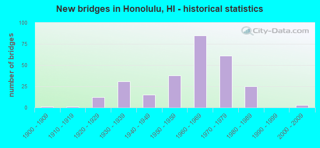
- New bridges - historical statistics
- 11900-1909
- 11910-1919
- 121920-1929
- 311930-1939
- 151940-1949
- 381950-1959
- 851960-1969
- 611970-1979
- 251980-1989
- 32000-2009
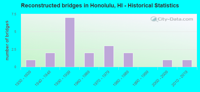
- Reconstructed bridges - Historical Statistics
- 11930-1939
- 21940-1949
- 71950-1959
- 21960-1969
- 31970-1979
- 21980-1989
- 01990-1999
- 12000-2009
- 12010-2019
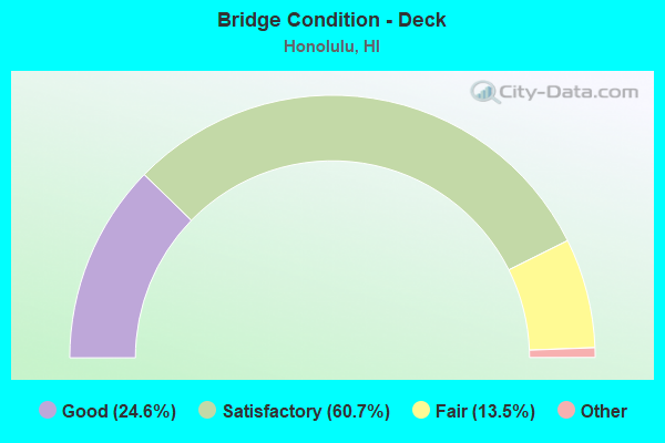
- Bridge Condition - Deck
- 24.6%Very good
- 60.7%Good
- 13.5%Satisfactory
- 1.2%Fair
- 0.8%Poor
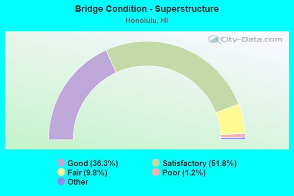
- Bridge Condition - Superstructure
- 36.3%Very good
- 51.8%Good
- 9.8%Satisfactory
- 1.2%Fair
- 0.8%Poor
- 0.4%Serious
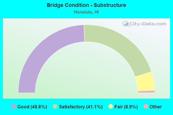
- Bridge Condition - Substructure
- 48.8%Very good
- 41.1%Good
- 8.9%Satisfactory
- 1.2%Fair
- 0.8%Poor
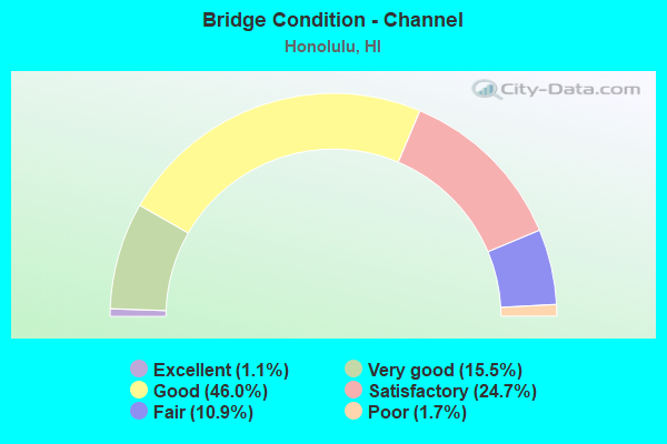
- Bridge Condition - Channel
- 1.1%Excellent
- 15.5%Very good
- 46.0%Good
- 24.7%Satisfactory
- 10.9%Fair
- 1.7%Poor
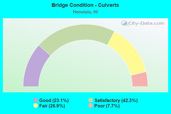
- Bridge Condition - Culverts
- 23.1%Good
- 42.3%Satisfactory
- 26.9%Fair
- 7.7%Poor
Find on map >> Show street view
Structure Number: 1HI851, Location: 0.9 KM E OF SEAMAN AVE (Lat: 21.319686, Lng: -157.949708), Route carried "on" structure: Other road , Year Built: 1943, Status: Open, Structure Length: 1.79m (5.87ft), Average Daily Traffic: 500 (year 2017), Truck Traffic: 10%, Average Future Daily Traffic: 750 (year 2039), Features Intersected: KUMUMAUU CANAL, Facility Carried by Structure: MAMALA BAY DRIVE
Minimum Vertical Clearance: 30+ m (98+ ft), Kilometerpoint: 0.000, Lanes on structure: 2, Owner: Navy/Marines, Approaching Roadway Width: 8.1m (26.6ft), Material/Design: Concrete, Design/Construction: Culvert, Number Of Spans In Main Unit: 9, Length of Maximum Span: 1.7m (5.6ft), Curb-To-Curb Width: 10.0m (32.8ft), Out-to-Out Width: 10.8m (35.4ft)
Condition: Channel: Fair, Culverts: Satisfactory, Operating Rating: 28.2 metric tons, Method Used To Determine Operating Rating: Load and Resistance Factor Rating (LRFR) rating reported by rating factor(RF) method using HL-93 loadings, Inventory Rating: 21.7 metric tons, Method Used To Determine Inventory Rating: Load and Resistance Factor Rating (LRFR) rating reported by rating factor(RF) method using HL-93 loadings, Structural Evaluation: Equal to present minimum criteria, Deck Geometry: Equal to present minimum criteria, Waterway Adequacy: Equal to present desirable criteria, Approach Roadway Alignment: Equal to present minimum criteria, Length Of Structure Improvement: 1.79m (5.87ft), Designated Inspection Frequency: Every 24 months, Inspection Date: May 2021, Bridge Improvement Cost: $14,000, Roadway Improvement Cost: $63,000, Total Project Cost: $77,000 ( Estimate for 2021)
Find on map >> Show street view
Structure Number: 1HI8511, Location: 0.1 KM NE OF KUNTZ AVE (Lat: 21.335603, Lng: -157.935044), Route carried "on" structure: Other road , Year Built: 1944, Year Reconstructed: 1956, Status: Open, Structure Length: 1.46m (4.79ft), Average Daily Traffic: 750 (year 2017), Truck Traffic: 10%, Average Future Daily Traffic: 1,000 (year 2039), Features Intersected: MANUWAI CANAL, Facility Carried by Structure: HALEHAKA STREET
Minimum Vertical Clearance: 30+ m (98+ ft), Kilometerpoint: 0.000, Lanes on structure: 2, Owner: Navy/Marines, Approaching Roadway Width: 10.3m (33.8ft), Material/Design: Concrete, Design/Construction: Slab, Number Of Spans In Main Unit: 2, Length of Maximum Span: 6.9m (22.6ft), Curb-To-Curb Width: 9.8m (32.2ft), Out-to-Out Width: 10.7m (35.1ft)
Condition: Deck: Satisfactory, Superstructure: Satisfactory, Substructure: Fair, Channel: Satisfactory, Operating Rating: 24.0 metric tons, Method Used To Determine Operating Rating: Load and Resistance Factor Rating (LRFR) rating reported by rating factor(RF) method using HL-93 loadings, Inventory Rating: 18.5 metric tons, Method Used To Determine Inventory Rating: Load and Resistance Factor Rating (LRFR) rating reported by rating factor(RF) method using HL-93 loadings, Structural Evaluation: Somewhat better than minimum adequacy, Deck Geometry: Equal to present minimum criteria, Waterway Adequacy: Equal to present desirable criteria, Approach Roadway Alignment: Equal to present desirable criteria, Length Of Structure Improvement: 1.46m (4.79ft), Designated Inspection Frequency: Every 24 months, Inspection Date: May 2021, Bridge Improvement Cost: $29,000, Roadway Improvement Cost: $65,000, Total Project Cost: $94,000 ( Estimate for 2021), Deck Structure Type: Concrete Cast-file-Place, Wearing Surface/Protective System: Wearing Surface: Monolithic Concrete
Find on map >> Show street view
Structure Number: 1HI85112, Location: 143 M SE OF HICKAM GATE (Lat: 21.340053, Lng: -157.945064), Route carried "on" structure: Other road , Year Built: 1976, Status: Open, Structure Length: 4.63m (15.19ft), Average Daily Traffic: 1,500 (year 2017), Truck Traffic: 10%, Average Future Daily Traffic: 2,000 (year 2039), Features Intersected: O'MALLEY BLVD, Facility Carried by Structure: VANDENBURG BLVD
Minimum Vertical Clearance: 30+ m (98+ ft), Kilometerpoint: 0.000, Lanes on structure: 3, Lanes under structure: 5, Owner: Navy/Marines, Approaching Roadway Width: 11.9m (39.0ft), Skew: 1 degrees, Material/Design: Prestressed concrete, Design/Construction: Stringer/Multi-beam, Number Of Spans In Main Unit: 2, Length of Maximum Span: 23.2m (76.1ft), Curb or Sidewalk Widths: Left: 0.6m (2.0ft), Right: 0.6m (2.0ft), Curb-To-Curb Width: 12.3m (40.4ft), Out-to-Out Width: 13.4m (44.0ft)
Condition: Deck: Fair, Superstructure: Satisfactory, Substructure: Satisfactory, Operating Rating: 36.9 metric tons, Method Used To Determine Operating Rating: Load and Resistance Factor Rating (LRFR) rating reported by rating factor(RF) method using HL-93 loadings, Inventory Rating: 28.5 metric tons, Method Used To Determine Inventory Rating: Load and Resistance Factor Rating (LRFR) rating reported by rating factor(RF) method using HL-93 loadings, Structural Evaluation: Equal to present minimum criteria, Deck Geometry: Meets minimum limits, Underclear: Meets minimum limits, Approach Roadway Alignment: Equal to present minimum criteria, Length Of Structure Improvement: 4.63m (15.19ft), Designated Inspection Frequency: Every 24 months, Inspection Date: May 2021, Bridge Improvement Cost: $189,000, Roadway Improvement Cost: $16,000, Total Project Cost: $204,000 ( Estimate for 2021), Deck Structure Type: Concrete Cast-file-Place, Wearing Surface/Protective System: Wearing Surface: Monolithic Concrete
Find on map >> Show street view
Structure Number: 1HI85117, Location: 500 M SW OF FAA ENTRANCE (Lat: 21.318181, Lng: -157.929622), Route carried "on" structure: Other road , Year Built: 1944, Status: Open, Structure Length: 1.74m (5.71ft), Average Daily Traffic: 1,000 (year 2017), Truck Traffic: 10%, Average Future Daily Traffic: 1,200 (year 2039), Features Intersected: MANUWAI CANAL, Facility Carried by Structure: WORCHESTER AVE
Minimum Vertical Clearance: 30+ m (98+ ft), Kilometerpoint: 0.000, Lanes on structure: 2, Owner: Navy/Marines, Approaching Roadway Width: 7.3m (24.0ft), Skew: 9 degrees, Material/Design: Concrete, Design/Construction: Culvert, Number Of Spans In Main Unit: 8, Length of Maximum Span: 1.8m (5.9ft), Curb-To-Curb Width: 19.5m (64.0ft), Out-to-Out Width: 20.1m (65.9ft)
Condition: Channel: Satisfactory, Culverts: Fair, Operating Rating: 46.3 metric tons, Method Used To Determine Operating Rating: Load and Resistance Factor Rating (LRFR) rating reported by rating factor(RF) method using HL-93 loadings, Inventory Rating: 35.6 metric tons, Method Used To Determine Inventory Rating: Load and Resistance Factor Rating (LRFR) rating reported by rating factor(RF) method using HL-93 loadings, Structural Evaluation: Somewhat better than minimum adequacy, Deck Geometry: Superior to present desirable criteria, Waterway Adequacy: Equal to present desirable criteria, Approach Roadway Alignment: Equal to present minimum criteria, Length Of Structure Improvement: 1.74m (5.71ft), Designated Inspection Frequency: Every 24 months, Inspection Date: May 2021, Bridge Improvement Cost: $50,000, Roadway Improvement Cost: $79,000, Total Project Cost: $128,000 ( Estimate for 2021)
Find on map >> Show street view
Structure Number: 1HI85119, Location: 0.1KM E OF DUMP ROAD (Lat: 21.321914, Lng: -157.949367), Route carried "on" structure: Other road , Year Built: 1945, Status: Open, Structure Length: 1.86m (6.10ft), Average Daily Traffic: 10 (year 2017), Truck Traffic: 10%, Average Future Daily Traffic: 20 (year 2039), Features Intersected: KUMUMUMAUU CANAL, Facility Carried by Structure: ACCESS ROAD
Minimum Vertical Clearance: 30+ m (98+ ft), Kilometerpoint: 0.000, Lanes on structure: 2, Owner: Navy/Marines, Approaching Roadway Width: 7.5m (24.6ft), Material/Design: Concrete, Design/Construction: Culvert, Number Of Spans In Main Unit: 9, Length of Maximum Span: 1.5m (4.9ft), Curb or Sidewalk Widths: Left: 0.4m (1.3ft), Right: 0.4m (1.3ft), Curb-To-Curb Width: 8.4m (27.6ft), Out-to-Out Width: 9.1m (29.9ft)
Condition: Channel: Fair, Culverts: Satisfactory, Operating Rating: 33.4 metric tons, Method Used To Determine Operating Rating: Load and Resistance Factor Rating (LRFR) rating reported by rating factor(RF) method using HL-93 loadings, Inventory Rating: 32.4 metric tons, Method Used To Determine Inventory Rating: Load and Resistance Factor Rating (LRFR) rating reported by rating factor(RF) method using HL-93 loadings, Structural Evaluation: Equal to present minimum criteria, Deck Geometry: Equal to present minimum criteria, Waterway Adequacy: Equal to present desirable criteria, Approach Roadway Alignment: Equal to present minimum criteria, Length Of Structure Improvement: 1.86m (6.10ft), Designated Inspection Frequency: Every 24 months, Inspection Date: May 2021, Bridge Improvement Cost: $9,000, Roadway Improvement Cost: $51,000, Total Project Cost: $60,000 ( Estimate for 2021)
Find on map >> Show street view
Structure Number: 3000000304087, Location: .3 mi west of Lagoon Dr (Lat: 21.331967, Lng: -157.905681), Route carried "on" structure: State lands road _, Year Built: 1961, Status: Posted for load, Structure Length: 1.13m (3.71ft), Average Daily Traffic: 1,999 (year 2020), Average Future Daily Traffic: 2,999 (year 2040), Features Intersected: KEEHI DRAINAGE DITCH, Facility Carried by Structure: HNLMaintBsydBxCulv
Minimum Vertical Clearance: 6.10m (20.01ft), Kilometerpoint: 0.000, Lanes on structure: 2, Owner: State Highway Agency, Approaching Roadway Width: 7.3m (24.0ft), Skew: 2 degrees, Material/Design: Concrete continuous, Design/Construction: Culvert, Number Of Spans In Main Unit: 4, Length of Maximum Span: 2.9m (9.5ft)
Condition: Channel: Good, Culverts: Good, Operating Rating: 22.0 metric tons, Method Used To Determine Operating Rating: Load and Resistance Factor Rating (LRFR) rating reported by rating factor(RF) method using HL-93 loadings, Inventory Rating: 17.2 metric tons, Method Used To Determine Inventory Rating: Load and Resistance Factor Rating (LRFR) rating reported by rating factor(RF) method using HL-93 loadings, Structural Evaluation: Meets minimum limits, Waterway Adequacy: Somewhat better than minimum adequacy, Approach Roadway Alignment: Somewhat better than minimum adequacy, Bridge Posting: Required (Relationship of Operating Rating to Maximum Legal Load: 30.0 - 39.9% below), Designated Inspection Frequency: Every 24 months, Inspection Date: Febuary 2022, Wearing Surface/Protective System: Wearing Surface: Bituminous
Find on map >> Show street view
Structure Number: 3000000785197, Location: 400' S. of Aolele St. (Lat: 21.330722, Lng: -157.902119), Route carried "on" structure: ServiceFederal lands road _, Year Built: 1943, Status: Posted for load, Structure Length: 0.91m (2.99ft), Average Daily Traffic: 15,999 (year 2020), Average Future Daily Traffic: 20,999 (year 2040), Design Load: H 20, Features Intersected: KEEHI DRAINAGE DITCH, Facility Carried by Structure: Lagoon Dr
Minimum Vertical Clearance: 6.10m (20.01ft), Kilometerpoint: 0.000, Lanes on structure: 4, Owner: State Highway Agency, Approaching Roadway Width: 18.9m (62.0ft), Material/Design: Concrete, Design/Construction: Culvert, Number Of Spans In Main Unit: 4, Length of Maximum Span: 2.4m (7.9ft)
Condition: Channel: Fair, Culverts: Fair, Operating Rating: 31.1 metric tons, Method Used To Determine Operating Rating: Load and Resistance Factor Rating (LRFR) rating reported by rating factor(RF) method using HL-93 loadings, Inventory Rating: 24.0 metric tons, Method Used To Determine Inventory Rating: Load and Resistance Factor Rating (LRFR) rating reported by rating factor(RF) method using HL-93 loadings, Structural Evaluation: Somewhat better than minimum adequacy, Waterway Adequacy: Equal to present minimum criteria, Approach Roadway Alignment: Equal to present minimum criteria, Bridge Posting: Required (Relationship of Operating Rating to Maximum Legal Load: 10.0 - 19.9% below), Designated Inspection Frequency: Every 24 months, Inspection Date: Febuary 2022, Deck Structure Type: Concrete Cast-file-Place, Wearing Surface/Protective System: Wearing Surface: Bituminous, Membrane: Built-up, Deck Protection: Other
Find on map >> Show street view
Structure Number: 3000001023906, Location: .4 mi west of Lagoon Dr (Lat: 21.332589, Lng: -157.907539), Route carried "on" structure: Business Federal lands road _, Year Built: 1967, Status: Open, Structure Length: 2.45m (8.04ft), Average Daily Traffic: 5,999 (year 2020), Average Future Daily Traffic: 7,999 (year 2040), Features Intersected: KEEHI DRAINAGE DITCH, Facility Carried by Structure: Aolele Bx Culv 1
Minimum Vertical Clearance: 6.10m (20.01ft), Kilometerpoint: 0.000, Lanes on structure: 2, Owner: State Highway Agency, Approaching Roadway Width: 7.9m (25.9ft), Skew: 6 degrees, Material/Design: Concrete continuous, Design/Construction: Culvert, Number Of Spans In Main Unit: 4, Length of Maximum Span: 5.8m (19.0ft), Curb or Sidewalk Widths: Left: 0.0m, Right: 2.1m (6.9ft), Curb-To-Curb Width: 12.5m (41.0ft), Out-to-Out Width: 14.0m (45.9ft)
Condition: Channel: Fair, Culverts: Fair, Operating Rating: 51.5 metric tons, Method Used To Determine Operating Rating: Load and Resistance Factor Rating (LRFR) rating reported by rating factor(RF) method using HL-93 loadings, Inventory Rating: 39.9 metric tons, Method Used To Determine Inventory Rating: Load and Resistance Factor Rating (LRFR) rating reported by rating factor(RF) method using HL-93 loadings, Structural Evaluation: Somewhat better than minimum adequacy, Deck Geometry: Somewhat better than minimum adequacy, Waterway Adequacy: Somewhat better than minimum adequacy, Approach Roadway Alignment: Somewhat better than minimum adequacy, Designated Inspection Frequency: Every 24 months, Inspection Date: Febuary 2022, Wearing Surface/Protective System: Wearing Surface: Bituminous
Find on map >> Show street view
Structure Number: 3000610300591, Location: 0.32MI NE/PALI LKOT RD (Lat: 21.367431, Lng: -157.792078), Route carried "on" structure: US 61, Year Built: 1956, Status: Open, Structure Length: 1.22m (4.00ft), Average Daily Traffic: 42,100 (year 2017), Truck Traffic: 2%, Average Future Daily Traffic: 68,790 (year 2025), Design Load: HS 20, Features Intersected: PALI BR 1 IB(PART'L), Facility Carried by Structure: PALI HWY
Minimum Vertical Clearance: 30+ m (98+ ft), Kilometerpoint: 9.511, Lanes on structure: 2, Base Highway Network: Yes, Owner: State Highway Agency, Approaching Roadway Width: 7.3m (24.0ft), Material/Design: Concrete, Design/Construction: Tee Beam, Number Of Spans In Main Unit: 1, Length of Maximum Span: 11.6m (38.1ft), Curb or Sidewalk Widths: Left: 0.0m, Right: 0.8m (2.6ft), Curb-To-Curb Width: 7.3m (24.0ft), Out-to-Out Width: 9.8m (32.2ft)
Condition: Deck: Good, Superstructure: Satisfactory, Substructure: Good, Operating Rating: 97.2 metric tons, Method Used To Determine Operating Rating: Load and Resistance Factor Rating (LRFR) rating reported by rating factor(RF) method using HL-93 loadings, Inventory Rating: 96.6 metric tons, Method Used To Determine Inventory Rating: Load and Resistance Factor Rating (LRFR) rating reported by rating factor(RF) method using HL-93 loadings, Structural Evaluation: Equal to present minimum criteria, Deck Geometry: High priority of replacement, Approach Roadway Alignment: Meets minimum limits, Length Of Structure Improvement: 1.89m (6.20ft), Designated Inspection Frequency: Every 24 months, Inspection Date: October 2020, Roadway Improvement Cost: $15,000, Total Project Cost: $228,000, Deck Structure Type: Concrete Cast-file-Place
Find on map >> Show street view
Structure Number: 3000610400014, Location: 0.14MI NE/VINEYARD BLVD (Lat: 21.314436, Lng: -157.854583), Route carried "on" structure: US 61, Year Built: 1960, Status: Open, Structure Length: 4.18m (13.71ft), Average Daily Traffic: 23,800 (year 2017), Truck Traffic: 4%, Average Future Daily Traffic: 33,510 (year 2025), Design Load: HS 20, Features Intersected: FAI-H1(STRUCT #1 OB), Facility Carried by Structure: PALI HWY
Minimum Vertical Clearance: 30+ m (98+ ft), Kilometerpoint: 0.225, Lanes on structure: 2, Lanes under structure: 6, Base Highway Network: Yes, Owner: State Highway Agency, Approaching Roadway Width: 8.5m (27.9ft), Skew: 10 degrees, Material/Design: Concrete continuous, Design/Construction: Box Beam or Girders - Multiple, Number Of Spans In Main Unit: 2, Length of Maximum Span: 20.4m (66.9ft), Curb or Sidewalk Widths: Left: 0.6m (2.0ft), Right: 2.1m (6.9ft), Curb-To-Curb Width: 8.5m (27.9ft), Out-to-Out Width: 12.0m (39.4ft)
Condition: Deck: Satisfactory, Superstructure: Good, Substructure: Good, Operating Rating: 38.9 metric tons, Method Used To Determine Operating Rating: Load and Resistance Factor Rating (LRFR) rating reported by rating factor(RF) method using HL-93 loadings, Inventory Rating: 29.8 metric tons, Method Used To Determine Inventory Rating: Load and Resistance Factor Rating (LRFR) rating reported by rating factor(RF) method using HL-93 loadings, Structural Evaluation: Better than present minimum criteria, Deck Geometry: High priority of replacement, Underclear: Meets minimum limits, Approach Roadway Alignment: Meets minimum limits, Length Of Structure Improvement: 5.15m (16.90ft), Designated Inspection Frequency: Every 24 months, Inspection Date: August 2021, Roadway Improvement Cost: $51,000, Total Project Cost: $760,000, Deck Structure Type: Concrete Cast-file-Place, Wearing Surface/Protective System: Wearing Surface: Bituminous
Find on map >> Show street view
Structure Number: 3000610400015, Location: 0.14MI NE/VINEYARD BLVD (Lat: 21.314569, Lng: -157.854664), Route carried "on" structure: US 61, Year Built: 1960, Status: Open, Structure Length: 4.18m (13.71ft), Average Daily Traffic: 23,800 (year 2017), Truck Traffic: 4%, Average Future Daily Traffic: 33,510 (year 2025), Design Load: HS 20, Features Intersected: FAI-H1(STRUCT #1 IB), Facility Carried by Structure: PALI HWY
Minimum Vertical Clearance: 30+ m (98+ ft), Kilometerpoint: 0.241, Lanes on structure: 2, Lanes under structure: 6, Base Highway Network: Yes, Owner: State Highway Agency, Approaching Roadway Width: 8.5m (27.9ft), Skew: 10 degrees, Material/Design: Concrete continuous, Design/Construction: Box Beam or Girders - Multiple, Number Of Spans In Main Unit: 2, Length of Maximum Span: 20.4m (66.9ft), Curb or Sidewalk Widths: Left: 0.6m (2.0ft), Right: 2.1m (6.9ft), Curb-To-Curb Width: 8.5m (27.9ft), Out-to-Out Width: 12.0m (39.4ft)
Condition: Deck: Satisfactory, Superstructure: Good, Substructure: Good, Operating Rating: 36.6 metric tons, Method Used To Determine Operating Rating: Load and Resistance Factor Rating (LRFR) rating reported by rating factor(RF) method using HL-93 loadings, Inventory Rating: 28.2 metric tons, Method Used To Determine Inventory Rating: Load and Resistance Factor Rating (LRFR) rating reported by rating factor(RF) method using HL-93 loadings, Structural Evaluation: Better than present minimum criteria, Deck Geometry: High priority of replacement, Underclear: Meets minimum limits, Approach Roadway Alignment: Meets minimum limits, Length Of Structure Improvement: 5.15m (16.90ft), Designated Inspection Frequency: Every 24 months, Inspection Date: August 2021, Roadway Improvement Cost: $51,000, Total Project Cost: $760,000, Deck Structure Type: Concrete Cast-file-Place, Wearing Surface/Protective System: Wearing Surface: Bituminous
Find on map >> Show street view
Structure Number: 3000610400019, Location: 0.19MI NE/VINEYARD BLVD (Lat: 21.314942, Lng: -157.854261), Route carried "on" structure: US 61, Year Built: 1960, Status: Open, Structure Length: 14.54m (47.70ft), Average Daily Traffic: 22,900 (year 2017), Truck Traffic: 4%, Average Future Daily Traffic: 50,700 (year 2025), Design Load: HS 20, Features Intersected: FAI-H1(STRUCT #2 IB), Facility Carried by Structure: RAMP IB
Minimum Vertical Clearance: 5.03m (16.50ft), Kilometerpoint: 0.306, Lanes on structure: 2, Lanes under structure: 6, Base Highway Network: Yes, Owner: State Highway Agency, Approaching Roadway Width: 9.1m (29.9ft), Material/Design: Concrete continuous, Design/Construction: Box Beam or Girders - Multiple, Number Of Spans In Main Unit: 5, Length of Maximum Span: 32.3m (106.0ft), Curb or Sidewalk Widths: Left: 0.6m (2.0ft), Right: 0.6m (2.0ft), Curb-To-Curb Width: 6.7m (22.0ft), Out-to-Out Width: 8.7m (28.5ft)
Condition: Deck: Good, Superstructure: Good, Substructure: Good, Operating Rating: 33.0 metric tons, Method Used To Determine Operating Rating: Load and Resistance Factor Rating (LRFR) rating reported by rating factor(RF) method using HL-93 loadings, Inventory Rating: 25.3 metric tons, Method Used To Determine Inventory Rating: Load and Resistance Factor Rating (LRFR) rating reported by rating factor(RF) method using HL-93 loadings, Structural Evaluation: Equal to present minimum criteria, Deck Geometry: High priority of replacement, Underclear: Meets minimum limits, Approach Roadway Alignment: Somewhat better than minimum adequacy, Length Of Structure Improvement: 15.42m (50.59ft), Designated Inspection Frequency: Every 24 months, Inspection Date: August 2021, Total Project Cost: $13,662,000, Deck Structure Type: Concrete Cast-file-Place
Find on map >> Show street view
Structure Number: 3000610400044, Location: 0.26MI NE/SCH ST (Lat: 21.317642, Lng: -157.851650), Route carried "on" structure: US 61, Year Built: 1925, Year Reconstructed: 1961, Status: Open, Structure Length: 0.82m (2.69ft), Average Daily Traffic: 42,000 (year 2017), Truck Traffic: 2%, Average Future Daily Traffic: 82,380 (year 2025), Design Load: H 20, Features Intersected: PAUOA STRM CULV'T, Facility Carried by Structure: PALI HWY
Minimum Vertical Clearance: 30+ m (98+ ft), Kilometerpoint: 0.708, Lanes on structure: 4, Base Highway Network: Yes, Owner: State Highway Agency, Approaching Roadway Width: 30.5m (100.1ft), Skew: 24 degrees, Material/Design: Concrete, Design/Construction: Culvert, Number Of Spans In Main Unit: 1, Length of Maximum Span: 7.6m (24.9ft), Curb or Sidewalk Widths: Left: 2.4m (7.9ft), Right: 1.8m (5.9ft), Curb-To-Curb Width: 30.5m (100.1ft), Out-to-Out Width: 36.6m (120.1ft)
Condition: Channel: Satisfactory, Culverts: Fair, Operating Rating: 34.0 metric tons, Method Used To Determine Operating Rating: Load and Resistance Factor Rating (LRFR) rating reported by rating factor(RF) method using HL-93 loadings, Inventory Rating: 26.2 metric tons, Method Used To Determine Inventory Rating: Load and Resistance Factor Rating (LRFR) rating reported by rating factor(RF) method using HL-93 loadings, Structural Evaluation: Somewhat better than minimum adequacy, Deck Geometry: Superior to present desirable criteria, Waterway Adequacy: Better than present minimum criteria, Approach Roadway Alignment: Equal to present desirable criteria, Designated Inspection Frequency: Every 24 months, Inspection Date: October 2020, Deck Structure Type: Concrete Cast-file-Place, Wearing Surface/Protective System: Wearing Surface: Bituminous
Find on map >> Show street view
Structure Number: 3000610400064, Location: 0.46MI NE/SCH ST (Lat: 21.320036, Lng: -157.849900), Route carried "on" structure: US 61, Year Built: 1961, Status: Open, Structure Length: 2.10m (6.89ft), Average Daily Traffic: 42,000 (year 2017), Truck Traffic: 2%, Average Future Daily Traffic: 82,380 (year 2025), Design Load: HS 20, Features Intersected: PAUOA RD, Facility Carried by Structure: PALI HWY
Minimum Vertical Clearance: 4.47m (14.67ft), Kilometerpoint: 0.982, Lanes on structure: 4, Lanes under structure: 4, Base Highway Network: Yes, Owner: State Highway Agency, Approaching Roadway Width: 23.2m (76.1ft), Skew: 21 degrees, Material/Design: Prestressed concrete, Design/Construction: Stringer/Multi-beam, Number Of Spans In Main Unit: 1, Length of Maximum Span: 19.2m (63.0ft), Curb-To-Curb Width: 23.2m (76.1ft), Out-to-Out Width: 25.1m (82.3ft)
Condition: Deck: Satisfactory, Superstructure: Satisfactory, Substructure: Satisfactory, Operating Rating: 62.5 metric tons, Method Used To Determine Operating Rating: Load and Resistance Factor Rating (LRFR) rating reported by rating factor(RF) method using HL-93 loadings, Inventory Rating: 34.0 metric tons, Method Used To Determine Inventory Rating: Load and Resistance Factor Rating (LRFR) rating reported by rating factor(RF) method using HL-93 loadings, Structural Evaluation: Equal to present minimum criteria, Deck Geometry: Superior to present desirable criteria, Underclear: Equal to present minimum criteria, Approach Roadway Alignment: Equal to present minimum criteria, Designated Inspection Frequency: Every 24 months, Inspection Date: October 2020, Deck Structure Type: Concrete Cast-file-Place, Wearing Surface/Protective System: Wearing Surface: Bituminous
Find on map >> Show street view
Structure Number: 300061040009, Location: 0.26MI NE/PAUOA RD (Lat: 21.322503, Lng: -157.846778), Route carried "on" structure: US 61, Year Built: 1962, Status: Open, Structure Length: 2.32m (7.61ft), Average Daily Traffic: 33,600 (year 2017), Truck Traffic: 2%, Average Future Daily Traffic: 85,790 (year 2025), Design Load: HS 20, Features Intersected: PARTIAL BR #8(GULCH), Facility Carried by Structure: PALI HWY
Minimum Vertical Clearance: 30+ m (98+ ft), Kilometerpoint: 1.448, Lanes on structure: 2, Base Highway Network: Yes, Owner: State Highway Agency, Approaching Roadway Width: 9.8m (32.2ft), Material/Design: Concrete, Design/Construction: Stringer/Multi-beam, Number Of Spans In Main Unit: 2, Length of Maximum Span: 11.3m (37.1ft), Curb or Sidewalk Widths: Left: 0.0m, Right: 1.5m (4.9ft), Curb-To-Curb Width: 8.8m (28.9ft), Out-to-Out Width: 10.7m (35.1ft)
Condition: Deck: Good, Superstructure: Good, Substructure: Good, Operating Rating: 97.2 metric tons, Method Used To Determine Operating Rating: Load and Resistance Factor Rating (LRFR) rating reported by rating factor(RF) method using HL-93 loadings, Inventory Rating: 97.2 metric tons, Method Used To Determine Inventory Rating: Load and Resistance Factor Rating (LRFR) rating reported by rating factor(RF) method using HL-93 loadings, Structural Evaluation: Better than present minimum criteria, Deck Geometry: High priority of replacement, Approach Roadway Alignment: Somewhat better than minimum adequacy, Length Of Structure Improvement: 3.16m (10.37ft), Designated Inspection Frequency: Every 24 months, Inspection Date: October 2020, Roadway Improvement Cost: $28,000, Total Project Cost: $415,000, Deck Structure Type: Concrete Cast-file-Place, Wearing Surface/Protective System: Wearing Surface: Bituminous
Find on map >> Show street view
Structure Number: 3000610400112, Location: 0.48MI NE/PAUOA RD (Lat: 21.325453, Lng: -157.845303), Route carried "on" structure: US 61, Year Built: 1962, Status: Open, Structure Length: 2.87m (9.42ft), Average Daily Traffic: 33,600 (year 2017), Truck Traffic: 2%, Average Future Daily Traffic: 85,790 (year 2025), Design Load: HS 20, Features Intersected: NUUANU STRM KAPENA FALLS, Facility Carried by Structure: PALI HWY
Minimum Vertical Clearance: 30+ m (98+ ft), Kilometerpoint: 1.802, Lanes on structure: 4, Base Highway Network: Yes, Owner: State Highway Agency, Approaching Roadway Width: 21.9m (71.9ft), Skew: 22 degrees, Material/Design: Concrete continuous, Design/Construction: Box Beam or Girders - Multiple, Number Of Spans In Main Unit: 1, Length of Maximum Span: 25.6m (84.0ft), Curb-To-Curb Width: 21.3m (69.9ft), Out-to-Out Width: 22.1m (72.5ft)
Condition: Deck: Satisfactory, Superstructure: Satisfactory, Substructure: Satisfactory, Channel: Satisfactory, Operating Rating: 42.1 metric tons, Method Used To Determine Operating Rating: Load and Resistance Factor Rating (LRFR) rating reported by rating factor(RF) method using HL-93 loadings, Inventory Rating: 32.4 metric tons, Method Used To Determine Inventory Rating: Load and Resistance Factor Rating (LRFR) rating reported by rating factor(RF) method using HL-93 loadings, Structural Evaluation: Equal to present minimum criteria, Deck Geometry: Better than present minimum criteria, Waterway Adequacy: Equal to present minimum criteria, Approach Roadway Alignment: Equal to present minimum criteria, Designated Inspection Frequency: Every 24 months, Inspection Date: October 2020, Deck Structure Type: Concrete Cast-file-Place, Wearing Surface/Protective System: Wearing Surface: Bituminous
Find on map >> Show street view
Structure Number: 3000611100124, Location: 0.60MI NE/PAUOA RD (Lat: 21.327061, Lng: -157.845514), Route carried "on" structure: US 61, Year Built: 1961, Status: Open, Structure Length: 2.80m (9.19ft), Average Daily Traffic: 33,600 (year 2017), Truck Traffic: 2%, Average Future Daily Traffic: 85,790 (year 2025), Design Load: HS 20, Features Intersected: PALI HWY(WYLLIE OP), Facility Carried by Structure: WYLLIE ST
Minimum Vertical Clearance: 5.28m (17.32ft), Kilometerpoint: 1.996, Lanes on structure: 2, Lanes under structure: 4, Base Highway Network: Yes, Owner: State Highway Agency, Approaching Roadway Width: 25.6m (84.0ft), Skew: 22 degrees, Material/Design: Concrete continuous, Design/Construction: Slab, Number Of Spans In Main Unit: 2, Length of Maximum Span: 15.5m (50.9ft), Curb or Sidewalk Widths: Left: 1.8m (5.9ft), Right: 1.2m (3.9ft), Curb-To-Curb Width: 12.8m (42.0ft), Out-to-Out Width: 16.6m (54.5ft)
Condition: Deck: Satisfactory, Superstructure: Satisfactory, Substructure: Satisfactory, Operating Rating: 33.0 metric tons, Method Used To Determine Operating Rating: Load and Resistance Factor Rating (LRFR) rating reported by rating factor(RF) method using HL-93 loadings, Inventory Rating: 25.3 metric tons, Method Used To Determine Inventory Rating: Load and Resistance Factor Rating (LRFR) rating reported by rating factor(RF) method using HL-93 loadings, Structural Evaluation: Equal to present minimum criteria, Deck Geometry: Somewhat better than minimum adequacy, Underclear: Meets minimum limits, Approach Roadway Alignment: Equal to present desirable criteria, Designated Inspection Frequency: Every 24 months, Inspection Date: October 2020, Deck Structure Type: Concrete Cast-file-Place, Wearing Surface/Protective System: Wearing Surface: Bituminous
Find on map >> Show street view
Structure Number: 3000630400081, Location: 0.08MI NE/BECKLEY ST (Lat: 21.332886, Lng: -157.873136), Route carried "on" structure: US 63, Year Built: 1960, Status: Open, Structure Length: 1.28m (4.20ft), Average Daily Traffic: 17,400 (year 2017), Truck Traffic: 5%, Average Future Daily Traffic: 38,215 (year 2025), Design Load: HS 20, Features Intersected: K2-KALIHI OP #2, Facility Carried by Structure: LIKELIKE HWY
Minimum Vertical Clearance: 30+ m (98+ ft), Kilometerpoint: 1.304, Lanes on structure: 2, Lanes under structure: 7, Base Highway Network: Yes, Owner: State Highway Agency, Approaching Roadway Width: 5.5m (18.0ft), Skew: 1 degrees, Material/Design: Concrete, Design/Construction: Slab, Number Of Spans In Main Unit: 1, Length of Maximum Span: 11.6m (38.1ft), Curb or Sidewalk Widths: Left: 0.6m (2.0ft), Right: 2.1m (6.9ft), Curb-To-Curb Width: 5.5m (18.0ft), Out-to-Out Width: 8.9m (29.2ft)
Condition: Deck: Good, Superstructure: Good, Substructure: Satisfactory, Operating Rating: 46.0 metric tons, Method Used To Determine Operating Rating: Load and Resistance Factor Rating (LRFR) rating reported by rating factor(RF) method using HL-93 loadings, Inventory Rating: 35.6 metric tons, Method Used To Determine Inventory Rating: Load and Resistance Factor Rating (LRFR) rating reported by rating factor(RF) method using HL-93 loadings, Structural Evaluation: Equal to present minimum criteria, Deck Geometry: High priority of replacement, Underclear: Meets minimum limits, Approach Roadway Alignment: Better than present minimum criteria, Designated Inspection Frequency: Every 24 months, Inspection Date: June 2021, Deck Structure Type: Concrete Cast-file-Place, Wearing Surface/Protective System: Wearing Surface: Bituminous
Find on map >> Show street view
Structure Number: 3000630400087, Location: 0.13MI NE/BECKLEY ST (Lat: 21.333164, Lng: -157.872847), Route carried "on" structure: US 63, Year Built: 1959, Status: Open, Structure Length: 4.57m (14.99ft), Average Daily Traffic: 17,400 (year 2017), Truck Traffic: 5%, Average Future Daily Traffic: 63 (year 2025), Design Load: HS 20, Features Intersected: FAI-H1-KALIHI OP #1, Facility Carried by Structure: LIKELIKE HWY
Minimum Vertical Clearance: 30+ m (98+ ft), Kilometerpoint: 1.400, Lanes on structure: 2, Lanes under structure: 7, Base Highway Network: Yes, Owner: State Highway Agency, Approaching Roadway Width: 8.5m (27.9ft), Material/Design: Concrete continuous, Design/Construction: Slab, Number Of Spans In Main Unit: 3, Length of Maximum Span: 14.6m (47.9ft), Curb or Sidewalk Widths: Left: 0.6m (2.0ft), Right: 2.1m (6.9ft), Curb-To-Curb Width: 8.5m (27.9ft), Out-to-Out Width: 12.0m (39.4ft)
Condition: Deck: Good, Superstructure: Good, Substructure: Good, Operating Rating: 29.5 metric tons, Method Used To Determine Operating Rating: Load and Resistance Factor Rating (LRFR) rating reported by rating factor(RF) method using HL-93 loadings, Inventory Rating: 22.7 metric tons, Method Used To Determine Inventory Rating: Load and Resistance Factor Rating (LRFR) rating reported by rating factor(RF) method using HL-93 loadings, Structural Evaluation: Somewhat better than minimum adequacy, Deck Geometry: High priority of replacement, Underclear: Somewhat better than minimum adequacy, Approach Roadway Alignment: Meets minimum limits, Designated Inspection Frequency: Every 24 months, Inspection Date: June 2021, Deck Structure Type: Concrete Cast-file-Place, Wearing Surface/Protective System: Wearing Surface: Bituminous
Find on map >> Show street view
Structure Number: 3000630400095, Location: 0.21MI NE/BECKLEY ST (Lat: 21.333764, Lng: -157.873725), Route carried "on" structure: US 63, Year Built: 1959, Status: Open, Structure Length: 4.42m (14.50ft), Average Daily Traffic: 17,400 (year 2017), Truck Traffic: 5%, Average Future Daily Traffic: 61,563 (year 2025), Design Load: HS 20, Features Intersected: FAI-H1-KALIHI OP #3, Facility Carried by Structure: RAMP K-2
Minimum Vertical Clearance: 30+ m (98+ ft), Kilometerpoint: 1.287, Lanes on structure: 2, Lanes under structure: 7, Base Highway Network: Yes, Owner: State Highway Agency, Approaching Roadway Width: 9.8m (32.2ft), Skew: 2 degrees, Material/Design: Concrete continuous, Design/Construction: Slab, Number Of Spans In Main Unit: 3, Length of Maximum Span: 14.6m (47.9ft), Curb or Sidewalk Widths: Left: 0.6m (2.0ft), Right: 0.6m (2.0ft), Curb-To-Curb Width: 9.8m (32.2ft), Out-to-Out Width: 11.7m (38.4ft)
Condition: Deck: Good, Superstructure: Satisfactory, Substructure: Satisfactory, Operating Rating: 42.1 metric tons, Method Used To Determine Operating Rating: Load and Resistance Factor Rating (LRFR) rating reported by rating factor(RF) method using HL-93 loadings, Inventory Rating: 32.4 metric tons, Method Used To Determine Inventory Rating: Load and Resistance Factor Rating (LRFR) rating reported by rating factor(RF) method using HL-93 loadings, Structural Evaluation: Equal to present minimum criteria, Deck Geometry: Meets minimum limits, Underclear: Somewhat better than minimum adequacy, Approach Roadway Alignment: Somewhat better than minimum adequacy, Designated Inspection Frequency: Every 24 months, Inspection Date: June 2021, Deck Structure Type: Concrete Cast-file-Place, Wearing Surface/Protective System: Wearing Surface: Bituminous
Find on map >> Show street view
Structure Number: 3000630400166, Location: 0.51MI NE/SCHOOL ST (Lat: 21.343661, Lng: -157.867583), Route carried "on" structure: US 63, Year Built: 1957, Status: Open, Structure Length: 6.19m (20.31ft), Average Daily Traffic: 33,000 (year 2017), Truck Traffic: 2%, Average Future Daily Traffic: 61,930 (year 2025), Design Load: HS 20, Features Intersected: KALIHI STRM, Facility Carried by Structure: LIKELIKE HWY OB
Minimum Vertical Clearance: 30+ m (98+ ft), Kilometerpoint: 2.671, Lanes on structure: 2, Base Highway Network: Yes, Owner: State Highway Agency, Approaching Roadway Width: 11.3m (37.1ft), Skew: 14 degrees, Material/Design: Concrete continuous, Design/Construction: Tee Beam, Number Of Spans In Main Unit: 3, Length of Maximum Span: 23.2m (76.1ft), Curb or Sidewalk Widths: Left: 0.6m (2.0ft), Right: 1.2m (3.9ft), Curb-To-Curb Width: 8.5m (27.9ft), Out-to-Out Width: 11.1m (36.4ft)
Condition: Deck: Satisfactory, Superstructure: Good, Substructure: Good, Channel: Good, Operating Rating: 31.8 metric tons, Method Used To Determine Operating Rating: Load and Resistance Factor Rating (LRFR) rating reported by rating factor(RF) method using HL-93 loadings, Inventory Rating: 24.6 metric tons, Method Used To Determine Inventory Rating: Load and Resistance Factor Rating (LRFR) rating reported by rating factor(RF) method using HL-93 loadings, Structural Evaluation: Equal to present minimum criteria, Deck Geometry: High priority of corrective action, Waterway Adequacy: Better than present minimum criteria, Approach Roadway Alignment: Equal to present minimum criteria, Length Of Structure Improvement: 7.23m (23.72ft), Designated Inspection Frequency: Every 24 months, Inspection Date: November 2020, Roadway Improvement Cost: $66,000, Total Project Cost: $987,000, Deck Structure Type: Concrete Cast-file-Place, Wearing Surface/Protective System: Wearing Surface: Bituminous
Find on map >> Show street view
Structure Number: 3000630400167, Location: 0.51MI NE/SCHOOL ST (Lat: 21.343581, Lng: -157.867756), Route carried "on" structure: US 63, Year Built: 1957, Status: Open, Structure Length: 6.19m (20.31ft), Average Daily Traffic: 33,000 (year 2017), Truck Traffic: 2%, Average Future Daily Traffic: 61,930 (year 2025), Design Load: HS 20, Features Intersected: KALIHI STRM, Facility Carried by Structure: LIKELIKE HWY IB.
Minimum Vertical Clearance: 30+ m (98+ ft), Kilometerpoint: 2.688, Lanes on structure: 2, Base Highway Network: Yes, Owner: State Highway Agency, Approaching Roadway Width: 10.1m (33.1ft), Skew: 14 degrees, Material/Design: Concrete continuous, Design/Construction: Tee Beam, Number Of Spans In Main Unit: 3, Length of Maximum Span: 23.2m (76.1ft), Curb or Sidewalk Widths: Left: 0.6m (2.0ft), Right: 1.2m (3.9ft), Curb-To-Curb Width: 8.5m (27.9ft), Out-to-Out Width: 11.1m (36.4ft)
Condition: Deck: Good, Superstructure: Good, Substructure: Good, Channel: Good, Operating Rating: 31.8 metric tons, Method Used To Determine Operating Rating: Load and Resistance Factor Rating (LRFR) rating reported by rating factor(RF) method using HL-93 loadings, Inventory Rating: 24.6 metric tons, Method Used To Determine Inventory Rating: Load and Resistance Factor Rating (LRFR) rating reported by rating factor(RF) method using HL-93 loadings, Structural Evaluation: Equal to present minimum criteria, Deck Geometry: High priority of corrective action, Waterway Adequacy: Better than present minimum criteria, Approach Roadway Alignment: Somewhat better than minimum adequacy, Length Of Structure Improvement: 7.23m (23.72ft), Designated Inspection Frequency: Every 24 months, Inspection Date: November 2020, Roadway Improvement Cost: $66,000, Total Project Cost: $987,000, Deck Structure Type: Concrete Cast-file-Place, Wearing Surface/Protective System: Wearing Surface: Bituminous
Find on map >> Show street view
Structure Number: 3000630400557, Location: 0.18MI W/WILSON TUNN (Lat: 21.374608, Lng: -157.821511), Route carried "on" structure: City street 63, Year Built: 1954, Status: Open, Structure Length: 3.99m (13.09ft), Average Daily Traffic: 31,200 (year 2017), Truck Traffic: 2%, Average Future Daily Traffic: 62,780 (year 2025), Design Load: HS 20, Features Intersected: KALIHI STRM 3 CELL CBC, Facility Carried by Structure: LIKELIKE HWY
Minimum Vertical Clearance: 30+ m (98+ ft), Kilometerpoint: 8.964, Lanes on structure: 4, Base Highway Network: Yes, Owner: State Highway Agency, Approaching Roadway Width: 21.0m (68.9ft), Skew: 20 degrees, Material/Design: Concrete continuous, Design/Construction: Culvert, Number Of Spans In Main Unit: 3, Length of Maximum Span: 4.6m (15.1ft), Curb-To-Curb Width: 21.0m (68.9ft), Out-to-Out Width: 39.9m (130.9ft)
Condition: Channel: Satisfactory, Culverts: Satisfactory, Operating Rating: 39.9 metric tons, Method Used To Determine Operating Rating: Allowable Stress (AS), Inventory Rating: 32.7 metric tons, Method Used To Determine Inventory Rating: Allowable Stress (AS), Structural Evaluation: Equal to present minimum criteria, Deck Geometry: Better than present minimum criteria, Waterway Adequacy: Equal to present minimum criteria, Approach Roadway Alignment: Equal to present desirable criteria, Designated Inspection Frequency: Every 24 months, Inspection Date: November 2020
Find on map >> Show street view
Structure Number: 3000631100418, Location: 1.25MI NE/VALLEY VIEW DR (Lat: 21.366975, Lng: -157.841192), Route carried "on" structure: US 63, Year Built: 1959, Status: Open, Structure Length: 5.46m (17.91ft), Average Daily Traffic: 31,200 (year 2017), Average Future Daily Traffic: 25 (year 2025), Design Load: H 10, Features Intersected: BURMEISTER OP-LIKELIKE H, Facility Carried by Structure: PRIVATE RD
Minimum Vertical Clearance: 7.01m (23.00ft), Kilometerpoint: 6.727, Lanes on structure: 1, Lanes under structure: 4, Base Highway Network: Yes, Owner: State Highway Agency, Approaching Roadway Width: 22.9m (75.1ft), Skew: 1 degrees, Material/Design: Prestressed concrete, Design/Construction: Stringer/Multi-beam, Number Of Spans In Main Unit: 4, Length of Maximum Span: 15.2m (49.9ft), Curb-To-Curb Width: 3.7m (12.1ft), Out-to-Out Width: 5.0m (16.4ft)
Condition: Deck: Good, Superstructure: Good, Substructure: Good, Operating Rating: 42.1 metric tons, Method Used To Determine Operating Rating: Load and Resistance Factor Rating (LRFR) rating reported by rating factor(RF) method using HL-93 loadings, Inventory Rating: 14.3 metric tons, Method Used To Determine Inventory Rating: Load and Resistance Factor Rating (LRFR) rating reported by rating factor(RF) method using HL-93 loadings, Structural Evaluation: High priority of corrective action, Deck Geometry: High priority of replacement, Underclear: Somewhat better than minimum adequacy, Approach Roadway Alignment: Meets minimum limits, Designated Inspection Frequency: Every 24 months, Inspection Date: November 2020, Deck Structure Type: Concrete Cast-file-Place
Find on map >> Show street view
Structure Number: 3000640400149, Location: .22 MI S/S HARBOR ACC (Lat: 21.314294, Lng: -157.888067), Route carried "on" structure: US 64, Year Built: 1987, Status: Open, Structure Length: 20.42m (66.99ft), Average Daily Traffic: 12,800 (year 2017), Truck Traffic: 18%, Average Future Daily Traffic: 18,281 (year 2025), Design Load: HS 20, Features Intersected: HARBOR (BRIDGE #2), Facility Carried by Structure: SAND ISL ROAD
Minimum Vertical Clearance: 30+ m (98+ ft), Kilometerpoint: 2.269, Lanes on structure: 2, Base Highway Network: Yes, Owner: State Highway Agency, Approaching Roadway Width: 13.7m (44.9ft), Skew: 10 degrees, Material/Design: Prestressed concrete, Design/Construction: Stringer/Multi-beam, Number Of Spans In Main Unit: 5, Length of Maximum Span: 48.8m (160.1ft), Curb or Sidewalk Widths: Left: 0.0m, Right: 2.4m (7.9ft), Curb-To-Curb Width: 9.8m (32.2ft), Out-to-Out Width: 13.7m (44.9ft)
Condition: Deck: Satisfactory, Superstructure: Good, Substructure: Good, Channel: Very good, Operating Rating: 56.1 metric tons, Method Used To Determine Operating Rating: Load and Resistance Factor Rating (LRFR) rating reported by rating factor(RF) method using HL-93 loadings, Inventory Rating: 33.7 metric tons, Method Used To Determine Inventory Rating: Load and Resistance Factor Rating (LRFR) rating reported by rating factor(RF) method using HL-93 loadings, Structural Evaluation: Better than present minimum criteria, Deck Geometry: Meets minimum limits, Waterway Adequacy: Superior to present desirable criteria, Approach Roadway Alignment: Equal to present minimum criteria, Designated Inspection Frequency: Every 24 months, Underwater Inspection Frequency: Every 48 months, Inspection Date: January 2022, Underwater Inspection Date: January 2022, Deck Structure Type: Concrete Cast-file-Place, Wearing Surface/Protective System: Wearing Surface: Monolithic Concrete
Find on map >> Show street view
Structure Number: 300064040015, Location: 0.22MI S/S HARBOR ACC RD (Lat: 21.314389, Lng: -157.887917), Route carried "on" structure: US 64, Year Built: 1962, Year Reconstructed: 2007, Status: Open, Structure Length: 21.12m (69.29ft), Average Daily Traffic: 12,800 (year 2017), Truck Traffic: 18%, Average Future Daily Traffic: 18,281 (year 2025), Design Load: HS 20, Features Intersected: HARBOR (HNL(BASCULE BR), Facility Carried by Structure: SAND ISLAND RD
Minimum Vertical Clearance: 30+ m (98+ ft), Kilometerpoint: 2.269, Lanes on structure: 2, Base Highway Network: Yes, Owner: State Highway Agency, Approaching Roadway Width: 12.2m (40.0ft), Material/Design: Steel, Design/Construction: Girder and Floorbeam System, Number Of Spans In Main Unit: 1, Number Of Approach Spans: 4, Length of Maximum Span: 91.4m (299.9ft), Curb or Sidewalk Widths: Left: 0.5m (1.6ft), Right: 1.2m (3.9ft), Curb-To-Curb Width: 8.5m (27.9ft), Out-to-Out Width: 10.8m (35.4ft)
Condition: Deck: Satisfactory, Superstructure: Satisfactory, Substructure: Good, Channel: Very good, Operating Rating: 27.5 metric tons, Method Used To Determine Operating Rating: Load and Resistance Factor Rating (LRFR) rating reported by rating factor(RF) method using HL-93 loadings, Inventory Rating: 21.4 metric tons, Method Used To Determine Inventory Rating: Load and Resistance Factor Rating (LRFR) rating reported by rating factor(RF) method using HL-93 loadings, Structural Evaluation: Somewhat better than minimum adequacy, Deck Geometry: High priority of corrective action, Waterway Adequacy: Equal to present desirable criteria, Approach Roadway Alignment: Somewhat better than minimum adequacy, Length Of Structure Improvement: 21.73m (71.29ft), Designated Inspection Frequency: Every 24 months, Critical Feature Inspection Frequency: Every 24 months, Underwater Inspection Frequency: Every 48 months, Inspection Date: January 2022, Critical Feature Inspection Date: January 2022, Underwater Inspection Date: January 2022, Total Project Cost: $13,690,000, Deck Structure Type: Open Grating
Find on map >> Show street view
Structure Number: 3000720401307, Location: 0.02MI W/BAY ST (Lat: 21.286219, Lng: -157.721653), Route carried "on" structure: US 72, Year Built: 1936, Year Reconstructed: 1964, Status: Open, Structure Length: 1.58m (5.18ft), Average Daily Traffic: 54,100 (year 2017), Truck Traffic: 3%, Average Future Daily Traffic: 76,296 (year 2025), Design Load: H 15, Features Intersected: KULIOUOU STRM, Facility Carried by Structure: KAL HWY
Minimum Vertical Clearance: 30+ m (98+ ft), Kilometerpoint: 23.480, Lanes on structure: 6, Base Highway Network: Yes, Owner: State Highway Agency, Approaching Roadway Width: 24.4m (80.1ft), Skew: 21 degrees, Material/Design: Concrete, Design/Construction: Tee Beam, Number Of Spans In Main Unit: 1, Length of Maximum Span: 14.4m (47.2ft), Curb or Sidewalk Widths: Left: 1.5m (4.9ft), Right: 1.5m (4.9ft), Curb-To-Curb Width: 24.4m (80.1ft), Out-to-Out Width: 33.2m (108.9ft)
Condition: Deck: Satisfactory, Superstructure: Satisfactory, Substructure: Satisfactory, Channel: Good, Operating Rating: 30.5 metric tons, Method Used To Determine Operating Rating: Load and Resistance Factor Rating (LRFR) rating reported by rating factor(RF) method using HL-93 loadings, Inventory Rating: 17.2 metric tons, Method Used To Determine Inventory Rating: Load and Resistance Factor Rating (LRFR) rating reported by rating factor(RF) method using HL-93 loadings, Structural Evaluation: Meets minimum limits, Deck Geometry: Meets minimum limits, Waterway Adequacy: Equal to present minimum criteria, Approach Roadway Alignment: Somewhat better than minimum adequacy, Length Of Structure Improvement: 2.62m (8.60ft), Designated Inspection Frequency: Every 24 months, Inspection Date: September 2020, Total Project Cost: $2,552,000, Deck Structure Type: Concrete Cast-file-Place, Wearing Surface/Protective System: Wearing Surface: Bituminous
Find on map >> Show street view
Structure Number: 3000720401418, Location: 0.11MI W/NIUIKI CIRCLE (Lat: 21.281158, Lng: -157.737778), Route carried "on" structure: US 72, Year Built: 1934, Year Reconstructed: 1964, Status: Open, Structure Length: 2.44m (8.01ft), Average Daily Traffic: 58,500 (year 2017), Truck Traffic: 5%, Average Future Daily Traffic: 81,678 (year 2025), Design Load: H 15, Features Intersected: NIU STRM, Facility Carried by Structure: KAL HWY
Minimum Vertical Clearance: 30+ m (98+ ft), Kilometerpoint: 25.266, Lanes on structure: 4, Base Highway Network: Yes, Owner: State Highway Agency, Approaching Roadway Width: 21.3m (69.9ft), Skew: 4 degrees, Material/Design: Concrete continuous, Design/Construction: Slab, Number Of Spans In Main Unit: 3, Length of Maximum Span: 7.6m (24.9ft), Curb or Sidewalk Widths: Left: 0.6m (2.0ft), Right: 0.6m (2.0ft), Curb-To-Curb Width: 18.3m (60.0ft), Out-to-Out Width: 21.3m (69.9ft)
Condition: Deck: Satisfactory, Superstructure: Satisfactory, Substructure: Poor, Channel: Very good, Operating Rating: 34.7 metric tons, Method Used To Determine Operating Rating: Load and Resistance Factor Rating (LRFR) rating reported by rating factor(RF) method using HL-93 loadings, Inventory Rating: 26.9 metric tons, Method Used To Determine Inventory Rating: Load and Resistance Factor Rating (LRFR) rating reported by rating factor(RF) method using HL-93 loadings, Structural Evaluation: Meets minimum limits, Deck Geometry: Meets minimum limits, Waterway Adequacy: Better than present minimum criteria, Approach Roadway Alignment: Equal to present minimum criteria, Length Of Structure Improvement: 3.31m (10.86ft), Designated Inspection Frequency: Every 24 months, Inspection Date: July 2021, Roadway Improvement Cost: $58,000, Total Project Cost: $866,000, Deck Structure Type: Concrete Cast-file-Place
Find on map >> Show street view
Structure Number: 3000720401504, Location: 0.08MI W/EAST HIND DR (Lat: 21.278461, Lng: -157.750822), Route carried "on" structure: US 72, Year Built: 1930, Status: Open, Structure Length: 1.83m (6.00ft), Average Daily Traffic: 58,500 (year 2017), Truck Traffic: 5%, Average Future Daily Traffic: 81,678 (year 2025), Design Load: H 15, Features Intersected: WAILUPE STRM IB, Facility Carried by Structure: KAL HWY
Minimum Vertical Clearance: 30+ m (98+ ft), Kilometerpoint: 26.650, Lanes on structure: 2, Base Highway Network: Yes, Owner: State Highway Agency, Approaching Roadway Width: 11.0m (36.1ft), Skew: 10 degrees, Material/Design: Concrete continuous, Design/Construction: Tee Beam, Number Of Spans In Main Unit: 2, Length of Maximum Span: 8.8m (28.9ft), Curb or Sidewalk Widths: Left: 1.5m (4.9ft), Right: 1.5m (4.9ft), Curb-To-Curb Width: 12.8m (42.0ft), Out-to-Out Width: 14.6m (47.9ft)
Condition: Deck: Satisfactory, Superstructure: Fair, Substructure: Satisfactory, Channel: Good, Operating Rating: 36.9 metric tons, Method Used To Determine Operating Rating: Load and Resistance Factor Rating (LRFR) rating reported by rating factor(RF) method using HL-93 loadings, Inventory Rating: 28.5 metric tons, Method Used To Determine Inventory Rating: Load and Resistance Factor Rating (LRFR) rating reported by rating factor(RF) method using HL-93 loadings, Structural Evaluation: Somewhat better than minimum adequacy, Deck Geometry: Equal to present desirable criteria, Waterway Adequacy: Equal to present minimum criteria, Approach Roadway Alignment: Equal to present minimum criteria, Designated Inspection Frequency: Every 24 months, Underwater Inspection Frequency: Every 48 months, Inspection Date: September 2020, Underwater Inspection Date: September 2018, Roadway Improvement Cost: $30,000, Total Project Cost: $457,000, Deck Structure Type: Concrete Cast-file-Place, Wearing Surface/Protective System: Wearing Surface: Bituminous
Find on map >> Show street view
Structure Number: 3000720401505, Location: 0.08MI W/EAST HIND DR (Lat: 21.278283, Lng: -157.750756), Route carried "on" structure: US 72, Year Built: 1955, Status: Open, Structure Length: 2.01m (6.59ft), Average Daily Traffic: 58,500 (year 2017), Truck Traffic: 5%, Average Future Daily Traffic: 81,678 (year 2025), Design Load: HS 20, Features Intersected: WAILUPE STRM OB, Facility Carried by Structure: KAL HWY
Minimum Vertical Clearance: 30+ m (98+ ft), Kilometerpoint: 26.666, Lanes on structure: 2, Base Highway Network: Yes, Owner: State Highway Agency, Approaching Roadway Width: 12.8m (42.0ft), Skew: 11 degrees, Material/Design: Concrete continuous, Design/Construction: Tee Beam, Number Of Spans In Main Unit: 2, Length of Maximum Span: 9.8m (32.2ft), Curb or Sidewalk Widths: Left: 0.5m (1.6ft), Right: 1.5m (4.9ft), Curb-To-Curb Width: 12.5m (41.0ft), Out-to-Out Width: 15.1m (49.5ft)
Condition: Deck: Good, Superstructure: Good, Substructure: Fair, Channel: Good, Operating Rating: 39.2 metric tons, Method Used To Determine Operating Rating: Load and Resistance Factor Rating (LRFR) rating reported by rating factor(RF) method using HL-93 loadings, Inventory Rating: 29.8 metric tons, Method Used To Determine Inventory Rating: Load and Resistance Factor Rating (LRFR) rating reported by rating factor(RF) method using HL-93 loadings, Structural Evaluation: Somewhat better than minimum adequacy, Deck Geometry: Better than present minimum criteria, Waterway Adequacy: Equal to present desirable criteria, Approach Roadway Alignment: Better than present minimum criteria, Length Of Structure Improvement: 2.76m (9.06ft), Designated Inspection Frequency: Every 24 months, Inspection Date: September 2020, Roadway Improvement Cost: $26,000, Total Project Cost: $384,000, Deck Structure Type: Concrete Cast-file-Place, Wearing Surface/Protective System: Wearing Surface: Bituminous
Find on map >> Show street view
Structure Number: 3000720401801, Location: 3/4 mi E of Kapakahi Strm (Lat: 21.277206, Lng: -157.773672), Route carried "on" structure: US 72, Year Built: 1958, Status: Open, Structure Length: 0.70m (2.30ft), Average Daily Traffic: 84,800 (year 2017), Average Future Daily Traffic: 81,678 (year 2025), Design Load: HS 20, Features Intersected: _, Facility Carried by Structure: Kalanianeole Hwy
Minimum Vertical Clearance: 30+ m (98+ ft), Kilometerpoint: 29.000, Lanes on structure: 6, Base Highway Network: Yes, Owner: State Highway Agency, Approaching Roadway Width: 22.6m (74.1ft), Material/Design: Concrete continuous, Design/Construction: Culvert, Number Of Spans In Main Unit: 2, Length of Maximum Span: 3.3m (10.8ft)
Condition: Channel: Good, Culverts: Good, Operating Rating: 55.1 metric tons, Method Used To Determine Operating Rating: Load and Resistance Factor Rating (LRFR) rating reported by rating factor(RF) method using HL-93 loadings, Inventory Rating: 42.4 metric tons, Method Used To Determine Inventory Rating: Load and Resistance Factor Rating (LRFR) rating reported by rating factor(RF) method using HL-93 loadings, Structural Evaluation: Better than present minimum criteria, Waterway Adequacy: Equal to present desirable criteria, Approach Roadway Alignment: Equal to present desirable criteria, Designated Inspection Frequency: Every 24 months, Inspection Date: September 2020, Wearing Surface/Protective System: Wearing Surface: Bituminous
Find on map >> Show street view
Structure Number: 3000720700285, Location: 0.05MI NW/FLAMINGO ST (Lat: 21.348139, Lng: -157.723067), Route carried "on" structure: US 72, Year Built: 1924, Status: Open, Structure Length: 1.62m (5.31ft), Average Daily Traffic: 10,200 (year 2017), Truck Traffic: 2%, Average Future Daily Traffic: 26,340 (year 2025), Features Intersected: KAHAWAI STRM(EAST), Facility Carried by Structure: KAL HWY
Minimum Vertical Clearance: 30+ m (98+ ft), Kilometerpoint: 4.587, Lanes on structure: 2, Base Highway Network: Yes, Owner: State Highway Agency, Approaching Roadway Width: 12.2m (40.0ft), Material/Design: Concrete continuous, Design/Construction: Tee Beam, Number Of Spans In Main Unit: 2, Length of Maximum Span: 7.6m (24.9ft), Curb or Sidewalk Widths: Left: 0.0m, Right: 0.9m (3.0ft), Curb-To-Curb Width: 7.5m (24.6ft), Out-to-Out Width: 7.9m (25.9ft)
Condition: Deck: Fair, Superstructure: Fair, Substructure: Satisfactory, Channel: Satisfactory, Operating Rating: 42.1 metric tons, Method Used To Determine Operating Rating: Load and Resistance Factor Rating (LRFR) rating reported by rating factor(RF) method using HL-93 loadings, Inventory Rating: 25.9 metric tons, Method Used To Determine Inventory Rating: Load and Resistance Factor Rating (LRFR) rating reported by rating factor(RF) method using HL-93 loadings, Structural Evaluation: Somewhat better than minimum adequacy, Deck Geometry: High priority of replacement, Waterway Adequacy: Equal to present desirable criteria, Approach Roadway Alignment: Better than present minimum criteria, Designated Inspection Frequency: Every 24 months, Inspection Date: August 2020, Total Project Cost: $243,000, Deck Structure Type: Concrete Cast-file-Place, Wearing Surface/Protective System: Wearing Surface: Bituminous
Find on map >> Show street view
Structure Number: 3000780200147, Location: 0.73MI E/H1 (Lat: 21.370306, Lng: -157.914417), Route carried "on" structure: Alternate US H201, Year Built: 1974, Status: Open, Structure Length: 12.07m (39.60ft), Average Daily Traffic: 133,600 (year 2017), Truck Traffic: 2%, Average Future Daily Traffic: 158,829 (year 2025), Design Load: HS 20, Features Intersected: FAI-H3(HIC #4), Facility Carried by Structure: MOANALUA RD
Minimum Vertical Clearance: 5.33m (17.49ft), Kilometerpoint: 2.366, Lanes on structure: 7, Lanes under structure: 6, Base Highway Network: Yes, Owner: State Highway Agency, Approaching Roadway Width: 36.0m (118.1ft), Skew: 25 degrees, Material/Design: Prestressed concrete continuous, Design/Construction: Box Beam or Girders - Multiple, Number Of Spans In Main Unit: 2, Number Of Approach Spans: 2, Length of Maximum Span: 43.6m (143.0ft), Curb-To-Curb Width: 39.8m (130.6ft), Out-to-Out Width: 40.8m (133.9ft)
Condition: Deck: Satisfactory, Superstructure: Satisfactory, Substructure: Satisfactory, Operating Rating: 32.7 metric tons, Method Used To Determine Operating Rating: Load and Resistance Factor Rating (LRFR) rating reported by rating factor(RF) method using HL-93 loadings, Inventory Rating: 25.3 metric tons, Method Used To Determine Inventory Rating: Load and Resistance Factor Rating (LRFR) rating reported by rating factor(RF) method using HL-93 loadings, Structural Evaluation: Equal to present minimum criteria, Deck Geometry: Superior to present desirable criteria, Underclear: Equal to present minimum criteria, Approach Roadway Alignment: Better than present minimum criteria, Designated Inspection Frequency: Every 24 months, Inspection Date: March 2021, Deck Structure Type: Concrete Cast-file-Place
Find on map >> Show street view
Structure Number: 3000780400001, Location: 0.25MI E/MCGREW LOOP (Lat: 21.376389, Lng: -157.934003), Route carried "on" structure: US 78, Year Built: 1966, Status: Open, Structure Length: 31.34m (102.82ft), Truck Traffic: 2%, Average Future Daily Traffic: 44,528 (year 2025), Design Load: HS 20, Features Intersected: KAM HWY AIEA IC #2, Facility Carried by Structure: MOANALUA RD
Minimum Vertical Clearance: 30+ m (98+ ft), Kilometerpoint: 0.048, Lanes on structure: 2, Lanes under structure: 4, Base Highway Network: Yes, Owner: State Highway Agency, Approaching Roadway Width: 7.9m (25.9ft), Skew: 4 degrees, Material/Design: Steel, Design/Construction: Girder and Floorbeam System, Number Of Spans In Main Unit: 10, Number Of Approach Spans: 12, Length of Maximum Span: 23.8m (78.1ft), Curb or Sidewalk Widths: Left: 0.6m (2.0ft), Right: 0.6m (2.0ft), Curb-To-Curb Width: 8.5m (27.9ft), Out-to-Out Width: 10.5m (34.4ft)
Condition: Deck: Satisfactory, Superstructure: Satisfactory, Substructure: Satisfactory, Channel: Good, Operating Rating: 51.7 metric tons, Method Used To Determine Operating Rating: Allowable Stress (AS), Inventory Rating: 32.7 metric tons, Method Used To Determine Inventory Rating: Allowable Stress (AS), Structural Evaluation: Equal to present minimum criteria, Deck Geometry: High priority of corrective action, Underclear: Better than present minimum criteria, Waterway Adequacy: Better than present minimum criteria, Approach Roadway Alignment: Meets minimum limits, Length Of Structure Improvement: 31.55m (103.51ft), Designated Inspection Frequency: Every 24 months, Inspection Date: Febuary 2021, Roadway Improvement Cost: $272,000, Total Project Cost: $4,075,000, Deck Structure Type: Concrete Cast-file-Place, Wearing Surface/Protective System: Wearing Surface: Bituminous
Find on map >> Show street view
Structure Number: 300078040001, Location: 0.103MI W/BEG RAMP"O" (Lat: 21.369103, Lng: -157.914533), Route carried "on" structure: Ramp US H201, Year Built: 1974, Status: Open, Structure Length: 2.99m (9.81ft), Average Daily Traffic: 47,300 (year 2017), Truck Traffic: 2%, Average Future Daily Traffic: 48,898 (year 2025), Design Load: HS 20, Features Intersected: HALAWA STRM HIC #14, Facility Carried by Structure: RAMP"O"
Minimum Vertical Clearance: 30+ m (98+ ft), Kilometerpoint: 0.161, Lanes on structure: 1, Base Highway Network: Yes, Owner: State Highway Agency, Approaching Roadway Width: 11.3m (37.1ft), Material/Design: Prestressed concrete continuous, Design/Construction: Stringer/Multi-beam, Number Of Spans In Main Unit: 1, Length of Maximum Span: 29.0m (95.1ft), Curb-To-Curb Width: 8.7m (28.5ft), Out-to-Out Width: 9.8m (32.2ft)
Condition: Deck: Satisfactory, Superstructure: Satisfactory, Substructure: Satisfactory, Channel: Good, Operating Rating: 45.4 metric tons, Method Used To Determine Operating Rating: Allowable Stress (AS), Inventory Rating: 30.8 metric tons, Method Used To Determine Inventory Rating: Allowable Stress (AS), Structural Evaluation: Equal to present minimum criteria, Deck Geometry: Superior to present desirable criteria, Waterway Adequacy: Better than present minimum criteria, Approach Roadway Alignment: Better than present minimum criteria, Designated Inspection Frequency: Every 24 months, Inspection Date: March 2021, Deck Structure Type: Concrete Cast-file-Place
Find on map >> Show street view
Structure Number: 3000780400074, Location: 0.25MI E/AIEA IC PED OP (Lat: 21.372953, Lng: -157.925244), Route carried "on" structure: US H201, Year Built: 1974, Status: Open, Structure Length: 10.36m (33.99ft), Average Daily Traffic: 106,000 (year 2017), Truck Traffic: 2%, Average Future Daily Traffic: 104,631 (year 2025), Design Load: HS 20, Features Intersected: FAI-H1(HIC #2), Facility Carried by Structure: MOANALUA RD
Minimum Vertical Clearance: 30+ m (98+ ft), Kilometerpoint: 1.191, Lanes on structure: 7, Lanes under structure: 10, Base Highway Network: Yes, Owner: State Highway Agency, Approaching Roadway Width: 36.6m (120.1ft), Skew: 24 degrees, Material/Design: Concrete continuous, Design/Construction: Box Beam or Girders - Multiple, Number Of Spans In Main Unit: 2, Number Of Approach Spans: 2, Length of Maximum Span: 41.5m (136.2ft), Curb-To-Curb Width: 35.4m (116.1ft), Out-to-Out Width: 36.4m (119.4ft)
Condition: Deck: Satisfactory, Superstructure: Satisfactory, Substructure: Satisfactory, Operating Rating: 45.4 metric tons, Method Used To Determine Operating Rating: Allowable Stress (AS), Inventory Rating: 30.8 metric tons, Method Used To Determine Inventory Rating: Allowable Stress (AS), Structural Evaluation: Equal to present minimum criteria, Deck Geometry: Superior to present desirable criteria, Underclear: Equal to present desirable criteria, Approach Roadway Alignment: Superior to present desirable criteria, Designated Inspection Frequency: Every 24 months, Inspection Date: March 2021, Deck Structure Type: Concrete Cast-file-Place
Find on map >> Show street view
Structure Number: 300078040009, Location: 0.02MI SE/STRUCT #3A (Lat: 21.369978, Lng: -157.927344), Route carried "on" structure: Ramp US 78, Year Built: 1974, Status: Open, Structure Length: 3.87m (12.70ft), Average Daily Traffic: 37,170 (year 2007), Average Future Daily Traffic: 44,528 (year 2025), Design Load: HS 20, Features Intersected: HALAWA STRM HIC STRUC #9
Minimum Vertical Clearance: 30+ m (98+ ft), Kilometerpoint: 1.448, Lanes on structure: 2, Base Highway Network: Yes, Owner: State Highway Agency, Approaching Roadway Width: 16.5m (54.1ft), Skew: 1 degrees, Material/Design: Prestressed concrete continuous, Design/Construction: Stringer/Multi-beam, Number Of Spans In Main Unit: 2, Length of Maximum Span: 18.0m (59.1ft), Curb-To-Curb Width: 14.6m (47.9ft), Out-to-Out Width: 15.2m (49.9ft)
Condition: Deck: Satisfactory, Superstructure: Good, Substructure: Satisfactory, Channel: Satisfactory, Operating Rating: 39.0 metric tons, Method Used To Determine Operating Rating: Allowable Stress (AS), Inventory Rating: 20.9 metric tons, Method Used To Determine Inventory Rating: Allowable Stress (AS), Structural Evaluation: Somewhat better than minimum adequacy, Deck Geometry: Superior to present desirable criteria, Waterway Adequacy: Equal to present desirable criteria, Approach Roadway Alignment: Equal to present desirable criteria, Designated Inspection Frequency: Every 24 months, Inspection Date: March 2021, Roadway Improvement Cost: $60,000, Total Project Cost: $900,000, Deck Structure Type: Concrete Cast-file-Place