Bridge Statistics for Independent Hill, Virginia (VA)
Condition, Traffic, Stress, Structural Evaluation, Project Costs
- National Bridge Inventory (NBI) Statistics
- 10Number of bridges
- 43ft / 12.9mTotal length
- $2,238,000Total costs
- 27,379Total average daily traffic
- 424Total average daily truck traffic
- 33,935Total future (year 2035) average daily traffic
- National Bridge Inventory (NBI) Registered Bridges for Independent Hill
- No street view available for this location
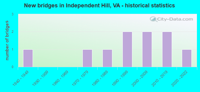
- New bridges - historical statistics
- 11940-1949
- 11970-1979
- 11980-1989
- 21990-1999
- 22000-2009
- 22010-2019
- 12020-2022


- Bridge Condition - Deck
- 20.0%Excellent
- 80.0%Good

- Bridge Condition - Superstructure
- 14.3%Excellent
- 85.7%Good

- Bridge Condition - Substructure
- 14.3%Excellent
- 57.1%Good
- 14.3%Satisfactory
- 14.3%Fair

- Bridge Condition - Channel
- 40.0%Good
- 20.0%Satisfactory
- 20.0%Fair
- 20.0%Poor

- Bridge Condition - Culverts
- 33.3%Good
- 66.7%Satisfactory
Find on map >> Show street view
Structure Number: 2VA00FF, Location: 1.2KM SOUTH OF SR-646 (Lat: 38.631100, Lng: -77.496769), Route carried "on" structure: Other road , Year Built: 1947, Year Reconstructed: 1993, Status: Open, Structure Length: 1.18m (3.87ft), Average Daily Traffic: 500 (year 2015), Truck Traffic: 10%, Average Future Daily Traffic: 600 (year 2039), Design Load: HS 20+Mod, Features Intersected: BRANCH OF CEDAR RUN, Facility Carried by Structure: MCB-8
Minimum Vertical Clearance: 30+ m (98+ ft), Kilometerpoint: 0.000, Lanes on structure: 2, Owner: Navy/Marines, Approaching Roadway Width: 6.0m (19.7ft), Material/Design: Prestressed concrete, Design/Construction: Slab, Number Of Spans In Main Unit: 1, Length of Maximum Span: 11.8m (38.7ft), Curb-To-Curb Width: 7.5m (24.6ft), Out-to-Out Width: 8.5m (27.9ft)
Condition: Deck: Good, Superstructure: Good, Substructure: Fair, Channel: Satisfactory, Operating Rating: 79.7 metric tons, Method Used To Determine Operating Rating: Load Factor (LF), Inventory Rating: 44.1 metric tons, Method Used To Determine Inventory Rating: Load Factor (LF), Structural Evaluation: Somewhat better than minimum adequacy, Deck Geometry: Meets minimum limits, Waterway Adequacy: Better than present minimum criteria, Approach Roadway Alignment: Equal to present minimum criteria, Length Of Structure Improvement: 1.18m (3.87ft), Designated Inspection Frequency: Every 24 months, Inspection Date: September 2021, Bridge Improvement Cost: $28,000, Roadway Improvement Cost: $14,000, Total Project Cost: $42,000 ( Estimate for 2021), Deck Structure Type: Concrete Precast Panels, Wearing Surface/Protective System: Wearing Surface: Bituminous
Find on map >> Show street view
Structure Number: 14403, Location: 00.45 1645 / 00.05 1434 (Lat: 38.666931, Lng: -77.453075), Route carried "on" structure: County highway 1435, Year Built: 1982, Status: Open, Structure Length: 0.76m (2.49ft), Average Daily Traffic: 293 (year 2010), Average Future Daily Traffic: 337 (year 2040), Design Load: HS 20, Features Intersected: TRIBUTARY OF OCCOQUAN RV, Facility Carried by Structure: WHITTING DRIVE
Minimum Vertical Clearance: 30+ m (98+ ft), Kilometerpoint: 0.637, Lanes on structure: 2, Owner: State Highway Agency, Approaching Roadway Width: 11.9m (39.0ft), Skew: 3 degrees, Material/Design: Steel, Design/Construction: Culvert, Number Of Spans In Main Unit: 4, Length of Maximum Span: 1.5m (4.9ft)
Condition: Channel: Poor, Culverts: Good, Operating Rating: 44.5 metric tons, Method Used To Determine Operating Rating: Load Factor (LF), Inventory Rating: 32.7 metric tons, Method Used To Determine Inventory Rating: Load Factor (LF), Structural Evaluation: Better than present minimum criteria, Waterway Adequacy: Equal to present minimum criteria, Approach Roadway Alignment: Equal to present desirable criteria, Length Of Structure Improvement: 1.07m (3.51ft), Designated Inspection Frequency: Every 24 months, Inspection Date: March 2020, Bridge Improvement Cost: $10,000, Roadway Improvement Cost: $5,000, Total Project Cost: $50,000
Find on map >> Show street view
Structure Number: 26059, Location: 0.41FR MEDOW & 0.15TO631 (Lat: 38.671953, Lng: -77.425700), Route carried "on" structure: County highway 3166, Year Built: 1999, Status: Open, Structure Length: 0.61m (2.00ft), Average Daily Traffic: 1,548 (year 2013), Average Future Daily Traffic: 1,757 (year 2040), Design Load: HS 20, Features Intersected: TRIB. OF PURCELL BRANCH, Facility Carried by Structure: CHAMPLAIN DRIVE
Minimum Vertical Clearance: 30+ m (98+ ft), Kilometerpoint: 0.000, Lanes on structure: 2, Owner: State Highway Agency, Approaching Roadway Width: 6.7m (22.0ft), Skew: 2 degrees, Material/Design: Concrete, Design/Construction: Arch - Deck, Number Of Spans In Main Unit: 1, Length of Maximum Span: 6.1m (20.0ft), Curb-To-Curb Width: 6.9m (22.6ft), Out-to-Out Width: 43.6m (143.0ft)
Condition: Deck: Good, Superstructure: Good, Substructure: Good, Channel: Good, Operating Rating: 56.5 metric tons, Method Used To Determine Operating Rating: Load and Resistance Factor (LRFR), Inventory Rating: 43.2 metric tons, Method Used To Determine Inventory Rating: Load and Resistance Factor (LRFR), Structural Evaluation: Better than present minimum criteria, Deck Geometry: High priority of corrective action, Waterway Adequacy: Better than present minimum criteria, Approach Roadway Alignment: Equal to present desirable criteria, Length Of Structure Improvement: 0.30m (0.98ft), Designated Inspection Frequency: Every 24 months, Inspection Date: September 2020, Bridge Improvement Cost: $1,000, Roadway Improvement Cost: $1,000, Total Project Cost: $3,000 ( Estimate for 2016)
Find on map >> Show street view
Structure Number: 2606, Location: 00.10fr234/00.08toBrookm (Lat: 38.669650, Lng: -77.436114), Route carried "on" structure: County highway 3150, Year Built: 1999, Status: Open, Structure Length: 0.67m (2.20ft), Average Daily Traffic: 1,823 (year 2008), Average Future Daily Traffic: 2,115 (year 2040), Design Load: HS 20, Features Intersected: PURCELL BRANCH, Facility Carried by Structure: MEADOWGATE DRIVE
Minimum Vertical Clearance: 30+ m (98+ ft), Kilometerpoint: 0.161, Lanes on structure: 2, Owner: State Highway Agency, Approaching Roadway Width: 15.8m (51.8ft), Material/Design: Concrete, Design/Construction: Culvert, Number Of Spans In Main Unit: 3, Length of Maximum Span: 1.8m (5.9ft)
Condition: Channel: Poor, Culverts: Satisfactory, Operating Rating: 89.8 metric tons, Method Used To Determine Operating Rating: Load Factor (LF), Inventory Rating: 89.7 metric tons, Method Used To Determine Inventory Rating: Load Factor (LF), Structural Evaluation: Equal to present minimum criteria, Waterway Adequacy: Better than present minimum criteria, Approach Roadway Alignment: Equal to present desirable criteria, Length Of Structure Improvement: 0.30m (0.98ft), Designated Inspection Frequency: Every 24 months, Inspection Date: June 2020, Bridge Improvement Cost: $1,000, Roadway Improvement Cost: $1,000, Total Project Cost: $3,000
Find on map >> Show street view
Structure Number: 27981, Location: 01.00FR640/0.40TO234 (Lat: 38.617333, Lng: -77.372375), Route carried "on" structure: Alternate County highway 643, Year Built: 2004, Status: Open, Structure Length: 2.38m (7.81ft), Average Daily Traffic: 9,674 (year 2020), Truck Traffic: 3%, Average Future Daily Traffic: 13,544 (year 2040), Design Load: HS 20, Features Intersected: POWELLS CREEK, Facility Carried by Structure: SPRIGGS ROAD
Minimum Vertical Clearance: 30+ m (98+ ft), Kilometerpoint: 0.000, Lanes on structure: 5, Owner: State Highway Agency, Approaching Roadway Width: 8.2m (26.9ft), Skew: 10 degrees, Material/Design: Prestressed concrete, Design/Construction: Stringer/Multi-beam, Number Of Spans In Main Unit: 1, Length of Maximum Span: 23.2m (76.1ft), Curb or Sidewalk Widths: Left: 3.4m (11.2ft), Right: 3.0m (9.8ft), Curb-To-Curb Width: 21.3m (69.9ft), Out-to-Out Width: 28.6m (93.8ft)
Condition: Deck: Good, Superstructure: Good, Substructure: Good, Channel: Good, Operating Rating: 69.2 metric tons, Method Used To Determine Operating Rating: Load and Resistance Factor (LRFR), Inventory Rating: 53.4 metric tons, Method Used To Determine Inventory Rating: Load and Resistance Factor (LRFR), Structural Evaluation: Better than present minimum criteria, Deck Geometry: Somewhat better than minimum adequacy, Approach Roadway Alignment: Superior to present desirable criteria, Length Of Structure Improvement: 2.38m (7.81ft), Designated Inspection Frequency: Every 24 months, Inspection Date: December 2020, Bridge Improvement Cost: $1,200,000, Roadway Improvement Cost: $300,000, Total Project Cost: $1,505,000, Deck Structure Type: Concrete Cast-file-Place, Wearing Surface/Protective System: Deck Protection: Epoxy Coated Reinforcing
Find on map >> Show street view
Structure Number: 28513, Location: 00.50FR2654/00.10TO HOLY (Lat: 38.643553, Lng: -77.402758), Route carried "on" structure: County highway 2662, Year Built: 2006, Status: Open, Structure Length: 1.10m (3.61ft), Average Daily Traffic: 345 (year 2013), Average Future Daily Traffic: 392 (year 2040), Design Load: HS 20, Features Intersected: TRIB.OF POWELLS CREEK, Facility Carried by Structure: PASSAGE CREEK LA.
Minimum Vertical Clearance: 30+ m (98+ ft), Kilometerpoint: 0.225, Lanes on structure: 2, Owner: State Highway Agency, Approaching Roadway Width: 6.1m (20.0ft), Material/Design: Concrete, Design/Construction: Culvert, Number Of Spans In Main Unit: 4, Length of Maximum Span: 2.4m (7.9ft)
Condition: Channel: Fair, Culverts: Satisfactory, Operating Rating: 89.8 metric tons, Method Used To Determine Operating Rating: Load Factor (LF), Inventory Rating: 63.5 metric tons, Method Used To Determine Inventory Rating: Load Factor (LF), Structural Evaluation: Equal to present minimum criteria, Waterway Adequacy: Better than present minimum criteria, Approach Roadway Alignment: Equal to present desirable criteria, Length Of Structure Improvement: 9.14m (29.99ft), Designated Inspection Frequency: Every 24 months, Inspection Date: May 2021, Bridge Improvement Cost: $54,000, Roadway Improvement Cost: $99,000, Total Project Cost: $175,000 ( Estimate for 2015)
Find on map >> Show street view
Structure Number: 29569, Location: 00.05FR0643/00.02TO0000 (Lat: 38.619953, Lng: -77.373094), Route carried "on" structure: County highway 3895, Year Built: 2010, Status: Open, Structure Length: 0.67m (2.20ft), Average Daily Traffic: 500 (year 2011), Average Future Daily Traffic: 2,000 (year 2035), Design Load: HS 20, Features Intersected: Trib of Powells Creek, Facility Carried by Structure: Hope Hill Ave
Minimum Vertical Clearance: 30.45m (99.90ft), Kilometerpoint: 0.000, Lanes on structure: 3, Owner: State Highway Agency, Approaching Roadway Width: 20.4m (66.9ft), Skew: 10 degrees, Material/Design: Concrete, Design/Construction: Arch - Deck, Number Of Spans In Main Unit: 1, Length of Maximum Span: 6.1m (20.0ft), Curb or Sidewalk Widths: Left: 1.5m (4.9ft), Right: 1.5m (4.9ft), Curb-To-Curb Width: 13.7m (44.9ft), Out-to-Out Width: 51.8m (169.9ft)
Condition: Superstructure: Good, Substructure: Good, Channel: Fair, Operating Rating: 84.4 metric tons, Method Used To Determine Operating Rating: Load Factor (LF), Inventory Rating: 60.8 metric tons, Method Used To Determine Inventory Rating: Load Factor (LF), Structural Evaluation: Better than present minimum criteria, Deck Geometry: Somewhat better than minimum adequacy, Waterway Adequacy: Equal to present desirable criteria, Approach Roadway Alignment: Equal to present desirable criteria, Designated Inspection Frequency: Every 24 months, Inspection Date: April 2021, Deck Structure Type: Concrete Precast Panels
Find on map >> Show street view
Structure Number: 30175, Location: 0.10fr2350 0.08to1436_ (Lat: 38.632417, Lng: -77.398000), Route carried "on" structure: Alternate County highway 640, Year Built: 2017, Status: Open, Structure Length: 1.95m (6.40ft), Average Daily Traffic: 8,887 (year 2017), Average Future Daily Traffic: 8,909 (year 2035), Design Load: HS 20+Mod, Features Intersected: POWELLS CREEK, Facility Carried by Structure: MINNIEVILLE ROAD
Minimum Vertical Clearance: 30.18m (99.02ft), Kilometerpoint: 0.000, Lanes on structure: 6, Owner: State Highway Agency, Approaching Roadway Width: 7.3m (24.0ft), Material/Design: Concrete, Design/Construction: Arch - Deck, Number Of Spans In Main Unit: 1, Length of Maximum Span: 16.5m (54.1ft), Curb-To-Curb Width: 11.0m (36.1ft), Out-to-Out Width: 59.1m (193.9ft)
Condition: Superstructure: Good, Substructure: Good, Channel: Good, Operating Rating: 79.6 metric tons, Method Used To Determine Operating Rating: Load and Resistance Factor (LRFR), Inventory Rating: 66.4 metric tons, Method Used To Determine Inventory Rating: Load and Resistance Factor (LRFR), Structural Evaluation: Better than present minimum criteria, Deck Geometry: High priority of replacement, Waterway Adequacy: Better than present minimum criteria, Approach Roadway Alignment: Better than present minimum criteria, Designated Inspection Frequency: Every 24 months, Inspection Date: October 2020
Find on map >> Show street view
Structure Number: 3145, Location: 03.60FR646/03.40TO620 (Lat: 38.587264, Lng: -77.428553), Route carried "on" structure: County highway 619, Year Built: 2021, Status: Open, Structure Length: 1.77m (5.81ft), Average Daily Traffic: 3,349 (year 2018), Truck Traffic: 2%, Average Future Daily Traffic: 3,729 (year 2035), Design Load: HL 93, Features Intersected: SOUTH FORK QUANTICO CK., Facility Carried by Structure: JOPLIN ROAD
Minimum Vertical Clearance: 30+ m (98+ ft), Kilometerpoint: 30.830, Lanes on structure: 2, Base Highway Network: Yes, Owner: State Highway Agency, Approaching Roadway Width: 5.8m (19.0ft), Material/Design: Prestressed concrete, Design/Construction: Slab, Number Of Spans In Main Unit: 1, Length of Maximum Span: 17.7m (58.1ft), Curb-To-Curb Width: 6.7m (22.0ft), Out-to-Out Width: 8.2m (26.9ft)
Condition: Deck: Excellent, Superstructure: Excellent, Substructure: Excellent, Channel: Good, Operating Rating: 74.7 metric tons, Method Used To Determine Operating Rating: Load and Resistance Factor (LRFR), Inventory Rating: 55.5 metric tons, Method Used To Determine Inventory Rating: Load and Resistance Factor (LRFR), Structural Evaluation: Superior to present desirable criteria, Deck Geometry: High priority of replacement, Waterway Adequacy: Better than present minimum criteria, Approach Roadway Alignment: Equal to present minimum criteria, Length Of Structure Improvement: 1.46m (4.79ft), Designated Inspection Frequency: Every 24 months, Inspection Date: March 2021, Bridge Improvement Cost: $270,000, Roadway Improvement Cost: $31,000, Total Project Cost: $325,000, Deck Structure Type: Concrete Precast Panels, Wearing Surface/Protective System: Wearing Surface: Monolithic Concrete, Deck Protection: Other
Find on map >> Show street view
Structure Number: 3700003P, Location: I-95 to Exit 150 (VA Rout (Lat: 38.576442, Lng: -77.379286), Route carried "on" structure: Federal lands road 11, Year Built: 1970, Status: Open, Structure Length: 1.83m (6.00ft), Average Daily Traffic: 460 (year 2020), Truck Traffic: 4%, Average Future Daily Traffic: 552 (year 2040), Design Load: H 15, Features Intersected: SOUTH FORK QUANTICO CREE, Facility Carried by Structure: SCENIC DRIVE
Minimum Vertical Clearance: 30+ m (98+ ft), Kilometerpoint: 14.050, Lanes on structure: 2, Owner: National Park Service, Approaching Roadway Width: 8.8m (28.9ft), Skew: 4 degrees, Material/Design: Concrete, Design/Construction: Slab, Number Of Spans In Main Unit: 2, Length of Maximum Span: 9.1m (29.9ft), Curb-To-Curb Width: 7.9m (25.9ft), Out-to-Out Width: 8.5m (27.9ft)
Condition: Deck: Good, Superstructure: Good, Substructure: Satisfactory, Channel: Satisfactory, Operating Rating: 49.9 metric tons, Method Used To Determine Operating Rating: Load Factor (LF), Inventory Rating: 29.9 metric tons, Method Used To Determine Inventory Rating: Load Factor (LF), Structural Evaluation: Equal to present minimum criteria, Waterway Adequacy: Equal to present desirable criteria, Approach Roadway Alignment: Equal to present desirable criteria, Designated Inspection Frequency: Every 24 months, Inspection Date: March 2021, Bridge Improvement Cost: $90,000, Roadway Improvement Cost: $9,000, Total Project Cost: $135,000 ( Estimate for 2020), Deck Structure Type: Concrete Cast-file-Place, Wearing Surface/Protective System: Wearing Surface: Monolithic Concrete