Bridge Statistics for Little Falls, New Jersey (NJ)
Condition, Traffic, Stress, Structural Evaluation, Project Costs
- National Bridge Inventory (NBI) Statistics
- 16Number of bridges
- 131ft / 39.9mTotal length
- $6,753,000Total costs
- 789,467Total average daily traffic
- 31,307Total average daily truck traffic
- National Bridge Inventory (NBI) Registered Bridges for Little Falls
- No street view available for this location
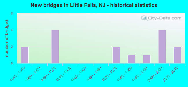
- New bridges - historical statistics
- 21910-1919
- 41930-1939
- 21970-1979
- 11980-1989
- 11990-1999
- 42000-2009
- 22010-2019

- Reconstructed bridges - Historical Statistics
- 21980-1989
- 11990-1999


- Bridge Condition - Deck
- 9.1%Excellent
- 45.5%Good
- 18.2%Satisfactory
- 18.2%Fair
- 9.1%Poor

- Bridge Condition - Superstructure
- 9.1%Excellent
- 18.2%Very good
- 18.2%Good
- 27.3%Satisfactory
- 27.3%Fair

- Bridge Condition - Substructure
- 9.1%Excellent
- 9.1%Very good
- 27.3%Good
- 36.4%Satisfactory
- 18.2%Fair

- Bridge Condition - Channel
- 33.3%Very good
- 16.7%Good
- 16.7%Satisfactory
- 33.3%Fair
Find on map >> Show street view
Structure Number: 760153, Location: 0.8 MI SE US46 & NJ3 JCT (Lat: 40.864100, Lng: -74.199800), Route carried "on" structure: City street , Year Built: 1970, Status: Open, Structure Length: 3.60m (11.81ft), Average Daily Traffic: 7,217 (year 2021), Truck Traffic: 1%, Average Future Daily Traffic: 8,806 (year 2041), Design Load: HS 20, Features Intersected: MONTCLAIR-BOONTON LINE, Facility Carried by Structure: YOGI BERRA DRIVE
Minimum Vertical Clearance: 30+ m (98+ ft), Kilometerpoint: 0.000, Lanes on structure: 2, Owner: State Agenciy, Approaching Roadway Width: 7.3m (24.0ft), Material/Design: Concrete, Design/Construction: Frame, Number Of Spans In Main Unit: 3, Length of Maximum Span: 18.3m (60.0ft), Curb or Sidewalk Widths: Left: 1.7m (5.6ft), Right: 1.7m (5.6ft), Curb-To-Curb Width: 7.3m (24.0ft), Out-to-Out Width: 12.5m (41.0ft)
Condition: Deck: Satisfactory, Superstructure: Fair, Substructure: Good, Operating Rating: 44.5 metric tons, Method Used To Determine Operating Rating: Allowable Stress (AS), Inventory Rating: 32.7 metric tons, Method Used To Determine Inventory Rating: Allowable Stress (AS), Structural Evaluation: Somewhat better than minimum adequacy, Deck Geometry: High priority of replacement, Underclear: Meets minimum limits, Approach Roadway Alignment: Somewhat better than minimum adequacy, Length Of Structure Improvement: 3.60m (11.81ft), Designated Inspection Frequency: Every 24 months, Inspection Date: Febuary 2021, Bridge Improvement Cost: $1,169,000, Roadway Improvement Cost: $117,000, Total Project Cost: $2,822,000 ( Estimate for 2021), Deck Structure Type: Concrete Precast Panels, Wearing Surface/Protective System: Wearing Surface: Bituminous, Membrane: Preformed Fabric
Find on map >> Show street view
Structure Number: 1600022, Location: 0.4 MI SW OF JCT US 46 (Lat: 40.883419, Lng: -74.233211), Route carried "on" structure: County highway 646, Year Built: 1995, Status: Open, Structure Length: 5.73m (18.80ft), Average Daily Traffic: 19,153 (year 2021), Truck Traffic: 4%, Average Future Daily Traffic: 23,371 (year 2041), Design Load: HS 20+Mod, Features Intersected: PASSAIC RIVER, Facility Carried by Structure: UNION AVENUE
Minimum Vertical Clearance: 30+ m (98+ ft), Kilometerpoint: 0.354, Lanes on structure: 2, Owner: County Highway Agency, Approaching Roadway Width: 14.0m (45.9ft), Material/Design: Steel, Design/Construction: Stringer/Multi-beam, Number Of Spans In Main Unit: 1, Length of Maximum Span: 56.4m (185.0ft), Curb or Sidewalk Widths: Left: 1.8m (5.9ft), Right: 1.8m (5.9ft), Curb-To-Curb Width: 14.0m (45.9ft), Out-to-Out Width: 18.3m (60.0ft)
Condition: Deck: Good, Superstructure: Good, Substructure: Good, Channel: Very good, Operating Rating: 81.6 metric tons, Method Used To Determine Operating Rating: Load Factor (LF), Inventory Rating: 49.0 metric tons, Method Used To Determine Inventory Rating: Load Factor (LF), Structural Evaluation: Better than present minimum criteria, Deck Geometry: Superior to present desirable criteria, Waterway Adequacy: Superior to present desirable criteria, Approach Roadway Alignment: Equal to present desirable criteria, Designated Inspection Frequency: Every 24 months, Inspection Date: May 2021, Deck Structure Type: Concrete Cast-file-Place, Wearing Surface/Protective System: Wearing Surface: Monolithic Concrete, Deck Protection: Epoxy Coated Reinforcing
Find on map >> Show street view
Structure Number: 1600132, Location: 0.7 MI. E OF JCT RT 23 (Lat: 40.878189, Lng: -74.219850), Route carried "on" structure: County highway 631, Year Built: 1913, Year Reconstructed: 1992, Status: Open, Structure Length: 2.47m (8.10ft), Average Daily Traffic: 14,395 (year 2021), Truck Traffic: 4%, Average Future Daily Traffic: 19,390 (year 2041), Design Load: HS 25 or greater, Features Intersected: PECKMAN RIVER
Minimum Vertical Clearance: 30+ m (98+ ft), Kilometerpoint: 3.251, Lanes on structure: 2, Owner: County Highway Agency, Approaching Roadway Width: 9.1m (29.9ft), Skew: 4 degrees, Material/Design: Prestressed concrete, Design/Construction: Slab, Number Of Spans In Main Unit: 2, Length of Maximum Span: 11.9m (39.0ft), Curb or Sidewalk Widths: Left: 1.5m (4.9ft), Right: 1.5m (4.9ft), Curb-To-Curb Width: 9.8m (32.2ft), Out-to-Out Width: 13.4m (44.0ft)
Condition: Deck: Fair, Superstructure: Fair, Substructure: Fair, Channel: Fair, Operating Rating: 53.5 metric tons, Method Used To Determine Operating Rating: Load Factor (LF), Inventory Rating: 32.7 metric tons, Method Used To Determine Inventory Rating: Load Factor (LF), Structural Evaluation: Somewhat better than minimum adequacy, Deck Geometry: Meets minimum limits, Waterway Adequacy: Superior to present desirable criteria, Approach Roadway Alignment: Equal to present desirable criteria, Designated Inspection Frequency: Every 24 months, Inspection Date: March 2021, Total Project Cost: $75,000 ( Estimate for 2021), Deck Structure Type: Concrete Precast Panels, Wearing Surface/Protective System: Wearing Surface: Bituminous, Membrane: Preformed Fabric
Find on map >> Show street view
Structure Number: 1600133, Location: 1.0 MI EAST OF NJ RT. 23 (Lat: 40.872139, Lng: -74.222250), Route carried "on" structure: County highway 612, Year Built: 1974, Status: Open, Structure Length: 1.55m (5.09ft), Average Daily Traffic: 6,460 (year 2021), Truck Traffic: 4%, Average Future Daily Traffic: 8,710 (year 2041), Design Load: HS 20, Features Intersected: PECKMAN RIVER, Facility Carried by Structure: FRANCISCO AVENUE
Minimum Vertical Clearance: 30+ m (98+ ft), Kilometerpoint: 0.274, Lanes on structure: 2, Owner: County Highway Agency, Approaching Roadway Width: 14.6m (47.9ft), Material/Design: Prestressed concrete, Design/Construction: Slab, Number Of Spans In Main Unit: 1, Length of Maximum Span: 14.9m (48.9ft), Curb or Sidewalk Widths: Left: 1.8m (5.9ft), Right: 1.8m (5.9ft), Curb-To-Curb Width: 14.0m (45.9ft), Out-to-Out Width: 18.3m (60.0ft)
Condition: Deck: Fair, Superstructure: Fair, Substructure: Satisfactory, Channel: Satisfactory, Operating Rating: 28.1 metric tons, Method Used To Determine Operating Rating: Load Factor (LF), Inventory Rating: 16.3 metric tons, Method Used To Determine Inventory Rating: Load Factor (LF), Structural Evaluation: Meets minimum limits, Deck Geometry: Superior to present desirable criteria, Waterway Adequacy: Superior to present desirable criteria, Approach Roadway Alignment: Equal to present minimum criteria, Designated Inspection Frequency: Every 24 months, Inspection Date: March 2021, Deck Structure Type: Concrete Cast-file-Place, Wearing Surface/Protective System: Wearing Surface: Bituminous, Membrane: Epoxy
Find on map >> Show street view
Structure Number: 160415, Location: 1.0 mi S of I-80 (Lat: 40.887461, Lng: -74.246281), Route carried "on" structure: State highway 23, Year Built: 1916, Year Reconstructed: 1988, Status: Open, Structure Length: 9.24m (30.31ft), Average Daily Traffic: 37,230 (year 2021), Truck Traffic: 4%, Average Future Daily Traffic: 44,675 (year 2041), Features Intersected: PASSAIC RIVER
Minimum Vertical Clearance: 30+ m (98+ ft), Kilometerpoint: 7.306, Lanes on structure: 4, Base Highway Network: Yes, Owner: State Highway Agency, Approaching Roadway Width: 13.4m (44.0ft), Material/Design: Concrete, Design/Construction: Arch - Deck, Number Of Spans In Main Unit: 3, Length of Maximum Span: 29.9m (98.1ft), Curb or Sidewalk Widths: Left: 1.8m (5.9ft), Right: 1.8m (5.9ft), Curb-To-Curb Width: 13.4m (44.0ft), Out-to-Out Width: 17.7m (58.1ft)
Condition: Deck: Satisfactory, Superstructure: Satisfactory, Substructure: Fair, Channel: Fair, Operating Rating: 53.5 metric tons, Method Used To Determine Operating Rating: Load Factor (LF), Inventory Rating: 31.8 metric tons, Method Used To Determine Inventory Rating: Load Factor (LF), Structural Evaluation: Somewhat better than minimum adequacy, Deck Geometry: High priority of replacement, Waterway Adequacy: Equal to present minimum criteria, Approach Roadway Alignment: Equal to present minimum criteria, Length Of Structure Improvement: 9.24m (30.31ft), Designated Inspection Frequency: Every 24 months, Underwater Inspection Frequency: Every 24 months, Inspection Date: July 2021, Underwater Inspection Date: September 2021, Bridge Improvement Cost: $582,000, Roadway Improvement Cost: $58,000, Total Project Cost: $940,000 ( Estimate for 2019), Deck Structure Type: Concrete Cast-file-Place, Wearing Surface/Protective System: Wearing Surface: Monolithic Concrete, Deck Protection: Epoxy Coated Reinforcing
Find on map >> Show street view
Structure Number: 1606159, Location: 1.7 MI. WEST OF JCT NJ 23 (Lat: 40.889281, Lng: -74.218900), Route carried "on" structure: US 46, Year Built: 1939, Year Reconstructed: 1997, Status: Open, Structure Length: 2.01m (6.59ft), Average Daily Traffic: 122,093 (year 2021), Truck Traffic: 4%, Average Future Daily Traffic: 146,511 (year 2041), Design Load: HS 25 or greater, Features Intersected: MCBRIDE AVENUE (CR 639)
Minimum Vertical Clearance: 30+ m (98+ ft), Kilometerpoint: 93.406, Lanes on structure: 8, Lanes under structure: 2, Base Highway Network: Yes, Owner: State Highway Agency, Approaching Roadway Width: 32.6m (107.0ft), Skew: 30 degrees, Material/Design: Steel, Design/Construction: Stringer/Multi-beam, Number Of Spans In Main Unit: 1, Length of Maximum Span: 18.9m (62.0ft), Curb or Sidewalk Widths: Left: 1.8m (5.9ft), Right: 0.0m, Curb-To-Curb Width: 32.8m (107.6ft), Out-to-Out Width: 36.3m (119.1ft)
Condition: Deck: Good, Superstructure: Very good, Substructure: Satisfactory, Operating Rating: 89.8 metric tons, Method Used To Determine Operating Rating: Load Factor (LF), Inventory Rating: 78.0 metric tons, Method Used To Determine Inventory Rating: Load Factor (LF), Structural Evaluation: Equal to present minimum criteria, Deck Geometry: Somewhat better than minimum adequacy, Underclear: Equal to present minimum criteria, Approach Roadway Alignment: Equal to present desirable criteria, Designated Inspection Frequency: Every 24 months, Inspection Date: April 2021, Deck Structure Type: Concrete Cast-file-Place, Wearing Surface/Protective System: Deck Protection: Epoxy Coated Reinforcing
Find on map >> Show street view
Structure Number: 160616, Location: 1.9 Mile West of RT 3 (Lat: 40.886369, Lng: -74.216219), Route carried "on" structure: US 46, Year Built: 2006, Status: Open, Structure Length: 2.07m (6.79ft), Average Daily Traffic: 144,450 (year 2020), Truck Traffic: 4%, Average Future Daily Traffic: 176,256 (year 2040), Design Load: HL 93, Features Intersected: PECKMAN'S BROOK
Minimum Vertical Clearance: 30+ m (98+ ft), Kilometerpoint: 93.809, Lanes on structure: 6, Base Highway Network: Yes, Owner: State Highway Agency, Approaching Roadway Width: 33.8m (110.9ft), Skew: 32 degrees, Material/Design: Prestressed concrete, Design/Construction: Box Beam or Girders - Single/Spread, Number Of Spans In Main Unit: 1, Length of Maximum Span: 19.2m (63.0ft), Curb or Sidewalk Widths: Left: 1.8m (5.9ft), Right: 1.8m (5.9ft), Curb-To-Curb Width: 33.4m (109.6ft), Out-to-Out Width: 39.6m (129.9ft)
Condition: Deck: Good, Superstructure: Very good, Substructure: Very good, Channel: Very good, Operating Rating: 63.5 metric tons, Method Used To Determine Operating Rating: Load and Resistance Factor Rating (LRFR) rating reported by rating factor(RF) method using HL-93 loadings, Inventory Rating: 48.9 metric tons, Method Used To Determine Inventory Rating: Load and Resistance Factor Rating (LRFR) rating reported by rating factor(RF) method using HL-93 loadings, Structural Evaluation: Equal to present desirable criteria, Deck Geometry: Superior to present desirable criteria, Waterway Adequacy: Equal to present minimum criteria, Approach Roadway Alignment: Equal to present desirable criteria, Designated Inspection Frequency: Every 24 months, Inspection Date: April 2020, Deck Structure Type: Concrete Cast-file-Place, Wearing Surface/Protective System: Wearing Surface: Latex Concrete, Deck Protection: Epoxy Coated Reinforcing
Find on map >> Show street view
Structure Number: 1606163, Location: 1.51MI. W. OF NJ 3 (Lat: 40.882231, Lng: -74.209931), Route carried "on" structure: US 46, Year Built: 2006, Status: Open, Structure Length: 2.10m (6.89ft), Average Daily Traffic: 124,427 (year 2021), Truck Traffic: 4%, Average Future Daily Traffic: 149,312 (year 2041), Design Load: HS 25 or greater, Features Intersected: BROWERTOWN RD (CR 635)
Minimum Vertical Clearance: 30+ m (98+ ft), Kilometerpoint: 94.517, Lanes on structure: 8, Lanes under structure: 2, Base Highway Network: Yes, Owner: State Highway Agency, Approaching Roadway Width: 39.6m (129.9ft), Skew: 31 degrees, Material/Design: Steel, Design/Construction: Stringer/Multi-beam, Number Of Spans In Main Unit: 1, Length of Maximum Span: 20.4m (66.9ft), Curb or Sidewalk Widths: Left: 1.8m (5.9ft), Right: 1.8m (5.9ft), Curb-To-Curb Width: 39.5m (129.6ft), Out-to-Out Width: 44.6m (146.3ft)
Condition: Deck: Good, Superstructure: Good, Substructure: Good, Inventory Rating: 82.6 metric tons, Method Used To Determine Inventory Rating: Load Factor (LF), Structural Evaluation: Better than present minimum criteria, Deck Geometry: Superior to present desirable criteria, Underclear: Equal to present minimum criteria, Approach Roadway Alignment: Equal to present desirable criteria, Designated Inspection Frequency: Every 24 months, Inspection Date: April 2021, Deck Structure Type: Concrete Cast-file-Place, Wearing Surface/Protective System: Deck Protection: Epoxy Coated Reinforcing
Find on map >> Show street view
Structure Number: 1606165, Location: 1.2 MILES WEST OF NJ 3 (Lat: 40.878969, Lng: -74.205350), Route carried "on" structure: US 46, Year Built: 1939, Status: Open, Structure Length: 1.58m (5.18ft), Average Daily Traffic: 124,421 (year 2021), Truck Traffic: 4%, Average Future Daily Traffic: 149,312 (year 2041), Features Intersected: LOWER NOTCH ROAD
Minimum Vertical Clearance: 30+ m (98+ ft), Kilometerpoint: 95.048, Lanes on structure: 8, Lanes under structure: 2, Base Highway Network: Yes, Owner: State Highway Agency, Approaching Roadway Width: 35.4m (116.1ft), Skew: 32 degrees, Material/Design: Steel, Design/Construction: Stringer/Multi-beam, Number Of Spans In Main Unit: 1, Length of Maximum Span: 14.6m (47.9ft), Curb or Sidewalk Widths: Left: 1.9m (6.2ft), Right: 1.9m (6.2ft), Curb-To-Curb Width: 34.7m (113.8ft), Out-to-Out Width: 39.7m (130.2ft)
Condition: Deck: Poor, Superstructure: Satisfactory, Substructure: Satisfactory, Operating Rating: 65.3 metric tons, Method Used To Determine Operating Rating: Load Factor (LF), Inventory Rating: 39.0 metric tons, Method Used To Determine Inventory Rating: Load Factor (LF), Structural Evaluation: Equal to present minimum criteria, Deck Geometry: Better than present minimum criteria, Underclear: High priority of corrective action, Approach Roadway Alignment: Equal to present desirable criteria, Length Of Structure Improvement: 1.58m (5.18ft), Designated Inspection Frequency: Every 24 months, Inspection Date: May 2021, Bridge Improvement Cost: $1,693,000, Roadway Improvement Cost: $512,000, Total Project Cost: $2,916,000 ( Estimate for 2021), Deck Structure Type: Concrete Cast-file-Place, Wearing Surface/Protective System: Wearing Surface: Bituminous
Find on map >> Show street view
Structure Number: 1606186, Location: 0.10 Mi West of US 46 Jct (Lat: 40.883069, Lng: -74.211639), Route carried "on" structure: Ramp US 46, Year Built: 2007, Status: Open, Structure Length: 1.10m (3.61ft), Average Daily Traffic: 5,610 (year 2021), Truck Traffic: 4%, Average Future Daily Traffic: 6,730 (year 2041), Design Load: HS 25 or greater, Features Intersected: GREAT NOTCH BROOK
Minimum Vertical Clearance: 30+ m (98+ ft), Kilometerpoint: 94.983, Lanes on structure: 1, Owner: State Highway Agency, Approaching Roadway Width: 7.0m (23.0ft), Skew: 4 degrees, Material/Design: Concrete, Design/Construction: Culvert, Number Of Spans In Main Unit: 2, Length of Maximum Span: 4.9m (16.1ft), Curb-To-Curb Width: 10.0m (32.8ft), Out-to-Out Width: 11.1m (36.4ft)
Condition: Channel: Good, Culverts: Good, Operating Rating: 89.8 metric tons, Method Used To Determine Operating Rating: Field evaluation and documented engineering judgment, Inventory Rating: 40.8 metric tons, Method Used To Determine Inventory Rating: Field evaluation and documented engineering judgment, Structural Evaluation: Better than present minimum criteria, Deck Geometry: Superior to present desirable criteria, Waterway Adequacy: Equal to present desirable criteria, Approach Roadway Alignment: Better than present minimum criteria, Designated Inspection Frequency: Every 24 months, Inspection Date: March 2021
Find on map >> Show street view
Structure Number: 1606187, Location: 0.5 MI west of JCT RT 3. (Lat: 40.873061, Lng: -74.195931), Route carried "on" structure: County highway 620, Year Built: 2019, Status: Open, Structure Length: 5.18m (16.99ft), Average Daily Traffic: 4,524 (year 2021), Truck Traffic: 4%, Average Future Daily Traffic: 5,429 (year 2041), Design Load: HL 93, Features Intersected: US 46
Minimum Vertical Clearance: 30+ m (98+ ft), Kilometerpoint: 1.400, Lanes on structure: 2, Lanes under structure: 7, Owner: State Highway Agency, Approaching Roadway Width: 9.8m (32.2ft), Material/Design: Steel, Design/Construction: Stringer/Multi-beam, Number Of Spans In Main Unit: 1, Length of Maximum Span: 50.3m (165.0ft), Curb or Sidewalk Widths: Left: 1.8m (5.9ft), Right: 0.0m, Curb-To-Curb Width: 9.8m (32.2ft), Out-to-Out Width: 12.4m (40.7ft)
Condition: Deck: Excellent, Superstructure: Excellent, Substructure: Excellent, Operating Rating: 57.0 metric tons, Method Used To Determine Operating Rating: Load and Resistance Factor Rating (LRFR) rating reported by rating factor(RF) method using HL-93 loadings, Inventory Rating: 44.1 metric tons, Method Used To Determine Inventory Rating: Load and Resistance Factor Rating (LRFR) rating reported by rating factor(RF) method using HL-93 loadings, Structural Evaluation: Superior to present desirable criteria, Deck Geometry: Meets minimum limits, Underclear: Better than present minimum criteria, Approach Roadway Alignment: Better than present minimum criteria, Designated Inspection Frequency: Every 24 months, Inspection Date: October 2021, Deck Structure Type: Concrete Cast-file-Place, Wearing Surface/Protective System: Wearing Surface: Monolithic Concrete, Deck Protection: Epoxy Coated Reinforcing
Find on map >> Show street view
Structure Number: 1662151, Location: 0.3 MI SW US46&CR631 JCT (Lat: 40.873439, Lng: -74.206719), Route carried "on" structure: County highway 631, Year Built: 1984, Status: Open, Structure Length: 3.23m (10.60ft), Average Daily Traffic: 9,586 (year 2021), Truck Traffic: 4%, Average Future Daily Traffic: 11,697 (year 2041), Design Load: HS 20+Mod, Features Intersected: MONTCLAIR-BOONTON LINE
Minimum Vertical Clearance: 30+ m (98+ ft), Kilometerpoint: 4.490, Lanes on structure: 4, Owner: State Agenciy, Approaching Roadway Width: 15.8m (51.8ft), Material/Design: Prestressed concrete, Design/Construction: Slab, Number Of Spans In Main Unit: 3, Length of Maximum Span: 15.5m (50.9ft), Curb or Sidewalk Widths: Left: 1.8m (5.9ft), Right: 1.8m (5.9ft), Curb-To-Curb Width: 15.2m (49.9ft), Out-to-Out Width: 19.5m (64.0ft)
Condition: Deck: Good, Superstructure: Satisfactory, Substructure: Satisfactory, Operating Rating: 82.6 metric tons, Method Used To Determine Operating Rating: Load Factor (LF), Inventory Rating: 49.9 metric tons, Method Used To Determine Inventory Rating: Load Factor (LF), Structural Evaluation: Equal to present minimum criteria, Deck Geometry: High priority of corrective action, Underclear: Better than present minimum criteria, Approach Roadway Alignment: Equal to present minimum criteria, Designated Inspection Frequency: Every 24 months, Inspection Date: Febuary 2021, Deck Structure Type: Concrete Cast-file-Place, Wearing Surface/Protective System: Wearing Surface: Monolithic Concrete, Deck Protection: Epoxy Coated Reinforcing
Find on map >> Show street view
Structure Number: 1606159, Location: 1.7 MI. WEST OF JCT NJ 23 (Lat: 40.889281, Lng: -74.218900), Route carried "under" structure: County highway 639, Year Built: 1939, Structure Length: 0. m, Average Daily Traffic: 8,822 (year 2021), Truck Traffic: 4%, Features Intersected: MCBRIDE AVENUE (CR 639), Facility Carried by Structure: US 46
Minimum Vertical Clearance: 4.75m (15.58ft), Kilometerpoint: 1.159, Lanes on structure: 8, Lanes under structure: 2, Material/Design: Steel, Design/Construction: Stringer/Multi-beam, Length of Maximum Span: 18.9m (62.0ft)
Find on map >> Show street view
Structure Number: 1606163, Location: 1.51MI. W. OF NJ 3 (Lat: 40.882231, Lng: -74.209931), Route carried "under" structure: County highway 635, Year Built: 2006, Structure Length: 0. m, Average Daily Traffic: 14,827 (year 2021), Truck Traffic: 4%, Features Intersected: BROWERTOWN RD (CR 635), Facility Carried by Structure: US 46
Minimum Vertical Clearance: 4.84m (15.88ft), Kilometerpoint: 0.805, Lanes on structure: 8, Lanes under structure: 2, Material/Design: Steel, Design/Construction: Stringer/Multi-beam, Length of Maximum Span: 20.4m (66.9ft)
Find on map >> Show street view
Structure Number: 1606165, Location: 1.2 MILES WEST OF NJ 3 (Lat: 40.878969, Lng: -74.205350), Route carried "under" structure: City street , Year Built: 1939, Structure Length: 0. m, Average Daily Traffic: 4,847 (year 2021), Truck Traffic: 3%, Features Intersected: LOWER NOTCH ROAD, Facility Carried by Structure: US 46
Minimum Vertical Clearance: 4.22m (13.85ft), Kilometerpoint: 0.885, Lanes on structure: 8, Lanes under structure: 2, Material/Design: Steel, Design/Construction: Stringer/Multi-beam, Length of Maximum Span: 14.6m (47.9ft)
Find on map >> Show street view
Structure Number: 1606187, Location: 0.5 MI west of JCT RT 3. (Lat: 40.873061, Lng: -74.195931), Route carried "under" structure: US 46, Year Built: 2019, Structure Length: 0. m, Average Daily Traffic: 141,405 (year 2021), Truck Traffic: 4%, Features Intersected: US 46, Facility Carried by Structure: Clove Road (CR620)
Minimum Vertical Clearance: 4.98m (16.34ft), Kilometerpoint: 96.062, Lanes on structure: 2, Lanes under structure: 7, Material/Design: Steel, Design/Construction: Stringer/Multi-beam, Length of Maximum Span: 50.3m (165.0ft)