Bridge Statistics for New Brighton, Minnesota (MN)
Condition, Traffic, Stress, Structural Evaluation, Project Costs
- National Bridge Inventory (NBI) Statistics
- 22Number of bridges
- 226ft / 69.5mTotal length
- $2,871,998,000Total costs
- 774,569Total average daily traffic
- 51,224Total average daily truck traffic
- National Bridge Inventory (NBI) Registered Bridges for New Brighton
- No street view available for this location
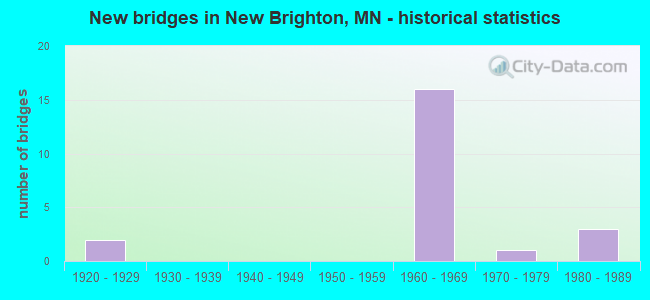
- New bridges - historical statistics
- 21920-1929
- 161960-1969
- 11970-1979
- 31980-1989


- Bridge Condition - Deck
- 54.5%Good
- 36.4%Satisfactory
- 9.1%Fair

- Bridge Condition - Superstructure
- 27.3%Good
- 45.5%Satisfactory
- 9.1%Fair
- 18.2%Poor

- Bridge Condition - Substructure
- 27.3%Good
- 18.2%Satisfactory
- 54.5%Fair

- Bridge Condition - Channel
- 42.9%Good
- 28.6%Satisfactory
- 28.6%Fair

- Bridge Condition - Culverts
- 80.0%Satisfactory
- 20.0%Fair
Find on map >> Show street view
Structure Number: 4513, Location: 1.6 MI NW OF JCT CSAH 33 (Lat: 47.438111, Lng: -94.671967), Route carried "on" structure: County highway 8, Year Built: 1986, Status: Open, Structure Length: 9.31m (30.54ft), Average Daily Traffic: 1,600 (year 2014), Average Future Daily Traffic: 1,600 (year 2039), Design Load: HS 20, Features Intersected: MISSISSIPPI RIVER
Minimum Vertical Clearance: 30+ m (98+ ft), Kilometerpoint: 0.000, Lanes on structure: 2, Owner: County Highway Agency, Approaching Roadway Width: 12.2m (40.0ft), Material/Design: Prestressed concrete, Design/Construction: Stringer/Multi-beam, Number Of Spans In Main Unit: 3, Length of Maximum Span: 30.5m (100.1ft), Curb-To-Curb Width: 12.2m (40.0ft), Out-to-Out Width: 13.2m (43.3ft)
Condition: Deck: Good, Superstructure: Good, Substructure: Good, Channel: Good, Operating Rating: 48.6 metric tons, Method Used To Determine Operating Rating: Load and Resistance Factor Rating (LRFR) rating reported by rating factor(RF) method using HL-93 loadings, Inventory Rating: 37.6 metric tons, Method Used To Determine Inventory Rating: Load and Resistance Factor Rating (LRFR) rating reported by rating factor(RF) method using HL-93 loadings, Structural Evaluation: Better than present minimum criteria, Deck Geometry: Better than present minimum criteria, Waterway Adequacy: Equal to present desirable criteria, Approach Roadway Alignment: Better than present minimum criteria, Designated Inspection Frequency: Every 24 months, Underwater Inspection Frequency: Every 60 months, Inspection Date: September 2020, Underwater Inspection Date: September 2020, Deck Structure Type: Concrete Cast-file-Place, Wearing Surface/Protective System: Wearing Surface: Monolithic Concrete, Deck Protection: Epoxy Coated Reinforcing
Find on map >> Show street view
Structure Number: 4513, Location: 0.2 MI N OF JCT CSAH 11 (Lat: 45.084492, Lng: -93.211569), Route carried "on" structure: County highway 45, Year Built: 1926, Status: Open, Structure Length: 1.43m (4.69ft), Average Daily Traffic: 5,200 (year 2016), Average Future Daily Traffic: 5,200 (year 2039), Design Load: HS 20, Features Intersected: RICE CREEK
Minimum Vertical Clearance: 30+ m (98+ ft), Kilometerpoint: 0.000, Lanes on structure: 2, Owner: County Highway Agency, Approaching Roadway Width: 13.4m (44.0ft), Material/Design: Concrete, Design/Construction: Girder and Floorbeam System, Number Of Spans In Main Unit: 1, Length of Maximum Span: 13.7m (44.9ft), Curb or Sidewalk Widths: Left: 0.0m, Right: 1.8m (5.9ft), Curb-To-Curb Width: 13.4m (44.0ft), Out-to-Out Width: 16.1m (52.8ft)
Condition: Deck: Satisfactory, Superstructure: Satisfactory, Substructure: Good, Channel: Good, Operating Rating: 50.2 metric tons, Method Used To Determine Operating Rating: Load Factor (LF), Inventory Rating: 30.0 metric tons, Method Used To Determine Inventory Rating: Load Factor (LF), Structural Evaluation: Equal to present minimum criteria, Deck Geometry: Equal to present minimum criteria, Waterway Adequacy: Equal to present desirable criteria, Approach Roadway Alignment: Equal to present minimum criteria, Length Of Structure Improvement: 0.61m (2.00ft), Designated Inspection Frequency: Every 24 months, Inspection Date: September 2020, Bridge Improvement Cost: $287,000,000, Roadway Improvement Cost: $15,000,000, Total Project Cost: $235,000,000, Deck Structure Type: Concrete Cast-file-Place, Wearing Surface/Protective System: Wearing Surface: Low Slump Concrete
Find on map >> Show street view
Structure Number: 4533, Location: 0.2 MI E OF JCT CSAH 45 (Lat: 45.060136, Lng: -93.195397), Route carried "on" structure: County highway 77, Year Built: 1926, Status: Posted for load, Structure Length: 2.01m (6.59ft), Average Daily Traffic: 5,800 (year 2016), Average Future Daily Traffic: 5,800 (year 2039), Design Load: HS 20, Features Intersected: MC RY
Minimum Vertical Clearance: 30+ m (98+ ft), Kilometerpoint: 0.000, Lanes on structure: 4, Owner: County Highway Agency, Approaching Roadway Width: 13.1m (43.0ft), Material/Design: Prestressed concrete, Design/Construction: Channel Beam, Number Of Spans In Main Unit: 3, Length of Maximum Span: 6.7m (22.0ft), Curb or Sidewalk Widths: Left: 1.4m (4.6ft), Right: 1.4m (4.6ft), Curb-To-Curb Width: 15.9m (52.2ft), Out-to-Out Width: 19.4m (63.6ft)
Condition: Deck: Good, Superstructure: Poor, Substructure: Fair, Operating Rating: 68.9 metric tons, Method Used To Determine Operating Rating: Load Factor (LF), Inventory Rating: 41.5 metric tons, Method Used To Determine Inventory Rating: Load Factor (LF), Structural Evaluation: Meets minimum limits, Deck Geometry: Meets minimum limits, Underclear: High priority of corrective action, Approach Roadway Alignment: Equal to present minimum criteria, Bridge Posting: Required (Relationship of Operating Rating to Maximum Legal Load: 30.0 - 39.9% below), Length Of Structure Improvement: 0.73m (2.40ft), Designated Inspection Frequency: Every 12 months, Inspection Date: November 2021, Bridge Improvement Cost: $635,000,000, Roadway Improvement Cost: $35,000,000, Total Project Cost: $535,000,000, Deck Structure Type: Concrete Precast Panels, Wearing Surface/Protective System: Wearing Surface: Bituminous
Find on map >> Show street view
Structure Number: 62516, Location: 0.3 MI N OF JCT CSAH 11 (Lat: 45.088422, Lng: -93.218933), Route carried "on" structure: County highway 44, Year Built: 1965, Status: Open, Structure Length: 1.02m (3.35ft), Average Daily Traffic: 10,300 (year 2016), Average Future Daily Traffic: 10,300 (year 2039), Features Intersected: RICE CREEK
Minimum Vertical Clearance: 30+ m (98+ ft), Kilometerpoint: 0.000, Lanes on structure: 4, Owner: County Highway Agency, Approaching Roadway Width: 17.1m (56.1ft), Material/Design: Concrete, Design/Construction: Culvert, Number Of Spans In Main Unit: 3, Length of Maximum Span: 3.0m (9.8ft), Curb or Sidewalk Widths: Left: 1.5m (4.9ft), Right: 1.5m (4.9ft)
Condition: Channel: Satisfactory, Culverts: Satisfactory, Operating Rating: 39.2 metric tons, Method Used To Determine Operating Rating: Assigned ratings based on Allowable Stress Design (ASD) reported in metric tons, Inventory Rating: 29.4 metric tons, Method Used To Determine Inventory Rating: Assigned ratings based on Allowable Stress Design (ASD) reported in metric tons, Structural Evaluation: Equal to present minimum criteria, Waterway Adequacy: Equal to present desirable criteria, Approach Roadway Alignment: Equal to present desirable criteria, Length Of Structure Improvement: 0.49m (1.61ft), Designated Inspection Frequency: Every 24 months, Inspection Date: September 2021, Bridge Improvement Cost: $160,000,000, Roadway Improvement Cost: $4,000,000, Total Project Cost: $63,000,000
Find on map >> Show street view
Structure Number: 62522, Location: 0.4 MI N OF JCT TH 694 (Lat: 45.071217, Lng: -93.205428), Route carried "on" structure: County highway 45, Year Built: 1967, Status: Open, Structure Length: 0.69m (2.26ft), Average Daily Traffic: 7,600 (year 2016), Average Future Daily Traffic: 7,600 (year 2039), Design Load: H 20, Features Intersected: CO DITCH # 2
Minimum Vertical Clearance: 30+ m (98+ ft), Kilometerpoint: 0.000, Lanes on structure: 2, Owner: County Highway Agency, Approaching Roadway Width: 15.2m (49.9ft), Skew: 1 degrees, Material/Design: Concrete, Design/Construction: Culvert, Number Of Spans In Main Unit: 2, Length of Maximum Span: 3.1m (10.2ft)
Condition: Channel: Good, Culverts: Satisfactory, Operating Rating: 39.2 metric tons, Method Used To Determine Operating Rating: Assigned ratings based on Allowable Stress Design (ASD) reported in metric tons, Inventory Rating: 29.4 metric tons, Method Used To Determine Inventory Rating: Assigned ratings based on Allowable Stress Design (ASD) reported in metric tons, Structural Evaluation: Equal to present minimum criteria, Waterway Adequacy: Equal to present desirable criteria, Approach Roadway Alignment: Better than present minimum criteria, Designated Inspection Frequency: Every 24 months, Inspection Date: October 2021
Find on map >> Show street view
Structure Number: 62828, Location: 0.8 MI W OF JCT TH 35W (Lat: 45.065417, Lng: -93.202211), Route carried "on" structure: County highway 45, Year Built: 1989, Status: Open, Structure Length: 6.09m (19.98ft), Average Daily Traffic: 7,600 (year 2016), Average Future Daily Traffic: 7,600 (year 2039), Design Load: HS 25 or greater, Features Intersected: I 694
Minimum Vertical Clearance: 30+ m (98+ ft), Kilometerpoint: 0.000, Lanes on structure: 4, Lanes under structure: 6, Owner: State Highway Agency, Approaching Roadway Width: 21.3m (69.9ft), Skew: 21 degrees, Material/Design: Steel continuous, Design/Construction: Stringer/Multi-beam, Number Of Spans In Main Unit: 2, Length of Maximum Span: 30.5m (100.1ft), Curb or Sidewalk Widths: Left: 0.0m, Right: 1.8m (5.9ft), Curb-To-Curb Width: 19.5m (64.0ft), Out-to-Out Width: 24.0m (78.7ft)
Condition: Deck: Good, Superstructure: Good, Substructure: Fair, Operating Rating: 96.8 metric tons, Method Used To Determine Operating Rating: Load Factor (LF), Inventory Rating: 58.0 metric tons, Method Used To Determine Inventory Rating: Load Factor (LF), Structural Evaluation: Somewhat better than minimum adequacy, Deck Geometry: Better than present minimum criteria, Underclear: Equal to present minimum criteria, Approach Roadway Alignment: Equal to present desirable criteria, Designated Inspection Frequency: Every 24 months, Inspection Date: July 2021, Deck Structure Type: Concrete Cast-file-Place, Wearing Surface/Protective System: Wearing Surface: Low Slump Concrete, Deck Protection: Epoxy Coated Reinforcing
Find on map >> Show street view
Structure Number: 92876, Location: 0.1 MI E OF SILVER LK RD (Lat: 45.086144, Lng: -93.216972), Route carried "on" structure: City street 101, Year Built: 1971, Status: Open, Structure Length: 1.47m (4.82ft), Average Daily Traffic: 1,900 (year 2017), Average Future Daily Traffic: 1,900 (year 2039), Design Load: HS 20, Features Intersected: RICE CREEK
Minimum Vertical Clearance: 30+ m (98+ ft), Kilometerpoint: 0.000, Lanes on structure: 2, Owner: City or Municipal Highway Agency, Approaching Roadway Width: 13.4m (44.0ft), Skew: 2 degrees, Material/Design: Concrete, Design/Construction: Culvert, Number Of Spans In Main Unit: 3, Length of Maximum Span: 3.9m (12.8ft), Curb or Sidewalk Widths: Left: 1.5m (4.9ft), Right: 0.0m
Condition: Channel: Satisfactory, Culverts: Satisfactory, Operating Rating: 53.9 metric tons, Method Used To Determine Operating Rating: Assigned ratings based on Allowable Stress Design (ASD) reported in metric tons, Inventory Rating: 35.9 metric tons, Method Used To Determine Inventory Rating: Assigned ratings based on Allowable Stress Design (ASD) reported in metric tons, Structural Evaluation: Equal to present minimum criteria, Waterway Adequacy: Better than present minimum criteria, Approach Roadway Alignment: Better than present minimum criteria, Designated Inspection Frequency: Every 48 months, Inspection Date: August 2018
Find on map >> Show street view
Structure Number: 93532, Location: 0.1 MI W OF JCT CSAH 77 (Lat: 45.051083, Lng: -93.199508), Route carried "on" structure: County highway 15, Year Built: 1968, Status: Open, Structure Length: 0.73m (2.40ft), Average Daily Traffic: 6,300 (year 2016), Average Future Daily Traffic: 6,300 (year 2039), Design Load: HS 20, Features Intersected: CO DITCH # 2
Minimum Vertical Clearance: 30+ m (98+ ft), Kilometerpoint: 0.000, Lanes on structure: 2, Owner: County Highway Agency, Approaching Roadway Width: 9.8m (32.2ft), Skew: 3 degrees, Material/Design: Concrete, Design/Construction: Culvert, Number Of Spans In Main Unit: 4, Length of Maximum Span: 1.4m (4.6ft)
Condition: Channel: Fair, Culverts: Fair, Operating Rating: 39.2 metric tons, Method Used To Determine Operating Rating: Field evaluation and documented engineering judgment, Inventory Rating: 29.4 metric tons, Method Used To Determine Inventory Rating: Field evaluation and documented engineering judgment, Structural Evaluation: Somewhat better than minimum adequacy, Waterway Adequacy: Equal to present desirable criteria, Approach Roadway Alignment: Equal to present desirable criteria, Length Of Structure Improvement: 0.37m (1.21ft), Designated Inspection Frequency: Every 24 months, Inspection Date: October 2021, Bridge Improvement Cost: $77,000,000, Roadway Improvement Cost: $1,000,000, Total Project Cost: $18,000,000
Find on map >> Show street view
Structure Number: 93533, Location: 0.1 MI S OF JCT CSAH 15 (Lat: 45.051075, Lng: -93.199508), Route carried "on" structure: County highway 77, Year Built: 1968, Status: Open, Structure Length: 0.70m (2.30ft), Average Daily Traffic: 10,400 (year 2016), Average Future Daily Traffic: 10,400 (year 2039), Design Load: HS 20, Features Intersected: CO DITCH # 2
Minimum Vertical Clearance: 30+ m (98+ ft), Kilometerpoint: 0.000, Lanes on structure: 2, Owner: County Highway Agency, Approaching Roadway Width: 10.7m (35.1ft), Skew: 8 degrees, Material/Design: Concrete, Design/Construction: Culvert, Number Of Spans In Main Unit: 3, Length of Maximum Span: 1.7m (5.6ft)
Condition: Channel: Fair, Culverts: Satisfactory, Operating Rating: 39.2 metric tons, Method Used To Determine Operating Rating: Assigned ratings based on Allowable Stress Design (ASD) reported in metric tons, Inventory Rating: 29.4 metric tons, Method Used To Determine Inventory Rating: Assigned ratings based on Allowable Stress Design (ASD) reported in metric tons, Structural Evaluation: Equal to present minimum criteria, Waterway Adequacy: Equal to present desirable criteria, Approach Roadway Alignment: Equal to present desirable criteria, Length Of Structure Improvement: 0.34m (1.12ft), Designated Inspection Frequency: Every 24 months, Inspection Date: October 2021, Bridge Improvement Cost: $74,000,000, Roadway Improvement Cost: $1,000,000, Total Project Cost: $21,000,000
Find on map >> Show street view
Structure Number: 9357, Location: 0.7 MI N OF JCT TH 88 (Lat: 45.050292, Lng: -93.188653), Route carried "on" structure: , Year Built: 1963, Status: Open, Structure Length: 4.51m (14.80ft), Features Intersected: I 35W, Facility Carried by Structure: RAILROAD
Lanes under structure: 6, Owner: State Highway Agency, Material/Design: Steel, Design/Construction: Stringer/Multi-beam, Number Of Spans In Main Unit: 2, Length of Maximum Span: 22.1m (72.5ft), Curb or Sidewalk Widths: Left: 0.9m (3.0ft), Right: 0.9m (3.0ft), Out-to-Out Width: 14.6m (47.9ft)
Condition: Deck: Good, Superstructure: Fair, Substructure: Satisfactory, Underclear: Somewhat better than minimum adequacy, Bridge Posting: Required (Relationship of Operating Rating to Maximum Legal Load: > 39.9% below), Designated Inspection Frequency: Every 24 months, Inspection Date: April 2021, Deck Structure Type: Steel plate
Find on map >> Show street view
Structure Number: 9389, Location: 0.4 MI W OF JCT TH 35W (Lat: 45.066669, Lng: -93.193169), Route carried "on" structure: County highway 77, Year Built: 1964, Status: Open, Structure Length: 5.97m (19.59ft), Average Daily Traffic: 9,000 (year 2016), Average Future Daily Traffic: 9,000 (year 2039), Design Load: HS 20, Features Intersected: I 694
Minimum Vertical Clearance: 30+ m (98+ ft), Kilometerpoint: 0.000, Lanes on structure: 4, Lanes under structure: 6, Owner: State Highway Agency, Approaching Roadway Width: 37.2m (122.0ft), Material/Design: Steel continuous, Design/Construction: Stringer/Multi-beam, Number Of Spans In Main Unit: 4, Length of Maximum Span: 20.5m (67.3ft), Curb or Sidewalk Widths: Left: 1.5m (4.9ft), Right: 0.0m, Curb-To-Curb Width: 14.6m (47.9ft), Out-to-Out Width: 17.3m (56.8ft)
Condition: Deck: Satisfactory, Superstructure: Good, Substructure: Fair, Operating Rating: 57.1 metric tons, Method Used To Determine Operating Rating: Load Factor (LF), Inventory Rating: 34.3 metric tons, Method Used To Determine Inventory Rating: Load Factor (LF), Structural Evaluation: Somewhat better than minimum adequacy, Deck Geometry: High priority of replacement, Underclear: Equal to present minimum criteria, Approach Roadway Alignment: Better than present minimum criteria, Length Of Structure Improvement: 2.01m (6.59ft), Designated Inspection Frequency: Every 24 months, Inspection Date: July 2021, Bridge Improvement Cost: $999,999,000, Roadway Improvement Cost: $86,000,000, Total Project Cost: $999,999,000, Deck Structure Type: Concrete Cast-file-Place, Wearing Surface/Protective System: Wearing Surface: Low Slump Concrete
Find on map >> Show street view
Structure Number: 939, Location: 0.5 MI W OF JCT TH 35W (Lat: 45.066578, Lng: -93.195289), Route carried "on" structure: , Year Built: 1964, Status: Open, Structure Length: 6.38m (20.93ft), Features Intersected: I 694, Facility Carried by Structure: RAILROAD
Lanes under structure: 6, Owner: State Highway Agency, Skew: 1 degrees, Material/Design: Steel, Design/Construction: Girder and Floorbeam System, Number Of Spans In Main Unit: 4, Length of Maximum Span: 20.9m (68.6ft), Out-to-Out Width: 6.1m (20.0ft)
Condition: Deck: Good, Superstructure: Satisfactory, Substructure: Good, Underclear: Somewhat better than minimum adequacy, Bridge Posting: Required (Relationship of Operating Rating to Maximum Legal Load: > 39.9% below), Designated Inspection Frequency: Every 12 months, Inspection Date: May 2021
Find on map >> Show street view
Structure Number: 9473, Location: 0.1 MI SW OF JCT TH 35W (Lat: 45.039878, Lng: -93.191344), Route carried "on" structure: State highway 88, Year Built: 1963, Status: Open, Structure Length: 6.10m (20.01ft), Average Daily Traffic: 4,200 (year 2019), Truck Traffic: 7%, Average Future Daily Traffic: 4,000 (year 2039), Design Load: HS 20, Features Intersected: MC RAIL (COUNTY 88)
Minimum Vertical Clearance: 30+ m (98+ ft), Kilometerpoint: 0.000, Lanes on structure: 2, Owner: State Highway Agency, Approaching Roadway Width: 11.3m (37.1ft), Skew: 5 degrees, Material/Design: Steel continuous, Design/Construction: Stringer/Multi-beam, Number Of Spans In Main Unit: 3, Length of Maximum Span: 21.9m (71.9ft), Curb-To-Curb Width: 9.8m (32.2ft), Out-to-Out Width: 10.8m (35.4ft)
Condition: Deck: Good, Superstructure: Satisfactory, Substructure: Satisfactory, Operating Rating: 63.7 metric tons, Method Used To Determine Operating Rating: Load Factor (LF), Inventory Rating: 38.2 metric tons, Method Used To Determine Inventory Rating: Load Factor (LF), Structural Evaluation: Equal to present minimum criteria, Deck Geometry: Meets minimum limits, Underclear: Somewhat better than minimum adequacy, Approach Roadway Alignment: Equal to present desirable criteria, Designated Inspection Frequency: Every 24 months, Inspection Date: April 2020, Deck Structure Type: Concrete Cast-file-Place, Wearing Surface/Protective System: Wearing Surface: Low Slump Concrete
Find on map >> Show street view
Structure Number: 9474, Location: 0.1 MI SW OF JCT TH35W (Lat: 45.039528, Lng: -93.191422), Route carried "on" structure: State highway 88, Year Built: 1963, Status: Open, Structure Length: 5.16m (16.93ft), Average Daily Traffic: 4,200 (year 2019), Truck Traffic: 10%, Average Future Daily Traffic: 4,000 (year 2039), Design Load: HS 20, Features Intersected: MC RAIL (COUNTY 88)
Minimum Vertical Clearance: 30+ m (98+ ft), Kilometerpoint: 0.000, Lanes on structure: 2, Owner: State Highway Agency, Approaching Roadway Width: 11.3m (37.1ft), Skew: 4 degrees, Material/Design: Steel continuous, Design/Construction: Stringer/Multi-beam, Number Of Spans In Main Unit: 3, Length of Maximum Span: 19.4m (63.6ft), Curb-To-Curb Width: 9.8m (32.2ft), Out-to-Out Width: 10.8m (35.4ft)
Condition: Deck: Satisfactory, Superstructure: Satisfactory, Substructure: Fair, Operating Rating: 69.2 metric tons, Method Used To Determine Operating Rating: Load Factor (LF), Inventory Rating: 41.5 metric tons, Method Used To Determine Inventory Rating: Load Factor (LF), Structural Evaluation: Somewhat better than minimum adequacy, Deck Geometry: Meets minimum limits, Underclear: Somewhat better than minimum adequacy, Approach Roadway Alignment: Equal to present desirable criteria, Designated Inspection Frequency: Every 24 months, Inspection Date: April 2020, Deck Structure Type: Concrete Cast-file-Place, Wearing Surface/Protective System: Wearing Surface: Low Slump Concrete
Find on map >> Show street view
Structure Number: 9492, Location: AT THE JCT TH 35W; 88 (Lat: 45.040356, Lng: -93.189614), Route carried "on" structure: State highway 88, Year Built: 1964, Status: Open, Structure Length: 11.81m (38.75ft), Average Daily Traffic: 4,200 (year 2019), Truck Traffic: 10%, Average Future Daily Traffic: 4,000 (year 2039), Design Load: HS 20, Features Intersected: I 35W, Facility Carried by Structure: UNM 53
Minimum Vertical Clearance: 30+ m (98+ ft), Kilometerpoint: 0.000, Lanes on structure: 2, Lanes under structure: 6, Owner: State Highway Agency, Approaching Roadway Width: 11.3m (37.1ft), Material/Design: Concrete continuous, Design/Construction: Box Beam or Girders - Multiple, Number Of Spans In Main Unit: 4, Length of Maximum Span: 37.6m (123.4ft), Curb-To-Curb Width: 9.1m (29.9ft), Out-to-Out Width: 10.8m (35.4ft)
Condition: Deck: Fair, Superstructure: Poor, Substructure: Fair, Operating Rating: 71.8 metric tons, Method Used To Determine Operating Rating: Load Factor (LF), Inventory Rating: 43.1 metric tons, Method Used To Determine Inventory Rating: Load Factor (LF), Structural Evaluation: Meets minimum limits, Deck Geometry: Meets minimum limits, Underclear: High priority of corrective action, Approach Roadway Alignment: Better than present minimum criteria, Length Of Structure Improvement: 3.60m (11.81ft), Designated Inspection Frequency: Every 24 months, Inspection Date: April 2020, Bridge Improvement Cost: $999,999,000, Total Project Cost: $999,999,000, Deck Structure Type: Concrete Cast-file-Place, Wearing Surface/Protective System: Wearing Surface: Low Slump Concrete
Find on map >> Show street view
Structure Number: 9869, Location: 1.7 MI W OF JCT TH 35W (Lat: 45.064486, Lng: -93.218431), Route carried "on" structure: County highway 44, Year Built: 1964, Year Reconstructed: 1985, Status: Open, Structure Length: 6.10m (20.01ft), Average Daily Traffic: 22,100 (year 2016), Average Future Daily Traffic: 22,100 (year 2039), Design Load: HS 20, Features Intersected: I 694
Minimum Vertical Clearance: 30+ m (98+ ft), Kilometerpoint: 0.000, Lanes on structure: 6, Lanes under structure: 6, Owner: State Highway Agency, Approaching Roadway Width: 17.1m (56.1ft), Skew: 20 degrees, Material/Design: Prestressed concrete, Design/Construction: Stringer/Multi-beam, Number Of Spans In Main Unit: 4, Length of Maximum Span: 20.5m (67.3ft), Curb or Sidewalk Widths: Left: 0.0m, Right: 2.6m (8.5ft), Curb-To-Curb Width: 24.6m (80.7ft), Out-to-Out Width: 30.1m (98.8ft)
Condition: Deck: Satisfactory, Superstructure: Satisfactory, Substructure: Fair, Operating Rating: 69.0 metric tons, Method Used To Determine Operating Rating: Load Factor (LF), Inventory Rating: 33.7 metric tons, Method Used To Determine Inventory Rating: Load Factor (LF), Structural Evaluation: Somewhat better than minimum adequacy, Deck Geometry: Somewhat better than minimum adequacy, Underclear: High priority of corrective action, Approach Roadway Alignment: Equal to present desirable criteria, Length Of Structure Improvement: 2.04m (6.69ft), Designated Inspection Frequency: Every 24 months, Inspection Date: July 2021, Bridge Improvement Cost: $999,999,000, Deck Structure Type: Concrete Cast-file-Place, Wearing Surface/Protective System: Wearing Surface: Low Slump Concrete, Deck Protection: Epoxy Coated Reinforcing
Find on map >> Show street view
Structure Number: 62828, Location: 0.8 MI W OF JCT TH 35W (Lat: 45.065417, Lng: -93.202211), Route carried "under" structure: Interstate 694, Year Built: 1989, Structure Length: 0. m, Average Daily Traffic: 120,000 (year 2019), Truck Traffic: 8%, Features Intersected: I 694, Facility Carried by Structure: CSAH 45
Minimum Vertical Clearance: 5.52m (18.11ft), Kilometerpoint: 0.000, Lanes on structure: 4, Lanes under structure: 6, Material/Design: Steel continuous, Design/Construction: Stringer/Multi-beam, Length of Maximum Span: 30.5m (100.1ft)
Find on map >> Show street view
Structure Number: 9357, Location: 0.7 MI N OF JCT TH 88 (Lat: 45.050292, Lng: -93.188653), Route carried "under" structure: Interstate 35W, Year Built: 1963, Structure Length: 0. m, Average Daily Traffic: 103,169 (year 2019), Truck Traffic: 6%, Features Intersected: I 35W, Facility Carried by Structure: RAILROAD
Minimum Vertical Clearance: 5.00m (16.40ft), Kilometerpoint: 0.000, Lanes on structure: 6, Lanes under structure: 6, Material/Design: Steel, Design/Construction: Stringer/Multi-beam, Length of Maximum Span: 22.1m (72.5ft)
Find on map >> Show street view
Structure Number: 9389, Location: 0.4 MI W OF JCT TH 35W (Lat: 45.066669, Lng: -93.193169), Route carried "under" structure: Interstate 694, Year Built: 1964, Structure Length: 0. m, Average Daily Traffic: 120,000 (year 2019), Truck Traffic: 8%, Features Intersected: I 694, Facility Carried by Structure: CSAH 77
Minimum Vertical Clearance: 5.15m (16.90ft), Kilometerpoint: 0.000, Lanes on structure: 4, Lanes under structure: 6, Material/Design: Steel continuous, Design/Construction: Stringer/Multi-beam, Length of Maximum Span: 20.5m (67.3ft)
Find on map >> Show street view
Structure Number: 939, Location: 0.5 MI W OF JCT TH 35W (Lat: 45.066578, Lng: -93.195289), Route carried "under" structure: Interstate 694, Year Built: 1964, Structure Length: 0. m, Average Daily Traffic: 120,000 (year 2019), Truck Traffic: 8%, Features Intersected: I 694, Facility Carried by Structure: RAILROAD
Minimum Vertical Clearance: 5.03m (16.50ft), Kilometerpoint: 0.000, Lanes on structure: 6, Lanes under structure: 6, Material/Design: Steel, Design/Construction: Girder and Floorbeam System, Length of Maximum Span: 20.9m (68.6ft)
Find on map >> Show street view
Structure Number: 9492, Location: AT THE JCT TH 35W; 88 (Lat: 45.040356, Lng: -93.189614), Route carried "under" structure: Interstate 35W, Year Built: 1964, Structure Length: 0. m, Average Daily Traffic: 89,000 (year 2019), Truck Traffic: 6%, Features Intersected: I 35W, Facility Carried by Structure: UNM 53
Minimum Vertical Clearance: 5.18m (16.99ft), Kilometerpoint: 0.000, Lanes on structure: 2, Lanes under structure: 6, Material/Design: Concrete continuous, Design/Construction: Box Beam or Girders - Multiple, Length of Maximum Span: 37.6m (123.4ft)
Find on map >> Show street view
Structure Number: 9869, Location: 1.7 MI W OF JCT TH 35W (Lat: 45.064486, Lng: -93.218431), Route carried "under" structure: Interstate 694, Year Built: 1964, Structure Length: 0. m, Average Daily Traffic: 122,000 (year 2019), Truck Traffic: 8%, Features Intersected: I 694, Facility Carried by Structure: CSAH 44
Minimum Vertical Clearance: 5.15m (16.90ft), Kilometerpoint: 0.000, Lanes on structure: 6, Lanes under structure: 6, Material/Design: Prestressed concrete, Design/Construction: Stringer/Multi-beam, Length of Maximum Span: 20.5m (67.3ft)