Bridge Statistics for Pleasantville, New Jersey (NJ)
Condition, Traffic, Stress, Structural Evaluation, Project Costs
- National Bridge Inventory (NBI) Statistics
- 17Number of bridges
- 167ft / 51.2mTotal length
- $6,975,000Total costs
- 821,535Total average daily traffic
- 32,367Total average daily truck traffic
- National Bridge Inventory (NBI) Registered Bridges for Pleasantville
- No street view available for this location
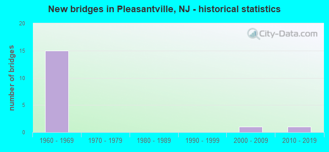
- New bridges - historical statistics
- 151960-1969
- 12000-2009
- 12010-2019

- Reconstructed bridges - Historical Statistics
- 11970-1979
- 21980-1989


- Bridge Condition - Deck
- 11.1%Very good
- 55.6%Good
- 33.3%Satisfactory

- Bridge Condition - Superstructure
- 11.1%Very good
- 11.1%Good
- 66.7%Satisfactory
- 11.1%Fair

- Bridge Condition - Substructure
- 44.4%Good
- 22.2%Satisfactory
- 33.3%Fair
Find on map >> Show street view
Structure Number: 1A0008, Location: 0.53 mi West Rt 30 (Lat: 39.399381, Lng: -74.500489), Route carried "on" structure: County highway 646, Year Built: 2009, Status: Open, Structure Length: 2.10m (6.89ft), Average Daily Traffic: 20,468 (year 2021), Truck Traffic: 4%, Average Future Daily Traffic: 24,562 (year 2041), Design Load: HL 93, Features Intersected: 2 WATER MAINS
Minimum Vertical Clearance: 30+ m (98+ ft), Kilometerpoint: 11.507, Lanes on structure: 2, Owner: County Highway Agency, Approaching Roadway Width: 12.2m (40.0ft), Skew: 5 degrees, Material/Design: Prestressed concrete, Design/Construction: Box Beam or Girders - Multiple, Number Of Spans In Main Unit: 1, Length of Maximum Span: 18.9m (62.0ft), Curb-To-Curb Width: 12.2m (40.0ft), Out-to-Out Width: 30.5m (100.1ft)
Condition: Deck: Satisfactory, Superstructure: Good, Substructure: Good, Operating Rating: 96.9 metric tons, Method Used To Determine Operating Rating: Load and Resistance Factor Rating (LRFR) rating reported by rating factor(RF) method using HL-93 loadings, Inventory Rating: 82.6 metric tons, Method Used To Determine Inventory Rating: Load and Resistance Factor Rating (LRFR) rating reported by rating factor(RF) method using HL-93 loadings, Structural Evaluation: Better than present minimum criteria, Deck Geometry: Somewhat better than minimum adequacy, Approach Roadway Alignment: Equal to present desirable criteria, Designated Inspection Frequency: Every 24 months, Inspection Date: January 2021, Deck Structure Type: Concrete Cast-file-Place, Wearing Surface/Protective System: Wearing Surface: Monolithic Concrete, Deck Protection: Galvanized Reinforcing
Find on map >> Show street view
Structure Number: 350048, Location: 1 MI NE OF RTS9&40&322 JC (Lat: 39.396669, Lng: -74.515000), Route carried "on" structure: City street , Year Built: 1965, Status: Open, Structure Length: 5.21m (17.09ft), Average Daily Traffic: 16,735 (year 2012), Truck Traffic: 3%, Average Future Daily Traffic: 22,935 (year 2032), Design Load: H 20, Features Intersected: ATLANTIC CITY EXPRESSWAY, Facility Carried by Structure: FRANKLIN Boulevard
Minimum Vertical Clearance: 30+ m (98+ ft), Kilometerpoint: 0.000, Lanes on structure: 2, Lanes under structure: 6, Owner: State Toll Authority, Maintenance Responsibility: Private, Approaching Roadway Width: 15.2m (49.9ft), Material/Design: Prestressed concrete, Design/Construction: Stringer/Multi-beam, Number Of Spans In Main Unit: 4, Length of Maximum Span: 17.1m (56.1ft), Curb or Sidewalk Widths: Left: 1.5m (4.9ft), Right: 1.5m (4.9ft), Curb-To-Curb Width: 12.2m (40.0ft), Out-to-Out Width: 15.9m (52.2ft)
Condition: Deck: Satisfactory, Superstructure: Satisfactory, Substructure: Satisfactory, Operating Rating: 89.8 metric tons, Method Used To Determine Operating Rating: Load Factor (LF), Inventory Rating: 65.3 metric tons, Method Used To Determine Inventory Rating: Load Factor (LF), Structural Evaluation: Equal to present minimum criteria, Deck Geometry: Somewhat better than minimum adequacy, Underclear: Somewhat better than minimum adequacy, Approach Roadway Alignment: Better than present minimum criteria, Length Of Structure Improvement: 5.20m (17.06ft), Designated Inspection Frequency: Every 24 months, Inspection Date: March 2020, Deck Structure Type: Concrete Cast-file-Place, Wearing Surface/Protective System: Wearing Surface: Monolithic Concrete
Find on map >> Show street view
Structure Number: 350049, Location: 0.9 MI.FROM INTERCHG.4 (Lat: 39.398331, Lng: -74.520000), Route carried "on" structure: County highway 585, Year Built: 1965, Status: Open, Structure Length: 4.94m (16.21ft), Average Daily Traffic: 16,790 (year 2012), Truck Traffic: 4%, Average Future Daily Traffic: 20,495 (year 2032), Design Load: HS 20, Features Intersected: ATLANTIC CITY EXPRESSWAY, Facility Carried by Structure: SHORE ROAD
Minimum Vertical Clearance: 30+ m (98+ ft), Kilometerpoint: 12.231, Lanes on structure: 2, Lanes under structure: 6, Owner: State Toll Authority, Maintenance Responsibility: Private, Approaching Roadway Width: 9.1m (29.9ft), Material/Design: Prestressed concrete, Design/Construction: Stringer/Multi-beam, Number Of Spans In Main Unit: 4, Length of Maximum Span: 17.4m (57.1ft), Curb or Sidewalk Widths: Left: 1.5m (4.9ft), Right: 1.5m (4.9ft), Curb-To-Curb Width: 9.1m (29.9ft), Out-to-Out Width: 13.0m (42.7ft)
Condition: Deck: Good, Superstructure: Satisfactory, Substructure: Good, Operating Rating: 89.8 metric tons, Method Used To Determine Operating Rating: Load Factor (LF), Inventory Rating: 71.7 metric tons, Method Used To Determine Inventory Rating: Load Factor (LF), Structural Evaluation: Equal to present minimum criteria, Deck Geometry: High priority of corrective action, Underclear: High priority of corrective action, Approach Roadway Alignment: Equal to present desirable criteria, Length Of Structure Improvement: 4.90m (16.08ft), Designated Inspection Frequency: Every 24 months, Inspection Date: April 2020, Bridge Improvement Cost: $2,300,000, Roadway Improvement Cost: $200,000, Total Project Cost: $2,500,000 ( Estimate for 2020), Deck Structure Type: Concrete Cast-file-Place, Wearing Surface/Protective System: Wearing Surface: Monolithic Concrete
Find on map >> Show street view
Structure Number: 350054, Location: AT A.C.EXPWY INTRCHNG. 5 (Lat: 39.401669, Lng: -74.525000), Route carried "on" structure: US 9, Year Built: 1965, Status: Open, Structure Length: 5.09m (16.70ft), Average Daily Traffic: 21,060 (year 2012), Truck Traffic: 4%, Average Future Daily Traffic: 30,820 (year 2032), Design Load: HS 20, Features Intersected: ATLANTIC CITY EXPRESSWAY
Minimum Vertical Clearance: 30+ m (98+ ft), Kilometerpoint: 65.565, Lanes on structure: 2, Lanes under structure: 6, Base Highway Network: Yes, Owner: State Toll Authority, Maintenance Responsibility: Private, Approaching Roadway Width: 14.0m (45.9ft), Material/Design: Prestressed concrete, Design/Construction: Stringer/Multi-beam, Number Of Spans In Main Unit: 4, Length of Maximum Span: 17.4m (57.1ft), Curb or Sidewalk Widths: Left: 1.8m (5.9ft), Right: 1.8m (5.9ft), Curb-To-Curb Width: 14.0m (45.9ft), Out-to-Out Width: 18.3m (60.0ft)
Condition: Deck: Good, Superstructure: Satisfactory, Substructure: Satisfactory, Operating Rating: 89.8 metric tons, Method Used To Determine Operating Rating: Load Factor (LF), Inventory Rating: 38.1 metric tons, Method Used To Determine Inventory Rating: Load Factor (LF), Structural Evaluation: Equal to present minimum criteria, Deck Geometry: Superior to present desirable criteria, Underclear: High priority of corrective action, Approach Roadway Alignment: Better than present minimum criteria, Length Of Structure Improvement: 5.10m (16.73ft), Designated Inspection Frequency: Every 24 months, Inspection Date: April 2020, Deck Structure Type: Concrete Cast-file-Place, Wearing Surface/Protective System: Wearing Surface: Monolithic Concrete
Find on map >> Show street view
Structure Number: 350063, Location: 1 MI SE OF GSP&ACE JCT (Lat: 39.408331, Lng: -74.540000), Route carried "on" structure: City street , Year Built: 1965, Status: Open, Structure Length: 5.70m (18.70ft), Average Daily Traffic: 3,570 (year 2012), Truck Traffic: 3%, Average Future Daily Traffic: 4,305 (year 2032), Design Load: H 20, Features Intersected: ATLANTIC CITY EXPRESSWAY, Facility Carried by Structure: DOUGHTY ROAD
Minimum Vertical Clearance: 30+ m (98+ ft), Kilometerpoint: 0.000, Lanes on structure: 2, Lanes under structure: 6, Owner: State Toll Authority, Maintenance Responsibility: Private, Approaching Roadway Width: 9.8m (32.2ft), Skew: 2 degrees, Material/Design: Prestressed concrete, Design/Construction: Stringer/Multi-beam, Number Of Spans In Main Unit: 4, Length of Maximum Span: 19.5m (64.0ft), Curb or Sidewalk Widths: Left: 1.5m (4.9ft), Right: 1.5m (4.9ft), Curb-To-Curb Width: 10.4m (34.1ft), Out-to-Out Width: 14.0m (45.9ft)
Condition: Deck: Satisfactory, Superstructure: Satisfactory, Substructure: Good, Operating Rating: 89.8 metric tons, Method Used To Determine Operating Rating: Load Factor (LF), Inventory Rating: 40.8 metric tons, Method Used To Determine Inventory Rating: Load Factor (LF), Structural Evaluation: Equal to present minimum criteria, Deck Geometry: Somewhat better than minimum adequacy, Underclear: High priority of corrective action, Approach Roadway Alignment: Equal to present minimum criteria, Length Of Structure Improvement: 5.70m (18.70ft), Designated Inspection Frequency: Every 24 months, Inspection Date: March 2020, Deck Structure Type: Concrete Cast-file-Place, Wearing Surface/Protective System: Wearing Surface: Monolithic Concrete
Find on map >> Show street view
Structure Number: 350065, Location: 0.75 MI SE OF GSP&ACE JCT (Lat: 39.406669, Lng: -74.543331), Route carried "on" structure: County highway 651, Year Built: 1964, Year Reconstructed: 1983, Status: Open, Structure Length: 5.12m (16.80ft), Average Daily Traffic: 16,465 (year 2012), Truck Traffic: 4%, Average Future Daily Traffic: 19,795 (year 2032), Design Load: HS 20+Mod, Features Intersected: ATLANTIC CITY EXPRESSWAY, Facility Carried by Structure: FIRE ROAD
Minimum Vertical Clearance: 30+ m (98+ ft), Kilometerpoint: 15.047, Lanes on structure: 2, Lanes under structure: 6, Owner: State Toll Authority, Maintenance Responsibility: Private, Approaching Roadway Width: 10.4m (34.1ft), Material/Design: Prestressed concrete, Design/Construction: Stringer/Multi-beam, Number Of Spans In Main Unit: 4, Length of Maximum Span: 17.4m (57.1ft), Curb or Sidewalk Widths: Left: 1.2m (3.9ft), Right: 0.5m (1.6ft), Curb-To-Curb Width: 10.4m (34.1ft), Out-to-Out Width: 12.8m (42.0ft)
Condition: Deck: Good, Superstructure: Fair, Substructure: Fair, Operating Rating: 89.8 metric tons, Method Used To Determine Operating Rating: Load Factor (LF), Inventory Rating: 44.5 metric tons, Method Used To Determine Inventory Rating: Load Factor (LF), Structural Evaluation: Somewhat better than minimum adequacy, Deck Geometry: Meets minimum limits, Underclear: High priority of corrective action, Approach Roadway Alignment: Better than present minimum criteria, Length Of Structure Improvement: 4.90m (16.08ft), Designated Inspection Frequency: Every 24 months, Inspection Date: March 2020, Deck Structure Type: Concrete Cast-file-Place, Wearing Surface/Protective System: Wearing Surface: Monolithic Concrete
Find on map >> Show street view
Structure Number: 350072N, Location: 0.75 MI NE OF RT40&322 CI (Lat: 39.413331, Lng: -74.553331), Route carried "on" structure: Other road ACE, Year Built: 1964, Year Reconstructed: 1987, Status: Open, Structure Length: 9.24m (30.31ft), Average Daily Traffic: 39,774 (year 2012), Truck Traffic: 5%, Average Future Daily Traffic: 54,300 (year 2032), Design Load: H 20, Features Intersected: GARDEN STATE PARKWAY, Facility Carried by Structure: A.C. EXPRESSWAY WB
Minimum Vertical Clearance: 30+ m (98+ ft), Kilometerpoint: 11.587, Lanes on structure: 5, Lanes under structure: 7, Base Highway Network: Yes, Toll: On toll road, Owner: State Toll Authority, Maintenance Responsibility: Private, Approaching Roadway Width: 20.4m (66.9ft), Material/Design: Prestressed concrete, Design/Construction: Stringer/Multi-beam, Number Of Spans In Main Unit: 6, Length of Maximum Span: 22.3m (73.2ft), Curb-To-Curb Width: 20.4m (66.9ft), Out-to-Out Width: 21.6m (70.9ft)
Condition: Deck: Very good, Superstructure: Satisfactory, Substructure: Fair, Operating Rating: 81.5 metric tons, Method Used To Determine Operating Rating: Load Factor (LF), Inventory Rating: 33.7 metric tons, Method Used To Determine Inventory Rating: Load Factor (LF), Structural Evaluation: Somewhat better than minimum adequacy, Deck Geometry: Meets minimum limits, Underclear: Equal to present minimum criteria, Approach Roadway Alignment: Better than present minimum criteria, Length Of Structure Improvement: 2.80m (9.19ft), Designated Inspection Frequency: Every 24 months, Inspection Date: March 2020, Bridge Improvement Cost: $3,000,000, Roadway Improvement Cost: $1,475,000, Total Project Cost: $4,475,000 ( Estimate for 2016), Deck Structure Type: Concrete Cast-file-Place, Wearing Surface/Protective System: Wearing Surface: Bituminous
Find on map >> Show street view
Structure Number: 350072S, Location: 0.75 MI NE OF RT40&322 CI (Lat: 39.413331, Lng: -74.553331), Route carried "on" structure: Other road ACE, Year Built: 1964, Year Reconstructed: 1987, Status: Open, Structure Length: 9.24m (30.31ft), Average Daily Traffic: 39,748 (year 2012), Truck Traffic: 5%, Average Future Daily Traffic: 55,403 (year 2032), Design Load: H 20, Features Intersected: GARDEN STATE PARKWAY, Facility Carried by Structure: A.C. EXPRESSWAY EB
Minimum Vertical Clearance: 30+ m (98+ ft), Kilometerpoint: 11.587, Lanes on structure: 4, Lanes under structure: 7, Base Highway Network: Yes, Toll: On toll road, Owner: State Toll Authority, Maintenance Responsibility: Private, Approaching Roadway Width: 20.1m (65.9ft), Material/Design: Prestressed concrete, Design/Construction: Stringer/Multi-beam, Number Of Spans In Main Unit: 6, Length of Maximum Span: 22.3m (73.2ft), Curb-To-Curb Width: 17.7m (58.1ft), Out-to-Out Width: 19.0m (62.3ft)
Condition: Deck: Good, Superstructure: Satisfactory, Substructure: Fair, Operating Rating: 81.5 metric tons, Method Used To Determine Operating Rating: Load Factor (LF), Inventory Rating: 33.7 metric tons, Method Used To Determine Inventory Rating: Load Factor (LF), Structural Evaluation: Somewhat better than minimum adequacy, Deck Geometry: Meets minimum limits, Underclear: Equal to present minimum criteria, Approach Roadway Alignment: Better than present minimum criteria, Designated Inspection Frequency: Every 24 months, Inspection Date: March 2020, Deck Structure Type: Concrete Cast-file-Place, Wearing Surface/Protective System: Wearing Surface: Bituminous
Find on map >> Show street view
Structure Number: 360369A, Location: 0.3 MI S OF AC EXPRESSWAY (Lat: 39.410006, Lng: -74.555858), Route carried "on" structure: Ramp Other road GSP, Year Built: 2015, Status: Open, Structure Length: 4.57m (14.99ft), Average Daily Traffic: 37,500 (year 2021), Truck Traffic: 3%, Average Future Daily Traffic: 45,000 (year 2041), Design Load: HL 93, Features Intersected: Ramp 37SBX, Facility Carried by Structure: Ramp 38SBEA
Minimum Vertical Clearance: 30+ m (98+ ft), Kilometerpoint: 59.385, Lanes on structure: 2, Lanes under structure: 1, Base Highway Network: Yes, Toll: On toll road, Owner: State Toll Authority, Approaching Roadway Width: 9.1m (29.9ft), Skew: 2 degrees, Material/Design: Steel, Design/Construction: Stringer/Multi-beam, Number Of Spans In Main Unit: 1, Length of Maximum Span: 45.1m (148.0ft), Curb-To-Curb Width: 9.1m (29.9ft), Out-to-Out Width: 10.3m (33.8ft)
Condition: Deck: Good, Superstructure: Very good, Substructure: Good, Operating Rating: 52.8 metric tons, Method Used To Determine Operating Rating: Load and Resistance Factor Rating (LRFR) rating reported by rating factor(RF) method using HL-93 loadings, Inventory Rating: 40.8 metric tons, Method Used To Determine Inventory Rating: Load and Resistance Factor Rating (LRFR) rating reported by rating factor(RF) method using HL-93 loadings, Structural Evaluation: Better than present minimum criteria, Deck Geometry: Meets minimum limits, Underclear: Equal to present minimum criteria, Approach Roadway Alignment: Superior to present desirable criteria, Designated Inspection Frequency: Every 24 months, Inspection Date: May 2021, Deck Structure Type: Concrete Cast-file-Place, Wearing Surface/Protective System: Wearing Surface: Monolithic Concrete, Deck Protection: Epoxy Coated Reinforcing
Find on map >> Show street view
Structure Number: 350048, Location: 1 MI NE OF RTS9&40&322 JC (Lat: 39.396669, Lng: -74.515000), Route carried "under" structure: Other road ACE, Year Built: 1965, Structure Length: 0. m, Average Daily Traffic: 78,035 (year 2012), Truck Traffic: 5%, Features Intersected: ATLANTIC CITY EXPRESSWAY, Facility Carried by Structure: FRANKLIN Boulevard
Minimum Vertical Clearance: 4.78m (15.68ft), Kilometerpoint: 7.725, Lanes on structure: 2, Lanes under structure: 6, Material/Design: Prestressed concrete, Design/Construction: Stringer/Multi-beam, Length of Maximum Span: 17.1m (56.1ft)
Find on map >> Show street view
Structure Number: 350049, Location: 0.9 MI.FROM INTERCHG.4 (Lat: 39.398331, Lng: -74.520000), Route carried "under" structure: Other road ACE, Year Built: 1965, Structure Length: 0. m, Average Daily Traffic: 79,535 (year 2012), Truck Traffic: 5%, Features Intersected: ATLANTIC CITY EXPRESSWAY, Facility Carried by Structure: SHORE ROAD
Minimum Vertical Clearance: 4.42m (14.50ft), Kilometerpoint: 7.870, Lanes on structure: 2, Lanes under structure: 6, Material/Design: Prestressed concrete, Design/Construction: Stringer/Multi-beam, Length of Maximum Span: 17.4m (57.1ft)
Find on map >> Show street view
Structure Number: 35005, Location: 0.8 MI NE OF RT9&40 JCT (Lat: 39.398331, Lng: -74.518331), Route carried "under" structure: Other road ACE, Year Built: 1965, Structure Length: 0. m, Average Daily Traffic: 78,175 (year 2012), Truck Traffic: 5%, Features Intersected: ATLANTIC CITY EXPRESSWAY, Facility Carried by Structure: LINDEN AVENUE
Minimum Vertical Clearance: 4.44m (14.57ft), Kilometerpoint: 8.047, Lanes on structure: 2, Lanes under structure: 6, Material/Design: Prestressed concrete, Design/Construction: Stringer/Multi-beam, Length of Maximum Span: 17.1m (56.1ft)
Find on map >> Show street view
Structure Number: 350054, Location: AT A.C.EXPWY INTRCHNG. 5 (Lat: 39.401669, Lng: -74.525000), Route carried "under" structure: Other road ACE, Year Built: 1965, Structure Length: 0. m, Average Daily Traffic: 81,035 (year 2012), Truck Traffic: 5%, Features Intersected: ATLANTIC CITY EXPRESSWAY, Facility Carried by Structure: US ROUTE 9
Minimum Vertical Clearance: 4.42m (14.50ft), Kilometerpoint: 8.690, Lanes on structure: 2, Lanes under structure: 6, Material/Design: Prestressed concrete, Design/Construction: Stringer/Multi-beam, Length of Maximum Span: 17.4m (57.1ft)
Find on map >> Show street view
Structure Number: 350063, Location: 1 MI SE OF GSP&ACE JCT (Lat: 39.408331, Lng: -74.540000), Route carried "under" structure: Other road ACE, Year Built: 1965, Structure Length: 0. m, Average Daily Traffic: 77,955 (year 2012), Truck Traffic: 5%, Features Intersected: ATLANTIC CITY EXPRESSWAY, Facility Carried by Structure: DOUGHTY ROAD
Minimum Vertical Clearance: 4.75m (15.58ft), Kilometerpoint: 10.139, Lanes on structure: 2, Lanes under structure: 6, Material/Design: Prestressed concrete, Design/Construction: Stringer/Multi-beam, Length of Maximum Span: 19.5m (64.0ft)
Find on map >> Show street view
Structure Number: 350065, Location: 0.75 MI SE OF GSP&ACE JCT (Lat: 39.406669, Lng: -74.543331), Route carried "under" structure: Other road ACE, Year Built: 1964, Structure Length: 0. m, Average Daily Traffic: 78,720 (year 2012), Truck Traffic: 5%, Features Intersected: ATLANTIC CITY EXPRESSWAY, Facility Carried by Structure: FIRE ROAD
Minimum Vertical Clearance: 30+ m (98+ ft), Kilometerpoint: 10.429, Lanes on structure: 2, Lanes under structure: 6, Material/Design: Prestressed concrete, Design/Construction: Stringer/Multi-beam, Length of Maximum Span: 17.4m (57.1ft)
Find on map >> Show street view
Structure Number: 350072N, Location: 0.75 MI NE OF RT40&322 CI (Lat: 39.413331, Lng: -74.553331), Route carried "under" structure: Other road GSP, Year Built: 1964, Structure Length: 0. m, Average Daily Traffic: 67,310 (year 2012), Features Intersected: GARDEN STATE PARKWAY, Facility Carried by Structure: A.C. EXPRESSWAY WB
Minimum Vertical Clearance: 4.62m (15.16ft), Kilometerpoint: 59.916, Lanes on structure: 5, Lanes under structure: 7, Toll: On toll road, Material/Design: Prestressed concrete, Design/Construction: Stringer/Multi-beam, Length of Maximum Span: 22.3m (73.2ft)
Find on map >> Show street view
Structure Number: 350072S, Location: 0.75 MI NE OF RT40&322 CI (Lat: 39.413331, Lng: -74.553331), Route carried "under" structure: Other road GSP, Year Built: 1964, Structure Length: 0. m, Average Daily Traffic: 68,660 (year 2012), Features Intersected: GARDEN STATE PARKWAY, Facility Carried by Structure: A.C. EXPRESSWAY EB
Minimum Vertical Clearance: 30+ m (98+ ft), Kilometerpoint: 96.425, Lanes on structure: 4, Lanes under structure: 7, Toll: On toll road, Material/Design: Prestressed concrete, Design/Construction: Stringer/Multi-beam, Length of Maximum Span: 22.3m (73.2ft)