Bridge Statistics for Sauk Rapids, Minnesota (MN)
Condition, Traffic, Stress, Structural Evaluation, Project Costs
- National Bridge Inventory (NBI) Statistics
- 25Number of bridges
- 463ft / 141mTotal length
- $75,000,000Total costs
- 207,836Total average daily traffic
- 9,844Total average daily truck traffic
- National Bridge Inventory (NBI) Registered Bridges for Sauk Rapids
- No street view available for this location
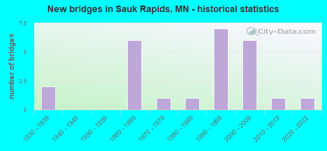
- New bridges - historical statistics
- 21930-1939
- 61960-1969
- 11970-1979
- 11980-1989
- 71990-1999
- 62000-2009
- 12010-2019
- 12020-2022


- Bridge Condition - Substructure
- 85.7%Good
- 14.3%Satisfactory

- Bridge Condition - Channel
- 10.0%Very good
- 60.0%Good
- 30.0%Satisfactory

- Bridge Condition - Culverts
- 12.5%Very good
- 50.0%Good
- 37.5%Satisfactory
Find on map >> Show street view
Structure Number: 5004, Location: 1.2 MI N OF JCT TH 23 (Lat: 45.581906, Lng: -94.146553), Route carried "on" structure: City street 107, Year Built: 1968, Status: Open, Structure Length: 9.15m (30.02ft), Average Daily Traffic: 4,100 (year 2015), Average Future Daily Traffic: 4,100 (year 2039), Design Load: HS 20, Features Intersected: US 10
Minimum Vertical Clearance: 30+ m (98+ ft), Kilometerpoint: 0.000, Lanes on structure: 2, Lanes under structure: 4, Owner: State Highway Agency, Approaching Roadway Width: 8.2m (26.9ft), Skew: 1 degrees, Material/Design: Steel continuous, Design/Construction: Stringer/Multi-beam, Number Of Spans In Main Unit: 4, Length of Maximum Span: 25.5m (83.7ft), Curb or Sidewalk Widths: Left: 1.5m (4.9ft), Right: 0.0m, Curb-To-Curb Width: 11.0m (36.1ft), Out-to-Out Width: 13.5m (44.3ft)
Condition: Deck: Good, Superstructure: Good, Substructure: Good, Operating Rating: 57.1 metric tons, Method Used To Determine Operating Rating: Load Factor (LF), Inventory Rating: 34.3 metric tons, Method Used To Determine Inventory Rating: Load Factor (LF), Structural Evaluation: Better than present minimum criteria, Deck Geometry: Somewhat better than minimum adequacy, Underclear: Better than present minimum criteria, Approach Roadway Alignment: Equal to present desirable criteria, Designated Inspection Frequency: Every 24 months, Inspection Date: September 2021, Deck Structure Type: Concrete Cast-file-Place, Wearing Surface/Protective System: Wearing Surface: Low Slump Concrete
Find on map >> Show street view
Structure Number: 5005, Location: 0.9 MI N OF JCT TH 23 (Lat: 45.577739, Lng: -94.147469), Route carried "on" structure: City street 109, Year Built: 1969, Status: Open, Structure Length: 8.95m (29.36ft), Average Daily Traffic: 6,200 (year 2015), Average Future Daily Traffic: 6,200 (year 2039), Design Load: HS 20, Features Intersected: US 10
Minimum Vertical Clearance: 30+ m (98+ ft), Kilometerpoint: 0.000, Lanes on structure: 2, Lanes under structure: 4, Owner: State Highway Agency, Approaching Roadway Width: 13.4m (44.0ft), Skew: 2 degrees, Material/Design: Prestressed concrete, Design/Construction: Stringer/Multi-beam, Number Of Spans In Main Unit: 4, Length of Maximum Span: 26.4m (86.6ft), Curb-To-Curb Width: 14.2m (46.6ft), Out-to-Out Width: 15.5m (50.9ft)
Condition: Deck: Good, Superstructure: Good, Substructure: Satisfactory, Operating Rating: 58.3 metric tons, Method Used To Determine Operating Rating: Load Factor (LF), Inventory Rating: 24.4 metric tons, Method Used To Determine Inventory Rating: Load Factor (LF), Structural Evaluation: Equal to present minimum criteria, Deck Geometry: Superior to present desirable criteria, Underclear: Equal to present desirable criteria, Approach Roadway Alignment: Equal to present desirable criteria, Designated Inspection Frequency: Every 24 months, Inspection Date: September 2021, Deck Structure Type: Concrete Cast-file-Place, Wearing Surface/Protective System: Wearing Surface: Low Slump Concrete
Find on map >> Show street view
Structure Number: 5006, Location: 2.4 MI N OF JCT TH 23 (Lat: 45.598483, Lng: -94.148781), Route carried "on" structure: County highway 3, Year Built: 1969, Status: Open, Structure Length: 8.89m (29.17ft), Average Daily Traffic: 8,900 (year 2015), Average Future Daily Traffic: 8,900 (year 2039), Design Load: HS 20, Features Intersected: US 10
Minimum Vertical Clearance: 30+ m (98+ ft), Kilometerpoint: 0.000, Lanes on structure: 2, Lanes under structure: 4, Owner: State Highway Agency, Approaching Roadway Width: 12.2m (40.0ft), Skew: 2 degrees, Material/Design: Prestressed concrete, Design/Construction: Stringer/Multi-beam, Number Of Spans In Main Unit: 4, Length of Maximum Span: 26.3m (86.3ft), Curb or Sidewalk Widths: Left: 3.0m (9.8ft), Right: 0.0m, Curb-To-Curb Width: 12.2m (40.0ft), Out-to-Out Width: 14.8m (48.6ft)
Condition: Deck: Good, Superstructure: Good, Substructure: Good, Operating Rating: 58.4 metric tons, Method Used To Determine Operating Rating: Load Factor (LF), Inventory Rating: 21.4 metric tons, Method Used To Determine Inventory Rating: Load Factor (LF), Structural Evaluation: Somewhat better than minimum adequacy, Deck Geometry: Somewhat better than minimum adequacy, Underclear: Better than present minimum criteria, Approach Roadway Alignment: Equal to present desirable criteria, Designated Inspection Frequency: Every 24 months, Inspection Date: September 2021, Deck Structure Type: Concrete Cast-file-Place, Wearing Surface/Protective System: Wearing Surface: Low Slump Concrete
Find on map >> Show street view
Structure Number: 5007, Location: 4.4 MI N OF JCT TH 23 (Lat: 45.616072, Lng: -94.168244), Route carried "on" structure: County highway 29, Year Built: 1995, Status: Open, Structure Length: 6.86m (22.51ft), Average Daily Traffic: 4,600 (year 2015), Average Future Daily Traffic: 4,600 (year 2039), Design Load: HS 25 or greater, Features Intersected: US 10
Minimum Vertical Clearance: 30+ m (98+ ft), Kilometerpoint: 0.000, Lanes on structure: 2, Lanes under structure: 6, Owner: State Highway Agency, Approaching Roadway Width: 20.4m (66.9ft), Skew: 20 degrees, Material/Design: Prestressed concrete, Design/Construction: Stringer/Multi-beam, Number Of Spans In Main Unit: 2, Length of Maximum Span: 33.6m (110.2ft), Curb-To-Curb Width: 15.9m (52.2ft), Out-to-Out Width: 21.7m (71.2ft)
Condition: Deck: Good, Superstructure: Good, Substructure: Good, Operating Rating: 76.7 metric tons, Method Used To Determine Operating Rating: Load Factor (LF), Inventory Rating: 46.1 metric tons, Method Used To Determine Inventory Rating: Load Factor (LF), Structural Evaluation: Better than present minimum criteria, Deck Geometry: Superior to present desirable criteria, Underclear: Somewhat better than minimum adequacy, Approach Roadway Alignment: Equal to present desirable criteria, Designated Inspection Frequency: Every 24 months, Inspection Date: October 2021, Deck Structure Type: Concrete Cast-file-Place, Wearing Surface/Protective System: Wearing Surface: Monolithic Concrete, Deck Protection: Epoxy Coated Reinforcing
Find on map >> Show street view
Structure Number: 5011, Location: 3.3 MI N OF JCT TH 23 (Lat: 45.599689, Lng: -94.187653), Route carried "on" structure: State highway 15, Year Built: 1993, Status: Open, Structure Length: 52.14m (171.06ft), Average Daily Traffic: 26,000 (year 2019), Truck Traffic: 5%, Average Future Daily Traffic: 24,800 (year 2039), Design Load: HS 25 or greater, Features Intersected: BENTON DR, MISS RVR, RR
Minimum Vertical Clearance: 30+ m (98+ ft), Kilometerpoint: 0.000, Lanes on structure: 4, Lanes under structure: 4, Base Highway Network: Yes, Owner: State Highway Agency, Approaching Roadway Width: 25.0m (82.0ft), Skew: 31 degrees, Material/Design: Prestressed concrete, Design/Construction: Stringer/Multi-beam, Number Of Spans In Main Unit: 13, Length of Maximum Span: 42.7m (140.1ft), Curb-To-Curb Width: 24.4m (80.1ft), Out-to-Out Width: 26.0m (85.3ft)
Condition: Deck: Good, Superstructure: Good, Substructure: Good, Channel: Satisfactory, Operating Rating: 72.2 metric tons, Method Used To Determine Operating Rating: Load Factor (LF), Inventory Rating: 39.5 metric tons, Method Used To Determine Inventory Rating: Load Factor (LF), Structural Evaluation: Better than present minimum criteria, Deck Geometry: Superior to present desirable criteria, Underclear: Better than present minimum criteria, Waterway Adequacy: Equal to present desirable criteria, Approach Roadway Alignment: Equal to present desirable criteria, Designated Inspection Frequency: Every 24 months, Underwater Inspection Frequency: Every 60 months, Inspection Date: September 2020, Underwater Inspection Date: August 2021, Deck Structure Type: Concrete Cast-file-Place, Wearing Surface/Protective System: Wearing Surface: Low Slump Concrete, Deck Protection: Epoxy Coated Reinforcing
Find on map >> Show street view
Structure Number: 5016, Location: 2.5 mi N of jct TH 15; 10 (Lat: 45.654544, Lng: -94.177597), Route carried "on" structure: County highway 33, Year Built: 2002, Status: Open, Structure Length: 7.09m (23.26ft), Average Daily Traffic: 1,850 (year 2019), Truck Traffic: 4%, Average Future Daily Traffic: 1,500 (year 2039), Design Load: HS 25 or greater, Features Intersected: US 10
Minimum Vertical Clearance: 30+ m (98+ ft), Kilometerpoint: 0.000, Lanes on structure: 3, Lanes under structure: 6, Owner: State Highway Agency, Approaching Roadway Width: 17.7m (58.1ft), Skew: 20 degrees, Material/Design: Prestressed concrete, Design/Construction: Stringer/Multi-beam, Number Of Spans In Main Unit: 2, Length of Maximum Span: 38.3m (125.7ft), Curb or Sidewalk Widths: Left: 0.0m, Right: 2.7m (8.9ft), Curb-To-Curb Width: 17.7m (58.1ft), Out-to-Out Width: 23.8m (78.1ft)
Condition: Deck: Good, Superstructure: Good, Substructure: Good, Operating Rating: 69.7 metric tons, Method Used To Determine Operating Rating: Load Factor (LF), Inventory Rating: 47.7 metric tons, Method Used To Determine Inventory Rating: Load Factor (LF), Structural Evaluation: Better than present minimum criteria, Deck Geometry: Superior to present desirable criteria, Underclear: Equal to present minimum criteria, Approach Roadway Alignment: Equal to present desirable criteria, Designated Inspection Frequency: Every 24 months, Inspection Date: September 2021, Deck Structure Type: Concrete Cast-file-Place, Wearing Surface/Protective System: Wearing Surface: Low Slump Concrete, Deck Protection: Epoxy Coated Reinforcing
Find on map >> Show street view
Structure Number: 5534, Location: AT CO LINE (Lat: 45.588847, Lng: -94.170044), Route carried "on" structure: City street 115, Year Built: 2006, Status: Open, Structure Length: 39.57m (129.82ft), Average Daily Traffic: 20,400 (year 2015), Average Future Daily Traffic: 20,400 (year 2039), Design Load: HS 25 or greater, Features Intersected: MISS R, BNSF RR, STRS
Minimum Vertical Clearance: 30+ m (98+ ft), Kilometerpoint: 0.000, Lanes on structure: 4, Lanes under structure: 4, Owner: City or Municipal Highway Agency, Approaching Roadway Width: 17.1m (56.1ft), Skew: 23 degrees, Material/Design: Steel continuous, Design/Construction: Stringer/Multi-beam, Number Of Spans In Main Unit: 4, Number Of Approach Spans: 5, Length of Maximum Span: 89.9m (294.9ft), Curb or Sidewalk Widths: Left: 3.0m (9.8ft), Right: 3.0m (9.8ft), Curb-To-Curb Width: 17.1m (56.1ft), Out-to-Out Width: 25.8m (84.6ft)
Condition: Deck: Good, Superstructure: Good, Substructure: Good, Channel: Good, Operating Rating: 44.7 metric tons, Method Used To Determine Operating Rating: Load and Resistance Factor Rating (LRFR) rating reported by rating factor(RF) method using HL-93 loadings, Inventory Rating: 34.3 metric tons, Method Used To Determine Inventory Rating: Load and Resistance Factor Rating (LRFR) rating reported by rating factor(RF) method using HL-93 loadings, Structural Evaluation: Better than present minimum criteria, Deck Geometry: Somewhat better than minimum adequacy, Underclear: Better than present minimum criteria, Waterway Adequacy: Superior to present desirable criteria, Approach Roadway Alignment: Equal to present desirable criteria, Designated Inspection Frequency: Every 24 months, Inspection Date: October 2020, Deck Structure Type: Concrete Cast-file-Place, Wearing Surface/Protective System: Wearing Surface: Low Slump Concrete, Deck Protection: Epoxy Coated Reinforcing
Find on map >> Show street view
Structure Number: 5J14, Location: 0.4 MI N OF JCT CSAH 3 (Lat: 45.616264, Lng: -94.111992), Route carried "on" structure: County highway 22, Year Built: 2011, Status: Open, Structure Length: 1.28m (4.20ft), Average Daily Traffic: 49 (year 2010), Average Future Daily Traffic: 49 (year 2030), Design Load: HS 25 or greater, Features Intersected: MAYHEW CREEK
Minimum Vertical Clearance: 30+ m (98+ ft), Kilometerpoint: 0.000, Lanes on structure: 2, Owner: Town or Township Highway Agency, Approaching Roadway Width: 8.5m (27.9ft), Skew: 4 degrees, Material/Design: Concrete, Design/Construction: Culvert, Number Of Spans In Main Unit: 2, Length of Maximum Span: 6.0m (19.7ft)
Condition: Channel: Good, Culverts: Good, Operating Rating: 58.8 metric tons, Method Used To Determine Operating Rating: Assigned ratings based on Load and Resistance Factor Design (LRFD) reported in metric tons, Inventory Rating: 39.2 metric tons, Method Used To Determine Inventory Rating: Assigned ratings based on Load and Resistance Factor Design (LRFD) reported in metric tons, Structural Evaluation: Better than present minimum criteria, Waterway Adequacy: Equal to present desirable criteria, Approach Roadway Alignment: Equal to present desirable criteria, Designated Inspection Frequency: Every 48 months, Inspection Date: October 2019
Find on map >> Show street view
Structure Number: 5J17, Location: 0.75 MI S OF JCT CSAH 3 (Lat: 45.606711, Lng: -94.091153), Route carried "on" structure: County highway 80, Year Built: 2021, Status: Open, Structure Length: 1.59m (5.22ft), Average Daily Traffic: 660 (year 2021), Average Future Daily Traffic: 1,100 (year 2041), Design Load: HL 93, Features Intersected: MAYHEW CREEK
Minimum Vertical Clearance: 30+ m (98+ ft), Kilometerpoint: 0.000, Lanes on structure: 2, Owner: County Highway Agency, Approaching Roadway Width: 11.0m (36.1ft), Skew: 2 degrees, Material/Design: Concrete, Design/Construction: Culvert, Number Of Spans In Main Unit: 3, Length of Maximum Span: 5.4m (17.7ft)
Condition: Channel: Very good, Culverts: Very good, Operating Rating: 42.1 metric tons, Method Used To Determine Operating Rating: Assigned ratings based on Load and Resistance Factor Design (LRFD) reported by rating factor (RF) using HL93 loadings, Inventory Rating: 32.4 metric tons, Method Used To Determine Inventory Rating: Assigned ratings based on Load and Resistance Factor Design (LRFD) reported by rating factor (RF) using HL93 loadings, Structural Evaluation: Equal to present desirable criteria, Waterway Adequacy: Equal to present desirable criteria, Approach Roadway Alignment: Meets minimum limits, Designated Inspection Frequency: Every 24 months, Inspection Date: December 2021
Find on map >> Show street view
Structure Number: 9343, Location: 0.8 MI E OF JCT CSAH 1 (Lat: 45.661956, Lng: -94.117614), Route carried "on" structure: County highway 4, Year Built: 1979, Status: Open, Structure Length: 1.25m (4.10ft), Average Daily Traffic: 1,400 (year 2015), Average Future Daily Traffic: 1,400 (year 2039), Design Load: HS 20, Features Intersected: MAYHEW CREEK
Minimum Vertical Clearance: 30+ m (98+ ft), Kilometerpoint: 0.000, Lanes on structure: 2, Owner: County Highway Agency, Approaching Roadway Width: 12.2m (40.0ft), Skew: 1 degrees, Material/Design: Concrete, Design/Construction: Culvert, Number Of Spans In Main Unit: 3, Length of Maximum Span: 3.0m (9.8ft)
Condition: Channel: Good, Culverts: Satisfactory, Operating Rating: 39.2 metric tons, Method Used To Determine Operating Rating: Assigned ratings based on Allowable Stress Design (ASD) reported in metric tons, Inventory Rating: 29.4 metric tons, Method Used To Determine Inventory Rating: Assigned ratings based on Allowable Stress Design (ASD) reported in metric tons, Structural Evaluation: Equal to present minimum criteria, Waterway Adequacy: Superior to present desirable criteria, Approach Roadway Alignment: Equal to present desirable criteria, Designated Inspection Frequency: Every 24 months, Inspection Date: November 2021
Find on map >> Show street view
Structure Number: 96217, Location: 0.2 MI S OF JCT CSAH 3 (Lat: 45.614925, Lng: -94.091242), Route carried "on" structure: County highway 80, Year Built: 1986, Status: Open, Structure Length: 1.07m (3.51ft), Average Daily Traffic: 455 (year 2011), Average Future Daily Traffic: 455 (year 2039), Design Load: HS 20, Features Intersected: MAYHEW CREEK (CD # 11)
Minimum Vertical Clearance: 30+ m (98+ ft), Kilometerpoint: 0.000, Lanes on structure: 2, Owner: County Highway Agency, Approaching Roadway Width: 7.3m (24.0ft), Material/Design: Concrete, Design/Construction: Culvert, Number Of Spans In Main Unit: 2, Length of Maximum Span: 4.3m (14.1ft)
Condition: Channel: Satisfactory, Culverts: Good, Operating Rating: 39.2 metric tons, Method Used To Determine Operating Rating: Assigned ratings based on Allowable Stress Design (ASD) reported in metric tons, Inventory Rating: 29.4 metric tons, Method Used To Determine Inventory Rating: Assigned ratings based on Allowable Stress Design (ASD) reported in metric tons, Structural Evaluation: Better than present minimum criteria, Waterway Adequacy: Equal to present desirable criteria, Approach Roadway Alignment: Equal to present desirable criteria, Designated Inspection Frequency: Every 24 months, Inspection Date: October 2021
Find on map >> Show street view
Structure Number: 97474, Location: 0.4 MI E OF JCT CSAH 1 (Lat: 45.632131, Lng: -94.124397), Route carried "on" structure: County highway 15, Year Built: 1995, Status: Open, Structure Length: 0.79m (2.59ft), Average Daily Traffic: 620 (year 2015), Average Future Daily Traffic: 620 (year 2039), Design Load: HS 20, Features Intersected: MAYHEW CREEK
Minimum Vertical Clearance: 30+ m (98+ ft), Kilometerpoint: 0.000, Lanes on structure: 2, Owner: County Highway Agency, Approaching Roadway Width: 11.0m (36.1ft), Material/Design: Concrete, Design/Construction: Culvert, Number Of Spans In Main Unit: 2, Length of Maximum Span: 3.1m (10.2ft)
Condition: Channel: Good, Culverts: Good, Operating Rating: 53.9 metric tons, Method Used To Determine Operating Rating: Assigned ratings based on Allowable Stress Design (ASD) reported in metric tons, Inventory Rating: 35.9 metric tons, Method Used To Determine Inventory Rating: Assigned ratings based on Allowable Stress Design (ASD) reported in metric tons, Structural Evaluation: Better than present minimum criteria, Waterway Adequacy: Equal to present desirable criteria, Approach Roadway Alignment: Equal to present desirable criteria, Designated Inspection Frequency: Every 48 months, Inspection Date: October 2021
Find on map >> Show street view
Structure Number: 97475, Location: 0.5 MI E OF JCT CSAH 1 (Lat: 45.647283, Lng: -94.130878), Route carried "on" structure: County highway 22, Year Built: 1995, Status: Open, Structure Length: 0.76m (2.49ft), Average Daily Traffic: 15 (year 1994), Average Future Daily Traffic: 15 (year 2029), Design Load: HS 20, Features Intersected: MAYHEW CREEK
Minimum Vertical Clearance: 30+ m (98+ ft), Kilometerpoint: 0.000, Lanes on structure: 2, Owner: Town or Township Highway Agency, Approaching Roadway Width: 8.5m (27.9ft), Material/Design: Concrete, Design/Construction: Culvert, Number Of Spans In Main Unit: 2, Length of Maximum Span: 2.9m (9.5ft)
Condition: Channel: Good, Culverts: Satisfactory, Operating Rating: 53.9 metric tons, Method Used To Determine Operating Rating: Assigned ratings based on Allowable Stress Design (ASD) reported in metric tons, Inventory Rating: 35.9 metric tons, Method Used To Determine Inventory Rating: Assigned ratings based on Allowable Stress Design (ASD) reported in metric tons, Structural Evaluation: Equal to present minimum criteria, Waterway Adequacy: Equal to present desirable criteria, Approach Roadway Alignment: Equal to present desirable criteria, Designated Inspection Frequency: Every 48 months, Inspection Date: November 2019
Find on map >> Show street view
Structure Number: L0002, Location: 0.2 MI W OF JCT CR 58 (Lat: 45.612178, Lng: -94.105867), Route carried "on" structure: County highway 3, Year Built: 1936, Year Reconstructed: 1987, Status: Open, Structure Length: 0.67m (2.20ft), Average Daily Traffic: 2,250 (year 2015), Average Future Daily Traffic: 2,250 (year 2029), Features Intersected: MAYHEW CREEK
Minimum Vertical Clearance: 30+ m (98+ ft), Kilometerpoint: 0.000, Lanes on structure: 2, Owner: County Highway Agency, Approaching Roadway Width: 12.2m (40.0ft), Material/Design: Concrete, Design/Construction: Culvert, Number Of Spans In Main Unit: 2, Length of Maximum Span: 3.0m (9.8ft)
Condition: Channel: Satisfactory, Culverts: Good, Operating Rating: 53.9 metric tons, Method Used To Determine Operating Rating: Assigned ratings based on Allowable Stress Design (ASD) reported in metric tons, Inventory Rating: 35.9 metric tons, Method Used To Determine Inventory Rating: Assigned ratings based on Allowable Stress Design (ASD) reported in metric tons, Structural Evaluation: Better than present minimum criteria, Waterway Adequacy: Equal to present desirable criteria, Approach Roadway Alignment: Equal to present desirable criteria, Designated Inspection Frequency: Every 24 months, Inspection Date: October 2021
Find on map >> Show street view
Structure Number: L0041, Location: 0.2 MI N OF JCT CSAH 8 (Lat: 45.591689, Lng: -94.090850), Route carried "on" structure: County highway 80, Year Built: 1938, Status: Open, Structure Length: 1.00m (3.28ft), Average Daily Traffic: 455 (year 2011), Average Future Daily Traffic: 455 (year 2039), Features Intersected: MAYHEW CREEK
Minimum Vertical Clearance: 30+ m (98+ ft), Kilometerpoint: 0.000, Lanes on structure: 2, Owner: County Highway Agency, Approaching Roadway Width: 7.9m (25.9ft), Material/Design: Concrete, Design/Construction: Culvert, Number Of Spans In Main Unit: 3, Length of Maximum Span: 3.0m (9.8ft)
Condition: Channel: Good, Culverts: Satisfactory, Operating Rating: 39.2 metric tons, Method Used To Determine Operating Rating: Assigned ratings based on Allowable Stress Design (ASD) reported in metric tons, Inventory Rating: 29.4 metric tons, Method Used To Determine Inventory Rating: Assigned ratings based on Allowable Stress Design (ASD) reported in metric tons, Structural Evaluation: Equal to present minimum criteria, Waterway Adequacy: Better than present minimum criteria, Approach Roadway Alignment: Equal to present desirable criteria, Length Of Structure Improvement: 0.49m (1.61ft), Designated Inspection Frequency: Every 24 months, Inspection Date: October 2021, Bridge Improvement Cost: $141,000,000, Roadway Improvement Cost: $8,000,000, Total Project Cost: $75,000,000
Find on map >> Show street view
Structure Number: 5004, Location: 1.2 MI N OF JCT TH 23 (Lat: 45.581906, Lng: -94.146553), Route carried "under" structure: US 10, Year Built: 1968, Structure Length: 0. m, Average Daily Traffic: 22,500 (year 2019), Truck Traffic: 7%, Features Intersected: US 10
Minimum Vertical Clearance: 6.52m (21.39ft), Kilometerpoint: 0.000, Lanes on structure: 2, Lanes under structure: 4, Material/Design: Steel continuous, Design/Construction: Stringer/Multi-beam, Length of Maximum Span: 25.5m (83.7ft)
Find on map >> Show street view
Structure Number: 5005, Location: 0.9 MI N OF JCT TH 23 (Lat: 45.577739, Lng: -94.147469), Route carried "under" structure: US 10, Year Built: 1969, Structure Length: 0. m, Average Daily Traffic: 22,500 (year 2019), Truck Traffic: 7%, Features Intersected: US 10
Minimum Vertical Clearance: 5.43m (17.81ft), Kilometerpoint: 0.000, Lanes on structure: 2, Lanes under structure: 4, Material/Design: Prestressed concrete, Design/Construction: Stringer/Multi-beam, Length of Maximum Span: 26.4m (86.6ft)
Find on map >> Show street view
Structure Number: 5006, Location: 2.4 MI N OF JCT TH 23 (Lat: 45.598483, Lng: -94.148781), Route carried "under" structure: US 10, Year Built: 1969, Structure Length: 0. m, Average Daily Traffic: 22,500 (year 2019), Truck Traffic: 7%, Features Intersected: US 10, Facility Carried by Structure: CSAH 3
Minimum Vertical Clearance: 5.33m (17.49ft), Kilometerpoint: 0.000, Lanes on structure: 2, Lanes under structure: 4, Material/Design: Prestressed concrete, Design/Construction: Stringer/Multi-beam, Length of Maximum Span: 26.3m (86.3ft)
Find on map >> Show street view
Structure Number: 5007, Location: 4.4 MI N OF JCT TH 23 (Lat: 45.616072, Lng: -94.168244), Route carried "under" structure: US 10, Year Built: 1995, Structure Length: 0. m, Average Daily Traffic: 22,500 (year 2019), Truck Traffic: 7%, Features Intersected: US 10, Facility Carried by Structure: CSAH 29
Minimum Vertical Clearance: 5.64m (18.50ft), Kilometerpoint: 0.000, Lanes on structure: 2, Lanes under structure: 6, Material/Design: Prestressed concrete, Design/Construction: Stringer/Multi-beam, Length of Maximum Span: 33.6m (110.2ft)
Find on map >> Show street view
Structure Number: 5011, Location: 3.3 MI N OF JCT TH 23 (Lat: 45.599689, Lng: -94.187653), Route carried "under" structure: County highway 33, Year Built: 1993, Structure Length: 0. m, Average Daily Traffic: 8,800 (year 2003), Features Intersected: BENTON DR, MISS RVR, RR, Facility Carried by Structure: MN 15
Minimum Vertical Clearance: 5.00m (16.40ft), Kilometerpoint: 0.000, Lanes on structure: 4, Lanes under structure: 3, Material/Design: Prestressed concrete, Design/Construction: Stringer/Multi-beam, Length of Maximum Span: 42.7m (140.1ft)
Find on map >> Show street view
Structure Number: 5011, Location: 3.3 MI N OF JCT TH 23 (Lat: 45.599689, Lng: -94.187653), Route carried "under" structure: City street 66, Year Built: 1993, Structure Length: 0. m, Average Daily Traffic: 1 (year 2019), Features Intersected: BENTON DR, MISS RVR, RR, Facility Carried by Structure: MN 15
Minimum Vertical Clearance: 7.01m (23.00ft), Kilometerpoint: 0.000, Lanes under structure: 1, Material/Design: Prestressed concrete, Design/Construction: Stringer/Multi-beam, Length of Maximum Span: 42.7m (140.1ft)
Find on map >> Show street view
Structure Number: 5016, Location: 2.5 mi N of jct TH 15; 10 (Lat: 45.654544, Lng: -94.177597), Route carried "under" structure: US 10, Year Built: 2002, Structure Length: 0. m, Average Daily Traffic: 31,000 (year 2019), Truck Traffic: 7%, Features Intersected: US 10, Facility Carried by Structure: CSAH 33
Minimum Vertical Clearance: 4.91m (16.11ft), Kilometerpoint: 0.000, Lanes on structure: 3, Lanes under structure: 5, Material/Design: Prestressed concrete, Design/Construction: Stringer/Multi-beam, Length of Maximum Span: 38.3m (125.7ft)
Find on map >> Show street view
Structure Number: 5016, Location: 2.5 mi N of jct TH 15; 10 (Lat: 45.654544, Lng: -94.177597), Route carried "under" structure: Ramp US 1477, Year Built: 2002, Structure Length: 0. m, Average Daily Traffic: 1 (year 2019), Features Intersected: US 10, Facility Carried by Structure: CSAH 33
Minimum Vertical Clearance: 4.88m (16.01ft), Kilometerpoint: 0.000, Lanes under structure: 1, Material/Design: Prestressed concrete, Design/Construction: Stringer/Multi-beam, Length of Maximum Span: 38.3m (125.7ft)
Find on map >> Show street view
Structure Number: 5534, Location: AT CO LINE (Lat: 45.588847, Lng: -94.170044), Route carried "under" structure: City street 117, Year Built: 2006, Structure Length: 0. m, Average Daily Traffic: 50 (year 2006), Features Intersected: MISS R, BNSF RR, STRS, Facility Carried by Structure: MSAS 115
Minimum Vertical Clearance: 7.29m (23.92ft), Kilometerpoint: 0.000, Lanes on structure: 4, Lanes under structure: 2, Material/Design: Steel continuous, Design/Construction: Stringer/Multi-beam, Length of Maximum Span: 89.9m (294.9ft)
Find on map >> Show street view
Structure Number: 5534, Location: AT CO LINE (Lat: 45.588847, Lng: -94.170044), Route carried "under" structure: City street 66, Year Built: 2006, Structure Length: 0. m, Average Daily Traffic: 30 (year 2006), Features Intersected: MISS R, BNSF RR, STRS, Facility Carried by Structure: MSAS 115
Minimum Vertical Clearance: 9.11m (29.89ft), Kilometerpoint: 0.000, Lanes on structure: 4, Lanes under structure: 2, Material/Design: Steel continuous, Design/Construction: Stringer/Multi-beam, Length of Maximum Span: 89.9m (294.9ft)