Bridge Statistics for Tuckahoe, Virginia (VA)
Condition, Traffic, Stress, Structural Evaluation, Project Costs
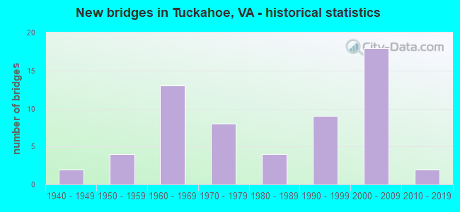
- New bridges - historical statistics
- 21940-1949
- 41950-1959
- 131960-1969
- 81970-1979
- 41980-1989
- 91990-1999
- 182000-2009
- 22010-2019

- Reconstructed bridges - Historical Statistics
- 12000-2009
- 22010-2019


- Bridge Condition - Deck
- 39.3%Good
- 50.0%Satisfactory
- 3.6%Fair
- 7.1%Poor

- Bridge Condition - Superstructure
- 10.7%Very good
- 46.4%Good
- 28.6%Satisfactory
- 14.3%Fair

- Bridge Condition - Substructure
- 28.6%Good
- 46.4%Satisfactory
- 21.4%Fair
- 3.6%Poor

- Bridge Condition - Channel
- 14.7%Good
- 47.1%Satisfactory
- 35.3%Fair
- 2.9%Poor

- Bridge Condition - Culverts
- 5.9%Good
- 76.5%Satisfactory
- 17.6%Fair
Find on map >> Show street view
Structure Number: 8666, Location: 1.69Fr 649&.03 Henrico CL (Lat: 37.587556, Lng: -77.618564), Route carried "on" structure: County highway 650, Year Built: 1950, Year Reconstructed: 2015, Status: Open, Structure Length: 3.57m (11.71ft), Average Daily Traffic: 3,850 (year 2020), Truck Traffic: 1%, Average Future Daily Traffic: 5,390 (year 2040), Design Load: HS 20+Mod, Features Intersected: TUCKAHOE CREEK, Facility Carried by Structure: RIVER ROAD
Minimum Vertical Clearance: 30+ m (98+ ft), Kilometerpoint: 6.983, Lanes on structure: 2, Owner: State Highway Agency, Approaching Roadway Width: 8.5m (27.9ft), Material/Design: Steel continuous, Design/Construction: Stringer/Multi-beam, Number Of Spans In Main Unit: 3, Length of Maximum Span: 11.4m (37.4ft), Curb-To-Curb Width: 8.5m (27.9ft), Out-to-Out Width: 9.3m (30.5ft)
Condition: Deck: Good, Superstructure: Good, Substructure: Good, Channel: Fair, Operating Rating: 86.2 metric tons, Method Used To Determine Operating Rating: Load and Resistance Factor (LRFR), Inventory Rating: 66.2 metric tons, Method Used To Determine Inventory Rating: Load and Resistance Factor (LRFR), Structural Evaluation: Better than present minimum criteria, Deck Geometry: Meets minimum limits, Waterway Adequacy: Equal to present desirable criteria, Approach Roadway Alignment: Equal to present desirable criteria, Length Of Structure Improvement: 3.51m (11.52ft), Designated Inspection Frequency: Every 24 months, Underwater Inspection Frequency: Every 60 months, Inspection Date: October 2021, Underwater Inspection Date: January 2018, Bridge Improvement Cost: $1,640,000, Roadway Improvement Cost: $80,000, Total Project Cost: $2,236,000, Deck Structure Type: Concrete Cast-file-Place
Find on map >> Show street view
Structure Number: 9612, Location: 0.51HUNGY SPR0.50FOREST A (Lat: 37.612083, Lng: -77.537853), Route carried "on" structure: County highway 7667, Year Built: 1967, Status: Open, Structure Length: 10.73m (35.20ft), Average Daily Traffic: 9,557 (year 2020), Truck Traffic: 2%, Average Future Daily Traffic: 10,513 (year 2040), Design Load: HS 20+Mod, Features Intersected: ROUTE 0064, Facility Carried by Structure: SKIPWITH ROAD
Minimum Vertical Clearance: 30+ m (98+ ft), Kilometerpoint: 1.657, Lanes on structure: 2, Lanes under structure: 6, Owner: State Highway Agency, Approaching Roadway Width: 11.6m (38.1ft), Skew: 4 degrees, Material/Design: Steel, Design/Construction: Stringer/Multi-beam, Number Of Spans In Main Unit: 5, Length of Maximum Span: 25.7m (84.3ft), Curb or Sidewalk Widths: Left: 1.5m (4.9ft), Right: 1.5m (4.9ft), Curb-To-Curb Width: 8.5m (27.9ft), Out-to-Out Width: 12.2m (40.0ft)
Condition: Deck: Poor, Superstructure: Fair, Substructure: Fair, Operating Rating: 68.9 metric tons, Method Used To Determine Operating Rating: Load and Resistance Factor (LRFR), Inventory Rating: 52.6 metric tons, Method Used To Determine Inventory Rating: Load and Resistance Factor (LRFR), Structural Evaluation: Somewhat better than minimum adequacy, Deck Geometry: Meets minimum limits, Underclear: Somewhat better than minimum adequacy, Approach Roadway Alignment: Equal to present desirable criteria, Length Of Structure Improvement: 10.73m (35.20ft), Designated Inspection Frequency: Every 12 months, Inspection Date: August 2021, Bridge Improvement Cost: $180,000, Roadway Improvement Cost: $1,000, Total Project Cost: $217,000, Deck Structure Type: Concrete Cast-file-Place
Find on map >> Show street view
Structure Number: 9614, Location: 1.04THR CH RD0.89SKIPWITH (Lat: 37.623869, Lng: -77.554306), Route carried "on" structure: County highway 7518, Year Built: 1967, Year Reconstructed: 2000, Status: Open, Structure Length: 9.16m (30.05ft), Average Daily Traffic: 18,224 (year 2020), Truck Traffic: 2%, Average Future Daily Traffic: 20,656 (year 2040), Design Load: HS 20+Mod, Features Intersected: ROUTE 0064, Facility Carried by Structure: PARHAM ROAD
Minimum Vertical Clearance: 30+ m (98+ ft), Kilometerpoint: 6.645, Lanes on structure: 6, Lanes under structure: 8, Base Highway Network: Yes, Owner: State Highway Agency, Approaching Roadway Width: 21.3m (69.9ft), Skew: 22 degrees, Material/Design: Prestressed concrete, Design/Construction: Stringer/Multi-beam, Number Of Spans In Main Unit: 4, Length of Maximum Span: 25.8m (84.6ft), Curb or Sidewalk Widths: Left: 1.5m (4.9ft), Right: 1.5m (4.9ft), Curb-To-Curb Width: 23.2m (76.1ft), Out-to-Out Width: 28.0m (91.9ft)
Condition: Deck: Satisfactory, Superstructure: Fair, Substructure: Fair, Operating Rating: 88.0 metric tons, Method Used To Determine Operating Rating: Load and Resistance Factor (LRFR), Inventory Rating: 32.7 metric tons, Method Used To Determine Inventory Rating: Load and Resistance Factor (LRFR), Structural Evaluation: Somewhat better than minimum adequacy, Deck Geometry: Meets minimum limits, Underclear: Somewhat better than minimum adequacy, Approach Roadway Alignment: Equal to present desirable criteria, Length Of Structure Improvement: 9.14m (29.99ft), Designated Inspection Frequency: Every 24 months, Inspection Date: October 2020, Bridge Improvement Cost: $400,000, Roadway Improvement Cost: $20,000, Total Project Cost: $580,000, Deck Structure Type: Concrete Cast-file-Place
Find on map >> Show street view
Structure Number: 9636, Location: .21 BERKSHIRE .25 CNTRYSD (Lat: 37.577083, Lng: -77.574861), Route carried "on" structure: County highway , Year Built: 1990, Status: Open, Structure Length: 4.85m (15.91ft), Average Daily Traffic: 10,769 (year 2020), Truck Traffic: 1%, Average Future Daily Traffic: 11,846 (year 2040), Design Load: HS 20+Mod, Features Intersected: ROUTE 150, Facility Carried by Structure: RIVER ROAD
Minimum Vertical Clearance: 30+ m (98+ ft), Kilometerpoint: 4.280, Lanes on structure: 2, Lanes under structure: 4, Owner: County Highway Agency, Approaching Roadway Width: 7.3m (24.0ft), Skew: 1 degrees, Material/Design: Steel, Design/Construction: Stringer/Multi-beam, Number Of Spans In Main Unit: 1, Length of Maximum Span: 46.9m (153.9ft), Curb or Sidewalk Widths: Left: 0.0m, Right: 2.3m (7.5ft), Curb-To-Curb Width: 11.0m (36.1ft), Out-to-Out Width: 14.1m (46.3ft)
Condition: Deck: Good, Superstructure: Satisfactory, Substructure: Satisfactory, Operating Rating: 99.8 metric tons, Method Used To Determine Operating Rating: Load and Resistance Factor (LRFR), Inventory Rating: 96.2 metric tons, Method Used To Determine Inventory Rating: Load and Resistance Factor (LRFR), Structural Evaluation: Equal to present minimum criteria, Deck Geometry: Meets minimum limits, Underclear: Better than present minimum criteria, Approach Roadway Alignment: Equal to present desirable criteria, Designated Inspection Frequency: Every 24 months, Inspection Date: June 2021, Deck Structure Type: Concrete Cast-file-Place, Wearing Surface/Protective System: Wearing Surface: Monolithic Concrete, Deck Protection: Epoxy Coated Reinforcing
Find on map >> Show street view
Structure Number: 9654, Location: .4 FR RIDGE RD & .46 TO 6 (Lat: 37.588153, Lng: -77.551850), Route carried "on" structure: County highway 76570, Year Built: 1956, Status: Open, Structure Length: 0.70m (2.30ft), Average Daily Traffic: 8,162 (year 2020), Truck Traffic: 2%, Average Future Daily Traffic: 8,978 (year 2040), Design Load: HS 20, Features Intersected: LITTLE WESTHAM CREEK, Facility Carried by Structure: FOREST AVENUE
Minimum Vertical Clearance: 30+ m (98+ ft), Kilometerpoint: 0.644, Lanes on structure: 2, Owner: County Highway Agency, Approaching Roadway Width: 7.6m (24.9ft), Skew: 2 degrees, Material/Design: Concrete, Design/Construction: Culvert, Number Of Spans In Main Unit: 2, Length of Maximum Span: 3.0m (9.8ft), Curb or Sidewalk Widths: Left: 1.2m (3.9ft), Right: 0.0m
Condition: Channel: Good, Culverts: Satisfactory, Operating Rating: 54.4 metric tons, Method Used To Determine Operating Rating: Load Factor (LF), Inventory Rating: 32.7 metric tons, Method Used To Determine Inventory Rating: Load Factor (LF), Structural Evaluation: Equal to present minimum criteria, Waterway Adequacy: Equal to present minimum criteria, Approach Roadway Alignment: Equal to present minimum criteria, Designated Inspection Frequency: Every 24 months, Inspection Date: May 2021, Wearing Surface/Protective System: Wearing Surface: Bituminous
Find on map >> Show street view
Structure Number: 9663, Location: .05 BALDWIN .05 BEECHWOOD (Lat: 37.581717, Lng: -77.545256), Route carried "on" structure: County highway , Year Built: 1957, Status: Open, Structure Length: 1.04m (3.41ft), Average Daily Traffic: 614 (year 2013), Average Future Daily Traffic: 400 (year 2025), Design Load: HS 20, Features Intersected: LITTLE WESTHAM CREEK, Facility Carried by Structure: WOOD ROAD
Minimum Vertical Clearance: 30+ m (98+ ft), Kilometerpoint: 0.000, Lanes on structure: 2, Owner: County Highway Agency, Approaching Roadway Width: 5.2m (17.1ft), Skew: 2 degrees, Material/Design: Prestressed concrete, Design/Construction: Slab, Number Of Spans In Main Unit: 1, Length of Maximum Span: 10.4m (34.1ft), Curb or Sidewalk Widths: Left: 1.2m (3.9ft), Right: 0.3m (1.0ft), Curb-To-Curb Width: 6.8m (22.3ft), Out-to-Out Width: 9.8m (32.2ft)
Condition: Deck: Satisfactory, Superstructure: Satisfactory, Substructure: Fair, Channel: Satisfactory, Operating Rating: 32.4 metric tons, Method Used To Determine Operating Rating: Allowable Stress (AS), Inventory Rating: 31.5 metric tons, Method Used To Determine Inventory Rating: Allowable Stress (AS), Structural Evaluation: Somewhat better than minimum adequacy, Deck Geometry: Meets minimum limits, Waterway Adequacy: Equal to present minimum criteria, Approach Roadway Alignment: Somewhat better than minimum adequacy, Designated Inspection Frequency: Every 24 months, Inspection Date: June 2020, Deck Structure Type: Other, Wearing Surface/Protective System: Wearing Surface: Bituminous
Find on map >> Show street view
Structure Number: 9664, Location: .30 FR 6 & .44 TO GAYTON (Lat: 37.602347, Lng: -77.606250), Route carried "on" structure: County highway , Year Built: 1971, Status: Open, Structure Length: 0.88m (2.89ft), Average Daily Traffic: 9,378 (year 2020), Truck Traffic: 1%, Average Future Daily Traffic: 10,316 (year 2040), Design Load: HS 20, Features Intersected: DEEP RUN CREEK, Facility Carried by Structure: PUMP ROAD
Minimum Vertical Clearance: 30+ m (98+ ft), Kilometerpoint: 0.483, Lanes on structure: 2, Owner: County Highway Agency, Approaching Roadway Width: 9.4m (30.8ft), Material/Design: Concrete, Design/Construction: Culvert, Number Of Spans In Main Unit: 3, Length of Maximum Span: 2.7m (8.9ft)
Condition: Channel: Satisfactory, Culverts: Fair, Operating Rating: 54.4 metric tons, Method Used To Determine Operating Rating: Load and Resistance Factor (LRFR), Inventory Rating: 32.7 metric tons, Method Used To Determine Inventory Rating: Load and Resistance Factor (LRFR), Structural Evaluation: Somewhat better than minimum adequacy, Waterway Adequacy: Equal to present minimum criteria, Approach Roadway Alignment: Equal to present minimum criteria, Designated Inspection Frequency: Every 24 months, Inspection Date: June 2020
Find on map >> Show street view
Structure Number: 9665, Location: 0.58 MI W OF GASKINS ROAD (Lat: 37.607167, Lng: -77.601167), Route carried "on" structure: County highway , Year Built: 1954, Status: Open, Structure Length: 1.10m (3.61ft), Average Daily Traffic: 7,403 (year 2020), Truck Traffic: 2%, Average Future Daily Traffic: 8,143 (year 2040), Design Load: HS 20, Features Intersected: DEEP RUN CREEK, Facility Carried by Structure: GAYTON ROAD
Minimum Vertical Clearance: 30+ m (98+ ft), Kilometerpoint: 5.397, Lanes on structure: 2, Owner: County Highway Agency, Approaching Roadway Width: 7.6m (24.9ft), Skew: 3 degrees, Material/Design: Concrete, Design/Construction: Culvert, Number Of Spans In Main Unit: 3, Length of Maximum Span: 3.7m (12.1ft)
Condition: Channel: Satisfactory, Culverts: Fair, Operating Rating: 40.8 metric tons, Method Used To Determine Operating Rating: Load and Resistance Factor (LRFR), Inventory Rating: 24.5 metric tons, Method Used To Determine Inventory Rating: Load and Resistance Factor (LRFR), Structural Evaluation: Somewhat better than minimum adequacy, Waterway Adequacy: Meets minimum limits, Approach Roadway Alignment: Equal to present minimum criteria, Designated Inspection Frequency: Every 24 months, Inspection Date: June 2020
Find on map >> Show street view
Structure Number: 9671, Location: .05 BALDWIN .05 BEECHWOOD (Lat: 37.584267, Lng: -77.547756), Route carried "on" structure: County highway , Year Built: 1979, Status: Open, Structure Length: 1.28m (4.20ft), Average Daily Traffic: 2,158 (year 2011), Truck Traffic: 3%, Average Future Daily Traffic: 2,500 (year 2025), Design Load: HS 20, Features Intersected: LITTLE WESTHAM CREEK, Facility Carried by Structure: WESTHAM PARKWAY
Minimum Vertical Clearance: 30+ m (98+ ft), Kilometerpoint: 0.000, Lanes on structure: 2, Owner: County Highway Agency, Approaching Roadway Width: 7.3m (24.0ft), Material/Design: Prestressed concrete, Design/Construction: Slab, Number Of Spans In Main Unit: 1, Length of Maximum Span: 12.8m (42.0ft), Curb or Sidewalk Widths: Left: 0.5m (1.6ft), Right: 0.5m (1.6ft), Curb-To-Curb Width: 10.5m (34.4ft), Out-to-Out Width: 12.0m (39.4ft)
Condition: Deck: Satisfactory, Superstructure: Satisfactory, Substructure: Satisfactory, Channel: Satisfactory, Operating Rating: 74.7 metric tons, Method Used To Determine Operating Rating: Allowable Stress (AS), Inventory Rating: 42.3 metric tons, Method Used To Determine Inventory Rating: Allowable Stress (AS), Structural Evaluation: Equal to present minimum criteria, Deck Geometry: Somewhat better than minimum adequacy, Waterway Adequacy: Equal to present minimum criteria, Approach Roadway Alignment: Equal to present minimum criteria, Designated Inspection Frequency: Every 24 months, Inspection Date: June 2020, Deck Structure Type: Other, Wearing Surface/Protective System: Wearing Surface: Bituminous
Find on map >> Show street view
Structure Number: 9676, Location: .11 HOLLY HILL .05 QUIOCC (Lat: 37.601300, Lng: -77.563972), Route carried "on" structure: County highway , Year Built: 1975, Status: Open, Structure Length: 1.01m (3.31ft), Average Daily Traffic: 25,377 (year 2020), Truck Traffic: 2%, Average Future Daily Traffic: 27,915 (year 2040), Design Load: H 20, Features Intersected: SHOPPING CENTER ROAD, Facility Carried by Structure: PARHAM ROAD
Minimum Vertical Clearance: 30+ m (98+ ft), Kilometerpoint: 3.813, Lanes on structure: 5, Lanes under structure: 1, Base Highway Network: Yes, Owner: County Highway Agency, Approaching Roadway Width: 20.7m (67.9ft), Skew: 20 degrees, Material/Design: Prestressed concrete, Design/Construction: Box Beam or Girders - Multiple, Number Of Spans In Main Unit: 1, Length of Maximum Span: 10.1m (33.1ft), Curb or Sidewalk Widths: Left: 1.5m (4.9ft), Right: 1.5m (4.9ft), Curb-To-Curb Width: 25.9m (85.0ft), Out-to-Out Width: 31.1m (102.0ft)
Condition: Deck: Satisfactory, Superstructure: Satisfactory, Substructure: Satisfactory, Operating Rating: 47.2 metric tons, Method Used To Determine Operating Rating: Load and Resistance Factor (LRFR), Inventory Rating: 18.9 metric tons, Method Used To Determine Inventory Rating: Load Testing, Structural Evaluation: Meets minimum limits, Deck Geometry: Superior to present desirable criteria, Underclear: High priority of corrective action, Approach Roadway Alignment: Equal to present minimum criteria, Length Of Structure Improvement: 1.01m (3.31ft), Designated Inspection Frequency: Every 24 months, Inspection Date: June 2020, Bridge Improvement Cost: $500,000, Roadway Improvement Cost: $200,000, Total Project Cost: $950,000, Deck Structure Type: Other, Wearing Surface/Protective System: Wearing Surface: Monolithic Concrete
Find on map >> Show street view
Structure Number: 9678, Location: .25 GAYTON .30 FALCONBRID (Lat: 37.610278, Lng: -77.595833), Route carried "on" structure: County highway , Year Built: 1975, Status: Open, Structure Length: 1.49m (4.89ft), Average Daily Traffic: 3,158 (year 2013), Truck Traffic: 3%, Average Future Daily Traffic: 3,500 (year 2025), Design Load: HS 20, Features Intersected: DEEP RUN CREEK, Facility Carried by Structure: RAINTREE DRIVE
Minimum Vertical Clearance: 30+ m (98+ ft), Kilometerpoint: 0.000, Lanes on structure: 2, Owner: County Highway Agency, Approaching Roadway Width: 11.6m (38.1ft), Skew: 3 degrees, Material/Design: Concrete, Design/Construction: Culvert, Number Of Spans In Main Unit: 4, Length of Maximum Span: 3.7m (12.1ft), Curb or Sidewalk Widths: Left: 0.6m (2.0ft), Right: 0.6m (2.0ft)
Condition: Channel: Fair, Culverts: Satisfactory, Operating Rating: 54.4 metric tons, Method Used To Determine Operating Rating: Load Factor (LF), Inventory Rating: 32.7 metric tons, Method Used To Determine Inventory Rating: Load Factor (LF), Structural Evaluation: Equal to present minimum criteria, Waterway Adequacy: Equal to present minimum criteria, Approach Roadway Alignment: Equal to present minimum criteria, Designated Inspection Frequency: Every 24 months, Inspection Date: June 2020
Find on map >> Show street view
Structure Number: 9679, Location: 0.25 PARHAM 0.45 SKIPWITH (Lat: 37.624122, Lng: -77.545819), Route carried "on" structure: County highway , Year Built: 1977, Status: Posted for load, Structure Length: 1.04m (3.41ft), Average Daily Traffic: 4,914 (year 2018), Truck Traffic: 3%, Average Future Daily Traffic: 7,500 (year 2025), Design Load: HS 20, Features Intersected: UPHAM BROOK, Facility Carried by Structure: MAYLAND DRIVE
Minimum Vertical Clearance: 30+ m (98+ ft), Kilometerpoint: 0.161, Lanes on structure: 2, Owner: County Highway Agency, Approaching Roadway Width: 7.3m (24.0ft), Material/Design: Concrete, Design/Construction: Culvert, Number Of Spans In Main Unit: 4, Length of Maximum Span: 2.4m (7.9ft), Curb or Sidewalk Widths: Left: 0.2m (0.7ft), Right: 0.2m (0.7ft), Curb-To-Curb Width: 11.6m (38.1ft), Out-to-Out Width: 12.2m (40.0ft)
Condition: Channel: Fair, Culverts: Satisfactory, Operating Rating: 26.3 metric tons, Method Used To Determine Operating Rating: Load and Resistance Factor (LRFR), Inventory Rating: 15.4 metric tons, Method Used To Determine Inventory Rating: Load and Resistance Factor (LRFR), Structural Evaluation: Meets minimum limits, Deck Geometry: Somewhat better than minimum adequacy, Waterway Adequacy: Better than present minimum criteria, Approach Roadway Alignment: Somewhat better than minimum adequacy, Designated Inspection Frequency: Every 24 months, Inspection Date: July 2020, Deck Structure Type: Concrete Cast-file-Place, Wearing Surface/Protective System: Wearing Surface: Bituminous
Find on map >> Show street view
Structure Number: 9694, Location: 0.10 TO GASKINS ROAD (Lat: 37.621667, Lng: -77.586667), Route carried "on" structure: County highway , Year Built: 1987, Status: Open, Structure Length: 1.37m (4.49ft), Average Daily Traffic: 12,031 (year 2020), Truck Traffic: 1%, Average Future Daily Traffic: 15,289 (year 2040), Design Load: HS 20+Mod, Features Intersected: MIDDLE DEEP RUN, Facility Carried by Structure: RIDGEFIELD PARKWAY
Minimum Vertical Clearance: 30+ m (98+ ft), Kilometerpoint: 0.000, Lanes on structure: 4, Owner: County Highway Agency, Approaching Roadway Width: 16.2m (53.1ft), Skew: 2 degrees, Material/Design: Concrete, Design/Construction: Culvert, Number Of Spans In Main Unit: 4, Length of Maximum Span: 3.4m (11.2ft)
Condition: Channel: Satisfactory, Culverts: Satisfactory, Operating Rating: 54.4 metric tons, Method Used To Determine Operating Rating: Load Factor (LF), Inventory Rating: 32.7 metric tons, Method Used To Determine Inventory Rating: Load Factor (LF), Structural Evaluation: Equal to present minimum criteria, Waterway Adequacy: Equal to present desirable criteria, Approach Roadway Alignment: Equal to present desirable criteria, Designated Inspection Frequency: Every 24 months, Inspection Date: January 2022
Find on map >> Show street view
Structure Number: 9695, Location: 0.40 TO RIDGEFIELD PARKWY (Lat: 37.615500, Lng: -77.586528), Route carried "on" structure: County highway , Year Built: 1987, Status: Open, Structure Length: 1.28m (4.20ft), Average Daily Traffic: 17,336 (year 2020), Truck Traffic: 1%, Average Future Daily Traffic: 19,178 (year 2040), Design Load: HS 20+Mod, Features Intersected: STONEY RUN, Facility Carried by Structure: GASKINS ROAD
Minimum Vertical Clearance: 30+ m (98+ ft), Kilometerpoint: 2.558, Lanes on structure: 4, Owner: County Highway Agency, Approaching Roadway Width: 16.2m (53.1ft), Material/Design: Concrete, Design/Construction: Culvert, Number Of Spans In Main Unit: 4, Length of Maximum Span: 3.0m (9.8ft)
Condition: Channel: Fair, Culverts: Satisfactory, Operating Rating: 54.4 metric tons, Method Used To Determine Operating Rating: Load Factor (LF), Inventory Rating: 32.7 metric tons, Method Used To Determine Inventory Rating: Load Factor (LF), Structural Evaluation: Equal to present minimum criteria, Waterway Adequacy: Equal to present desirable criteria, Approach Roadway Alignment: Equal to present desirable criteria, Designated Inspection Frequency: Every 24 months, Inspection Date: January 2022
Find on map >> Show street view
Structure Number: 9696, Location: 0.15 TO RIDGEFIELD PARKWY (Lat: 37.618381, Lng: -77.585081), Route carried "on" structure: County highway , Year Built: 1987, Status: Open, Structure Length: 1.40m (4.59ft), Average Daily Traffic: 17,336 (year 2020), Truck Traffic: 1%, Average Future Daily Traffic: 19,178 (year 2040), Design Load: HS 20+Mod, Features Intersected: OLD HOUSE BRANCH, Facility Carried by Structure: GASKINS ROAD
Minimum Vertical Clearance: 30+ m (98+ ft), Kilometerpoint: 2.961, Lanes on structure: 4, Owner: County Highway Agency, Approaching Roadway Width: 16.2m (53.1ft), Skew: 2 degrees, Material/Design: Concrete, Design/Construction: Culvert, Number Of Spans In Main Unit: 4, Length of Maximum Span: 3.4m (11.2ft)
Condition: Channel: Good, Culverts: Satisfactory, Operating Rating: 54.4 metric tons, Method Used To Determine Operating Rating: Load Factor (LF), Inventory Rating: 32.7 metric tons, Method Used To Determine Inventory Rating: Load Factor (LF), Structural Evaluation: Equal to present minimum criteria, Waterway Adequacy: Equal to present desirable criteria, Approach Roadway Alignment: Equal to present desirable criteria, Designated Inspection Frequency: Every 24 months, Inspection Date: January 2022
Find on map >> Show street view
Structure Number: 9697, Location: 0.45 TO THREE CHOPT ROAD (Lat: 37.626667, Lng: -77.581667), Route carried "on" structure: County highway , Year Built: 1987, Status: Open, Structure Length: 1.04m (3.41ft), Average Daily Traffic: 27,029 (year 2020), Truck Traffic: 1%, Average Future Daily Traffic: 32,037 (year 2040), Design Load: HS 20+Mod, Features Intersected: MIDDLE DEEP RUN, Facility Carried by Structure: GASKINS ROAD
Minimum Vertical Clearance: 30+ m (98+ ft), Kilometerpoint: 3.813, Lanes on structure: 4, Owner: County Highway Agency, Approaching Roadway Width: 16.2m (53.1ft), Material/Design: Concrete, Design/Construction: Culvert, Number Of Spans In Main Unit: 4, Length of Maximum Span: 2.4m (7.9ft)
Condition: Channel: Satisfactory, Culverts: Satisfactory, Operating Rating: 54.4 metric tons, Method Used To Determine Operating Rating: Load Factor (LF), Inventory Rating: 32.7 metric tons, Method Used To Determine Inventory Rating: Load Factor (LF), Structural Evaluation: Equal to present minimum criteria, Waterway Adequacy: Equal to present desirable criteria, Approach Roadway Alignment: Equal to present desirable criteria, Designated Inspection Frequency: Every 24 months, Inspection Date: January 2022
Find on map >> Show street view
Structure Number: 9729, Location: .75 GOOCH & .29 PUMP (Lat: 37.597142, Lng: -77.612853), Route carried "on" structure: State highway 6, Year Built: 1971, Status: Open, Structure Length: 6.19m (20.31ft), Average Daily Traffic: 19,944 (year 2020), Average Future Daily Traffic: 26,665 (year 2040), Design Load: HS 20+Mod, Features Intersected: DEEP RUN CREEK, Facility Carried by Structure: PATTERSON AVENUE
Minimum Vertical Clearance: 30+ m (98+ ft), Kilometerpoint: 150.783, Lanes on structure: 4, Base Highway Network: Yes, Owner: State Highway Agency, Approaching Roadway Width: 25.0m (82.0ft), Skew: 24 degrees, Material/Design: Concrete continuous, Design/Construction: Slab, Number Of Spans In Main Unit: 4, Length of Maximum Span: 17.1m (56.1ft), Curb-To-Curb Width: 20.7m (67.9ft), Out-to-Out Width: 26.2m (86.0ft)
Condition: Deck: Fair, Superstructure: Fair, Substructure: Fair, Channel: Satisfactory, Operating Rating: 56.2 metric tons, Method Used To Determine Operating Rating: Load and Resistance Factor (LRFR), Inventory Rating: 43.3 metric tons, Method Used To Determine Inventory Rating: Load and Resistance Factor (LRFR), Structural Evaluation: Somewhat better than minimum adequacy, Deck Geometry: Superior to present desirable criteria, Waterway Adequacy: Equal to present desirable criteria, Approach Roadway Alignment: Equal to present desirable criteria, Length Of Structure Improvement: 6.19m (20.31ft), Designated Inspection Frequency: Every 24 months, Inspection Date: September 2021, Bridge Improvement Cost: $1,222,000, Roadway Improvement Cost: $90,000, Total Project Cost: $1,706,000, Deck Structure Type: Concrete Cast-file-Place
Find on map >> Show street view
Structure Number: 9731, Location: 0.34LAKEWATER & 0.03 157 (Lat: 37.596097, Lng: -77.593828), Route carried "on" structure: State highway 6, Year Built: 1970, Status: Open, Structure Length: 1.49m (4.89ft), Average Daily Traffic: 19,833 (year 2020), Average Future Daily Traffic: 20,191 (year 2040), Design Load: HS 20, Features Intersected: CABIN BRANCH, Facility Carried by Structure: PATTERSON AVENUE
Minimum Vertical Clearance: 30+ m (98+ ft), Kilometerpoint: 152.438, Lanes on structure: 6, Base Highway Network: Yes, Owner: State Highway Agency, Approaching Roadway Width: 26.8m (87.9ft), Skew: 25 degrees, Material/Design: Concrete, Design/Construction: Culvert, Number Of Spans In Main Unit: 3, Length of Maximum Span: 4.7m (15.4ft)
Condition: Channel: Satisfactory, Culverts: Satisfactory, Operating Rating: 93.8 metric tons, Method Used To Determine Operating Rating: Load and Resistance Factor (LRFR), Inventory Rating: 72.3 metric tons, Method Used To Determine Inventory Rating: Load and Resistance Factor (LRFR), Structural Evaluation: Equal to present minimum criteria, Waterway Adequacy: Equal to present desirable criteria, Approach Roadway Alignment: Equal to present desirable criteria, Designated Inspection Frequency: Every 24 months, Inspection Date: November 2020
Find on map >> Show street view
Structure Number: 9786, Location: 0.7 PARHAM & 1.5 GLENSIDE (Lat: 37.618861, Lng: -77.543861), Route carried "on" structure: Interstate 64, Year Built: 1968, Status: Open, Structure Length: 0.79m (2.59ft), Average Daily Traffic: 85,350 (year 2020), Truck Traffic: 3%, Average Future Daily Traffic: 119,490 (year 2040), Design Load: HS 20, Features Intersected: UPHAM BROOK
Minimum Vertical Clearance: 30+ m (98+ ft), Kilometerpoint: 292.999, Lanes on structure: 6, Base Highway Network: Yes, Owner: State Highway Agency, Approaching Roadway Width: 24.4m (80.1ft), Skew: 33 degrees, Material/Design: Concrete, Design/Construction: Culvert, Number Of Spans In Main Unit: 3, Length of Maximum Span: 2.4m (7.9ft)
Condition: Channel: Satisfactory, Culverts: Satisfactory, Operating Rating: 54.4 metric tons, Method Used To Determine Operating Rating: Field evaluation and documented engineering judgment, Inventory Rating: 32.7 metric tons, Method Used To Determine Inventory Rating: Field evaluation and documented engineering judgment, Structural Evaluation: Equal to present minimum criteria, Waterway Adequacy: Equal to present desirable criteria, Approach Roadway Alignment: Equal to present desirable criteria, Designated Inspection Frequency: Every 24 months, Inspection Date: October 2021
Find on map >> Show street view
Structure Number: 9788, Location: 1.25PARHAM RD0.97GLENSIDE (Lat: 37.612078, Lng: -77.537450), Route carried "on" structure: Interstate 64, Year Built: 1968, Status: Open, Structure Length: 1.55m (5.09ft), Average Daily Traffic: 85,350 (year 2020), Truck Traffic: 2%, Average Future Daily Traffic: 119,490 (year 2040), Design Load: HS 20, Features Intersected: UPHAM BROOK
Minimum Vertical Clearance: 30+ m (98+ ft), Kilometerpoint: 293.964, Lanes on structure: 6, Base Highway Network: Yes, Owner: State Highway Agency, Approaching Roadway Width: 38.4m (126.0ft), Skew: 35 degrees, Material/Design: Concrete, Design/Construction: Culvert, Number Of Spans In Main Unit: 3, Length of Maximum Span: 4.9m (16.1ft)
Condition: Channel: Fair, Culverts: Fair, Operating Rating: 85.9 metric tons, Method Used To Determine Operating Rating: Load and Resistance Factor (LRFR), Inventory Rating: 66.3 metric tons, Method Used To Determine Inventory Rating: Load and Resistance Factor (LRFR), Structural Evaluation: Somewhat better than minimum adequacy, Waterway Adequacy: Better than present minimum criteria, Approach Roadway Alignment: Equal to present desirable criteria, Designated Inspection Frequency: Every 24 months, Inspection Date: December 2021
Find on map >> Show street view
Structure Number: 9854, Location: 0.09WCL RICH 0.21WT STA R (Lat: 37.567842, Lng: -77.536592), Route carried "on" structure: State highway 147, Year Built: 1949, Status: Open, Structure Length: 0.77m (2.53ft), Average Daily Traffic: 22,159 (year 2020), Truck Traffic: 1%, Average Future Daily Traffic: 24,375 (year 2040), Design Load: H 20, Features Intersected: LITTLE WESTHAM CREEK, Facility Carried by Structure: HUGUENOT ROAD
Minimum Vertical Clearance: 30+ m (98+ ft), Kilometerpoint: 11.417, Lanes on structure: 6, Base Highway Network: Yes, Owner: State Highway Agency, Approaching Roadway Width: 21.9m (71.9ft), Skew: 22 degrees, Material/Design: Concrete, Design/Construction: Frame, Number Of Spans In Main Unit: 1, Length of Maximum Span: 6.8m (22.3ft), Curb or Sidewalk Widths: Left: 0.2m (0.7ft), Right: 1.5m (4.9ft), Curb-To-Curb Width: 21.9m (71.9ft), Out-to-Out Width: 27.7m (90.9ft)
Condition: Deck: Good, Superstructure: Satisfactory, Substructure: Satisfactory, Channel: Fair, Operating Rating: 86.2 metric tons, Method Used To Determine Operating Rating: Load and Resistance Factor (LRFR), Inventory Rating: 66.2 metric tons, Method Used To Determine Inventory Rating: Load and Resistance Factor (LRFR), Structural Evaluation: Equal to present minimum criteria, Deck Geometry: High priority of corrective action, Waterway Adequacy: Better than present minimum criteria, Approach Roadway Alignment: Equal to present desirable criteria, Length Of Structure Improvement: 0.76m (2.49ft), Designated Inspection Frequency: Every 24 months, Inspection Date: July 2020, Bridge Improvement Cost: $345,000, Roadway Improvement Cost: $95,000, Total Project Cost: $537,000, Deck Structure Type: Concrete Cast-file-Place, Wearing Surface/Protective System: Wearing Surface: Bituminous, Membrane: Preformed Fabric
Find on map >> Show street view
Structure Number: 9857, Location: 0.0 WCL RICH & 0.0 HNRICO (Lat: 37.566283, Lng: -77.577472), Route carried "on" structure: State highway 150, Year Built: 1990, Status: Open, Structure Length: 128.60m (421.92ft), Average Daily Traffic: 19,211 (year 2020), Truck Traffic: 2%, Average Future Daily Traffic: 26,897 (year 2040), Design Load: HS 25 or greater, Features Intersected: JAMES RV;CHERKE RD;CSX @, Facility Carried by Structure: CHIPPENHAM PARKWAY
Minimum Vertical Clearance: 30+ m (98+ ft), Kilometerpoint: 0.724, Lanes on structure: 2, Lanes under structure: 2, Base Highway Network: Yes, Owner: State Highway Agency, Approaching Roadway Width: 11.9m (39.0ft), Material/Design: Steel continuous, Design/Construction: Stringer/Multi-beam, Number Of Spans In Main Unit: 29, Length of Maximum Span: 65.5m (214.9ft), Curb-To-Curb Width: 11.7m (38.4ft), Out-to-Out Width: 12.7m (41.7ft)
Condition: Deck: Good, Superstructure: Good, Substructure: Satisfactory, Channel: Good, Operating Rating: 67.0 metric tons, Method Used To Determine Operating Rating: Load and Resistance Factor (LRFR), Inventory Rating: 51.6 metric tons, Method Used To Determine Inventory Rating: Load and Resistance Factor (LRFR), Structural Evaluation: Equal to present minimum criteria, Deck Geometry: Equal to present minimum criteria, Underclear: Meets minimum limits, Waterway Adequacy: Equal to present desirable criteria, Approach Roadway Alignment: Equal to present desirable criteria, Designated Inspection Frequency: Every 24 months, Inspection Date: May 2021, Deck Structure Type: Concrete Cast-file-Place, Wearing Surface/Protective System: Deck Protection: Epoxy Coated Reinforcing
Find on map >> Show street view
Structure Number: 9859, Location: 0.0 WCL RICH & 0.0 HENRIC (Lat: 37.566289, Lng: -77.577311), Route carried "on" structure: State highway 150, Year Built: 1990, Status: Open, Structure Length: 128.84m (422.70ft), Average Daily Traffic: 19,211 (year 2020), Truck Traffic: 2%, Average Future Daily Traffic: 26,897 (year 2040), Design Load: HS 25 or greater, Features Intersected: JAMES RV;CHERKE RD & CSX, Facility Carried by Structure: CHIPPENHAM PARKWAY
Minimum Vertical Clearance: 30+ m (98+ ft), Kilometerpoint: 0.724, Lanes on structure: 2, Lanes under structure: 2, Base Highway Network: Yes, Owner: State Highway Agency, Approaching Roadway Width: 11.9m (39.0ft), Material/Design: Steel continuous, Design/Construction: Stringer/Multi-beam, Number Of Spans In Main Unit: 28, Length of Maximum Span: 65.5m (214.9ft), Curb-To-Curb Width: 11.7m (38.4ft), Out-to-Out Width: 12.7m (41.7ft)
Condition: Deck: Satisfactory, Superstructure: Satisfactory, Substructure: Satisfactory, Channel: Good, Inventory Rating: 81.8 metric tons, Method Used To Determine Inventory Rating: Load and Resistance Factor (LRFR), Structural Evaluation: Equal to present minimum criteria, Deck Geometry: Equal to present minimum criteria, Underclear: Meets minimum limits, Waterway Adequacy: Equal to present desirable criteria, Approach Roadway Alignment: Equal to present desirable criteria, Length Of Structure Improvement: 128.84m (422.70ft), Designated Inspection Frequency: Every 24 months, Inspection Date: May 2021, Bridge Improvement Cost: $695,000, Roadway Improvement Cost: $5,000, Total Project Cost: $705,000, Deck Structure Type: Concrete Cast-file-Place, Wearing Surface/Protective System: Deck Protection: Epoxy Coated Reinforcing
Find on map >> Show street view
Structure Number: 9872, Location: 0.30GASKIN RD0.33PEMBERTO (Lat: 37.607339, Lng: -77.584800), Route carried "on" structure: State highway 157, Year Built: 1962, Status: Open, Structure Length: 0.67m (2.20ft), Average Daily Traffic: 10,497 (year 2020), Truck Traffic: 1%, Average Future Daily Traffic: 11,547 (year 2040), Design Load: HS 20+Mod, Features Intersected: UNNAMED TR DP RUN CK, Facility Carried by Structure: QUIOCCASIN ROAD
Minimum Vertical Clearance: 30+ m (98+ ft), Kilometerpoint: 1.802, Lanes on structure: 4, Owner: State Highway Agency, Approaching Roadway Width: 17.4m (57.1ft), Material/Design: Concrete, Design/Construction: Slab, Number Of Spans In Main Unit: 1, Length of Maximum Span: 6.7m (22.0ft), Curb or Sidewalk Widths: Left: 0.4m (1.3ft), Right: 2.3m (7.5ft), Curb-To-Curb Width: 16.0m (52.5ft), Out-to-Out Width: 19.4m (63.6ft)
Condition: Deck: Satisfactory, Superstructure: Satisfactory, Substructure: Fair, Channel: Fair, Operating Rating: 42.7 metric tons, Method Used To Determine Operating Rating: Load and Resistance Factor (LRFR), Inventory Rating: 32.9 metric tons, Method Used To Determine Inventory Rating: Load and Resistance Factor (LRFR), Structural Evaluation: Somewhat better than minimum adequacy, Deck Geometry: Meets minimum limits, Waterway Adequacy: Better than present minimum criteria, Approach Roadway Alignment: Equal to present desirable criteria, Length Of Structure Improvement: 0.67m (2.20ft), Designated Inspection Frequency: Every 24 months, Inspection Date: August 2020, Bridge Improvement Cost: $135,000, Roadway Improvement Cost: $1,000, Total Project Cost: $165,000, Deck Structure Type: Concrete Cast-file-Place, Wearing Surface/Protective System: Wearing Surface: Bituminous
Find on map >> Show street view
Structure Number: 9875, Location: 0.36T CHOP RD & 0.78 250 (Lat: 37.631700, Lng: -77.569886), Route carried "on" structure: State highway 157, Year Built: 1967, Status: Open, Structure Length: 11.28m (37.01ft), Average Daily Traffic: 7,900 (year 2020), Truck Traffic: 1%, Average Future Daily Traffic: 8,719 (year 2040), Design Load: HS 20+Mod, Features Intersected: I-64 & RAMPS GASKIN RD, Facility Carried by Structure: PEMBERTON ROAD
Minimum Vertical Clearance: 30+ m (98+ ft), Kilometerpoint: 5.358, Lanes on structure: 2, Lanes under structure: 8, Owner: State Highway Agency, Approaching Roadway Width: 11.0m (36.1ft), Material/Design: Prestressed concrete, Design/Construction: Stringer/Multi-beam, Number Of Spans In Main Unit: 6, Length of Maximum Span: 19.7m (64.6ft), Curb or Sidewalk Widths: Left: 0.5m (1.6ft), Right: 1.5m (4.9ft), Curb-To-Curb Width: 8.5m (27.9ft), Out-to-Out Width: 11.1m (36.4ft)
Condition: Deck: Poor, Superstructure: Fair, Substructure: Poor, Operating Rating: 77.2 metric tons, Method Used To Determine Operating Rating: Load and Resistance Factor (LRFR), Inventory Rating: 44.6 metric tons, Method Used To Determine Inventory Rating: Load and Resistance Factor (LRFR), Structural Evaluation: Meets minimum limits, Deck Geometry: Meets minimum limits, Underclear: High priority of corrective action, Approach Roadway Alignment: Equal to present desirable criteria, Length Of Structure Improvement: 11.28m (37.01ft), Designated Inspection Frequency: Every 12 months, Inspection Date: November 2021, Bridge Improvement Cost: $980,000, Roadway Improvement Cost: $100,000, Total Project Cost: $1,085,000, Deck Structure Type: Concrete Cast-file-Place
Find on map >> Show street view
Structure Number: 9877, Location: .02 DELLA DR 0.14DONORA D (Lat: 37.612192, Lng: -77.578328), Route carried "on" structure: State highway 157, Year Built: 1965, Year Reconstructed: 2019, Status: Open, Structure Length: 1.76m (5.77ft), Average Daily Traffic: 5,970 (year 2020), Truck Traffic: 1%, Average Future Daily Traffic: 6,567 (year 2040), Design Load: HS 20, Features Intersected: STONY RUN, Facility Carried by Structure: PEMBERTON ROAD
Minimum Vertical Clearance: 30+ m (98+ ft), Kilometerpoint: 2.864, Lanes on structure: 3, Owner: State Highway Agency, Approaching Roadway Width: 11.0m (36.1ft), Skew: 3 degrees, Material/Design: Concrete, Design/Construction: Culvert, Number Of Spans In Main Unit: 6, Length of Maximum Span: 2.3m (7.5ft)
Condition: Channel: Fair, Culverts: Satisfactory, Operating Rating: 49.3 metric tons, Method Used To Determine Operating Rating: Load and Resistance Factor (LRFR), Inventory Rating: 38.0 metric tons, Method Used To Determine Inventory Rating: Load and Resistance Factor (LRFR), Structural Evaluation: Equal to present minimum criteria, Waterway Adequacy: Better than present minimum criteria, Approach Roadway Alignment: Equal to present desirable criteria, Designated Inspection Frequency: Every 24 months, Inspection Date: June 2020
Find on map >> Show street view
Structure Number: 13844, Location: 0.37 Fr 667 & 0.40 To 640 (Lat: 37.553492, Lng: -77.701308), Route carried "on" structure: County highway 607, Year Built: 1945, Status: Posted for load, Structure Length: 0.93m (3.05ft), Average Daily Traffic: 634 (year 2020), Truck Traffic: 2%, Average Future Daily Traffic: 654 (year 2040), Features Intersected: BERNARDS CREEK, Facility Carried by Structure: HUGUENOT SPRINGS
Minimum Vertical Clearance: 30+ m (98+ ft), Kilometerpoint: 3.306, Lanes on structure: 2, Owner: State Highway Agency, Approaching Roadway Width: 7.0m (23.0ft), Material/Design: Steel, Design/Construction: Stringer/Multi-beam, Number Of Spans In Main Unit: 1, Length of Maximum Span: 8.5m (27.9ft), Curb-To-Curb Width: 6.0m (19.7ft), Out-to-Out Width: 6.5m (21.3ft)
Condition: Deck: Good, Superstructure: Good, Substructure: Fair, Channel: Satisfactory, Operating Rating: 23.6 metric tons, Method Used To Determine Operating Rating: Field evaluation and documented engineering judgment, Inventory Rating: 13.6 metric tons, Method Used To Determine Inventory Rating: Field evaluation and documented engineering judgment, Structural Evaluation: Meets minimum limits, Deck Geometry: High priority of replacement, Waterway Adequacy: Better than present minimum criteria, Approach Roadway Alignment: Equal to present desirable criteria, Bridge Posting: Required (Relationship of Operating Rating to Maximum Legal Load: 0.1 - 9.9% below), Length Of Structure Improvement: 0.94m (3.08ft), Designated Inspection Frequency: Every 12 months, Inspection Date: July 2021, Bridge Improvement Cost: $65,000, Roadway Improvement Cost: $25,000, Total Project Cost: $104,000, Deck Structure Type: Wood or Timber, Wearing Surface/Protective System: Wearing Surface: Bituminous
Find on map >> Show street view
Structure Number: 21299, Location: 0.0 WCL RICHMOND 0.07 147 (Lat: 37.568600, Lng: -77.536161), Route carried "on" structure: City street , Year Built: 1960, Status: Open, Structure Length: 0.76m (2.49ft), Average Daily Traffic: 12,235 (year 2020), Truck Traffic: 1%, Average Future Daily Traffic: 15,137 (year 2040), Design Load: HS 20, Features Intersected: LITTLE WESTHAM CREEK, Facility Carried by Structure: RIVER ROAD
Minimum Vertical Clearance: 30+ m (98+ ft), Kilometerpoint: 7.965, Lanes on structure: 5, Owner: City or Municipal Highway Agency, Approaching Roadway Width: 18.6m (61.0ft), Skew: 20 degrees, Material/Design: Concrete, Design/Construction: Frame, Number Of Spans In Main Unit: 1, Length of Maximum Span: 7.6m (24.9ft), Curb or Sidewalk Widths: Left: 1.5m (4.9ft), Right: 1.8m (5.9ft), Curb-To-Curb Width: 18.6m (61.0ft), Out-to-Out Width: 23.5m (77.1ft)
Condition: Deck: Satisfactory, Superstructure: Satisfactory, Substructure: Satisfactory, Channel: Poor, Operating Rating: 32.3 metric tons, Method Used To Determine Operating Rating: Load and Resistance Factor (LRFR), Inventory Rating: 24.9 metric tons, Method Used To Determine Inventory Rating: Load and Resistance Factor (LRFR), Structural Evaluation: Equal to present minimum criteria, Deck Geometry: High priority of corrective action, Waterway Adequacy: Equal to present minimum criteria, Approach Roadway Alignment: Equal to present minimum criteria, Designated Inspection Frequency: Every 24 months, Inspection Date: Febuary 2021, Deck Structure Type: Concrete Cast-file-Place, Wearing Surface/Protective System: Wearing Surface: Bituminous
Find on map >> Show street view
Structure Number: 23653, Location: 0.70 CAMBR 0.20 GLEN EAGL (Lat: 37.619100, Lng: -77.616464), Route carried "on" structure: County highway , Year Built: 1991, Status: Open, Structure Length: 1.39m (4.56ft), Average Daily Traffic: 10,057 (year 2020), Truck Traffic: 1%, Average Future Daily Traffic: 11,063 (year 2040), Design Load: HS 20, Features Intersected: FLAT BRANCH, Facility Carried by Structure: RIDGEFIELD PARKWAY
Minimum Vertical Clearance: 30+ m (98+ ft), Kilometerpoint: 3.009, Lanes on structure: 4, Owner: County Highway Agency, Approaching Roadway Width: 20.5m (67.3ft), Material/Design: Concrete, Design/Construction: Culvert, Number Of Spans In Main Unit: 4, Length of Maximum Span: 3.0m (9.8ft), Curb or Sidewalk Widths: Left: 1.2m (3.9ft), Right: 1.2m (3.9ft)
Condition: Channel: Fair, Culverts: Satisfactory, Operating Rating: 89.8 metric tons, Method Used To Determine Operating Rating: Load Factor (LF), Inventory Rating: 89.8 metric tons, Method Used To Determine Inventory Rating: Load Factor (LF), Structural Evaluation: Equal to present minimum criteria, Waterway Adequacy: Superior to present desirable criteria, Approach Roadway Alignment: Equal to present desirable criteria, Designated Inspection Frequency: Every 24 months, Inspection Date: May 2021
Find on map >> Show street view
Structure Number: 25229, Location: 0.63 West Ck Pkw3.20To250 (Lat: 37.620911, Lng: -77.663553), Route carried "on" structure: State highway 288, Year Built: 1997, Status: Open, Structure Length: 6.00m (19.69ft), Average Daily Traffic: 18,618 (year 2020), Truck Traffic: 3%, Average Future Daily Traffic: 26,067 (year 2040), Design Load: HS 20+Mod, Features Intersected: BROAD BRANCH
Minimum Vertical Clearance: 30+ m (98+ ft), Kilometerpoint: 27.562, Lanes on structure: 2, Base Highway Network: Yes, Owner: State Highway Agency, Approaching Roadway Width: 14.3m (46.9ft), Material/Design: Prestressed concrete continuous, Design/Construction: Stringer/Multi-beam, Number Of Spans In Main Unit: 3, Length of Maximum Span: 20.1m (65.9ft), Curb or Sidewalk Widths: Left: 0.2m (0.7ft), Right: 0.2m (0.7ft), Curb-To-Curb Width: 14.4m (47.2ft), Out-to-Out Width: 15.4m (50.5ft)
Condition: Deck: Satisfactory, Superstructure: Good, Substructure: Satisfactory, Channel: Satisfactory, Operating Rating: 78.2 metric tons, Method Used To Determine Operating Rating: Load and Resistance Factor (LRFR), Inventory Rating: 60.3 metric tons, Method Used To Determine Inventory Rating: Load and Resistance Factor (LRFR), Structural Evaluation: Equal to present minimum criteria, Deck Geometry: Superior to present desirable criteria, Waterway Adequacy: Equal to present desirable criteria, Approach Roadway Alignment: Equal to present desirable criteria, Designated Inspection Frequency: Every 24 months, Inspection Date: Febuary 2022, Deck Structure Type: Concrete Cast-file-Place, Wearing Surface/Protective System: Deck Protection: Epoxy Coated Reinforcing
Find on map >> Show street view
Structure Number: 26323, Location: 1.4 Fr Ches CL 0.4 To 711 (Lat: 37.551961, Lng: -77.694433), Route carried "on" structure: State highway 288, Year Built: 2004, Status: Open, Structure Length: 17.40m (57.09ft), Average Daily Traffic: 19,119 (year 2020), Truck Traffic: 4%, Average Future Daily Traffic: 26,768 (year 2040), Design Load: HS 20+Mod, Features Intersected: BERNARD'S CREEK
Minimum Vertical Clearance: 30+ m (98+ ft), Kilometerpoint: 0.000, Lanes on structure: 3, Base Highway Network: Yes, Owner: State Highway Agency, Approaching Roadway Width: 16.5m (54.1ft), Material/Design: Prestressed concrete continuous, Design/Construction: Stringer/Multi-beam, Number Of Spans In Main Unit: 6, Length of Maximum Span: 27.9m (91.5ft), Curb-To-Curb Width: 16.5m (54.1ft), Out-to-Out Width: 17.5m (57.4ft)
Condition: Deck: Satisfactory, Superstructure: Good, Substructure: Good, Channel: Satisfactory, Operating Rating: 49.9 metric tons, Method Used To Determine Operating Rating: Load and Resistance Factor (LRFR), Inventory Rating: 38.5 metric tons, Method Used To Determine Inventory Rating: Load and Resistance Factor (LRFR), Structural Evaluation: Better than present minimum criteria, Deck Geometry: Better than present minimum criteria, Waterway Adequacy: Superior to present desirable criteria, Approach Roadway Alignment: Equal to present desirable criteria, Designated Inspection Frequency: Every 24 months, Inspection Date: May 2020, Deck Structure Type: Concrete Cast-file-Place, Wearing Surface/Protective System: Deck Protection: Epoxy Coated Reinforcing
Find on map >> Show street view
Structure Number: 26327, Location: 0.36 Fr 624 & 0.90 To 714 (Lat: 37.559264, Lng: -77.690528), Route carried "on" structure: County highway 711, Year Built: 2003, Status: Open, Structure Length: 6.92m (22.70ft), Average Daily Traffic: 7,249 (year 2020), Truck Traffic: 2%, Average Future Daily Traffic: 10,149 (year 2040), Design Load: HS 20+Mod, Features Intersected: ROUTE 288, Facility Carried by Structure: HUGUENOT TRAIL
Minimum Vertical Clearance: 30+ m (98+ ft), Kilometerpoint: 20.965, Lanes on structure: 4, Lanes under structure: 4, Base Highway Network: Yes, Owner: State Highway Agency, Approaching Roadway Width: 28.2m (92.5ft), Skew: 22 degrees, Material/Design: Prestressed concrete continuous, Design/Construction: Stringer/Multi-beam, Number Of Spans In Main Unit: 2, Length of Maximum Span: 32.7m (107.3ft), Curb-To-Curb Width: 28.2m (92.5ft), Out-to-Out Width: 29.2m (95.8ft)
Condition: Deck: Satisfactory, Superstructure: Good, Substructure: Good, Operating Rating: 49.1 metric tons, Method Used To Determine Operating Rating: Load and Resistance Factor (LRFR), Inventory Rating: 37.8 metric tons, Method Used To Determine Inventory Rating: Load and Resistance Factor (LRFR), Structural Evaluation: Better than present minimum criteria, Deck Geometry: Superior to present desirable criteria, Underclear: Superior to present desirable criteria, Approach Roadway Alignment: Equal to present desirable criteria, Designated Inspection Frequency: Every 24 months, Inspection Date: July 2021, Deck Structure Type: Concrete Cast-file-Place, Wearing Surface/Protective System: Deck Protection: Epoxy Coated Reinforcing
Find on map >> Show street view
Structure Number: 2641, Location: 1.4 Fr Ches CL 0.4 To 711 (Lat: 37.551933, Lng: -77.694200), Route carried "on" structure: State highway 288, Year Built: 2004, Status: Open, Structure Length: 17.40m (57.09ft), Average Daily Traffic: 19,119 (year 2020), Truck Traffic: 4%, Average Future Daily Traffic: 26,768 (year 2040), Design Load: HS 20+Mod, Features Intersected: BERNARD'S CREEK
Minimum Vertical Clearance: 30+ m (98+ ft), Kilometerpoint: 0.000, Lanes on structure: 3, Base Highway Network: Yes, Owner: State Highway Agency, Approaching Roadway Width: 15.6m (51.2ft), Material/Design: Prestressed concrete continuous, Design/Construction: Stringer/Multi-beam, Number Of Spans In Main Unit: 6, Length of Maximum Span: 27.9m (91.5ft), Curb-To-Curb Width: 15.6m (51.2ft), Out-to-Out Width: 16.6m (54.5ft)
Condition: Deck: Good, Superstructure: Good, Substructure: Good, Channel: Satisfactory, Operating Rating: 55.6 metric tons, Method Used To Determine Operating Rating: Load and Resistance Factor (LRFR), Inventory Rating: 42.9 metric tons, Method Used To Determine Inventory Rating: Load and Resistance Factor (LRFR), Structural Evaluation: Better than present minimum criteria, Deck Geometry: Equal to present minimum criteria, Waterway Adequacy: Superior to present desirable criteria, Approach Roadway Alignment: Equal to present desirable criteria, Designated Inspection Frequency: Every 24 months, Inspection Date: May 2020, Deck Structure Type: Concrete Cast-file-Place, Wearing Surface/Protective System: Deck Protection: Epoxy Coated Reinforcing
Find on map >> Show street view
Structure Number: 26529, Location: 0.30 Fr 6 & 0.70 To 1250 (Lat: 37.603897, Lng: -77.666058), Route carried "on" structure: State highway 288, Year Built: 2003, Status: Open, Structure Length: 1.40m (4.59ft), Average Daily Traffic: 37,158 (year 2020), Truck Traffic: 3%, Average Future Daily Traffic: 52,021 (year 2040), Design Load: HS 20+Mod, Features Intersected: UNNAMED TRIBUTARY
Minimum Vertical Clearance: 30+ m (98+ ft), Kilometerpoint: 0.000, Lanes on structure: 5, Base Highway Network: Yes, Owner: State Highway Agency, Approaching Roadway Width: 30.2m (99.1ft), Skew: 12 degrees, Material/Design: Concrete, Design/Construction: Culvert, Number Of Spans In Main Unit: 4, Length of Maximum Span: 3.0m (9.8ft)
Condition: Channel: Fair, Culverts: Satisfactory, Operating Rating: 89.8 metric tons, Method Used To Determine Operating Rating: Field evaluation and documented engineering judgment, Inventory Rating: 89.8 metric tons, Method Used To Determine Inventory Rating: Field evaluation and documented engineering judgment, Structural Evaluation: Equal to present minimum criteria, Waterway Adequacy: Equal to present desirable criteria, Approach Roadway Alignment: Equal to present desirable criteria, Designated Inspection Frequency: Every 24 months, Inspection Date: May 2020
Find on map >> Show street view
Structure Number: 26561, Location: 0.03 Fr 624 & 0.66 To 647 (Lat: 37.585828, Lng: -77.674306), Route carried "on" structure: County highway 650, Year Built: 2003, Status: Open, Structure Length: 5.84m (19.16ft), Average Daily Traffic: 3,850 (year 2020), Truck Traffic: 3%, Average Future Daily Traffic: 5,390 (year 2040), Design Load: HS 20+Mod, Features Intersected: ROUTE 288, Facility Carried by Structure: RIVER ROAD
Minimum Vertical Clearance: 30+ m (98+ ft), Kilometerpoint: 1.899, Lanes on structure: 2, Lanes under structure: 4, Owner: State Highway Agency, Approaching Roadway Width: 8.8m (28.9ft), Material/Design: Prestressed concrete continuous, Design/Construction: Stringer/Multi-beam, Number Of Spans In Main Unit: 2, Length of Maximum Span: 28.2m (92.5ft), Curb-To-Curb Width: 9.0m (29.5ft), Out-to-Out Width: 10.0m (32.8ft)
Condition: Deck: Satisfactory, Superstructure: Good, Substructure: Satisfactory, Operating Rating: 64.2 metric tons, Method Used To Determine Operating Rating: Load and Resistance Factor (LRFR), Inventory Rating: 49.5 metric tons, Method Used To Determine Inventory Rating: Load and Resistance Factor (LRFR), Structural Evaluation: Equal to present minimum criteria, Deck Geometry: Meets minimum limits, Underclear: Better than present minimum criteria, Approach Roadway Alignment: Equal to present desirable criteria, Designated Inspection Frequency: Every 24 months, Inspection Date: July 2020, Deck Structure Type: Concrete Cast-file-Place, Wearing Surface/Protective System: Deck Protection: Epoxy Coated Reinforcing
Find on map >> Show street view
Structure Number: 26562, Location: 0.23 Fr 1250 & .40 To 647 (Lat: 37.599864, Lng: -77.667300), Route carried "on" structure: State highway 6, Year Built: 2003, Status: Open, Structure Length: 5.42m (17.78ft), Average Daily Traffic: 22,190 (year 2020), Truck Traffic: 5%, Average Future Daily Traffic: 31,066 (year 2040), Design Load: HS 20+Mod, Features Intersected: ROUTE 288
Minimum Vertical Clearance: 5.36m (17.59ft), Kilometerpoint: 146.017, Lanes on structure: 6, Lanes under structure: 6, Base Highway Network: Yes, Owner: State Highway Agency, Approaching Roadway Width: 26.8m (87.9ft), Skew: 20 degrees, Material/Design: Prestressed concrete continuous, Design/Construction: Stringer/Multi-beam, Number Of Spans In Main Unit: 2, Length of Maximum Span: 27.1m (88.9ft), Curb-To-Curb Width: 27.0m (88.6ft), Out-to-Out Width: 32.2m (105.6ft)
Condition: Deck: Good, Superstructure: Very good, Substructure: Good, Operating Rating: 79.6 metric tons, Method Used To Determine Operating Rating: Load and Resistance Factor (LRFR), Inventory Rating: 61.3 metric tons, Method Used To Determine Inventory Rating: Load and Resistance Factor (LRFR), Structural Evaluation: Better than present minimum criteria, Deck Geometry: Better than present minimum criteria, Underclear: Meets minimum limits, Approach Roadway Alignment: Equal to present desirable criteria, Designated Inspection Frequency: Every 24 months, Inspection Date: December 2021, Deck Structure Type: Concrete Cast-file-Place, Wearing Surface/Protective System: Deck Protection: Epoxy Coated Reinforcing
Find on map >> Show street view
Structure Number: 26563, Location: 1.00 Fr 6 & 1.34 To 740 (Lat: 37.613081, Lng: -77.662997), Route carried "on" structure: State highway 288, Year Built: 2003, Status: Open, Structure Length: 6.00m (19.69ft), Average Daily Traffic: 18,618 (year 2020), Truck Traffic: 3%, Average Future Daily Traffic: 26,067 (year 2040), Design Load: HS 20+Mod, Features Intersected: RTE 1250 (WEST CRK PRKWY
Minimum Vertical Clearance: 30+ m (98+ ft), Kilometerpoint: 26.709, Lanes on structure: 2, Lanes under structure: 4, Base Highway Network: Yes, Owner: State Highway Agency, Approaching Roadway Width: 12.5m (41.0ft), Skew: 4 degrees, Material/Design: Prestressed concrete continuous, Design/Construction: Stringer/Multi-beam, Number Of Spans In Main Unit: 2, Length of Maximum Span: 30.8m (101.0ft), Curb or Sidewalk Widths: Left: 0.2m (0.7ft), Right: 0.2m (0.7ft), Curb-To-Curb Width: 12.6m (41.3ft), Out-to-Out Width: 13.6m (44.6ft)
Condition: Deck: Satisfactory, Superstructure: Good, Substructure: Satisfactory, Operating Rating: 67.4 metric tons, Method Used To Determine Operating Rating: Load and Resistance Factor (LRFR), Inventory Rating: 52.0 metric tons, Method Used To Determine Inventory Rating: Load and Resistance Factor (LRFR), Structural Evaluation: Equal to present minimum criteria, Deck Geometry: Better than present minimum criteria, Underclear: Superior to present desirable criteria, Approach Roadway Alignment: Equal to present desirable criteria, Designated Inspection Frequency: Every 24 months, Inspection Date: July 2020, Deck Structure Type: Concrete Cast-file-Place, Wearing Surface/Protective System: Deck Protection: Epoxy Coated Reinforcing
Find on map >> Show street view
Structure Number: 26564, Location: 1.00 Fr 6 & 1.34 To 740 (Lat: 37.612858, Lng: -77.663233), Route carried "on" structure: State highway 288, Year Built: 2003, Status: Open, Structure Length: 5.88m (19.29ft), Average Daily Traffic: 18,618 (year 2020), Truck Traffic: 3%, Average Future Daily Traffic: 26,067 (year 2040), Design Load: HS 20+Mod, Features Intersected: RTE 1250(WEST CRK PRKWY)
Minimum Vertical Clearance: 30+ m (98+ ft), Kilometerpoint: 26.709, Lanes on structure: 2, Lanes under structure: 4, Base Highway Network: Yes, Owner: State Highway Agency, Approaching Roadway Width: 12.5m (41.0ft), Skew: 5 degrees, Material/Design: Prestressed concrete continuous, Design/Construction: Stringer/Multi-beam, Number Of Spans In Main Unit: 2, Length of Maximum Span: 27.7m (90.9ft), Curb or Sidewalk Widths: Left: 0.2m (0.7ft), Right: 0.2m (0.7ft), Curb-To-Curb Width: 12.6m (41.3ft), Out-to-Out Width: 13.6m (44.6ft)
Condition: Deck: Satisfactory, Superstructure: Very good, Substructure: Satisfactory, Operating Rating: 64.0 metric tons, Method Used To Determine Operating Rating: Load and Resistance Factor (LRFR), Inventory Rating: 49.4 metric tons, Method Used To Determine Inventory Rating: Load and Resistance Factor (LRFR), Structural Evaluation: Equal to present minimum criteria, Deck Geometry: Better than present minimum criteria, Underclear: Superior to present desirable criteria, Approach Roadway Alignment: Equal to present desirable criteria, Designated Inspection Frequency: Every 24 months, Inspection Date: July 2020, Deck Structure Type: Concrete Cast-file-Place, Wearing Surface/Protective System: Deck Protection: Epoxy Coated Reinforcing
Find on map >> Show street view
Structure Number: 26599, Location: 1.41 FR 6 1.08 TO RIDGEFD (Lat: 37.611669, Lng: -77.636219), Route carried "on" structure: County highway 7703, Year Built: 1999, Status: Posted for load, Structure Length: 1.19m (3.90ft), Average Daily Traffic: 5,586 (year 2020), Truck Traffic: 1%, Average Future Daily Traffic: 6,145 (year 2040), Design Load: HS 20+Mod, Features Intersected: COPPERAS CREEK, Facility Carried by Structure: LAUDERDALE DRIVE
Minimum Vertical Clearance: 30+ m (98+ ft), Kilometerpoint: 2.278, Lanes on structure: 4, Owner: County Highway Agency, Approaching Roadway Width: 15.8m (51.8ft), Skew: 20 degrees, Material/Design: Concrete, Design/Construction: Culvert, Number Of Spans In Main Unit: 4, Length of Maximum Span: 2.7m (8.9ft)
Condition: Channel: Good, Culverts: Good, Operating Rating: 27.2 metric tons, Method Used To Determine Operating Rating: Load Factor (LF), Inventory Rating: 16.3 metric tons, Method Used To Determine Inventory Rating: Load Factor (LF), Structural Evaluation: Meets minimum limits, Waterway Adequacy: Equal to present desirable criteria, Approach Roadway Alignment: Equal to present desirable criteria, Bridge Posting: Required (Relationship of Operating Rating to Maximum Legal Load: 0.1 - 9.9% below), Designated Inspection Frequency: Every 24 months, Inspection Date: August 2020
Find on map >> Show street view
Structure Number: 26602, Location: .42Fr 1250&.48To Dead End (Lat: 37.619411, Lng: -77.663744), Route carried "on" structure: County highway 741, Year Built: 2003, Status: Open, Structure Length: 6.34m (20.80ft), Average Daily Traffic: 4,242 (year 2020), Average Future Daily Traffic: 4,666 (year 2040), Design Load: HS 20+Mod, Features Intersected: ROUTE 288, Facility Carried by Structure: BROAD BRANCH DRIVE
Minimum Vertical Clearance: 30+ m (98+ ft), Kilometerpoint: 0.000, Lanes on structure: 2, Lanes under structure: 5, Owner: State Highway Agency, Approaching Roadway Width: 10.1m (33.1ft), Skew: 1 degrees, Material/Design: Prestressed concrete continuous, Design/Construction: Stringer/Multi-beam, Number Of Spans In Main Unit: 2, Length of Maximum Span: 32.1m (105.3ft), Curb or Sidewalk Widths: Left: 0.0m, Right: 1.6m (5.2ft), Curb-To-Curb Width: 10.2m (33.5ft), Out-to-Out Width: 12.7m (41.7ft)
Condition: Deck: Good, Superstructure: Good, Substructure: Good, Operating Rating: 79.8 metric tons, Method Used To Determine Operating Rating: Load and Resistance Factor (LRFR), Inventory Rating: 61.6 metric tons, Method Used To Determine Inventory Rating: Load and Resistance Factor (LRFR), Structural Evaluation: Better than present minimum criteria, Deck Geometry: Meets minimum limits, Underclear: Better than present minimum criteria, Approach Roadway Alignment: Equal to present desirable criteria, Designated Inspection Frequency: Every 24 months, Inspection Date: July 2020, Deck Structure Type: Concrete Cast-file-Place, Wearing Surface/Protective System: Deck Protection: Epoxy Coated Reinforcing
Find on map >> Show street view
Structure Number: 26603, Location: .63 MI FR 1250 (Lat: 37.620836, Lng: -77.666181), Route carried "on" structure: County highway 741, Year Built: 2003, Status: Open, Structure Length: 16.15m (52.99ft), Average Daily Traffic: 4,242 (year 2020), Average Future Daily Traffic: 4,666 (year 2040), Design Load: HS 20+Mod, Features Intersected: BROAD BRANCH CREEK, Facility Carried by Structure: CAPITAL ONE DRIVE
Minimum Vertical Clearance: 30+ m (98+ ft), Kilometerpoint: 0.000, Lanes on structure: 2, Owner: State Highway Agency, Approaching Roadway Width: 10.1m (33.1ft), Skew: 4 degrees, Material/Design: Prestressed concrete continuous, Design/Construction: Stringer/Multi-beam, Number Of Spans In Main Unit: 5, Length of Maximum Span: 35.9m (117.8ft), Curb or Sidewalk Widths: Left: 0.0m, Right: 1.6m (5.2ft), Curb-To-Curb Width: 10.2m (33.5ft), Out-to-Out Width: 12.7m (41.7ft)
Condition: Deck: Satisfactory, Superstructure: Good, Substructure: Satisfactory, Channel: Fair, Operating Rating: 91.1 metric tons, Method Used To Determine Operating Rating: Load and Resistance Factor (LRFR), Inventory Rating: 70.2 metric tons, Method Used To Determine Inventory Rating: Load and Resistance Factor (LRFR), Structural Evaluation: Equal to present minimum criteria, Deck Geometry: Meets minimum limits, Waterway Adequacy: Equal to present desirable criteria, Approach Roadway Alignment: Equal to present desirable criteria, Designated Inspection Frequency: Every 24 months, Inspection Date: July 2020, Deck Structure Type: Concrete Cast-file-Place, Wearing Surface/Protective System: Deck Protection: Epoxy Coated Reinforcing
Find on map >> Show street view
Structure Number: 27857, Location: .53 Fr 1250 & 0.79 To 740 (Lat: 37.620917, Lng: -77.663233), Route carried "on" structure: State highway 288, Year Built: 2003, Status: Open, Structure Length: 5.97m (19.59ft), Average Daily Traffic: 18,618 (year 2020), Truck Traffic: 3%, Average Future Daily Traffic: 26,067 (year 2040), Design Load: HS 20+Mod, Features Intersected: BROAD BRANCH
Minimum Vertical Clearance: 30+ m (98+ ft), Kilometerpoint: 27.562, Lanes on structure: 2, Base Highway Network: Yes, Owner: State Highway Agency, Approaching Roadway Width: 12.5m (41.0ft), Material/Design: Prestressed concrete continuous, Design/Construction: Stringer/Multi-beam, Number Of Spans In Main Unit: 3, Length of Maximum Span: 19.8m (65.0ft), Curb or Sidewalk Widths: Left: 0.2m (0.7ft), Right: 0.2m (0.7ft), Curb-To-Curb Width: 12.6m (41.3ft), Out-to-Out Width: 13.6m (44.6ft)
Condition: Deck: Good, Superstructure: Good, Substructure: Good, Channel: Satisfactory, Operating Rating: 81.6 metric tons, Method Used To Determine Operating Rating: Load and Resistance Factor (LRFR), Inventory Rating: 62.6 metric tons, Method Used To Determine Inventory Rating: Load and Resistance Factor (LRFR), Structural Evaluation: Better than present minimum criteria, Deck Geometry: Better than present minimum criteria, Waterway Adequacy: Equal to present desirable criteria, Approach Roadway Alignment: Equal to present desirable criteria, Designated Inspection Frequency: Every 24 months, Inspection Date: Febuary 2022, Deck Structure Type: Concrete Cast-file-Place, Wearing Surface/Protective System: Deck Protection: Epoxy Coated Reinforcing