Bridge Statistics for Umatilla, Oregon (OR)
Condition, Traffic, Stress, Structural Evaluation, Project Costs
- National Bridge Inventory (NBI) Statistics
- 24Number of bridges
- 1,115ft / 340mTotal length
- $29,812,000Total costs
- 152,597Total average daily traffic
- 34,484Total average daily truck traffic
- National Bridge Inventory (NBI) Registered Bridges for Umatilla
- No street view available for this location
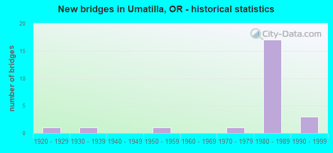
- New bridges - historical statistics
- 11920-1929
- 11930-1939
- 11950-1959
- 11970-1979
- 171980-1989
- 31990-1999

- Reconstructed bridges - Historical Statistics
- 11950-1959
- 01960-1969
- 01970-1979
- 11980-1989
- 11990-1999


- Bridge Condition - Deck
- 5.9%Very good
- 35.3%Good
- 58.8%Satisfactory

- Bridge Condition - Superstructure
- 35.3%Very good
- 23.5%Good
- 41.2%Satisfactory

- Bridge Condition - Substructure
- 17.6%Very good
- 47.1%Good
- 35.3%Satisfactory

- Bridge Condition - Channel
- 77.8%Very good
- 11.1%Good
- 11.1%Satisfactory
Find on map >> Show street view
Structure Number: 17PIE0002, Location: CANAL STA 39+17.02 (Lat: 45.921953, Lng: -119.307589), Route carried "on" structure: ServiceOther road , Year Built: 1992, Status: Open, Structure Length: 0.97m (3.18ft), Average Daily Traffic: 1 (year 2020), Truck Traffic: 40%, Average Future Daily Traffic: 1 (year 2040), Design Load: HS 20, Features Intersected: UMATILLA PROJECT PHASE I, Facility Carried by Structure: SCAPPLEHORN ROAD
Minimum Vertical Clearance: 30+ m (98+ ft), Kilometerpoint: 0.000, Lanes on structure: 2, Owner: Bureau of Reclamation, Approaching Roadway Width: 7.9m (25.9ft), Skew: 2 degrees, Material/Design: Concrete continuous, Design/Construction: Slab, Number Of Spans In Main Unit: 2, Length of Maximum Span: 3.6m (11.8ft), Curb or Sidewalk Widths: Left: 0.4m (1.3ft), Right: 0.4m (1.3ft), Curb-To-Curb Width: 12.3m (40.4ft), Out-to-Out Width: 13.0m (42.7ft)
Condition: Deck: Good, Superstructure: Very good, Substructure: Very good, Channel: Very good, Inventory Rating: 90.7 metric tons, Method Used To Determine Inventory Rating: Load Factor (LF), Structural Evaluation: Equal to present desirable criteria, Deck Geometry: Superior to present desirable criteria, Waterway Adequacy: Superior to present desirable criteria, Approach Roadway Alignment: Equal to present desirable criteria, Designated Inspection Frequency: Every 24 months, Inspection Date: Febuary 2020, Deck Structure Type: Concrete Cast-file-Place
Find on map >> Show street view
Structure Number: 17PIE0005, Location: CANAL STA 68+65.17 (Lat: 45.919097, Lng: -119.318361), Route carried "on" structure: ServiceOther road , Year Built: 1992, Status: Open, Structure Length: 0.85m (2.79ft), Average Daily Traffic: 25 (year 2020), Truck Traffic: 33%, Average Future Daily Traffic: 25 (year 2040), Design Load: HS 20, Features Intersected: UMATILLA PROJECT PHASE I, Facility Carried by Structure: CONFORTH ACCESS RD
Minimum Vertical Clearance: 30+ m (98+ ft), Kilometerpoint: 0.000, Lanes on structure: 2, Owner: Bureau of Reclamation, Approaching Roadway Width: 9.8m (32.2ft), Skew: 1 degrees, Material/Design: Concrete continuous, Design/Construction: Slab, Number Of Spans In Main Unit: 2, Length of Maximum Span: 3.2m (10.5ft), Curb or Sidewalk Widths: Left: 0.4m (1.3ft), Right: 0.4m (1.3ft), Curb-To-Curb Width: 9.1m (29.9ft), Out-to-Out Width: 9.9m (32.5ft)
Condition: Deck: Very good, Superstructure: Very good, Substructure: Very good, Channel: Very good, Operating Rating: 44.4 metric tons, Method Used To Determine Operating Rating: Load Factor (LF), Inventory Rating: 26.6 metric tons, Method Used To Determine Inventory Rating: Load Factor (LF), Structural Evaluation: Equal to present minimum criteria, Deck Geometry: Better than present minimum criteria, Waterway Adequacy: Superior to present desirable criteria, Approach Roadway Alignment: Equal to present desirable criteria, Designated Inspection Frequency: Every 24 months, Inspection Date: Febuary 2020, Deck Structure Type: Concrete Cast-file-Place
Find on map >> Show street view
Structure Number: 17PIE0008, Location: CANAL STA NO 100+96.63 (Lat: 45.914592, Lng: -119.328733), Route carried "on" structure: ServiceOther road , Year Built: 1993, Status: Open, Structure Length: 0.88m (2.89ft), Average Daily Traffic: 50 (year 2020), Truck Traffic: 90%, Average Future Daily Traffic: 50 (year 2040), Design Load: HS 20, Features Intersected: UMATILLA PROJECT PHASE I, Facility Carried by Structure: ACCESS FOR SIMPLOT
Minimum Vertical Clearance: 30+ m (98+ ft), Kilometerpoint: 0.000, Lanes on structure: 2, Owner: Bureau of Reclamation, Approaching Roadway Width: 8.5m (27.9ft), Skew: 1 degrees, Material/Design: Concrete continuous, Design/Construction: Slab, Number Of Spans In Main Unit: 2, Length of Maximum Span: 3.3m (10.8ft), Curb or Sidewalk Widths: Left: 0.4m (1.3ft), Right: 0.4m (1.3ft), Curb-To-Curb Width: 7.3m (24.0ft), Out-to-Out Width: 8.1m (26.6ft)
Condition: Deck: Good, Superstructure: Very good, Substructure: Very good, Channel: Very good, Inventory Rating: 90.7 metric tons, Method Used To Determine Inventory Rating: Load Factor (LF), Structural Evaluation: Equal to present desirable criteria, Deck Geometry: Equal to present minimum criteria, Waterway Adequacy: Equal to present desirable criteria, Approach Roadway Alignment: Equal to present desirable criteria, Designated Inspection Frequency: Every 24 months, Inspection Date: Febuary 2020, Deck Structure Type: Concrete Cast-file-Place
Find on map >> Show street view
Structure Number: 624A002 1826, Location: IN CITY OF UMATILLA (Lat: 45.915689, Lng: -119.352419), Route carried "on" structure: US 730, Year Built: 1925, Year Reconstructed: 1950, Status: Open, Structure Length: 13.15m (43.14ft), Average Daily Traffic: 8,070 (year 2020), Truck Traffic: 12%, Average Future Daily Traffic: 9,200 (year 2040), Design Load: H 15, Features Intersected: UMATILLA RIVER(UMATILLA)
Minimum Vertical Clearance: 30+ m (98+ ft), Kilometerpoint: 293.866, Lanes on structure: 2, Base Highway Network: Yes, Owner: State Highway Agency, Approaching Roadway Width: 11.0m (36.1ft), Material/Design: Concrete, Design/Construction: Arch - Deck, Number Of Spans In Main Unit: 3, Number Of Approach Spans: 6, Length of Maximum Span: 33.5m (109.9ft), Curb or Sidewalk Widths: Left: 1.1m (3.6ft), Right: 1.1m (3.6ft), Curb-To-Curb Width: 9.2m (30.2ft), Out-to-Out Width: 11.9m (39.0ft)
Condition: Deck: Satisfactory, Superstructure: Satisfactory, Substructure: Satisfactory, Channel: Satisfactory, Operating Rating: 17.5 metric tons, Method Used To Determine Operating Rating: Load and Resistance Factor Rating (LRFR) rating reported by rating factor(RF) method using HL-93 loadings, Inventory Rating: 13.6 metric tons, Method Used To Determine Inventory Rating: Load and Resistance Factor Rating (LRFR) rating reported by rating factor(RF) method using HL-93 loadings, Structural Evaluation: High priority of corrective action, Deck Geometry: Meets minimum limits, Waterway Adequacy: Equal to present desirable criteria, Approach Roadway Alignment: Better than present minimum criteria, Length Of Structure Improvement: 13.40m (43.96ft), Designated Inspection Frequency: Every 24 months, Underwater Inspection Frequency: Every 36 months, Inspection Date: Febuary 2020, Underwater Inspection Date: March 2020, Bridge Improvement Cost: $1,406,000, Roadway Improvement Cost: $141,000, Total Project Cost: $2,249,000, Deck Structure Type: Concrete Cast-file-Place, Wearing Surface/Protective System: Wearing Surface: Latex Concrete
Find on map >> Show street view
Structure Number: 1628 002 1837, Location: CITY OF UMATILLA (Lat: 45.918319, Lng: -119.329931), Route carried "on" structure: US 730, Year Built: 1933, Year Reconstructed: 1993, Status: Open, Structure Length: 5.64m (18.50ft), Average Daily Traffic: 9,378 (year 2020), Truck Traffic: 12%, Average Future Daily Traffic: 10,400 (year 2040), Design Load: H 15, Features Intersected: UPRR
Minimum Vertical Clearance: 30+ m (98+ ft), Kilometerpoint: 295.636, Lanes on structure: 3, Base Highway Network: Yes, Owner: State Highway Agency, Approaching Roadway Width: 18.3m (60.0ft), Material/Design: Concrete continuous, Design/Construction: Stringer/Multi-beam, Number Of Spans In Main Unit: 4, Length of Maximum Span: 16.8m (55.1ft), Curb or Sidewalk Widths: Left: 0.0m, Right: 1.5m (4.9ft), Curb-To-Curb Width: 18.1m (59.4ft), Out-to-Out Width: 20.3m (66.6ft)
Condition: Deck: Satisfactory, Superstructure: Satisfactory, Substructure: Satisfactory, Operating Rating: 41.7 metric tons, Method Used To Determine Operating Rating: Load Factor (LF), Inventory Rating: 24.5 metric tons, Method Used To Determine Inventory Rating: Load Factor (LF), Structural Evaluation: Equal to present minimum criteria, Deck Geometry: Superior to present desirable criteria, Underclear: Meets minimum limits, Approach Roadway Alignment: Equal to present desirable criteria, Designated Inspection Frequency: Every 24 months, Inspection Date: Febuary 2020, Deck Structure Type: Concrete Cast-file-Place, Wearing Surface/Protective System: Wearing Surface: Monolithic Concrete, Deck Protection: Epoxy Coated Reinforcing
Find on map >> Show street view
Structure Number: 2230A070 00039, Location: WASHINGTON STATE LINE (Lat: 45.930700, Lng: -119.327900), Route carried "on" structure: Interstate 82, Year Built: 1955, Year Reconstructed: 1990, Status: Open, Structure Length: 103.02m (337.99ft), Average Daily Traffic: 10,454 (year 2020), Truck Traffic: 23%, Average Future Daily Traffic: 14,300 (year 2040), Design Load: HS 20, Features Intersected: COLUMBIA RIVER
Minimum Vertical Clearance: 4.85m (15.91ft), Kilometerpoint: 0.628, Lanes on structure: 2, Base Highway Network: Yes, Owner: State Highway Agency, Approaching Roadway Width: 11.6m (38.1ft), Navigation Control: Yes ( Vertical Clearance: 25.9m (85.0ft), Horizontal Clearance: 102.1m (335.0ft)), Material/Design: Steel continuous, Design/Construction: Truss - Thru, Number Of Spans In Main Unit: 5, Number Of Approach Spans: 15, Length of Maximum Span: 182.9m (600.1ft), Curb-To-Curb Width: 8.4m (27.6ft), Out-to-Out Width: 9.2m (30.2ft)
Condition: Deck: Good, Superstructure: Satisfactory, Substructure: Good, Channel: Very good, Operating Rating: 56.2 metric tons, Method Used To Determine Operating Rating: Load Factor (LF), Inventory Rating: 34.5 metric tons, Method Used To Determine Inventory Rating: Load Factor (LF), Structural Evaluation: Equal to present minimum criteria, Deck Geometry: High priority of replacement, Waterway Adequacy: Equal to present desirable criteria, Approach Roadway Alignment: Equal to present desirable criteria, Length Of Structure Improvement: 103.00m (337.93ft), Designated Inspection Frequency: Every 24 months, Critical Feature Inspection Frequency: Every 24 months, Underwater Inspection Frequency: Every 60 months, Inspection Date: June 2021, Critical Feature Inspection Date: June 2021, Underwater Inspection Date: September 2018, Bridge Improvement Cost: $10,823,000, Roadway Improvement Cost: $1,082,000, Total Project Cost: $17,317,000, Deck Structure Type: Concrete Cast-file-Place, Wearing Surface/Protective System: Wearing Surface: Latex Concrete, Deck Protection: Epoxy Coated Reinforcing
Find on map >> Show street view
Structure Number: 16424 070 0004, Location: WASHINGTON STATE LINE (Lat: 45.930531, Lng: -119.328211), Route carried "on" structure: Interstate 82, Year Built: 1988, Status: Open, Structure Length: 104.64m (343.31ft), Average Daily Traffic: 10,454 (year 2020), Truck Traffic: 23%, Average Future Daily Traffic: 14,300 (year 2040), Design Load: HS 20+Mod, Features Intersected: COLUMBIA RIVER
Minimum Vertical Clearance: 30+ m (98+ ft), Kilometerpoint: 0.644, Lanes on structure: 2, Base Highway Network: Yes, Owner: State Highway Agency, Approaching Roadway Width: 11.6m (38.1ft), Navigation Control: Yes ( Vertical Clearance: 18.3m (60.0ft), Horizontal Clearance: 121.9m (399.9ft)), Material/Design: Prestressed concrete continuous, Design/Construction: Segmental Box Girder, Number Of Spans In Main Unit: 4, Number Of Approach Spans: 4, Length of Maximum Span: 201.2m (660.1ft), Curb or Sidewalk Widths: Left: 2.4m (7.9ft), Right: 0.0m, Curb-To-Curb Width: 11.6m (38.1ft), Out-to-Out Width: 15.2m (49.9ft)
Condition: Deck: Good, Superstructure: Satisfactory, Substructure: Good, Channel: Very good, Operating Rating: 76.2 metric tons, Method Used To Determine Operating Rating: Load Factor (LF), Inventory Rating: 44.5 metric tons, Method Used To Determine Inventory Rating: Load Factor (LF), Structural Evaluation: Equal to present minimum criteria, Deck Geometry: Equal to present minimum criteria, Waterway Adequacy: Equal to present desirable criteria, Approach Roadway Alignment: Equal to present desirable criteria, Designated Inspection Frequency: Every 24 months, Underwater Inspection Frequency: Every 60 months, Inspection Date: May 2020, Underwater Inspection Date: September 2018, Deck Structure Type: Concrete Cast-file-Place, Wearing Surface/Protective System: Wearing Surface: Latex Concrete, Deck Protection: Epoxy Coated Reinforcing
Find on map >> Show street view
Structure Number: 16437 070 00061, Location: 0.6 MI. S. COLUMBIA RIVER (Lat: 45.923469, Lng: -119.324069), Route carried "on" structure: Interstate 82, Year Built: 1985, Status: Open, Structure Length: 6.58m (21.59ft), Average Daily Traffic: 7,666 (year 2020), Truck Traffic: 21%, Average Future Daily Traffic: 12,200 (year 2040), Design Load: HS 25 or greater, Features Intersected: THIRD STREET
Minimum Vertical Clearance: 30+ m (98+ ft), Kilometerpoint: 0.982, Lanes on structure: 2, Lanes under structure: 2, Base Highway Network: Yes, Owner: State Highway Agency, Approaching Roadway Width: 12.8m (42.0ft), Skew: 1 degrees, Material/Design: Prestressed concrete continuous, Design/Construction: Stringer/Multi-beam, Number Of Spans In Main Unit: 3, Length of Maximum Span: 26.5m (86.9ft), Curb-To-Curb Width: 12.8m (42.0ft), Out-to-Out Width: 13.9m (45.6ft)
Condition: Deck: Satisfactory, Superstructure: Good, Substructure: Satisfactory, Operating Rating: 33.4 metric tons, Method Used To Determine Operating Rating: Load and Resistance Factor Rating (LRFR) rating reported by rating factor(RF) method using HL-93 loadings, Inventory Rating: 25.6 metric tons, Method Used To Determine Inventory Rating: Load and Resistance Factor Rating (LRFR) rating reported by rating factor(RF) method using HL-93 loadings, Structural Evaluation: Equal to present minimum criteria, Deck Geometry: Equal to present desirable criteria, Underclear: Somewhat better than minimum adequacy, Approach Roadway Alignment: Equal to present desirable criteria, Designated Inspection Frequency: Every 24 months, Inspection Date: September 2020, Deck Structure Type: Concrete Cast-file-Place, Wearing Surface/Protective System: Wearing Surface: Monolithic Concrete, Deck Protection: Epoxy Coated Reinforcing
Find on map >> Show street view
Structure Number: 16438 070 00061, Location: 0.6 S. COLUMBIA RIVER (Lat: 45.923381, Lng: -119.324481), Route carried "on" structure: Interstate 82, Year Built: 1985, Status: Open, Structure Length: 6.58m (21.59ft), Average Daily Traffic: 7,666 (year 2020), Truck Traffic: 21%, Average Future Daily Traffic: 12,200 (year 2040), Design Load: HS 25 or greater, Features Intersected: THIRD STREET
Minimum Vertical Clearance: 30+ m (98+ ft), Kilometerpoint: 0.982, Lanes on structure: 2, Lanes under structure: 2, Base Highway Network: Yes, Owner: State Highway Agency, Approaching Roadway Width: 12.2m (40.0ft), Skew: 1 degrees, Material/Design: Prestressed concrete continuous, Design/Construction: Stringer/Multi-beam, Number Of Spans In Main Unit: 3, Length of Maximum Span: 26.5m (86.9ft), Curb-To-Curb Width: 12.8m (42.0ft), Out-to-Out Width: 13.9m (45.6ft)
Condition: Deck: Satisfactory, Superstructure: Very good, Substructure: Satisfactory, Operating Rating: 34.3 metric tons, Method Used To Determine Operating Rating: Load and Resistance Factor Rating (LRFR) rating reported by rating factor(RF) method using HL-93 loadings, Inventory Rating: 26.6 metric tons, Method Used To Determine Inventory Rating: Load and Resistance Factor Rating (LRFR) rating reported by rating factor(RF) method using HL-93 loadings, Structural Evaluation: Equal to present minimum criteria, Deck Geometry: Equal to present desirable criteria, Underclear: Somewhat better than minimum adequacy, Approach Roadway Alignment: Equal to present desirable criteria, Designated Inspection Frequency: Every 24 months, Inspection Date: September 2020, Deck Structure Type: Concrete Cast-file-Place, Wearing Surface/Protective System: Wearing Surface: Monolithic Concrete, Deck Protection: Epoxy Coated Reinforcing
Find on map >> Show street view
Structure Number: 16439 070 00076, Location: 0.8 MI. S. COLUMBIA RIVER (Lat: 45.921461, Lng: -119.322611), Route carried "on" structure: Interstate 82, Year Built: 1985, Status: Open, Structure Length: 5.78m (18.96ft), Average Daily Traffic: 7,666 (year 2020), Truck Traffic: 21%, Average Future Daily Traffic: 12,200 (year 2040), Design Load: HS 25 or greater, Features Intersected: UPRR
Minimum Vertical Clearance: 30+ m (98+ ft), Kilometerpoint: 1.223, Lanes on structure: 3, Base Highway Network: Yes, Owner: State Highway Agency, Approaching Roadway Width: 14.6m (47.9ft), Skew: 1 degrees, Material/Design: Prestressed concrete, Design/Construction: Stringer/Multi-beam, Number Of Spans In Main Unit: 3, Length of Maximum Span: 21.3m (69.9ft), Curb-To-Curb Width: 14.6m (47.9ft), Out-to-Out Width: 15.7m (51.5ft)
Condition: Deck: Good, Superstructure: Very good, Substructure: Good, Operating Rating: 42.4 metric tons, Method Used To Determine Operating Rating: Load and Resistance Factor Rating (LRFR) rating reported by rating factor(RF) method using HL-93 loadings, Inventory Rating: 32.7 metric tons, Method Used To Determine Inventory Rating: Load and Resistance Factor Rating (LRFR) rating reported by rating factor(RF) method using HL-93 loadings, Structural Evaluation: Better than present minimum criteria, Deck Geometry: Meets minimum limits, Underclear: Superior to present desirable criteria, Approach Roadway Alignment: Equal to present desirable criteria, Designated Inspection Frequency: Every 24 months, Inspection Date: September 2020, Deck Structure Type: Concrete Cast-file-Place, Wearing Surface/Protective System: Wearing Surface: Monolithic Concrete, Deck Protection: Epoxy Coated Reinforcing
Find on map >> Show street view
Structure Number: 16440 070 00076, Location: 0.8 MI. S. COLUMBIA RIVER (Lat: 45.921389, Lng: -119.323061), Route carried "on" structure: Interstate 82, Year Built: 1985, Status: Open, Structure Length: 5.96m (19.55ft), Average Daily Traffic: 7,666 (year 2020), Truck Traffic: 21%, Average Future Daily Traffic: 12,200 (year 2040), Design Load: HS 25 or greater, Features Intersected: UPRR
Minimum Vertical Clearance: 30+ m (98+ ft), Kilometerpoint: 1.223, Lanes on structure: 2, Base Highway Network: Yes, Owner: State Highway Agency, Approaching Roadway Width: 12.8m (42.0ft), Skew: 1 degrees, Material/Design: Prestressed concrete, Design/Construction: Stringer/Multi-beam, Number Of Spans In Main Unit: 3, Length of Maximum Span: 21.3m (69.9ft), Curb-To-Curb Width: 12.8m (42.0ft), Out-to-Out Width: 16.8m (55.1ft)
Condition: Deck: Satisfactory, Superstructure: Very good, Substructure: Good, Operating Rating: 39.9 metric tons, Method Used To Determine Operating Rating: Load and Resistance Factor Rating (LRFR) rating reported by rating factor(RF) method using HL-93 loadings, Inventory Rating: 30.8 metric tons, Method Used To Determine Inventory Rating: Load and Resistance Factor Rating (LRFR) rating reported by rating factor(RF) method using HL-93 loadings, Structural Evaluation: Better than present minimum criteria, Deck Geometry: Equal to present desirable criteria, Underclear: Superior to present desirable criteria, Approach Roadway Alignment: Equal to present desirable criteria, Designated Inspection Frequency: Every 24 months, Inspection Date: September 2020, Deck Structure Type: Concrete Cast-file-Place, Wearing Surface/Protective System: Wearing Surface: Monolithic Concrete, Deck Protection: Epoxy Coated Reinforcing
Find on map >> Show street view
Structure Number: 16441 070 001, Location: 1.0 MI. S. WA STATE LINE (Lat: 45.918181, Lng: -119.320981), Route carried "on" structure: Interstate 82, Year Built: 1985, Status: Open, Structure Length: 6.67m (21.88ft), Average Daily Traffic: 7,666 (year 2020), Truck Traffic: 21%, Average Future Daily Traffic: 12,200 (year 2040), Design Load: HS 25 or greater, Features Intersected: HWY 2 (UMATILLA)
Minimum Vertical Clearance: 30+ m (98+ ft), Kilometerpoint: 1.609, Lanes on structure: 2, Lanes under structure: 5, Base Highway Network: Yes, Owner: State Highway Agency, Approaching Roadway Width: 12.8m (42.0ft), Material/Design: Concrete continuous, Design/Construction: Box Beam or Girders - Multiple, Number Of Spans In Main Unit: 3, Length of Maximum Span: 34.1m (111.9ft), Curb-To-Curb Width: 13.7m (44.9ft), Out-to-Out Width: 13.9m (45.6ft)
Condition: Deck: Satisfactory, Superstructure: Satisfactory, Substructure: Good, Operating Rating: 23.7 metric tons, Method Used To Determine Operating Rating: Load and Resistance Factor Rating (LRFR) rating reported by rating factor(RF) method using HL-93 loadings, Inventory Rating: 18.1 metric tons, Method Used To Determine Inventory Rating: Load and Resistance Factor Rating (LRFR) rating reported by rating factor(RF) method using HL-93 loadings, Structural Evaluation: Meets minimum limits, Deck Geometry: Superior to present desirable criteria, Underclear: Equal to present minimum criteria, Approach Roadway Alignment: Equal to present desirable criteria, Designated Inspection Frequency: Every 24 months, Inspection Date: Febuary 2021, Deck Structure Type: Concrete Cast-file-Place, Wearing Surface/Protective System: Wearing Surface: Monolithic Concrete, Deck Protection: Epoxy Coated Reinforcing
Find on map >> Show street view
Structure Number: 16442 070 001, Location: 1.0 MI. S. WA STATE LINE (Lat: 45.918189, Lng: -119.321511), Route carried "on" structure: Interstate 82, Year Built: 1985, Status: Open, Structure Length: 6.67m (21.88ft), Average Daily Traffic: 7,666 (year 2020), Truck Traffic: 21%, Average Future Daily Traffic: 12,200 (year 2040), Design Load: HS 25 or greater, Features Intersected: HWY 2 (UMATILLA)
Minimum Vertical Clearance: 30+ m (98+ ft), Kilometerpoint: 1.609, Lanes on structure: 2, Lanes under structure: 5, Base Highway Network: Yes, Owner: State Highway Agency, Approaching Roadway Width: 12.8m (42.0ft), Material/Design: Concrete continuous, Design/Construction: Box Beam or Girders - Multiple, Number Of Spans In Main Unit: 3, Length of Maximum Span: 34.1m (111.9ft), Curb-To-Curb Width: 12.8m (42.0ft), Out-to-Out Width: 13.9m (45.6ft)
Condition: Deck: Satisfactory, Superstructure: Satisfactory, Substructure: Good, Operating Rating: 23.7 metric tons, Method Used To Determine Operating Rating: Load and Resistance Factor Rating (LRFR) rating reported by rating factor(RF) method using HL-93 loadings, Inventory Rating: 18.1 metric tons, Method Used To Determine Inventory Rating: Load and Resistance Factor Rating (LRFR) rating reported by rating factor(RF) method using HL-93 loadings, Structural Evaluation: Meets minimum limits, Deck Geometry: Equal to present desirable criteria, Underclear: Equal to present minimum criteria, Approach Roadway Alignment: Equal to present desirable criteria, Designated Inspection Frequency: Every 24 months, Inspection Date: Febuary 2021, Deck Structure Type: Concrete Cast-file-Place, Wearing Surface/Protective System: Wearing Surface: Monolithic Concrete, Deck Protection: Epoxy Coated Reinforcing
Find on map >> Show street view
Structure Number: 16443 070 00167, Location: 1.65 MI. S. WA STATE LINE (Lat: 45.908700, Lng: -119.328350), Route carried "on" structure: Interstate 82, Year Built: 1985, Status: Open, Structure Length: 31.06m (101.90ft), Average Daily Traffic: 7,666 (year 2020), Truck Traffic: 21%, Average Future Daily Traffic: 12,200 (year 2040), Design Load: HS 25 or greater, Features Intersected: UMATILLA R, UPRR, CTY RD
Minimum Vertical Clearance: 30+ m (98+ ft), Kilometerpoint: 2.849, Lanes on structure: 2, Lanes under structure: 2, Base Highway Network: Yes, Owner: State Highway Agency, Approaching Roadway Width: 12.8m (42.0ft), Material/Design: Prestressed concrete, Design/Construction: Stringer/Multi-beam, Number Of Spans In Main Unit: 9, Length of Maximum Span: 40.2m (131.9ft), Curb-To-Curb Width: 12.8m (42.0ft), Out-to-Out Width: 13.7m (44.9ft)
Condition: Deck: Satisfactory, Superstructure: Good, Substructure: Satisfactory, Channel: Good, Operating Rating: 48.9 metric tons, Method Used To Determine Operating Rating: Load and Resistance Factor Rating (LRFR) rating reported by rating factor(RF) method using HL-93 loadings, Inventory Rating: 37.6 metric tons, Method Used To Determine Inventory Rating: Load and Resistance Factor Rating (LRFR) rating reported by rating factor(RF) method using HL-93 loadings, Structural Evaluation: Equal to present minimum criteria, Deck Geometry: Equal to present desirable criteria, Underclear: High priority of corrective action, Waterway Adequacy: Equal to present desirable criteria, Approach Roadway Alignment: Equal to present desirable criteria, Length Of Structure Improvement: 31.00m (101.71ft), Designated Inspection Frequency: Every 24 months, Underwater Inspection Frequency: Every 60 months, Inspection Date: Febuary 2021, Underwater Inspection Date: September 2018, Bridge Improvement Cost: $3,253,000, Roadway Improvement Cost: $325,000, Total Project Cost: $5,205,000, Deck Structure Type: Concrete Cast-file-Place, Wearing Surface/Protective System: Wearing Surface: Monolithic Concrete, Deck Protection: Epoxy Coated Reinforcing
Find on map >> Show street view
Structure Number: 16444 070 00165, Location: 1.67 MI. S. WA STATE LINE (Lat: 45.908161, Lng: -119.328211), Route carried "on" structure: Interstate 82, Year Built: 1985, Status: Open, Structure Length: 30.08m (98.69ft), Average Daily Traffic: 7,666 (year 2020), Truck Traffic: 21%, Average Future Daily Traffic: 12,200 (year 2040), Design Load: HS 25 or greater, Features Intersected: UMATILLA R, UPRR, CTY RD
Minimum Vertical Clearance: 30+ m (98+ ft), Kilometerpoint: 2.849, Lanes on structure: 2, Lanes under structure: 2, Base Highway Network: Yes, Owner: State Highway Agency, Approaching Roadway Width: 12.8m (42.0ft), Material/Design: Prestressed concrete, Design/Construction: Stringer/Multi-beam, Number Of Spans In Main Unit: 9, Length of Maximum Span: 39.0m (128.0ft), Curb-To-Curb Width: 12.8m (42.0ft), Out-to-Out Width: 13.7m (44.9ft)
Condition: Deck: Satisfactory, Superstructure: Good, Substructure: Satisfactory, Channel: Very good, Operating Rating: 48.3 metric tons, Method Used To Determine Operating Rating: Load and Resistance Factor Rating (LRFR) rating reported by rating factor(RF) method using HL-93 loadings, Inventory Rating: 37.3 metric tons, Method Used To Determine Inventory Rating: Load and Resistance Factor Rating (LRFR) rating reported by rating factor(RF) method using HL-93 loadings, Structural Evaluation: Equal to present minimum criteria, Deck Geometry: Equal to present desirable criteria, Underclear: High priority of corrective action, Waterway Adequacy: Equal to present desirable criteria, Approach Roadway Alignment: Equal to present desirable criteria, Length Of Structure Improvement: 30.00m (98.43ft), Designated Inspection Frequency: Every 24 months, Underwater Inspection Frequency: Every 60 months, Inspection Date: Febuary 2021, Underwater Inspection Date: September 2018, Bridge Improvement Cost: $3,151,000, Roadway Improvement Cost: $315,000, Total Project Cost: $5,041,000, Deck Structure Type: Concrete Cast-file-Place, Wearing Surface/Protective System: Wearing Surface: Epoxy Overlay, Deck Protection: Epoxy Coated Reinforcing
Find on map >> Show street view
Structure Number: 16447 070 00485, Location: 4.75 S. WASH. ST. LINE (Lat: 45.867081, Lng: -119.342781), Route carried "on" structure: County highway C1225, Year Built: 1986, Status: Open, Structure Length: 10.06m (33.01ft), Average Daily Traffic: 783 (year 2010), Truck Traffic: 10%, Average Future Daily Traffic: 1,037 (year 2030), Design Load: HS 25 or greater, Features Intersected: I-82 (HWY 70) MP 4.86, Facility Carried by Structure: POWERLINE RD
Minimum Vertical Clearance: 30+ m (98+ ft), Kilometerpoint: 7.838, Lanes on structure: 2, Lanes under structure: 4, Owner: State Highway Agency, Approaching Roadway Width: 11.0m (36.1ft), Skew: 4 degrees, Material/Design: Prestressed concrete continuous, Design/Construction: Box Beam or Girders - Multiple, Number Of Spans In Main Unit: 2, Length of Maximum Span: 51.8m (169.9ft), Curb-To-Curb Width: 11.0m (36.1ft), Out-to-Out Width: 11.9m (39.0ft)
Condition: Deck: Satisfactory, Superstructure: Good, Substructure: Good, Operating Rating: 32.4 metric tons, Method Used To Determine Operating Rating: Load and Resistance Factor Rating (LRFR) rating reported by rating factor(RF) method using HL-93 loadings, Inventory Rating: 24.9 metric tons, Method Used To Determine Inventory Rating: Load and Resistance Factor Rating (LRFR) rating reported by rating factor(RF) method using HL-93 loadings, Structural Evaluation: Equal to present minimum criteria, Deck Geometry: Better than present minimum criteria, Underclear: Better than present minimum criteria, Approach Roadway Alignment: Equal to present desirable criteria, Designated Inspection Frequency: Every 24 months, Inspection Date: September 2020, Deck Structure Type: Concrete Cast-file-Place, Wearing Surface/Protective System: Deck Protection: Epoxy Coated Reinforcing
Find on map >> Show street view
Structure Number: 59C270122500064, Location: 0.6 MI SE OF HWY 730 (Lat: 45.909581, Lng: -119.343875), Route carried "on" structure: County highway , Year Built: 1972, Status: Open, Structure Length: 1.43m (4.69ft), Average Daily Traffic: 2,565 (year 2020), Truck Traffic: 25%, Average Future Daily Traffic: 2,977 (year 2025), Design Load: HS 20, Features Intersected: W EXT. IRRIGATION CANAL, Facility Carried by Structure: POWERLINE RD
Minimum Vertical Clearance: 30+ m (98+ ft), Kilometerpoint: 1.030, Lanes on structure: 2, Owner: City or Municipal Highway Agency, Approaching Roadway Width: 8.1m (26.6ft), Skew: 2 degrees, Material/Design: Prestressed concrete, Design/Construction: Slab, Number Of Spans In Main Unit: 1, Length of Maximum Span: 13.7m (44.9ft), Curb or Sidewalk Widths: Left: 0.0m, Right: 1.4m (4.6ft), Curb-To-Curb Width: 10.1m (33.1ft), Out-to-Out Width: 12.3m (40.4ft)
Condition: Deck: Good, Superstructure: Satisfactory, Substructure: Good, Channel: Very good, Operating Rating: 69.9 metric tons, Method Used To Determine Operating Rating: Allowable Stress (AS), Inventory Rating: 41.7 metric tons, Method Used To Determine Inventory Rating: Allowable Stress (AS), Structural Evaluation: Equal to present minimum criteria, Deck Geometry: Meets minimum limits, Waterway Adequacy: Equal to present desirable criteria, Approach Roadway Alignment: Equal to present desirable criteria, Designated Inspection Frequency: Every 24 months, Inspection Date: November 2020, Deck Structure Type: Concrete Precast Panels, Wearing Surface/Protective System: Wearing Surface: Bituminous
Find on map >> Show street view
Structure Number: 16437 070 00061, Location: 0.6 MI. S. COLUMBIA RIVER (Lat: 45.923469, Lng: -119.324069), Route carried "under" structure: City street , Year Built: 1985, Structure Length: 0. m, Average Daily Traffic: 120 (year 2010), Truck Traffic: 3%, Features Intersected: THIRD STREET, Facility Carried by Structure: I-82 (HWY 070) WB
Minimum Vertical Clearance: 9.14m (29.99ft), Kilometerpoint: 0.000, Lanes on structure: 2, Lanes under structure: 2, Material/Design: Prestressed concrete continuous, Design/Construction: Stringer/Multi-beam, Length of Maximum Span: 26.5m (86.9ft)
Find on map >> Show street view
Structure Number: 16438 070 00061, Location: 0.6 S. COLUMBIA RIVER (Lat: 45.923381, Lng: -119.324481), Route carried "under" structure: City street , Year Built: 1985, Structure Length: 0. m, Average Daily Traffic: 120 (year 2010), Truck Traffic: 3%, Features Intersected: THIRD STREET, Facility Carried by Structure: I-82 (HWY 070) EB
Minimum Vertical Clearance: 9.14m (29.99ft), Kilometerpoint: 0.000, Lanes on structure: 2, Lanes under structure: 2, Material/Design: Prestressed concrete continuous, Design/Construction: Stringer/Multi-beam, Length of Maximum Span: 26.5m (86.9ft)
Find on map >> Show street view
Structure Number: 16441 070 001, Location: 1.0 MI. S. WA STATE LINE (Lat: 45.918181, Lng: -119.320981), Route carried "under" structure: US 84, Year Built: 1985, Structure Length: 0. m, Average Daily Traffic: 12,081 (year 2020), Truck Traffic: 31%, Features Intersected: HWY 2 (UMATILLA), Facility Carried by Structure: I-82 (HWY 070) WB
Minimum Vertical Clearance: 6.38m (20.93ft), Kilometerpoint: 296.763, Lanes on structure: 2, Lanes under structure: 5, Material/Design: Concrete continuous, Design/Construction: Box Beam or Girders - Multiple, Length of Maximum Span: 34.1m (111.9ft)
Find on map >> Show street view
Structure Number: 16442 070 001, Location: 1.0 MI. S. WA STATE LINE (Lat: 45.918189, Lng: -119.321511), Route carried "under" structure: US 84, Year Built: 1985, Structure Length: 0. m, Average Daily Traffic: 12,081 (year 2020), Truck Traffic: 31%, Features Intersected: HWY 2 (UMATILLA), Facility Carried by Structure: I-82 (HWY 070) EB
Minimum Vertical Clearance: 6.25m (20.51ft), Kilometerpoint: 296.329, Lanes on structure: 2, Lanes under structure: 5, Material/Design: Concrete continuous, Design/Construction: Box Beam or Girders - Multiple, Length of Maximum Span: 34.1m (111.9ft)
Find on map >> Show street view
Structure Number: 16443 070 00167, Location: 1.65 MI. S. WA STATE LINE (Lat: 45.908700, Lng: -119.328350), Route carried "under" structure: County highway , Year Built: 1985, Structure Length: 0. m, Average Daily Traffic: 5,060 (year 2010), Truck Traffic: 6%, Features Intersected: UMATILLA R, UPRR, CTY RD, Facility Carried by Structure: I-82 (HWY 070) WB
Minimum Vertical Clearance: 9.14m (29.99ft), Kilometerpoint: 0.000, Lanes on structure: 2, Lanes under structure: 2, Material/Design: Prestressed concrete, Design/Construction: Stringer/Multi-beam, Length of Maximum Span: 40.2m (131.9ft)
Find on map >> Show street view
Structure Number: 16444 070 00165, Location: 1.67 MI. S. WA STATE LINE (Lat: 45.908161, Lng: -119.328211), Route carried "under" structure: County highway , Year Built: 1985, Structure Length: 0. m, Average Daily Traffic: 5,060 (year 2010), Truck Traffic: 6%, Features Intersected: UMATILLA R, UPRR, CTY RD, Facility Carried by Structure: I-82 (HWY 070) EB
Minimum Vertical Clearance: 9.14m (29.99ft), Kilometerpoint: 0.000, Lanes on structure: 2, Lanes under structure: 2, Material/Design: Prestressed concrete, Design/Construction: Stringer/Multi-beam, Length of Maximum Span: 39.0m (128.0ft)
Find on map >> Show street view
Structure Number: 16447 070 00485, Location: 4.75 S. WASH. ST. LINE (Lat: 45.867081, Lng: -119.342781), Route carried "under" structure: Interstate 82, Year Built: 1986, Structure Length: 0. m, Average Daily Traffic: 14,967 (year 2020), Truck Traffic: 39%, Features Intersected: I-82 (HWY 70) MP 4.86, Facility Carried by Structure: POWERLINE RD
Minimum Vertical Clearance: 5.55m (18.21ft), Kilometerpoint: 7.821, Lanes on structure: 2, Lanes under structure: 4, Material/Design: Prestressed concrete continuous, Design/Construction: Box Beam or Girders - Multiple, Length of Maximum Span: 51.8m (169.9ft)