Bridge Statistics for University of Virginia, Virginia (VA)
Condition, Traffic, Stress, Structural Evaluation, Project Costs
- National Bridge Inventory (NBI) Statistics
- 22Number of bridges
- 207ft / 63.1mTotal length
- $736,000Total costs
- 410,826Total average daily traffic
- 28,113Total average daily truck traffic
- National Bridge Inventory (NBI) Registered Bridges for University of Virginia
- No street view available for this location
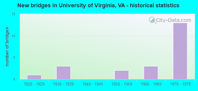
- New bridges - historical statistics
- 11920-1929
- 31930-1939
- 21950-1959
- 31960-1969
- 131970-1979

- Reconstructed bridges - Historical Statistics
- 11970-1979
- 01980-1989
- 11990-1999
- 12000-2009


- Bridge Condition - Deck
- 10.0%Very good
- 30.0%Good
- 20.0%Satisfactory
- 40.0%Fair

- Bridge Condition - Superstructure
- 10.0%Very good
- 50.0%Satisfactory
- 40.0%Fair

- Bridge Condition - Substructure
- 10.0%Good
- 50.0%Satisfactory
- 40.0%Fair

- Bridge Condition - Channel
- 12.5%Very good
- 37.5%Good
- 50.0%Satisfactory

- Bridge Condition - Culverts
- 20.0%Good
- 80.0%Satisfactory
Find on map >> Show street view
Structure Number: 468, Location: 2.34 FR 745/0.08 TO 1106 (Lat: 38.016267, Lng: -78.544747), Route carried "on" structure: US 29, Year Built: 1957, Year Reconstructed: 1970, Status: Open, Structure Length: 0.85m (2.79ft), Average Daily Traffic: 14,792 (year 2020), Truck Traffic: 10%, Average Future Daily Traffic: 20,709 (year 2040), Design Load: HS 20, Features Intersected: MOORES CREEK, Facility Carried by Structure: MONACAN TRL -NB-SB
Minimum Vertical Clearance: 30+ m (98+ ft), Kilometerpoint: 214.673, Lanes on structure: 4, Base Highway Network: Yes, Owner: State Highway Agency, Approaching Roadway Width: 14.6m (47.9ft), Skew: 2 degrees, Material/Design: Concrete, Design/Construction: Culvert, Number Of Spans In Main Unit: 3, Length of Maximum Span: 2.7m (8.9ft)
Condition: Channel: Satisfactory, Culverts: Satisfactory, Operating Rating: 89.8 metric tons, Method Used To Determine Operating Rating: Field evaluation and documented engineering judgment, Inventory Rating: 89.8 metric tons, Method Used To Determine Inventory Rating: Field evaluation and documented engineering judgment, Structural Evaluation: Equal to present minimum criteria, Waterway Adequacy: Equal to present minimum criteria, Approach Roadway Alignment: Equal to present desirable criteria, Designated Inspection Frequency: Every 24 months, Inspection Date: March 2021
Find on map >> Show street view
Structure Number: 484, Location: 1.05FR1106/3.38 TO250BUS (Lat: 38.026525, Lng: -78.528628), Route carried "on" structure: Bypass US 29, Year Built: 1970, Status: Open, Structure Length: 5.45m (17.88ft), Average Daily Traffic: 21,564 (year 2020), Truck Traffic: 10%, Average Future Daily Traffic: 30,190 (year 2040), Design Load: HS 20+Mod, Features Intersected: RTE 29 BUSS - FONTAINE, Facility Carried by Structure: MONACAN TRAIL -NBL
Minimum Vertical Clearance: 30+ m (98+ ft), Kilometerpoint: 216.459, Lanes on structure: 2, Lanes under structure: 3, Base Highway Network: Yes, Owner: State Highway Agency, Approaching Roadway Width: 7.3m (24.0ft), Skew: 2 degrees, Material/Design: Steel, Design/Construction: Stringer/Multi-beam, Number Of Spans In Main Unit: 3, Length of Maximum Span: 25.0m (82.0ft), Curb or Sidewalk Widths: Left: 0.2m (0.7ft), Right: 0.2m (0.7ft), Curb-To-Curb Width: 12.0m (39.4ft), Out-to-Out Width: 13.0m (42.7ft)
Condition: Deck: Good, Superstructure: Satisfactory, Substructure: Fair, Operating Rating: 64.4 metric tons, Method Used To Determine Operating Rating: Load and Resistance Factor (LRFR), Inventory Rating: 49.9 metric tons, Method Used To Determine Inventory Rating: Load and Resistance Factor (LRFR), Structural Evaluation: Somewhat better than minimum adequacy, Deck Geometry: Equal to present minimum criteria, Underclear: Somewhat better than minimum adequacy, Approach Roadway Alignment: Equal to present desirable criteria, Designated Inspection Frequency: Every 24 months, Inspection Date: August 2020, Deck Structure Type: Concrete Cast-file-Place
Find on map >> Show street view
Structure Number: 486, Location: 1.04FR1106/3.39TO250BUS (Lat: 38.026494, Lng: -78.528869), Route carried "on" structure: Bypass US 29, Year Built: 1970, Status: Open, Structure Length: 5.45m (17.88ft), Average Daily Traffic: 21,564 (year 2020), Truck Traffic: 10%, Average Future Daily Traffic: 30,190 (year 2040), Design Load: HS 20+Mod, Features Intersected: RTE 29 BUSS - FONTAINE, Facility Carried by Structure: MONACAN TRAIL -SBL
Minimum Vertical Clearance: 5.94m (19.49ft), Kilometerpoint: 216.443, Lanes on structure: 2, Lanes under structure: 2, Base Highway Network: Yes, Owner: State Highway Agency, Approaching Roadway Width: 11.9m (39.0ft), Skew: 2 degrees, Material/Design: Steel, Design/Construction: Stringer/Multi-beam, Number Of Spans In Main Unit: 3, Length of Maximum Span: 25.0m (82.0ft), Curb or Sidewalk Widths: Left: 0.2m (0.7ft), Right: 0.2m (0.7ft), Curb-To-Curb Width: 12.0m (39.4ft), Out-to-Out Width: 13.0m (42.7ft)
Condition: Deck: Fair, Superstructure: Fair, Substructure: Satisfactory, Operating Rating: 59.0 metric tons, Method Used To Determine Operating Rating: Load and Resistance Factor (LRFR), Inventory Rating: 45.4 metric tons, Method Used To Determine Inventory Rating: Load and Resistance Factor (LRFR), Structural Evaluation: Somewhat better than minimum adequacy, Deck Geometry: Equal to present minimum criteria, Underclear: Meets minimum limits, Approach Roadway Alignment: Equal to present desirable criteria, Designated Inspection Frequency: Every 24 months, Inspection Date: August 2020, Deck Structure Type: Concrete Cast-file-Place
Find on map >> Show street view
Structure Number: 488, Location: 0.45 FR I64/0.17 TO29BUS (Lat: 38.024442, Lng: -78.530272), Route carried "on" structure: Bypass US 29, Year Built: 1970, Status: Open, Structure Length: 0.99m (3.25ft), Average Daily Traffic: 45,774 (year 2020), Truck Traffic: 10%, Average Future Daily Traffic: 64,084 (year 2040), Design Load: HS 20, Features Intersected: MOREY CREEK, Facility Carried by Structure: MONACAN TRL -NB-SB
Minimum Vertical Clearance: 30+ m (98+ ft), Kilometerpoint: 216.201, Lanes on structure: 6, Base Highway Network: Yes, Owner: State Highway Agency, Approaching Roadway Width: 14.6m (47.9ft), Skew: 4 degrees, Material/Design: Concrete, Design/Construction: Culvert, Number Of Spans In Main Unit: 3, Length of Maximum Span: 2.4m (7.9ft)
Condition: Channel: Satisfactory, Culverts: Satisfactory, Operating Rating: 89.8 metric tons, Method Used To Determine Operating Rating: Load Factor (LF), Inventory Rating: 89.8 metric tons, Method Used To Determine Inventory Rating: Load Factor (LF), Structural Evaluation: Equal to present minimum criteria, Waterway Adequacy: Superior to present desirable criteria, Approach Roadway Alignment: Equal to present desirable criteria, Designated Inspection Frequency: Every 24 months, Inspection Date: March 2021
Find on map >> Show street view
Structure Number: 489, Location: 0.01 FR 1106 /0.40 TO I64 (Lat: 38.017383, Lng: -78.542569), Route carried "on" structure: US 29, Year Built: 1970, Status: Open, Structure Length: 1.31m (4.30ft), Average Daily Traffic: 14,792 (year 2020), Truck Traffic: 10%, Average Future Daily Traffic: 20,709 (year 2040), Design Load: HS 20, Features Intersected: MOORES CREEK, Facility Carried by Structure: MONACAN TRL -NB-SB
Minimum Vertical Clearance: 30+ m (98+ ft), Kilometerpoint: 214.818, Lanes on structure: 4, Base Highway Network: Yes, Owner: State Highway Agency, Approaching Roadway Width: 14.6m (47.9ft), Skew: 4 degrees, Material/Design: Concrete, Design/Construction: Culvert, Number Of Spans In Main Unit: 3, Length of Maximum Span: 4.6m (15.1ft)
Condition: Channel: Satisfactory, Culverts: Satisfactory, Operating Rating: 89.8 metric tons, Method Used To Determine Operating Rating: Load Factor (LF), Inventory Rating: 89.8 metric tons, Method Used To Determine Inventory Rating: Load Factor (LF), Structural Evaluation: Equal to present minimum criteria, Waterway Adequacy: Equal to present minimum criteria, Approach Roadway Alignment: Equal to present desirable criteria, Designated Inspection Frequency: Every 24 months, Inspection Date: March 2021
Find on map >> Show street view
Structure Number: 49, Location: 0.18 FR I-64/0.36 29 BUS. (Lat: 38.021839, Lng: -78.534639), Route carried "on" structure: US 29, Year Built: 1970, Status: Open, Structure Length: 0.64m (2.10ft), Average Daily Traffic: 14,792 (year 2020), Truck Traffic: 10%, Average Future Daily Traffic: 20,709 (year 2040), Design Load: HS 20+Mod, Features Intersected: BRANCH MOORES CREEK, Facility Carried by Structure: MONACAN TRL -NB-SB
Minimum Vertical Clearance: 30+ m (98+ ft), Kilometerpoint: 215.767, Lanes on structure: 6, Base Highway Network: Yes, Owner: State Highway Agency, Approaching Roadway Width: 21.9m (71.9ft), Material/Design: Concrete, Design/Construction: Culvert, Number Of Spans In Main Unit: 2, Length of Maximum Span: 3.0m (9.8ft)
Condition: Channel: Satisfactory, Culverts: Satisfactory, Operating Rating: 89.8 metric tons, Method Used To Determine Operating Rating: Load Factor (LF), Inventory Rating: 89.8 metric tons, Method Used To Determine Inventory Rating: Load Factor (LF), Structural Evaluation: Equal to present minimum criteria, Waterway Adequacy: Superior to present desirable criteria, Approach Roadway Alignment: Equal to present desirable criteria, Designated Inspection Frequency: Every 24 months, Inspection Date: March 2021
Find on map >> Show street view
Structure Number: 552, Location: 3.84 FR 637 / 1.85 TO 631 (Lat: 38.020822, Lng: -78.537492), Route carried "on" structure: Interstate 64, Year Built: 1970, Status: Open, Structure Length: 8.23m (27.00ft), Average Daily Traffic: 18,921 (year 2020), Truck Traffic: 11%, Average Future Daily Traffic: 26,489 (year 2040), Design Load: HS 20+Mod, Features Intersected: RTE 29 -MONACAN TRAIL RD
Minimum Vertical Clearance: 30+ m (98+ ft), Kilometerpoint: 190.184, Lanes on structure: 3, Lanes under structure: 6, Base Highway Network: Yes, Owner: State Highway Agency, Approaching Roadway Width: 11.3m (37.1ft), Skew: 2 degrees, Material/Design: Prestressed concrete, Design/Construction: Stringer/Multi-beam, Number Of Spans In Main Unit: 4, Length of Maximum Span: 23.2m (76.1ft), Curb or Sidewalk Widths: Left: 0.2m (0.7ft), Right: 0.2m (0.7ft), Curb-To-Curb Width: 13.5m (44.3ft), Out-to-Out Width: 14.6m (47.9ft)
Condition: Deck: Good, Superstructure: Satisfactory, Substructure: Satisfactory, Operating Rating: 89.8 metric tons, Method Used To Determine Operating Rating: Load and Resistance Factor (LRFR), Inventory Rating: 49.9 metric tons, Method Used To Determine Inventory Rating: Load and Resistance Factor (LRFR), Structural Evaluation: Equal to present minimum criteria, Deck Geometry: Meets minimum limits, Underclear: Equal to present minimum criteria, Approach Roadway Alignment: Equal to present desirable criteria, Designated Inspection Frequency: Every 24 months, Inspection Date: August 2021, Deck Structure Type: Concrete Cast-file-Place, Wearing Surface/Protective System: Wearing Surface: Latex Concrete
Find on map >> Show street view
Structure Number: 56, Location: 3.84 FR 637 / 1.85 TO 631 (Lat: 38.020983, Lng: -78.537217), Route carried "on" structure: Interstate 64, Year Built: 1970, Status: Open, Structure Length: 8.23m (27.00ft), Average Daily Traffic: 18,827 (year 2020), Truck Traffic: 11%, Average Future Daily Traffic: 26,358 (year 2040), Design Load: HS 20+Mod, Features Intersected: RTE 29 -MONACAN TRAIL RD
Minimum Vertical Clearance: 30+ m (98+ ft), Kilometerpoint: 190.103, Lanes on structure: 3, Lanes under structure: 6, Base Highway Network: Yes, Owner: State Highway Agency, Approaching Roadway Width: 11.3m (37.1ft), Skew: 2 degrees, Material/Design: Prestressed concrete, Design/Construction: Stringer/Multi-beam, Number Of Spans In Main Unit: 4, Length of Maximum Span: 23.2m (76.1ft), Curb or Sidewalk Widths: Left: 0.2m (0.7ft), Right: 0.2m (0.7ft), Curb-To-Curb Width: 13.5m (44.3ft), Out-to-Out Width: 14.6m (47.9ft)
Condition: Deck: Good, Superstructure: Satisfactory, Substructure: Fair, Operating Rating: 89.8 metric tons, Method Used To Determine Operating Rating: Load and Resistance Factor (LRFR), Inventory Rating: 49.0 metric tons, Method Used To Determine Inventory Rating: Load and Resistance Factor (LRFR), Structural Evaluation: Somewhat better than minimum adequacy, Deck Geometry: Meets minimum limits, Underclear: Equal to present minimum criteria, Approach Roadway Alignment: Equal to present desirable criteria, Designated Inspection Frequency: Every 24 months, Inspection Date: August 2021, Deck Structure Type: Concrete Cast-file-Place, Wearing Surface/Protective System: Wearing Surface: Latex Concrete
Find on map >> Show street view
Structure Number: 562, Location: 0.23 FR 29 / 1.61 TO 631 (Lat: 38.019283, Lng: -78.534364), Route carried "on" structure: Interstate 64, Year Built: 1970, Status: Open, Structure Length: 11.74m (38.52ft), Average Daily Traffic: 22,117 (year 2020), Truck Traffic: 11%, Average Future Daily Traffic: 30,964 (year 2040), Design Load: HS 20+Mod, Features Intersected: MOORES CRK/NORFOLK SO.RR
Minimum Vertical Clearance: 30+ m (98+ ft), Kilometerpoint: 190.522, Lanes on structure: 3, Base Highway Network: Yes, Owner: State Highway Agency, Approaching Roadway Width: 11.3m (37.1ft), Skew: 3 degrees, Material/Design: Steel, Design/Construction: Stringer/Multi-beam, Number Of Spans In Main Unit: 4, Length of Maximum Span: 29.4m (96.5ft), Curb or Sidewalk Widths: Left: 0.2m (0.7ft), Right: 0.2m (0.7ft), Curb-To-Curb Width: 13.6m (44.6ft), Out-to-Out Width: 14.6m (47.9ft)
Condition: Deck: Fair, Superstructure: Fair, Substructure: Satisfactory, Channel: Good, Operating Rating: 63.5 metric tons, Method Used To Determine Operating Rating: Load and Resistance Factor (LRFR), Inventory Rating: 49.0 metric tons, Method Used To Determine Inventory Rating: Load and Resistance Factor (LRFR), Structural Evaluation: Somewhat better than minimum adequacy, Deck Geometry: Meets minimum limits, Underclear: Somewhat better than minimum adequacy, Waterway Adequacy: Superior to present desirable criteria, Approach Roadway Alignment: Equal to present desirable criteria, Designated Inspection Frequency: Every 24 months, Inspection Date: October 2021, Deck Structure Type: Concrete Cast-file-Place, Wearing Surface/Protective System: Wearing Surface: Epoxy Overlay
Find on map >> Show street view
Structure Number: 563, Location: 0.23 FR 29 / 1.61 TO 631 (Lat: 38.019431, Lng: -78.534108), Route carried "on" structure: Interstate 64, Year Built: 1970, Status: Open, Structure Length: 12.04m (39.50ft), Average Daily Traffic: 22,808 (year 2020), Truck Traffic: 11%, Average Future Daily Traffic: 31,931 (year 2040), Design Load: HS 20+Mod, Features Intersected: MOORES CRK/NORFOLK SO.RR
Minimum Vertical Clearance: 30+ m (98+ ft), Kilometerpoint: 190.441, Lanes on structure: 3, Base Highway Network: Yes, Owner: State Highway Agency, Approaching Roadway Width: 11.3m (37.1ft), Skew: 2 degrees, Material/Design: Steel, Design/Construction: Stringer/Multi-beam, Number Of Spans In Main Unit: 4, Length of Maximum Span: 30.1m (98.8ft), Curb or Sidewalk Widths: Left: 0.2m (0.7ft), Right: 0.2m (0.7ft), Curb-To-Curb Width: 13.6m (44.6ft), Out-to-Out Width: 14.6m (47.9ft)
Condition: Deck: Fair, Superstructure: Fair, Substructure: Fair, Channel: Very good, Operating Rating: 62.6 metric tons, Method Used To Determine Operating Rating: Load and Resistance Factor (LRFR), Inventory Rating: 48.1 metric tons, Method Used To Determine Inventory Rating: Load and Resistance Factor (LRFR), Structural Evaluation: Somewhat better than minimum adequacy, Deck Geometry: Meets minimum limits, Underclear: Somewhat better than minimum adequacy, Waterway Adequacy: Superior to present desirable criteria, Approach Roadway Alignment: Equal to present desirable criteria, Designated Inspection Frequency: Every 24 months, Inspection Date: October 2021, Deck Structure Type: Concrete Cast-file-Place, Wearing Surface/Protective System: Wearing Surface: Epoxy Overlay
Find on map >> Show street view
Structure Number: 621, Location: .25 FR 809 & .65 WCL CHLV (Lat: 38.048375, Lng: -78.524789), Route carried "on" structure: Business US 250, Year Built: 1961, Status: Open, Structure Length: 2.62m (8.60ft), Average Daily Traffic: 12,497 (year 2018), Truck Traffic: 2%, Average Future Daily Traffic: 14,034 (year 2035), Design Load: HS 20, Features Intersected: ROUTE 29 & 250 BYPASS, Facility Carried by Structure: IVY ROAD
Minimum Vertical Clearance: 30+ m (98+ ft), Kilometerpoint: 0.032, Lanes on structure: 5, Lanes under structure: 4, Base Highway Network: Yes, Owner: State Highway Agency, Approaching Roadway Width: 12.5m (41.0ft), Skew: 22 degrees, Material/Design: Steel, Design/Construction: Stringer/Multi-beam, Number Of Spans In Main Unit: 1, Length of Maximum Span: 26.2m (86.0ft), Curb or Sidewalk Widths: Left: 0.5m (1.6ft), Right: 0.5m (1.6ft), Curb-To-Curb Width: 18.9m (62.0ft), Out-to-Out Width: 25.3m (83.0ft)
Condition: Deck: Satisfactory, Superstructure: Satisfactory, Substructure: Satisfactory, Operating Rating: 53.5 metric tons, Method Used To Determine Operating Rating: Load and Resistance Factor (LRFR), Inventory Rating: 40.8 metric tons, Method Used To Determine Inventory Rating: Load and Resistance Factor (LRFR), Structural Evaluation: Equal to present minimum criteria, Deck Geometry: Meets minimum limits, Underclear: High priority of corrective action, Approach Roadway Alignment: Equal to present desirable criteria, Length Of Structure Improvement: 1.52m (4.99ft), Designated Inspection Frequency: Every 24 months, Inspection Date: August 2020, Bridge Improvement Cost: $250,000, Roadway Improvement Cost: $10,000, Total Project Cost: $261,000, Deck Structure Type: Concrete Cast-file-Place, Wearing Surface/Protective System: Wearing Surface: Latex Concrete
Find on map >> Show street view
Structure Number: 861, Location: 0.01 FR 815/ 0.46 TO 846 (Lat: 38.044053, Lng: -78.531078), Route carried "on" structure: County highway 809, Year Built: 1950, Status: Open, Structure Length: 0.67m (2.20ft), Average Daily Traffic: 649 (year 2018), Average Future Daily Traffic: 778 (year 2040), Design Load: HS 20, Features Intersected: BR MOREY CRK.(SPILLWAY), Facility Carried by Structure: CANTERBURY ROAD
Minimum Vertical Clearance: 30+ m (98+ ft), Kilometerpoint: 1.818, Lanes on structure: 2, Owner: State Highway Agency, Approaching Roadway Width: 5.5m (18.0ft), Material/Design: Concrete, Design/Construction: Slab, Number Of Spans In Main Unit: 1, Length of Maximum Span: 6.1m (20.0ft), Curb-To-Curb Width: 8.2m (26.9ft), Out-to-Out Width: 8.9m (29.2ft)
Condition: Deck: Satisfactory, Superstructure: Satisfactory, Substructure: Satisfactory, Channel: Good, Operating Rating: 40.8 metric tons, Method Used To Determine Operating Rating: Load and Resistance Factor (LRFR), Inventory Rating: 31.8 metric tons, Method Used To Determine Inventory Rating: Load and Resistance Factor (LRFR), Structural Evaluation: Equal to present minimum criteria, Deck Geometry: Somewhat better than minimum adequacy, Waterway Adequacy: Better than present minimum criteria, Approach Roadway Alignment: Equal to present desirable criteria, Designated Inspection Frequency: Every 24 months, Inspection Date: November 2021, Deck Structure Type: Concrete Cast-file-Place, Wearing Surface/Protective System: Wearing Surface: Bituminous
Find on map >> Show street view
Structure Number: 882, Location: 0.13 FR 815 / 0.41 TO 809 (Lat: 38.044733, Lng: -78.528758), Route carried "on" structure: County highway 846, Year Built: 1932, Year Reconstructed: 2003, Status: Open, Structure Length: 0.67m (2.20ft), Average Daily Traffic: 529 (year 2012), Average Future Daily Traffic: 603 (year 2040), Design Load: HS 20, Features Intersected: BRANCH MOREY CREEK, Facility Carried by Structure: OLD FARM ROAD
Minimum Vertical Clearance: 30+ m (98+ ft), Kilometerpoint: 1.651, Lanes on structure: 2, Owner: State Highway Agency, Approaching Roadway Width: 5.5m (18.0ft), Skew: 2 degrees, Material/Design: Steel, Design/Construction: Culvert, Number Of Spans In Main Unit: 3, Length of Maximum Span: 1.8m (5.9ft)
Condition: Channel: Good, Culverts: Good, Operating Rating: 44.5 metric tons, Method Used To Determine Operating Rating: Load Factor (LF), Inventory Rating: 35.4 metric tons, Method Used To Determine Inventory Rating: Load Factor (LF), Structural Evaluation: Better than present minimum criteria, Waterway Adequacy: Equal to present minimum criteria, Approach Roadway Alignment: Equal to present desirable criteria, Designated Inspection Frequency: Every 24 months, Inspection Date: December 2020
Find on map >> Show street view
Structure Number: 20085, Location: 0000UNIV HWY0000CHANC S (Lat: 38.039481, Lng: -78.501883), Route carried "on" structure: City street , Year Built: 1921, Status: Open, Structure Length: 2.19m (7.19ft), Average Daily Traffic: 3,638 (year 2020), Truck Traffic: 2%, Average Future Daily Traffic: 5,093 (year 2040), Design Load: H 15, Features Intersected: RUGBY RD O CSX RAILWAY, Facility Carried by Structure: ROUTE 0000
Minimum Vertical Clearance: 30+ m (98+ ft), Kilometerpoint: 0.000, Lanes on structure: 3, Owner: City or Municipal Highway Agency, Approaching Roadway Width: 15.2m (49.9ft), Material/Design: Concrete, Design/Construction: Arch - Deck, Number Of Spans In Main Unit: 1, Length of Maximum Span: 21.9m (71.9ft), Curb or Sidewalk Widths: Left: 2.4m (7.9ft), Right: 1.5m (4.9ft), Curb-To-Curb Width: 11.3m (37.1ft), Out-to-Out Width: 15.8m (51.8ft)
Condition: Deck: Fair, Superstructure: Fair, Substructure: Fair, Operating Rating: 31.8 metric tons, Method Used To Determine Operating Rating: Load and Resistance Factor (LRFR), Inventory Rating: 25.2 metric tons, Method Used To Determine Inventory Rating: Load and Resistance Factor (LRFR), Structural Evaluation: Somewhat better than minimum adequacy, Deck Geometry: High priority of replacement, Underclear: High priority of replacement, Approach Roadway Alignment: Equal to present desirable criteria, Length Of Structure Improvement: 2.44m (8.01ft), Designated Inspection Frequency: Every 24 months, Inspection Date: September 2021, Bridge Improvement Cost: $400,000, Roadway Improvement Cost: $50,000, Total Project Cost: $475,000
Find on map >> Show street view
Structure Number: 20101, Location: 0.01NECOMB-R/0.30ALDERM-R (Lat: 38.033717, Lng: -78.509014), Route carried "on" structure: State highway 302, Year Built: 1931, Year Reconstructed: 2013, Status: Open, Structure Length: 2.03m (6.66ft), Average Daily Traffic: 2,479 (year 2014), Average Future Daily Traffic: 2,739 (year 2035), Design Load: HS 20+Mod, Features Intersected: ROUTE 29B-EMMET STREET, Facility Carried by Structure: MCCORMICK ROAD
Minimum Vertical Clearance: 30+ m (98+ ft), Kilometerpoint: 1.352, Lanes on structure: 2, Lanes under structure: 3, Owner: State Agenciy, Maintenance Responsibility: State Highway Agency, Approaching Roadway Width: 8.2m (26.9ft), Material/Design: Prestressed concrete, Design/Construction: Slab, Number Of Spans In Main Unit: 1, Length of Maximum Span: 20.3m (66.6ft), Curb or Sidewalk Widths: Left: 1.5m (4.9ft), Right: 2.4m (7.9ft), Curb-To-Curb Width: 8.2m (26.9ft), Out-to-Out Width: 12.8m (42.0ft)
Condition: Deck: Very good, Superstructure: Very good, Substructure: Good, Operating Rating: 70.8 metric tons, Method Used To Determine Operating Rating: Load and Resistance Factor (LRFR), Inventory Rating: 54.4 metric tons, Method Used To Determine Inventory Rating: Load and Resistance Factor (LRFR), Structural Evaluation: Better than present minimum criteria, Deck Geometry: High priority of corrective action, Underclear: High priority of corrective action, Approach Roadway Alignment: Better than present minimum criteria, Designated Inspection Frequency: Every 24 months, Inspection Date: May 2020, Deck Structure Type: Other, Wearing Surface/Protective System: Wearing Surface: Latex Concrete, Deck Protection: Epoxy Coated Reinforcing
Find on map >> Show street view
Structure Number: 484, Location: 1.05FR1106/3.38 TO250BUS (Lat: 38.026525, Lng: -78.528628), Route carried "under" structure: Business US 29, Year Built: 1970, Structure Length: 0. m, Average Daily Traffic: 14,220 (year 2008), Truck Traffic: 1%, Features Intersected: RTE 29 BUSS - FONTAINE, Facility Carried by Structure: MONACAN TRAIL -NBL
Minimum Vertical Clearance: 5.00m (16.40ft), Kilometerpoint: 0.113, Lanes on structure: 2, Lanes under structure: 3, Material/Design: Steel, Design/Construction: Stringer/Multi-beam, Length of Maximum Span: 25.0m (82.0ft)
Find on map >> Show street view
Structure Number: 486, Location: 1.04FR1106/3.39TO250BUS (Lat: 38.026494, Lng: -78.528869), Route carried "under" structure: Business US 29, Year Built: 1970, Structure Length: 0. m, Average Daily Traffic: 14,220 (year 2008), Truck Traffic: 1%, Features Intersected: RTE 29 BUSS - FONTAINE, Facility Carried by Structure: MONACAN TRAIL -SBL
Minimum Vertical Clearance: 5.94m (19.49ft), Kilometerpoint: 0.064, Lanes on structure: 2, Lanes under structure: 2, Material/Design: Steel, Design/Construction: Stringer/Multi-beam, Length of Maximum Span: 25.0m (82.0ft)
Find on map >> Show street view
Structure Number: 552, Location: 3.84 FR 637 / 1.85 TO 631 (Lat: 38.020822, Lng: -78.537492), Route carried "under" structure: US 29, Year Built: 1970, Structure Length: 0. m, Average Daily Traffic: 14,670 (year 2008), Truck Traffic: 6%, Features Intersected: RTE 29 -MONACAN TRAIL RD, Facility Carried by Structure: INTERSTATE 64 -EBL
Minimum Vertical Clearance: 5.56m (18.24ft), Kilometerpoint: 215.445, Lanes on structure: 3, Lanes under structure: 6, Material/Design: Prestressed concrete, Design/Construction: Stringer/Multi-beam, Length of Maximum Span: 23.2m (76.1ft)
Find on map >> Show street view
Structure Number: 56, Location: 3.84 FR 637 / 1.85 TO 631 (Lat: 38.020983, Lng: -78.537217), Route carried "under" structure: US 29, Year Built: 1970, Structure Length: 0. m, Average Daily Traffic: 14,670 (year 2008), Truck Traffic: 6%, Features Intersected: RTE 29 -MONACAN TRAIL RD, Facility Carried by Structure: INTERSTATE 64 -WBL
Minimum Vertical Clearance: 5.46m (17.91ft), Kilometerpoint: 215.477, Lanes on structure: 3, Lanes under structure: 6, Material/Design: Prestressed concrete, Design/Construction: Stringer/Multi-beam, Length of Maximum Span: 23.2m (76.1ft)
Find on map >> Show street view
Structure Number: 621, Location: .25 FR 809 & .65 WCL CHLV (Lat: 38.048375, Lng: -78.524789), Route carried "under" structure: Bypass US 29, Year Built: 1961, Structure Length: 0. m, Average Daily Traffic: 49,356 (year 2008), Truck Traffic: 3%, Features Intersected: ROUTE 29 & 250 BYPASS, Facility Carried by Structure: IVY ROAD
Minimum Vertical Clearance: 5.96m (19.55ft), Kilometerpoint: 149.444, Lanes on structure: 5, Lanes under structure: 4, Material/Design: Steel, Design/Construction: Stringer/Multi-beam, Length of Maximum Span: 26.2m (86.0ft)
Find on map >> Show street view
Structure Number: 638, Location: 0.66 FR 250 /0.06 TO 855 (Lat: 38.049611, Lng: -78.524411), Route carried "under" structure: Bypass US 29, Year Built: 1961, Structure Length: 0. m, Average Daily Traffic: 49,356 (year 2008), Truck Traffic: 3%, Features Intersected: ROUTE 29 & 250 BYPASS, Facility Carried by Structure: OLD IVY ROAD
Minimum Vertical Clearance: 4.71m (15.45ft), Kilometerpoint: 149.589, Lanes on structure: 2, Lanes under structure: 4, Material/Design: Steel continuous, Design/Construction: Stringer/Multi-beam, Length of Maximum Span: 21.9m (71.9ft)
Find on map >> Show street view
Structure Number: 20101, Location: 0.01NECOMB-R/0.30ALDERM-R (Lat: 38.033717, Lng: -78.509014), Route carried "under" structure: US 29, Year Built: 1931, Structure Length: 0. m, Average Daily Traffic: 18,591 (year 2008), Truck Traffic: 2%, Features Intersected: ROUTE 29B-EMMET STREET, Facility Carried by Structure: MCCORMICK ROAD
Minimum Vertical Clearance: 4.57m (14.99ft), Kilometerpoint: 2.574, Lanes on structure: 2, Lanes under structure: 3, Material/Design: Prestressed concrete, Design/Construction: Slab, Length of Maximum Span: 20.3m (66.6ft)