Bridge Statistics for White Bear Lake, Minnesota (MN)
Condition, Traffic, Stress, Structural Evaluation, Project Costs
- National Bridge Inventory (NBI) Statistics
- 13Number of bridges
- 141ft / 43.1mTotal length
- $1,006,000,000Total costs
- 480,736Total average daily traffic
- 22,382Total average daily truck traffic
- National Bridge Inventory (NBI) Registered Bridges for White Bear Lake
- No street view available for this location
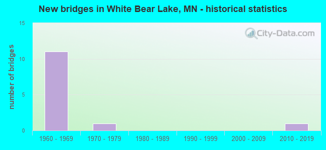
- New bridges - historical statistics
- 111960-1969
- 11970-1979
- 12010-2019


- Bridge Condition - Deck
- 71.4%Good
- 28.6%Satisfactory

- Bridge Condition - Superstructure
- 28.6%Very good
- 42.9%Good
- 28.6%Satisfactory

- Bridge Condition - Substructure
- 71.4%Good
- 14.3%Satisfactory
- 14.3%Fair
Find on map >> Show street view
Structure Number: 62079, Location: 0.2 MI E OF JCT TH 61 (Lat: 45.050297, Lng: -93.032708), Route carried "on" structure: County highway 15, Year Built: 1977, Status: Open, Structure Length: 4.69m (15.39ft), Average Daily Traffic: 13,700 (year 2017), Truck Traffic: 2%, Average Future Daily Traffic: 13,700 (year 2039), Design Load: HS 20, Features Intersected: BNSF RR
Minimum Vertical Clearance: 30+ m (98+ ft), Kilometerpoint: 0.000, Lanes on structure: 4, Owner: County Highway Agency, Approaching Roadway Width: 18.3m (60.0ft), Skew: 1 degrees, Material/Design: Prestressed concrete, Design/Construction: Stringer/Multi-beam, Number Of Spans In Main Unit: 3, Length of Maximum Span: 15.5m (50.9ft), Curb or Sidewalk Widths: Left: 3.0m (9.8ft), Right: 3.7m (12.1ft), Curb-To-Curb Width: 18.9m (62.0ft), Out-to-Out Width: 26.3m (86.3ft)
Condition: Deck: Good, Superstructure: Good, Substructure: Good, Operating Rating: 50.0 metric tons, Method Used To Determine Operating Rating: Load Factor (LF), Inventory Rating: 30.0 metric tons, Method Used To Determine Inventory Rating: Load Factor (LF), Structural Evaluation: Better than present minimum criteria, Deck Geometry: Equal to present minimum criteria, Underclear: Superior to present desirable criteria, Approach Roadway Alignment: Equal to present desirable criteria, Designated Inspection Frequency: Every 24 months, Inspection Date: November 2021, Deck Structure Type: Concrete Cast-file-Place, Wearing Surface/Protective System: Wearing Surface: Low Slump Concrete, Deck Protection: Epoxy Coated Reinforcing
Find on map >> Show street view
Structure Number: 62092, Location: 0.5 MI NE OF JCT TH 244 (Lat: 45.056678, Lng: -93.030931), Route carried "on" structure: US 61, Year Built: 2010, Status: Open, Structure Length: 7.48m (24.54ft), Average Daily Traffic: 26,000 (year 2019), Truck Traffic: 1%, Average Future Daily Traffic: 25,000 (year 2039), Design Load: HL 93, Features Intersected: BNSF RR
Minimum Vertical Clearance: 30+ m (98+ ft), Kilometerpoint: 0.000, Lanes on structure: 4, Owner: State Highway Agency, Approaching Roadway Width: 24.4m (80.1ft), Skew: 35 degrees, Material/Design: Prestressed concrete, Design/Construction: Stringer/Multi-beam, Number Of Spans In Main Unit: 3, Length of Maximum Span: 24.2m (79.4ft), Curb-To-Curb Width: 23.2m (76.1ft), Out-to-Out Width: 24.9m (81.7ft)
Condition: Deck: Good, Superstructure: Very good, Substructure: Good, Operating Rating: 68.2 metric tons, Method Used To Determine Operating Rating: Load Factor (LF), Inventory Rating: 40.8 metric tons, Method Used To Determine Inventory Rating: Load Factor (LF), Structural Evaluation: Better than present minimum criteria, Deck Geometry: Superior to present desirable criteria, Underclear: Equal to present desirable criteria, Approach Roadway Alignment: Equal to present desirable criteria, Designated Inspection Frequency: Every 24 months, Inspection Date: May 2020, Deck Structure Type: Concrete Cast-file-Place, Wearing Surface/Protective System: Wearing Surface: Monolithic Concrete, Deck Protection: Epoxy Coated Reinforcing
Find on map >> Show street view
Structure Number: 62825, Location: 1.2 MI E OF JCT TH 61 (Lat: 45.037467, Lng: -93.017722), Route carried "on" structure: Interstate 694, Year Built: 1969, Status: Open, Structure Length: 4.95m (16.24ft), Average Daily Traffic: 40,000 (year 2017), Truck Traffic: 7%, Average Future Daily Traffic: 40,000 (year 2039), Design Load: HS 20+Mod, Features Intersected: WHITE BEAR AVE (CSAH 65)
Minimum Vertical Clearance: 30+ m (98+ ft), Kilometerpoint: 0.000, Lanes on structure: 2, Lanes under structure: 4, Base Highway Network: Yes, Owner: State Highway Agency, Approaching Roadway Width: 11.3m (37.1ft), Material/Design: Prestressed concrete, Design/Construction: Stringer/Multi-beam, Number Of Spans In Main Unit: 3, Length of Maximum Span: 25.2m (82.7ft), Curb-To-Curb Width: 12.3m (40.4ft), Out-to-Out Width: 13.6m (44.6ft)
Condition: Deck: Good, Superstructure: Good, Substructure: Good, Operating Rating: 67.8 metric tons, Method Used To Determine Operating Rating: Load Factor (LF), Inventory Rating: 23.3 metric tons, Method Used To Determine Inventory Rating: Load Factor (LF), Structural Evaluation: Somewhat better than minimum adequacy, Deck Geometry: Better than present minimum criteria, Underclear: Meets minimum limits, Approach Roadway Alignment: Equal to present desirable criteria, Length Of Structure Improvement: 1.65m (5.41ft), Designated Inspection Frequency: Every 24 months, Inspection Date: August 2021, Bridge Improvement Cost: $791,000,000, Total Project Cost: $503,000,000, Deck Structure Type: Concrete Cast-file-Place, Wearing Surface/Protective System: Wearing Surface: Low Slump Concrete
Find on map >> Show street view
Structure Number: 62826, Location: 1.2 MI E OF JCT TH 61 (Lat: 45.037211, Lng: -93.017700), Route carried "on" structure: Interstate 694, Year Built: 1969, Status: Open, Structure Length: 4.95m (16.24ft), Average Daily Traffic: 38,500 (year 2019), Truck Traffic: 7%, Average Future Daily Traffic: 40,000 (year 2039), Design Load: HS 20, Features Intersected: WHITE BEAR AVE (CSAH 65)
Minimum Vertical Clearance: 30+ m (98+ ft), Kilometerpoint: 0.000, Lanes on structure: 2, Lanes under structure: 4, Base Highway Network: Yes, Owner: State Highway Agency, Approaching Roadway Width: 11.3m (37.1ft), Material/Design: Prestressed concrete, Design/Construction: Stringer/Multi-beam, Number Of Spans In Main Unit: 3, Length of Maximum Span: 25.2m (82.7ft), Curb-To-Curb Width: 12.3m (40.4ft), Out-to-Out Width: 13.6m (44.6ft)
Condition: Deck: Good, Superstructure: Good, Substructure: Satisfactory, Operating Rating: 67.8 metric tons, Method Used To Determine Operating Rating: Load Factor (LF), Inventory Rating: 23.3 metric tons, Method Used To Determine Inventory Rating: Load Factor (LF), Structural Evaluation: Somewhat better than minimum adequacy, Deck Geometry: Better than present minimum criteria, Underclear: Meets minimum limits, Approach Roadway Alignment: Equal to present desirable criteria, Length Of Structure Improvement: 1.65m (5.41ft), Designated Inspection Frequency: Every 24 months, Inspection Date: August 2021, Bridge Improvement Cost: $791,000,000, Total Project Cost: $503,000,000, Deck Structure Type: Concrete Cast-file-Place, Wearing Surface/Protective System: Wearing Surface: Low Slump Concrete
Find on map >> Show street view
Structure Number: 62827, Location: AT THE JCT TH 120; 694 (Lat: 45.034167, Lng: -92.984831), Route carried "on" structure: State highway 120, Year Built: 1969, Status: Open, Structure Length: 5.43m (17.81ft), Average Daily Traffic: 15,436 (year 2019), Truck Traffic: 3%, Average Future Daily Traffic: 15,500 (year 2039), Design Load: HS 20, Features Intersected: I 694
Minimum Vertical Clearance: 30+ m (98+ ft), Kilometerpoint: 0.000, Lanes on structure: 4, Lanes under structure: 4, Owner: State Highway Agency, Approaching Roadway Width: 18.9m (62.0ft), Skew: 21 degrees, Material/Design: Prestressed concrete, Design/Construction: Stringer/Multi-beam, Number Of Spans In Main Unit: 2, Length of Maximum Span: 26.5m (86.9ft), Curb or Sidewalk Widths: Left: 1.5m (4.9ft), Right: 1.5m (4.9ft), Curb-To-Curb Width: 17.1m (56.1ft), Out-to-Out Width: 25.8m (84.6ft)
Condition: Deck: Satisfactory, Superstructure: Satisfactory, Substructure: Fair, Operating Rating: 71.5 metric tons, Method Used To Determine Operating Rating: Load Factor (LF), Inventory Rating: 25.7 metric tons, Method Used To Determine Inventory Rating: Load Factor (LF), Structural Evaluation: Somewhat better than minimum adequacy, Deck Geometry: Somewhat better than minimum adequacy, Underclear: Meets minimum limits, Approach Roadway Alignment: Better than present minimum criteria, Designated Inspection Frequency: Every 24 months, Inspection Date: August 2021, Deck Structure Type: Concrete Cast-file-Place, Wearing Surface/Protective System: Wearing Surface: Low Slump Concrete
Find on map >> Show street view
Structure Number: 62834, Location: 2.8 MI N OF E JCT TH 694 (Lat: 45.079278, Lng: -93.052842), Route carried "on" structure: County highway 96, Year Built: 1966, Year Reconstructed: 2015, Status: Open, Structure Length: 6.07m (19.91ft), Average Daily Traffic: 30,000 (year 2015), Truck Traffic: 3%, Average Future Daily Traffic: 30,000 (year 2039), Design Load: HL 93, Features Intersected: I 35E
Minimum Vertical Clearance: 30+ m (98+ ft), Kilometerpoint: 0.000, Lanes on structure: 5, Lanes under structure: 4, Owner: State Highway Agency, Approaching Roadway Width: 23.2m (76.1ft), Skew: 20 degrees, Material/Design: Prestressed concrete, Design/Construction: Stringer/Multi-beam, Number Of Spans In Main Unit: 4, Length of Maximum Span: 17.9m (58.7ft), Curb or Sidewalk Widths: Left: 0.8m (2.6ft), Right: 0.8m (2.6ft), Curb-To-Curb Width: 21.3m (69.9ft), Out-to-Out Width: 26.2m (86.0ft)
Condition: Deck: Good, Superstructure: Very good, Substructure: Good, Operating Rating: 63.5 metric tons, Method Used To Determine Operating Rating: Load and Resistance Factor Rating (LRFR) rating reported by rating factor(RF) method using HL-93 loadings, Inventory Rating: 48.9 metric tons, Method Used To Determine Inventory Rating: Load and Resistance Factor Rating (LRFR) rating reported by rating factor(RF) method using HL-93 loadings, Structural Evaluation: Better than present minimum criteria, Deck Geometry: Somewhat better than minimum adequacy, Underclear: Meets minimum limits, Approach Roadway Alignment: Equal to present desirable criteria, Designated Inspection Frequency: Every 24 months, Inspection Date: May 2020, Deck Structure Type: Concrete Cast-file-Place, Wearing Surface/Protective System: Wearing Surface: Epoxy Overlay, Deck Protection: Epoxy Coated Reinforcing
Find on map >> Show street view
Structure Number: 62837, Location: 1.8 MI E OF JCT TH 61 (Lat: 45.036578, Lng: -93.005181), Route carried "on" structure: County highway 68, Year Built: 1969, Status: Open, Structure Length: 9.51m (31.20ft), Average Daily Traffic: 5,700 (year 2016), Average Future Daily Traffic: 5,700 (year 2039), Design Load: HS 20, Features Intersected: I 694
Minimum Vertical Clearance: 30+ m (98+ ft), Kilometerpoint: 0.000, Lanes on structure: 4, Lanes under structure: 4, Owner: State Highway Agency, Approaching Roadway Width: 17.1m (56.1ft), Material/Design: Prestressed concrete, Design/Construction: Stringer/Multi-beam, Number Of Spans In Main Unit: 4, Length of Maximum Span: 26.3m (86.3ft), Curb or Sidewalk Widths: Left: 0.0m, Right: 1.5m (4.9ft), Curb-To-Curb Width: 15.9m (52.2ft), Out-to-Out Width: 18.4m (60.4ft)
Condition: Deck: Satisfactory, Superstructure: Satisfactory, Substructure: Good, Operating Rating: 67.4 metric tons, Method Used To Determine Operating Rating: Load Factor (LF), Inventory Rating: 25.1 metric tons, Method Used To Determine Inventory Rating: Load Factor (LF), Structural Evaluation: Equal to present minimum criteria, Deck Geometry: Meets minimum limits, Underclear: Somewhat better than minimum adequacy, Approach Roadway Alignment: Equal to present desirable criteria, Designated Inspection Frequency: Every 24 months, Inspection Date: August 2021, Deck Structure Type: Concrete Cast-file-Place, Wearing Surface/Protective System: Wearing Surface: Low Slump Concrete
Find on map >> Show street view
Structure Number: 62825, Location: 1.2 MI E OF JCT TH 61 (Lat: 45.037467, Lng: -93.017722), Route carried "under" structure: County highway 65, Year Built: 1969, Structure Length: 0. m, Average Daily Traffic: 24,200 (year 2005), Features Intersected: WHITE BEAR AVE (CSAH 65), Facility Carried by Structure: I 694
Minimum Vertical Clearance: 5.00m (16.40ft), Kilometerpoint: 0.000, Lanes on structure: 2, Lanes under structure: 4, Material/Design: Prestressed concrete, Design/Construction: Stringer/Multi-beam, Length of Maximum Span: 25.2m (82.7ft)
Find on map >> Show street view
Structure Number: 62826, Location: 1.2 MI E OF JCT TH 61 (Lat: 45.037211, Lng: -93.017700), Route carried "under" structure: County highway 65, Year Built: 1969, Structure Length: 0. m, Average Daily Traffic: 24,200 (year 2005), Features Intersected: WHITE BEAR AVE (CSAH 65), Facility Carried by Structure: I 694
Minimum Vertical Clearance: 4.94m (16.21ft), Kilometerpoint: 0.000, Lanes on structure: 2, Lanes under structure: 4, Material/Design: Prestressed concrete, Design/Construction: Stringer/Multi-beam, Length of Maximum Span: 25.2m (82.7ft)
Find on map >> Show street view
Structure Number: 62827, Location: AT THE JCT TH 120; 694 (Lat: 45.034167, Lng: -92.984831), Route carried "under" structure: Interstate 694, Year Built: 1969, Structure Length: 0. m, Average Daily Traffic: 72,000 (year 2019), Truck Traffic: 7%, Features Intersected: I 694, Facility Carried by Structure: MN 120
Minimum Vertical Clearance: 4.94m (16.21ft), Kilometerpoint: 0.000, Lanes on structure: 4, Lanes under structure: 4, Material/Design: Prestressed concrete, Design/Construction: Stringer/Multi-beam, Length of Maximum Span: 26.5m (86.9ft)
Find on map >> Show street view
Structure Number: 62834, Location: 2.8 MI N OF E JCT TH 694 (Lat: 45.079278, Lng: -93.052842), Route carried "under" structure: Interstate 35E, Year Built: 1966, Structure Length: 0. m, Average Daily Traffic: 57,000 (year 2019), Truck Traffic: 4%, Features Intersected: I 35E, Facility Carried by Structure: CSAH 96
Minimum Vertical Clearance: 5.18m (16.99ft), Kilometerpoint: 0.000, Lanes on structure: 5, Lanes under structure: 4, Material/Design: Prestressed concrete, Design/Construction: Stringer/Multi-beam, Length of Maximum Span: 17.9m (58.7ft)
Find on map >> Show street view
Structure Number: 62837, Location: 1.8 MI E OF JCT TH 61 (Lat: 45.036578, Lng: -93.005181), Route carried "under" structure: Interstate 694, Year Built: 1969, Structure Length: 0. m, Average Daily Traffic: 77,000 (year 2019), Truck Traffic: 7%, Features Intersected: I 694, Facility Carried by Structure: CSAH 68
Minimum Vertical Clearance: 4.97m (16.31ft), Kilometerpoint: 0.000, Lanes on structure: 4, Lanes under structure: 4, Material/Design: Prestressed concrete, Design/Construction: Stringer/Multi-beam, Length of Maximum Span: 26.3m (86.3ft)
Find on map >> Show street view
Structure Number: 9592, Location: 0.7 MI N OF JCT CSAH 96 (Lat: 45.088939, Lng: -93.052489), Route carried "under" structure: Interstate 35E, Year Built: 1966, Structure Length: 0. m, Average Daily Traffic: 57,000 (year 2019), Truck Traffic: 4%, Features Intersected: I 35E, Facility Carried by Structure: RAILROAD
Minimum Vertical Clearance: 5.09m (16.70ft), Kilometerpoint: 0.000, Lanes on structure: 4, Lanes under structure: 4, Material/Design: Steel, Design/Construction: Girder and Floorbeam System, Length of Maximum Span: 20.9m (68.6ft)