Bridge Statistics for Wolf Trap, Virginia (VA)
Condition, Traffic, Stress, Structural Evaluation, Project Costs
- National Bridge Inventory (NBI) Statistics
- 35Number of bridges
- 308ft / 93.8mTotal length
- $1,988,000Total costs
- 628,481Total average daily traffic
- 6,859Total average daily truck traffic
- National Bridge Inventory (NBI) Registered Bridges for Wolf Trap
- No street view available for this location
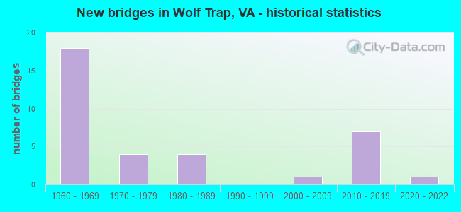
- New bridges - historical statistics
- 181960-1969
- 41970-1979
- 41980-1989
- 12000-2009
- 72010-2019
- 12020-2022

- Reconstructed bridges - Historical Statistics
- 11980-1989
- 11990-1999


- Bridge Condition - Deck
- 12.5%Very good
- 56.3%Good
- 25.0%Satisfactory
- 6.3%Fair

- Bridge Condition - Superstructure
- 5.9%Very good
- 35.3%Good
- 47.1%Satisfactory
- 11.8%Fair

- Bridge Condition - Substructure
- 5.9%Very good
- 47.1%Good
- 35.3%Satisfactory
- 11.8%Fair

- Bridge Condition - Channel
- 7.1%Very good
- 28.6%Good
- 64.3%Satisfactory

- Bridge Condition - Culverts
- 16.7%Excellent
- 66.7%Good
- 16.7%Satisfactory
Find on map >> Show street view
Structure Number: 6232, Location: 00.88 702 / 00.24 743 (Lat: 38.966108, Lng: -77.288236), Route carried "on" structure: State highway 7, Year Built: 1969, Status: Open, Structure Length: 4.57m (14.99ft), Average Daily Traffic: 55,479 (year 2020), Truck Traffic: 3%, Average Future Daily Traffic: 56,634 (year 2040), Design Load: HS 20, Features Intersected: DIFFICULT RUN, Facility Carried by Structure: LEESBURG PIKE
Minimum Vertical Clearance: 30+ m (98+ ft), Kilometerpoint: 88.962, Lanes on structure: 4, Base Highway Network: Yes, Owner: State Highway Agency, Approaching Roadway Width: 24.4m (80.1ft), Skew: 20 degrees, Material/Design: Concrete, Design/Construction: Stringer/Multi-beam, Number Of Spans In Main Unit: 4, Length of Maximum Span: 11.9m (39.0ft), Curb or Sidewalk Widths: Left: 0.2m (0.7ft), Right: 0.2m (0.7ft), Curb-To-Curb Width: 21.3m (69.9ft), Out-to-Out Width: 26.5m (86.9ft)
Condition: Deck: Satisfactory, Superstructure: Fair, Substructure: Fair, Channel: Satisfactory, Operating Rating: 57.1 metric tons, Method Used To Determine Operating Rating: Load Factor (LF), Inventory Rating: 34.1 metric tons, Method Used To Determine Inventory Rating: Load Factor (LF), Structural Evaluation: Somewhat better than minimum adequacy, Deck Geometry: Superior to present desirable criteria, Waterway Adequacy: Equal to present minimum criteria, Approach Roadway Alignment: Better than present minimum criteria, Length Of Structure Improvement: 0.30m (0.98ft), Designated Inspection Frequency: Every 24 months, Inspection Date: April 2021, Bridge Improvement Cost: $1,000, Roadway Improvement Cost: $2,000, Total Project Cost: $4,000 ( Estimate for 2015), Deck Structure Type: Concrete Cast-file-Place
Find on map >> Show street view
Structure Number: 6831, Location: 01.30FR674/00.40TO702 (Lat: 38.953306, Lng: -77.291361), Route carried "on" structure: County highway 675, Year Built: 1969, Year Reconstructed: 1997, Status: Open, Structure Length: 1.68m (5.51ft), Average Daily Traffic: 6,146 (year 2020), Truck Traffic: 1%, Average Future Daily Traffic: 8,503 (year 2040), Design Load: HS 20, Features Intersected: DIFFICULT RUN, Facility Carried by Structure: BROWN'S MILL ROAD
Minimum Vertical Clearance: 30+ m (98+ ft), Kilometerpoint: 7.997, Lanes on structure: 2, Owner: State Highway Agency, Approaching Roadway Width: 6.1m (20.0ft), Skew: 1 degrees, Material/Design: Prestressed concrete, Design/Construction: Slab, Number Of Spans In Main Unit: 2, Length of Maximum Span: 8.5m (27.9ft), Curb-To-Curb Width: 8.2m (26.9ft), Out-to-Out Width: 9.1m (29.9ft)
Condition: Deck: Good, Superstructure: Good, Substructure: Satisfactory, Channel: Satisfactory, Operating Rating: 85.9 metric tons, Method Used To Determine Operating Rating: Load and Resistance Factor (LRFR), Inventory Rating: 66.2 metric tons, Method Used To Determine Inventory Rating: Load and Resistance Factor (LRFR), Structural Evaluation: Equal to present minimum criteria, Deck Geometry: High priority of replacement, Waterway Adequacy: Somewhat better than minimum adequacy, Approach Roadway Alignment: Better than present minimum criteria, Length Of Structure Improvement: 1.77m (5.81ft), Designated Inspection Frequency: Every 24 months, Inspection Date: May 2021, Bridge Improvement Cost: $100,000, Roadway Improvement Cost: $10,000, Total Project Cost: $115,000, Deck Structure Type: Concrete Precast Panels, Wearing Surface/Protective System: Wearing Surface: Bituminous, Membrane: Epoxy, Deck Protection: Epoxy Coated Reinforcing
Find on map >> Show street view
Structure Number: 6832, Location: 00.00FR5939/00.10TO5038 (Lat: 38.942333, Lng: -77.283056), Route carried "on" structure: County highway 675, Year Built: 1963, Status: Open, Structure Length: 13.72m (45.01ft), Average Daily Traffic: 5,315 (year 2020), Truck Traffic: 1%, Average Future Daily Traffic: 5,423 (year 2040), Design Load: HS 20, Features Intersected: DAR & 267 & METRO, Facility Carried by Structure: BEULAH ROAD
Minimum Vertical Clearance: 30+ m (98+ ft), Kilometerpoint: 9.622, Lanes on structure: 2, Lanes under structure: 12, Owner: State Highway Agency, Approaching Roadway Width: 9.8m (32.2ft), Skew: 3 degrees, Material/Design: Steel, Design/Construction: Stringer/Multi-beam, Number Of Spans In Main Unit: 6, Length of Maximum Span: 25.0m (82.0ft), Curb or Sidewalk Widths: Left: 0.5m (1.6ft), Right: 0.5m (1.6ft), Curb-To-Curb Width: 7.3m (24.0ft), Out-to-Out Width: 12.1m (39.7ft)
Condition: Deck: Good, Superstructure: Satisfactory, Substructure: Good, Operating Rating: 73.5 metric tons, Method Used To Determine Operating Rating: Load and Resistance Factor (LRFR), Inventory Rating: 56.2 metric tons, Method Used To Determine Inventory Rating: Load and Resistance Factor (LRFR), Structural Evaluation: Equal to present minimum criteria, Deck Geometry: High priority of replacement, Underclear: High priority of corrective action, Approach Roadway Alignment: Somewhat better than minimum adequacy, Length Of Structure Improvement: 13.72m (45.01ft), Designated Inspection Frequency: Every 24 months, Inspection Date: May 2021, Bridge Improvement Cost: $183,000, Roadway Improvement Cost: $18,000, Total Project Cost: $250,000 ( Estimate for 2015), Deck Structure Type: Concrete Cast-file-Place, Wearing Surface/Protective System: Wearing Surface: Other
Find on map >> Show street view
Structure Number: 6834, Location: 00.70 3810 / 00.25 5020 (Lat: 38.940908, Lng: -77.267064), Route carried "on" structure: County highway 676, Year Built: 1971, Status: Open, Structure Length: 1.46m (4.79ft), Average Daily Traffic: 2,820 (year 2020), Truck Traffic: 2%, Average Future Daily Traffic: 3,948 (year 2040), Design Load: HS 20, Features Intersected: WOLFTRAP RUN, Facility Carried by Structure: TRAP ROAD
Minimum Vertical Clearance: 30+ m (98+ ft), Kilometerpoint: 4.700, Lanes on structure: 5, Owner: State Highway Agency, Approaching Roadway Width: 9.8m (32.2ft), Skew: 1 degrees, Material/Design: Concrete, Design/Construction: Culvert, Number Of Spans In Main Unit: 4, Length of Maximum Span: 3.7m (12.1ft)
Condition: Channel: Satisfactory, Culverts: Good, Operating Rating: 69.9 metric tons, Method Used To Determine Operating Rating: Load Factor (LF), Inventory Rating: 41.7 metric tons, Method Used To Determine Inventory Rating: Load Factor (LF), Structural Evaluation: Better than present minimum criteria, Waterway Adequacy: Better than present minimum criteria, Approach Roadway Alignment: Better than present minimum criteria, Length Of Structure Improvement: 0.46m (1.51ft), Designated Inspection Frequency: Every 24 months, Inspection Date: March 2021, Bridge Improvement Cost: $2,000, Roadway Improvement Cost: $2,000, Total Project Cost: $5,000 ( Estimate for 2015)
Find on map >> Show street view
Structure Number: 6836, Location: 00.40FR3810/00.50TO5020 (Lat: 38.935975, Lng: -77.267811), Route carried "on" structure: County highway 676, Year Built: 1961, Status: Open, Structure Length: 11.61m (38.09ft), Average Daily Traffic: 2,820 (year 2020), Average Future Daily Traffic: 3,948 (year 2040), Design Load: HS 20, Features Intersected: RTE. 267 & DAAR & METRO, Facility Carried by Structure: TRAP ROAD
Minimum Vertical Clearance: 30+ m (98+ ft), Kilometerpoint: 4.087, Lanes on structure: 2, Lanes under structure: 12, Owner: State Highway Agency, Approaching Roadway Width: 7.3m (24.0ft), Skew: 3 degrees, Material/Design: Steel, Design/Construction: Stringer/Multi-beam, Number Of Spans In Main Unit: 6, Length of Maximum Span: 21.6m (70.9ft), Curb or Sidewalk Widths: Left: 0.5m (1.6ft), Right: 0.5m (1.6ft), Curb-To-Curb Width: 7.3m (24.0ft), Out-to-Out Width: 8.8m (28.9ft)
Condition: Deck: Fair, Superstructure: Satisfactory, Substructure: Satisfactory, Operating Rating: 93.4 metric tons, Method Used To Determine Operating Rating: Load and Resistance Factor (LRFR), Inventory Rating: 71.7 metric tons, Method Used To Determine Inventory Rating: Load and Resistance Factor (LRFR), Structural Evaluation: Equal to present minimum criteria, Deck Geometry: High priority of replacement, Underclear: High priority of corrective action, Approach Roadway Alignment: Better than present minimum criteria, Length Of Structure Improvement: 11.61m (38.09ft), Designated Inspection Frequency: Every 24 months, Inspection Date: June 2020, Bridge Improvement Cost: $183,000, Roadway Improvement Cost: $18,000, Total Project Cost: $220,000 ( Estimate for 2014), Deck Structure Type: Concrete Cast-file-Place
Find on map >> Show street view
Structure Number: 6838, Location: 00.50FR3810/00.45TO5020 (Lat: 38.938875, Lng: -77.267167), Route carried "on" structure: County highway 676, Year Built: 1973, Status: Open, Structure Length: 0.67m (2.20ft), Average Daily Traffic: 2,820 (year 2020), Truck Traffic: 2%, Average Future Daily Traffic: 3,948 (year 2040), Design Load: HS 20, Features Intersected: PEDESTRIAN UNDERPASS, Facility Carried by Structure: TRAP ROAD
Minimum Vertical Clearance: 30+ m (98+ ft), Kilometerpoint: 4.386, Lanes on structure: 5, Owner: State Highway Agency, Approaching Roadway Width: 8.5m (27.9ft), Skew: 2 degrees, Material/Design: Concrete, Design/Construction: Culvert, Number Of Spans In Main Unit: 1, Length of Maximum Span: 6.7m (22.0ft)
Condition: Culverts: Good, Operating Rating: 76.2 metric tons, Method Used To Determine Operating Rating: Load Factor (LF), Inventory Rating: 45.4 metric tons, Method Used To Determine Inventory Rating: Load Factor (LF), Structural Evaluation: Better than present minimum criteria, Approach Roadway Alignment: Equal to present minimum criteria, Length Of Structure Improvement: 5.58m (18.31ft), Designated Inspection Frequency: Every 24 months, Inspection Date: May 2021, Bridge Improvement Cost: $33,000, Roadway Improvement Cost: $66,000, Total Project Cost: $100,000 ( Estimate for 2015)
Find on map >> Show street view
Structure Number: 6839, Location: 00.20FR674/00.45TO6758 (Lat: 38.932450, Lng: -77.308225), Route carried "on" structure: County highway 677, Year Built: 2013, Status: Open, Structure Length: 0.91m (2.99ft), Average Daily Traffic: 500 (year 2020), Truck Traffic: 1%, Average Future Daily Traffic: 542 (year 2040), Design Load: HS 20, Features Intersected: SNAKEDEN BRANCH, Facility Carried by Structure: HUNTER STATION RD.
Minimum Vertical Clearance: 30+ m (98+ ft), Kilometerpoint: 1.593, Lanes on structure: 1, Owner: State Highway Agency, Approaching Roadway Width: 5.5m (18.0ft), Material/Design: Steel, Design/Construction: Girder and Floorbeam System, Number Of Spans In Main Unit: 1, Length of Maximum Span: 8.2m (26.9ft), Curb-To-Curb Width: 4.9m (16.1ft), Out-to-Out Width: 4.9m (16.1ft)
Condition: Deck: Very good, Superstructure: Good, Substructure: Very good, Channel: Satisfactory, Operating Rating: 61.7 metric tons, Method Used To Determine Operating Rating: Load and Resistance Factor (LRFR), Inventory Rating: 47.2 metric tons, Method Used To Determine Inventory Rating: Load and Resistance Factor (LRFR), Structural Evaluation: Better than present minimum criteria, Deck Geometry: High priority of replacement, Waterway Adequacy: Somewhat better than minimum adequacy, Approach Roadway Alignment: Somewhat better than minimum adequacy, Length Of Structure Improvement: 0.30m (0.98ft), Designated Inspection Frequency: Every 24 months, Critical Feature Inspection Frequency: Every 24 months, Inspection Date: September 2021, Critical Feature Inspection Date: September 2021, Bridge Improvement Cost: $100,000, Roadway Improvement Cost: $100,000, Total Project Cost: $250,000, Deck Structure Type: Steel plate, Wearing Surface/Protective System: Wearing Surface: Other, Membrane: Other
Find on map >> Show street view
Structure Number: 687, Location: 0.00FR675/00.30TO678 (Lat: 38.950706, Lng: -77.284489), Route carried "on" structure: County highway 702, Year Built: 1965, Year Reconstructed: 1994, Status: Open, Structure Length: 0.94m (3.08ft), Average Daily Traffic: 5,407 (year 2020), Truck Traffic: 1%, Average Future Daily Traffic: 7,183 (year 2040), Design Load: HS 20, Features Intersected: WOLF TRAP RUN, Facility Carried by Structure: BEULAH ROAD
Minimum Vertical Clearance: 30+ m (98+ ft), Kilometerpoint: 0.048, Lanes on structure: 2, Owner: State Highway Agency, Approaching Roadway Width: 6.4m (21.0ft), Material/Design: Concrete, Design/Construction: Slab, Number Of Spans In Main Unit: 1, Length of Maximum Span: 9.1m (29.9ft), Curb-To-Curb Width: 6.8m (22.3ft), Out-to-Out Width: 7.2m (23.6ft)
Condition: Deck: Good, Superstructure: Good, Substructure: Good, Channel: Good, Operating Rating: 54.4 metric tons, Method Used To Determine Operating Rating: Load and Resistance Factor (LRFR), Inventory Rating: 40.8 metric tons, Method Used To Determine Inventory Rating: Load and Resistance Factor (LRFR), Structural Evaluation: Better than present minimum criteria, Deck Geometry: High priority of replacement, Waterway Adequacy: Somewhat better than minimum adequacy, Approach Roadway Alignment: Equal to present minimum criteria, Length Of Structure Improvement: 1.83m (6.00ft), Designated Inspection Frequency: Every 24 months, Inspection Date: December 2020, Bridge Improvement Cost: $220,000, Roadway Improvement Cost: $35,000, Total Project Cost: $260,000, Deck Structure Type: Concrete Precast Panels, Wearing Surface/Protective System: Wearing Surface: Bituminous, Membrane: Epoxy, Deck Protection: Epoxy Coated Reinforcing
Find on map >> Show street view
Structure Number: 6974, Location: 00.15FR.3810/00.08TO6038 (Lat: 38.931994, Lng: -77.263078), Route carried "on" structure: County highway 3203, Year Built: 1977, Status: Open, Structure Length: 1.28m (4.20ft), Average Daily Traffic: 587 (year 2002), Average Future Daily Traffic: 699 (year 2040), Design Load: HS 20+Mod, Features Intersected: WOLFTRAP CREEK, Facility Carried by Structure: BOIS AVENUE
Minimum Vertical Clearance: 30+ m (98+ ft), Kilometerpoint: 0.230, Lanes on structure: 2, Owner: State Highway Agency, Approaching Roadway Width: 9.1m (29.9ft), Material/Design: Concrete, Design/Construction: Culvert, Number Of Spans In Main Unit: 4, Length of Maximum Span: 3.0m (9.8ft)
Condition: Channel: Satisfactory, Culverts: Good, Operating Rating: 73.5 metric tons, Method Used To Determine Operating Rating: Load Factor (LF), Inventory Rating: 43.5 metric tons, Method Used To Determine Inventory Rating: Load Factor (LF), Structural Evaluation: Better than present minimum criteria, Waterway Adequacy: Better than present minimum criteria, Approach Roadway Alignment: Better than present minimum criteria, Length Of Structure Improvement: 5.12m (16.80ft), Designated Inspection Frequency: Every 24 months, Inspection Date: April 2021, Bridge Improvement Cost: $55,000, Roadway Improvement Cost: $79,000, Total Project Cost: $150,000 ( Estimate for 2017)
Find on map >> Show street view
Structure Number: 7063, Location: 00.14FR.5757/00.30TO7 (Lat: 38.938136, Lng: -77.257014), Route carried "on" structure: County highway 5764, Year Built: 1973, Status: Open, Structure Length: 1.22m (4.00ft), Average Daily Traffic: 504 (year 2016), Average Future Daily Traffic: 564 (year 2040), Design Load: HS 20, Features Intersected: OLD COURTHOUSE SPRING BR, Facility Carried by Structure: LAUREL HILL DRIVE
Minimum Vertical Clearance: 30+ m (98+ ft), Kilometerpoint: 0.632, Lanes on structure: 2, Owner: State Highway Agency, Approaching Roadway Width: 13.4m (44.0ft), Skew: 1 degrees, Material/Design: Concrete, Design/Construction: Culvert, Number Of Spans In Main Unit: 3, Length of Maximum Span: 2.7m (8.9ft)
Condition: Channel: Satisfactory, Culverts: Satisfactory, Operating Rating: 44.5 metric tons, Method Used To Determine Operating Rating: Load Factor (LF), Inventory Rating: 32.7 metric tons, Method Used To Determine Inventory Rating: Load Factor (LF), Structural Evaluation: Equal to present minimum criteria, Waterway Adequacy: Better than present minimum criteria, Approach Roadway Alignment: Better than present minimum criteria, Length Of Structure Improvement: 5.49m (18.01ft), Designated Inspection Frequency: Every 24 months, Inspection Date: April 2021, Bridge Improvement Cost: $44,000, Roadway Improvement Cost: $65,000, Total Project Cost: $150,000
Find on map >> Show street view
Structure Number: 26941, Location: 00.30FR7/00.07TOWILLINGHA (Lat: 38.935542, Lng: -77.253711), Route carried "on" structure: County highway 8912, Year Built: 2000, Status: Open, Structure Length: 0.98m (3.22ft), Average Daily Traffic: 500 (year 2001), Truck Traffic: 1%, Average Future Daily Traffic: 1,500 (year 2031), Design Load: HS 20, Features Intersected: COURTHOUSE SPRING BRANCH, Facility Carried by Structure: JARRETT VALLEY DR.
Minimum Vertical Clearance: 30+ m (98+ ft), Kilometerpoint: 0.000, Lanes on structure: 2, Owner: State Highway Agency, Approaching Roadway Width: 9.8m (32.2ft), Material/Design: Concrete, Design/Construction: Culvert, Number Of Spans In Main Unit: 3, Length of Maximum Span: 3.0m (9.8ft), Curb-To-Curb Width: 11.0m (36.1ft), Out-to-Out Width: 12.2m (40.0ft)
Condition: Channel: Good, Culverts: Good, Operating Rating: 89.8 metric tons, Method Used To Determine Operating Rating: Load Factor (LF), Inventory Rating: 77.1 metric tons, Method Used To Determine Inventory Rating: Load Factor (LF), Structural Evaluation: Better than present minimum criteria, Deck Geometry: Better than present minimum criteria, Waterway Adequacy: Equal to present desirable criteria, Approach Roadway Alignment: Equal to present desirable criteria, Length Of Structure Improvement: 7.86m (25.79ft), Designated Inspection Frequency: Every 24 months, Inspection Date: January 2021, Bridge Improvement Cost: $32,000, Roadway Improvement Cost: $67,000, Total Project Cost: $110,000
Find on map >> Show street view
Structure Number: 29839, Location: 00.20FR0677/00.70TO673 (Lat: 38.929819, Lng: -77.305111), Route carried "on" structure: County highway 674, Year Built: 2011, Status: Open, Structure Length: 1.59m (5.22ft), Average Daily Traffic: 12,166 (year 2020), Truck Traffic: 1%, Average Future Daily Traffic: 14,216 (year 2040), Design Load: HS 20, Features Intersected: DIFFICULT RUN, Facility Carried by Structure: HUNTER MILL ROAD
Minimum Vertical Clearance: 30+ m (98+ ft), Kilometerpoint: 0.000, Lanes on structure: 2, Owner: State Highway Agency, Approaching Roadway Width: 7.3m (24.0ft), Material/Design: Steel, Design/Construction: Truss - Thru, Number Of Spans In Main Unit: 1, Length of Maximum Span: 15.2m (49.9ft), Curb or Sidewalk Widths: Left: 0.3m (1.0ft), Right: 0.5m (1.6ft), Curb-To-Curb Width: 6.7m (22.0ft), Out-to-Out Width: 7.9m (25.9ft)
Condition: Deck: Good, Superstructure: Good, Substructure: Good, Channel: Satisfactory, Operating Rating: 46.1 metric tons, Method Used To Determine Operating Rating: Load and Resistance Factor (LRFR), Inventory Rating: 35.6 metric tons, Method Used To Determine Inventory Rating: Load and Resistance Factor (LRFR), Structural Evaluation: Better than present minimum criteria, Deck Geometry: High priority of replacement, Waterway Adequacy: Somewhat better than minimum adequacy, Approach Roadway Alignment: Better than present minimum criteria, Length Of Structure Improvement: 0.30m (0.98ft), Designated Inspection Frequency: Every 12 months, Critical Feature Inspection Frequency: Every 12 months, Inspection Date: November 2021, Critical Feature Inspection Date: November 2021, Bridge Improvement Cost: $1,000, Roadway Improvement Cost: $1,000, Total Project Cost: $3,000 ( Estimate for 2014), Deck Structure Type: Steel plate, Wearing Surface/Protective System: Wearing Surface: Other, Deck Protection: Other
Find on map >> Show street view
Structure Number: 30372, Location: 00.72fr694 & 01.25to123 (Lat: 38.934619, Lng: -77.247294), Route carried "on" structure: State highway 7, Year Built: 2016, Status: Open, Structure Length: 13.32m (43.70ft), Average Daily Traffic: 55,479 (year 2020), Truck Traffic: 3%, Average Future Daily Traffic: 56,634 (year 2040), Design Load: HL 93, Features Intersected: DTR & DAR, Facility Carried by Structure: LEESBURG PIKE
Minimum Vertical Clearance: 30.18m (99.02ft), Kilometerpoint: 0.000, Lanes on structure: 9, Lanes under structure: 14, Base Highway Network: Yes, Owner: State Highway Agency, Approaching Roadway Width: 34.7m (113.8ft), Skew: 21 degrees, Material/Design: Steel continuous, Design/Construction: Stringer/Multi-beam, Number Of Spans In Main Unit: 6, Length of Maximum Span: 24.4m (80.1ft), Curb or Sidewalk Widths: Left: 4.3m (14.1ft), Right: 4.3m (14.1ft), Curb-To-Curb Width: 34.7m (113.8ft), Out-to-Out Width: 45.4m (149.0ft)
Condition: Deck: Very good, Superstructure: Very good, Substructure: Good, Operating Rating: 68.5 metric tons, Method Used To Determine Operating Rating: Load and Resistance Factor (LRFR), Inventory Rating: 52.8 metric tons, Method Used To Determine Inventory Rating: Load and Resistance Factor (LRFR), Structural Evaluation: Better than present minimum criteria, Deck Geometry: Somewhat better than minimum adequacy, Underclear: Somewhat better than minimum adequacy, Approach Roadway Alignment: Equal to present minimum criteria, Designated Inspection Frequency: Every 24 months, Inspection Date: April 2020, Deck Structure Type: Concrete Cast-file-Place, Wearing Surface/Protective System: Wearing Surface: Monolithic Concrete, Deck Protection: Other
Find on map >> Show street view
Structure Number: 30891, Location: 00.02FR7/00.04TO6708 (Lat: 38.967083, Lng: -77.291603), Route carried "on" structure: County highway 743, Year Built: 2021, Status: Open, Structure Length: 0.96m (3.15ft), Average Daily Traffic: 1,156 (year 2002), Average Future Daily Traffic: 1,376 (year 2040), Design Load: HL 93, Features Intersected: COLVIN RUN, Facility Carried by Structure: CARPERS FARM WAY
Minimum Vertical Clearance: 30.18m (99.02ft), Kilometerpoint: 0.000, Lanes on structure: 2, Owner: State Highway Agency, Approaching Roadway Width: 7.3m (24.0ft), Material/Design: Concrete, Design/Construction: Culvert, Number Of Spans In Main Unit: 3, Length of Maximum Span: 3.0m (9.8ft)
Condition: Channel: Very good, Culverts: Excellent, Operating Rating: 89.9 metric tons, Method Used To Determine Operating Rating: Load and Resistance Factor (LRFR), Inventory Rating: 89.8 metric tons, Method Used To Determine Inventory Rating: Load and Resistance Factor (LRFR), Structural Evaluation: Superior to present desirable criteria, Waterway Adequacy: Better than present minimum criteria, Approach Roadway Alignment: Equal to present minimum criteria, Length Of Structure Improvement: 0.30m (0.98ft), Designated Inspection Frequency: Every 24 months, Inspection Date: March 2021, Bridge Improvement Cost: $1,000, Roadway Improvement Cost: $1,000, Total Project Cost: $3,000
Find on map >> Show street view
Structure Number: 2100013P, Location: 8.7 MILES FROM DULLES AIR (Lat: 38.945861, Lng: -77.293222), Route carried "on" structure: Other road 267, Year Built: 1963, Status: Open, Structure Length: 6.23m (20.44ft), Average Daily Traffic: 13,000 (year 2006), Truck Traffic: 12%, Average Future Daily Traffic: 14,300 (year 2026), Design Load: HS 20, Features Intersected: DIFFICULT RUN, Facility Carried by Structure: WB DULLES ACCESS R
Minimum Vertical Clearance: 30+ m (98+ ft), Kilometerpoint: 14.000, Lanes on structure: 2, Toll: On toll road, Owner: Metropolitan Washington Airports Service, Approaching Roadway Width: 11.0m (36.1ft), Skew: 2 degrees, Material/Design: Steel, Design/Construction: Stringer/Multi-beam, Number Of Spans In Main Unit: 3, Length of Maximum Span: 24.0m (78.7ft), Curb-To-Curb Width: 11.7m (38.4ft), Out-to-Out Width: 13.4m (44.0ft)
Condition: Deck: Good, Superstructure: Satisfactory, Substructure: Satisfactory, Channel: Satisfactory, Operating Rating: 54.4 metric tons, Method Used To Determine Operating Rating: Allowable Stress (AS), Inventory Rating: 33.0 metric tons, Method Used To Determine Inventory Rating: Allowable Stress (AS), Structural Evaluation: Equal to present minimum criteria, Deck Geometry: Better than present minimum criteria, Waterway Adequacy: Equal to present desirable criteria, Approach Roadway Alignment: Equal to present desirable criteria, Designated Inspection Frequency: Every 24 months, Inspection Date: September 2019, Bridge Improvement Cost: $40,000, Roadway Improvement Cost: $4,000, Total Project Cost: $60,000 ( Estimate for 2017), Deck Structure Type: Concrete Cast-file-Place, Wearing Surface/Protective System: Wearing Surface: Other
Find on map >> Show street view
Structure Number: 2100014P, Location: 8.7 MILES FROM DULLES AIR (Lat: 38.945722, Lng: -77.293278), Route carried "on" structure: Other road 267, Year Built: 1963, Status: Open, Structure Length: 6.23m (20.44ft), Average Daily Traffic: 13,000 (year 2006), Truck Traffic: 12%, Average Future Daily Traffic: 14,300 (year 2026), Design Load: HS 20, Features Intersected: DIFFICULT RUN, Facility Carried by Structure: EB DULLES ACCESS R
Minimum Vertical Clearance: 30+ m (98+ ft), Kilometerpoint: 14.000, Lanes on structure: 2, Toll: On toll road, Owner: Metropolitan Washington Airports Service, Approaching Roadway Width: 11.0m (36.1ft), Skew: 2 degrees, Material/Design: Steel, Design/Construction: Stringer/Multi-beam, Number Of Spans In Main Unit: 3, Length of Maximum Span: 24.0m (78.7ft), Curb-To-Curb Width: 11.6m (38.1ft), Out-to-Out Width: 13.2m (43.3ft)
Condition: Deck: Satisfactory, Superstructure: Satisfactory, Substructure: Satisfactory, Channel: Satisfactory, Operating Rating: 54.4 metric tons, Method Used To Determine Operating Rating: Allowable Stress (AS), Inventory Rating: 33.0 metric tons, Method Used To Determine Inventory Rating: Allowable Stress (AS), Structural Evaluation: Equal to present minimum criteria, Deck Geometry: Better than present minimum criteria, Waterway Adequacy: Equal to present desirable criteria, Approach Roadway Alignment: Equal to present desirable criteria, Designated Inspection Frequency: Every 24 months, Inspection Date: September 2019, Bridge Improvement Cost: $40,000, Roadway Improvement Cost: $4,000, Total Project Cost: $60,000 ( Estimate for 2017), Deck Structure Type: Concrete Cast-file-Place, Wearing Surface/Protective System: Wearing Surface: Other
Find on map >> Show street view
Structure Number: 2100035P, Location: 8.0 MILES FROM DULLES AIR (Lat: 38.947933, Lng: -77.311950), Route carried "on" structure: Other road 267, Year Built: 1961, Status: Open, Structure Length: 3.72m (12.20ft), Average Daily Traffic: 22,000 (year 2008), Average Future Daily Traffic: 26,400 (year 2028), Features Intersected: HUNTER MILL ROAD, Facility Carried by Structure: WB DULLES ACCESS R
Minimum Vertical Clearance: 30+ m (98+ ft), Kilometerpoint: 12.870, Lanes on structure: 2, Lanes under structure: 2, Toll: On toll road, Owner: Metropolitan Washington Airports Service, Approaching Roadway Width: 11.8m (38.7ft), Skew: 2 degrees, Material/Design: Steel, Design/Construction: Stringer/Multi-beam, Number Of Spans In Main Unit: 3, Length of Maximum Span: 17.5m (57.4ft), Curb-To-Curb Width: 11.9m (39.0ft), Out-to-Out Width: 13.5m (44.3ft)
Condition: Deck: Good, Superstructure: Fair, Substructure: Fair, Operating Rating: 54.5 metric tons, Method Used To Determine Operating Rating: Field evaluation and documented engineering judgment, Inventory Rating: 32.7 metric tons, Method Used To Determine Inventory Rating: Field evaluation and documented engineering judgment, Structural Evaluation: Somewhat better than minimum adequacy, Deck Geometry: Better than present minimum criteria, Underclear: High priority of corrective action, Approach Roadway Alignment: Equal to present desirable criteria, Designated Inspection Frequency: Every 24 months, Inspection Date: October 2019, Bridge Improvement Cost: $40,000, Roadway Improvement Cost: $4,000, Total Project Cost: $60,000 ( Estimate for 2017), Deck Structure Type: Concrete Cast-file-Place, Wearing Surface/Protective System: Wearing Surface: Monolithic Concrete
Find on map >> Show street view
Structure Number: 2100039P, Location: 8.0 MILES FROM DULLES AIR (Lat: 38.947675, Lng: -77.311983), Route carried "on" structure: Other road 367, Year Built: 1963, Status: Open, Structure Length: 3.69m (12.11ft), Average Daily Traffic: 22,000 (year 2008), Average Future Daily Traffic: 26,400 (year 2028), Features Intersected: HUNTER MILL ROAD, Facility Carried by Structure: EB DULLES ACCESS R
Minimum Vertical Clearance: 30+ m (98+ ft), Kilometerpoint: 12.870, Lanes on structure: 2, Lanes under structure: 3, Toll: On toll road, Owner: Metropolitan Washington Airports Service, Approaching Roadway Width: 11.6m (38.1ft), Skew: 2 degrees, Material/Design: Steel, Design/Construction: Stringer/Multi-beam, Number Of Spans In Main Unit: 3, Length of Maximum Span: 17.5m (57.4ft), Curb-To-Curb Width: 11.7m (38.4ft), Out-to-Out Width: 13.3m (43.6ft)
Condition: Deck: Satisfactory, Superstructure: Satisfactory, Substructure: Good, Operating Rating: 54.5 metric tons, Method Used To Determine Operating Rating: Field evaluation and documented engineering judgment, Inventory Rating: 32.7 metric tons, Method Used To Determine Inventory Rating: Field evaluation and documented engineering judgment, Structural Evaluation: Equal to present minimum criteria, Deck Geometry: Somewhat better than minimum adequacy, Underclear: High priority of corrective action, Approach Roadway Alignment: Equal to present desirable criteria, Designated Inspection Frequency: Every 24 months, Inspection Date: October 2019, Bridge Improvement Cost: $125,000, Roadway Improvement Cost: $13,000, Total Project Cost: $188,000 ( Estimate for 2017), Deck Structure Type: Concrete Cast-file-Place, Wearing Surface/Protective System: Wearing Surface: Monolithic Concrete
Find on map >> Show street view
Structure Number: 2100044P, Location: 8.7 MILES FROM DULLES AIR (Lat: 38.945300, Lng: -77.293267), Route carried "on" structure: State highway 367, Year Built: 1984, Status: Open, Structure Length: 6.22m (20.41ft), Average Daily Traffic: 22,000 (year 2008), Average Future Daily Traffic: 26,400 (year 2028), Features Intersected: DIFFICULT RUN, Facility Carried by Structure: EB DULLES TOLL ROA
Minimum Vertical Clearance: 30+ m (98+ ft), Kilometerpoint: 14.480, Lanes on structure: 3, Toll: On toll road, Owner: Metropolitan Washington Airports Service, Approaching Roadway Width: 18.2m (59.7ft), Skew: 2 degrees, Material/Design: Steel, Design/Construction: Stringer/Multi-beam, Number Of Spans In Main Unit: 3, Length of Maximum Span: 24.1m (79.1ft), Curb-To-Curb Width: 18.3m (60.0ft), Out-to-Out Width: 19.2m (63.0ft)
Condition: Deck: Good, Superstructure: Satisfactory, Substructure: Satisfactory, Channel: Good, Inventory Rating: 54.4 metric tons, Method Used To Determine Inventory Rating: Field evaluation and documented engineering judgment, Structural Evaluation: Equal to present minimum criteria, Deck Geometry: Superior to present desirable criteria, Waterway Adequacy: Equal to present desirable criteria, Approach Roadway Alignment: Equal to present desirable criteria, Designated Inspection Frequency: Every 24 months, Inspection Date: September 2019, Deck Structure Type: Concrete Cast-file-Place, Wearing Surface/Protective System: Wearing Surface: Monolithic Concrete, Deck Protection: Epoxy Coated Reinforcing
Find on map >> Show street view
Structure Number: 2100045P, Location: 8.7 MILES FROM DULLES AIR (Lat: 38.946003, Lng: -77.292961), Route carried "on" structure: State highway 367, Year Built: 1984, Status: Open, Structure Length: 6.19m (20.31ft), Average Daily Traffic: 22,000 (year 2008), Average Future Daily Traffic: 26,400 (year 2028), Features Intersected: DIFFICULT RUN, Facility Carried by Structure: WB DULLES TOLL ROA
Minimum Vertical Clearance: 30+ m (98+ ft), Kilometerpoint: 14.480, Lanes on structure: 4, Toll: On toll road, Owner: Metropolitan Washington Airports Service, Approaching Roadway Width: 19.5m (64.0ft), Skew: 2 degrees, Material/Design: Steel, Design/Construction: Stringer/Multi-beam, Number Of Spans In Main Unit: 3, Length of Maximum Span: 24.1m (79.1ft), Curb-To-Curb Width: 20.4m (66.9ft), Out-to-Out Width: 20.8m (68.2ft)
Condition: Deck: Satisfactory, Superstructure: Satisfactory, Substructure: Satisfactory, Channel: Good, Inventory Rating: 55.3 metric tons, Method Used To Determine Inventory Rating: Field evaluation and documented engineering judgment, Structural Evaluation: Equal to present minimum criteria, Deck Geometry: Superior to present desirable criteria, Waterway Adequacy: Equal to present desirable criteria, Approach Roadway Alignment: Equal to present desirable criteria, Designated Inspection Frequency: Every 24 months, Inspection Date: September 2019, Deck Structure Type: Concrete Cast-file-Place, Wearing Surface/Protective System: Wearing Surface: Latex Concrete, Deck Protection: Epoxy Coated Reinforcing
Find on map >> Show street view
Structure Number: 2100048P, Location: 8.0 MILES FROM DULLES AIR (Lat: 38.948153, Lng: -77.311956), Route carried "on" structure: State highway 367, Year Built: 1984, Status: Open, Structure Length: 3.02m (9.91ft), Average Daily Traffic: 22,000 (year 2008), Average Future Daily Traffic: 26,400 (year 2028), Features Intersected: HUNTER MILL ROAD, Facility Carried by Structure: WB DULLES TOLL ROA
Minimum Vertical Clearance: 30+ m (98+ ft), Kilometerpoint: 12.870, Lanes on structure: 4, Lanes under structure: 3, Toll: On toll road, Owner: Metropolitan Washington Airports Service, Approaching Roadway Width: 17.7m (58.1ft), Skew: 1 degrees, Material/Design: Steel, Design/Construction: Stringer/Multi-beam, Number Of Spans In Main Unit: 1, Length of Maximum Span: 30.2m (99.1ft), Curb-To-Curb Width: 9.6m (31.5ft), Out-to-Out Width: 17.7m (58.1ft)
Condition: Deck: Good, Superstructure: Good, Substructure: Good, Operating Rating: 54.5 metric tons, Method Used To Determine Operating Rating: Field evaluation and documented engineering judgment, Inventory Rating: 32.7 metric tons, Method Used To Determine Inventory Rating: Field evaluation and documented engineering judgment, Structural Evaluation: Better than present minimum criteria, Deck Geometry: High priority of replacement, Underclear: High priority of corrective action, Approach Roadway Alignment: Equal to present desirable criteria, Designated Inspection Frequency: Every 24 months, Inspection Date: October 2019, Deck Structure Type: Concrete Cast-file-Place, Wearing Surface/Protective System: Wearing Surface: Latex Concrete, Deck Protection: Epoxy Coated Reinforcing
Find on map >> Show street view
Structure Number: 2100049P, Location: 8.0 MILES FROM DULLES AIR (Lat: 38.947458, Lng: -77.311986), Route carried "on" structure: State highway 367, Year Built: 1984, Status: Open, Structure Length: 3.03m (9.94ft), Average Daily Traffic: 22,000 (year 2008), Average Future Daily Traffic: 26,400 (year 2028), Features Intersected: HUNTER MILL ROAD, Facility Carried by Structure: EB DULLES TOLL ROA
Minimum Vertical Clearance: 30+ m (98+ ft), Kilometerpoint: 12.870, Lanes on structure: 4, Lanes under structure: 3, Toll: On toll road, Owner: Metropolitan Washington Airports Service, Approaching Roadway Width: 17.7m (58.1ft), Skew: 1 degrees, Material/Design: Steel, Design/Construction: Stringer/Multi-beam, Number Of Spans In Main Unit: 1, Length of Maximum Span: 30.3m (99.4ft), Curb-To-Curb Width: 17.7m (58.1ft), Out-to-Out Width: 18.7m (61.4ft)
Condition: Deck: Good, Superstructure: Satisfactory, Substructure: Good, Operating Rating: 54.5 metric tons, Method Used To Determine Operating Rating: Field evaluation and documented engineering judgment, Inventory Rating: 32.7 metric tons, Method Used To Determine Inventory Rating: Field evaluation and documented engineering judgment, Structural Evaluation: Equal to present minimum criteria, Deck Geometry: Somewhat better than minimum adequacy, Underclear: High priority of corrective action, Approach Roadway Alignment: Equal to present desirable criteria, Designated Inspection Frequency: Every 24 months, Inspection Date: October 2019, Deck Structure Type: Concrete Cast-file-Place, Wearing Surface/Protective System: Wearing Surface: Latex Concrete, Deck Protection: Epoxy Coated Reinforcing
Find on map >> Show street view
Structure Number: 3800001P, Location: 1 MILE SOUTH OF ROUTE 7 (Lat: 38.938944, Lng: -77.267361), Route carried "on" structure: Federal lands road , Year Built: 1966, Status: Open, Structure Length: 0.61m (2.00ft), Average Daily Traffic: 1 (year 2008), Average Future Daily Traffic: 2 (year 2028), Design Load: HS 20, Features Intersected: SERVICE UNDERPASS, Facility Carried by Structure: TRAP ROAD
Minimum Vertical Clearance: 30+ m (98+ ft), Kilometerpoint: 0.000, Lanes on structure: 5, Lanes under structure: 2, Owner: National Park Service, Approaching Roadway Width: 7.6m (24.9ft), Skew: 10 degrees, Material/Design: Concrete, Design/Construction: Frame, Number Of Spans In Main Unit: 1, Length of Maximum Span: 6.1m (20.0ft), Curb-To-Curb Width: 18.0m (59.1ft), Out-to-Out Width: 55.5m (182.1ft)
Condition: Superstructure: Good, Substructure: Good, Operating Rating: 54.4 metric tons, Method Used To Determine Operating Rating: Field evaluation and documented engineering judgment, Inventory Rating: 32.7 metric tons, Method Used To Determine Inventory Rating: Field evaluation and documented engineering judgment, Structural Evaluation: Better than present minimum criteria, Deck Geometry: High priority of replacement, Underclear: High priority of corrective action, Approach Roadway Alignment: Equal to present desirable criteria, Designated Inspection Frequency: Every 24 months, Inspection Date: November 2020
Find on map >> Show street view
Structure Number: 6832, Location: 00.00FR5939/00.10TO5038 (Lat: 38.942333, Lng: -77.283056), Route carried "under" structure: Other road , Year Built: 1963, Structure Length: 0. m, Average Daily Traffic: 25,000 (year 2003), Features Intersected: DAR & 267 & METRO, Facility Carried by Structure: BEULAH ROAD
Minimum Vertical Clearance: 4.55m (14.93ft), Kilometerpoint: 0.000, Lanes on structure: 2, Lanes under structure: 2, Toll: On toll road, Material/Design: Steel, Design/Construction: Stringer/Multi-beam, Length of Maximum Span: 25.0m (82.0ft)
Find on map >> Show street view
Structure Number: 6832, Location: 00.00FR5939/00.10TO5038 (Lat: 38.942333, Lng: -77.283056), Route carried "under" structure: Other road 267, Year Built: 1963, Structure Length: 0. m, Average Daily Traffic: 65,000 (year 2003), Features Intersected: DAR & 267 & METRO, Facility Carried by Structure: BEULAH ROAD
Minimum Vertical Clearance: 5.11m (16.77ft), Kilometerpoint: 0.000, Lanes on structure: 2, Lanes under structure: 4, Toll: On toll road, Material/Design: Steel, Design/Construction: Stringer/Multi-beam, Length of Maximum Span: 25.0m (82.0ft)
Find on map >> Show street view
Structure Number: 6832, Location: 00.00FR5939/00.10TO5038 (Lat: 38.942333, Lng: -77.283056), Route carried "under" structure: Other road 267, Year Built: 1963, Structure Length: 0. m, Average Daily Traffic: 63,781 (year 1994), Features Intersected: DAR & 267 & METRO, Facility Carried by Structure: BEULAH ROAD
Minimum Vertical Clearance: 5.16m (16.93ft), Kilometerpoint: 11.263, Lanes on structure: 2, Lanes under structure: 4, Toll: On toll road, Material/Design: Steel, Design/Construction: Stringer/Multi-beam, Length of Maximum Span: 25.0m (82.0ft)
Find on map >> Show street view
Structure Number: 6836, Location: 00.40FR3810/00.50TO5020 (Lat: 38.935975, Lng: -77.267811), Route carried "under" structure: State highway 267, Year Built: 1961, Structure Length: 0. m, Average Daily Traffic: 55,000 (year 1994), Features Intersected: RTE. 267 & DAAR & METRO, Facility Carried by Structure: TRAP ROAD
Minimum Vertical Clearance: 6.22m (20.41ft), Kilometerpoint: 0.000, Lanes on structure: 2, Lanes under structure: 4, Toll: On toll road, Material/Design: Steel, Design/Construction: Stringer/Multi-beam, Length of Maximum Span: 21.6m (70.9ft)
Find on map >> Show street view
Structure Number: 6836, Location: 00.40FR3810/00.50TO5020 (Lat: 38.935975, Lng: -77.267811), Route carried "under" structure: State highway 267, Year Built: 1961, Structure Length: 0. m, Average Daily Traffic: 55,000 (year 1994), Features Intersected: RTE. 267 & DAAR & METRO, Facility Carried by Structure: TRAP ROAD
Minimum Vertical Clearance: 5.64m (18.50ft), Kilometerpoint: 9.654, Lanes on structure: 2, Lanes under structure: 4, Toll: On toll road, Material/Design: Steel, Design/Construction: Stringer/Multi-beam, Length of Maximum Span: 21.6m (70.9ft)
Find on map >> Show street view
Structure Number: 6836, Location: 00.40FR3810/00.50TO5020 (Lat: 38.935975, Lng: -77.267811), Route carried "under" structure: Other road , Year Built: 1961, Structure Length: 0. m, Average Daily Traffic: 15,000 (year 1994), Features Intersected: RTE. 267 & DAAR & METRO, Facility Carried by Structure: TRAP ROAD
Minimum Vertical Clearance: 4.50m (14.76ft), Kilometerpoint: 0.000, Lanes on structure: 2, Lanes under structure: 2, Material/Design: Steel, Design/Construction: Stringer/Multi-beam, Length of Maximum Span: 21.6m (70.9ft)
Find on map >> Show street view
Structure Number: 6836, Location: 00.40FR3810/00.50TO5020 (Lat: 38.935975, Lng: -77.267811), Route carried "under" structure: Other road , Year Built: 1961, Structure Length: 0. m, Average Daily Traffic: 15,000 (year 1994), Features Intersected: RTE. 267 & DAAR & METRO, Facility Carried by Structure: TRAP ROAD
Minimum Vertical Clearance: 4.67m (15.32ft), Kilometerpoint: 0.000, Lanes on structure: 2, Lanes under structure: 2, Material/Design: Steel, Design/Construction: Stringer/Multi-beam, Length of Maximum Span: 21.6m (70.9ft)
Find on map >> Show street view
Structure Number: 30372, Location: 00.72fr694 & 01.25to123 (Lat: 38.934619, Lng: -77.247294), Route carried "under" structure: Alternate Other road 267_, Year Built: 2016, Structure Length: 0. m, Features Intersected: DTR & DAR, Facility Carried by Structure: LEESBURG PIKE
Minimum Vertical Clearance: 5.33m (17.49ft), Kilometerpoint: 0.000, Lanes on structure: 9, Lanes under structure: 2, Material/Design: Steel continuous, Design/Construction: Stringer/Multi-beam, Length of Maximum Span: 24.4m (80.1ft)
Find on map >> Show street view
Structure Number: 30372, Location: 00.72fr694 & 01.25to123 (Lat: 38.934619, Lng: -77.247294), Route carried "under" structure: Other road 267, Year Built: 2016, Structure Length: 0. m, Features Intersected: DTR & DAR, Facility Carried by Structure: LEESBURG PIKE
Minimum Vertical Clearance: 6.22m (20.41ft), Kilometerpoint: 0.000, Lanes on structure: 9, Lanes under structure: 5, Toll: On toll road, Material/Design: Steel continuous, Design/Construction: Stringer/Multi-beam, Length of Maximum Span: 24.4m (80.1ft)
Find on map >> Show street view
Structure Number: 30372, Location: 00.72fr694 & 01.25to123 (Lat: 38.934619, Lng: -77.247294), Route carried "under" structure: Other road 267, Year Built: 2016, Structure Length: 0. m, Features Intersected: DTR & DAR, Facility Carried by Structure: LEESBURG PIKE
Minimum Vertical Clearance: 5.43m (17.81ft), Kilometerpoint: 0.000, Lanes on structure: 9, Lanes under structure: 2, Material/Design: Steel continuous, Design/Construction: Stringer/Multi-beam, Length of Maximum Span: 24.4m (80.1ft)
Find on map >> Show street view
Structure Number: 30372, Location: 00.72fr694 & 01.25to123 (Lat: 38.934619, Lng: -77.247294), Route carried "under" structure: Alternate Other road 267_, Year Built: 2016, Structure Length: 0. m, Features Intersected: DTR & DAR, Facility Carried by Structure: LEESBURG PIKE
Minimum Vertical Clearance: 6.04m (19.82ft), Kilometerpoint: 0.000, Lanes on structure: 9, Lanes under structure: 5, Toll: On toll road, Material/Design: Steel continuous, Design/Construction: Stringer/Multi-beam, Length of Maximum Span: 24.4m (80.1ft)