Camp Ground, Kentucky
Submit your own pictures of this place and show them to the world
- OSM Map
- General Map
- Google Map
- MSN Map

| Males: 1,745 | |
| Females: 1,778 |
| Median resident age: | 34.0 years |
| Kentucky median age: | 35.9 years |
Zip code: 40744
| Camp Ground: | $53,569 |
| KY: | $59,341 |
Estimated per capita income in 2022: $26,692 (it was $13,900 in 2000)
Camp Ground CCD income, earnings, and wages data
Estimated median house or condo value in 2022: $140,328 (it was $57,400 in 2000)
| Camp Ground: | $140,328 |
| KY: | $196,300 |
Detailed information about poverty and poor residents in Camp Ground, KY


- 3,22199.0%White alone
- 140.4%Two or more races
- 130.4%Hispanic
- 50.2%American Indian alone
- 20.06%Black alone

Races in Camp Ground detailed stats: ancestries, foreign born residents, place of birth
 Recent articles from our blog. Our writers, many of them Ph.D. graduates or candidates, create easy-to-read articles on a wide variety of topics.
Current Local Time: EST time zone
Land area: 38.7 square miles.
Population density: 91 people per square mile (very low).

| Camp Ground CCD: | 0.4% ($253) |
| Kentucky: | 0.8% ($610) |
Nearest city with pop. 50,000+: Knoxville, TN  (73.8 miles , pop. 173,890).
Nearest city with pop. 200,000+: Fayette, KY (74.2 miles , pop. 260,512).
Nearest city with pop. 1,000,000+: Chicago, IL (386.6 miles , pop. 2,896,016).
Nearest cities:
), ), ), ), )Latitude: 37.04 N, Longitude: 83.97 W
Area code commonly used in this area: 606


| Here: | 4.1% |
| Kentucky: | 3.8% |

- Construction (10.7%)
- Food (8.3%)
- Accommodation & food services (7.8%)
- Educational services (5.6%)
- Finance & insurance (5.2%)
- Health care (5.2%)
- Truck transportation (5.1%)

- Construction (18.1%)
- Food (11.0%)
- Truck transportation (8.6%)
- Accommodation & food services (7.1%)
- Department & other general merchandise stores (4.9%)
- Motor vehicle & parts dealers (4.8%)
- Repair & maintenance (3.8%)

- Educational services (12.2%)
- Finance & insurance (11.7%)
- Health care (10.9%)
- Accommodation & food services (8.9%)
- Food (4.4%)
- Food & beverage stores (4.2%)
- Professional, scientific, technical services (4.2%)

- Driver/sales workers and truck drivers (8.0%)
- Electrical equipment mechanics and other installation, maintenance, and repair workers, including supervisors (5.2%)
- Laborers and material movers, hand (5.0%)
- Other office and administrative support workers, including supervisors (4.6%)
- Other management occupations, except farmers and farm managers (4.4%)
- Construction traders workers except carpenters, electricians, painters, plumbers, and construction laborers (4.4%)
- Cashiers (4.0%)

- Driver/sales workers and truck drivers (13.5%)
- Electrical equipment mechanics and other installation, maintenance, and repair workers, including supervisors (8.9%)
- Construction traders workers except carpenters, electricians, painters, plumbers, and construction laborers (7.5%)
- Laborers and material movers, hand (6.8%)
- Building and grounds cleaning and maintenance occupations (5.7%)
- Other management occupations, except farmers and farm managers (4.7%)
- Vehicle and mobile equipment mechanics, installers, and repairers (3.8%)

- Other office and administrative support workers, including supervisors (10.4%)
- Cashiers (8.9%)
- Assemblers and fabricators (5.7%)
- Secretaries and administrative assistants (5.5%)
- Other production occupations, including supervisors (5.1%)
- Other management occupations, except farmers and farm managers (4.0%)
- Nursing, psychiatric, and home health aides (3.8%)
Average climate in Camp Ground, Kentucky
Based on data reported by over 4,000 weather stations


Tornado activity:
Camp Ground-area historical tornado activity is below Kentucky state average. It is 23% smaller than the overall U.S. average.
On 6/29/1973, a category F3 (max. wind speeds 158-206 mph) tornado 8.7 miles away from the Camp Ground place center injured 2 people and caused between $50,000 and $500,000 in damages.
On 4/3/1974, a category F4 (max. wind speeds 207-260 mph) tornado 36.8 miles away from the place center .
Earthquake activity:
Camp Ground-area historical earthquake activity is significantly above Kentucky state average. It is 70% greater than the overall U.S. average.On 7/27/1980 at 18:52:21, a magnitude 5.2 (5.1 MB, 4.7 MS, 5.0 UK, 5.2 UK, Class: Moderate, Intensity: VI - VII) earthquake occurred 80.6 miles away from Camp Ground center
On 8/9/2020 at 12:07:37, a magnitude 5.1 (5.1 MW, Depth: 4.7 mi) earthquake occurred 164.2 miles away from the city center
On 11/30/1973 at 07:48:41, a magnitude 4.7 (4.7 MB, 4.6 ML, Class: Light, Intensity: IV - V) earthquake occurred 85.8 miles away from the city center
On 4/18/2008 at 09:36:59, a magnitude 5.4 (5.1 MB, 4.8 MS, 5.4 MW, 5.2 MW) earthquake occurred 235.3 miles away from Camp Ground center
On 9/7/1988 at 02:28:09, a magnitude 4.6 (4.5 MB, 4.6 LG) earthquake occurred 76.5 miles away from Camp Ground center
On 8/23/2011 at 17:51:04, a magnitude 5.8 (5.8 MW, Depth: 3.7 mi) earthquake occurred 336.6 miles away from the city center
Magnitude types: regional Lg-wave magnitude (LG), body-wave magnitude (MB), local magnitude (ML), surface-wave magnitude (MS), moment magnitude (MW)
Natural disasters:
The number of natural disasters in Laurel County (17) is near the US average (15).Major Disasters (Presidential) Declared: 11
Emergencies Declared: 2
Causes of natural disasters: Floods: 7, Storms: 7, Tornadoes: 6, Winds: 3, Fires: 2, Mudslides: 2, Snows: 2, Winter Storms: 2, Blizzard: 1, Freeze: 1, Hurricane: 1, Landslide: 1, Snowfall: 1, Other: 1 (Note: some incidents may be assigned to more than one category).
Hospitals and medical centers near Camp Ground:
- SETON HOME HEALTH SERVICES (Home Health Center, about 6 miles away; LONDON, KY)
- CHRISTIAN HEALTH CENTER (Nursing Home, about 8 miles away; CORBIN, KY)
- LONDON DIALYSIS CLINIC (Dialysis Facility, about 11 miles away; LONDON, KY)
- PROFESSIONAL HOME HEALTH CARE, INC (Home Health Center, about 12 miles away; LONDON, KY)
- BARBOURVILLE HEALTH AND REHABILITATION CENTER (Nursing Home, about 13 miles away; BARBOURVILLE, KY)
- CORBIN HEALTH AND REHABILITATION CENTER (Nursing Home, about 14 miles away; CORBIN, KY)
- THE HERITAGE (Nursing Home, about 14 miles away; CORBIN, KY)
Colleges/universities with over 2000 students nearest to Camp Ground:
- University of the Cumberlands (about 24 miles; Williamsburg, KY; Full-time enrollment: 3,585)
- Somerset Community College (about 36 miles; Somerset, KY; FT enrollment: 4,698)
- Lincoln Memorial University (about 37 miles; Harrogate, TN; FT enrollment: 3,706)
- Hazard Community and Technical College (about 46 miles; Hazard, KY; FT enrollment: 2,087)
- Eastern Kentucky University (about 52 miles; Richmond, KY; FT enrollment: 13,525)
- Southeast Kentucky Community and Technical College (about 55 miles; Cumberland, KY; FT enrollment: 2,196)
- Walters State Community College (about 70 miles; Morristown, TN; FT enrollment: 4,359)
Points of interest:
Notable location: Campground Fire Department (A). Display/hide its location on the map
Churches in Camp Ground include: Little Robinson Creek Church (A), Merrimac Baptist Church (B), Union Church (C), Pilgrims Rest Church (D), Laurel River United Baptist Church (E), Laurel River Missionary Baptist Church (F). Display/hide their locations on the map
Cemeteries: Pilgrims Rest Cemetery (1), Merrimac Cemetery (2), McFadden Cemetery (3), Hale Cemetery (4), Camp Ground Cemetery (5), Taylor Cemetery (6), Brown Cemetery (7). Display/hide their locations on the map
Streams, rivers, and creeks: Calloway Creek (A), Camp Branch (B), Cane Creek (C), Lick Creek (D), Lick Fork (E), Little Robinson Creek (F), Muddygut Creek (G), Rocky Branch (H), Rough Creek (I). Display/hide their locations on the map
| This place: | 2.7 people |
| Kentucky: | 2.5 people |
| This place: | 76.1% |
| Whole state: | 66.9% |
| This place: | 5.7% |
| Whole state: | 6.4% |
Likely homosexual households (counted as self-reported same-sex unmarried-partner households)
- Lesbian couples: 0.6% of all households
- Gay men: 0.0% of all households
| This place: | 22.7% |
| Whole state: | 15.8% |
| This place: | 8.0% |
| Whole state: | 6.6% |
For population 15 years and over in Camp Ground:

- Never married: 18.2%
- Now married: 67.7%
- Separated: 1.3%
- Widowed: 5.7%
- Divorced: 8.3%
For population 25 years and over in Camp Ground:
- High school or higher: 56.0%
- Bachelor's degree or higher: 5.3%
- Graduate or professional degree: 0.9%
- Unemployed: 7.6%
- Mean travel time to work (commute): 26.9 minutes


| Here: | 14.8 |
| Kentucky average: | 13.8 |
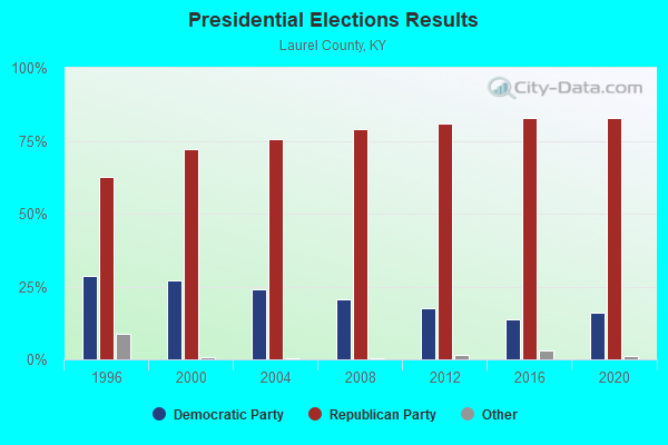
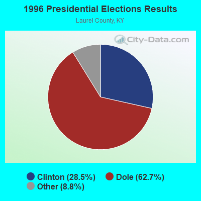
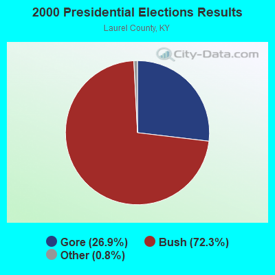
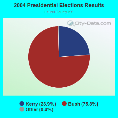
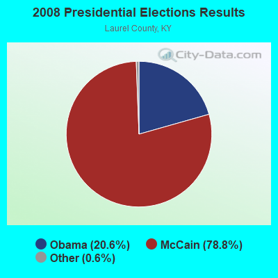
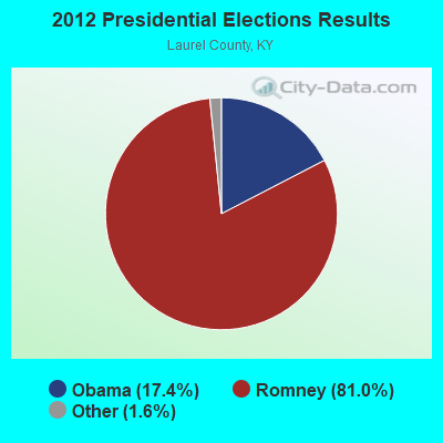

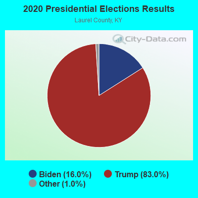
Graphs represent county-level data. Detailed 2008 Election Results
Religion statistics for Camp Ground, KY (based on Laurel County data)
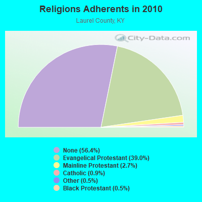
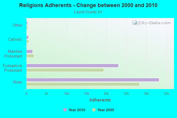
| Religion | Adherents | Congregations |
|---|---|---|
| Evangelical Protestant | 22,963 | 80 |
| Mainline Protestant | 1,579 | 8 |
| Catholic | 512 | 1 |
| Other | 309 | 2 |
| Black Protestant | 290 | 2 |
| None | 33,196 | - |
Food Environment Statistics:
| This county: | 2.79 / 10,000 pop. |
| Kentucky: | 2.19 / 10,000 pop. |
| Laurel County: | 0.35 / 10,000 pop. |
| Kentucky: | 0.25 / 10,000 pop. |
| Here: | 0.17 / 10,000 pop. |
| Kentucky: | 0.74 / 10,000 pop. |
| Here: | 5.06 / 10,000 pop. |
| Kentucky: | 4.36 / 10,000 pop. |
| Laurel County: | 5.23 / 10,000 pop. |
| Kentucky: | 5.74 / 10,000 pop. |
| This county: | 13.0% |
| State: | 11.0% |
| This county: | 35.1% |
| State: | 30.0% |
| Here: | 18.5% |
| Kentucky: | 15.9% |
Strongest AM radio stations in Camp Ground:
- WKDP (1330 AM; 5 kW; CORBIN, KY; Owner: EUBANKS BROADCASTING, INC.)
- WKLB (1290 AM; 5 kW; MANCHESTER, KY; Owner: BARKER BROADCASTING COMPANY, INC.)
- WKVL (850 AM; daytime; 50 kW; KNOXVILLE, TN; Owner: HORNE RADIO, LLC)
- WEKC (710 AM; daytime; 4 kW; WILLIAMSBURG, KY; Owner: GERALD PARKS)
- WCTT (680 AM; 1 kW; CORBIN, KY; Owner: ENCORE COMMUNICATIONS, INC)
- WFTG (1400 AM; 1 kW; LONDON, KY; Owner: F.T.G. BROADCASTING, INC.)
- WYWY (950 AM; 1 kW; BARBOURVILLE, KY; Owner: BARBOURVILLE-COMMNITY BROADC/G CO IN)
- WHAS (840 AM; 50 kW; LOUISVILLE, KY; Owner: CLEAR CHANNEL BROADCASTING LICENSES, INC.)
- WGWM (980 AM; 1 kW; LONDON, KY; Owner: WGWM BROADCASTING, INC.)
- WMIK (560 AM; 2 kW; MIDDLESBORO, KY; Owner: GATEWAY BROADCASTING, INC.)
- WWXL (1450 AM; 1 kW; MANCHESTER, KY; Owner: THE PROMISE PARTNERSHIP)
- WFSR (970 AM; 5 kW; HARLAN, KY; Owner: EASTERN BROADCASTING COMPAY)
- WEZJ (1440 AM; 2 kW; WILLIAMSBURG, KY; Owner: WHITLEY BROADCASTING CO., INC.)
Strongest FM radio stations in Camp Ground:
- WKDP-FM (99.5 FM; CORBIN, KY; Owner: EUBANKS BROADCASTING, INC.)
- WWLT (103.1 FM; MANCHESTER, KY; Owner: VERNON R. BALDWIN, INC.)
- WYGE (92.3 FM; LONDON, KY; Owner: ETHEL HUFF BROADCASTING, LLC)
- WCTT-FM (107.3 FM; CORBIN, KY; Owner: ENCORE COMMUNICATIONS, INC.)
- WVCT (91.5 FM; KEAVY, KY; Owner: VICTORY TRAINING SCHOOL CORP.)
- WWEL (103.9 FM; LONDON, KY; Owner: F.T.G. BROADCASTING, INC.)
- WTBK (105.7 FM; MANCHESTER, KY; Owner: MANCHESTER COMMUNICATIONS, INC.)
- WMIK-FM (92.7 FM; MIDDLESBORO, KY; Owner: GATEWAY BROADCASTING, INC.)
- WEKX (102.7 FM; JELLICO, TN; Owner: WHITLEY BROADCASTING CO., INC.)
- WRIL (106.3 FM; PINEVILLE, KY; Owner: PINE HILLS BROADCASTING, INC.)
- WKKQ (96.1 FM; BARBOURVILLE, KY; Owner: BARBOURVILLE COMMUNITY B/NG CO.INC.)
- WEZJ-FM (104.3 FM; WILLIAMSBURG, KY; Owner: WHITLEY BROADCASTING CO., INC.)
- WSGS (101.1 FM; HAZARD, KY; Owner: MOUNTAIN BROADCASTING SERVICE, INC.)
- WSEH (102.7 FM; CUMBERLAND, KY; Owner: CUMBERLAND CITY BROADCASTING, INC.)
- WDVX (89.9 FM; CLINTON, TN; Owner: CUMBERLAND COMMUNITIES COMMUNI CORP.)
- WTUK (105.1 FM; HARLAN, KY; Owner: EASTERN BROADCASTING COMPANY)
- WZQQ (97.9 FM; HYDEN, KY; Owner: LESLIE COUNTY BROADCASTING, INC.)
- WJMD (104.7 FM; HAZARD, KY; Owner: HAZARD BROADCASTING SERVICES)
- WCTU (105.9 FM; TAZEWELL, TN; Owner: STAIR COMPANY, INC)
- WEKH (90.9 FM; HAZARD, KY; Owner: EASTERN KENTUCKY UNIVERSITY)
TV broadcast stations around Camp Ground:
- W33BK (Channel 33; CORBIN, KY; Owner: TRINITY BROADCASTING NETWORK)
- WVTN-LP (Channel 48; CORBIN, KY; Owner: VICTORY TRAINING SCHOOL CORP.)
- W39CK (Channel 20; CORBIN, KY; Owner: DEREK RAY EUBANKS)
- W26BK (Channel 26; TALBERT, KY; Owner: MS COMMUNICATIONS, LLC)
- WOBZ-LP (Channel 9; EAST BERNSTADT, ETC., KY; Owner: ANDREA JOY KESLER)
- WLJC-TV (Channel 65; BEATTYVILLE, KY; Owner: HOUR OF HARVEST, INC.)

- 67.0%Electricity
- 11.9%Bottled, tank, or LP gas
- 8.5%Fuel oil, kerosene, etc.
- 4.6%Wood
- 4.2%Utility gas
- 3.5%Coal or coke
- 0.4%No fuel used

- 64.7%Electricity
- 10.1%Utility gas
- 10.1%Coal or coke
- 6.9%Bottled, tank, or LP gas
- 4.6%Wood
- 3.7%Fuel oil, kerosene, etc.
Camp Ground compared to Kentucky state average:
- Unemployed percentage below state average.
- Black race population percentage significantly below state average.
- Hispanic race population percentage significantly below state average.
- Median age below state average.
- Foreign-born population percentage significantly below state average.
- Length of stay since moving in significantly above state average.
- Number of rooms per house significantly below state average.
- House age significantly below state average.
- Number of college students below state average.
- Percentage of population with a bachelor's degree or higher significantly below state average.