Diamond, Oregon
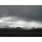
Diamond: Storm over the Steens.......
Diamond: In The Steens.....
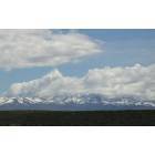
Diamond: Snow on the Trout Creek Mtns....
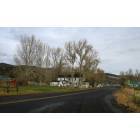
Diamond: Frenchglen...
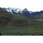
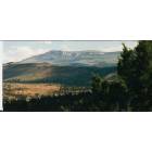
Diamond: the Steens Mtns.......
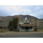
Diamond: Business opportunity....Pueblo Mtns in background....
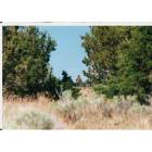
Diamond: In the High Desert.....

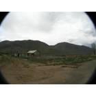
Diamond: Dirt Road In The Steens.....
Diamond: On the Nevada Border.....
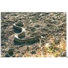
Diamond: Ornery Local Resident.....
Diamond: Rock Cairn....
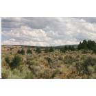
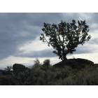
Diamond: Sagebrush & Juniper....
- add
your
Submit your own pictures of this place and show them to the world
- OSM Map
- General Map
- Google Map
- MSN Map

| Males: 303 | |
| Females: 280 |
| Median resident age: | 38.6 years |
| Oregon median age: | 36.3 years |
Zip code: 97736
| Diamond: | $42,816 |
| OR: | $75,657 |
Estimated per capita income in 2022: $23,823 (it was $14,080 in 2000)
Diamond CCD income, earnings, and wages data
Estimated median house or condo value in 2022: $467,470 (it was $181,300 in 2000)
| Diamond: | $467,470 |
| OR: | $475,600 |
Detailed information about poverty and poor residents in Diamond, OR


- 60491.8%White alone
- 406.1%Hispanic
- 91.4%Two or more races
- 30.5%American Indian alone
- 20.3%Asian alone

Races in Diamond detailed stats: ancestries, foreign born residents, place of birth
 Recent articles from our blog. Our writers, many of them Ph.D. graduates or candidates, create easy-to-read articles on a wide variety of topics.
Current Local Time: PST time zone
Elevation: 4212 feet
Land area: 6901.2 square miles.
Population density: 0.08 people per square mile (very low).

| Diamond CCD: | 0.4% ($700) |
| Oregon: | 1.2% ($1,687) |
Nearest city with pop. 50,000+: Nampa, ID  (137.1 miles , pop. 51,867).
Nearest city with pop. 200,000+: Northwest Clackamas, OR (249.2 miles , pop. 224,220).
Nearest city with pop. 1,000,000+: Los Angeles, CA (606.5 miles , pop. 3,694,820).
Nearest cities:
Latitude: 42.84 N, Longitude: 119.09 W


| Here: | 4.5% |
| Oregon: | 3.9% |

- Agriculture, forestry, fishing & hunting (61.5%)
- Educational services (10.8%)
- Public administration (5.1%)
- Accommodation & food services (4.8%)
- Construction (3.2%)
- Transportation equipment (1.9%)
- Health care (1.9%)

- Agriculture, forestry, fishing & hunting (71.0%)
- Public administration (6.8%)
- Accommodation & food services (5.3%)
- Construction (4.8%)
- Transportation equipment (2.9%)
- Educational services (2.9%)
- Metal & metal products (1.9%)

- Agriculture, forestry, fishing & hunting (43.0%)
- Educational services (26.2%)
- Health care (5.6%)
- Professional, scientific, technical services (3.7%)
- Social assistance (3.7%)
- Accommodation & food services (3.7%)
- Building material & garden equipment & supplies dealers (2.8%)

- Farmers and farm managers (28.3%)
- Agricultural workers, including supervisors (28.3%)
- Teachers, secondary school (4.1%)
- Building and grounds cleaning and maintenance occupations (3.2%)
- Cooks and food preparation workers (3.2%)
- Construction traders workers except carpenters, electricians, painters, plumbers, and construction laborers (2.9%)
- Other management occupations, except farmers and farm managers (2.5%)

- Agricultural workers, including supervisors (35.7%)
- Farmers and farm managers (32.9%)
- Construction traders workers except carpenters, electricians, painters, plumbers, and construction laborers (4.3%)
- Building and grounds cleaning and maintenance occupations (2.9%)
- Other management occupations, except farmers and farm managers (2.4%)
- Material recording, scheduling, dispatching, and distributing workers (2.4%)
- Carpenters (2.4%)

- Farmers and farm managers (19.6%)
- Agricultural workers, including supervisors (14.0%)
- Teachers, secondary school (9.3%)
- Cooks and food preparation workers (6.5%)
- Counselors, social workers, and other community and social service specialists (5.6%)
- Bookkeeping, accounting, and auditing clerks (5.6%)
- Preschool, kindergarten, elementary, and middle school teachers (3.7%)
Average climate in Diamond, Oregon
Based on data reported by over 4,000 weather stations


Earthquake activity:
Diamond-area historical earthquake activity is significantly above Oregon state average. It is 3071% greater than the overall U.S. average.On 10/3/1915 at 06:52:48, a magnitude 7.6 (7.6 UK, Class: Major, Intensity: VIII - XII) earthquake occurred 181.2 miles away from the city center
On 4/18/1906 at 13:12:21, a magnitude 7.9 (7.9 UK) earthquake occurred 392.8 miles away from the city center, causing $524,000,000 total damage
On 10/28/1983 at 14:06:06, a magnitude 7.3 (6.2 MB, 7.3 MS, 7.0 MW) earthquake occurred 278.8 miles away from the city center, causing 2 deaths (2 shaking deaths) and 3 injuries, causing $15,000,000 total damage
On 1/31/1922 at 13:17:28, a magnitude 7.6 (7.6 UK) earthquake occurred 364.7 miles away from Diamond center
On 11/8/1980 at 10:27:34, a magnitude 7.2 (6.2 MB, 7.2 MS, 7.2 MW, 7.0 ML) earthquake occurred 293.4 miles away from Diamond center
On 12/16/1954 at 11:07:12, a magnitude 7.0 (7.0 UK) earthquake occurred 257.8 miles away from the city center
Magnitude types: body-wave magnitude (MB), local magnitude (ML), surface-wave magnitude (MS), moment magnitude (MW)
Natural disasters:
The number of natural disasters in Harney County (6) is a lot smaller than the US average (15).Major Disasters (Presidential) Declared: 3
Emergencies Declared: 2
Causes of natural disasters: Drought: 1, Fire: 1, Flood: 1, Heavy Rain: 1, Hurricane: 1, Winter Storm: 1, Other: 1 (Note: some incidents may be assigned to more than one category).
Airports located in Diamond:
- Barton Lake Ranch Airport (OR08) (Runways: 1)
Colleges/universities with over 2000 students nearest to Diamond:
- Treasure Valley Community College (about 135 miles; Ontario, OR; Full-time enrollment: 2,055)
- Northwest Nazarene University (about 137 miles; Nampa, ID; FT enrollment: 2,290)
- College of Western Idaho (about 141 miles; Nampa, ID; FT enrollment: 6,300)
- Central Oregon Community College (about 142 miles; Bend, OR; FT enrollment: 5,217)
- Oregon Institute of Technology (about 144 miles; Klamath Falls, OR; FT enrollment: 2,900)
- Boise State University (about 155 miles; Boise, ID; FT enrollment: 16,774)
- Eastern Oregon University (about 179 miles; La Grande, OR; FT enrollment: 3,127)
Public elementary/middle school in Diamond:
- DIAMOND ELEMENTARY SCHOOL (Students: 16, Location: 40524 S DIAMOND LN, Grades: KG-8)
Points of interest:
Notable locations in Diamond: Moon Reservoir Recreation Site Boat Ramp (A), Madarieta Cabin (B), Smyth Ranch (C), M S Davies Ranch (D), Lucky Star Mine (E), Lower Bacon Camp (F), Krumbo Reservoir Boat Ramp (G), Lauserica Camp (H), East Mann Lake Boat Access (I), Kueny Ranch (J), Koontz Homestead (K), Juniper Park Ranch (L), Juniper Grade (M), Iven Stephens Homestead (N), Huffman Camp (O), Stewart Homestead (P), Home Creek Ranch (Q), Hemmy Cabin (R), H L Ranch (S), Mogul Mine (T). Display/hide their locations on the map
Cemeteries: Smyth Cemetery (1), Rock Creek Cemetery (2), Denio Cemetery (3), Andrews Cemetery (4). Display/hide their locations on the map
Lakes, reservoirs, and swamps: Glenns Hole (A), Grassy Lake (B), Gravel Waterhole (C), Ham Brown Lake (D), Ham Waterhole (E), Harney Lake (F), Heath Lake (G), Hole in the Ground Lake (H). Display/hide their locations on the map
Streams, rivers, and creeks: Virginia Creek (A), Catlow Creek (B), Smokeout Creek (C), Jim Creek (D), French Creek (E), Dip Creek (F), Dugout Creek (G), Cherry Creek (H), Colony Creek (I). Display/hide their locations on the map
Parks in Diamond include: Pueblo Mountains Wilderness Study Area (1), Frenchglen Hotel State Park (2), Steens Mountain Cooperative Management and Protection Area (3). Display/hide their locations on the map
Tourist attraction: Round Barn Visitor Center (Historical Places & Services; 91555 Lava Bed Road) (1). Display/hide its approximate location on the map
Hotel: Hotel Diamond (49130 Happy Valley Road) (1). Display/hide its approximate location on the map
| This place: | 2.4 people |
| Oregon: | 2.5 people |
| This place: | 71.2% |
| Whole state: | 63.4% |
| This place: | 3.6% |
| Whole state: | 8.0% |
No gay or lesbian households reported
| This place: | 14.8% |
| Whole state: | 11.6% |
| This place: | 9.2% |
| Whole state: | 5.0% |
For population 15 years and over in Diamond:

- Never married: 21.0%
- Now married: 65.8%
- Separated: 0.8%
- Widowed: 3.1%
- Divorced: 10.1%
For population 25 years and over in Diamond:
- High school or higher: 84.8%
- Bachelor's degree or higher: 17.1%
- Graduate or professional degree: 3.7%
- Unemployed: 2.5%
- Mean travel time to work (commute): 15.3 minutes


| Here: | 9.7 |
| Oregon average: | 11.5 |
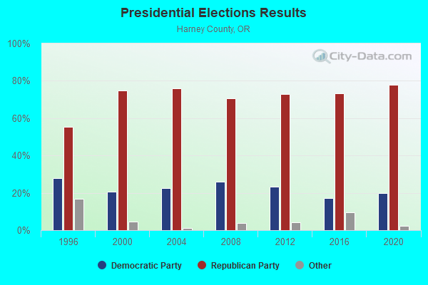
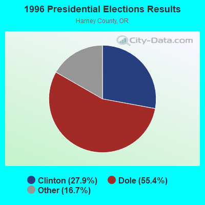
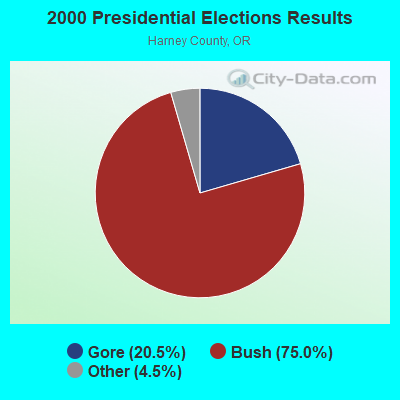
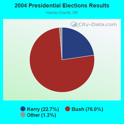
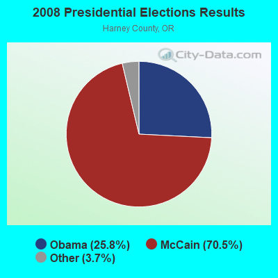

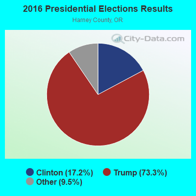
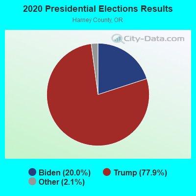
Graphs represent county-level data. Detailed 2008 Election Results
Religion statistics for Diamond, OR (based on Harney County data)
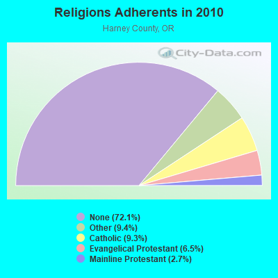
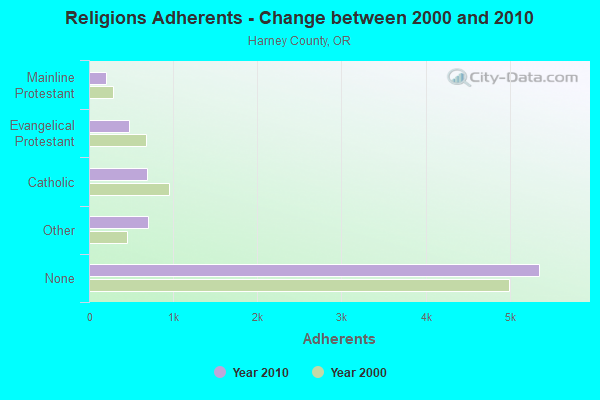
| Religion | Adherents | Congregations |
|---|---|---|
| Other | 697 | 3 |
| Catholic | 689 | 3 |
| Evangelical Protestant | 480 | 9 |
| Mainline Protestant | 202 | 4 |
| None | 5,354 | - |
Food Environment Statistics:
| Harney County: | 2.96 / 10,000 pop. |
| Oregon: | 2.03 / 10,000 pop. |
| This county: | 4.43 / 10,000 pop. |
| Oregon: | 1.69 / 10,000 pop. |
| This county: | 8.87 / 10,000 pop. |
| Oregon: | 9.93 / 10,000 pop. |
| Harney County: | 9.5% |
| Oregon: | 7.4% |
| Harney County: | 23.9% |
| Oregon: | 25.6% |
| This county: | 9.1% |
| State: | 14.2% |
Strongest AM radio stations in Diamond:
- KBOI (670 AM; 50 kW; BOISE, ID; Owner: CITADEL BROADCASTING COMPANY)
- KWEI (1260 AM; 50 kW; WEISER, ID; Owner: TREASURE VALLEY BROADCASTING CO.)
- KKOH (780 AM; 50 kW; RENO, NV; Owner: CITADEL BROADCASTING COMPANY)
- KPOJ (620 AM; 50 kW; PORTLAND, OR; Owner: CITICASTERS LICENSES, L.P.)
- KXL (750 AM; 50 kW; PORTLAND, OR; Owner: ROSE CITY RADIO CORPORATION)
- KPNW (1120 AM; 50 kW; EUGENE, OR; Owner: CAPSTAR TX LIMITED PARTNERSHIP)
- KBSU (730 AM; 15 kW; BOISE, ID; Owner: IDAHO STATE BOARD OF EDUCATION)
- KPAM (860 AM; 50 kW; TROUTDALE, OR; Owner: PAMPLIN BROADCASTING-OREGON, INC.)
- KOTK (1080 AM; 50 kW; PORTLAND, OR; Owner: FISHER BROADCASTING - PORTLAND RADIO, L.L.C.)
- KDUN (1030 AM; 50 kW; REEDSPORT, OR; Owner: PAMPLIN BROADCASTING-OREGON, INC.)
- KGRV (700 AM; 25 kW; WINSTON, OR; Owner: PACIFIC CASCADE COMMUNICATIONS CORP.)
- KEX (1190 AM; 50 kW; PORTLAND, OR; Owner: CITICASTERS LICENSES, L.P.)
- KTBI (810 AM; daytime; 50 kW; EPHRATA, WA; Owner: TACOMA BROADCASTERS, INCORPORATED)
FCC Registered Microwave Towers:
2- DMD TWR, Lat: 43.034583 Lon: -118.678667, Type: Upole, Structure height: 21.3 m, Overall height: 22.9 m, Call Sign: WQMC950,
Assigned Frequencies: 3650.00 MHz, Grant Date: 07/01/2010, Expiration Date: 10/17/2020, Cancellation Date: 12/19/2020, Certifier: Justin Chase, Registrant: Grase Communications LLC Dba Miwave, 1804 W. Monroe St., Burns, OR 97720, Phone: (503) 481-0012, Email:
- DMD TWR, Old Diamond Tv Tower Site (Lat: 43.034583 Lon: -118.678667), Type: Upole, Structure height: 21.3 m, Overall height: 22.9 m, Call Sign: WQQK640,
Assigned Frequencies: 10735.0 MHz, 10735.0 MHz, 10735.0 MHz, 10735.0 MHz, 10735.0 MHz, 10735.0 MHz, 10775.0 MHz, 10775.0 MHz, 10775.0 MHz, 10775.0 MHz... (+14 more), Grant Date: 01/19/2023, Expiration Date: 01/15/2033, Certifier: Justin Chase, Registrant: Micronet Communications, Inc., 812 Lexington Dr, Plano, TX 75075, Phone: (972) 422-7200, Email:
FCC Registered Amateur Radio Licenses:
1- Call Sign: KF7ZXI, Licensee ID: L01749729, Grant Date: 11/30/2012, Expiration Date: 11/30/2022, Certifier: Michael D Largent, Registrant: Michael D Largent, 39131 S Diamond Ln, Diamond, OR 97722-9307
FAA Registered Aircraft:
1- Aircraft: HUGHES 269C (Category: Land, Seats: 3, Weight: Up to 12,499 Pounds, Speed: 64 mph), Engine: LYCOMING HIO-360 SER (205 HP) (Reciprocating)
N-Number: 58174, N58174, N-58174, Serial Number: 480685, Airworthiness Date: 05/31/1978, Certificate Issue Date: 06/05/2013
Registrant (Corporation): Jenkins Ranches Inc, 51426 Lava Bed Rd, Diamond, OR 97722

- 50.0%Electricity
- 25.7%Wood
- 24.3%Fuel oil, kerosene, etc.

- 61.3%Electricity
- 26.1%Wood
- 12.6%Fuel oil, kerosene, etc.
Diamond compared to Oregon state average:
- Median household income below state average.
- Unemployed percentage significantly below state average.
- Black race population percentage significantly below state average.
- Hispanic race population percentage below state average.
- Foreign-born population percentage significantly below state average.
- Length of stay since moving in significantly above state average.
- Number of rooms per house significantly below state average.
- House age significantly below state average.
- Number of college students significantly below state average.
- Percentage of population with a bachelor's degree or higher below state average.
Diamond on our top lists:
- #3 on the list of "Top 100 cities with largest land areas"