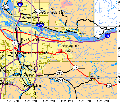
Gresham, Oregon

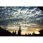
Gresham: Sunset as seen from my deck.
Gresham: Sunrise as seen from my deck.

Gresham: road to Percimmon golf course
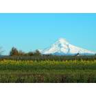
Gresham: a view of mt. hood from se gresham
- add
your
Submit your own pictures of this city and show them to the world
- OSM Map
- General Map
- Google Map
- MSN Map
Population change since 2000: +23.7%
 |
| Males: 55,729 | |
| Females: 55,892 |
| Median resident age: | 40.5 years |
| Oregon median age: | 40.5 years |
Zip codes: 97030, 97060, 97080, 97233, 97236.
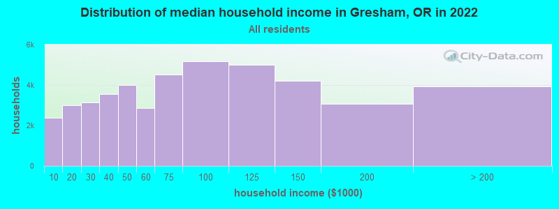
Gresham Zip Code Map| Gresham: | $71,006 |
| OR: | $75,657 |
Estimated per capita income in 2022: $39,580 (it was $19,588 in 2000)
Gresham city income, earnings, and wages data
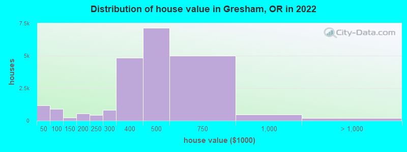
Estimated median house or condo value in 2022: $446,000 (it was $155,800 in 2000)
| Gresham: | $446,000 |
| OR: | $475,600 |
Mean prices in 2022: all housing units: $414,799; detached houses: $451,436; townhouses or other attached units: $307,933; in 2-unit structures: $235,684; in 3-to-4-unit structures: $310,903; in 5-or-more-unit structures: $268,342; mobile homes: $63,102; occupied boats, rvs, vans, etc.: $650,518
Median gross rent in 2022: $1,386.
(7.5% for White Non-Hispanic residents, 21.6% for Black residents, 20.1% for Hispanic or Latino residents, 10.0% for American Indian residents, 25.1% for Native Hawaiian and other Pacific Islander residents, 19.9% for other race residents, 20.0% for two or more races residents)
Detailed information about poverty and poor residents in Gresham, OR


Compare current foreclosures in Gresham, OR:
| Photo | Address | Area | Beds / Baths | Price | Details |
|---|---|---|---|---|---|

|
#1
NW 14th Pl
Gresham, OR 97030
|
1,260 sq. feet
|
1 baths 3 beds |
show details | |

|
#2
SE Powell Valley Rd
Gresham, OR 97080
|
3,406 sq. feet
|
2 baths 5 beds |
show details | |

|
#3
SE 214th Ave
Gresham, OR 97030
|
1,294 sq. feet
|
2 baths 3 beds |
show details | |

|
#4
NE 18th St
Gresham, OR 97030
|
943 sq. feet
|
1 baths 3 beds |
show details | |

|
#5
NE Village Squire Ave # 6
Gresham, OR 97030
|
1,147 sq. feet
|
1 baths 3 beds |
show details | |

|
#6
SW Myers Pl
Gresham, OR 97080
|
1,651 sq. feet
|
2 baths 3 beds |
show details | |

|
#7
SW Brixton Dr
Gresham, OR 97080
|
2,846 sq. feet
|
3 baths 5 beds |
show details | |

|
#8
SW Riverview Pl
Gresham, OR 97080
|
1,438 sq. feet
|
2 baths 3 beds |
show details | |

|
#9
SW Riverview Ave
Gresham, OR 97080
|
1,799 sq. feet
|
2 baths 3 beds |
show details | |

|
#10
SE Condor Dr
Gresham, OR 97080
|
2,420 sq. feet
|
3 baths 3 beds |
show details |
| Photo | Address | Area | Beds / Baths | Price | Details |
|---|---|---|---|---|---|

|
#11
NE Maple Ct
Gresham, OR 97030
|
1,876 sq. feet
|
2 baths 3 beds |
show details | |

|
#12
SW 26th Ct
Gresham, OR 97080
|
4,799 sq. feet
|
3 baths 3 beds |
show details | |

|
#13
SW 26th Ct
Gresham, OR 97080
|
1,829 sq. feet
|
2 baths 3 beds |
show details | |

|
#14
SE Paloma Ct
Gresham, OR 97080
|
1,920 sq. feet
|
2 baths 3 beds |
show details | |

|
#15
NE Barnes Ct
Gresham, OR 97030
|
2,750 sq. feet
|
2 baths 4 beds |
show details | |

|
#16
SE Juniper Ave
Gresham, OR 97080
|
912 sq. feet
|
1 baths 3 beds |
show details | |

|
#17
SE Evelyn Ct
Gresham, OR 97080
|
1,040 sq. feet
|
1 baths 3 beds |
show details | |

|
#18
SE 3rd St
Gresham, OR 97080
|
1,396 sq. feet
|
2 baths 3 beds |
show details | |

|
#19
SE 24th Ter
Gresham, OR 97080
|
1,377 sq. feet
|
2 baths 3 beds |
show details | |

|
#20
NE Fleming Ter
Gresham, OR 97030
|
1,922 sq. feet
|
2 baths 5 beds |
show details |
| Photo | Address | Area | Beds / Baths | Price | Details |
|---|---|---|---|---|---|

|
#21
SE Williams Dr
Gresham, OR 97080
|
1,921 sq. feet
|
2 baths 3 beds |
show details | |

|
#22
SW Lillyben Ave
Gresham, OR 97080
|
1,518 sq. feet
|
2 baths 3 beds |
show details | |

|
#23
NE 5th Ct
Gresham, OR 97030
|
1,996 sq. feet
|
3 baths 3 beds |
show details | |

|
#24
SE 15th Dr
Gresham, OR 97080
|
1,056 sq. feet
|
2 baths 3 beds |
show details | |

|
#25
NE 17th St
Gresham, OR 97030
|
1,404 sq. feet
|
1 baths 3 beds |
show details | |

|
#26
SW 20th Ct
Gresham, OR 97080
|
2,688 sq. feet
|
2 baths 4 beds |
show details | |

|
#27
NE Kane Dr
Gresham, OR 97030
|
903 sq. feet
|
1 baths 2 beds |
show details | |

|
#28
NE 29th St
Gresham, OR 97030
|
1,370 sq. feet
|
2 baths 2 beds |
show details | |

|
#29
SW Brixton Pl
Gresham, OR 97080
|
1,771 sq. feet
|
1 baths 3 beds |
show details | |

|
#30
SW 14th St
Gresham, OR 97080
|
3,208 sq. feet
|
3 baths 6 beds |
show details |
| Photo | Address | Area | Beds / Baths | Price | Details |
|---|---|---|---|---|---|

|
#31
SW Junction Pl
Gresham, OR 97080
|
970 sq. feet
|
2 baths 3 beds |
show details | |

|
#32
SE Quail Dr
Gresham, OR 97080
|
2,060 sq. feet
|
2 baths 3 beds |
show details | |

|
#33
SE 31st St
Gresham, OR 97080
|
1,985 sq. feet
|
3 baths 4 beds |
show details | |

|
#34
SW Wonderview Dr
Gresham, OR 97080
|
2,640 sq. feet
|
3 baths 3 beds |
show details | |

|
#35
NE 23rd Pl
Gresham, OR 97030
|
1,120 sq. feet
|
1 baths 3 beds |
show details | |

|
#36
SE 208th Ave
Gresham, OR 97030
|
2,072 sq. feet
|
2 baths 4 beds |
show details | |

|
#37
NE Village Squire A 10
Gresham, OR 97030
|
1,720 sq. feet
|
2 baths 3 beds |
show details | |

|
#38
NW Angeline Ave
Gresham, OR 97030
|
1,031 sq. feet
|
1 baths 2 beds |
show details | |

|
#39
W Powell Blvd
Gresham, OR 97030
|
2,241 sq. feet
|
3 baths 4 beds |
show details | |

|
#40
SE 210th Ave
Gresham, OR 97030
|
1,320 sq. feet
|
1 baths 3 beds |
show details |
| Photo | Address | Area | Beds / Baths | Price | Details |
|---|---|---|---|---|---|

|
#41
NE Linden Ave Apt B17
Gresham, OR 97030
|
2,284 sq. feet
|
1 baths 2 beds |
show details | |

|
#42
NW 7th Pl
Gresham, OR 97030
|
2,430 sq. feet
|
2 baths 3 beds |
show details | |

|
#43
SE Mimosa Dr
Gresham, OR 97080
|
1,999 sq. feet
|
2 baths 3 beds |
show details | |

|
#44
NW 4th St
Gresham, OR 97030
|
2,404 sq. feet
|
2 baths 2 beds |
show details | |

|
#45
W Powell Blvd Unit 246
Gresham, OR 97030
|
1,052 sq. feet
|
2 baths 2 beds |
show details | |

|
#46
SE 225th Ave
Gresham, OR 97030
|
1,886 sq. feet
|
2 baths 4 beds |
show details | |

|
#47
SW Chastain Ave
Gresham, OR 97080
|
2,436 sq. feet
|
3 baths 5 beds |
show details | |

|
#48
SE Olvera Pl
Gresham, OR 97080
|
2,128 sq. feet
|
3 baths 4 beds |
show details | |

|
#49
SW Ivory Loop
Gresham, OR 97080
|
1,218 sq. feet
|
2 baths 3 beds |
show details | |

|
Check over 1 million property listings on Foreclosure.com!
|
browse all offers | |||


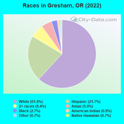
- 69,04061.8%White alone
- 24,17421.7%Hispanic
- 7,1476.4%Two or more races
- 5,5885.0%Asian alone
- 3,0372.7%Black alone
- 1,0440.9%American Indian alone
- 7800.7%Native Hawaiian and Other
Pacific Islander alone - 8240.7%Other race alone
Races in Gresham detailed stats: ancestries, foreign born residents, place of birth
According to our research of Oregon and other state lists, there were 18 registered sex offenders living in Gresham, Oregon as of May 19, 2024.
The ratio of all residents to sex offenders in Gresham is 6,196 to 1.
The ratio of registered sex offenders to all residents in this city is much lower than the state average.
The City-Data.com crime index weighs serious crimes and violent crimes more heavily. Higher means more crime, U.S. average is 246.1. It adjusts for the number of visitors and daily workers commuting into cities.
- means the value is smaller than the state average.- means the value is about the same as the state average.
- means the value is bigger than the state average.
- means the value is much bigger than the state average.
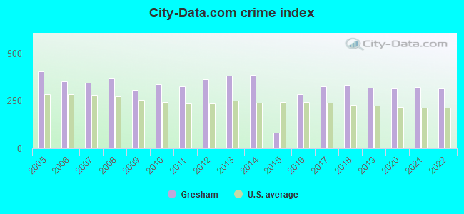
Crime rate in Gresham detailed stats: murders, rapes, robberies, assaults, burglaries, thefts, arson
Full-time law enforcement employees in 2021, including police officers: 141 (115 officers - 108 male; 7 female).
| Officers per 1,000 residents here: | 1.04 |
| Oregon average: | 1.48 |
 Recent articles from our blog. Our writers, many of them Ph.D. graduates or candidates, create easy-to-read articles on a wide variety of topics.

 | I've Got To Ask (90 replies) |
| Portland mentioned again as possible MLB town (177 replies) |
| Moving to Oregon - Corvallis/McMinnville, Scappoose, Gresham (16 replies) |
| What's the "good" part of Gresham? (13 replies) |
| Is all of Gresham high crime? (11 replies) |
| Wondering about Crime in south Gresham (6 replies) |
Latest news from Gresham, OR collected exclusively by city-data.com from local newspapers, TV, and radio stations
Gresham, OR City Guides:
Ancestries: German (6.9%), American (5.0%), English (4.6%), Irish (4.0%), European (3.3%), Ukrainian (2.3%).
Current Local Time: PST time zone
Incorporated in 1904
Elevation: 323 feet
Land area: 22.2 square miles.
Population density: 5,038 people per square mile (average).
19,269 residents are foreign born (7.9% Latin America, 4.1% Asia, 2.7% Europe).
| This city: | 17.3% |
| Oregon: | 9.8% |
Median real estate property taxes paid for housing units with mortgages in 2022: $3,894 (0.9%)
Median real estate property taxes paid for housing units with no mortgage in 2022: $3,768 (0.9%)
Nearest city with pop. 200,000+: Portland, OR  (9.8 miles , pop. 529,121).
Nearest city with pop. 1,000,000+: Los Angeles, CA (818.4 miles , pop. 3,694,820).
Nearest cities:
), ), Latitude: 45.50 N, Longitude: 122.44 W
Daytime population change due to commuting: -22,291 (-20.0%)
Workers who live and work in this city: 20,532 (34.3%)
Area codes: 503, 971
Property values in Gresham, OR

Gresham, Oregon accommodation & food services, waste management - Economy and Business Data
Single-family new house construction building permits:
- 2022: 252 buildings, average cost: $286,800
- 2021: 221 buildings, average cost: $264,200
- 2020: 84 buildings, average cost: $263,600
- 2019: 205 buildings, average cost: $250,700
- 2018: 190 buildings, average cost: $273,200
- 2017: 111 buildings, average cost: $262,000
- 2016: 110 buildings, average cost: $278,200
- 2015: 182 buildings, average cost: $265,600
- 2014: 61 buildings, average cost: $239,400
- 2013: 75 buildings, average cost: $259,800
- 2012: 66 buildings, average cost: $251,900
- 2011: 42 buildings, average cost: $215,500
- 2010: 76 buildings, average cost: $223,700
- 2009: 69 buildings, average cost: $207,600
- 2008: 103 buildings, average cost: $219,200
- 2007: 305 buildings, average cost: $228,200
- 2006: 242 buildings, average cost: $242,000
- 2005: 350 buildings, average cost: $226,200
- 2004: 373 buildings, average cost: $170,900
- 2003: 401 buildings, average cost: $176,900
- 2002: 461 buildings, average cost: $166,300
- 2001: 471 buildings, average cost: $166,700
- 2000: 319 buildings, average cost: $114,600
- 1999: 443 buildings, average cost: $119,800
- 1998: 287 buildings, average cost: $128,800
- 1997: 305 buildings, average cost: $134,300
| Here: | 3.8% |
| Oregon: | 3.9% |

Population change in the 1990s: +21,721 (+31.7%).
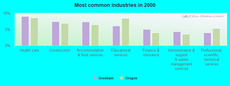
- Health care (9.0%)
- Construction (7.4%)
- Accommodation & food services (7.4%)
- Educational services (6.1%)
- Finance & insurance (5.1%)
- Administrative & support & waste management services (4.4%)
- Professional, scientific, technical services (4.0%)
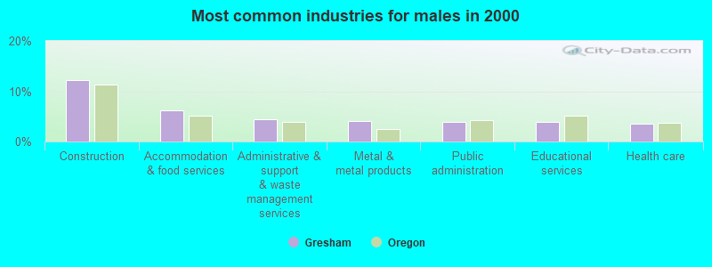
- Construction (12.2%)
- Accommodation & food services (6.2%)
- Administrative & support & waste management services (4.4%)
- Metal & metal products (4.1%)
- Public administration (4.0%)
- Educational services (3.9%)
- Health care (3.5%)
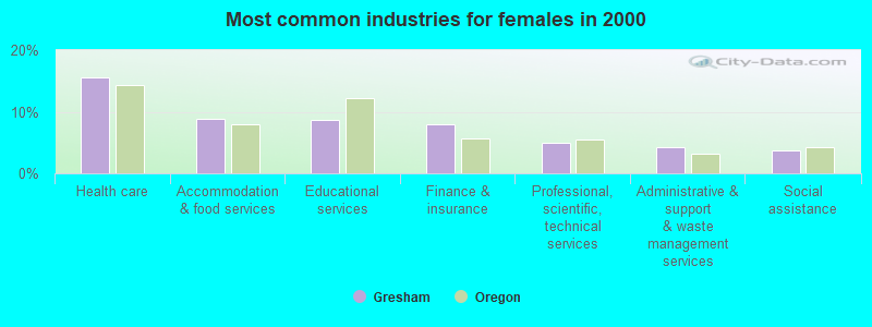
- Health care (15.5%)
- Accommodation & food services (8.8%)
- Educational services (8.8%)
- Finance & insurance (8.0%)
- Professional, scientific, technical services (4.9%)
- Administrative & support & waste management services (4.3%)
- Social assistance (3.8%)
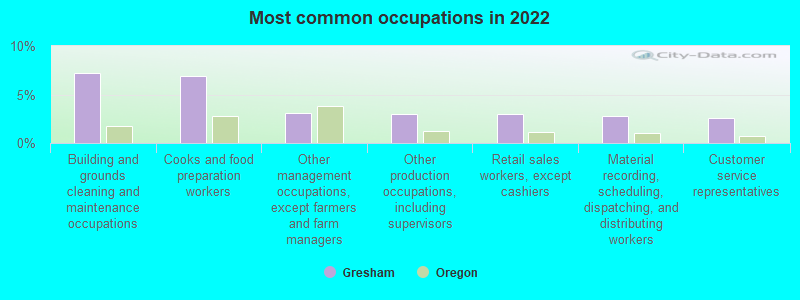
- Building and grounds cleaning and maintenance occupations (7.2%)
- Cooks and food preparation workers (6.9%)
- Other management occupations, except farmers and farm managers (3.1%)
- Other production occupations, including supervisors (3.0%)
- Retail sales workers, except cashiers (3.0%)
- Material recording, scheduling, dispatching, and distributing workers (2.8%)
- Customer service representatives (2.6%)
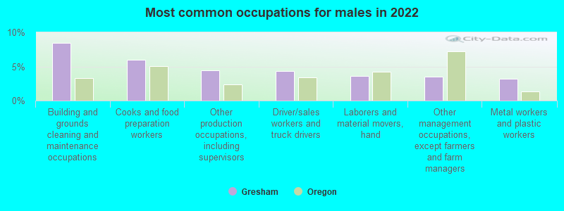
- Building and grounds cleaning and maintenance occupations (8.5%)
- Cooks and food preparation workers (6.0%)
- Other production occupations, including supervisors (4.5%)
- Driver/sales workers and truck drivers (4.3%)
- Laborers and material movers, hand (3.6%)
- Other management occupations, except farmers and farm managers (3.5%)
- Metal workers and plastic workers (3.2%)

- Cooks and food preparation workers (8.0%)
- Building and grounds cleaning and maintenance occupations (5.8%)
- Secretaries and administrative assistants (5.0%)
- Supervisors and other personal care and service workers, except child care workers (4.7%)
- Registered nurses (4.4%)
- Information and record clerks, except customer service representatives (4.3%)
- Customer service representatives (4.1%)
Average climate in Gresham, Oregon
Based on data reported by over 4,000 weather stations


|
|

(lower is better)
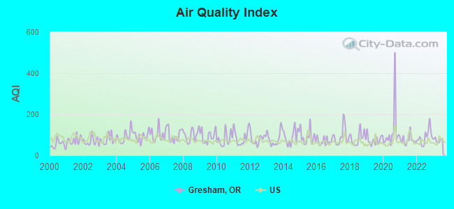
Air Quality Index (AQI) level in 2023 was 74.0. This is about average.
| City: | 74.0 |
| U.S.: | 72.6 |
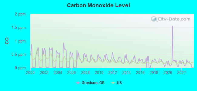
Carbon Monoxide (CO) [ppm] level in 2022 was 0.181. This is better than average. Closest monitor was 7.9 miles away from the city center.
| City: | 0.181 |
| U.S.: | 0.251 |
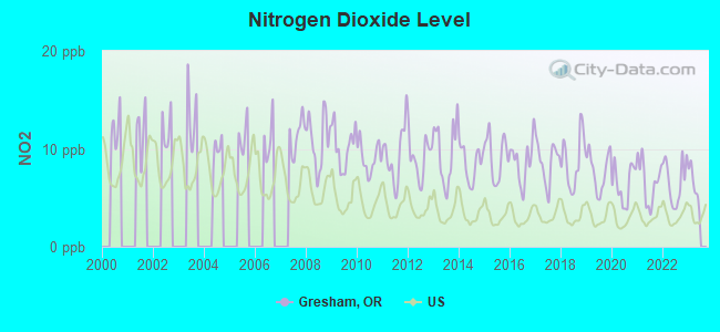
Nitrogen Dioxide (NO2) [ppb] level in 2022 was 6.68. This is worse than average. Closest monitor was 6.4 miles away from the city center.
| City: | 6.68 |
| U.S.: | 5.11 |
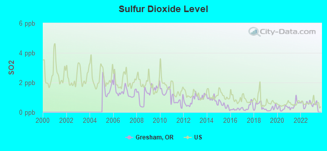
Sulfur Dioxide (SO2) [ppb] level in 2022 was 0.569. This is significantly better than average. Closest monitor was 5.8 miles away from the city center.
| City: | 0.569 |
| U.S.: | 1.515 |
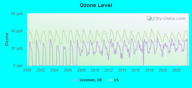
Ozone [ppb] level in 2023 was 26.5. This is better than average. Closest monitor was 6.4 miles away from the city center.
| City: | 26.5 |
| U.S.: | 33.3 |
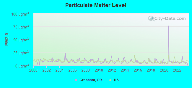
Particulate Matter (PM2.5) [µg/m3] level in 2023 was 5.17. This is significantly better than average. Closest monitor was 6.0 miles away from the city center.
| City: | 5.17 |
| U.S.: | 8.11 |
Lead (Pb) [µg/m3] level in 2003 was 0.00810. This is about average. Closest monitor was 5.0 miles away from the city center.
| City: | 0.00810 |
| U.S.: | 0.00931 |
Earthquake activity:
Gresham-area historical earthquake activity is significantly above Oregon state average. It is 1490% greater than the overall U.S. average.On 4/13/1949 at 19:55:42, a magnitude 7.0 (7.0 UK, Class: Major, Intensity: VIII - XII) earthquake occurred 120.8 miles away from Gresham center, causing $80,000,000 total damage
On 2/28/2001 at 18:54:32, a magnitude 6.8 (6.5 MB, 6.6 MS, 6.8 MW, Class: Strong, Intensity: VII - IX) earthquake occurred 109.9 miles away from Gresham center, causing $2,000,000,000 total damage and $305,000,000 insured losses
On 2/28/2001 at 18:54:32, a magnitude 6.8 (6.8 MD, Depth: 32.2 mi) earthquake occurred 114.6 miles away from the city center
On 4/29/1965 at 15:28:43, a magnitude 6.6 (6.6 UK) earthquake occurred 125.5 miles away from the city center, causing $28,000,000 total damage
On 1/31/1922 at 13:17:28, a magnitude 7.6 (7.6 UK) earthquake occurred 367.5 miles away from Gresham center
On 11/8/1980 at 10:27:34, a magnitude 7.2 (6.2 MB, 7.2 MS, 7.2 MW, 7.0 ML) earthquake occurred 318.0 miles away from the city center
Magnitude types: body-wave magnitude (MB), duration magnitude (MD), local magnitude (ML), surface-wave magnitude (MS), moment magnitude (MW)
Natural disasters:
The number of natural disasters in Multnomah County (9) is smaller than the US average (15).Major Disasters (Presidential) Declared: 7
Emergencies Declared: 1
Causes of natural disasters: Floods: 4, Winter Storms: 3, Landslides: 2, Mudslides: 2, Storms: 2, Winds: 2, Fire: 1, Heavy Rain: 1, Hurricane: 1, Snow: 1, Other: 1 (Note: some incidents may be assigned to more than one category).

Hospitals and medical centers in Gresham:
- LEGACY MOUNT HOOD MEDICAL CENTER (Voluntary non-profit - Private, provides emergency services, 24800 SE STARK STREET)
- GOOD SAMARITAN SOCIETY - FAIRLAWN VILLAGE (3457 NE DIVISION)
- GRESHAM REHAB AND SPECIALTY CARE (405 NE 5TH STREET)
- PACIFIC CREST REHAB CTR AND SP CARE (405 NE 5TH AVE)
- REGENCY GRESHAM NURSING AND REHAB CENTER (5905 SE POWELL VALLEY RD)
- VILLAGE HEALTH CARE (3955 SE 182ND AVENUE)
- FMC DIALYSIS MT HOOD (100 SE CLEVELAND)
- GRESHAM DIALYSIS CENTER (1360 E POWELL BLVD)
Heliports located in Gresham:
Amtrak stations near Gresham:
- 12 miles: PORTLAND (800 NW 6TH AVE.) . Services: ticket office, fully wheelchair accessible, enclosed waiting area, public restrooms, public payphones, full-service food facilities, paid short-term parking, paid long-term parking, call for car rental service, taxi stand, intercity bus service, public transit connection.
- 13 miles: OREGON CITY (1757 WASHINGTON ST.)
- 15 miles: VANCOUVER (FOOT OF W. 11TH ST.) . Services: ticket office, fully wheelchair accessible, enclosed waiting area, public restrooms, public payphones, vending machines, free short-term parking, free long-term parking, call for taxi service.
College/University in Gresham:
Other colleges/universities with over 2000 students near Gresham:
- Concordia University-Portland (about 11 miles; Portland, OR; Full-time enrollment: 3,996)
- Portland State University (about 12 miles; Portland, OR; FT enrollment: 21,450)
- Lewis & Clark College (about 12 miles; Portland, OR; FT enrollment: 2,864)
- Clark College (about 14 miles; Vancouver, WA; FT enrollment: 9,330)
- Clackamas Community College (about 15 miles; Oregon City, OR; FT enrollment: 4,261)
- University of Portland (about 15 miles; Portland, OR; FT enrollment: 4,030)
- Portland Community College (about 15 miles; Portland, OR; FT enrollment: 23,600)
Public high schools in Gresham:
- SAM BARLOW HIGH SCHOOL (Students: 1,911, Location: 5105 SE 302ND AVE, Grades: 9-12)
- CENTENNIAL HIGH SCHOOL (Students: 1,832, Location: 3505 SE 182ND AVE, Grades: 9-12)
- GRESHAM HIGH SCHOOL (Students: 1,798, Location: 1200 N MAIN AVE, Grades: 9-12)
- SPRINGWATER TRAIL HIGH SCHOOL (Students: 168, Location: 1440 SE FLEMING AVE, Grades: 9-12)
- ALPHA HIGH SCHOOL (Students: 63, Location: 876 NE 8TH ST, Grades: 7-12)
- CENTER FOR ADVANCED LEARNING (Students: 12, Location: 1484 NW CIVIC DR, Grades: 11-12, Charter school)
- METRO EAST WEB ACADEMY (Location: 1394 NW CIVIC DR, Grades: 6-12, Charter school)
Private high school in Gresham:
Biggest public elementary/middle schools in Gresham:
- GORDON RUSSELL MIDDLE SCHOOL (Students: 791, Location: 3625 SE POWELL VALLEY RD, Grades: 6-8)
- CLEAR CREEK MIDDLE SCHOOL (Students: 708, Location: 219 NE 219TH, Grades: 6-8)
- DEXTER MCCARTY MIDDLE SCHOOL (Students: 679, Location: 1400 SE 5TH ST, Grades: 6-8)
- PLEASANT VALLEY ELEMENTARY SCHOOL (Students: 548, Location: 17625 SE FOSTER RD, Grades: KG-6)
- HOGAN CEDARS ELEMENTARY SCHOOL (Students: 547, Location: 1770 SE FLEMING AVE, Grades: KG-5)
- NORTH GRESHAM ELEMENTARY SCHOOL (Students: 528, Location: 1001 SE 217TH AVE, Grades: KG-5)
- KELLY CREEK ELEMENTARY SCHOOL (Students: 507, Location: 2400 SE BAKER WAY, Grades: KG-5)
- POWELL VALLEY ELEMENTARY SCHOOL (Students: 504, Location: 4825 SE POWELL VALLEY RD, Grades: KG-5)
- BUTLER CREEK ELEMENTARY SCHOOL (Students: 497, Location: 2789 SW BUTLER RD, Grades: KG-6)
- EAST ORIENT ELEMENTARY SCHOOL (Students: 488, Location: 7431 SE 302ND AVE, Grades: KG-5)
Private elementary/middle schools in Gresham:
User-submitted facts and corrections:
- You missed a radio station. Its 98.7 KUPL FM.
Points of interest:
Notable locations in Gresham: Hogan (A), Ruby Junction Maintenance Facility-Portland Light Rail System (B), Rockwood / East 188th Avenue Transit Center (C), Gresham Central Transit Center (D), Gresham Parking Garage (E), Gresham City Hall Park and Ride (F), East 181st Avenue Park and Ride (G), Cleveland Avenue Park and Ride (H), Gresham Waste Water Treatment Plant Biogas Digesters (I), Gresham Wastewater Treatment Plant (J), Linnemann (K), Ruby (L), Cleveland Avenue Max Station (M), Gresham Max Station (N), Rockwood Branch Library (O), Ruby Junction Max Station (P), Rockwood Library (Q), Zimmerman House (R), CSL Plasma Services (S), Gresham Fire and Emergency Services Station 74 (T). Display/hide their locations on the map
Shopping Centers: The Village Shopping Center (1), Rockwood Plaza Shopping Center (2), Oregon Trail Center Shopping Center (3), Hood Center Shopping Center (4), Halsey Crossing Shopping Center (5), Gresham Town Fair Shopping Center (6), Gresham Station Shopping Center (7), Gresham Square Shopping Center (8). Display/hide their locations on the map
Churches in Gresham include: The Village Seventh Day Adventist Church (A), Trinity Lutheran Church (B), Zion United Church of Christ (C), Church of God of Prophecy (D), Church of God of Rockwood (E), Clear Creek Community Church (F), Columbia View Wesleyan Church (G), Cornerstone Church (H), Covenant Presbyterian Church (I). Display/hide their locations on the map
Cemeteries: Gresham Pioneer Cemetery (1), Forest Lawn Memorial Park (2), Saint Joseph Cemetery (3), Escobar Cemetery (4). Display/hide their locations on the map
Reservoirs: McGill Reservoir (A), Mount Hood College Reservoir (B), Binford Reservoir (C), Butler Creek Reservoir (D). Display/hide their locations on the map
Creeks: Burlingame Creek (A), Kelly Creek (B), Butler Creek (C). Display/hide their locations on the map
Parks in Gresham include: Gresham/Fairview Trail (1), Springwater Trail (2), North Gresham Park (3), Red Sunset Park (4), Butler Creek Park (5), Aspen Highlands Park (6), East Rockwood Park (7), North Rockwood Park (8), South Rockwood Park (9). Display/hide their locations on the map
Tourist attractions: Gresham Historical Society (Museums; 410 North Main Avenue) (1), MT Hood Distributing (Amusement & Theme Parks; 324 Northeast 9th Street) (2), All Star Bingo (Arcades & Amusements; 600 Southeast 146th) (3). Display/hide their approximate locations on the map
Hotels: Best Western (23525 Northeast Halsey Street) (1), Gresham Suites (24124 Southeast Stark Street) (2), Shilo Inn-Gresham (2752 Northeast Hogan Drive) (3), Best Western Pony Soldier Inn-Gresham (1060 Northeast Cleveland Avenue) (4), Days Inn & Suites - Gresham (24124 SE Stark St) (5), Holiday Inn Express (1000 Northwest Graham Avenue) (6), Days Inn & Suites (24124 Southeast Stark Street) (7), Shilo Inn Hotel Gresham (2752 Northeast Hogan Drive) (8), Briarwood Inn (2732 Northeast Hogan Drive) (9). Display/hide their approximate locations on the map
Court: Fairview City - City Hall- Municipal Court (1300 Northeast Village Squire Court) (1). Display/hide its approximate location on the map
Birthplace of: Aaron Mumfird - College football player (Cornell Big Red), Derek Gustafson - Ice hockey goaltender, David Gunn (actor) - Actor, Ian Kidd - Ice hockey player.
Drinking water stations with addresses in Gresham and their reported violations in the past:
GRESHAM PWO-WATER SECTION (Population served: 66,000, Purch surface water):Past monitoring violations:LUSTED WATER DISTRICT (Population served: 1,200, Purch surface water):
- Monitoring and Reporting (DBP) - Between JUL-2007 and SEP-2007, Contaminant: TTHM. Follow-up actions: St Compliance achieved (SEP-23-2008)
- Monitoring and Reporting (DBP) - Between JUL-2007 and SEP-2007, Contaminant: Total Haloacetic Acids (HAA5). Follow-up actions: St Compliance achieved (SEP-23-2008)
- One minor monitoring violation
Past monitoring violations:PLEASANT VALLEY MARKET (Population served: 50, Groundwater):
- Monitoring and Reporting (DBP) - Between JAN-2014 and MAR-2014, Contaminant: Total Haloacetic Acids (HAA5)
- Monitoring and Reporting (DBP) - Between JAN-2014 and MAR-2014, Contaminant: TTHM
- Monitoring and Reporting (DBP) - Between JUL-2007 and SEP-2007, Contaminant: TTHM. Follow-up actions: St Compliance achieved (OCT-27-2008)
- Monitoring and Reporting (DBP) - Between JUL-2007 and SEP-2007, Contaminant: Total Haloacetic Acids (HAA5). Follow-up actions: St Compliance achieved (OCT-27-2008)
- Monitoring and Reporting (DBP) - Between APR-2007 and JUN-2007, Contaminant: TTHM. Follow-up actions: St Compliance achieved (OCT-27-2008)
- 3 routine major monitoring violations
- One minor monitoring violation
- 4 other older monitoring violations
Past monitoring violations:
- 22 routine major monitoring violations
- 4 regular monitoring violations
| This city: | 2.7 people |
| Oregon: | 2.5 people |
| This city: | 66.8% |
| Whole state: | 63.4% |
| This city: | 8.5% |
| Whole state: | 8.0% |
Likely homosexual households (counted as self-reported same-sex unmarried-partner households)
- Lesbian couples: 0.4% of all households
- Gay men: 0.3% of all households
People in group quarters in Gresham in 2010:
- 491 people in nursing facilities/skilled-nursing facilities
- 317 people in group homes intended for adults
- 254 people in workers' group living quarters and job corps centers
- 205 people in residential treatment centers for adults
- 102 people in emergency and transitional shelters (with sleeping facilities) for people experiencing homelessness
- 82 people in other noninstitutional facilities
- 30 people in in-patient hospice facilities
- 24 people in residential treatment centers for juveniles (non-correctional)
- 5 people in group homes for juveniles (non-correctional)
- 3 people in correctional residential facilities
People in group quarters in Gresham in 2000:
- 605 people in nursing homes
- 211 people in other noninstitutional group quarters
- 78 people in hospitals/wards and hospices for chronically ill
- 78 people in hospices or homes for chronically ill
- 74 people in homes for the mentally ill
- 69 people in other group homes
- 32 people in homes for the mentally retarded
- 31 people in residential treatment centers for emotionally disturbed children
- 28 people in homes or halfway houses for drug/alcohol abuse
Banks with most branches in Gresham (2011 data):
- KeyBank National Association: Gresham Mall Shopping Center Branch at 390 West Burnside, branch established on 1972/05/08; S.E. Gresham Branch at 2689 Se Burnside Road, branch established on 2009/10/19. Info updated 2008/03/03: Bank assets: $86,198.8 mil, Deposits: $64,214.8 mil, headquarters in Cleveland, OH, positive income, Commercial Lending Specialization, 1067 total offices, Holding Company: Keycorp
- Bank of America, National Association: Gresham Branch at 200 East Powell, branch established on 1890/01/01; Gresham Stark Branch at 24150 S.E. Stark Street, branch established on 1980/01/21. Info updated 2009/11/18: Bank assets: $1,451,969.3 mil, Deposits: $1,077,176.8 mil, headquarters in Charlotte, NC, positive income, 5782 total offices, Holding Company: Bank Of America Corporation
- JPMorgan Chase Bank, National Association: East Gresham at 2475 Se Burnside Rd, branch established on 1923/01/01; Gresham at 2053 East Burnside, branch established on 1907/01/01. Info updated 2011/11/10: Bank assets: $1,811,678.0 mil, Deposits: $1,190,738.0 mil, headquarters in Columbus, OH, positive income, International Specialization, 5577 total offices, Holding Company: Jpmorgan Chase & Co.
- U.S. Bank National Association: Gresham Branch at 300 East Powell Boulevard, branch established on 1966/03/15; East Gresham Branch at 2445 S.E. Third, branch established on 1976/03/08. Info updated 2012/01/30: Bank assets: $330,470.8 mil, Deposits: $236,091.5 mil, headquarters in Cincinnati, OH, positive income, 3121 total offices, Holding Company: U.S. Bancorp
- Wells Fargo Bank, National Association: Gresham Branch at 110 Northeast Roberts Avenue, branch established on 1900/01/01; East Gresham at 2266 Ne Burnside Road, branch established on 1999/11/19. Info updated 2011/04/05: Bank assets: $1,161,490.0 mil, Deposits: $905,653.0 mil, headquarters in Sioux Falls, SD, positive income, 6395 total offices, Holding Company: Wells Fargo & Company
- Umpqua Bank: Gresham Station Branch at 1027 Nw Norman Avenue, branch established on 2002/02/19. Info updated 2011/09/02: Bank assets: $11,556.7 mil, Deposits: $9,325.3 mil, headquarters in Roseburg, OR, positive income, Commercial Lending Specialization, 193 total offices, Holding Company: Umpqua Holdings Corporation
- Washington Federal: Gresham Branch at 1675 Ne Burnside Road, branch established on 1998/10/05. Info updated 2011/12/19: Bank assets: $13,653.0 mil, Deposits: $8,905.8 mil, headquarters in Seattle, WA, positive income, Mortgage Lending Specialization, 174 total offices
- Bank of the West: Gresham Branch at 825 N.E. Hogan Dr, branch established on 1975/02/10. Info updated 2009/11/16: Bank assets: $62,408.3 mil, Deposits: $43,995.2 mil, headquarters in San Francisco, CA, positive income, 647 total offices, Holding Company: Bnp Paribas
- Clackamas County Bank: Gresham Branch at 2482 East Burnside, branch established on 1989/01/03. Info updated 2009/03/12: Bank assets: $160.4 mil, Deposits: $126.1 mil, headquarters in Sandy, OR, negative income in the last year, Commercial Lending Specialization, 4 total offices, Holding Company: Ccb Financial Corporation
- 2 other banks with 2 local branches
For population 15 years and over in Gresham:
- Never married: 35.5%
- Now married: 45.1%
- Separated: 1.2%
- Widowed: 5.8%
- Divorced: 12.4%
For population 25 years and over in Gresham:
- High school or higher: 88.9%
- Bachelor's degree or higher: 23.4%
- Graduate or professional degree: 7.8%
- Unemployed: 4.0%
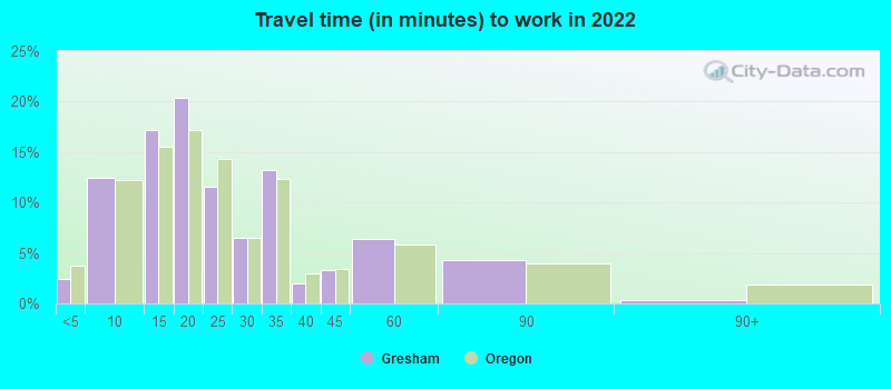
- Mean travel time to work (commute): 24.7 minutes
| Here: | 11.3 |
| Oregon average: | 11.6 |
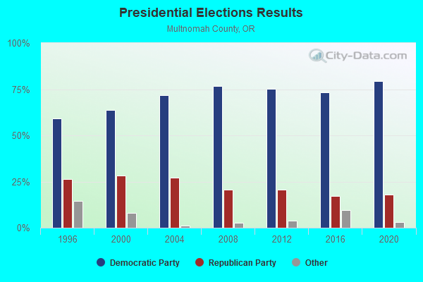
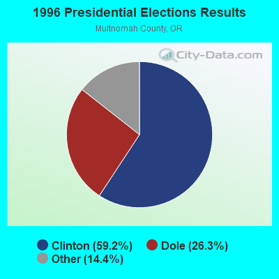
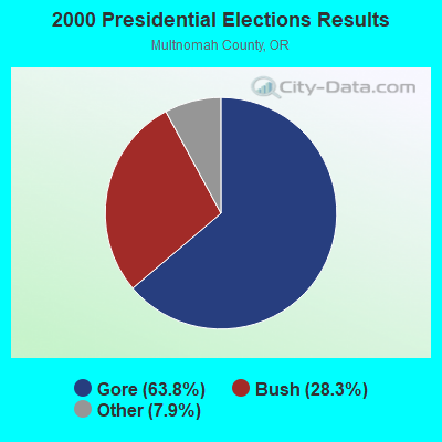
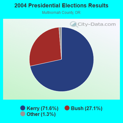
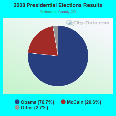
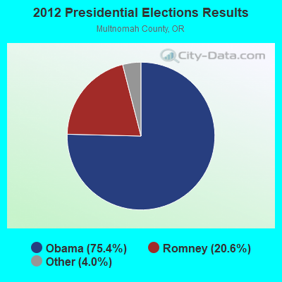
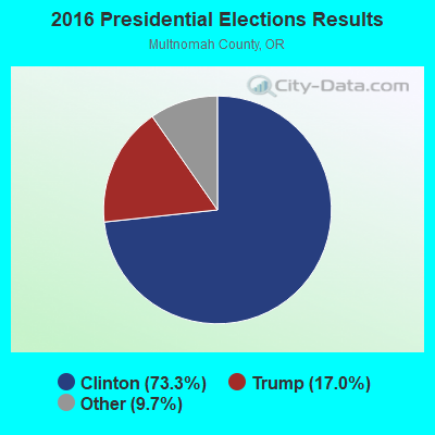
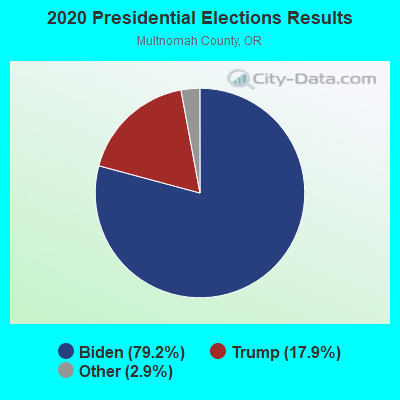
Graphs represent county-level data. Detailed 2008 Election Results
Religion statistics for Gresham, OR (based on Multnomah County data)
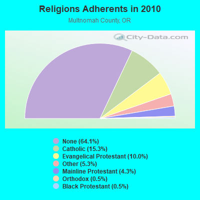
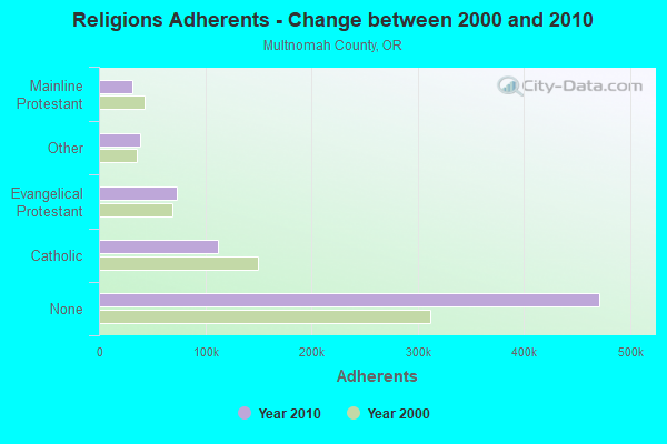
| Religion | Adherents | Congregations |
|---|---|---|
| Catholic | 112,380 | 43 |
| Evangelical Protestant | 73,465 | 313 |
| Other | 39,040 | 110 |
| Mainline Protestant | 31,544 | 127 |
| Orthodox | 3,915 | 11 |
| Black Protestant | 3,590 | 22 |
| None | 471,400 | - |
Food Environment Statistics:
| This county: | 1.74 / 10,000 pop. |
| State: | 2.03 / 10,000 pop. |
| Here: | 0.23 / 10,000 pop. |
| Oregon: | 0.33 / 10,000 pop. |
| Multnomah County: | 2.55 / 10,000 pop. |
| Oregon: | 2.01 / 10,000 pop. |
| Here: | 1.27 / 10,000 pop. |
| Oregon: | 1.69 / 10,000 pop. |
| This county: | 14.29 / 10,000 pop. |
| Oregon: | 9.93 / 10,000 pop. |
| This county: | 7.0% |
| Oregon: | 7.4% |
| This county: | 23.3% |
| Oregon: | 25.6% |
| Multnomah County: | 12.9% |
| Oregon: | 14.2% |
Health and Nutrition:
| This city: | 47.4% |
| State: | 49.6% |
| Gresham: | 44.2% |
| State: | 46.8% |
| Gresham: | 28.3 |
| Oregon: | 28.5 |
| This city: | 22.6% |
| State: | 21.2% |
| This city: | 10.0% |
| State: | 10.1% |
| Gresham: | 6.8 |
| Oregon: | 6.8 |
| Gresham: | 31.6% |
| State: | 33.3% |
| Here: | 55.1% |
| State: | 56.5% |
| This city: | 79.3% |
| Oregon: | 78.7% |
More about Health and Nutrition of Gresham, OR Residents
| Local government employment and payroll (March 2022) | |||||
| Function | Full-time employees | Monthly full-time payroll | Average yearly full-time wage | Part-time employees | Monthly part-time payroll |
|---|---|---|---|---|---|
| Police Protection - Officers | 118 | $1,129,799 | $114,895 | 0 | $0 |
| Firefighters | 112 | $1,034,189 | $110,806 | 0 | $0 |
| Housing and Community Development (Local) | 84 | $592,136 | $84,591 | 1 | $2,700 |
| Financial Administration | 61 | $461,548 | $90,796 | 3 | $12,330 |
| Streets and Highways | 41 | $265,538 | $77,718 | 0 | $0 |
| Other and Unallocable | 35 | $245,119 | $84,041 | 0 | $0 |
| Police - Other | 30 | $195,254 | $78,102 | 0 | $0 |
| Water Supply | 22 | $150,084 | $81,864 | 0 | $0 |
| Natural Resources | 21 | $147,246 | $84,141 | 0 | $0 |
| Sewerage | 20 | $135,623 | $81,374 | 0 | $0 |
| Other Government Administration | 17 | $183,418 | $129,472 | 6 | $19,226 |
| Parks and Recreation | 11 | $57,462 | $62,686 | 0 | $0 |
| Judicial and Legal | 7 | $72,867 | $124,915 | 0 | $0 |
| Fire - Other | 5 | $57,106 | $137,054 | 0 | $0 |
| Solid Waste Management | 4 | $27,831 | $83,493 | 2 | $8,480 |
| Totals for Government | 588 | $4,755,221 | $97,045 | 12 | $42,736 |
Gresham government finances - Expenditure in 2021 (per resident):
- Construction - General - Other: $13,491,000 ($120.86)
Regular Highways: $11,038,000 ($98.89)
Water Utilities: $8,572,000 ($76.80)
Sewerage: $4,898,000 ($43.88)
Housing and Community Development: $1,538,000 ($13.78)
Parks and Recreation: $20,000 ($0.18)
- Current Operations - Police Protection: $28,735,000 ($257.43)
Local Fire Protection: $23,253,000 ($208.32)
Sewerage: $15,560,000 ($139.40)
General - Other: $15,499,000 ($138.85)
Water Utilities: $11,180,000 ($100.16)
Regular Highways: $9,541,000 ($85.48)
Financial Administration: $4,975,000 ($44.57)
Central Staff Services: $4,435,000 ($39.73)
Housing and Community Development: $2,576,000 ($23.08)
General Public Buildings: $2,153,000 ($19.29)
Parks and Recreation: $1,997,000 ($17.89)
Judicial and Legal Services: $1,106,000 ($9.91)
Solid Waste Management: $687,000 ($6.15)
Protective Inspection and Regulation - Other: $492,000 ($4.41)
- General - Interest on Debt: $2,771,000 ($24.83)
- Intergovernmental to Local - Other - Police Protection: $1,793,000 ($16.06)
Other - Local Fire Protection: $1,100,000 ($9.85)
Other - Regular Highways: $155,000 ($1.39)
Other - Central Staff Services: $24,000 ($0.22)
- Intergovernmental to State - Central Staff Services: $67,000 ($0.60)
Financial Administration: $28,000 ($0.25)
Regular Highways: $28,000 ($0.25)
Sewerage: $21,000 ($0.19)
Police Protection: $1,000 ($0.01)
- Other Capital Outlay - Police Protection: $1,913,000 ($17.14)
General - Other: $1,727,000 ($15.47)
Sewerage: $737,000 ($6.60)
Regular Highways: $332,000 ($2.97)
General Public Building: $176,000 ($1.58)
Parks and Recreation: $130,000 ($1.16)
Local Fire Protection: $114,000 ($1.02)
Water Utilities: $46,000 ($0.41)
- Total Salaries and Wages: $57,688,000 ($516.82)
- Water Utilities - Interest on Debt: $388,000 ($3.48)
Gresham government finances - Revenue in 2021 (per resident):
- Charges - Sewerage: $30,617,000 ($274.29)
Other: $5,233,000 ($46.88)
Solid Waste Management: $723,000 ($6.48)
Parks and Recreation: $21,000 ($0.19)
Regular Highways: $3,000 ($0.03)
- Federal Intergovernmental - General Local Government Support: $6,885,000 ($61.68)
Housing and Community Development: $1,957,000 ($17.53)
Highways: $111,000 ($0.99)
Other: $53,000 ($0.47)
- Local Intergovernmental - Other: $32,818,000 ($294.01)
General Local Government Support: $9,608,000 ($86.08)
Highways: $4,360,000 ($39.06)
Housing and Community Development: $237,000 ($2.12)
Water Utilities: $95,000 ($0.85)
- Miscellaneous - Special Assessments: $4,946,000 ($44.31)
Interest Earnings: $4,081,000 ($36.56)
General Revenue - Other: $2,191,000 ($19.63)
Donations From Private Sources: $686,000 ($6.15)
Fines and Forfeits: $433,000 ($3.88)
Sale of Property: $95,000 ($0.85)
Rents: $47,000 ($0.42)
- Revenue - Water Utilities: $16,275,000 ($145.81)
- State Intergovernmental - Highways: $8,352,000 ($74.82)
Other: $4,254,000 ($38.11)
General Local Government Support: $4,169,000 ($37.35)
- Tax - Property: $31,373,000 ($281.07)
Public Utilities Sales: $15,422,000 ($138.16)
Other License: $9,460,000 ($84.75)
Occupation and Business License - Other: $1,048,000 ($9.39)
Other Selective Sales: $748,000 ($6.70)
Alcoholic Beverage License: $10,000 ($0.09)
Amusements License: $8,000 ($0.07)
Gresham government finances - Debt in 2021 (per resident):
- Long Term Debt - Outstanding Unspecified Public Purpose: $87,589,000 ($784.70)
Beginning Outstanding - Unspecified Public Purpose: $85,802,000 ($768.69)
Issue, Unspecified Public Purpose: $12,166,000 ($108.99)
Retired Unspecified Public Purpose: $9,378,000 ($84.02)
Gresham government finances - Cash and Securities in 2021 (per resident):
- Other Funds - Cash and Securities: $248,893,000 ($2229.80)
- Sinking Funds - Cash and Securities: $25,255,000 ($226.26)
8.58% of this county's 2021 resident taxpayers lived in other counties in 2020 ($67,878 average adjusted gross income)
| Here: | 8.58% |
| Oregon average: | 8.20% |
0.01% of residents moved from foreign countries ($71 average AGI)
Multnomah County: 0.01% Oregon average: 0.01%
Top counties from which taxpayers relocated into this county between 2020 and 2021:
| from Washington County, OR | |
| from Clackamas County, OR | |
| from Clark County, WA |
10.03% of this county's 2020 resident taxpayers moved to other counties in 2021 ($87,659 average adjusted gross income)
| Here: | 10.03% |
| Oregon average: | 8.24% |
0.01% of residents moved to foreign countries ($55 average AGI)
Multnomah County: 0.01% Oregon average: 0.00%
Top counties to which taxpayers relocated from this county between 2020 and 2021:
| to Clackamas County, OR | |
| to Washington County, OR | |
| to Clark County, WA |
| Businesses in Gresham, OR | ||||
| Name | Count | Name | Count | |
|---|---|---|---|---|
| 7-Eleven | 2 | MasterBrand Cabinets | 3 | |
| AT&T | 1 | McDonald's | 2 | |
| Ann Taylor | 1 | Men's Wearhouse | 1 | |
| Applebee's | 1 | New Balance | 2 | |
| Arby's | 1 | Nike | 6 | |
| Avenue | 1 | Office Depot | 1 | |
| Baja Fresh Mexican Grill | 1 | Old Navy | 1 | |
| Baskin-Robbins | 1 | Olive Garden | 1 | |
| Bath & Body Works | 1 | Outback | 1 | |
| Bed Bath & Beyond | 1 | Outback Steakhouse | 1 | |
| Best Western | 1 | Pac Sun | 1 | |
| Blockbuster | 1 | Panda Express | 1 | |
| Burger King | 2 | Papa John's Pizza | 1 | |
| Carl\s Jr. | 1 | Payless | 1 | |
| Chico's | 1 | PetSmart | 1 | |
| Cold Stone Creamery | 1 | Pier 1 Imports | 1 | |
| Cricket Wireless | 1 | Pizza Hut | 1 | |
| Curves | 1 | Popeyes | 1 | |
| Dairy Queen | 1 | Quiznos | 2 | |
| Days Inn | 1 | RadioShack | 1 | |
| Discount Tire | 1 | Red Lobster | 1 | |
| Domino's Pizza | 1 | Red Robin | 1 | |
| DressBarn | 1 | Rite Aid | 1 | |
| Dressbarn | 1 | SAS Shoes | 1 | |
| Famous Footwear | 1 | Safeway | 1 | |
| FedEx | 5 | Sprint Nextel | 1 | |
| Firestone Complete Auto Care | 1 | Starbucks | 6 | |
| Ford | 1 | Subaru | 1 | |
| GNC | 1 | Super 8 | 1 | |
| H&R Block | 3 | T-Mobile | 2 | |
| Holiday Inn | 1 | Taco Bell | 2 | |
| Jack In The Box | 2 | The Room Place | 1 | |
| Jones New York | 2 | Toyota | 1 | |
| KFC | 1 | True Value | 1 | |
| Kincaid | 1 | U-Haul | 2 | |
| Kmart | 1 | UPS | 11 | |
| Kroger | 2 | Vans | 2 | |
| LA Fitness | 1 | Verizon Wireless | 2 | |
| La-Z-Boy | 1 | Vons | 2 | |
| Lane Bryant | 1 | Walgreens | 3 | |
| Lane Furniture | 2 | Wendy's | 1 | |
| LensCrafters | 1 | YMCA | 1 | |
| Little Caesars Pizza | 1 | |||
Strongest AM radio stations in Gresham:
- KOTK (1080 AM; 50 kW; PORTLAND, OR; Owner: FISHER BROADCASTING - PORTLAND RADIO, L.L.C.)
- KXL (750 AM; 50 kW; PORTLAND, OR; Owner: ROSE CITY RADIO CORPORATION)
- KGUY (1010 AM; daytime; 4 kW; MILWAUKIE, OR; Owner: NORTHWEST RADIO BROADCASTING COMPANY)
- KPOJ (620 AM; 50 kW; PORTLAND, OR; Owner: CITICASTERS LICENSES, L.P.)
- KEX (1190 AM; 50 kW; PORTLAND, OR; Owner: CITICASTERS LICENSES, L.P.)
- KPAM (860 AM; 50 kW; TROUTDALE, OR; Owner: PAMPLIN BROADCASTING-OREGON, INC.)
- KFXX (910 AM; 10 kW; VANCOUVER, WA; Owner: ENTERCOM PORTLAND LICENSE, LLC (DE))
- KKSN (1520 AM; 50 kW; OREGON CITY, OR; Owner: ENTERCOM PORTLAND LICENSE, LLC)
- KKAD (1550 AM; 50 kW; VANCOUVER, WA; Owner: PAMPLIN BROADCASTING-WASHINGTON, INC)
- KMUZ (1230 AM; 1 kW; GRESHAM, OR; Owner: BUSTOS MEDIA HOLDINGS OF OREGON, LLC)
- KDZR (1640 AM; 10 kW; LAKE OSWEGO, OR; Owner: ABC, INC.)
- KKPZ (1330 AM; 5 kW; PORTLAND, OR; Owner: KPHP RADIO, INC.)
- KKSL (1290 AM; 10 kW; LAKE OSWEGO, OR; Owner: ABC, INC.)
Strongest FM radio stations in Gresham:
- K242AF (96.3 FM; PORTLAND, OR; Owner: EDUCATIONAL MEDIA FOUNDATION)
- K274AR (102.7 FM; GRESHAM, OR; Owner: EDUCATIONAL MEDIA FOUNDATION)
- KNRK (94.7 FM; CAMAS, WA; Owner: ENTERCOM PORTLAND LICENSE, LLC (DE))
- KINK (101.9 FM; PORTLAND, OR; Owner: INFINITY RADIO OPERATIONS INC.)
- KKCW (103.3 FM; BEAVERTON, OR; Owner: CITICASTERS LICENSES, L.P.)
- KFIS (104.1 FM; SCAPPOOSE, OR; Owner: CARON BROADCASTING, INC.)
- KGON (92.3 FM; PORTLAND, OR; Owner: ENTERCOM PORTLAND LICENSE, LLC (DE))
- KKSN-FM (97.1 FM; PORTLAND, OR; Owner: ENTERCOM PORTLAND LICENSE, LLC (DE))
- KXJM (95.5 FM; PORTLAND, OR; Owner: ROSE CITY RADIO CORPORATION)
- KBOO (90.7 FM; PORTLAND, OR; Owner: THE KBOO FOUNDATION)
- KWJJ-FM (99.5 FM; PORTLAND, OR; Owner: FISHER BROADCASTING - PORTLAND RADIO, L.L.C.)
- KOPB-FM (91.5 FM; PORTLAND, OR; Owner: OREGON PUBLIC BROADCASTING)
- KUFO-FM (101.1 FM; PORTLAND, OR; Owner: INFINITY RADIO OPERATIONS INC.)
- KRRC (104.1 FM; PORTLAND, OR; Owner: THE REED INSTITUTE)
- KMHD (89.1 FM; GRESHAM, OR; Owner: MT. HOOD COMMUNITY COLLEGE DISTRICT)
- KVMX (107.5 FM; BANKS, OR; Owner: INFINITY RADIO OPERATIONS INC.)
- KLTH (106.7 FM; LAKE OSWEGO, OR; Owner: INIFINITY RADIO OF PORTLAND INC.)
- KUPL-FM (98.7 FM; PORTLAND, OR; Owner: INFINITY RADIO OF PORTLAND INC.)
- KPDQ-FM (93.7 FM; PORTLAND, OR; Owner: SALEM MEDIA OF OREGON, INC.)
- KKRZ (100.3 FM; PORTLAND, OR; Owner: CITICASTERS LICENSES, L.P.)
TV broadcast stations around Gresham:
- KATU (Channel 2; PORTLAND, OR; Owner: FISHER BROADCASTING - PORTLAND TV, L.L.C.)
- KPDX (Channel 49; VANCOUVER, WA; Owner: MEREDITH CORPORATION)
- KPTV (Channel 12; PORTLAND, OR; Owner: MEREDITH CORPORATION)
- KOIN (Channel 6; PORTLAND, OR; Owner: EMMIS TELEVISION LICENSE CORPORATION)
- KNMT (Channel 24; PORTLAND, OR; Owner: NATIONAL MINORITY T.V., INC.)
- K57IF (Channel 57; SALEM, OR; Owner: LaGRANDE BROADCASTING, INC.)
- KGW (Channel 8; PORTLAND, OR; Owner: KING BROADCASTING COMPANY)
- KOPB-TV (Channel 10; PORTLAND, OR; Owner: OREGON PUBLIC BROADCASTING)
- KPXG-LP (Channel 54; PORTLAND, OR; Owner: PAXSON COMMUNICATIONS LICENSE COMPANY, LLC)
- K14HN (Channel 14; VANCOUVER/CAMAS, WA; Owner: MEREDITH CORPORATION)
- K58CO (Channel 58; PORTLAND, OR; Owner: NORTHWEST CHRISTIAN BROADCASTING)
- KWBP-LP (Channel 4; PORTLAND, OR; Owner: TRIBUNE BROADCASTING HOLDINGS, INC.)
- K16CB (Channel 16; HAPPY VALLEY, OR; Owner: MEREDITH CORPORATION)
- KWBP (Channel 32; SALEM, OR; Owner: TRIBUNE BROADCAST HOLDINGS, INC.)
- KKEI-CA (Channel 56; PORTLAND, OR; Owner: WATCHTV, INC.)
- KPXG (Channel 22; SALEM, OR; Owner: PAXSON SALEM LICENSE, INC.)
- K18EL (Channel 18; NEWBERG/TIGARD, OR; Owner: MEREDITH CORPORATION)
- KORK-CA (Channel 35; PORTLAND, OR; Owner: WATCHTV, INC.)
- National Bridge Inventory (NBI) Statistics
- 13Number of bridges
- 180ft / 54.7mTotal length
- $3,940,000Total costs
- 345,889Total average daily traffic
- 31,324Total average daily truck traffic
- 437,599Total future (year 2025) average daily traffic
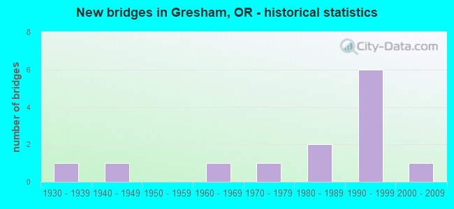
- New bridges - historical statistics
- 11930-1939
- 11940-1949
- 11960-1969
- 11970-1979
- 21980-1989
- 61990-1999
- 12000-2009
FCC Registered Private Land Mobile Towers: 2 (See the full list of FCC Registered Private Land Mobile Towers in Gresham, OR)
FCC Registered Broadcast Land Mobile Towers: 29 (See the full list of FCC Registered Broadcast Land Mobile Towers)
FCC Registered Microwave Towers: 25 (See the full list of FCC Registered Microwave Towers in this town)
FCC Registered Paging Towers: 4 (See the full list of FCC Registered Paging Towers)
FCC Registered Amateur Radio Licenses: 501 (See the full list of FCC Registered Amateur Radio Licenses in Gresham)
FAA Registered Aircraft: 47 (See the full list of FAA Registered Aircraft in Gresham)
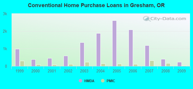
| Home Mortgage Disclosure Act Aggregated Statistics For Year 2009 (Based on 11 full and 8 partial tracts) | ||||||||||||||
| A) FHA, FSA/RHS & VA Home Purchase Loans | B) Conventional Home Purchase Loans | C) Refinancings | D) Home Improvement Loans | E) Loans on Dwellings For 5+ Families | F) Non-occupant Loans on < 5 Family Dwellings (A B C & D) | G) Loans On Manufactured Home Dwelling (A B C & D) | ||||||||
|---|---|---|---|---|---|---|---|---|---|---|---|---|---|---|
| Number | Average Value | Number | Average Value | Number | Average Value | Number | Average Value | Number | Average Value | Number | Average Value | Number | Average Value | |
| LOANS ORIGINATED | 416 | $191,823 | 229 | $169,710 | 1,634 | $186,099 | 62 | $96,436 | 12 | $973,394 | 112 | $152,966 | 10 | $89,882 |
| APPLICATIONS APPROVED, NOT ACCEPTED | 33 | $186,032 | 25 | $160,230 | 227 | $197,483 | 15 | $56,542 | 0 | $0 | 15 | $182,291 | 6 | $33,070 |
| APPLICATIONS DENIED | 80 | $193,519 | 60 | $151,772 | 618 | $204,236 | 45 | $85,388 | 2 | $808,535 | 54 | $157,166 | 13 | $50,744 |
| APPLICATIONS WITHDRAWN | 51 | $189,906 | 46 | $169,741 | 388 | $206,184 | 15 | $88,640 | 1 | $83,440 | 23 | $166,157 | 3 | $95,540 |
| FILES CLOSED FOR INCOMPLETENESS | 5 | $187,082 | 8 | $126,611 | 110 | $190,984 | 14 | $107,774 | 0 | $0 | 3 | $126,380 | 1 | $39,000 |
Detailed mortgage data for all 19 tracts in Gresham, OR
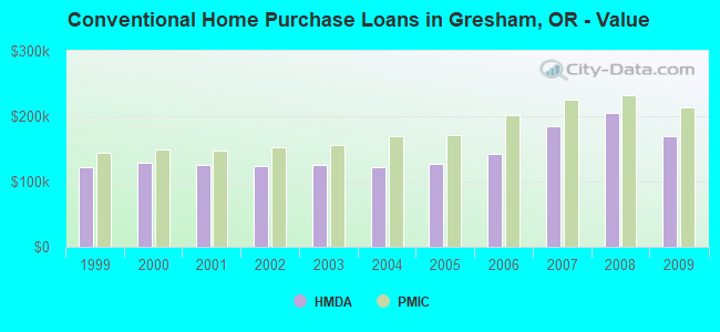
| Private Mortgage Insurance Companies Aggregated Statistics For Year 2009 (Based on 10 full and 8 partial tracts) | ||||||
| A) Conventional Home Purchase Loans | B) Refinancings | C) Non-occupant Loans on < 5 Family Dwellings (A & B) | ||||
|---|---|---|---|---|---|---|
| Number | Average Value | Number | Average Value | Number | Average Value | |
| LOANS ORIGINATED | 31 | $213,554 | 37 | $214,708 | 1 | $136,000 |
| APPLICATIONS APPROVED, NOT ACCEPTED | 18 | $233,261 | 23 | $216,910 | 0 | $0 |
| APPLICATIONS DENIED | 4 | $221,140 | 7 | $183,927 | 0 | $0 |
| APPLICATIONS WITHDRAWN | 4 | $168,500 | 4 | $222,788 | 0 | $0 |
| FILES CLOSED FOR INCOMPLETENESS | 1 | $353,120 | 0 | $0 | 0 | $0 |
2002 - 2018 National Fire Incident Reporting System (NFIRS) incidents
- Fire incident types reported to NFIRS in Gresham, OR
- 2,26052.0%Outside Fires
- 1,16026.7%Structure Fires
- 60614.0%Mobile Property/Vehicle Fires
- 3177.3%Other
 Based on the data from the years 2002 - 2018 the average number of fire incidents per year is 255. The highest number of fires - 394 took place in 2006, and the least - 34 in 2009. The data has a dropping trend.
 When looking into fire subcategories, the most incidents belonged to: Outside Fires (52.0%), and Structure Fires (26.7%).
Fire-safe hotels and motels in Gresham, Oregon:
- Holiday Inn Portland/Gresham, 2752 NE Hogan Dr, Gresham, Oregon 97030 , Phone: (503) 907-1777, Fax: (503) 674-5985
- Canby Inn, 463 SW First Ave, Hwy 99e, Gresham, Oregon 97030 , Phone: (503) 266-5400, Fax: (503) 266-8962
- Howard Johnson Inn, 1572 NE Burnside Rd, Gresham, Oregon 97030 , Phone: (503) 666-9545, Fax: (503) 666-7171
- Quality Inn, 2752 NE Hogan Dr, Gresham, Oregon 97030 , Phone: (503) 907-1777, Fax: (503) 674-5985
- Quality Inn, 2752 NE Hogan Dr, Gresham, Oregon 97030 , Phone: (503) 907-1777, Fax: (503) 674-5985
| Most common first names in Gresham, OR among deceased individuals | ||
| Name | Count | Lived (average) |
|---|---|---|
| John | 245 | 74.3 years |
| William | 215 | 75.2 years |
| Robert | 201 | 71.9 years |
| Mary | 193 | 79.8 years |
| James | 186 | 74.5 years |
| Helen | 139 | 80.4 years |
| Ruth | 131 | 82.3 years |
| George | 128 | 76.4 years |
| Charles | 127 | 76.3 years |
| Dorothy | 120 | 80.5 years |
| Most common last names in Gresham, OR among deceased individuals | ||
| Last name | Count | Lived (average) |
|---|---|---|
| Smith | 128 | 74.7 years |
| Johnson | 120 | 77.7 years |
| Anderson | 89 | 80.7 years |
| Miller | 65 | 78.8 years |
| Nelson | 58 | 77.7 years |
| Jones | 57 | 77.0 years |
| Brown | 53 | 77.0 years |
| Davis | 47 | 71.6 years |
| Williams | 41 | 70.3 years |
| Moore | 40 | 78.8 years |
- 68.5%Utility gas
- 28.4%Electricity
- 1.1%Wood
- 0.9%Fuel oil, kerosene, etc.
- 0.9%Bottled, tank, or LP gas
- 0.2%Other fuel
- 86.4%Electricity
- 12.3%Utility gas
- 0.6%Bottled, tank, or LP gas
- 0.3%No fuel used
- 0.1%Wood
- 0.1%Fuel oil, kerosene, etc.
Gresham compared to Oregon state average:
- Unemployed percentage significantly below state average.
- Black race population percentage above state average.
- Hispanic race population percentage above state average.
- Foreign-born population percentage above state average.
Gresham on our top lists:
- #18 on the list of "Top 101 cities with largest percentage of females in industries: other services, except public administration (population 50,000+)"
- #26 on the list of "Top 101 cities with largest percentage of females in occupations: personal care and service occupations (population 50,000+)"
- #29 on the list of "Top 101 cities with the lowest minimum monthly sunshine amount (population 50,000+)"
- #36 on the list of "Top 101 cities with largest percentage of males in occupations: farming, fishing, and forestry occupations (population 50,000+)"
- #42 on the list of "Top 101 cities with the lowest average sunshine amount (population 50,000+)"
- #43 on the list of "Top 101 cities with the largest city-data.com crime index per police officer (population 50,000+)"
- #48 on the list of "Top 101 cities with the largest city-data.com crime index increase from 2011 to 2012 (population 50,000+)"
- #49 on the list of "Top 101 cities with largest percentage of males in industries: agriculture, forestry, fishing and hunting (population 50,000+)"
- #50 on the list of "Top 101 cities with largest percentage of males in industries: other services, except public administration (population 50,000+)"
- #60 on the list of "Top 101 cities with the highest number of auto thefts per 100,000 residents, excludes tourist destinations and others with a lot of outsiders visiting based on city industries data (population 50,000+)"
- #61 on the list of "Top 101 cities with largest percentage of females in industries: construction (population 50,000+)"
- #67 on the list of "Top 101 cities with largest percentage of males in occupations: building and grounds cleaning and maintenance occupations (population 50,000+)"
- #67 on the list of "Top 101 cities with largest percentage of females in occupations: transportation occupations (population 50,000+)"
- #70 on the list of "Top 101 cities with largest percentage of females in occupations: legal occupations (population 50,000+)"
- #71 on the list of "Top 101 cities with the largest percentage of people in hospices or homes for chronically ill (population 1,000+)"
- #89 on the list of "Top 101 cities with the largest sunshine amount differences during a year (population 50,000+)"
- #91 on the list of "Top 101 cities with largest percentage of males in occupations: material moving occupations (population 50,000+)"
- #94 on the list of "Top 101 larger cities with the largest decrease or smallest increase in household income from 2000 (population 50,000+)"
- #98 on the list of "Top 101 larger cities with the largest decrease or smallest increase in house/condo value from 2000 (population 50,000+)"
- #45 (97236) on the list of "Top 101 zip codes with the largest percentage of Ukrainian first ancestries"
- #13 on the list of "Top 101 counties with the lowest Ozone (1-hour) air pollution readings in 2012 (ppm)"
- #15 on the list of "Top 101 counties with highest percentage of residents voting for 3rd party candidates in the 2012 Presidential Election (pop. 50,000+)"
- #19 on the list of "Top 101 counties with the highest percentage of residents that exercised in the past month"
- #22 on the list of "Top 101 counties with the largest decrease in the number of deaths per 1000 residents 2000-2006 to 2007-2013 (pop. 50,000+)"
- #25 on the list of "Top 101 counties with highest percentage of residents voting for Obama (Democrat) in the 2012 Presidential Election (pop. 50,000+)"

|
|
Total of 150 patent applications in 2008-2024.