Jewell, Oregon
Submit your own pictures of this place and show them to the world
- OSM Map
- General Map
- Google Map
- MSN Map

| Males: 514 | |
| Females: 473 |
| Median resident age: | 44.4 years |
| Oregon median age: | 36.3 years |
Zip code: 97138
| Jewell: | $70,473 |
| OR: | $75,657 |
Estimated per capita income in 2022: $44,096 (it was $22,789 in 2000)
Jewell CCD income, earnings, and wages data
Estimated median house or condo value in 2022: $396,546 (it was $120,100 in 2000)
| Jewell: | $396,546 |
| OR: | $475,600 |
Mean prices in 2022: all housing units: $492,571; detached houses: $524,303; townhouses or other attached units: $497,653; in 2-unit structures: $398,020; in 3-to-4-unit structures: $684,664; in 5-or-more-unit structures: $258,195; mobile homes: $177,599; occupied boats, rvs, vans, etc.: $231,652
Detailed information about poverty and poor residents in Jewell, OR


- 89894.8%White alone
- 283.0%Two or more races
- 111.2%Hispanic
- 50.5%American Indian alone
- 30.3%Asian alone
- 20.2%Black alone

Races in Jewell detailed stats: ancestries, foreign born residents, place of birth
 Recent articles from our blog. Our writers, many of them Ph.D. graduates or candidates, create easy-to-read articles on a wide variety of topics.
Current Local Time: PST time zone
Elevation: 680 feet
Land area: 299.8 square miles.
Population density: 3.3 people per square mile (very low).

| Jewell CCD: | 0.8% ($910) |
| Oregon: | 1.2% ($1,687) |
Nearest city with pop. 50,000+: Hillsboro, OR  (39.3 miles , pop. 70,186).
Nearest city with pop. 200,000+: Portland, OR (51.3 miles , pop. 529,121).
Nearest city with pop. 1,000,000+: Los Angeles, CA (861.1 miles , pop. 3,694,820).
Nearest cities:
), ), Latitude: 45.89 N, Longitude: 123.56 W
Area code: 503


| Here: | 4.0% |
| Oregon: | 3.9% |
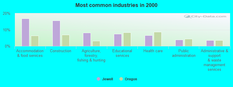
- Accommodation & food services (16.8%)
- Construction (15.7%)
- Agriculture, forestry, fishing & hunting (8.2%)
- Educational services (7.5%)
- Health care (6.5%)
- Public administration (4.0%)
- Administrative & support & waste management services (3.5%)
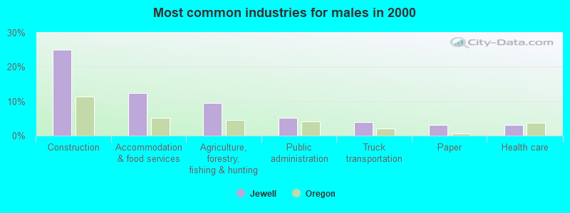
- Construction (25.1%)
- Accommodation & food services (12.4%)
- Agriculture, forestry, fishing & hunting (9.6%)
- Public administration (5.2%)
- Truck transportation (4.0%)
- Paper (3.2%)
- Health care (3.2%)
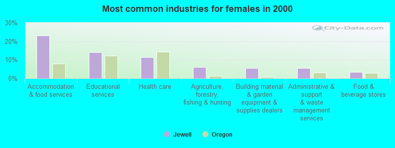
- Accommodation & food services (23.2%)
- Educational services (14.1%)
- Health care (11.3%)
- Agriculture, forestry, fishing & hunting (6.2%)
- Building material & garden equipment & supplies dealers (5.6%)
- Administrative & support & waste management services (5.6%)
- Food & beverage stores (3.4%)

- Other management occupations, except farmers and farm managers (6.1%)
- Carpenters (5.8%)
- Waiters and waitresses (5.8%)
- Cooks and food preparation workers (5.1%)
- Fishing, hunting, and forestry occupations (4.9%)
- Other office and administrative support workers, including supervisors (4.7%)
- Other production occupations, including supervisors (4.2%)

- Carpenters (10.0%)
- Fishing, hunting, and forestry occupations (7.6%)
- Other management occupations, except farmers and farm managers (6.8%)
- Other production occupations, including supervisors (6.4%)
- Driver/sales workers and truck drivers (4.8%)
- Other food preparation and serving workers, including supervisors (4.8%)
- Construction traders workers except carpenters, electricians, painters, plumbers, and construction laborers (4.4%)

- Other office and administrative support workers, including supervisors (9.6%)
- Cooks and food preparation workers (8.5%)
- Waiters and waitresses (8.5%)
- Other sales and related occupations, including supervisors (7.3%)
- Secretaries and administrative assistants (6.8%)
- Other management occupations, except farmers and farm managers (5.1%)
- Preschool, kindergarten, elementary, and middle school teachers (4.5%)
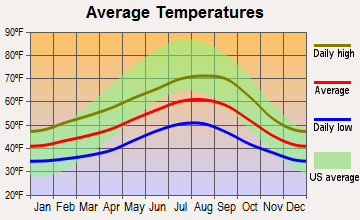
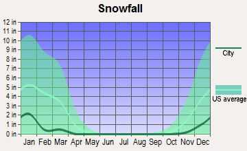
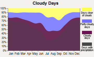
Average climate in Jewell, Oregon
Based on data reported by over 4,000 weather stations


Earthquake activity:
Jewell-area historical earthquake activity is significantly above Oregon state average. It is 1362% greater than the overall U.S. average.On 4/13/1949 at 19:55:42, a magnitude 7.0 (7.0 UK, Class: Major, Intensity: VIII - XII) earthquake occurred 106.6 miles away from the city center, causing $80,000,000 total damage
On 2/28/2001 at 18:54:32, a magnitude 6.8 (6.5 MB, 6.6 MS, 6.8 MW, Class: Strong, Intensity: VII - IX) earthquake occurred 95.1 miles away from Jewell center, causing $2,000,000,000 total damage and $305,000,000 insured losses
On 2/28/2001 at 18:54:32, a magnitude 6.8 (6.8 MD, Depth: 32.2 mi) earthquake occurred 95.5 miles away from Jewell center
On 4/29/1965 at 15:28:43, a magnitude 6.6 (6.6 UK) earthquake occurred 114.5 miles away from the city center, causing $28,000,000 total damage
On 1/31/1922 at 13:17:28, a magnitude 7.6 (7.6 UK) earthquake occurred 372.9 miles away from Jewell center
On 8/17/1991 at 22:17:14, a magnitude 7.1 (6.2 MB, 7.1 MS, 7.1 MW, 6.8 ML, Depth: 8.4 mi) earthquake occurred 304.0 miles away from the city center
Magnitude types: body-wave magnitude (MB), duration magnitude (MD), local magnitude (ML), surface-wave magnitude (MS), moment magnitude (MW)
Natural disasters:
The number of natural disasters in Clatsop County (16) is near the US average (15).Major Disasters (Presidential) Declared: 15
Emergencies Declared: 1
Causes of natural disasters: Floods: 11, Storms: 8, Landslides: 6, Mudslides: 6, Winter Storms: 5, Winds: 2, Heavy Rain: 1, Hurricane: 1, Snow: 1, Other: 1 (Note: some incidents may be assigned to more than one category).
Colleges/universities with over 2000 students nearest to Jewell:
- Pacific University (about 34 miles; Forest Grove, OR; Full-time enrollment: 2,967)
- Lower Columbia College (about 35 miles; Longview, WA; FT enrollment: 2,595)
- University of Portland (about 46 miles; Portland, OR; FT enrollment: 4,030)
- Clark College (about 48 miles; Vancouver, WA; FT enrollment: 9,330)
- George Fox University (about 50 miles; Newberg, OR; FT enrollment: 2,954)
- Concordia University-Portland (about 50 miles; Portland, OR; FT enrollment: 3,996)
- Portland State University (about 50 miles; Portland, OR; FT enrollment: 21,450)
Points of interest:
Notable locations in Jewell: Sterling Forest Station (A), Jewell Junction (B), Fishhawk Lake Recreation Club Wastewater Treatment Facility (C), Camp Olson (D), Camp McGregor (E), Vesper (F), Buster Camp (G), Sunset Safety Rest Area (H), Vesper School (I), Northrup Pit (J), Pope - Meeker Drift Boat Access (K), Doctor Rankins Place (L), Pope Corner (M), Mist - Birkenfeld Rural Fire Protection District Fishhawk Lake Station (N), Elsie - Vinemaple Rural Fire Protection District 11 (O), Mist - Birkenfeld Fire Department Sager (P). Display/hide their locations on the map
Cemeteries: Jewell Cemetery (1), Sunny Hill Cemetery (2). Display/hide their locations on the map
Lakes and reservoirs: Lost Lake (A), Spruce Run Lake (B), Bloom Lake (C), Fishhawk Lake (D). Display/hide their locations on the map
Rivers and creeks: Trailover Creek (A), Sager Creek (B), Boxer Creek (C), Warner Creek (D), Nelson Creek (E), Grub Creek (F), Bear Creek (G), South Fork Rock Creek (H), Beaver Creek (I). Display/hide their locations on the map
Parks in Jewell include: David Douglas County Park (1), Nehalem County Park (2), Saddle Mountain State Park (3), Sunset Highway State Park (4), Howard Rierson Spruce Run County Park (5), Fishhawk Falls - Lee Wooden County Park (6), Jewell Meadows State Wildlife Management Area (7). Display/hide their locations on the map
| This place: | 2.4 people |
| Oregon: | 2.5 people |
| This place: | 65.8% |
| Whole state: | 63.4% |
| This place: | 8.6% |
| Whole state: | 8.0% |
Likely homosexual households (counted as self-reported same-sex unmarried-partner households)
- Lesbian couples: 0.7% of all households
- Gay men: 0.0% of all households
| This place: | 9.4% |
| Whole state: | 11.6% |
| This place: | 5.7% |
| Whole state: | 5.0% |
For population 15 years and over in Jewell:

- Never married: 13.9%
- Now married: 63.0%
- Separated: 0.3%
- Widowed: 7.6%
- Divorced: 15.5%
For population 25 years and over in Jewell:
- High school or higher: 84.5%
- Bachelor's degree or higher: 10.2%
- Graduate or professional degree: 3.8%
- Unemployed: 8.5%
- Mean travel time to work (commute): 38.8 minutes


| Here: | 8.7 |
| Oregon average: | 11.5 |
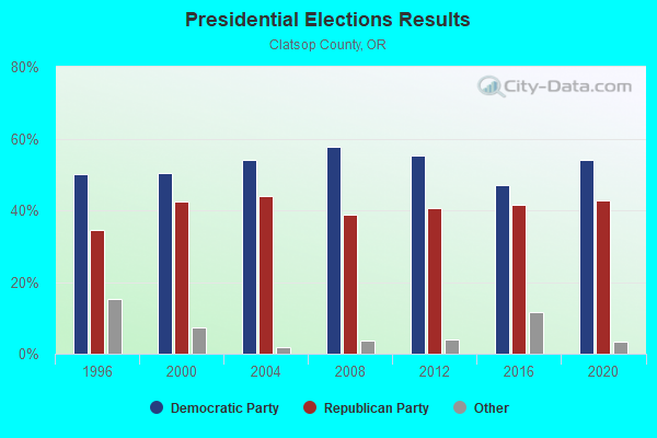
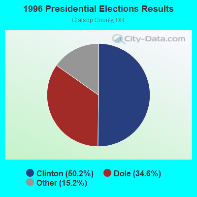
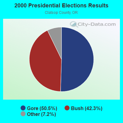
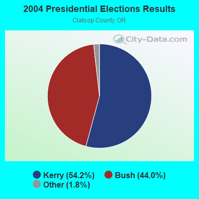

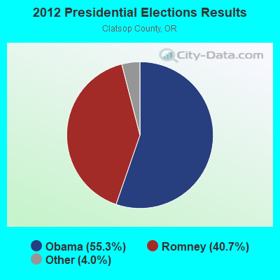
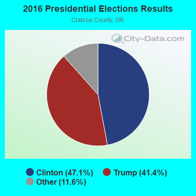
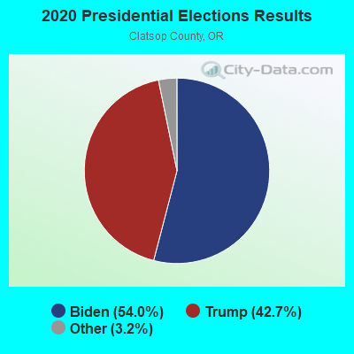
Graphs represent county-level data. Detailed 2008 Election Results
Religion statistics for Jewell, OR (based on Clatsop County data)
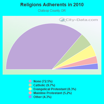
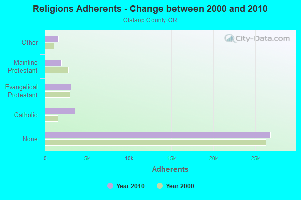
| Religion | Adherents | Congregations |
|---|---|---|
| Catholic | 3,595 | 3 |
| Evangelical Protestant | 3,075 | 31 |
| Mainline Protestant | 1,942 | 13 |
| Other | 1,590 | 9 |
| None | 26,837 | - |
Food Environment Statistics:
| Clatsop County: | 4.02 / 10,000 pop. |
| State: | 2.03 / 10,000 pop. |
| Clatsop County: | 0.54 / 10,000 pop. |
| Oregon: | 0.33 / 10,000 pop. |
| This county: | 1.34 / 10,000 pop. |
| Oregon: | 2.01 / 10,000 pop. |
| This county: | 4.02 / 10,000 pop. |
| Oregon: | 1.69 / 10,000 pop. |
| Here: | 27.88 / 10,000 pop. |
| State: | 9.93 / 10,000 pop. |
| Clatsop County: | 8.9% |
| Oregon: | 7.4% |
| This county: | 24.7% |
| Oregon: | 25.6% |
| Clatsop County: | 6.6% |
| Oregon: | 14.2% |
Strongest AM radio stations in Jewell:
- KPOJ (620 AM; 50 kW; PORTLAND, OR; Owner: CITICASTERS LICENSES, L.P.)
- KPAM (860 AM; 50 kW; TROUTDALE, OR; Owner: PAMPLIN BROADCASTING-OREGON, INC.)
- KXL (750 AM; 50 kW; PORTLAND, OR; Owner: ROSE CITY RADIO CORPORATION)
- KOTK (1080 AM; 50 kW; PORTLAND, OR; Owner: FISHER BROADCASTING - PORTLAND RADIO, L.L.C.)
- KAST (1370 AM; 10 kW; ASTORIA, OR; Owner: NEW NORTHWEST BROADCASTERS, LLC)
- KEX (1190 AM; 50 kW; PORTLAND, OR; Owner: CITICASTERS LICENSES, L.P.)
- KKAD (1550 AM; 50 kW; VANCOUVER, WA; Owner: PAMPLIN BROADCASTING-WASHINGTON, INC)
- KKSN (1520 AM; 50 kW; OREGON CITY, OR; Owner: ENTERCOM PORTLAND LICENSE, LLC)
- KIRO (710 AM; 50 kW; SEATTLE, WA; Owner: ENTERCOM SEATTLE LICENSE, LLC)
- KTTH (770 AM; 50 kW; SEATTLE, WA; Owner: ENTERCOM SEATTLE LICENSE, LLC)
- KJR (950 AM; 50 kW; SEATTLE, WA)
- KGNW (820 AM; 50 kW; BURIEN-SEATTLE, WA; Owner: INSPIRATION MEDIA, INC.)
- KSWB (840 AM; 1 kW; SEASIDE, OR; Owner: CANNON BEACH RADIO)
Strongest FM radio stations in Jewell:
- K216DH (91.1 FM; CATHLAMET, WA; Owner: TILLICUM FOUNDATION)
- KCBZ (94.9 FM; CANNON BEACH, OR; Owner: ENTERCOM PORTLAND LICENSE, LLC)
- K289AC (105.7 FM; NEDONNA BEACH, OR; Owner: OREGON PUBLIC BROADCASTING)
- K273AI (102.5 FM; ARIEL, WA; Owner: CALVARY CHAPEL OF TWIN FALLS, INC.)
- K228DT (93.5 FM; HAPPY HOLLOW, OR; Owner: OREGON PUBLIC BROADCASTING)
- KMUN (91.9 FM; ASTORIA, OR; Owner: TILLICUM FOUNDATION)
- KWYA (89.7 FM; ASTORIA, OR; Owner: WAY-FM MEDIA GROUP, INC.)
- KRQT (107.1 FM; CASTLE ROCK, WA; Owner: ENTERCOM LONGVIEW LICENSE, LLC)
- KMNT (102.9 FM; CENTRALIA, WA; Owner: CITICASTERS LICENSES, L.P.)
- KTIL-FM (94.1 FM; TILLAMOOK, OR; Owner: OREGON EAGLE, INC.)
- KDEP (105.5 FM; DEPOE BAY, OR; Owner: ALEXANDRA COMMUNICATIONS, INC.)
- KINK (101.9 FM; PORTLAND, OR; Owner: INFINITY RADIO OPERATIONS INC.)
- KKCW (103.3 FM; BEAVERTON, OR; Owner: CITICASTERS LICENSES, L.P.)
- KRVO (105.9 FM; VANCOUVER, WA; Owner: CITICASTERS LICENSES, L.P.)
- KPDQ-FM (93.7 FM; PORTLAND, OR; Owner: SALEM MEDIA OF OREGON, INC.)
- KOPB-FM (91.5 FM; PORTLAND, OR; Owner: OREGON PUBLIC BROADCASTING)
- KKRZ (100.3 FM; PORTLAND, OR; Owner: CITICASTERS LICENSES, L.P.)
- KAST-FM (92.9 FM; ASTORIA, OR; Owner: NEW NORTHWEST BROADCASTERS, LLC)
- KMHD (89.1 FM; GRESHAM, OR; Owner: MT. HOOD COMMUNITY COLLEGE DISTRICT)
- KVMX (107.5 FM; BANKS, OR; Owner: INFINITY RADIO OPERATIONS INC.)
FCC Registered Broadcast Land Mobile Towers:
2- Fish & Wildlife Hdqtrs Jewell Meadows Recreation Area (Lat: 45.940667 Lon: -123.527083), Structure height: 7 m, Call Sign: WPAF800, Licensee ID: L00458641,
Assigned Frequencies: 0.53000 MHz, Grant Date: 07/13/2022, Expiration Date: 08/06/2032, Registrant: State Of Oregon, 79878 Highway 202, Seaside, OR 97138, Phone: (503) 755-2264, Fax: (503) 755-0706, Email:
- Jewell Meadows 1.5 Mi Nw (Lat: 45.940389 Lon: -123.526806), Type: Pole, Structure height: 8 m, Overall height: 9 m, Call Sign: KFK329,
Assigned Frequencies: 151.220 MHz, 151.490 MHz, 151.190 MHz, 151.460 MHz, Grant Date: 05/27/2015, Expiration Date: 08/23/2025, Registrant: Reg 4 Fcca, 1104 1st Street, Steilacoom, WA 98388, Phone: (253) 831-3017, Fax: (503) 945-7320, Email:
FCC Registered Microwave Towers:
1- JEWELL, Hwy 202 (Lat: 45.933722 Lon: -123.512333), Overall height: 53 m, Call Sign: WPJE774,
Assigned Frequencies: 10715.0 MHz, Grant Date: 03/08/2011, Expiration Date: 02/01/2021, Cancellation Date: 12/19/2011, Registrant: Centurytel, Inc., 805 Broadway Suite 800, Vancouver, WA 98660, Phone: (360) 905-6839, Fax: (360) 905-5953, Email:

- 44.6%Wood
- 30.7%Electricity
- 13.6%Bottled, tank, or LP gas
- 7.0%Fuel oil, kerosene, etc.
- 2.4%Other fuel
- 1.7%Utility gas

- 57.3%Wood
- 29.1%Electricity
- 9.7%Bottled, tank, or LP gas
- 3.9%Fuel oil, kerosene, etc.
Jewell compared to Oregon state average:
- Unemployed percentage below state average.
- Black race population percentage significantly below state average.
- Hispanic race population percentage significantly below state average.
- Median age above state average.
- Foreign-born population percentage significantly below state average.
- Renting percentage below state average.
- Length of stay since moving in significantly above state average.
- Number of rooms per house significantly below state average.
- House age significantly below state average.
- Number of college students below state average.
- Percentage of population with a bachelor's degree or higher significantly below state average.