Middleburg, Kentucky
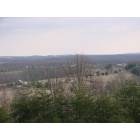
Middleburg: view from High Ridge Rd, Middleburg
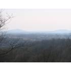
Middleburg: view from High Ridge Rd, Middleburg
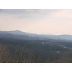
Middleburg: view from High Ridge Rd, Middleburg
- add
your
Submit your own pictures of this place and show them to the world
- OSM Map
- General Map
- Google Map
- MSN Map

| Males: 1,653 | |
| Females: 1,677 |
| Median resident age: | 37.6 years |
| Kentucky median age: | 35.9 years |
Zip code: 42566
| Middleburg: | $42,837 |
| KY: | $59,341 |
Estimated per capita income in 2022: $26,780 (it was $14,796 in 2000)
Middleburg CCD income, earnings, and wages data
Estimated median house or condo value in 2022: $129,144 (it was $43,000 in 2000)
| Middleburg: | $129,144 |
| KY: | $196,300 |
Mean prices in 2022: all housing units: $145,827; detached houses: $175,931; townhouses or other attached units: $75,954; mobile homes: $51,373
Detailed information about poverty and poor residents in Middleburg, KY
Compare current foreclosures near Middleburg, KY:
| Photo | Address | Area | Beds / Baths | Price | Details |
|---|---|---|---|---|---|

|
#1
Ky 906
Hustonville, KY 40437
|
1,719 sq. feet
|
2 baths 4 beds |
show details | |

|
#2
Floyd Switch Rd
Eubank, KY 42567
|
2,488 sq. feet
|
2 baths 3 beds |
show details | |

|
#3
Little South Rd
Gravel Switch, KY 40328
|
1,628 sq. feet
|
1 baths 3 beds |
show details | |

|
#4
Hall Ridge Rd
Science Hill, KY 42553
|
1,568 sq. feet
|
2 baths 3 beds |
show details | |

|
#5
Jess Gill Rd
Somerset, KY 42503
|
1,280 sq. feet
|
2 baths 3 beds |
show details | |

|
#6
Anita Ln
Somerset, KY 42503
|
624 sq. feet
|
1 baths 2 beds |
show details | |

|
#7
Lower Brush Creek Rd
Liberty, KY 42539
|
1,892 sq. feet
|
2 baths 2 beds |
show details | |

|
#8
Floyd Switch Estesburg Rd
Eubank, KY 42567
|
1,616 sq. feet
|
2 baths 3 beds |
show details | |

|
#9
Mercy Way
Science Hill, KY 42553
|
1,316 sq. feet
|
2 baths 3 beds |
show details | |

|
#10
Wilson Ridge Rd
Science Hill, KY 42553
|
720 sq. feet
|
2 baths 5 beds |
show details |
| Photo | Address | Area | Beds / Baths | Price | Details |
|---|---|---|---|---|---|

|
#11
Ky Highway 39 S
Crab Orchard, KY 40419
|
1,024 sq. feet
|
1 baths 2 beds |
show details | |

|
#12
Ky 1547
Liberty, KY 42539
|
2,476 sq. feet
|
4 baths 3 beds |
show details | |

|
#13
Highway 1676
Science Hill, KY 42553
|
1,320 sq. feet
|
2 baths 3 beds |
show details | |

|
#14
Stanford St
Science Hill, KY 42553
|
1,194 sq. feet
|
1 baths 3 beds |
show details | |

|
#15
Carmicle St
Liberty, KY 42539
|
1,016 sq. feet
|
2 baths 3 beds |
show details | |

|
#16
Tanglewood Dr
Science Hill, KY 42553
|
1,746 sq. feet
|
2 baths 3 beds |
show details | |

|
#17
E Ky 70
Liberty, KY 42539
|
1,168 sq. feet
|
1 baths 2 beds |
show details | |

|
#18
W Highway 80
Somerset, KY 42503
|
1,824 sq. feet
|
2 baths 3 beds |
show details | |

|
#19
Bethlehem Ridge Rd
Science Hill, KY 42553
|
1,344 sq. feet
|
1 baths 3 beds |
show details | |

|
#20
Ringgold Rd
Somerset, KY 42503
|
2,001 sq. feet
|
2 baths 4 beds |
show details |
| Photo | Address | Area | Beds / Baths | Price | Details |
|---|---|---|---|---|---|

|
#21
Heaton Ford Rd
Science Hill, KY 42553
|
1,092 sq. feet
|
2 baths 2 beds |
show details | |

|
#22
Highway 39
Somerset, KY 42503
|
2,164 sq. feet
|
2 baths 3 beds |
show details | |

|
#23
Raintree Cir
Stanford, KY 40484
|
- sq. feet
|
2 baths 3 beds |
show details | |

|
#24
Northridge Rd
Stanford, KY 40484
|
- sq. feet
|
2 baths 3 beds |
show details | |

|
#25
Ky Highway 643
Waynesburg, KY 40489
|
- sq. feet
|
1 baths 3 beds |
show details | |

|
#26
Sunset Blvd
Hustonville, KY 40437
|
- sq. feet
|
1 baths 2 beds |
show details | |

|
#27
Us Highway 27 S
Stanford, KY 40484
|
- sq. feet
|
1 baths 3 beds |
show details | |

|
#28
Raintree Dr
Stanford, KY 40484
|
- sq. feet
|
2 baths 3 beds |
show details | |

|
#29
Carter School Rd
Stanford, KY 40484
|
718 sq. feet
|
- baths 2 beds |
show details | |

|
#30
Ky Highway 1247
Waynesburg, KY 40489
|
- sq. feet
|
2 baths 3 beds |
show details |
| Photo | Address | Area | Beds / Baths | Price | Details |
|---|---|---|---|---|---|

|
#31
Andy Spencer Rd
Eubank, KY 42567
|
- sq. feet
|
2 baths 3 beds |
show details | |

|
#32
Ky Highway 70 W
Eubank, KY 42567
|
- sq. feet
|
2 baths 3 beds |
show details | |

|
#33
Pleasant Point School Rd
Waynesburg, KY 40489
|
- sq. feet
|
1 baths 2 beds |
show details | |

|
#34
Ky Highway 3248
Stanford, KY 40484
|
- sq. feet
|
2 baths 3 beds |
show details | |

|
#35
Lancaster St
Stanford, KY 40484
|
- sq. feet
|
1 baths 3 beds |
show details | |

|
#36
Somerset St
Stanford, KY 40484
|
- sq. feet
|
1 baths 2 beds |
show details | |

|
#37
Ringgold Rd
Somerset, KY 42503
|
- sq. feet
|
- baths - beds |
show details | |

|
#38
Scotts Chapel Rd
Liberty, KY 42539
|
1,764 sq. feet
|
- baths - beds |
show details | |

|
#39
W Highway 80
Nancy, KY 42544
|
- sq. feet
|
- baths - beds |
show details | |

|
#40
Dotson Dr # 8
Hustonville, KY 40437
|
- sq. feet
|
- baths - beds |
show details |
| Photo | Address | Area | Beds / Baths | Price | Details |
|---|---|---|---|---|---|

|
#41
Hillside Ct
Somerset, KY 42503
|
- sq. feet
|
- baths - beds |
show details | |

|
#42
N Highway 1247, Unit 2
Science Hill, KY 42553
|
- sq. feet
|
- baths - beds |
show details | |

|
#43
L Stringer Rd
Somerset, KY 42503
|
- sq. feet
|
- baths - beds |
show details | |

|
#44
Boneyville Rd
Stanford, KY 40484
|
- sq. feet
|
- baths - beds |
show details | |

|
#45
Foxden Ln
Stanford, KY 40484
|
- sq. feet
|
- baths - beds |
show details | |

|
#46
Maywood Rd
Stanford, KY 40484
|
- sq. feet
|
- baths - beds |
show details | |

|
#47
N Old Stilesville Rd
Eubank, KY 42567
|
- sq. feet
|
- baths - beds |
show details | |

|
#48
Riffe Creek Rd
Dunnville, KY 42528
|
- sq. feet
|
- baths - beds |
show details | |

|
#49
Country Hill Dr
Somerset, KY 42503
|
- sq. feet
|
- baths - beds |
show details | |

|
Check over 1 million property listings on Foreclosure.com!
|
browse all offers | |||

- 3,08997.6%White alone
- 461.5%Hispanic
- 180.6%Two or more races
- 50.2%Black alone
- 50.2%American Indian alone
- 10.03%Asian alone

Races in Middleburg detailed stats: ancestries, foreign born residents, place of birth
 Recent articles from our blog. Our writers, many of them Ph.D. graduates or candidates, create easy-to-read articles on a wide variety of topics.
Current Local Time: EST time zone
Elevation: 840 feet
Land area: 84.0 square miles.
Population density: 40 people per square mile (very low).

| Middleburg CCD: | 0.5% ($225) |
| Kentucky: | 0.8% ($610) |
Nearest city with pop. 50,000+: Fayette, KY  (51.7 miles , pop. 260,512).
Nearest city with pop. 1,000,000+: Chicago, IL (348.6 miles , pop. 2,896,016).
Nearest cities:
), ), )Latitude: 37.32 N, Longitude: 84.79 W
Area code commonly used in this area: 606


| Here: | 3.8% |
| Kentucky: | 3.8% |

- Apparel (9.1%)
- Construction (8.4%)
- Educational services (7.5%)
- Health care (6.9%)
- Agriculture, forestry, fishing & hunting (6.4%)
- Repair & maintenance (4.2%)
- Food & beverage stores (4.0%)

- Construction (15.2%)
- Agriculture, forestry, fishing & hunting (12.4%)
- Repair & maintenance (8.1%)
- Machinery (6.2%)
- Metal & metal products (5.4%)
- Truck transportation (5.2%)
- Apparel (4.4%)

- Apparel (14.2%)
- Health care (13.1%)
- Educational services (10.9%)
- Food & beverage stores (6.4%)
- Accommodation & food services (6.2%)
- Personal & laundry services (4.5%)
- Miscellaneous manufacturing (3.6%)

- Textile, apparel, and furnishings workers (7.8%)
- Metal workers and plastic workers (7.2%)
- Driver/sales workers and truck drivers (6.7%)
- Other production occupations, including supervisors (5.8%)
- Laborers and material movers, hand (5.5%)
- Farmers and farm managers (4.3%)
- Assemblers and fabricators (3.6%)

- Metal workers and plastic workers (11.0%)
- Driver/sales workers and truck drivers (10.9%)
- Farmers and farm managers (8.2%)
- Laborers and material movers, hand (7.8%)
- Other production occupations, including supervisors (6.0%)
- Vehicle and mobile equipment mechanics, installers, and repairers (4.8%)
- Other material moving workers, except laborers (4.4%)

- Textile, apparel, and furnishings workers (15.7%)
- Cashiers (6.0%)
- Other production occupations, including supervisors (5.5%)
- Nursing, psychiatric, and home health aides (4.5%)
- Information and record clerks, except customer service representatives (4.4%)
- Assemblers and fabricators (4.2%)
- Cooks and food preparation workers (4.1%)
Average climate in Middleburg, Kentucky
Based on data reported by over 4,000 weather stations


(lower is better)

Air Quality Index (AQI) level in 2022 was 62.9. This is about average.
| City: | 62.9 |
| U.S.: | 72.6 |

Ozone [ppb] level in 2022 was 28.6. This is about average. Closest monitor was 18.2 miles away from the city center.
| City: | 28.6 |
| U.S.: | 33.3 |

Particulate Matter (PM2.5) [µg/m3] level in 2022 was 7.87. This is about average. Closest monitor was 18.2 miles away from the city center.
| City: | 7.87 |
| U.S.: | 8.11 |
Tornado activity:
Middleburg-area historical tornado activity is near Kentucky state average. It is 25% greater than the overall U.S. average.
On 4/27/1971, a category F4 (max. wind speeds 207-260 mph) tornado 17.4 miles away from the Middleburg place center killed 2 people and injured 72 people and caused between $500,000 and $5,000,000 in damages.
On 4/3/1974, a category F4 tornado 21.4 miles away from the place center injured 56 people and caused between $500,000 and $5,000,000 in damages.
Earthquake activity:
Middleburg-area historical earthquake activity is significantly above Kentucky state average. It is 95% greater than the overall U.S. average.On 7/27/1980 at 18:52:21, a magnitude 5.2 (5.1 MB, 4.7 MS, 5.0 UK, 5.2 UK, Class: Moderate, Intensity: VI - VII) earthquake occurred 76.8 miles away from Middleburg center
On 4/18/2008 at 09:36:59, a magnitude 5.4 (5.1 MB, 4.8 MS, 5.4 MW, 5.2 MW) earthquake occurred 186.3 miles away from the city center
On 4/18/2008 at 09:36:59, a magnitude 5.2 (5.2 MW, Depth: 8.9 mi) earthquake occurred 186.3 miles away from the city center
On 9/7/1988 at 02:28:09, a magnitude 4.6 (4.5 MB, 4.6 LG, Class: Light, Intensity: IV - V) earthquake occurred 75.7 miles away from the city center
On 6/18/2002 at 17:37:15, a magnitude 5.0 (4.3 MB, 4.6 MW, 5.0 LG) earthquake occurred 170.2 miles away from the city center
On 11/30/1973 at 07:48:41, a magnitude 4.7 (4.7 MB, 4.6 ML) earthquake occurred 114.8 miles away from the city center
Magnitude types: regional Lg-wave magnitude (LG), body-wave magnitude (MB), local magnitude (ML), surface-wave magnitude (MS), moment magnitude (MW)
Natural disasters:
The number of natural disasters in Casey County (23) is greater than the US average (15).Major Disasters (Presidential) Declared: 18
Emergencies Declared: 3
Causes of natural disasters: Floods: 14, Storms: 13, Tornadoes: 7, Winter Storms: 6, Mudslides: 4, Winds: 3, Landslides: 2, Blizzard: 1, Freeze: 1, Hurricane: 1, Snow: 1, Snowfall: 1, Snowstorm: 1, Other: 1 (Note: some incidents may be assigned to more than one category).
Colleges/universities with over 2000 students nearest to Middleburg:
- Somerset Community College (about 21 miles; Somerset, KY; Full-time enrollment: 4,698)
- Campbellsville University (about 31 miles; Campbellsville, KY; FT enrollment: 2,948)
- Lindsey Wilson College (about 32 miles; Columbia, KY; FT enrollment: 2,552)
- Eastern Kentucky University (about 40 miles; Richmond, KY; FT enrollment: 13,525)
- Bluegrass Community and Technical College (about 52 miles; Lexington, KY; FT enrollment: 8,560)
- University of Kentucky (about 52 miles; Lexington, KY; FT enrollment: 23,517)
- University of the Cumberlands (about 54 miles; Williamsburg, KY; FT enrollment: 3,585)
Points of interest:
Notable locations in Middleburg: Wa-kon-da-ho Camp (A), Kidds Store (B), Southeast Casey County Volunteer Fire Department (C), East Casey Volunteer Fire Department (D). Display/hide their locations on the map
Churches in Middleburg include: Watson Chapel Christian Church (A), Green River Christian Church (B), Grove Church (C), Grove Ridge Baptist Church (D), Indian Creek Baptist Church (E), Mount Calvary Baptist Church (F), Rich Hill Church (G), Walltown Christian Church (H). Display/hide their locations on the map
Cemeteries: Brown Cemetery (1), Hatter Cemetery (2), Durham Cemetery (3), Dunham Cemetery (4), Wall Cemetery (5), Falconbury Cemetery (6), Watson Chapel Cemetery (7). Display/hide their locations on the map
Streams, rivers, and creeks: Britches Leg Branch (A), Crane Creek (B), Trough Lick (C), Tilford Creek (D), Carpenter Creek (E), Pine Lick Creek (F), McCann Branch (G), Polston Branch (H), Long Branch (I). Display/hide their locations on the map
| This place: | 2.5 people |
| Kentucky: | 2.5 people |
| This place: | 70.1% |
| Whole state: | 66.9% |
| This place: | 6.3% |
| Whole state: | 6.4% |
Likely homosexual households (counted as self-reported same-sex unmarried-partner households)
- Lesbian couples: 0.2% of all households
- Gay men: 0.3% of all households
| This place: | 18.2% |
| Whole state: | 15.8% |
| This place: | 4.8% |
| Whole state: | 6.6% |
Banks with branches in Middleburg (2011 data):
- Farmers Deposit Bank of Middleburg, Inc.: Farmers Deposit Bank Of Middleburg, Inc. at 2959 Shorttown Road, branch established on 1904/01/01. Info updated 2010/03/26: Bank assets: $47.0 mil, Deposits: $37.8 mil, local headquarters, negative income in the last year, Commercial Lending Specialization, 2 total offices, Holding Company: John R Turner Holding Company
For population 15 years and over in Middleburg:

- Never married: 17.4%
- Now married: 65.1%
- Separated: 2.2%
- Widowed: 8.6%
- Divorced: 8.9%
For population 25 years and over in Middleburg:
- High school or higher: 61.3%
- Bachelor's degree or higher: 4.9%
- Graduate or professional degree: 2.0%
- Unemployed: 4.3%
- Mean travel time to work (commute): 33.6 minutes


| Here: | 14.0 |
| Kentucky average: | 13.8 |
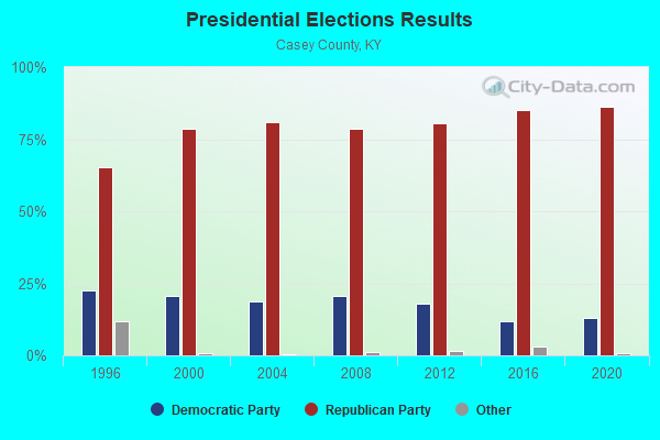
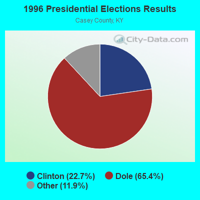
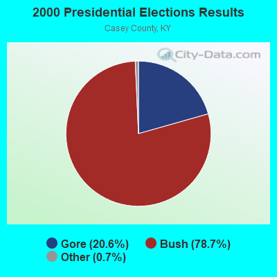
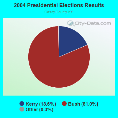
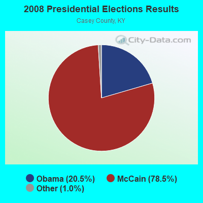
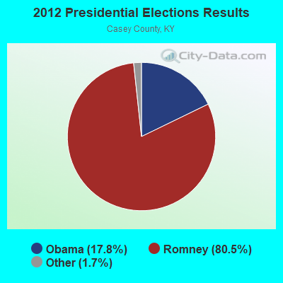
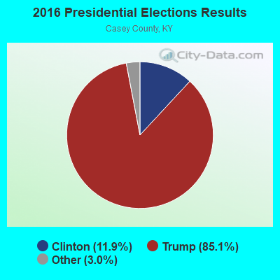

Graphs represent county-level data. Detailed 2008 Election Results
Religion statistics for Middleburg, KY (based on Casey County data)
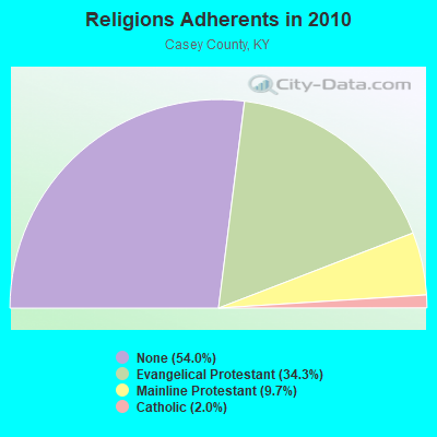
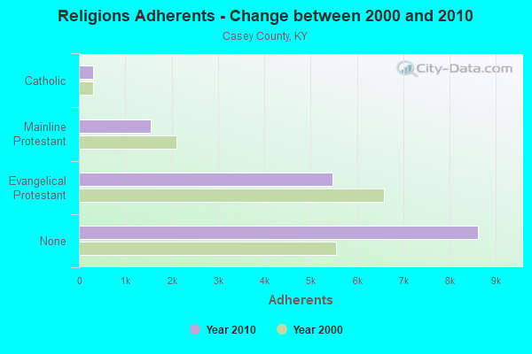
| Religion | Adherents | Congregations |
|---|---|---|
| Evangelical Protestant | 5,470 | 46 |
| Mainline Protestant | 1,554 | 13 |
| Catholic | 312 | 2 |
| Other | 2 | - |
| None | 8,617 | - |
Food Environment Statistics:
| This county: | 4.34 / 10,000 pop. |
| Kentucky: | 2.19 / 10,000 pop. |
| Casey County: | 2.48 / 10,000 pop. |
| Kentucky: | 0.74 / 10,000 pop. |
| Casey County: | 6.82 / 10,000 pop. |
| Kentucky: | 4.36 / 10,000 pop. |
| This county: | 3.72 / 10,000 pop. |
| Kentucky: | 5.74 / 10,000 pop. |
| Casey County: | 12.7% |
| Kentucky: | 11.0% |
| Casey County: | 31.2% |
| Kentucky: | 30.0% |
| Casey County: | 15.1% |
| Kentucky: | 15.9% |
Strongest AM radio stations in Middleburg:
- WKDO (1560 AM; daytime; 1 kW; LIBERTY, KY; Owner: CARLOS WESLEY)
- WHAS (840 AM; 50 kW; LOUISVILLE, KY; Owner: CLEAR CHANNEL BROADCASTING LICENSES, INC.)
- WKVL (850 AM; daytime; 50 kW; KNOXVILLE, TN; Owner: HORNE RADIO, LLC)
- WSM (650 AM; 50 kW; NASHVILLE, TN; Owner: GAYLORD ENTERTAINMENT COMPANY)
- WLW (700 AM; 50 kW; CINCINNATI, OH; Owner: JACOR BROADCASTING CORPORATION)
- WVLK (590 AM; 5 kW; LEXINGTON, KY; Owner: CUMULUS LICENSING CORP.)
- WAMB (1160 AM; 50 kW; DONELSON, TN; Owner: GREAT SOUTHERN BROADCASTING COMPANY, INC.)
- WDFB (1170 AM; daytime; 1 kW; JUNCTION CITY, KY; Owner: ALUM SPRINGS VISION & OUTREACH CORP)
- WSAI (1530 AM; 50 kW; CINCINNATI, OH; Owner: JACOR BROADCASTING CORPORATION)
- WWAM (820 AM; daytime; 50 kW; JASPER, TN; Owner: SHELTON BROADCASTING SYSTEM)
- WSFC (1240 AM; 1 kW; SOMERSET, KY; Owner: CAPSTAR TX LIMITED PARTNERSHIP)
- WTVN (610 AM; 50 kW; COLUMBUS, OH; Owner: CITICASTERS LICENSES, L.P.)
- WKDA (1200 AM; 50 kW; NASHVILLE, TN; Owner: RADIO NASHVILLE, INC.)
Strongest FM radio stations in Middleburg:
- WXKY-FM (96.3 FM; STANFORD, KY; Owner: LINCOLN-GARRARD BROADCASTING CO.,INC)
- WKDO-FM (98.7 FM; LIBERTY, KY; Owner: CARLOS D. WESLEY)
- WSEK (97.1 FM; SOMERSET, KY; Owner: CAPSTAR TX LIMITED PARTNERSHIP)
- WTHL (90.5 FM; SOMERSET, KY; Owner: SOMERSET EDUCATIONAL BROADCASTING FOUNDATION)
- WDCL-FM (89.7 FM; SOMERSET, KY; Owner: WESTERN KENTUCKY UNIVERSITY)
- WLLK (93.9 FM; BURNSIDE, KY; Owner: CAPSTAR TX LIMITED PARTNERSHIP)
- WKII-FM (102.3 FM; SOMERSET, KY; Owner: CAPSTAR TX LIMITED PARTNERSHIP)
- W277AA (103.3 FM; SOMERSET, KY; Owner: WESTERN KENTUCKY UNIVERSITY)
- WDFB-FM (88.1 FM; DANVILLE, KY; Owner: ALUM SPRINGS EDUCATIONAL CORPORATION)
- WVLC (99.9 FM; MANNSVILLE, KY; Owner: PATRICIA RODGERS)
- WMKZ (93.1 FM; MONTICELLO, KY; Owner: MONTICELLO-WAYNE COUNTY MEDIA, INC.)
- WYGE (92.3 FM; LONDON, KY; Owner: ETHEL HUFF BROADCASTING, LLC)
- WLFX (106.7 FM; BEREA, KY; Owner: WALLINGFORD COMMUNICATIONS, LLC)
- WRNZ (105.1 FM; LANCASTER, KY; Owner: HOMETOWN BROADCASTING OF LANCASTER, INC.)
- WJRS (104.9 FM; JAMESTOWN, KY; Owner: LAKE CUMBERLAND BROADCASTERS)
TV broadcast stations around Middleburg:
- WKSO-TV (Channel 29; SOMERSET, KY; Owner: KENTUCKY AUTHORITY FOR EDUCATIONAL TV)
- WDKY-TV (Channel 56; DANVILLE, KY; Owner: WDKY LICENSEE, LLC)
- WBKI-TV (Channel 34; CAMPBELLSVILLE, KY; Owner: LOUISVILLE COMMUNICATIONS, LLC)

- 54.0%Electricity
- 23.3%Wood
- 10.9%Bottled, tank, or LP gas
- 9.4%Fuel oil, kerosene, etc.
- 2.4%Utility gas

- 43.0%Wood
- 29.0%Electricity
- 23.7%Bottled, tank, or LP gas
- 4.3%Fuel oil, kerosene, etc.
Middleburg compared to Kentucky state average:
- Median house value below state average.
- Unemployed percentage significantly below state average.
- Black race population percentage significantly below state average.
- Hispanic race population percentage below state average.
- Foreign-born population percentage significantly below state average.
- Renting percentage below state average.
- Length of stay since moving in significantly above state average.
- Number of rooms per house significantly below state average.
- House age significantly below state average.
- Number of college students significantly below state average.
- Percentage of population with a bachelor's degree or higher significantly below state average.