Papaikou-Wailea, Hawaii
Submit your own pictures of this place and show them to the world
- OSM Map
- Google Map
- MSN Map
| Males: 2,803 | |
| Females: 2,959 |
| Median resident age: | 42.5 years |
| Hawaii median age: | 36.2 years |
Zip code: 96783
| Papaikou-Wailea: | $66,359 |
| HI: | $92,458 |
Estimated per capita income in 2022: $34,297 (it was $17,102 in 2000)
Papaikou-Wailea CCD income, earnings, and wages data
Estimated median house or condo value in 2022: $482,178 (it was $139,900 in 2000)
| Papaikou-Wailea: | $482,178 |
| HI: | $820,100 |
Mean prices in 2022: all housing units: $595,903; detached houses: $598,158; townhouses or other attached units: $648,474; in 2-unit structures: over $1,000,000; in 3-to-4-unit structures: $549,649; in 5-or-more-unit structures: $517,976; mobile homes: $220,909; occupied boats, rvs, vans, etc.: $401,772
Papaikou-Wailea, HI residents, houses, and apartments details
Detailed information about poverty and poor residents in Papaikou-Wailea, HI
Compare current foreclosures near your location:
| Photo | Address | Area | Beds / Baths | Price | Details |
|---|---|---|---|---|---|

|
#1
N Rhodes St
Pretty Prairie, KS 67570
|
1,725 sq. feet
|
2 baths 4 beds |
show details | |

|
#2
W 21st St N
Cheney, KS 67025
|
3,190 sq. feet
|
3 baths 5 beds |
show details | |

|
#3
NE Waterloo Ave
Murdock, KS 67111
|
1,220 sq. feet
|
1 baths 3 beds |
show details | |

|
#4
E Arlington Rd
Haven, KS 67543
|
960 sq. feet
|
1 baths 2 beds |
show details | |

|
#5
S Daily Rd
Mount Hope, KS 67108
|
1,828 sq. feet
|
2 baths 2 beds |
show details | |

|
#6
E Winterset St
Goddard, KS 67052
|
816 sq. feet
|
1 baths 2 beds |
show details | |

|
#7
W 39th St S
Goddard, KS 67052
|
4,221 sq. feet
|
3 baths 3 beds |
show details | |

|
#8
E 4th Ave Apt 1
Cheney, KS 67025
|
- sq. feet
|
- baths - beds |
show details | |

|
#9
SE Viney Ave
Murdock, KS 67111
|
- sq. feet
|
- baths - beds |
show details | |

|
#10
W Main St
Mount Hope, KS 67108
|
- sq. feet
|
- baths - beds |
show details |
| Photo | Address | Area | Beds / Baths | Price | Details |
|---|---|---|---|---|---|

|
#11
N 189th Cir W
Colwich, KS 67030
|
- sq. feet
|
- baths - beds |
show details | |

|
#12
N Main St
Goddard, KS 67052
|
- sq. feet
|
- baths - beds |
show details | |

|
#13
Martens Ct
Goddard, KS 67052
|
- sq. feet
|
- baths - beds |
show details | |

|
#14
W Maple St Lot D
Goddard, KS 67052
|
- sq. feet
|
- baths - beds |
show details | |

|
#15
S 339th St W
Cheney, KS 67025
|
- sq. feet
|
- baths - beds |
show details | |

|
#16
E Casey Dr
Goddard, KS 67052
|
- sq. feet
|
- baths - beds |
show details | |

|
Check over 1 million property listings on Foreclosure.com!
|
browse all offers | |||

- 2,16143.6%Asian alone
- 1,11022.4%Two or more races
- 94719.1%White alone
- 4068.2%Hispanic
- 2925.9%Native Hawaiian and Other
Pacific Islander alone - 220.4%American Indian alone
- 130.3%Black alone
- 100.2%Other race alone

Races in Papaikou-Wailea detailed stats: ancestries, foreign born residents, place of birth
 Recent articles from our blog. Our writers, many of them Ph.D. graduates or candidates, create easy-to-read articles on a wide variety of topics.
Current Local Time: HST (no DST) time zone
Land area: 96.0 square miles.
Population density: 60 people per square mile (very low).
| Papaikou-Wailea CCD: | 0.2% ($259) |
| Hawaii: | 0.3% ($765) |
Nearest city with pop. 50,000+: Honolulu, HI  (202.7 miles , pop. 371,657).
Nearest city with pop. 1,000,000+: Los Angeles, CA (2453.4 miles , pop. 3,694,820).
Nearest cities:
), ), ), ), ), Latitude: 19.83 N, Longitude: 155.12 W
Area code commonly used in this area: 808

| Here: | 2.6% |
| Hawaii: | 2.9% |

- Agriculture, forestry, fishing & hunting (12.1%)
- Health care (10.0%)
- Educational services (9.8%)
- Accommodation & food services (8.7%)
- Public administration (6.9%)
- Construction (4.2%)
- Administrative & support & waste management services (3.9%)

- Agriculture, forestry, fishing & hunting (16.6%)
- Construction (8.1%)
- Accommodation & food services (7.8%)
- Educational services (6.6%)
- Public administration (6.5%)
- Health care (6.3%)
- Administrative & support & waste management services (4.3%)

- Health care (13.7%)
- Educational services (13.0%)
- Accommodation & food services (9.5%)
- Agriculture, forestry, fishing & hunting (7.5%)
- Public administration (7.3%)
- Food & beverage stores (4.4%)
- Department & other general merchandise stores (3.7%)

- Agricultural workers, including supervisors (6.4%)
- Building and grounds cleaning and maintenance occupations (6.1%)
- Other sales and related occupations, including supervisors (4.9%)
- Farmers and farm managers (4.6%)
- Other office and administrative support workers, including supervisors (4.3%)
- Retail sales workers, except cashiers (3.6%)
- Information and record clerks, except customer service representatives (2.7%)

- Agricultural workers, including supervisors (9.0%)
- Farmers and farm managers (6.2%)
- Other sales and related occupations, including supervisors (6.1%)
- Building and grounds cleaning and maintenance occupations (4.9%)
- Vehicle and mobile equipment mechanics, installers, and repairers (3.0%)
- Cooks and food preparation workers (3.0%)
- Top executives (2.9%)

- Other office and administrative support workers, including supervisors (8.5%)
- Building and grounds cleaning and maintenance occupations (7.3%)
- Information and record clerks, except customer service representatives (5.1%)
- Retail sales workers, except cashiers (5.1%)
- Cashiers (4.8%)
- Secretaries and administrative assistants (3.8%)
- Other sales and related occupations, including supervisors (3.8%)
Average climate in Papaikou-Wailea, Hawaii
Based on data reported by over 4,000 weather stations


(lower is better)

Air Quality Index (AQI) level in 2022 was 36.5. This is significantly better than average.
| City: | 36.5 |
| U.S.: | 72.6 |

Sulfur Dioxide (SO2) [ppb] level in 2022 was 0.362. This is significantly better than average. Closest monitor was 8.0 miles away from the city center.
| City: | 0.362 |
| U.S.: | 1.515 |

Particulate Matter (PM2.5) [µg/m3] level in 2022 was 3.45. This is significantly better than average. Closest monitor was 8.0 miles away from the city center.
| City: | 3.45 |
| U.S.: | 8.11 |
Earthquake activity:
Papaikou-Wailea-area historical earthquake activity is significantly above Hawaii state average. It is 2571% greater than the overall U.S. average.On 11/29/1975 at 14:47:40, a magnitude 7.2 (6.0 MB, 7.1 MS, 7.2 UK, 7.2 MS, Class: Major, Intensity: VIII - XII) earthquake occurred 27.0 miles away from the city center, causing 2 deaths (2 shaking deaths)
On 5/4/2018 at 22:32:54, a magnitude 6.9 (6.9 MW, Depth: 3.6 mi, Class: Strong, Intensity: VII - IX) earthquake occurred 36.5 miles away from Papaikou-Wailea center
On 8/21/1951 at 10:57:00, a magnitude 6.9 (6.9 UK) earthquake occurred 57.4 miles away from the city center
On 11/16/1983 at 16:13:00, a magnitude 6.7 (6.4 MB, 6.7 MS, 6.7 MW) earthquake occurred 31.9 miles away from Papaikou-Wailea center, causing $6,000,000 total damage
On 10/15/2006 at 17:07:49, a magnitude 6.7 (6.7 MD, Depth: 23.7 mi) earthquake occurred 53.0 miles away from the city center
On 10/15/2006 at 17:07:49, a magnitude 6.7 (6.2 MB, 6.6 MS, 6.7 MW) earthquake occurred 56.5 miles away from the city center
Magnitude types: body-wave magnitude (MB), duration magnitude (MD), surface-wave magnitude (MS), moment magnitude (MW)
Natural disasters:
The number of natural disasters in Hawaii County (21) is greater than the US average (15).Major Disasters (Presidential) Declared: 11
Causes of natural disasters: Fires: 7, Earthquakes: 4, Floods: 3, Storms: 3, Volcanic Eruptions: 3, Hurricanes: 2, Lava Flows: 2, High Surf: 1, Mudslide: 1, Tropical Storm: 1, Tsunami Wave: 1, Other: 1 (Note: some incidents may be assigned to more than one category).
Hospitals and medical centers near Papaikou-Wailea:
- HILO DIALYSIS (Dialysis Facility, about 8 miles away; HILO, HI)
- HALE ANUENUE RESTORATIVE CARE (Nursing Home, about 8 miles away; HILO, HI)
- HILO MEDICAL CENTER HOME CARE (Home Health Center, about 8 miles away; HILO, HI)
- HILO MEDICAL CENTER Acute Care Hospitals (about 8 miles away; HILO, HI)
- HILO HOSPITAL - ICF/DP (Nursing Home, about 8 miles away; HILO, HI)
- YUKIO OKUTSU STATE VETERANS HOME (Nursing Home, about 8 miles away; HILO, HI)
- HOSPICE OF HILO (Hospital, about 8 miles away; HILO, HI)
Colleges/universities with over 2000 students nearest to Papaikou-Wailea:
- University of Hawaii at Hilo (about 10 miles; Hilo, HI; Full-time enrollment: 3,161)
- Hawaii Community College (about 10 miles; Hilo, HI; FT enrollment: 2,137)
- University of Hawaii Maui College (about 115 miles; Kahului, HI; FT enrollment: 2,492)
- Kapiolani Community College (about 200 miles; Honolulu, HI; FT enrollment: 5,069)
- Chaminade University of Honolulu (about 202 miles; Honolulu, HI; FT enrollment: 2,610)
- University of Hawaii at Manoa (about 202 miles; Honolulu, HI; FT enrollment: 16,461)
- Hawaii Pacific University (about 205 miles; Honolulu, HI; FT enrollment: 5,506)
Points of interest:
Notable locations in Papaikou-Wailea: Maukaloa Camp (A), Andrade Camp (B), Kahuā Ranch (C), Pepeekeo Volunteer Fire Station 01A (D). Display/hide their locations on the map
Churches in Papaikou-Wailea include: Good Shepherd Roman Catholic Church (A), Honomu Hongwanji Church (B). Display/hide their locations on the map
Cemetery: Mauna Kea Memorial Park (1). Display/hide its location on the map
Streams, rivers, and creeks: Wai‘a‘ama Stream (A), Kawainui Stream (B), Pōhakupa‘a Stream (C), Pāhoehoe Stream (D), Puuokalepa Stream (E), Mākea Stream (F), Kapue Stream (G), Kaapoko Stream (H), Waiko‘ana Stream (I). Display/hide their locations on the map
Parks in Papaikou-Wailea include: Kolekole Beach Park (1), ‘Akaka Falls State Park (2). Display/hide their locations on the map
| This place: | 2.7 people |
| Hawaii: | 2.9 people |
| This place: | 69.8% |
| Whole state: | 68.9% |
| This place: | 7.8% |
| Whole state: | 7.3% |
Likely homosexual households (counted as self-reported same-sex unmarried-partner households)
- Lesbian couples: 0.3% of all households
- Gay men: 0.3% of all households
| This place: | 15.7% |
| Whole state: | 10.7% |
| This place: | 6.1% |
| Whole state: | 5.0% |
People in group quarters in Papaikou-Wailea in 2010:
- 8 people in group homes intended for adults
- 4 people in nursing facilities/skilled-nursing facilities
- 2 people in workers' group living quarters and job corps centers
For population 15 years and over in Papaikou-Wailea:

- Never married: 28.9%
- Now married: 54.3%
- Separated: 1.5%
- Widowed: 9.2%
- Divorced: 7.6%
For population 25 years and over in Papaikou-Wailea:
- High school or higher: 73.5%
- Bachelor's degree or higher: 15.0%
- Graduate or professional degree: 5.3%
- Unemployed: 8.2%
- Mean travel time to work (commute): 23.7 minutes


| Here: | 14.9 |
| Hawaii average: | 12.8 |
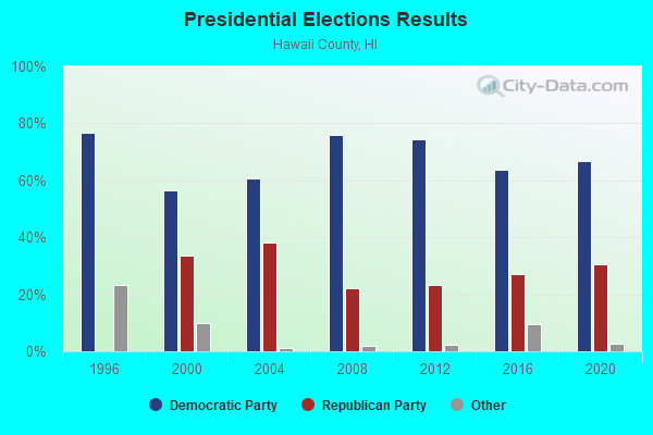
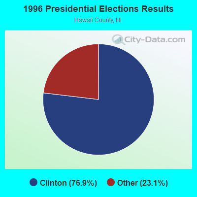
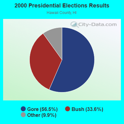
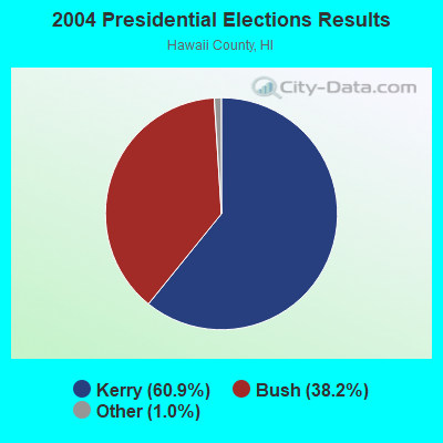

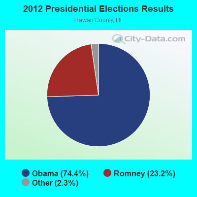
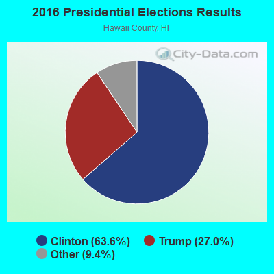
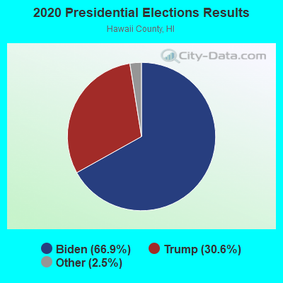
Graphs represent county-level data. Detailed 2008 Election Results
Religion statistics for Papaikou-Wailea, HI (based on Hawaii County data)
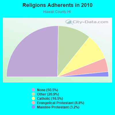
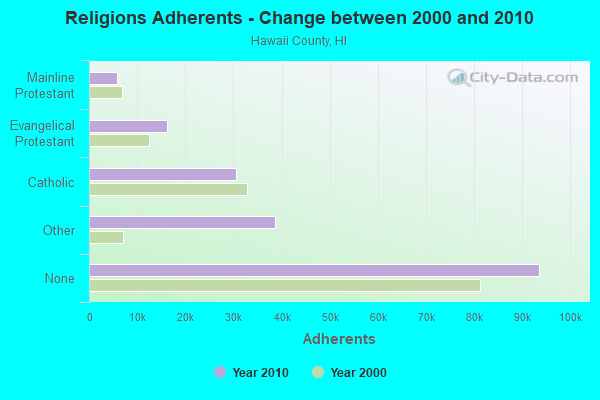
| Religion | Adherents | Congregations |
|---|---|---|
| Other | 38,701 | 88 |
| Catholic | 30,616 | 22 |
| Evangelical Protestant | 16,302 | 120 |
| Mainline Protestant | 5,882 | 43 |
| Orthodox | 25 | 1 |
| None | 93,553 | - |
Food Environment Statistics:
| Hawaii County: | 2.09 / 10,000 pop. |
| Hawaii: | 2.30 / 10,000 pop. |
| Hawaii County: | 0.06 / 10,000 pop. |
| State: | 0.09 / 10,000 pop. |
| Hawaii County: | 1.97 / 10,000 pop. |
| Hawaii: | 1.57 / 10,000 pop. |
| This county: | 2.55 / 10,000 pop. |
| Hawaii: | 1.72 / 10,000 pop. |
| Hawaii County: | 8.29 / 10,000 pop. |
| State: | 9.00 / 10,000 pop. |
| Hawaii County: | 7.1% |
| State: | 8.1% |
| Here: | 21.2% |
| State: | 20.8% |
| Hawaii County: | 10.3% |
| Hawaii: | 9.2% |
5.92% of this county's 2021 resident taxpayers lived in other counties in 2020 ($88,163 average adjusted gross income)
| Here: | 5.92% |
| Hawaii average: | 4.91% |
0.03% of residents moved from foreign countries ($348 average AGI)
Hawaii County: 0.03% Hawaii average: 0.19%
Top counties from which taxpayers relocated into this county between 2020 and 2021:
| from Honolulu County, HI | |
| from Maui County, HI | |
| from Los Angeles County, CA |
4.50% of this county's 2020 resident taxpayers moved to other counties in 2021 ($58,837 average adjusted gross income)
| Here: | 4.50% |
| Hawaii average: | 5.53% |
0.03% of residents moved to foreign countries ($272 average AGI)
Hawaii County: 0.03% Hawaii average: 0.15%
Top counties to which taxpayers relocated from this county between 2020 and 2021:
| to Honolulu County, HI | |
| to Clark County, NV | |
| to Maui County, HI |
Strongest AM radio stations in Papaikou-Wailea:
- KIPA (620 AM; 10 kW; NAALEHU, HI; Owner: BIG ISLAND RADIO)
- KPUA (670 AM; 10 kW; HILO, HI; Owner: NEW WEST BROADCASTING CORP.)
- KHLO (850 AM; 5 kW; HILO, HI; Owner: MAVERICK MEDIA OF HAWAII LICENSE, LLC)
- KHBC (1060 AM; 5 kW; HILO, HI; Owner: HILO BROADCASTING, L.L.C.)
- KUAU (1570 AM; 50 kW; HAIKU, HI; Owner: FIRST ASSEMBLY OF GOD-KAHULUI, MAUI)
- KAIM (870 AM; 50 kW; HONOLULU, HI; Owner: SALEM MEDIA OF HAWAII, INC.)
- KKON (790 AM; 5 kW; KEALAKEKUA, HI; Owner: BIG ISLAND RADIO ( HAWAII LIMITED PA)
- KMVI (550 AM; 5 kW; WAILUKU, HI; Owner: PACIFIC RADIO GROUP,INC.)
- KNUI (900 AM; 5 kW; KAHULUI, HI; Owner: PACIFIC RADIO GROUP, INC.)
- KAOI (1110 AM; 5 kW; KIHEI, HI; Owner: VISIONARY RELATED ENTERTAINMENT, INC)
- KORL (690 AM; 10 kW; HONOLULU, HI; Owner: NEW WAVE BROADCASTING, L.P.)
- KGU (760 AM; 10 kW; HONOLULU, HI; Owner: SALEM MEDIA OF HAWAII, INC.)
- KHNR (650 AM; 10 kW; HONOLULU, HI; Owner: SALEM MEDIA OF HAWAII, INC.)
Strongest FM radio stations in Papaikou-Wailea:
- KNUQ (103.7 FM; PAAUILO, HI; Owner: VISIONARY RELATED ENTERTAINMENT II,)
- KAGB (99.1 FM; WAIMEA, HI; Owner: BIG ISLAND RADIO)
- KLUA (93.9 FM; KAILUA KONA, HI; Owner: BIG ISLAND RADIO)
- KLEO (106.1 FM; KAHALUU, HI; Owner: MAVERICK MEDIA OF HAWAII LICENSE, LLC)
- KAOY (101.5 FM; KEALAKEKUA, HI; Owner: BIG ISLAND RADIO ( HAWAII LIMITED PA)
- KKUA (90.7 FM; WAILUKU, HI; Owner: HAWAII PUBLIC RADIO, INC.)
- KCIF (90.3 FM; HILO, HI; Owner: HILO CHRISTIAN BROADCASTING CORP.)
- KAPA (100.3 FM; HILO, HI; Owner: BIG ISLAND RADIO)
- KWYI (106.9 FM; KAWAIHAE, HI; Owner: COLIN H. NAITO)
- KHWI (92.7 FM; HILO, HI; Owner: BIG ISLAND RADIO)
- KNWB (97.1 FM; HILO, HI; Owner: NEW WEST BROADCASTING CORP.)
- KWXX-FM (94.7 FM; HILO, HI; Owner: NEW WEST BROADCASTING CORP.)
- KANO (91.1 FM; HILO, HI; Owner: HAWAII PUBLIC RADIO)
- K220EO (91.9 FM; HILO, HI; Owner: THE MOODY BIBLE INSTITUTE OF CHICAGO)
- KPVS (95.9 FM; HILO, HI; Owner: BIG ISLAND RADIO)
TV broadcast stations around Papaikou-Wailea:
- KGMD-TV (Channel 9; HILO, HI; Owner: EMMIS TELEVISION LICENSE CORPORATION)
- KWHH (Channel 14; HILO, HI; Owner: LESEA BROADCASTING CORPORATION)
- KHAW-TV (Channel 11; HILO, HI; Owner: EMMIS TELEVISION LICENSE CORPORATION)
- KHBC-TV (Channel 2; HILO, HI; Owner: RAYCOM NATIONAL, INC.)
- KHVO (Channel 13; HILO, HI; Owner: KITV HEARST-ARGYLE TV, INC. (CA CORP.))
- K45CT (Channel 45; HILO, HI; Owner: RAYCOM NATIONAL, INC.)
- K67BA (Channel 67; HAKALAU, HI; Owner: HAWAII PUBLIC TELEVISION FOUNDATION)

- 44.8%No fuel used
- 42.0%Electricity
- 10.6%Bottled, tank, or LP gas
- 1.5%Solar energy
- 0.7%Wood
- 0.5%Utility gas

- 51.1%No fuel used
- 40.7%Electricity
- 7.5%Bottled, tank, or LP gas
- 0.4%Solar energy
- 0.2%Other fuel
Papaikou-Wailea compared to Hawaii state average:
- Median house value below state average.
- Unemployed percentage below state average.
- Black race population percentage significantly below state average.
- Foreign-born population percentage significantly below state average.
- Length of stay since moving in significantly above state average.
- Number of rooms per house significantly below state average.
- House age significantly below state average.
- Percentage of population with a bachelor's degree or higher below state average.
Papaikou-Wailea on our top lists:
- #2 on the list of "Top 101 cities with largest percentage of males in industries: farm product raw materials merchant wholesalers (population 5,000+)"
- #3 on the list of "Top 101 cities with largest percentage of females in industries: farm product raw materials merchant wholesalers (population 5,000+)"
- #6 on the list of "Top 101 cities with largest percentage of males in industries: book stores and news dealers (population 5,000+)"
- #7 on the list of "Top 101 cities with largest percentage of males in occupations: other transportation workers (population 5,000+)"
- #8 on the list of "Top 101 cities with largest percentage of females in occupations: farmers and farm managers (population 5,000+)"
- #15 on the list of "Top 101 larger cities with the lowest real estate taxes percentage (population 50,000+)"
- #24 on the list of "Top 101 cities with largest percentage of males in occupations: agricultural workers including supervisors (population 5,000+)"
- #24 on the list of "Top 101 cities with largest percentage of males in occupations: farmers and farm managers (population 5,000+)"
- #26 on the list of "Top 101 cities with largest percentage of females in occupations: agricultural workers including supervisors (population 5,000+)"
- #28 on the list of "Top 101 cities with largest percentage of males in occupations: registered nurses (population 5,000+)"
- #40 on the list of "Top 101 cities with largest percentage of males in industries: farm supplies merchant wholesalers (population 5,000+)"
- #47 on the list of "Top 101 cities with largest percentage of females in industries: food (population 5,000+)"
- #50 on the list of "Top 101 cities with largest percentage of females in industries: sewing, needlework, and piece goods stores (population 5,000+)"
- #63 on the list of "Top 101 cities with largest percentage of males in industries: religious, grantmaking, civic, professional, and similar organizations (population 5,000+)"
- #67 on the list of "Top 101 cities with largest percentage of females in industries: repair and maintenance (population 5,000+)"
- #70 on the list of "Top 101 cities with largest percentage of males in industries: recyclable material merchant wholesalers (population 5,000+)"
- #84 on the list of "Top 101 cities with largest percentage of females in industries: other transportation, and support activities, and couriers (population 5,000+)"
- #84 on the list of "Top 101 cities with the most people carpooling to work (population 5,000+)"
- #91 on the list of "Top 101 cities with largest percentage of females in industries: agriculture, forestry, fishing and hunting (population 5,000+)"
- #93 on the list of "Top 101 cities with largest percentage of males in industries: social assistance (population 5,000+)"
- #68 (96783) on the list of "Top 101 zip codes with the largest percentage of Portuguese first ancestries"
- #1 on the list of "Top 101 counties with the highest Sulfur Oxides Annual air pollution readings in 2012 (µg/m3)"
- #27 on the list of "Top 101 counties with the lowest average weight of females"
- #50 on the list of "Top 101 counties with the highest percentage of residents that exercised in the past month"
- #59 on the list of "Top 101 counties with highest percentage of residents voting for Obama (Democrat) in the 2012 Presidential Election"
- #61 on the list of "Top 101 counties with the most Other congregations (pop. 50,000+)"