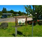
Southwest Benton, Oregon
Submit your own pictures of this place and show them to the world
- OSM Map
- General Map
- Google Map
- MSN Map

| Males: 1,683 | |
| Females: 1,770 |
| Median resident age: | 41.9 years |
| Oregon median age: | 36.3 years |
Zip code: 97324
| Southwest Benton: | $77,426 |
| OR: | $75,657 |
Estimated per capita income in 2022: $34,590 (it was $19,278 in 2000)
Southwest Benton CCD income, earnings, and wages data
Estimated median house or condo value in 2022: $521,951 (it was $166,900 in 2000)
| Southwest Benton: | $521,951 |
| OR: | $475,600 |
Mean prices in 2022: all housing units: $527,422; detached houses: $564,307; townhouses or other attached units: $409,548; in 2-unit structures: $301,079; in 3-to-4-unit structures: $485,522; in 5-or-more-unit structures: $256,840; mobile homes: $179,405; occupied boats, rvs, vans, etc.: $76,136
Southwest Benton, OR residents, houses, and apartments details
Detailed information about poverty and poor residents in Southwest Benton, OR


- 3,14695.0%White alone
- 641.9%Hispanic
- 421.3%Two or more races
- 230.7%American Indian alone
- 220.7%Asian alone
- 60.2%Other race alone
- 40.1%Native Hawaiian and Other
Pacific Islander alone - 30.09%Black alone

Races in Southwest Benton detailed stats: ancestries, foreign born residents, place of birth
 Recent articles from our blog. Our writers, many of them Ph.D. graduates or candidates, create easy-to-read articles on a wide variety of topics.
Current Local Time: PST time zone
Land area: 242.9 square miles.
Population density: 14 people per square mile (very low).

| Southwest Benton CCD: | 0.8% ($1,291) |
| Oregon: | 1.2% ($1,687) |
Nearest city with pop. 50,000+: Eugene, OR  (33.2 miles , pop. 137,893).
Nearest city with pop. 200,000+: Northwest Clackamas, OR (81.9 miles , pop. 224,220).
Nearest city with pop. 1,000,000+: Los Angeles, CA (766.1 miles , pop. 3,694,820).
Nearest cities:
)Latitude: 44.42 N, Longitude: 123.56 W
Area code commonly used in this area: 541


| Here: | 3.1% |
| Oregon: | 3.9% |

- Educational services (12.6%)
- Agriculture, forestry, fishing & hunting (11.2%)
- Construction (10.4%)
- Health care (7.9%)
- Computer & electronic products (5.7%)
- Professional, scientific, technical services (5.6%)
- Accommodation & food services (3.8%)

- Agriculture, forestry, fishing & hunting (15.5%)
- Construction (14.4%)
- Educational services (10.8%)
- Computer & electronic products (7.1%)
- Professional, scientific, technical services (4.7%)
- Wood products (4.2%)
- Repair & maintenance (3.8%)

- Health care (15.8%)
- Educational services (14.6%)
- Professional, scientific, technical services (6.6%)
- Agriculture, forestry, fishing & hunting (6.1%)
- Construction (5.7%)
- Accommodation & food services (4.9%)
- Other transportation, support activities, couriers (4.1%)

- Other management occupations, except farmers and farm managers (7.8%)
- Computer specialists (4.1%)
- Other production occupations, including supervisors (3.9%)
- Preschool, kindergarten, elementary, and middle school teachers (3.5%)
- Fishing, hunting, and forestry occupations (3.5%)
- Bookkeeping, accounting, and auditing clerks (3.3%)
- Electrical equipment mechanics and other installation, maintenance, and repair workers, including supervisors (3.1%)

- Other management occupations, except farmers and farm managers (6.8%)
- Fishing, hunting, and forestry occupations (6.5%)
- Other production occupations, including supervisors (6.5%)
- Electrical equipment mechanics and other installation, maintenance, and repair workers, including supervisors (5.7%)
- Vehicle and mobile equipment mechanics, installers, and repairers (5.4%)
- Driver/sales workers and truck drivers (5.0%)
- Computer specialists (3.9%)

- Other management occupations, except farmers and farm managers (8.9%)
- Bookkeeping, accounting, and auditing clerks (7.1%)
- Preschool, kindergarten, elementary, and middle school teachers (6.0%)
- Computer specialists (4.2%)
- Building and grounds cleaning and maintenance occupations (4.2%)
- Secretaries and administrative assistants (3.7%)
- Other healthcare support occupations (3.7%)
Average climate in Southwest Benton, Oregon
Based on data reported by over 4,000 weather stations


(lower is better)

Air Quality Index (AQI) level in 2022 was 41.3. This is significantly better than average.
| City: | 41.3 |
| U.S.: | 72.6 |


Particulate Matter (PM2.5) [µg/m3] level in 2022 was 4.85. This is significantly better than average. Closest monitor was 18.5 miles away from the city center.
| City: | 4.85 |
| U.S.: | 8.11 |
Earthquake activity:
Southwest Benton-area historical earthquake activity is significantly above Oregon state average. It is 2153% greater than the overall U.S. average.On 1/31/1922 at 13:17:28, a magnitude 7.6 (7.6 UK, Class: Major, Intensity: VIII - XII) earthquake occurred 276.5 miles away from the city center
On 11/8/1980 at 10:27:34, a magnitude 7.2 (6.2 MB, 7.2 MS, 7.2 MW, 7.0 ML) earthquake occurred 231.8 miles away from the city center
On 8/17/1991 at 22:17:14, a magnitude 7.1 (6.2 MB, 7.1 MS, 7.1 MW, 6.8 ML, Depth: 8.4 mi) earthquake occurred 211.2 miles away from Southwest Benton center
On 4/13/1949 at 19:55:42, a magnitude 7.0 (7.0 UK) earthquake occurred 202.4 miles away from the city center, causing $80,000,000 total damage
On 6/15/2005 at 02:50:54, a magnitude 7.2 (7.2 MW, Depth: 9.9 mi) earthquake occurred 248.0 miles away from Southwest Benton center
On 6/15/2005 at 02:50:54, a magnitude 7.2 (6.1 MB, 7.1 MS, 7.2 MW, 7.1 MW) earthquake occurred 254.2 miles away from Southwest Benton center
Magnitude types: body-wave magnitude (MB), local magnitude (ML), surface-wave magnitude (MS), moment magnitude (MW)
Natural disasters:
The number of natural disasters in Benton County (12) is smaller than the US average (15).Major Disasters (Presidential) Declared: 10
Emergencies Declared: 1
Causes of natural disasters: Floods: 6, Storms: 4, Winter Storms: 4, Landslides: 2, Mudslides: 2, Winds: 2, Fire: 1, Heavy Rain: 1, Hurricane: 1, Snow: 1, Other: 1 (Note: some incidents may be assigned to more than one category).
Colleges/universities with over 2000 students nearest to Southwest Benton:
- Oregon State University (about 18 miles; Corvallis, OR; Full-time enrollment: 23,206)
- Linn-Benton Community College (about 25 miles; Albany, OR; FT enrollment: 4,511)
- Western Oregon University (about 34 miles; Monmouth, OR; FT enrollment: 5,131)
- University of Oregon (about 36 miles; Eugene, OR; FT enrollment: 23,329)
- Lane Community College (about 39 miles; Eugene, OR; FT enrollment: 6,373)
- Willamette University (about 45 miles; Salem, OR; FT enrollment: 2,551)
- Chemeketa Community College (about 49 miles; Salem, OR; FT enrollment: 10,746)
Points of interest:
Notable locations in Southwest Benton: Alsea Mountain Roadside Rest Area (A), Marys Peak Recreation Site (B), Marys Wayside Recreation Site (C), Alsea County Service District (D), Corvallis Rock Creek Water Treatment Plant (E), Philomath Sewage Treatment (F), Alsea River Hatchery (G), Beaver Creek Seed Orchard (H), Connors Camp Recreation Site (I), Missouri Bend School (J), Campbell Boat Landing (K), Mill Creek Boat Landing (L), Marys Peak Observation Point (M), Salmonberry Boat Landing (N), Alsea Guard Station (O), Schreiber Lodge Boy Scout Camp (P), Alsea Community Library (Q), Alsea Rural Fire Protection District (R), Philomath Fire and Rescue Station 203 (S). Display/hide their locations on the map
Church in Southwest Benton: Alsea United Methodist Church (A). Display/hide its location on the map
Cemeteries: Lone Fir Cemetery (1), Emerich Cemetery (2), Armstrong Cemetery (3), Pleasant Valley Cemetery (4), Alsea Cemetery (5), Powell Cemetery (6), Oakridge Cemetery (7). Display/hide their locations on the map
Reservoirs and swamps: Knight Reservoir (A), North Fork Reservoir (B), Gygi and Engle Reservoir (C), Watkins Pond (D), Cedar Swamp (E). Display/hide their locations on the map
Rivers and creeks: Woods Creek (A), Yew Creek (B), Zahn Creek (C), Kiser Creek (D), Ervin Creek (E), Spencer Creek (F), Mercer Creek (G), Moss Creek (H), Narrow Creek (I). Display/hide their locations on the map
Parks in Southwest Benton include: Salmonberry County Park & Campground (1), Campbell County Park (2), Corvallis Watershed Wild Animal Refuge (3), Missouri Bend Recreation Site (4), Mill Creek County Park (5), Noble Fir Management Buffer Zone (6), Marys Peak Botanical Special Interest Area (7), Clemens County Park (8), Rock Creek City Park (9). Display/hide their locations on the map
| This place: | 2.5 people |
| Oregon: | 2.5 people |
| This place: | 73.4% |
| Whole state: | 63.4% |
| This place: | 7.0% |
| Whole state: | 8.0% |
Likely homosexual households (counted as self-reported same-sex unmarried-partner households)
- Lesbian couples: 0.3% of all households
- Gay men: 0.2% of all households
| This place: | 8.3% |
| Whole state: | 11.6% |
| This place: | 3.2% |
| Whole state: | 5.0% |
For population 15 years and over in Southwest Benton:

- Never married: 21.6%
- Now married: 64.3%
- Separated: 0.2%
- Widowed: 5.9%
- Divorced: 8.2%
For population 25 years and over in Southwest Benton:
- High school or higher: 85.6%
- Bachelor's degree or higher: 34.4%
- Graduate or professional degree: 13.2%
- Unemployed: 2.1%
- Mean travel time to work (commute): 26.6 minutes


| Here: | 11.6 |
| Oregon average: | 11.5 |
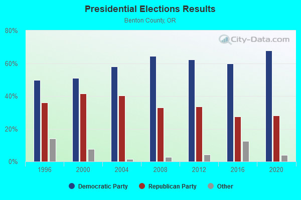
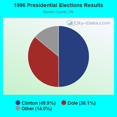
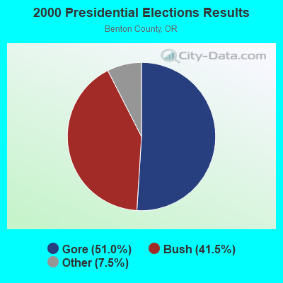
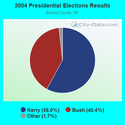
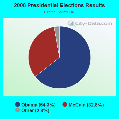
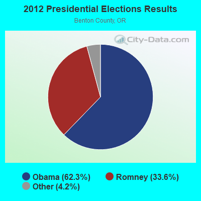
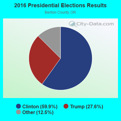
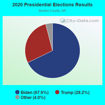
Graphs represent county-level data. Detailed 2008 Election Results
Religion statistics for Southwest Benton, OR (based on Benton County data)
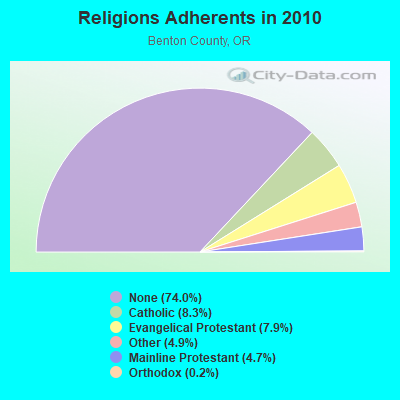
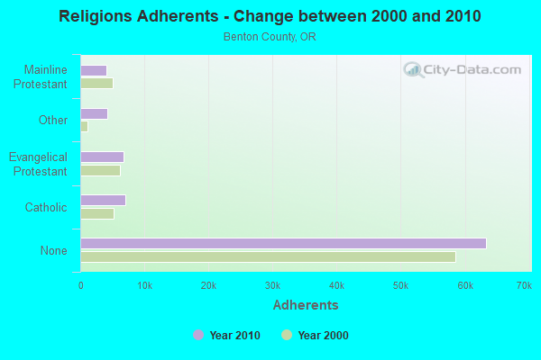
| Religion | Adherents | Congregations |
|---|---|---|
| Catholic | 7,077 | 2 |
| Evangelical Protestant | 6,758 | 50 |
| Other | 4,164 | 19 |
| Mainline Protestant | 4,065 | 11 |
| Orthodox | 160 | 2 |
| None | 63,355 | - |
Food Environment Statistics:
| This county: | 1.73 / 10,000 pop. |
| State: | 2.03 / 10,000 pop. |
| Benton County: | 0.37 / 10,000 pop. |
| Oregon: | 0.33 / 10,000 pop. |
| Benton County: | 1.60 / 10,000 pop. |
| Oregon: | 2.01 / 10,000 pop. |
| This county: | 1.48 / 10,000 pop. |
| Oregon: | 1.69 / 10,000 pop. |
| This county: | 7.15 / 10,000 pop. |
| State: | 9.93 / 10,000 pop. |
| Benton County: | 6.0% |
| Oregon: | 7.4% |
| Here: | 22.0% |
| Oregon: | 25.6% |
| Benton County: | 16.9% |
| Oregon: | 14.2% |
Strongest AM radio stations in Southwest Benton:
- KPNW (1120 AM; 50 kW; EUGENE, OR; Owner: CAPSTAR TX LIMITED PARTNERSHIP)
- KZTU (660 AM; 10 kW; JUNCTION CITY, OR; Owner: PAMPLIN BROADCASTING-OREGON, INC.)
- KDUN (1030 AM; 50 kW; REEDSPORT, OR; Owner: PAMPLIN BROADCASTING-OREGON, INC.)
- KOAC (550 AM; 5 kW; CORVALLIS, OR; Owner: OREGON PUBLIC BROADCASTING)
- KPOJ (620 AM; 50 kW; PORTLAND, OR; Owner: CITICASTERS LICENSES, L.P.)
- KXL (750 AM; 50 kW; PORTLAND, OR; Owner: ROSE CITY RADIO CORPORATION)
- KUGN (590 AM; 5 kW; EUGENE, OR; Owner: CUMULUS LICENSING CORP.)
- KEX (1190 AM; 50 kW; PORTLAND, OR; Owner: CITICASTERS LICENSES, L.P.)
- KNPT (1310 AM; 5 kW; NEWPORT, OR; Owner: YAOUINA BAY COMMUNICATIONS, INC.)
- KPAM (860 AM; 50 kW; TROUTDALE, OR; Owner: PAMPLIN BROADCASTING-OREGON, INC.)
- KOTK (1080 AM; 50 kW; PORTLAND, OR; Owner: FISHER BROADCASTING - PORTLAND RADIO, L.L.C.)
- KKSN (1520 AM; 50 kW; OREGON CITY, OR; Owner: ENTERCOM PORTLAND LICENSE, LLC)
- KWIP (880 AM; 5 kW; DALLAS, OR; Owner: JUPITER COMMUNICATIONS CORPORATION)
Strongest FM radio stations in Southwest Benton:
- KDUK-FM (104.7 FM; FLORENCE, OR; Owner: CAPSTAR TX LIMITED PARTNERSHIP)
- KFLY (101.5 FM; CORVALLIS, OR; Owner: CITICASTERS LICENSES, L.P.)
- K207BX (89.3 FM; EUGENE, OR; Owner: PENSACOLA CHRISTIAN COLLEGE, INC.)
- K203BT (88.5 FM; EUGENE, OR; Owner: CALVARY CHAPEL OF TWIN FALLS, INC.)
- K214CI (90.7 FM; EUGENE, OR; Owner: EDUCATIONAL MEDIA FOUNDATION)
- KHPE (107.9 FM; ALBANY, OR; Owner: INTEGRITY MEDIA, INC.)
- K264AA (100.7 FM; CORVALLIS, ETC., OR; Owner: THE KBOO FOUNDATION)
- KLOO-FM (106.3 FM; CORVALLIS, OR; Owner: CITICASTERS LICENSES, L.P.)
- K276BU (103.1 FM; CORVALLIS, OR; Owner: OREGON PUBLIC BROADCASTING)
- K243AL (96.5 FM; CORVALLIS, OR; Owner: CUMULUS LICENSING CORP.)
- KRKT-FM (99.9 FM; ALBANY, OR; Owner: CITICASTERS LICENSES, L.P.)
- KODZ (99.1 FM; EUGENE, OR; Owner: CAPSTAR TX LIMITED PARTNERSHIP)
- KSND (95.1 FM; LINCOLN CITY, OR; Owner: RADIO BEAM, LLC)
- KLVU (107.1 FM; SWEET HOME, OR; Owner: EDUCATIONAL MEDIA FOUNDATION)
- KEHK (102.3 FM; BROWNSVILLE, OR; Owner: CUMULUS LICENSING CORP.)
- KWVZ (91.5 FM; FLORENCE, OR; Owner: OREGON STATE BOARD OF HIGHER ED.)
- KKNU (93.1 FM; SPRINGFIELD-EUGENE, OR; Owner: MCKENZIE RIVER BROADCASTING COMPANY, INC.)
- KMGE (94.5 FM; EUGENE, OR; Owner: MCKENZIE RIVER BROADCASTING COMPANY, INC.)
- KUJZ (95.3 FM; CRESWELL, OR; Owner: CUMULUS LICENSING CORP.)
- KZEL-FM (96.1 FM; EUGENE, OR; Owner: CUMULUS LICENSING CORP.)
TV broadcast stations around Southwest Benton:
- KLSR-TV (Channel 34; EUGENE, OR; Owner: CALIFORNIA OREGON BROADCASTING, INC.)
- KVAL-TV (Channel 13; EUGENE, OR; Owner: FISHER BROADCASTING - OREGON TV, L.L.C.)
- KEPB-TV (Channel 28; EUGENE, OR; Owner: OREGON PUBLIC BROADCASTING)
- KOAC-TV (Channel 7; CORVALLIS, OR; Owner: OREGON PUBLIC BROADCASTING)
- K14GW (Channel 14; CORVALLIS, OR; Owner: CALIFORNIA OREGON BROADCASTING, INC.)

- 51.4%Electricity
- 29.9%Wood
- 7.5%Utility gas
- 5.5%Bottled, tank, or LP gas
- 4.1%Fuel oil, kerosene, etc.
- 1.6%Other fuel

- 44.7%Electricity
- 43.2%Wood
- 7.3%Fuel oil, kerosene, etc.
- 3.9%Bottled, tank, or LP gas
- 1.0%Other fuel
Southwest Benton compared to Oregon state average:
- Unemployed percentage significantly below state average.
- Black race population percentage significantly below state average.
- Hispanic race population percentage significantly below state average.
- Median age above state average.
- Foreign-born population percentage significantly below state average.
- Renting percentage below state average.
- Length of stay since moving in significantly above state average.
- Number of rooms per house significantly below state average.
- House age significantly below state average.