Sugar Grove, Kentucky
Submit your own pictures of this place and show them to the world
- OSM Map
- General Map
- Google Map
- MSN Map

| Males: 902 | |
| Females: 890 |
| Median resident age: | 35.5 years |
| Kentucky median age: | 35.9 years |
Zip code: 42261
| Sugar Grove: | $57,292 |
| KY: | $59,341 |
Estimated per capita income in 2022: $29,925 (it was $18,080 in 2000)
Sugar Grove CCD income, earnings, and wages data
Estimated median house or condo value in 2022: $117,303 (it was $56,300 in 2000)
| Sugar Grove: | $117,303 |
| KY: | $196,300 |
Detailed information about poverty and poor residents in Sugar Grove, KY


- 1,73098.4%White alone
- 100.6%American Indian alone
- 80.5%Hispanic
- 40.2%Black alone
- 40.2%Two or more races
- 20.1%Asian alone

Races in Sugar Grove detailed stats: ancestries, foreign born residents, place of birth
 Recent articles from our blog. Our writers, many of them Ph.D. graduates or candidates, create easy-to-read articles on a wide variety of topics.
Current Local Time: CST time zone
Land area: 86.2 square miles.
Population density: 21 people per square mile (very low).

| Sugar Grove CCD: | 0.5% ($292) |
| Kentucky: | 0.8% ($610) |
Nearest city with pop. 50,000+: Owensboro, KY  (51.1 miles , pop. 54,067).
Nearest city with pop. 200,000+: Metropolitan Government, TN (64.8 miles , pop. 569,891).
Nearest city with pop. 1,000,000+: Chicago, IL (332.5 miles , pop. 2,896,016).
Nearest cities:
), ), ), )Latitude: 37.09 N, Longitude: 86.72 W
Area code commonly used in this area: 270


| Here: | 4.4% |
| Kentucky: | 3.8% |

- Transportation equipment (11.3%)
- Construction (10.4%)
- Health care (7.2%)
- Metal & metal products (6.4%)
- Agriculture, forestry, fishing & hunting (5.7%)
- Repair & maintenance (5.7%)
- Plastics & rubber products (5.5%)

- Construction (20.3%)
- Metal & metal products (9.9%)
- Repair & maintenance (9.5%)
- Agriculture, forestry, fishing & hunting (8.4%)
- Plastics & rubber products (5.5%)
- Transportation equipment (4.6%)
- Motor vehicle & parts dealers (2.9%)

- Transportation equipment (18.2%)
- Health care (13.4%)
- Accommodation & food services (8.1%)
- Educational services (6.0%)
- Plastics & rubber products (5.5%)
- Finance & insurance (5.1%)
- Department & other general merchandise stores (3.7%)

- Metal workers and plastic workers (9.5%)
- Other production occupations, including supervisors (7.3%)
- Vehicle and mobile equipment mechanics, installers, and repairers (7.0%)
- Secretaries and administrative assistants (4.7%)
- Driver/sales workers and truck drivers (4.7%)
- Electrical equipment mechanics and other installation, maintenance, and repair workers, including supervisors (3.9%)
- Assemblers and fabricators (3.5%)

- Vehicle and mobile equipment mechanics, installers, and repairers (13.7%)
- Metal workers and plastic workers (12.1%)
- Electrical equipment mechanics and other installation, maintenance, and repair workers, including supervisors (7.7%)
- Driver/sales workers and truck drivers (7.5%)
- Construction traders workers except carpenters, electricians, painters, plumbers, and construction laborers (4.8%)
- Construction laborers (4.4%)
- Other production occupations, including supervisors (4.2%)

- Other production occupations, including supervisors (10.6%)
- Secretaries and administrative assistants (9.7%)
- Metal workers and plastic workers (6.7%)
- Cashiers (5.5%)
- Assemblers and fabricators (5.5%)
- Material recording, scheduling, dispatching, and distributing workers (5.3%)
- Nursing, psychiatric, and home health aides (5.1%)
Average climate in Sugar Grove, Kentucky
Based on data reported by over 4,000 weather stations


Tornado activity:
Sugar Grove-area historical tornado activity is slightly above Kentucky state average. It is 53% greater than the overall U.S. average.
On 4/3/1974, a category F4 (max. wind speeds 207-260 mph) tornado 24.1 miles away from the Sugar Grove place center injured 2 people.
On 4/3/1974, a category F5 (max. wind speeds 261-318 mph) tornado 45.3 miles away from the place center killed 31 people and injured 270 people and caused between $500,000 and $5,000,000 in damages.
Earthquake activity:
Sugar Grove-area historical earthquake activity is significantly above Kentucky state average. It is 185% greater than the overall U.S. average.On 4/18/2008 at 09:36:59, a magnitude 5.4 (5.1 MB, 4.8 MS, 5.4 MW, 5.2 MW, Class: Moderate, Intensity: VI - VII) earthquake occurred 113.8 miles away from the city center
On 4/18/2008 at 09:36:59, a magnitude 5.2 (5.2 MW, Depth: 8.9 mi) earthquake occurred 113.8 miles away from the city center
On 6/18/2002 at 17:37:15, a magnitude 5.0 (4.3 MB, 4.6 MW, 5.0 LG) earthquake occurred 85.1 miles away from the city center
On 6/10/1987 at 23:48:54, a magnitude 5.1 (4.9 MB, 4.4 MS, 4.6 MS, 5.1 LG) earthquake occurred 135.5 miles away from Sugar Grove center
On 7/27/1980 at 18:52:21, a magnitude 5.2 (5.1 MB, 4.7 MS, 5.0 UK, 5.2 UK) earthquake occurred 170.2 miles away from the city center
On 4/18/2008 at 15:14:16, a magnitude 4.8 (4.5 MB, 4.8 MW, 4.6 MW, Class: Light, Intensity: IV - V) earthquake occurred 114.0 miles away from Sugar Grove center
Magnitude types: regional Lg-wave magnitude (LG), body-wave magnitude (MB), surface-wave magnitude (MS), moment magnitude (MW)
Natural disasters:
The number of natural disasters in Butler County (19) is greater than the US average (15).Major Disasters (Presidential) Declared: 14
Emergencies Declared: 2
Causes of natural disasters: Floods: 13, Storms: 11, Mudslides: 7, Landslides: 5, Tornadoes: 5, Winter Storms: 4, Snowstorms: 2, Blizzard: 1, Freeze: 1, Hurricane: 1, Snow: 1, Wind: 1, Other: 1 (Note: some incidents may be assigned to more than one category).
Colleges/universities with over 2000 students nearest to Sugar Grove:
- Southcentral Kentucky Community and Technical College (about 16 miles; Bowling Green, KY; Full-time enrollment: 2,794)
- Western Kentucky University (about 17 miles; Bowling Green, KY; FT enrollment: 16,942)
- Hopkinsville Community College (about 46 miles; Hopkinsville, KY; FT enrollment: 2,269)
- Madisonville Community College (about 48 miles; Madisonville, KY; FT enrollment: 2,082)
- Owensboro Community and Technical College (about 48 miles; Owensboro, KY; FT enrollment: 2,754)
- Volunteer State Community College (about 52 miles; Gallatin, TN; FT enrollment: 5,311)
- Austin Peay State University (about 53 miles; Clarksville, TN; FT enrollment: 8,621)
Points of interest:
Notable location: Second District Fire Department (A). Display/hide its location on the map
Churches in Sugar Grove include: Little Muddy Church (A), Richland Church (B), Sandy Creek Church (C), Carved Rock Church (D), Shiloh Church (E), Ebenezer Church (F). Display/hide their locations on the map
Cemeteries: Richelieu Cemetery (1), Bailey Cemetery (2), Orange Cemetery (3), New Tuck Cemetery (4), Lee Cemetery (5), Githens Cemetery (6), McKinney Cemetery (7). Display/hide their locations on the map
Reservoir: Subletts Lake (A). Display/hide its location on the map
Streams, rivers, and creeks: Flat Rock Branch (A), Boston Lick Creek (B), Dallam Creek (C), Little Muddy Creek (D), Cane Ridge Creek (E), Brushy Fork (F), Richland Creek (G), Holcomb Branch (H), Hocker Branch (I). Display/hide their locations on the map
| This place: | 2.5 people |
| Kentucky: | 2.5 people |
| This place: | 72.7% |
| Whole state: | 66.9% |
| This place: | 7.5% |
| Whole state: | 6.4% |
Likely homosexual households (counted as self-reported same-sex unmarried-partner households)
- Lesbian couples: 0.1% of all households
- Gay men: 0.6% of all households
| This place: | 13.1% |
| Whole state: | 15.8% |
| This place: | 1.8% |
| Whole state: | 6.6% |
For population 15 years and over in Sugar Grove:

- Never married: 19.1%
- Now married: 68.4%
- Separated: 1.3%
- Widowed: 6.5%
- Divorced: 6.0%
For population 25 years and over in Sugar Grove:
- High school or higher: 65.3%
- Bachelor's degree or higher: 6.5%
- Graduate or professional degree: 1.8%
- Unemployed: 3.6%
- Mean travel time to work (commute): 32.6 minutes


| Here: | 12.7 |
| Kentucky average: | 13.8 |
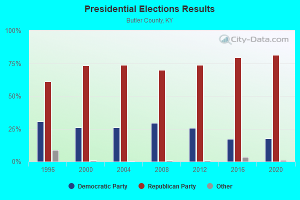
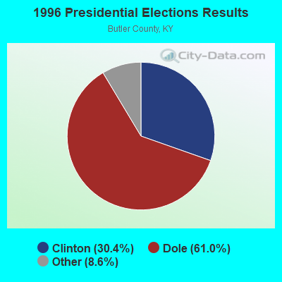
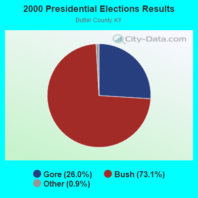
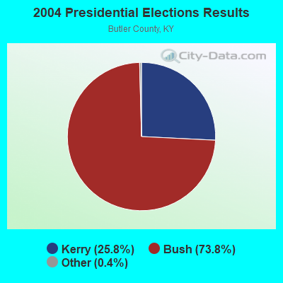
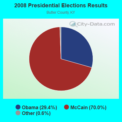
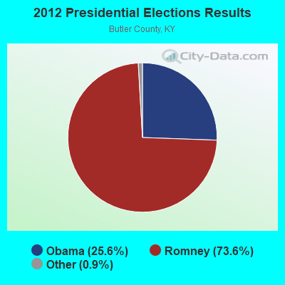
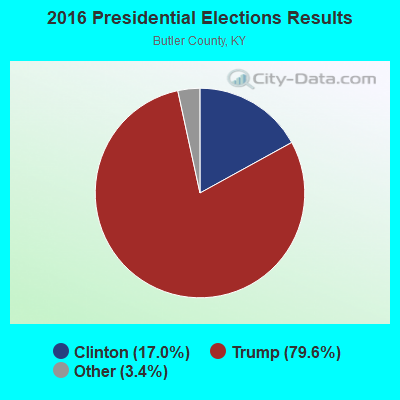
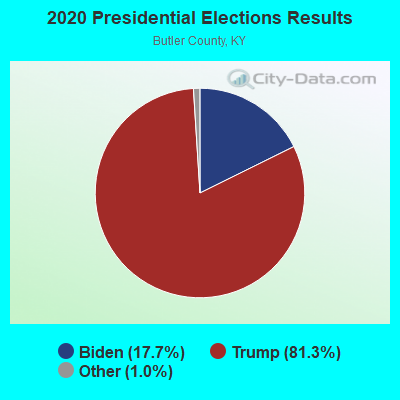
Graphs represent county-level data. Detailed 2008 Election Results
Religion statistics for Sugar Grove, KY (based on Butler County data)
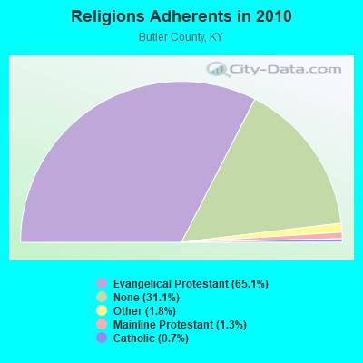
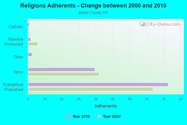
| Religion | Adherents | Congregations |
|---|---|---|
| Evangelical Protestant | 8,255 | 46 |
| Other | 230 | 1 |
| Mainline Protestant | 169 | 3 |
| Catholic | 95 | 1 |
| None | 3,941 | - |
Food Environment Statistics:
| Butler County: | 5.30 / 10,000 pop. |
| Kentucky: | 2.19 / 10,000 pop. |
| Butler County: | 0.76 / 10,000 pop. |
| State: | 0.74 / 10,000 pop. |
| This county: | 4.54 / 10,000 pop. |
| Kentucky: | 4.36 / 10,000 pop. |
| Here: | 5.30 / 10,000 pop. |
| Kentucky: | 5.74 / 10,000 pop. |
| Butler County: | 10.6% |
| Kentucky: | 11.0% |
| Butler County: | 31.3% |
| Kentucky: | 30.0% |
| Butler County: | 22.0% |
| State: | 15.9% |
Strongest AM radio stations in Sugar Grove:
- WKCT (930 AM; 5 kW; BOWLING GREEN, KY; Owner: DAILY NEWS BROADCASTING CO.)
- WSM (650 AM; 50 kW; NASHVILLE, TN; Owner: GAYLORD ENTERTAINMENT COMPANY)
- WKDA (1200 AM; 50 kW; NASHVILLE, TN; Owner: RADIO NASHVILLE, INC.)
- WAMB (1160 AM; 50 kW; DONELSON, TN; Owner: GREAT SOUTHERN BROADCASTING COMPANY, INC.)
- WLAC (1510 AM; 50 kW; NASHVILLE, TN; Owner: CAPSTAR TX LIMITED PARTNERSHIP)
- WNQM (1300 AM; 50 kW; NASHVILLE, TN; Owner: WNQM. INC.)
- WLBQ (1570 AM; 1 kW; MORGANTOWN, KY; Owner: BUTLER COUNTY BROADCASTING CO.)
- WRUS (610 AM; 2 kW; RUSSELLVILLE, KY; Owner: LOGAN RADIO INCORPORATED)
- WHAS (840 AM; 50 kW; LOUISVILLE, KY; Owner: CLEAR CHANNEL BROADCASTING LICENSES, INC.)
- WPLN (1430 AM; 15 kW; MADISON, TN)
- WBGN (1340 AM; 1 kW; BOWLING GREEN, KY; Owner: FOREVER COMMUNICATIONS INC)
- WWAM (820 AM; daytime; 50 kW; JASPER, TN; Owner: SHELTON BROADCASTING SYSTEM)
- WHIN (1010 AM; 5 kW; GALLATIN, TN; Owner: WHIN, INC.)
Strongest FM radio stations in Sugar Grove:
- WKYU-FM (88.9 FM; BOWLING GREEN, KY; Owner: WESTERN KENTUCKY UNIVERSITY)
- WUBT (101.1 FM; RUSSELLVILLE, KY; Owner: CAPSTAR TX LIMITED PARTNERSHIP)
- WQXQ (101.9 FM; CENTRAL CITY, KY; Owner: STARLIGHT BROADCASTING CO., INC.)
- WCVK (90.7 FM; BOWLING GREEN, KY; Owner: BOWLING GREEN COMMTY. B/CSTG, INC.)
- WBVR-FM (96.7 FM; AUBURN, KY; Owner: FOREVER COMMUNICATIONS INC)
- WWHR (91.7 FM; BOWLING GREEN, KY; Owner: WESTERN KENTUCKY UNIVERSITY)
- W203BI (88.5 FM; BOWLING GREEN, KY; Owner: WAY-FM MEDIA GROUP, INC.)
- WGGC (95.1 FM; GLASGOW, KY; Owner: HERITAGE COMMUNICATIONS, INC.)
- WKLX (100.7 FM; BROWNSVILLE, KY; Owner: CHARLES M. ANDERSON)
- WNTC (103.9 FM; DRAKESBORO, KY; Owner: NASHVILLE'S SPORTSRADIO, INCORPORATED)
- WUHU (107.1 FM; SMITHS GROVE, KY; Owner: FOREVER COMMUNICATIONS INC)
- WBKR (92.5 FM; OWENSBORO, KY; Owner: REGENT BROADCASTING OF EVANSVILLE/OWENSBORO, INC.)
- WVVR (100.3 FM; HOPKINSVILLE, KY; Owner: SAGA COMMUNICATIONS OF TUCKESSEE, LLC)
- WDNS (93.3 FM; BOWLING GREEN, KY; Owner: DAILY NEWS BROADCASTING COMPANY)
TV broadcast stations around Sugar Grove:
- W62CJ (Channel 62; JACKSON, TN; Owner: MS COMMUNICATIONS, LLC)
- WKGB-TV (Channel 53; BOWLING GREEN, KY; Owner: KENTUCKY AUTHORITY FOR EDUCATIONAL TV)
- WBKO (Channel 13; BOWLING GREEN, KY; Owner: GRAY MIDAMERICA TV LICENSEE CORP.)
- WKYU-TV (Channel 24; BOWLING GREEN, KY; Owner: WESTERN KENTUCKY UNIVERSITY)
- WPGD (Channel 50; HENDERSONVILLE, TN; Owner: TRINITY BROADCASTING NETWORK)
- WNKY (Channel 40; BOWLING GREEN, KY; Owner: MMK LICENSE LLC)
FCC Registered Broadcast Land Mobile Towers:
1- 3 Mi W (Lat: 37.083389 Lon: -86.708333), Structure height: 20 m, Call Sign: WNCY699,
Assigned Frequencies: 452.850 MHz, Grant Date: 10/17/2000, Expiration Date: 12/03/2005, Cancellation Date: 11/11/2005, Registrant: Epec Communications Corporation, 1900 5th Ave North, Birmingham, AL 35226, Phone: (205) 325-7328, Fax: (205) 325-3730, Email:

- 46.3%Electricity
- 43.6%Bottled, tank, or LP gas
- 6.2%Wood
- 1.9%Fuel oil, kerosene, etc.
- 1.0%Utility gas
- 1.0%No fuel used

- 42.7%Electricity
- 28.1%Bottled, tank, or LP gas
- 21.3%Fuel oil, kerosene, etc.
- 7.9%Wood
Sugar Grove compared to Kentucky state average:
- Median house value below state average.
- Unemployed percentage significantly below state average.
- Black race population percentage significantly below state average.
- Hispanic race population percentage significantly below state average.
- Median age below state average.
- Foreign-born population percentage significantly below state average.
- Renting percentage below state average.
- Length of stay since moving in significantly above state average.
- Number of rooms per house significantly below state average.
- House age significantly below state average.
- Number of college students below state average.
- Percentage of population with a bachelor's degree or higher significantly below state average.