Barberton Northend (N. Barberton) neighborhood in Barberton, Ohio (OH), 44203 detailed profile
Settings
X


Business Search - 14 Million verified businesses
Area: 4.234 square miles
Population: 11,355
Population density:
| Barberton Northend (N. Barberton): | 2,682 people per square mile |
| Barberton: | 2,792 people per square mile |

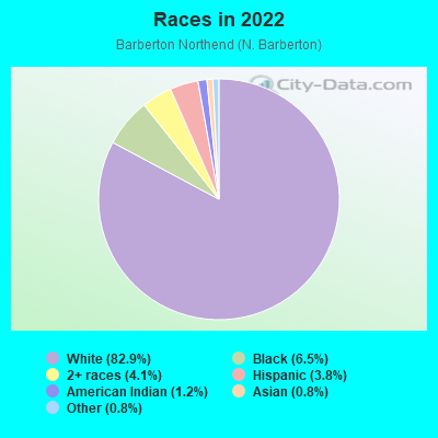
- 10,00582.9%White
- 7876.5%Black
- 4894.1%Two or more races
- 4643.8%Hispanic or Latino
- 1401.2%American Indian
- 920.8%Asian
- 920.8%Some other race
Median household income in 2022:
| Barberton Northend (N. Barberton): | $58,987 |
| Barberton: | $49,289 |
Distribution of median household income
![Distribution of median household income]()
- 198Less than $10,000
- 694$10,000 to $19,999
- 575$20,000 to $29,999
- 590$30,000 to $39,999
- 539$40,000 to $49,999
- 602$50,000 to $59,999
- 651$60,000 to $74,999
- 574$75,000 to $99,999
- 391$100,000 to $124,999
- 273$125,000 to $149,999
- 355$150,000 to $199,999
- 223$200,000 or more

Distribution of owner-occupied house/condo value
![Distribution of owner-occupied house/condo value]()
- 1,008Less than $50,000
- 2,388$50,000 to $99,999
- 990$100,000 to $149,999
- 494$150,000 to $199,999
- 239$200,000 to $249,999
- 232$250,000 to $299,999
- 250$300,000 to $399,999
- 60$400,000 to $499,999
- 37$500,000 to $749,999
- 48$750,000 to $999,999

Distribution of rent paid by renters
![Distribution of rent paid by renters]()
- 187Less than $100
- 336$100 to $199
- 537$200 to $299
- 505$300 to $399
- 628$400 to $499
- 722$500 to $599
- 290$600 to $699
- 719$700 to $799
- 301$800 to $899
- 195$900 to $999
- 65$1,000 to $1,249
- 30$1,250 to $1,499
- 126$2,000 or more

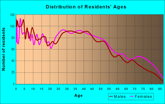
| Males: | 5,555 |
| Females: | 5,799 |
Males:
| This neighborhood: | 40.5 years |
| Whole city: | 39.3 years |
| This neighborhood: | 43.5 years |
| Whole city: | 41.6 years |
Average household size:
| Barberton Northend (N. Barberton): | 4.9 people |
| Barberton: | 2.3 people |
Percentage of family households:
| Barberton Northend (N. Barberton): | 44.4% |
| Barberton: | 40.8% |
| Here: | 43.2% |
| Barberton: | 35.4% |
Percentage of married-couple families with children (among all households):
| Barberton Northend (N. Barberton): | 28.4% |
| Barberton: | 23.2% |
Percentage of single-mother households (among all households):
| Barberton Northend (N. Barberton): | 13.1% |
| Barberton: | 17.5% |
Percentage of never married males 15 years old and over:
Percentage of never married females 15 years old and over:
| Barberton Northend (N. Barberton): | 19.9% |
| Barberton: | 17.9% |
Percentage of never married females 15 years old and over:
| Barberton Northend (N. Barberton): | 14.3% |
| city: | 14.9% |
Percentage of people that speak English not well or not at all:
| Barberton Northend (N. Barberton): | 0.4% |
| Barberton: | 0.7% |
Percentage of people born in this state:
Percentage of people born in another U.S. state:
Percentage of native residents but born outside the U.S.:
Percentage of foreign born residents:
| Here: | 84.9% |
| Barberton: | 84.2% |
Percentage of people born in another U.S. state:
| Barberton Northend (N. Barberton): | 13.1% |
| Barberton: | 13.9% |
Percentage of native residents but born outside the U.S.:
| Here: | 0.5% |
| city: | 0.5% |
Percentage of foreign born residents:
| Here: | 1.7% |
| Barberton: | 1.4% |
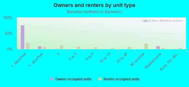
Owner-occupied
Renter-occupied

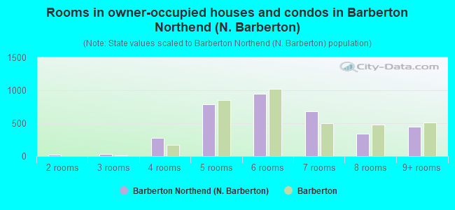
- Rooms in owner-occupied houses and condos in Barberton Northend <
> - 01 room
- 252 rooms
- 373 rooms
- 2804 rooms
- 7855 rooms
- 9446 rooms
- 6767 rooms
- 3428 rooms
- 4509+ rooms
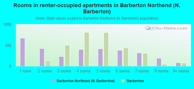
- Rooms in renter-occupied apartments in Barberton Northend <
> - 6761 room
- 4272 rooms
- 2363 rooms
- 4014 rooms
- 4215 rooms
- 3816 rooms
- 3187 rooms
- 1948 rooms
- 879+ rooms
Owner-occupied
Renter-occupied
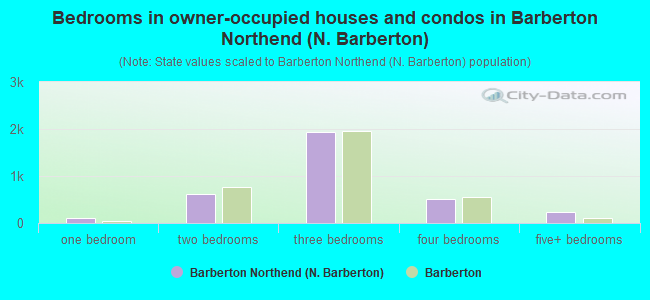
- Bedrooms in owner-occupied houses and condos in Barberton Northend <
> - 0no bedroom
- 1001 bedroom
- 6232 bedrooms
- 1,9383 bedrooms
- 5074 bedrooms
- 2445+ bedrooms
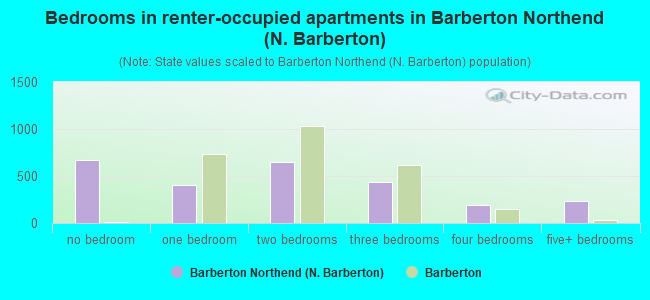
- Bedrooms in renter-occupied apartments in Barberton Northend <
> - 665no bedroom
- 4071 bedroom
- 6452 bedrooms
- 4413 bedrooms
- 1934 bedrooms
- 2305+ bedrooms
Average number of cars or other vehicles available in houses/condos:
Average number of cars or other vehicles available in apartments:
| This neighborhood: | 1.6 |
| Barberton: | 1.8 |
Average number of cars or other vehicles available in apartments:
| Here: | 1.6 |
| city: | 1.2 |
Percentage of units with a mortgage:
| Barberton Northend (N. Barberton): | 56.6% |
| Barberton: | 60.5% |
Average estimated value of detached houses in 2022 (81.6% of all units):
| Barberton Northend (N. Barberton): | $134,931 |
| Ohio: | $254,366 |
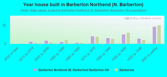
- Year house built in Barberton Northend <
> - 362020 or later
- 2402010 to 2019
- 3742000 to 2009
- 2141990 to 1999
- 1531980 to 1989
- 8491970 to 1979
- 6501960 to 1969
- 1,0211950 to 1959
- 5981940 to 1949
- 1,8711939 or earlier
City-data.com crime index for city in 2020 (higher means more crime):
| City: | 231.1 |
| U.S. average: | 219.5 |
Travel time to work (commute)
![Travel time to work (commute)]()
- 216Less than 5 minutes
- 8165 to 9 minutes
- 59610 to 14 minutes
- 74715 to 19 minutes
- 91720 to 24 minutes
- 34625 to 29 minutes
- 47430 to 34 minutes
- 9235 to 39 minutes
- 16340 to 44 minutes
- 25145 to 59 minutes
- 16060 to 89 minutes
- 14890 or more minutes

Means of transportation to work
![Means of transportation to work]()
- 84.7%4,229Drove a car alone
- 7.5%372Carpooled
- 0.3%14Bus
- 1.2%62Light rail, streetcar or trolley
- 6.9%344Taxi
- 1.9%95Motorcycle
- 0.5%26Bicycle
- 3.1%157Walked
- 4.7%233Other means
- 7.3%366Worked at home

Time leaving home to go to work
![Time leaving home to go to work]()
- 23812:00 a.m. to 4:59 a.m.
- 1535:00 a.m. to 5:29 a.m.
- 2535:30 a.m. to 5:59 a.m.
- 3886:00 a.m. to 6:29 a.m.
- 5226:30 a.m. to 6:59 a.m.
- 6977:00 a.m. to 7:29 a.m.
- 5527:30 a.m. to 7:59 a.m.
- 4058:00 a.m. to 8:29 a.m.
- 1818:30 a.m. to 8:59 a.m.
- 3219:00 a.m. to 9:59 a.m.
- 9010:00 a.m. to 10:59 a.m.
- 7811:00 a.m. to 11:59 a.m.
- 49012:00 p.m. to 3:59 p.m.
- 4964:00 p.m. to 11:59 p.m.

Occupations of males:
- Percentage of males in management occupations (except farmers):
Here: 7.1% city: 7.6%
- Percentage of males in business and financial operations occupations:
Here: 3.7% city: 4.1%
- Percentage of males in computer and mathematical occupations:
Here: 5.4% city: 3.3%
- Percentage of males in architecture and engineering occupations:
Here: 1.3% city: 1.5%
- Percentage of males in community and social services occupations:
Here: 1.8% city: 0.6%
- Percentage of males in arts, design, entertainment, sports, and media occupations:
Here: 1.5% city: 2.6%
- Percentage of males in healthcare practitioners and technical occupations:
Here: 2.0% city: 2.4%
- Percentage of males in service occupations:
Here: 16.7% city: 11.8%
- Percentage of males in sales and office occupations:
Here: 11.8% city: 17.2%
- Percentage of males in construction, extraction, and maintenance occupations:
Here: 10.0% city: 10.2%
- Percentage of males in production occupations:
Here: 14.9% city: 15.5%
- Percentage of males in transportation occupations:
Here: 6.1% city: 5.4%
- Percentage of males in material moving occupations:
Here: 6.7% city: 7.3%
Occupations of females:
- Percentage of females in management occupations (except farmers):
Here: 4.8% city: 5.1%
- Percentage of females in business and financial operations occupations:
Here: 5.5% city: 4.9%
- Percentage of females in computer and mathematical occupations:
Here: 1.5% city: 0.3%
- Percentage of females in community and social services occupations:
Here: 4.3% city: 2.1%
- Percentage of females in education, training, and library occupations:
Here: 7.6% city: 6.5%
- Percentage of females in healthcare practitioners and technical occupations:
Here: 7.1% city: 9.0%
- Percentage of females in service occupations:
Here: 23.2% city: 23.9%
- Percentage of females in sales and office occupations:
Here: 35.2% city: 35.0%
- Percentage of females in production occupations:
Here: 5.3% city: 5.4%
- Percentage of females in material moving occupations:
Here: 4.0% city: 3.6%
Percentage of people 16-64 in Armed Forces:
| Barberton Northend (N. Barberton): | 0.6% |
| Barberton: | 0.5% |
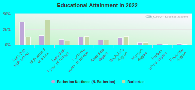
Education in this neighborhood (subdivision or community):
- Percentage of people 3 years and older in K-12 schools:
Barberton Northend (N. Barberton): 26.0% Barberton: 16.6%
- Percentage of people 3 years and older in undergraduate colleges:
Barberton Northend (N. Barberton): 5.1% Barberton: 3.4%
- Percentage of people 3 years and older in grad. or professional schools:
Barberton Northend (N. Barberton): 1.4% Barberton: 0.5%
- Percentage of students K-12 enrolled in private schools:
Barberton Northend (N. Barberton): 70.9% Barberton: 5.5%
Percentage of population below poverty level:
| Barberton Northend (N. Barberton): | 13.1% |
| Barberton: | 16.1% |
Percentage of married-couple families with both working:
| Barberton Northend (N. Barberton): | 85.1% |
| Barberton: | 72.5% |
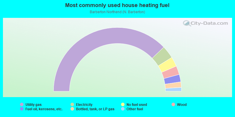
- 75.7%Utility gas
- 6.5%Electricity
- 4.9%No fuel used
- 4.4%Wood
- 3.8%Fuel oil, kerosene, etc.
- 2.8%Bottled, tank, or LP gas
- 1.9%Other fuel
Limited-access highways (interstate or state) in this neighborhood:
I- 76 (US Hwy 224)
Length: 5.28 miles
Directions: E-W, SE-NW
Directions: E-W, SE-NW
Highways in this neighborhood:
W State St (State Rte 619)
Length: 1.02 miles
Directions: N-S, SE-NW, SW-NE
Address range: 44 to 513
Directions: N-S, SE-NW, SW-NE
Address range: 44 to 513
State Rte 619 (5th St NE)
Length: 0.94 miles
Directions: E-W, N-S, SE-NW, SW-NE
Address range: 223 to 608
Directions: E-W, N-S, SE-NW, SW-NE
Address range: 223 to 608
Roads and streets:
N Wooster Rd
Length: 2.24 miles
Directions: E-W, SW-NE
Address range: 264 to 1255
Directions: E-W, SW-NE
Address range: 264 to 1255
Norton Ave
Length: 2.17 miles
Directions: E-W, SW-NE
Address range: 100 to 974
Directions: E-W, SW-NE
Address range: 100 to 974
Fairview Ave
Length: 1.41 miles
Directions: E-W, SE-NW
Address range: 1 to 899
Directions: E-W, SE-NW
Address range: 1 to 899
Brady Ave
Length: 1.24 miles
Direction: E-W
Address range: 471 to 970
Direction: E-W
Address range: 471 to 970
W Hopocan Ave
Length: 1.18 miles
Directions: E-W, SW-NE
Address range: 400 to 1099
Directions: E-W, SW-NE
Address range: 400 to 1099
Huston St E
Length: 1.18 miles
Direction: E-W
Address range: 200 to 732
Direction: E-W
Address range: 200 to 732
E State St
Length: 1.16 miles
Direction: SE-NW
Address range: 1 to 539
Direction: SE-NW
Address range: 1 to 539
E Hopocan Ave
Length: 1.16 miles
Direction: E-W
Address range: 250 to 719
Direction: E-W
Address range: 250 to 719
Morgan St
Length: 1.10 miles
Direction: E-W
Address range: 100 to 547
Direction: E-W
Address range: 100 to 547
Coventry Rd
Length: 1.08 miles
Direction: SW-NE
Address range: 654 to 1249
Direction: SW-NE
Address range: 654 to 1249
Washington Ave
Length: 1.06 miles
Direction: E-W
Address range: 280 to 720
Direction: E-W
Address range: 280 to 720
W Summit St
Length: 1.02 miles
Directions: E-W, SW-NE
Address range: 14 to 453
Directions: E-W, SW-NE
Address range: 14 to 453
Glenn St
Length: 1.02 miles
Directions: E-W, SE-NW
Address range: 75 to 511
Directions: E-W, SE-NW
Address range: 75 to 511
Clarkmill Rd
Length: 0.98 miles
Directions: N-S, SW-NE
Address range: 3262 to 3799
Directions: N-S, SW-NE
Address range: 3262 to 3799
Lincoln Ave
Length: 0.94 miles
Direction: E-W
Address range: 308 to 699
Direction: E-W
Address range: 308 to 699
Barber Rd
Length: 0.94 miles
Direction: N-S
Address range: 3122 to 3499
Direction: N-S
Address range: 3122 to 3499
Orchard Ave
Length: 0.83 miles
Directions: N-S, SW-NE
Address range: 500 to 926
Directions: N-S, SW-NE
Address range: 500 to 926
Franklin Ave
Length: 0.82 miles
Directions: E-W, SW-NE
Address range: 340 to 653
Directions: E-W, SW-NE
Address range: 340 to 653
Newton Ave (Newton St)
Length: 0.80 miles
Directions: E-W, N-S, SE-NW
Address range: 600 to 2006
Directions: E-W, N-S, SE-NW
Address range: 600 to 2006
Grand Blvd
Length: 0.74 miles
Directions: E-W, N-S, SE-NW
Address range: 1219 to 1599
Directions: E-W, N-S, SE-NW
Address range: 1219 to 1599
N Van Buren Ave
Length: 0.71 miles
Direction: SW-NE
Address range: 230 to 559
Direction: SW-NE
Address range: 230 to 559
Hazelwood Ave (Hazelwood St)
Length: 0.71 miles
Directions: E-W, N-S, SE-NW
Address range: 47 to 2999
Directions: E-W, N-S, SE-NW
Address range: 47 to 2999
Jefferson Ave
Length: 0.70 miles
Directions: E-W, SW-NE
Address range: 362 to 640
Directions: E-W, SW-NE
Address range: 362 to 640
Elmwood St (Elmwood Ave)
Length: 0.69 miles
Directions: E-W, N-S, SE-NW
Address range: 1 to 343
Directions: E-W, N-S, SE-NW
Address range: 1 to 343
Central Ave
Length: 0.66 miles
Directions: N-S, SE-NW, SW-NE
Address range: 1083 to 1425
Directions: N-S, SE-NW, SW-NE
Address range: 1083 to 1425
4th St NW
Length: 0.64 miles
Directions: N-S, SW-NE
Address range: 262 to 556
Directions: N-S, SW-NE
Address range: 262 to 556
Homewood Ave
Length: 0.64 miles
Directions: E-W, N-S, SW-NE
Address range: 654 to 1509
Directions: E-W, N-S, SW-NE
Address range: 654 to 1509
Romig Ave
Length: 0.62 miles
Direction: SW-NE
Address range: 900 to 1225
Direction: SW-NE
Address range: 900 to 1225
Grandview Ave
Length: 0.61 miles
Direction: E-W
Address range: 380 to 638
Direction: E-W
Address range: 380 to 638
6th St NE
Length: 0.59 miles
Direction: N-S
Address range: 219 to 533
Direction: N-S
Address range: 219 to 533
15th St NW
Length: 0.58 miles
Directions: N-S, SW-NE
Address range: 260 to 571
Directions: N-S, SW-NE
Address range: 260 to 571
Caroline Ave
Length: 0.56 miles
Direction: E-W
Address range: 1800 to 2021
Direction: E-W
Address range: 1800 to 2021
N Summit St
Length: 0.55 miles
Directions: N-S, SE-NW
Address range: 639 to 999
Directions: N-S, SE-NW
Address range: 639 to 999
Yonker St
Length: 0.55 miles
Directions: E-W, N-S, SE-NW
Address range: 51 to 281
Directions: E-W, N-S, SE-NW
Address range: 51 to 281
Connect Rd
Length: 0.54 miles
Direction: E-W
Address range: 376 to 2099
Direction: E-W
Address range: 376 to 2099
Wesleyan Ave
Length: 0.51 miles
Directions: E-W, N-S, SW-NE
Address range: 500 to 779
Directions: E-W, N-S, SW-NE
Address range: 500 to 779
Hermann St
Length: 0.50 miles
Direction: E-W
Address range: 64 to 284
Direction: E-W
Address range: 64 to 284
Hiram St W
Length: 0.49 miles
Direction: E-W
Address range: 1 to 208
Direction: E-W
Address range: 1 to 208
7th St NE
Length: 0.48 miles
Direction: N-S
Address range: 220 to 482
Direction: N-S
Address range: 220 to 482
Evergreen St
Length: 0.47 miles
Direction: E-W
Address range: 80 to 285
Direction: E-W
Address range: 80 to 285
5th St NW
Length: 0.46 miles
Direction: N-S
Address range: 262 to 511
Direction: N-S
Address range: 262 to 511
Newell St
Length: 0.46 miles
Direction: N-S
Address range: 260 to 499
Direction: N-S
Address range: 260 to 499
St Clair Ave
Length: 0.44 miles
Directions: N-S, SE-NW
Address range: 654 to 901
Directions: N-S, SE-NW
Address range: 654 to 901
3rd St NW
Length: 0.43 miles
Direction: N-S
Address range: 260 to 499
Direction: N-S
Address range: 260 to 499
17th St NW
Length: 0.42 miles
Direction: N-S
Address range: 316 to 554
Direction: N-S
Address range: 316 to 554
Summit Rd
Length: 0.42 miles
Directions: N-S, SE-NW
Address range: 4062 to 4399
Directions: N-S, SE-NW
Address range: 4062 to 4399
Norwood St
Length: 0.42 miles
Directions: E-W, SE-NW
Address range: 25 to 176
Directions: E-W, SE-NW
Address range: 25 to 176
Madison Ave
Length: 0.41 miles
Directions: N-S, SE-NW
Address range: 600 to 933
Directions: N-S, SE-NW
Address range: 600 to 933
Highland Ave
Length: 0.39 miles
Directions: E-W, SW-NE
Address range: 550 to 721
Directions: E-W, SW-NE
Address range: 550 to 721
4th St NE
Length: 0.38 miles
Direction: N-S
Address range: 220 to 425
Direction: N-S
Address range: 220 to 425
Mitchell St
Length: 0.36 miles
Direction: E-W
Address range: 47 to 206
Direction: E-W
Address range: 47 to 206
Perry Ave
Length: 0.36 miles
Direction: E-W
Address range: 888 to 1046
Direction: E-W
Address range: 888 to 1046
Van St
Length: 0.35 miles
Directions: E-W, SW-NE
Address range: 290 to 429
Directions: E-W, SW-NE
Address range: 290 to 429
Taft Ave
Length: 0.34 miles
Directions: E-W, SW-NE
Address range: 444 to 587
Directions: E-W, SW-NE
Address range: 444 to 587
Wilbur Ave
Length: 0.34 miles
Direction: E-W
Address range: 900 to 1037
Direction: E-W
Address range: 900 to 1037
Grace Ave
Length: 0.34 miles
Directions: N-S, SE-NW
Address range: 129 to 299
Directions: N-S, SE-NW
Address range: 129 to 299
Holmes Ave
Length: 0.34 miles
Direction: E-W
Address range: 500 to 662
Direction: E-W
Address range: 500 to 662
Fernwood Ave (Fernwood St)
Length: 0.34 miles
Directions: E-W, SE-NW
Address range: 31 to 184
Directions: E-W, SE-NW
Address range: 31 to 184
Woodbirch Ave
Length: 0.33 miles
Direction: E-W
Address range: 1395 to 1530
Direction: E-W
Address range: 1395 to 1530
Huntsberger Dr (Huntsberger St)
Length: 0.32 miles
Directions: E-W, SE-NW
Address range: 3300 to 3699
Directions: E-W, SE-NW
Address range: 3300 to 3699
N Way St
Length: 0.32 miles
Directions: E-W, N-S, SW-NE
Address range: 619 to 776
Directions: E-W, N-S, SW-NE
Address range: 619 to 776
Lloyd St
Length: 0.31 miles
Directions: N-S, SE-NW
Address range: 444 to 606
Directions: N-S, SE-NW
Address range: 444 to 606
Fawler Ave
Length: 0.30 miles
Direction: E-W
Address range: 1402 to 1530
Direction: E-W
Address range: 1402 to 1530
Oakwood St
Length: 0.29 miles
Direction: E-W
Address range: 61 to 199
Direction: E-W
Address range: 61 to 199
W Way St
Length: 0.29 miles
Direction: E-W
Address range: 140 to 259
Direction: E-W
Address range: 140 to 259
8th St NE
Length: 0.27 miles
Direction: N-S
Address range: 218 to 358
Direction: N-S
Address range: 218 to 358
Creedmore Ave
Length: 0.27 miles
Direction: E-W
Address range: 500 to 642
Direction: E-W
Address range: 500 to 642
Charles Ave
Length: 0.27 miles
Directions: E-W, N-S, SW-NE
Address range: 600 to 747
Directions: E-W, N-S, SW-NE
Address range: 600 to 747
Fairmount Ave
Length: 0.27 miles
Directions: N-S, SE-NW
Address range: 140 to 298
Directions: N-S, SE-NW
Address range: 140 to 298
Kilgore St
Length: 0.27 miles
Direction: N-S
Address range: 2543 to 2660
Direction: N-S
Address range: 2543 to 2660
Wunderlich Ave
Length: 0.26 miles
Direction: N-S
Address range: 255 to 413
Direction: N-S
Address range: 255 to 413
Powell Pl
Length: 0.26 miles
Direction: E-W
Address range: 519 to 623
Direction: E-W
Address range: 519 to 623
Wilson Ave
Length: 0.25 miles
Direction: E-W
Address range: 470 to 578
Direction: E-W
Address range: 470 to 578
W Waterloo Rd
Length: 0.24 miles
Directions: E-W, SE-NW
Address range: 1391 to 1599
Directions: E-W, SE-NW
Address range: 1391 to 1599
Burt St
Length: 0.24 miles
Directions: N-S, SE-NW, SW-NE
Address range: 551 to 641
Directions: N-S, SE-NW, SW-NE
Address range: 551 to 641
Kenmore Ave
Length: 0.24 miles
Direction: E-W
Address range: 1 to 103
Direction: E-W
Address range: 1 to 103
Huston St W
Length: 0.23 miles
Direction: E-W
Address range: 1 to 99
Direction: E-W
Address range: 1 to 99
St John St
Length: 0.22 miles
Direction: E-W
Address range: 100 to 173
Direction: E-W
Address range: 100 to 173
W Waterloo Rd (Waterloo Rd)
Length: 0.22 miles
Direction: E-W
Address range: 1423 to 1499
Direction: E-W
Address range: 1423 to 1499
Cordelia Ave
Length: 0.21 miles
Directions: E-W, N-S, SE-NW
Address range: 2600 to 2700
Directions: E-W, N-S, SE-NW
Address range: 2600 to 2700
Erie St
Length: 0.21 miles
Directions: E-W, N-S, SE-NW
Address range: 400 to 499
Directions: E-W, N-S, SE-NW
Address range: 400 to 499
Keller St
Length: 0.21 miles
Directions: E-W, SE-NW
Address range: 550 to 659
Directions: E-W, SE-NW
Address range: 550 to 659
Dunn St (Dunn Ave)
Length: 0.20 miles
Direction: N-S
Address range: 200 to 399
Direction: N-S
Address range: 200 to 399
Raymond Ave
Length: 0.20 miles
Direction: E-W
Address range: 870 to 966
Direction: E-W
Address range: 870 to 966
Kendale Dr
Length: 0.20 miles
Direction: E-W
Address range: 1390 to 1476
Direction: E-W
Address range: 1390 to 1476
Brown St
Length: 0.20 miles
Directions: E-W, SW-NE
Address range: 1 to 99
Directions: E-W, SW-NE
Address range: 1 to 99
Parkview Ave
Length: 0.19 miles
Direction: N-S
Address range: 500 to 607
Direction: N-S
Address range: 500 to 607
Sylvester St
Length: 0.19 miles
Directions: N-S, SE-NW
Address range: 100 to 198
Directions: N-S, SE-NW
Address range: 100 to 198
Irish Ln
Length: 0.19 miles
Directions: E-W, SW-NE
Address range: 290 to 369
Directions: E-W, SW-NE
Address range: 290 to 369
Hiram St E
Length: 0.19 miles
Directions: E-W, SE-NW
Address range: 1 to 99
Directions: E-W, SE-NW
Address range: 1 to 99
Princeton Ave
Length: 0.19 miles
Direction: N-S
Address range: 500 to 599
Direction: N-S
Address range: 500 to 599
Macy Ave
Length: 0.19 miles
Direction: SE-NW
Address range: 121 to 216
Direction: SE-NW
Address range: 121 to 216
Miami Ave
Length: 0.18 miles
Direction: N-S
Address range: 500 to 626
Direction: N-S
Address range: 500 to 626
Young Ave
Length: 0.18 miles
Directions: E-W, N-S, SE-NW, SW-NE
Address range: 941 to 999
Directions: E-W, N-S, SE-NW, SW-NE
Address range: 941 to 999
Carey Ave
Length: 0.18 miles
Direction: E-W
Address range: 1369 to 1469
Direction: E-W
Address range: 1369 to 1469
Horn St
Length: 0.18 miles
Direction: E-W
Address range: 200 to 299
Direction: E-W
Address range: 200 to 299
3rd St NE
Length: 0.17 miles
Direction: N-S
Address range: 209 to 342
Direction: N-S
Address range: 209 to 342
Broadview Ave
Length: 0.17 miles
Direction: N-S
Address range: 237 to 341
Direction: N-S
Address range: 237 to 341
Harding Ave
Length: 0.16 miles
Directions: E-W, SW-NE
Address range: 490 to 571
Directions: E-W, SW-NE
Address range: 490 to 571
9th St NE
Length: 0.16 miles
Direction: N-S
Address range: 204 to 304
Direction: N-S
Address range: 204 to 304
Lucas St
Length: 0.15 miles
Directions: E-W, SW-NE
Address range: 290 to 350
Directions: E-W, SW-NE
Address range: 290 to 350
Eagon St
Length: 0.15 miles
Direction: N-S
Address range: 1011 to 1099
Direction: N-S
Address range: 1011 to 1099
E Lake Ave
Length: 0.15 miles
Direction: E-W
Address range: 654 to 749
Direction: E-W
Address range: 654 to 749
Grant Ave
Length: 0.15 miles
Direction: SE-NW
Address range: 121 to 212
Direction: SE-NW
Address range: 121 to 212
Norman St
Length: 0.14 miles
Direction: SE-NW
Address range: 100 to 162
Direction: SE-NW
Address range: 100 to 162
Paul Pl (Lloyd Ave)
Length: 0.14 miles
Directions: E-W, SE-NW, SW-NE
Address range: 546 to 599
Directions: E-W, SE-NW, SW-NE
Address range: 546 to 599
Goodrich Ave
Length: 0.14 miles
Directions: E-W, N-S, SW-NE
Address range: 23 to 99
Directions: E-W, N-S, SW-NE
Address range: 23 to 99
Swigart St
Length: 0.13 miles
Direction: E-W
Address range: 2 to 49
Direction: E-W
Address range: 2 to 49
Graceland Ave (Graceland St)
Length: 0.13 miles
Direction: N-S
Address range: 700 to 899
Direction: N-S
Address range: 700 to 899
6th St NW
Length: 0.13 miles
Direction: N-S
Address range: 258 to 335
Direction: N-S
Address range: 258 to 335
Parker Ave
Length: 0.12 miles
Direction: N-S
Address range: 500 to 572
Direction: N-S
Address range: 500 to 572
Harvard Ave
Length: 0.12 miles
Direction: N-S
Address range: 500 to 572
Direction: N-S
Address range: 500 to 572
Yale Ave
Length: 0.12 miles
Direction: N-S
Address range: 500 to 572
Direction: N-S
Address range: 500 to 572
Otterbein Ave
Length: 0.12 miles
Direction: N-S
Address range: 500 to 571
Direction: N-S
Address range: 500 to 571
New St
Length: 0.12 miles
Directions: E-W, SE-NW, SW-NE
Directions: E-W, SE-NW, SW-NE
King Ave
Length: 0.12 miles
Direction: E-W
Address range: 500 to 599
Direction: E-W
Address range: 500 to 599
Rubber St
Length: 0.12 miles
Direction: E-W
Address range: 542 to 599
Direction: E-W
Address range: 542 to 599
Harrington St (Harrington Ave)
Length: 0.12 miles
Direction: E-W
Address range: 500 to 599
Direction: E-W
Address range: 500 to 599
Antles Ave
Length: 0.12 miles
Directions: N-S, SE-NW, SW-NE
Address range: 15 to 99
Directions: N-S, SE-NW, SW-NE
Address range: 15 to 99
Ontario St
Length: 0.11 miles
Direction: E-W
Address range: 247 to 283
Direction: E-W
Address range: 247 to 283
Alberta Ave (Alberta St)
Length: 0.11 miles
Direction: N-S
Address range: 1226 to 1305
Direction: N-S
Address range: 1226 to 1305
Milo Ave
Length: 0.11 miles
Direction: SE-NW
Address range: 121 to 199
Direction: SE-NW
Address range: 121 to 199
Ashland Ct
Length: 0.10 miles
Directions: N-S, SE-NW, SW-NE
Address range: 800 to 853
Directions: N-S, SE-NW, SW-NE
Address range: 800 to 853
Crawford Ave
Length: 0.10 miles
Direction: N-S
Address range: 600 to 657
Direction: N-S
Address range: 600 to 657
2nd St NE
Length: 0.10 miles
Direction: N-S
Address range: 235 to 281
Direction: N-S
Address range: 235 to 281
Green St
Length: 0.10 miles
Direction: N-S
Address range: 226 to 303
Direction: N-S
Address range: 226 to 303
Robinson St
Length: 0.10 miles
Direction: SW-NE
Direction: SW-NE
Romig Rd
Length: 0.09 miles
Direction: N-S
Address range: 2700 to 2799
Direction: N-S
Address range: 2700 to 2799
Huron St
Length: 0.09 miles
Direction: SW-NE
Address range: 230 to 277
Direction: SW-NE
Address range: 230 to 277
Camp St
Length: 0.09 miles
Direction: SE-NW
Direction: SE-NW
Lincoln Ct
Length: 0.08 miles
Directions: N-S, SW-NE
Address range: 1249 to 1305
Directions: N-S, SW-NE
Address range: 1249 to 1305
Borden St
Length: 0.08 miles
Direction: SE-NW
Address range: 1 to 54
Direction: SE-NW
Address range: 1 to 54
Belcher Ave
Length: 0.08 miles
Direction: E-W
Address range: 1 to 399
Direction: E-W
Address range: 1 to 399
May St (May Ave)
Length: 0.08 miles
Direction: SE-NW
Address range: 1 to 99
Direction: SE-NW
Address range: 1 to 99
14th St NW
Length: 0.08 miles
Directions: N-S, SE-NW
Address range: 254 to 299
Directions: N-S, SE-NW
Address range: 254 to 299
Etling Ave
Length: 0.08 miles
Direction: SE-NW
Address range: 31 to 99
Direction: SE-NW
Address range: 31 to 99
Kenmore Blvd
Length: 0.07 miles
Direction: E-W
Address range: 1568 to 1579
Direction: E-W
Address range: 1568 to 1579
Kensington Pl
Length: 0.07 miles
Direction: N-S
Address range: 2549 to 2599
Direction: N-S
Address range: 2549 to 2599
Louise Ct
Length: 0.07 miles
Direction: SE-NW
Address range: 90 to 132
Direction: SE-NW
Address range: 90 to 132
Hillsdale Ave
Length: 0.07 miles
Direction: SW-NE
Address range: 400 to 447
Direction: SW-NE
Address range: 400 to 447
Audrey St
Length: 0.07 miles
Direction: E-W
Address range: 176 to 220
Direction: E-W
Address range: 176 to 220
Fritz St
Length: 0.07 miles
Directions: E-W, SW-NE
Address range: 113 to 153
Directions: E-W, SW-NE
Address range: 113 to 153
7th St NW
Length: 0.06 miles
Directions: N-S, SW-NE
Address range: 245 to 311
Directions: N-S, SW-NE
Address range: 245 to 311
Kingsport Way
Length: 0.06 miles
Directions: N-S, SE-NW
Address range: 2530 to 2570
Directions: N-S, SE-NW
Address range: 2530 to 2570
Case Ave
Length: 0.06 miles
Direction: E-W
Address range: 400 to 453
Direction: E-W
Address range: 400 to 453
Beech St
Length: 0.06 miles
Direction: SE-NW
Address range: 100 to 199
Direction: SE-NW
Address range: 100 to 199
Gum St
Length: 0.05 miles
Directions: N-S, SE-NW
Address range: 100 to 142
Directions: N-S, SE-NW
Address range: 100 to 142
Mack St
Length: 0.05 miles
Directions: E-W, SE-NW
Address range: 514 to 555
Directions: E-W, SE-NW
Address range: 514 to 555
Portage St
Length: 0.05 miles
Directions: E-W, SE-NW
Address range: 590 to 618
Directions: E-W, SE-NW
Address range: 590 to 618
Frase Ave
Length: 0.04 miles
Direction: N-S
Address range: 380 to 417
Direction: N-S
Address range: 380 to 417
Fuller St
Length: 0.04 miles
Direction: E-W
Address range: 500 to 519
Direction: E-W
Address range: 500 to 519
Pfeiffer St
Length: 0.04 miles
Directions: N-S, SE-NW
Address range: 285 to 319
Directions: N-S, SE-NW
Address range: 285 to 319
Hall Ave
Length: 0.04 miles
Direction: N-S
Address range: 388 to 417
Direction: N-S
Address range: 388 to 417
Dobbs Ct
Length: 0.04 miles
Direction: N-S
Direction: N-S
High St
Length: 0.04 miles
Directions: N-S, SW-NE
Directions: N-S, SW-NE
Berry Rd
Length: 0.04 miles
Direction: SE-NW
Address range: 2777 to 2798
Direction: SE-NW
Address range: 2777 to 2798
W Tuscarawas Ave
Length: 0.02 miles
Direction: E-W
Address range: 229 to 458
Direction: E-W
Address range: 229 to 458
Railroad features:
Csx RR
Length: 2.44 miles
Direction: SW-NE
Direction: SW-NE
Akron & Barberton Cluster RR
Length: 2.43 miles
Directions: E-W, SW-NE
Directions: E-W, SW-NE
Akron and Barberton Belt RR
Length: 1.53 miles
Directions: E-W, N-S, SW-NE
Directions: E-W, N-S, SW-NE
Other features:
Tuscarawas Riv
Length: 2.80 miles
Directions: E-W, N-S, SE-NW, SW-NE
Directions: E-W, N-S, SE-NW, SW-NE
Other features:
Ohio Cnl
Length: 2.34 miles
Directions: E-W, SE-NW, SW-NE
Directions: E-W, SE-NW, SW-NE
Other features:
Wolf Crk
Length: 1.74 miles
Directions: N-S, SW-NE
Directions: N-S, SW-NE
Mud Run
Length: 1.03 miles
Directions: N-S, SW-NE
Directions: N-S, SW-NE
Van Hyning Run
Length: 0.68 miles
Directions: E-W, SE-NW
Directions: E-W, SE-NW
Cove Creek 2
Length: 0.58 miles
Directions: E-W, N-S
Directions: E-W, N-S