Berlin Township neighborhood in Berlin Heights, Ohio (OH), 44826, 44814, 44839 detailed profile
Settings
X

Business Search - 14 Million verified businesses
Area: 33.050 square miles
Population: 5,245
Population density:
| Berlin Township: | 159 people per square mile |
| Berlin Heights: | 468 people per square mile |

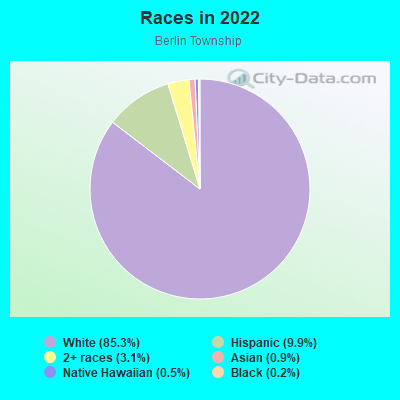
- 4,58385.3%White
- 5329.9%Hispanic or Latino
- 1663.1%Two or more races
- 480.9%Asian
- 270.5%Native Hawaiian and Other
Pacific Islander - 120.2%Black
- 40.07%American Indian
Distribution of median household income
![Distribution of median household income]()
- 117Less than $10,000
- 129$10,000 to $19,999
- 364$20,000 to $29,999
- 134$30,000 to $39,999
- 253$40,000 to $49,999
- 173$50,000 to $59,999
- 175$60,000 to $74,999
- 260$75,000 to $99,999
- 432$100,000 to $124,999
- 159$125,000 to $149,999
- 198$150,000 to $199,999
- 62$200,000 or more

Distribution of owner-occupied house/condo value
![Distribution of owner-occupied house/condo value]()
- 370Less than $50,000
- 286$50,000 to $99,999
- 262$100,000 to $149,999
- 492$150,000 to $199,999
- 271$200,000 to $249,999
- 235$250,000 to $299,999
- 295$300,000 to $399,999
- 143$400,000 to $499,999
- 45$500,000 to $749,999
- 23$750,000 to $999,999
- 185$1,000,000 or more

Distribution of rent paid by renters
![Distribution of rent paid by renters]()
- 53$300 to $399
- 655$400 to $499
- 129$500 to $599
- 76$600 to $699
- 124$700 to $799
- 147$800 to $899
- 150$900 to $999
- 114$1,000 to $1,249
- 127$1,250 to $1,499
- 47$1,500 to $1,999

| Males: | 2,649 |
| Females: | 2,595 |
Males:
| This neighborhood: | 45.9 years |
| Whole city: | 26.8 years |
| This neighborhood: | 49.3 years |
| Whole city: | 34.1 years |
Average household size:
| Berlin Township: | 2.4 people |
| Berlin Heights: | 3.0 people |
Percentage of family households:
| Berlin Township: | 39.0% |
| Berlin Heights: | 59.5% |
| Here: | 54.3% |
| Berlin Heights: | 58.3% |
Percentage of married-couple families with children (among all households):
| Berlin Township: | 42.1% |
| Berlin Heights: | 24.9% |
Percentage of single-mother households (among all households):
| Berlin Township: | 7.4% |
| Berlin Heights: | 1.7% |
Percentage of never married males 15 years old and over:
Percentage of never married females 15 years old and over:
| Berlin Township: | 15.2% |
| Berlin Heights: | 16.0% |
Percentage of never married females 15 years old and over:
| Berlin Township: | 5.1% |
| village: | 10.6% |
Percentage of people that speak English not well or not at all:
| Berlin Township: | 0.2% |
| Berlin Heights: | 0.0% |
Percentage of people born in this state:
Percentage of people born in another U.S. state:
Percentage of native residents but born outside the U.S.:
Percentage of foreign born residents:
| Here: | 78.7% |
| Berlin Heights: | 80.2% |
Percentage of people born in another U.S. state:
| Berlin Township: | 18.7% |
| Berlin Heights: | 17.9% |
Percentage of native residents but born outside the U.S.:
| Here: | 1.5% |
| village: | 0.7% |
Percentage of foreign born residents:
| Here: | 1.2% |
| Berlin Heights: | 1.2% |
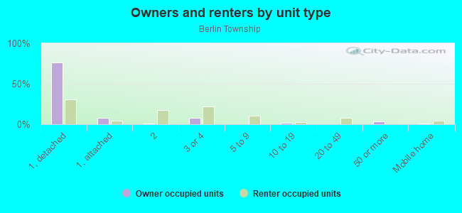
Owner-occupied
Renter-occupied

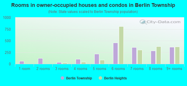
- Rooms in owner-occupied houses and condos in Berlin Township
- 611 room
- 1212 rooms
- 403 rooms
- 1064 rooms
- 2155 rooms
- 4586 rooms
- 3617 rooms
- 2838 rooms
- 3669+ rooms
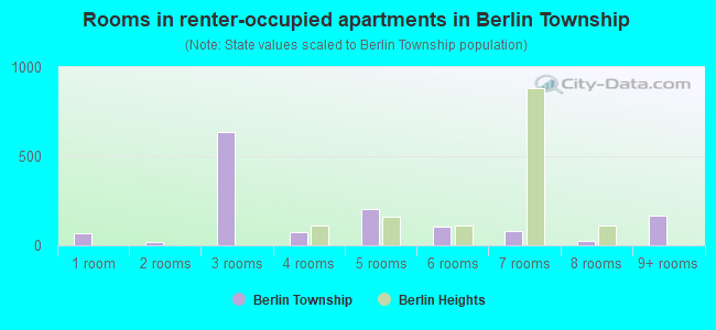
- Rooms in renter-occupied apartments in Berlin Township
- 671 room
- 202 rooms
- 6363 rooms
- 714 rooms
- 2065 rooms
- 1046 rooms
- 827 rooms
- 238 rooms
- 1679+ rooms
Owner-occupied
Renter-occupied
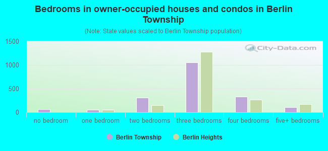
- Bedrooms in owner-occupied houses and condos in Berlin Township
- 62no bedroom
- 481 bedroom
- 3102 bedrooms
- 1,0543 bedrooms
- 3354 bedrooms
- 1075+ bedrooms
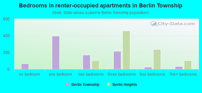
- Bedrooms in renter-occupied apartments in Berlin Township
- 67no bedroom
- 3951 bedroom
- 1702 bedrooms
- 2163 bedrooms
- 264 bedrooms
- 335+ bedrooms
Average number of cars or other vehicles available in houses/condos:
Average number of cars or other vehicles available in apartments:
| This neighborhood: | 2.2 |
| Berlin Heights: | 2.6 |
Average number of cars or other vehicles available in apartments:
| Here: | 1.7 |
| village: | 1.5 |
Percentage of units with a mortgage:
| Berlin Township: | 56.5% |
| Berlin Heights: | 65.1% |
Average estimated value of detached houses in 2022 (92.5% of all units):
| Berlin Township: | $231,365 |
| Berlin Heights: | $200,399 |
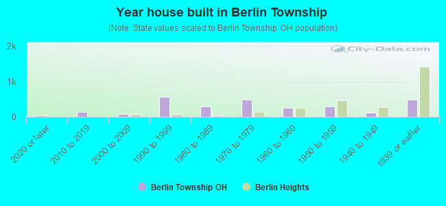
- Year house built in Berlin Township
- 322020 or later
- 1312010 to 2019
- 872000 to 2009
- 5551990 to 1999
- 2921980 to 1989
- 4851970 to 1979
- 2461960 to 1969
- 2951950 to 1959
- 1261940 to 1949
- 4951939 or earlier
Travel time to work (commute)
![Travel time to work (commute)]()
- 180Less than 5 minutes
- 1285 to 9 minutes
- 18510 to 14 minutes
- 36215 to 19 minutes
- 23320 to 24 minutes
- 29725 to 29 minutes
- 24230 to 34 minutes
- 8235 to 39 minutes
- 19440 to 44 minutes
- 11545 to 59 minutes
- 16360 to 89 minutes
- 2490 or more minutes

Means of transportation to work
![Means of transportation to work]()
- 89.1%1,949Drove a car alone
- 4.7%102Carpooled
- 1.7%37Bus
- 0.8%18Light rail, streetcar or trolley
- 0.1%3Motorcycle
- 6.3%137Walked
- 0.5%11Other means
- 4.6%100Worked at home

Time leaving home to go to work
![Time leaving home to go to work]()
- 12012:00 a.m. to 4:59 a.m.
- 1515:00 a.m. to 5:29 a.m.
- 535:30 a.m. to 5:59 a.m.
- 1086:00 a.m. to 6:29 a.m.
- 2186:30 a.m. to 6:59 a.m.
- 5057:00 a.m. to 7:29 a.m.
- 2087:30 a.m. to 7:59 a.m.
- 2148:00 a.m. to 8:29 a.m.
- 1638:30 a.m. to 8:59 a.m.
- 839:00 a.m. to 9:59 a.m.
- 7910:00 a.m. to 10:59 a.m.
- 2911:00 a.m. to 11:59 a.m.
- 19712:00 p.m. to 3:59 p.m.
- 1284:00 p.m. to 11:59 p.m.

Occupations of males:
- Percentage of males in management occupations (except farmers):
Here: 11.3% village: 14.4%
- Percentage of males in business and financial operations occupations:
Here: 1.7% village: 0.0%
- Percentage of males in architecture and engineering occupations:
Here: 3.5% village: 4.0%
- Percentage of males in community and social services occupations:
Here: 1.0% village: 0.0%
- Percentage of males in education, training, and library occupations:
Here: 4.1% village: 5.7%
- Percentage of males in arts, design, entertainment, sports, and media occupations:
Here: 1.0% village: 0.0%
- Percentage of males in healthcare practitioners and technical occupations:
Here: 3.9% village: 6.3%
- Percentage of males in service occupations:
Here: 8.2% village: 10.3%
- Percentage of males in sales and office occupations:
Here: 8.8% village: 3.4%
- Percentage of males in farming, fishing, and forestry occupations:
Here: 3.5% village: 1.1%
- Percentage of males in construction, extraction, and maintenance occupations:
Here: 15.9% village: 5.7%
- Percentage of males in production occupations:
Here: 22.8% village: 9.8%
- Percentage of males in transportation occupations:
Here: 5.8% village: 15.5%
- Percentage of males in material moving occupations:
Here: 4.9% village: 5.7%
Occupations of females:
- Percentage of females in management occupations (except farmers):
Here: 11.3% village: 14.4%
- Percentage of females in business and financial operations occupations:
Here: 1.7% village: 3.4%
- Percentage of females in legal occupations:
Here: 2.2% village: 0.0%
- Percentage of females in education, training, and library occupations:
Here: 9.5% village: 5.5%
- Percentage of females in healthcare practitioners and technical occupations:
Here: 16.2% village: 13.7%
- Percentage of females in service occupations:
Here: 11.8% village: 27.4%
- Percentage of females in sales and office occupations:
Here: 41.3% village: 26.0%
- Percentage of females in production occupations:
Here: 3.4% village: 6.8%
Percentage of people 16-64 in Armed Forces:
| Berlin Township: | 0.0% |
| Berlin Heights: | 0.0% |
Education in this neighborhood (subdivision or community):
- Percentage of people 3 years and older in K-12 schools:
Berlin Township: 17.9% Berlin Heights: 22.0%
- Percentage of people 3 years and older in undergraduate colleges:
Berlin Township: 6.0% Berlin Heights: 3.5%
- Percentage of people 3 years and older in grad. or professional schools:
Berlin Township: 3.7% Berlin Heights: 0.0%
- Percentage of students K-12 enrolled in private schools:
Berlin Township: 301.2% Berlin Heights: 1.3%
Percentage of population below poverty level:
| Berlin Township: | 9.3% |
| Berlin Heights: | 7.6% |
Median year owner moved in (as recorded in 2022):
| Berlin Township: | 2004 |
| Berlin Heights: | 2008 |
Percentage of married-couple families with both working:
| Berlin Township: | 69.7% |
| Berlin Heights: | 72.7% |
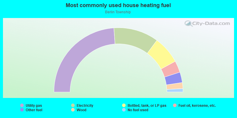
- 47.7%Utility gas
- 22.5%Electricity
- 13.9%Bottled, tank, or LP gas
- 5.8%Fuel oil, kerosene, etc.
- 5.3%Other fuel
- 3.0%Wood
- 1.7%No fuel used
Limited-access highways (interstate or state) in this neighborhood:
Ohio Tpke (I- 90, I- 80)
Length: 11.70 miles
Direction: E-W
Direction: E-W
Highways in this neighborhood:
State Rte 2
Length: 8.71 miles
Direction: E-W
Direction: E-W
US Rte 6 (Cleveland Rd E, US Hwy 6)
Length: 3.86 miles
Directions: E-W, SE-NW
Address range: 1600 to 4575
Directions: E-W, SE-NW
Address range: 1600 to 4575
State Rte 113 E (State Rte 113)
Length: 3.54 miles
Direction: E-W
Address range: 3900 to 6899
Direction: E-W
Address range: 3900 to 6899
State Rte 113 E (Edison Hwy E, Edison Hwy)
Length: 2.93 miles
Directions: E-W, SW-NE
Address range: 6909 to 9598
Directions: E-W, SW-NE
Address range: 6909 to 9598
State Rte 61 N (State Rte 61 E, State Rte 61)
Length: 2.06 miles
Directions: E-W, SW-NE
Address range: 12000 to 14699
Directions: E-W, SW-NE
Address range: 12000 to 14699
South St (State Rte 61, State Rte 61 N)
Length: 0.64 miles
Direction: N-S
Address range: 1 to 199
Direction: N-S
Address range: 1 to 199
State Rte 61 N (Lake St, State Rte 61)
Length: 0.45 miles
Direction: N-S
Address range: 1 to 98
Direction: N-S
Address range: 1 to 98
Roads and streets:
Mason Rd E (Co Hwy 13, Mason Rd)
Length: 6.01 miles
Directions: E-W, SW-NE
Address range: 4901 to 9301
Directions: E-W, SW-NE
Address range: 4901 to 9301
Berlin Rd (Co Hwy 132)
Length: 5.68 miles
Directions: E-W, N-S, SE-NW, SW-NE
Address range: 2 to 13299
Directions: E-W, N-S, SE-NW, SW-NE
Address range: 2 to 13299
Co Hwy 58 (Ceylon Rd)
Length: 5.38 miles
Directions: N-S, SE-NW
Address range: 7000 to 14099
Directions: N-S, SE-NW
Address range: 7000 to 14099
Co Hwy 14 (Darrow Rd)
Length: 4.16 miles
Direction: E-W
Address range: 5900 to 9199
Direction: E-W
Address range: 5900 to 9199
Jeffries Rd (Co Hwy 128)
Length: 3.31 miles
Directions: E-W, N-S, SE-NW, SW-NE
Address range: 1300 to 11399
Directions: E-W, N-S, SE-NW, SW-NE
Address range: 1300 to 11399
Andress Rd (Twp Hwy 136)
Length: 3.11 miles
Direction: N-S
Address range: 10900 to 13799
Direction: N-S
Address range: 10900 to 13799
Twp Hwy 131 (Chapin Rd)
Length: 3.10 miles
Directions: N-S, SE-NW
Address range: 9900 to 12999
Directions: N-S, SE-NW
Address range: 9900 to 12999
Twp Hwy 64 (County Line Rd, Nash Rd)
Length: 2.86 miles
Direction: E-W
Address range: 2901 to 8899
Direction: E-W
Address range: 2901 to 8899
Twp Hwy 133 (Bellamy Rd)
Length: 2.80 miles
Direction: N-S
Address range: 11300 to 14099
Direction: N-S
Address range: 11300 to 14099
Twp Hwy 130 (Arlington Rd)
Length: 2.72 miles
Directions: N-S, SE-NW
Address range: 11600 to 13899
Directions: N-S, SE-NW
Address range: 11600 to 13899
Twp Hwy 80 (Smokey Rd)
Length: 2.70 miles
Directions: E-W, N-S, SE-NW
Address range: 7302 to 9399
Directions: E-W, N-S, SE-NW
Address range: 7302 to 9399
Co Hwy 129 (Barrows Rd)
Length: 2.68 miles
Directions: E-W, N-S, SW-NE
Address range: 9000 to 10699
Directions: E-W, N-S, SW-NE
Address range: 9000 to 10699
Frailey Rd (Twp Hwy 137)
Length: 2.68 miles
Directions: N-S, SW-NE
Address range: 8006 to 10999
Directions: N-S, SW-NE
Address range: 8006 to 10999
Co Hwy 17 (Main Rd)
Length: 2.24 miles
Directions: E-W, SE-NW, SW-NE
Address range: 7100 to 9515
Directions: E-W, SE-NW, SW-NE
Address range: 7100 to 9515
Hill Rd (Twp Hwy 85)
Length: 1.87 miles
Direction: E-W
Address range: 2 to 6998
Direction: E-W
Address range: 2 to 6998
Reiger Rd (Twp Hwy 89)
Length: 1.75 miles
Directions: E-W, SE-NW
Address range: 8800 to 10099
Directions: E-W, SE-NW
Address range: 8800 to 10099
Knight Rd (Twp Hwy 83)
Length: 1.63 miles
Direction: E-W
Address range: 4801 to 4998
Direction: E-W
Address range: 4801 to 4998
Twp Hwy 84 (Huff Rd)
Length: 1.62 miles
Direction: E-W
Address range: 4712 to 5599
Direction: E-W
Address range: 4712 to 5599
Cable Rd (Twp Hwy 59)
Length: 1.54 miles
Direction: N-S
Address range: 12148 to 13745
Direction: N-S
Address range: 12148 to 13745
Twp Hwy 88 (Tennant Rd)
Length: 1.41 miles
Directions: E-W, SW-NE
Address range: 5900 to 6699
Directions: E-W, SW-NE
Address range: 5900 to 6699
Twp Hwy 82 (Deehr Rd)
Length: 1.21 miles
Direction: E-W
Address range: 6201 to 7098
Direction: E-W
Address range: 6201 to 7098
Wright Rd (Twp Hwy 138)
Length: 1.18 miles
Direction: N-S
Address range: 11100 to 12498
Direction: N-S
Address range: 11100 to 12498
Twp Hwy 127 (Wikel Rd)
Length: 1.17 miles
Direction: N-S
Address range: 11603 to 12183
Direction: N-S
Address range: 11603 to 12183
Humm Rd (Twp Hwy 134)
Length: 0.96 miles
Directions: N-S, SW-NE
Address range: 10801 to 11199
Directions: N-S, SW-NE
Address range: 10801 to 11199
W Collins Rd (Twp Hwy 57)
Length: 0.94 miles
Directions: N-S, SE-NW
Address range: 12901 to 14299
Directions: N-S, SE-NW
Address range: 12901 to 14299
Driver Rd (Twp Hwy 81)
Length: 0.91 miles
Directions: E-W, SW-NE
Address range: 7300 to 7899
Directions: E-W, SW-NE
Address range: 7300 to 7899
Milliman Rd (Twp Hwy 55)
Length: 0.81 miles
Directions: E-W, N-S, SE-NW
Address range: 1101 to 14199
Directions: E-W, N-S, SE-NW
Address range: 1101 to 14199
E Main St
Length: 0.80 miles
Direction: E-W
Address range: 13 to 124
Direction: E-W
Address range: 13 to 124
Hahn Rd (Twp Hwy 135)
Length: 0.78 miles
Direction: N-S
Address range: 7638 to 8099
Direction: N-S
Address range: 7638 to 8099
Collins Rd (Twp Hwy 57)
Length: 0.43 miles
Directions: N-S, SE-NW
Address range: 12900 to 13299
Directions: N-S, SE-NW
Address range: 12900 to 13299
W Main St
Length: 0.42 miles
Direction: E-W
Address range: 1 to 60
Direction: E-W
Address range: 1 to 60
Center St
Length: 0.41 miles
Directions: E-W, N-S, SW-NE
Address range: 1 to 199
Directions: E-W, N-S, SW-NE
Address range: 1 to 199
W Old Lake Rd
Length: 0.37 miles
Direction: E-W
Address range: 2300 to 2599
Direction: E-W
Address range: 2300 to 2599
Heron Dr
Length: 0.28 miles
Directions: E-W, N-S, SE-NW, SW-NE
Address range: 500 to 899
Directions: E-W, N-S, SE-NW, SW-NE
Address range: 500 to 899
Mechanic St
Length: 0.28 miles
Directions: E-W, SW-NE
Address range: 1 to 99
Directions: E-W, SW-NE
Address range: 1 to 99
S Depot St
Length: 0.27 miles
Direction: E-W
Address range: 7216 to 7414
Direction: E-W
Address range: 7216 to 7414
Edge Dr
Length: 0.24 miles
Directions: E-W, N-S, SE-NW, SW-NE
Directions: E-W, N-S, SE-NW, SW-NE
Hartley Bch
Length: 0.23 miles
Directions: E-W, N-S, SE-NW, SW-NE
Address range: 1 to 1099
Directions: E-W, N-S, SE-NW, SW-NE
Address range: 1 to 1099
Gary Dr
Length: 0.23 miles
Directions: E-W, N-S
Address range: 1 to 999
Directions: E-W, N-S
Address range: 1 to 999
Sunrise Ridge
Length: 0.23 miles
Directions: E-W, N-S, SW-NE
Directions: E-W, N-S, SW-NE
Judson Dr
Length: 0.22 miles
Directions: E-W, N-S, SE-NW, SW-NE
Address range: 1804 to 1899
Directions: E-W, N-S, SE-NW, SW-NE
Address range: 1804 to 1899
N Depot St
Length: 0.22 miles
Direction: E-W
Address range: 7400 to 7999
Direction: E-W
Address range: 7400 to 7999
Kamm Farms Dr
Length: 0.22 miles
Directions: E-W, N-S
Directions: E-W, N-S
Colony Ln
Length: 0.22 miles
Directions: E-W, N-S, SE-NW
Address range: 2301 to 2509
Directions: E-W, N-S, SE-NW
Address range: 2301 to 2509
Lee Dr
Length: 0.19 miles
Directions: E-W, N-S
Address range: 900 to 999
Directions: E-W, N-S
Address range: 900 to 999
Mary Ann Dr
Length: 0.17 miles
Directions: E-W, N-S, SW-NE
Address range: 600 to 699
Directions: E-W, N-S, SW-NE
Address range: 600 to 699
Mill St
Length: 0.17 miles
Direction: SE-NW
Address range: 1 to 99
Direction: SE-NW
Address range: 1 to 99
Co Hwy 199 (Old Lake Rd, Ceylon Rd)
Length: 0.16 miles
Direction: N-S
Direction: N-S
E Old Lake Rd
Length: 0.16 miles
Directions: E-W, SE-NW
Address range: 4201 to 4323
Directions: E-W, SE-NW
Address range: 4201 to 4323
Sandpiper Ct
Length: 0.16 miles
Directions: E-W, N-S, SE-NW, SW-NE
Address range: 1700 to 1799
Directions: E-W, N-S, SE-NW, SW-NE
Address range: 1700 to 1799
Shearwater Cir E
Length: 0.16 miles
Directions: E-W, N-S, SE-NW, SW-NE
Address range: 1700 to 1799
Directions: E-W, N-S, SE-NW, SW-NE
Address range: 1700 to 1799
Memorial Dr
Length: 0.16 miles
Direction: N-S
Address range: 1 to 34
Direction: N-S
Address range: 1 to 34
Thorpe Rd
Length: 0.15 miles
Directions: E-W, N-S, SW-NE
Directions: E-W, N-S, SW-NE
Mirheath Dr
Length: 0.15 miles
Direction: N-S
Address range: 1300 to 1417
Direction: N-S
Address range: 1300 to 1417
Shearwater Cir W
Length: 0.14 miles
Directions: E-W, N-S, SE-NW, SW-NE
Address range: 1700 to 1799
Directions: E-W, N-S, SE-NW, SW-NE
Address range: 1700 to 1799
Nicholas Dr
Length: 0.11 miles
Direction: N-S
Address range: 243 to 299
Direction: N-S
Address range: 243 to 299
Freeman Ln
Length: 0.11 miles
Direction: N-S
Address range: 7301 to 7499
Direction: N-S
Address range: 7301 to 7499
Snowy Egret Dr
Length: 0.11 miles
Directions: E-W, SW-NE
Address range: 500 to 599
Directions: E-W, SW-NE
Address range: 500 to 599
1st St
Length: 0.10 miles
Direction: E-W
Direction: E-W
Jeanie Dr
Length: 0.10 miles
Direction: N-S
Address range: 1 to 499
Direction: N-S
Address range: 1 to 499
3rd St
Length: 0.10 miles
Direction: E-W
Direction: E-W
2nd St
Length: 0.10 miles
Direction: E-W
Direction: E-W
4th St
Length: 0.10 miles
Direction: E-W
Direction: E-W
Loon Ln
Length: 0.10 miles
Directions: E-W, SW-NE
Address range: 500 to 599
Directions: E-W, SW-NE
Address range: 500 to 599
5th St
Length: 0.10 miles
Direction: E-W
Direction: E-W
6th St
Length: 0.10 miles
Direction: E-W
Address range: 1 to 5
Direction: E-W
Address range: 1 to 5
Whippoorwill Ln (Wippoorwill Dr)
Length: 0.10 miles
Direction: E-W
Address range: 2 to 11
Direction: E-W
Address range: 2 to 11
Green Teal Pl
Length: 0.09 miles
Directions: E-W, N-S, SE-NW, SW-NE
Address range: 500 to 599
Directions: E-W, N-S, SE-NW, SW-NE
Address range: 500 to 599
Elm St
Length: 0.09 miles
Direction: E-W
Address range: 7100 to 7299
Direction: E-W
Address range: 7100 to 7299
Valley View Dr (Valleyview St)
Length: 0.09 miles
Directions: E-W, N-S, SE-NW, SW-NE
Address range: 1 to 11
Directions: E-W, N-S, SE-NW, SW-NE
Address range: 1 to 11
Stan Dr
Length: 0.08 miles
Direction: N-S
Address range: 500 to 599
Direction: N-S
Address range: 500 to 599
Lands End Rd
Length: 0.07 miles
Directions: E-W, N-S, SE-NW, SW-NE
Address range: 1601 to 1717
Directions: E-W, N-S, SE-NW, SW-NE
Address range: 1601 to 1717
By-The-Shores
Length: 0.06 miles
Direction: SW-NE
Direction: SW-NE
Mallard Cir
Length: 0.05 miles
Directions: E-W, N-S, SE-NW, SW-NE
Directions: E-W, N-S, SE-NW, SW-NE
Merganzer Dr
Length: 0.05 miles
Direction: E-W
Address range: 500 to 599
Direction: E-W
Address range: 500 to 599
Oberlein Beach Ln
Length: 0.04 miles
Directions: N-S, SW-NE
Directions: N-S, SW-NE
Hartley
Length: 0.04 miles
Direction: SW-NE
Address range: 1801 to 1803
Direction: SW-NE
Address range: 1801 to 1803
Railroad features:
Norfolk and Western Rlwy
Length: 7.41 miles
Directions: E-W, SW-NE
Directions: E-W, SW-NE
Conrail RR
Length: 3.32 miles
Directions: E-W, SE-NW
Directions: E-W, SE-NW
Other features:
Old Woman Crk
Length: 11.91 miles
Directions: E-W, N-S, SE-NW, SW-NE
Directions: E-W, N-S, SE-NW, SW-NE
Cranberry Crk
Length: 4.04 miles
Directions: E-W, N-S, SE-NW, SW-NE
Directions: E-W, N-S, SE-NW, SW-NE
Roads and streets:
Twp Hwy 64 (Nash Rd, County Line Rd)
Length: 2.86 miles
Direction: E-W
Address range: 2901 to 8899
Direction: E-W
Address range: 2901 to 8899
Twp Hwy 55 (Milliman Rd)
Length: 0.47 miles
Direction: E-W
Address range: 1101 to 14199
Direction: E-W
Address range: 1101 to 14199
Twp Hwy 55
Length: 0.01 miles
Direction: E-W
Direction: E-W