King Arthur Estates (King Arthur's Estate) neighborhood in Mentor, Ohio (OH), 44060 detailed profile
Settings
X


Business Search - 14 Million verified businesses
Area: 2.461 square miles
Population: 7,884
Population density:
| King Arthur Estates (King Arthur's Estate): | 3,204 people per square mile |
| Mentor: | 1,767 people per square mile |

- 7,35188.8%White
- 5186.3%Asian
- 1501.8%Two or more races
- 1141.4%Some other race
- 871.1%Hispanic or Latino
- 550.7%Black
- 60.07%American Indian

Median household income in 2022:
| King Arthur Estates (King Arthur's Estate): | $83,335 |
| Mentor: | $84,503 |
Distribution of median household income
![Distribution of median household income]()
- 79Less than $10,000
- 510$10,000 to $19,999
- 167$20,000 to $29,999
- 313$30,000 to $39,999
- 809$40,000 to $49,999
- 299$50,000 to $59,999
- 164$60,000 to $74,999
- 1,083$75,000 to $99,999
- 551$100,000 to $124,999
- 137$125,000 to $149,999
- 344$150,000 to $199,999
- 19$200,000 or more

Distribution of owner-occupied house/condo value
![Distribution of owner-occupied house/condo value]()
- 714Less than $50,000
- 359$50,000 to $99,999
- 545$100,000 to $149,999
- 945$150,000 to $199,999
- 1,621$200,000 to $249,999
- 238$250,000 to $299,999
- 155$300,000 to $399,999
- 156$400,000 to $499,999
- 179$500,000 to $749,999
- 102$750,000 to $999,999
- 80$1,000,000 or more

Distribution of rent paid by renters
![Distribution of rent paid by renters]()
- 26Less than $100
- 41$300 to $399
- 170$400 to $499
- 158$500 to $599
- 145$600 to $699
- 674$700 to $799
- 55$800 to $899
- 288$900 to $999
- 139$1,000 to $1,249
- 78$1,250 to $1,499
- 70$1,500 to $1,999
- 7$2,000 or more

| Males: | 3,226 |
| Females: | 4,657 |
Males:
| This neighborhood: | 43.2 years |
| Whole city: | 44.4 years |
| This neighborhood: | 50.2 years |
| Whole city: | 47.7 years |
Average household size:
| King Arthur Estates (King Arthur's Estate): | 2.3 people |
| Mentor: | 2.4 people |
Percentage of family households:
| King Arthur Estates (King Arthur's Estate): | 27.8% |
| Mentor: | 42.8% |
| Here: | 40.6% |
| Mentor: | 54.0% |
Percentage of married-couple families with children (among all households):
| King Arthur Estates (King Arthur's Estate): | 46.4% |
| Mentor: | 33.6% |
Percentage of single-mother households (among all households):
| King Arthur Estates (King Arthur's Estate): | 8.4% |
| Mentor: | 5.7% |
Percentage of never married males 15 years old and over:
Percentage of never married females 15 years old and over:
| King Arthur Estates (King Arthur's Estate): | 6.8% |
| Mentor: | 15.4% |
Percentage of never married females 15 years old and over:
| King Arthur Estates (King Arthur's Estate): | 11.8% |
| city: | 11.5% |
Percentage of people that speak English not well or not at all:
| King Arthur Estates (King Arthur's Estate): | 3.2% |
| Mentor: | 1.5% |
Percentage of people born in this state:
Percentage of people born in another U.S. state:
Percentage of native residents but born outside the U.S.:
Percentage of foreign born residents:
| Here: | 80.6% |
| Mentor: | 76.6% |
Percentage of people born in another U.S. state:
| King Arthur Estates (King Arthur's Estate): | 14.1% |
| Mentor: | 16.7% |
Percentage of native residents but born outside the U.S.:
| Here: | 0.4% |
| city: | 0.5% |
Percentage of foreign born residents:
| Here: | 5.0% |
| Mentor: | 6.3% |

Owner-occupied
Renter-occupied


- Rooms in owner-occupied houses and condos in King Arthur Estates <
> - 01 room
- 02 rooms
- 503 rooms
- 894 rooms
- 7145 rooms
- 3396 rooms
- 5077 rooms
- 1,2558 rooms
- 3709+ rooms
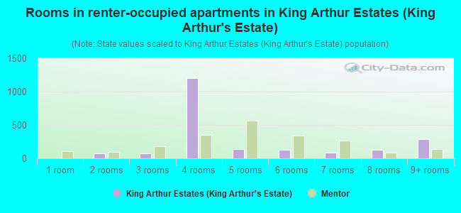
- Rooms in renter-occupied apartments in King Arthur Estates <
> - 01 room
- 752 rooms
- 783 rooms
- 1,2064 rooms
- 1365 rooms
- 1256 rooms
- 887 rooms
- 1318 rooms
- 2879+ rooms
Owner-occupied
Renter-occupied

- Bedrooms in owner-occupied houses and condos in King Arthur Estates <
> - 0no bedroom
- 01 bedroom
- 1382 bedrooms
- 1,8093 bedrooms
- 1,3214 bedrooms
- 1425+ bedrooms

- Bedrooms in renter-occupied apartments in King Arthur Estates <
> - 0no bedroom
- 6681 bedroom
- 1,0812 bedrooms
- 4193 bedrooms
- 834 bedrooms
- 1315+ bedrooms
Average number of cars or other vehicles available in houses/condos:
Average number of cars or other vehicles available in apartments:
| This neighborhood: | 1.8 |
| Mentor: | 2.0 |
Average number of cars or other vehicles available in apartments:
| Here: | 5.6 |
| city: | 1.4 |
Percentage of units with a mortgage:
| King Arthur Estates (King Arthur's Estate): | 42.9% |
| Mentor: | 58.2% |
Average estimated value of detached houses in 2022 (99.6% of all units):
| King Arthur Estates (King Arthur's Estate): | $223,159 |
| Mentor: | $249,987 |

- Year house built in King Arthur Estates <
> - 702020 or later
- 1402010 to 2019
- 2682000 to 2009
- 1061990 to 1999
- 6961980 to 1989
- 7591970 to 1979
- 1,7721960 to 1969
- 7041950 to 1959
- 2781940 to 1949
- 851939 or earlier

City-data.com crime index for city in 2020 (higher means more crime):
| City: | 103.9 |
| U.S. average: | 219.5 |
Travel time to work (commute)
![Travel time to work (commute)]()
- 18Less than 5 minutes
- 2895 to 9 minutes
- 60310 to 14 minutes
- 54515 to 19 minutes
- 42620 to 24 minutes
- 19025 to 29 minutes
- 21630 to 34 minutes
- 9235 to 39 minutes
- 10140 to 44 minutes
- 34845 to 59 minutes
- 8960 to 89 minutes
- 1190 or more minutes

Means of transportation to work
![Means of transportation to work]()
- 86.4%3,317Drove a car alone
- 11.0%421Carpooled
- 0.5%19Bus
- 0.5%18Bicycle
- 0.9%36Walked
- 0.7%26Other means
- 2.6%98Worked at home

Time leaving home to go to work
![Time leaving home to go to work]()
- 9112:00 a.m. to 4:59 a.m.
- 1385:00 a.m. to 5:29 a.m.
- 985:30 a.m. to 5:59 a.m.
- 1796:00 a.m. to 6:29 a.m.
- 2896:30 a.m. to 6:59 a.m.
- 5657:00 a.m. to 7:29 a.m.
- 4887:30 a.m. to 7:59 a.m.
- 2618:00 a.m. to 8:29 a.m.
- 788:30 a.m. to 8:59 a.m.
- 1179:00 a.m. to 9:59 a.m.
- 5110:00 a.m. to 10:59 a.m.
- 12111:00 a.m. to 11:59 a.m.
- 18012:00 p.m. to 3:59 p.m.
- 374:00 p.m. to 11:59 p.m.

Occupations of males:
- Percentage of males in management occupations (except farmers):
Here: 28.9% city: 15.3%
- Percentage of males in business and financial operations occupations:
Here: 6.1% city: 4.8%
- Percentage of males in sales and office occupations:
Here: 9.9% city: 16.3%
- Percentage of males in construction, extraction, and maintenance occupations:
Here: 46.1% city: 7.1%
- Percentage of males in production occupations:
Here: 6.3% city: 13.5%
Occupations of females:
- Percentage of females in business and financial operations occupations:
Here: 12.5% city: 8.3%
- Percentage of females in community and social services occupations:
Here: 8.0% city: 1.5%
- Percentage of females in arts, design, entertainment, sports, and media occupations:
Here: 9.4% city: 1.1%
- Percentage of females in healthcare practitioners and technical occupations:
Here: 7.8% city: 13.4%
- Percentage of females in service occupations:
Here: 8.7% city: 18.0%
- Percentage of females in sales and office occupations:
Here: 46.0% city: 27.6%
- Percentage of females in production occupations:
Here: 6.6% city: 4.6%
- Percentage of females in material moving occupations:
Here: 4.1% city: 1.0%
Percentage of people 16-64 in Armed Forces:
| King Arthur Estates (King Arthur's Estate): | 0.0% |
| Mentor: | 0.0% |
Education in this neighborhood (subdivision or community):
- Percentage of people 3 years and older in K-12 schools:
King Arthur Estates (King Arthur's Estate): 27.1% Mentor: 14.6%
- Percentage of people 3 years and older in undergraduate colleges:
King Arthur Estates (King Arthur's Estate): 3.7% Mentor: 4.2%
- Percentage of people 3 years and older in grad. or professional schools:
King Arthur Estates (King Arthur's Estate): 2.8% Mentor: 0.6%
- Percentage of students K-12 enrolled in private schools:
King Arthur Estates (King Arthur's Estate): 55.8% Mentor: 14.4%
Percentage of population below poverty level:
| King Arthur Estates (King Arthur's Estate): | 9.7% |
| Mentor: | 4.8% |
Median year owner moved in (as recorded in 2022):
| King Arthur Estates (King Arthur's Estate): | 2003 |
| Mentor: | 2004 |
Percentage of married-couple families with both working:
| King Arthur Estates (King Arthur's Estate): | 143.2% |
| Mentor: | 78.5% |

- 74.9%Utility gas
- 12.6%Electricity
- 4.9%Wood
- 2.2%Fuel oil, kerosene, etc.
- 2.1%Bottled, tank, or LP gas
- 1.9%No fuel used
- 1.3%Other fuel
Highways in this neighborhood:
Lakeland Fwy (State Rte 2)
Length: 2.73 miles
Direction: SW-NE
Direction: SW-NE
State Rte 306 (Reynolds Rd)
Length: 2.44 miles
Directions: E-W, N-S
Address range: 6333 to 7622
Directions: E-W, N-S
Address range: 6333 to 7622
State Rte 283 (Lake Shore Blvd)
Length: 0.52 miles
Directions: E-W, SW-NE
Address range: 7576 to 7798
Directions: E-W, SW-NE
Address range: 7576 to 7798
Munson Rd (State Rte 615, State Rte 283)
Length: 0.51 miles
Direction: E-W
Address range: 7755 to 7998
Direction: E-W
Address range: 7755 to 7998
Roads and streets:
Dawson Blvd
Length: 1.54 miles
Directions: E-W, N-S, SE-NW, SW-NE
Address range: 6149 to 6516
Directions: E-W, N-S, SE-NW, SW-NE
Address range: 6149 to 6516
Bellflower Rd
Length: 1.49 miles
Directions: E-W, SW-NE
Address range: 7300 to 7985
Directions: E-W, SW-NE
Address range: 7300 to 7985
Brooks Blvd
Length: 1.47 miles
Directions: E-W, N-S, SE-NW, SW-NE
Address range: 6161 to 6538
Directions: E-W, N-S, SE-NW, SW-NE
Address range: 6161 to 6538
Ohio St
Length: 1.32 miles
Directions: E-W, N-S, SW-NE
Address range: 6901 to 7747
Directions: E-W, N-S, SW-NE
Address range: 6901 to 7747
Mentor Park Blvd
Length: 1.02 miles
Directions: E-W, N-S, SE-NW, SW-NE
Address range: 6122 to 6599
Directions: E-W, N-S, SE-NW, SW-NE
Address range: 6122 to 6599
Meadowbrook Dr
Length: 0.89 miles
Directions: N-S, SE-NW, SW-NE
Address range: 6100 to 6599
Directions: N-S, SE-NW, SW-NE
Address range: 6100 to 6599
Inland Shores Dr
Length: 0.76 miles
Directions: E-W, N-S, SE-NW, SW-NE
Address range: 6200 to 6550
Directions: E-W, N-S, SE-NW, SW-NE
Address range: 6200 to 6550
Chase Dr
Length: 0.71 miles
Directions: E-W, N-S, SW-NE
Address range: 6200 to 6542
Directions: E-W, N-S, SW-NE
Address range: 6200 to 6542
Saint James Dr
Length: 0.70 miles
Directions: E-W, N-S, SE-NW, SW-NE
Address range: 7600 to 7899
Directions: E-W, N-S, SE-NW, SW-NE
Address range: 7600 to 7899
Jeremy Ave
Length: 0.69 miles
Directions: E-W, N-S, SE-NW, SW-NE
Address range: 7364 to 7699
Directions: E-W, N-S, SE-NW, SW-NE
Address range: 7364 to 7699
Champaign Dr
Length: 0.65 miles
Directions: E-W, N-S, SE-NW, SW-NE
Address range: 7750 to 7998
Directions: E-W, N-S, SE-NW, SW-NE
Address range: 7750 to 7998
Meldon Dr
Length: 0.64 miles
Directions: N-S, SE-NW
Address range: 6116 to 6458
Directions: N-S, SE-NW
Address range: 6116 to 6458
Hayes Blvd
Length: 0.63 miles
Direction: N-S
Address range: 7031 to 7371
Direction: N-S
Address range: 7031 to 7371
Carolyn Dr
Length: 0.62 miles
Directions: N-S, SW-NE
Address range: 6117 to 6439
Directions: N-S, SW-NE
Address range: 6117 to 6439
Weatherby Dr
Length: 0.61 miles
Directions: E-W, N-S, SE-NW, SW-NE
Address range: 6752 to 6999
Directions: E-W, N-S, SE-NW, SW-NE
Address range: 6752 to 6999
Texas Ave
Length: 0.57 miles
Direction: E-W
Address range: 7369 to 7599
Direction: E-W
Address range: 7369 to 7599
Hawk Ave
Length: 0.57 miles
Direction: E-W
Address range: 7363 to 7599
Direction: E-W
Address range: 7363 to 7599
Carter Blvd
Length: 0.51 miles
Directions: E-W, N-S, SE-NW, SW-NE
Address range: 6300 to 6599
Directions: E-W, N-S, SE-NW, SW-NE
Address range: 6300 to 6599
Rutland Dr
Length: 0.47 miles
Directions: E-W, N-S, SE-NW, SW-NE
Address range: 7700 to 7899
Directions: E-W, N-S, SE-NW, SW-NE
Address range: 7700 to 7899
Silvermound Dr
Length: 0.47 miles
Directions: E-W, N-S, SE-NW
Address range: 6600 to 6799
Directions: E-W, N-S, SE-NW
Address range: 6600 to 6799
Clearair Dr
Length: 0.43 miles
Direction: N-S
Address range: 6300 to 6548
Direction: N-S
Address range: 6300 to 6548
Palmerston Dr
Length: 0.43 miles
Directions: E-W, N-S, SW-NE
Address range: 6700 to 7680
Directions: E-W, N-S, SW-NE
Address range: 6700 to 7680
Essex Dr
Length: 0.40 miles
Directions: E-W, SW-NE
Address range: 7382 to 7520
Directions: E-W, SW-NE
Address range: 7382 to 7520
Durham Ct
Length: 0.38 miles
Directions: E-W, N-S, SE-NW, SW-NE
Address range: 6500 to 6799
Directions: E-W, N-S, SE-NW, SW-NE
Address range: 6500 to 6799
N Palmerstone Dr
Length: 0.36 miles
Directions: E-W, N-S, SE-NW
Address range: 6600 to 6799
Directions: E-W, N-S, SE-NW
Address range: 6600 to 6799
Hoover Dr
Length: 0.36 miles
Directions: E-W, N-S, SW-NE
Address range: 7000 to 7899
Directions: E-W, N-S, SW-NE
Address range: 7000 to 7899
Raymond Dr
Length: 0.34 miles
Directions: E-W, SW-NE
Address range: 6316 to 7799
Directions: E-W, SW-NE
Address range: 6316 to 7799
Taft St
Length: 0.34 miles
Directions: N-S, SW-NE
Address range: 7170 to 7399
Directions: N-S, SW-NE
Address range: 7170 to 7399
Georgetown Dr
Length: 0.33 miles
Directions: E-W, N-S, SE-NW, SW-NE
Address range: 6700 to 6999
Directions: E-W, N-S, SE-NW, SW-NE
Address range: 6700 to 6999
Faye Ln
Length: 0.32 miles
Direction: E-W
Address range: 7355 to 7461
Direction: E-W
Address range: 7355 to 7461
Ford Rd (Ford Dr)
Length: 0.32 miles
Direction: E-W
Address range: 7344 to 7499
Direction: E-W
Address range: 7344 to 7499
Dunbar Dr
Length: 0.31 miles
Directions: N-S, SE-NW, SW-NE
Address range: 6159 to 6343
Directions: N-S, SE-NW, SW-NE
Address range: 6159 to 6343
Spring Blossom Dr
Length: 0.30 miles
Directions: E-W, N-S, SE-NW
Address range: 7400 to 7599
Directions: E-W, N-S, SE-NW
Address range: 7400 to 7599
William St
Length: 0.30 miles
Direction: E-W
Address range: 7700 to 7799
Direction: E-W
Address range: 7700 to 7799
Churchill Sq
Length: 0.29 miles
Direction: E-W
Address range: 7300 to 7507
Direction: E-W
Address range: 7300 to 7507
Aster Dr
Length: 0.29 miles
Directions: E-W, SE-NW, SW-NE
Address range: 7600 to 7799
Directions: E-W, SE-NW, SW-NE
Address range: 7600 to 7799
S Chestnut Commons Dr
Length: 0.29 miles
Directions: E-W, N-S, SW-NE
Address range: 7300 to 7433
Directions: E-W, N-S, SW-NE
Address range: 7300 to 7433
Jasani Ct
Length: 0.29 miles
Direction: E-W
Address range: 7300 to 7599
Direction: E-W
Address range: 7300 to 7599
Truman Ct
Length: 0.29 miles
Direction: E-W
Address range: 7389 to 7509
Direction: E-W
Address range: 7389 to 7509
Parkwood Rd
Length: 0.28 miles
Directions: N-S, SE-NW
Address range: 6120 to 6268
Directions: N-S, SE-NW
Address range: 6120 to 6268
Sutherland Ct
Length: 0.28 miles
Direction: N-S
Address range: 6800 to 6918
Direction: N-S
Address range: 6800 to 6918
Buchanan Ct
Length: 0.27 miles
Directions: E-W, N-S, SE-NW, SW-NE
Address range: 7000 to 7706
Directions: E-W, N-S, SE-NW, SW-NE
Address range: 7000 to 7706
Emery Cir
Length: 0.27 miles
Directions: E-W, N-S, SE-NW, SW-NE
Address range: 6100 to 7899
Directions: E-W, N-S, SE-NW, SW-NE
Address range: 6100 to 7899
W Jefferson Dr
Length: 0.27 miles
Directions: E-W, N-S, SW-NE
Address range: 7000 to 7125
Directions: E-W, N-S, SW-NE
Address range: 7000 to 7125
S Camelot Dr
Length: 0.26 miles
Directions: E-W, N-S, SE-NW
Address range: 6700 to 7977
Directions: E-W, N-S, SE-NW
Address range: 6700 to 7977
Brainard Ct
Length: 0.26 miles
Directions: E-W, N-S, SE-NW, SW-NE
Address range: 7575 to 7632
Directions: E-W, N-S, SE-NW, SW-NE
Address range: 7575 to 7632
Sycamore Rd
Length: 0.26 miles
Direction: N-S
Address range: 6463 to 6559
Direction: N-S
Address range: 6463 to 6559
Gallowae Ct
Length: 0.25 miles
Directions: E-W, N-S, SE-NW, SW-NE
Address range: 7836 to 7999
Directions: E-W, N-S, SE-NW, SW-NE
Address range: 7836 to 7999
Avon Dr
Length: 0.25 miles
Directions: E-W, N-S
Address range: 7368 to 7456
Directions: E-W, N-S
Address range: 7368 to 7456
Traymore Ct
Length: 0.25 miles
Directions: E-W, N-S, SE-NW, SW-NE
Address range: 6817 to 7006
Directions: E-W, N-S, SE-NW, SW-NE
Address range: 6817 to 7006
Grant St
Length: 0.24 miles
Direction: N-S
Address range: 7194 to 7309
Direction: N-S
Address range: 7194 to 7309
E Jefferson Dr
Length: 0.24 miles
Directions: E-W, N-S, SE-NW
Address range: 7000 to 7199
Directions: E-W, N-S, SE-NW
Address range: 7000 to 7199
Newton Dr
Length: 0.24 miles
Directions: E-W, N-S, SW-NE
Address range: 7615 to 7635
Directions: E-W, N-S, SW-NE
Address range: 7615 to 7635
N Weatherby Dr
Length: 0.23 miles
Directions: N-S, SW-NE
Address range: 6600 to 6799
Directions: N-S, SW-NE
Address range: 6600 to 6799
McKinley St
Length: 0.22 miles
Direction: E-W
Address range: 7400 to 7599
Direction: E-W
Address range: 7400 to 7599
Harding St
Length: 0.22 miles
Directions: E-W, SW-NE
Address range: 7423 to 7510
Directions: E-W, SW-NE
Address range: 7423 to 7510
Glencairn Ct
Length: 0.20 miles
Directions: E-W, N-S, SE-NW, SW-NE
Address range: 6800 to 6830
Directions: E-W, N-S, SE-NW, SW-NE
Address range: 6800 to 6830
N Chestnut Commons Dr
Length: 0.19 miles
Directions: E-W, N-S, SE-NW, SW-NE
Address range: 7355 to 7499
Directions: E-W, N-S, SE-NW, SW-NE
Address range: 7355 to 7499
Hoover Ct
Length: 0.19 miles
Directions: E-W, N-S, SE-NW, SW-NE
Address range: 7773 to 7844
Directions: E-W, N-S, SE-NW, SW-NE
Address range: 7773 to 7844
Cole Dr
Length: 0.19 miles
Directions: E-W, SW-NE
Address range: 7360 to 7437
Directions: E-W, SW-NE
Address range: 7360 to 7437
Cherry Blossom Dr
Length: 0.18 miles
Directions: N-S, SW-NE
Address range: 6800 to 6999
Directions: N-S, SW-NE
Address range: 6800 to 6999
Lupine Dr
Length: 0.18 miles
Directions: E-W, N-S, SW-NE
Address range: 7700 to 7799
Directions: E-W, N-S, SW-NE
Address range: 7700 to 7799
Duke Ct
Length: 0.17 miles
Directions: E-W, SE-NW
Address range: 7400 to 7499
Directions: E-W, SE-NW
Address range: 7400 to 7499
Ivana Ct
Length: 0.16 miles
Directions: E-W, N-S, SE-NW, SW-NE
Address range: 6500 to 6699
Directions: E-W, N-S, SE-NW, SW-NE
Address range: 6500 to 6699
Camelot Dr
Length: 0.15 miles
Directions: N-S, SW-NE
Address range: 6700 to 6799
Directions: N-S, SW-NE
Address range: 6700 to 6799
Barnaby Ln
Length: 0.15 miles
Direction: E-W
Address range: 7700 to 7899
Direction: E-W
Address range: 7700 to 7899
Chablis Ct
Length: 0.15 miles
Directions: E-W, N-S, SE-NW, SW-NE
Address range: 6800 to 6899
Directions: E-W, N-S, SE-NW, SW-NE
Address range: 6800 to 6899
Noble Ct
Length: 0.13 miles
Directions: E-W, N-S, SE-NW
Address range: 7300 to 7499
Directions: E-W, N-S, SE-NW
Address range: 7300 to 7499
Willow Run Dr
Length: 0.13 miles
Direction: E-W
Address range: 7371 to 7399
Direction: E-W
Address range: 7371 to 7399
Princeton Dr (Princeton Ct)
Length: 0.12 miles
Direction: E-W
Address range: 7450 to 7571
Direction: E-W
Address range: 7450 to 7571
Anchor Ct
Length: 0.12 miles
Directions: E-W, SW-NE
Address range: 7500 to 7699
Directions: E-W, SW-NE
Address range: 7500 to 7699
Fillmore Ct
Length: 0.12 miles
Directions: E-W, N-S, SE-NW
Address range: 7124 to 7199
Directions: E-W, N-S, SE-NW
Address range: 7124 to 7199
Oak St
Length: 0.12 miles
Direction: E-W
Address range: 7800 to 7899
Direction: E-W
Address range: 7800 to 7899
Pear Tree Ln
Length: 0.12 miles
Directions: N-S, SE-NW
Address range: 6500 to 6699
Directions: N-S, SE-NW
Address range: 6500 to 6699
Daleford Dr
Length: 0.11 miles
Directions: E-W, SW-NE
Address range: 7720 to 7799
Directions: E-W, SW-NE
Address range: 7720 to 7799
Rice Dr
Length: 0.11 miles
Direction: E-W
Direction: E-W
Cranberry Ln
Length: 0.11 miles
Directions: E-W, SE-NW
Address range: 7700 to 7899
Directions: E-W, SE-NW
Address range: 7700 to 7899
Kennedy Ct
Length: 0.10 miles
Direction: E-W
Address range: 7580 to 7613
Direction: E-W
Address range: 7580 to 7613
Duckworth Ln
Length: 0.10 miles
Directions: E-W, N-S, SE-NW
Address range: 7700 to 7799
Directions: E-W, N-S, SE-NW
Address range: 7700 to 7799
Mapledale Rd
Length: 0.10 miles
Direction: E-W
Address range: 7900 to 7999
Direction: E-W
Address range: 7900 to 7999
Longhorn Rd (Longhorn Ave)
Length: 0.09 miles
Direction: N-S
Address range: 7565 to 7581
Direction: N-S
Address range: 7565 to 7581
Vine St
Length: 0.09 miles
Directions: E-W, N-S, SW-NE
Address range: 6728 to 6788
Directions: E-W, N-S, SW-NE
Address range: 6728 to 6788
Union St
Length: 0.08 miles
Directions: E-W, SE-NW
Address range: 7700 to 7799
Directions: E-W, SE-NW
Address range: 7700 to 7799
Adams Ct
Length: 0.08 miles
Directions: E-W, N-S, SE-NW, SW-NE
Address range: 7543 to 7561
Directions: E-W, N-S, SE-NW, SW-NE
Address range: 7543 to 7561
Chestnut Commons Dr
Length: 0.07 miles
Direction: E-W
Direction: E-W
Crown Ct
Length: 0.07 miles
Directions: N-S, SW-NE
Address range: 7428 to 7459
Directions: N-S, SW-NE
Address range: 7428 to 7459
Wooster Ct
Length: 0.06 miles
Direction: N-S
Address range: 7300 to 7499
Direction: N-S
Address range: 7300 to 7499
Abby Ct
Length: 0.06 miles
Direction: N-S
Address range: 7380 to 7411
Direction: N-S
Address range: 7380 to 7411
Appleton Ct
Length: 0.06 miles
Directions: N-S, SW-NE
Address range: 6900 to 6999
Directions: N-S, SW-NE
Address range: 6900 to 6999
Vanburen Ct
Length: 0.06 miles
Directions: E-W, SE-NW
Address range: 7100 to 7113
Directions: E-W, SE-NW
Address range: 7100 to 7113
Lighthouse Ct
Length: 0.06 miles
Direction: E-W
Address range: 7500 to 7699
Direction: E-W
Address range: 7500 to 7699
Manry Ct
Length: 0.06 miles
Direction: E-W
Direction: E-W
S Durham Ct
Length: 0.06 miles
Directions: E-W, N-S, SE-NW, SW-NE
Directions: E-W, N-S, SE-NW, SW-NE
Captains Ct
Length: 0.06 miles
Direction: E-W
Address range: 7500 to 7599
Direction: E-W
Address range: 7500 to 7599
Coolidge Ct
Length: 0.06 miles
Direction: SW-NE
Address range: 7630 to 7659
Direction: SW-NE
Address range: 7630 to 7659
Portside Dr
Length: 0.06 miles
Direction: E-W
Direction: E-W
Filmore Ct
Length: 0.05 miles
Directions: E-W, N-S, SE-NW, SW-NE
Directions: E-W, N-S, SE-NW, SW-NE
Sir Roberts Ct
Length: 0.05 miles
Directions: E-W, SW-NE
Address range: 7400 to 7499
Directions: E-W, SW-NE
Address range: 7400 to 7499
Sutterland Ct
Length: 0.05 miles
Directions: E-W, N-S, SE-NW, SW-NE
Directions: E-W, N-S, SE-NW, SW-NE
Partridge Ct
Length: 0.05 miles
Direction: E-W
Address range: 7800 to 7899
Direction: E-W
Address range: 7800 to 7899
Van Buren Ct
Length: 0.05 miles
Directions: E-W, N-S, SE-NW, SW-NE
Directions: E-W, N-S, SE-NW, SW-NE
Zinnia Ct
Length: 0.05 miles
Directions: E-W, SE-NW
Address range: 6600 to 6699
Directions: E-W, SE-NW
Address range: 6600 to 6699
Monroe Ct
Length: 0.05 miles
Direction: E-W
Address range: 7800 to 7812
Direction: E-W
Address range: 7800 to 7812
Sunflower Ct
Length: 0.05 miles
Directions: E-W, SW-NE
Address range: 7600 to 7699
Directions: E-W, SW-NE
Address range: 7600 to 7699
Kingstown Ct
Length: 0.04 miles
Direction: N-S
Address range: 7392 to 7421
Direction: N-S
Address range: 7392 to 7421
Yorktown Ct
Length: 0.04 miles
Direction: N-S
Address range: 7391 to 7424
Direction: N-S
Address range: 7391 to 7424
Polk Ct
Length: 0.04 miles
Direction: SE-NW
Address range: 7000 to 7099
Direction: SE-NW
Address range: 7000 to 7099
St John Ct
Length: 0.04 miles
Directions: E-W, SW-NE
Address range: 7400 to 7499
Directions: E-W, SW-NE
Address range: 7400 to 7499
Bay Ridge Ct
Length: 0.03 miles
Direction: SE-NW
Direction: SE-NW
Other features:
Martin Ohm Crk
Length: 0.98 miles
Directions: E-W, SW-NE
Directions: E-W, SW-NE