Mercer neighborhood in Beachwood, Santa Fe, Ohio (OH), 44118, 44122 detailed profile
Settings
X


Business Search - 14 Million verified businesses
Area: 2.724 square miles
Population: 11,739
Population density:
| Mercer: | 4,310 people per square mile |
| Beachwood: | 2,622 people per square mile |

- 8,28767.1%White
- 2,08516.9%Black
- 8406.8%Hispanic or Latino
- 4894.0%Asian
- 3733.0%Two or more races
- 2171.8%Some other race
- 660.5%American Indian

Distribution of median household income
![Distribution of median household income]()
- 509Less than $10,000
- 836$10,000 to $19,999
- 917$20,000 to $29,999
- 387$30,000 to $39,999
- 461$40,000 to $49,999
- 285$50,000 to $59,999
- 448$60,000 to $74,999
- 534$75,000 to $99,999
- 684$100,000 to $124,999
- 252$125,000 to $149,999
- 647$150,000 to $199,999
- 1,361$200,000 or more

Distribution of owner-occupied house/condo value
![Distribution of owner-occupied house/condo value]()
- 2,189Less than $50,000
- 2,592$50,000 to $99,999
- 316$100,000 to $149,999
- 421$150,000 to $199,999
- 324$200,000 to $249,999
- 529$250,000 to $299,999
- 824$300,000 to $399,999
- 842$400,000 to $499,999
- 616$500,000 to $749,999
- 178$750,000 to $999,999
- 214$1,000,000 or more

Distribution of rent paid by renters
![Distribution of rent paid by renters]()
- 248Less than $100
- 237$100 to $199
- 2,005$200 to $299
- 817$300 to $399
- 500$500 to $599
- 1,541$600 to $699
- 553$700 to $799
- 276$800 to $899
- 545$900 to $999
- 809$1,000 to $1,249
- 1,144$1,250 to $1,499
- 347$1,500 to $1,999
- 1,104$2,000 or more

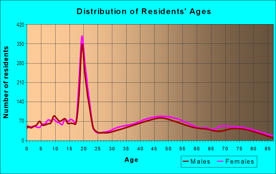
| Males: | 5,678 |
| Females: | 6,060 |
Males:
| This neighborhood: | 38.4 years |
| Whole city: | 46.1 years |
| This neighborhood: | 43.0 years |
| Whole city: | 51.2 years |
Average household size:
| Mercer: | 8.1 people |
| Beachwood: | 2.3 people |
Percentage of family households:
| Mercer: | 46.1% |
| Beachwood: | 40.2% |
| Here: | 54.8% |
| Beachwood: | 51.4% |
Percentage of married-couple families with children (among all households):
| Mercer: | 34.7% |
| Beachwood: | 35.7% |
Percentage of single-mother households (among all households):
| Mercer: | 7.0% |
| Beachwood: | 4.7% |
Percentage of never married males 15 years old and over:
Percentage of never married females 15 years old and over:
| Mercer: | 13.9% |
| Beachwood: | 10.9% |
Percentage of never married females 15 years old and over:
| Mercer: | 15.0% |
| city: | 14.7% |
Percentage of people that speak English not well or not at all:
| Mercer: | 1.2% |
| Beachwood: | 1.4% |
Percentage of people born in this state:
Percentage of people born in another U.S. state:
Percentage of native residents but born outside the U.S.:
Percentage of foreign born residents:
| Here: | 55.0% |
| Beachwood: | 58.0% |
Percentage of people born in another U.S. state:
| Mercer: | 35.2% |
| Beachwood: | 23.0% |
Percentage of native residents but born outside the U.S.:
| Here: | 0.9% |
| city: | 1.6% |
Percentage of foreign born residents:
| Here: | 9.0% |
| Beachwood: | 17.4% |

Owner-occupied
Renter-occupied


- Rooms in owner-occupied houses and condos in Mercer
- 01 room
- 762 rooms
- 1643 rooms
- 1404 rooms
- 2795 rooms
- 1626 rooms
- 4157 rooms
- 6008 rooms
- 1,8639+ rooms

- Rooms in renter-occupied apartments in Mercer
- 9531 room
- 3352 rooms
- 9073 rooms
- 9614 rooms
- 9785 rooms
- 4496 rooms
- 2957 rooms
- 1858 rooms
- 1349+ rooms
Owner-occupied
Renter-occupied

- Bedrooms in owner-occupied houses and condos in Mercer
- 0no bedroom
- 2111 bedroom
- 2542 bedrooms
- 6293 bedrooms
- 1,5464 bedrooms
- 8745+ bedrooms

- Bedrooms in renter-occupied apartments in Mercer
- 953no bedroom
- 9031 bedroom
- 1,6622 bedrooms
- 3993 bedrooms
- 3304 bedrooms
- 605+ bedrooms
Average number of cars or other vehicles available in houses/condos:
Average number of cars or other vehicles available in apartments:
| This neighborhood: | 2.0 |
| Beachwood: | 1.9 |
Average number of cars or other vehicles available in apartments:
| Here: | |
| city: |
Percentage of units with a mortgage:
| Mercer: | 66.5% |
| Beachwood: | 60.5% |
Average estimated value of detached houses in 2022 (64.3% of all units):
| Mercer: | $377,540 |
| Ohio: | $254,366 |

- Year house built in Mercer
- 2472020 or later
- 1822010 to 2019
- 3242000 to 2009
- 1911990 to 1999
- 2521980 to 1989
- 5391970 to 1979
- 5891960 to 1969
- 2,0051950 to 1959
- 6901940 to 1949
- 1,0221939 or earlier

City-data.com crime index for city in 2020 (higher means more crime):
| City: | 190.9 |
| U.S. average: | 219.5 |
Travel time to work (commute)
![Travel time to work (commute)]()
- 138Less than 5 minutes
- 5705 to 9 minutes
- 76810 to 14 minutes
- 50915 to 19 minutes
- 68620 to 24 minutes
- 45425 to 29 minutes
- 65230 to 34 minutes
- 22035 to 39 minutes
- 14840 to 44 minutes
- 35845 to 59 minutes
- 47360 to 89 minutes
- 5090 or more minutes

Means of transportation to work
![Means of transportation to work]()
- 71.6%4,060Drove a car alone
- 5.0%281Carpooled
- 14.1%800Bus
- 3.8%213Subway or elevated rail
- 2.1%120Long-distance train or commuter rail
- 3.4%192Light rail, streetcar or trolley
- 3.1%174Taxi
- 1.6%91Bicycle
- 3.9%221Walked
- 3.7%207Other means
- 16.8%950Worked at home

Time leaving home to go to work
![Time leaving home to go to work]()
- 23812:00 a.m. to 4:59 a.m.
- 885:00 a.m. to 5:29 a.m.
- 1035:30 a.m. to 5:59 a.m.
- 2636:00 a.m. to 6:29 a.m.
- 2236:30 a.m. to 6:59 a.m.
- 5817:00 a.m. to 7:29 a.m.
- 6747:30 a.m. to 7:59 a.m.
- 7858:00 a.m. to 8:29 a.m.
- 5178:30 a.m. to 8:59 a.m.
- 6039:00 a.m. to 9:59 a.m.
- 15410:00 a.m. to 10:59 a.m.
- 21811:00 a.m. to 11:59 a.m.
- 26012:00 p.m. to 3:59 p.m.
- 2124:00 p.m. to 11:59 p.m.

Occupations of males:
- Percentage of males in management occupations (except farmers):
Here: 23.6% city: 14.7%
- Percentage of males in business and financial operations occupations:
Here: 8.7% city: 8.3%
- Percentage of males in computer and mathematical occupations:
Here: 8.2% city: 7.3%
- Percentage of males in architecture and engineering occupations:
Here: 2.3% city: 2.2%
- Percentage of males in life, physical, and social science occupations:
Here: 1.4% city: 2.0%
- Percentage of males in community and social services occupations:
Here: 3.1% city: 2.4%
- Percentage of males in legal occupations:
Here: 4.5% city: 3.3%
- Percentage of males in education, training, and library occupations:
Here: 7.2% city: 5.7%
- Percentage of males in arts, design, entertainment, sports, and media occupations:
Here: 1.8% city: 1.4%
- Percentage of males in healthcare practitioners and technical occupations:
Here: 17.0% city: 12.2%
- Percentage of males in service occupations:
Here: 5.1% city: 12.0%
- Percentage of males in sales and office occupations:
Here: 6.5% city: 15.2%
- Percentage of males in construction, extraction, and maintenance occupations:
Here: 3.0% city: 1.2%
- Percentage of males in production occupations:
Here: 2.6% city: 2.4%
- Percentage of males in transportation occupations:
Here: 2.5% city: 1.3%
Occupations of females:
- Percentage of females in management occupations (except farmers):
Here: 11.5% city: 19.4%
- Percentage of females in business and financial operations occupations:
Here: 8.0% city: 5.6%
- Percentage of females in life, physical, and social science occupations:
Here: 2.6% city: 1.5%
- Percentage of females in community and social services occupations:
Here: 4.7% city: 3.8%
- Percentage of females in legal occupations:
Here: 1.7% city: 3.1%
- Percentage of females in education, training, and library occupations:
Here: 14.0% city: 13.6%
- Percentage of females in arts, design, entertainment, sports, and media occupations:
Here: 5.1% city: 3.7%
- Percentage of females in healthcare practitioners and technical occupations:
Here: 21.5% city: 18.6%
- Percentage of females in service occupations:
Here: 12.7% city: 7.6%
- Percentage of females in sales and office occupations:
Here: 13.2% city: 19.0%
- Percentage of females in transportation occupations:
Here: 1.1% city: 0.0%
- Percentage of females in material moving occupations:
Here: 2.0% city: 0.3%
Education in this neighborhood (subdivision or community):
- Percentage of people 3 years and older in K-12 schools:
Mercer: 21.8% Beachwood: 14.0%
- Percentage of people 3 years and older in undergraduate colleges:
Mercer: 13.7% Beachwood: 4.3%
- Percentage of people 3 years and older in grad. or professional schools:
Mercer: 3.1% Beachwood: 0.9%
- Percentage of students K-12 enrolled in private schools:
Mercer: 61.5% Beachwood: 32.6%
Percentage of population below poverty level:
| Mercer: | 5.6% |
| Beachwood: | 4.7% |
Median year owner moved in (as recorded in 2022):
| Mercer: | 2008 |
| Beachwood: | 2005 |
Percentage of married-couple families with both working:
| Mercer: | 89.9% |
| Beachwood: | 78.4% |

- 64.7%Utility gas
- 18.3%Electricity
- 6.5%No fuel used
- 5.8%Other fuel
- 2.0%Fuel oil, kerosene, etc.
- 1.8%Bottled, tank, or LP gas
- 0.9%Coal or coke
Highways in this neighborhood:
Shaker Blvd (State Rte 87)
Length: 4.45 miles
Directions: E-W, SE-NW
Address range: 20351 to 24799
Directions: E-W, SE-NW
Address range: 20351 to 24799
Chagrin Blvd (US Hwy 422)
Length: 0.44 miles
Direction: E-W
Address range: 20090 to 20899
Direction: E-W
Address range: 20090 to 20899
State Rte 8 (Northfield Rd)
Length: 0.24 miles
Direction: SE-NW
Address range: 3500 to 3633
Direction: SE-NW
Address range: 3500 to 3633
Roads and streets:
Fairmount Blvd
Length: 2.21 miles
Direction: E-W
Address range: 20452 to 24798
Direction: E-W
Address range: 20452 to 24798
Warrensville Center Rd
Length: 2.20 miles
Direction: N-S
Address range: 2649 to 3609
Direction: N-S
Address range: 2649 to 3609
Shelburne Rd
Length: 2.12 miles
Directions: E-W, SE-NW, SW-NE
Address range: 20100 to 24299
Directions: E-W, SE-NW, SW-NE
Address range: 20100 to 24299
S Woodland Rd
Length: 2.10 miles
Direction: E-W
Address range: 20100 to 24299
Direction: E-W
Address range: 20100 to 24299
Sulgrave Rd (W Sulgrave Oval)
Length: 1.06 miles
Directions: N-S, SE-NW, SW-NE
Address range: 2600 to 3213
Directions: N-S, SE-NW, SW-NE
Address range: 2600 to 3213
Green Rd
Length: 1.00 miles
Directions: N-S, SE-NW
Address range: 2663 to 3199
Directions: N-S, SE-NW
Address range: 2663 to 3199
Claythorne Rd
Length: 0.76 miles
Directions: E-W, N-S, SE-NW, SW-NE
Address range: 2680 to 21526
Directions: E-W, N-S, SE-NW, SW-NE
Address range: 2680 to 21526
Lyman Cir
Length: 0.71 miles
Directions: E-W, N-S, SE-NW, SW-NE
Address range: 1 to 99
Directions: E-W, N-S, SE-NW, SW-NE
Address range: 1 to 99
E Bryon Rd
Length: 0.66 miles
Directions: E-W, SW-NE
Address range: 21600 to 22999
Directions: E-W, SW-NE
Address range: 21600 to 22999
Somerset Dr
Length: 0.64 miles
Directions: E-W, N-S, SE-NW, SW-NE
Address range: 3100 to 3399
Directions: E-W, N-S, SE-NW, SW-NE
Address range: 3100 to 3399
Wimbledon Rd
Length: 0.63 miles
Directions: E-W, SW-NE
Address range: 23200 to 24199
Directions: E-W, SW-NE
Address range: 23200 to 24199
Laureldale Rd
Length: 0.59 miles
Direction: SW-NE
Address range: 23147 to 24299
Direction: SW-NE
Address range: 23147 to 24299
Lyman Blvd
Length: 0.59 miles
Direction: SE-NW
Address range: 23101 to 24281
Direction: SE-NW
Address range: 23101 to 24281
Belvoir Blvd
Length: 0.58 miles
Directions: N-S, SE-NW, SW-NE
Address range: 3100 to 3405
Directions: N-S, SE-NW, SW-NE
Address range: 3100 to 3405
Almar Dr
Length: 0.58 miles
Directions: E-W, SW-NE
Address range: 20400 to 21499
Directions: E-W, SW-NE
Address range: 20400 to 21499
W Bryon Rd
Length: 0.55 miles
Directions: E-W, SW-NE
Address range: 20401 to 21599
Directions: E-W, SW-NE
Address range: 20401 to 21599
S Belvoir Blvd
Length: 0.54 miles
Direction: N-S
Address range: 2661 to 2999
Direction: N-S
Address range: 2661 to 2999
University Blvd
Length: 0.53 miles
Directions: N-S, SE-NW
Address range: 2579 to 20899
Directions: N-S, SE-NW
Address range: 2579 to 20899
Calverton Rd
Length: 0.52 miles
Directions: E-W, SE-NW
Address range: 21921 to 22704
Directions: E-W, SE-NW
Address range: 21921 to 22704
Brantley Rd
Length: 0.51 miles
Directions: E-W, SW-NE
Address range: 20600 to 20740
Directions: E-W, SW-NE
Address range: 20600 to 20740
Rye Rd
Length: 0.51 miles
Directions: E-W, SW-NE
Address range: 21819 to 22799
Directions: E-W, SW-NE
Address range: 21819 to 22799
Duffield Rd
Length: 0.51 miles
Directions: E-W, SW-NE
Address range: 23300 to 24399
Directions: E-W, SW-NE
Address range: 23300 to 24399
Westchester Rd
Length: 0.50 miles
Directions: E-W, SE-NW
Address range: 21800 to 22729
Directions: E-W, SE-NW
Address range: 21800 to 22729
Hazelmere Rd
Length: 0.50 miles
Directions: E-W, SE-NW
Address range: 23300 to 24256
Directions: E-W, SE-NW
Address range: 23300 to 24256
Cranlyn Rd
Length: 0.49 miles
Directions: N-S, SE-NW, SW-NE
Address range: 2657 to 2799
Directions: N-S, SE-NW, SW-NE
Address range: 2657 to 2799
Douglas Rd
Length: 0.49 miles
Directions: E-W, N-S, SW-NE
Address range: 22000 to 22799
Directions: E-W, N-S, SW-NE
Address range: 22000 to 22799
Ashley Rd
Length: 0.47 miles
Directions: N-S, SE-NW, SW-NE
Address range: 2669 to 2780
Directions: N-S, SE-NW, SW-NE
Address range: 2669 to 2780
Landon Rd
Length: 0.47 miles
Directions: E-W, N-S, SE-NW
Address range: 2676 to 2799
Directions: E-W, N-S, SE-NW
Address range: 2676 to 2799
Parnell Rd
Length: 0.46 miles
Directions: E-W, N-S, SE-NW
Address range: 21700 to 22302
Directions: E-W, N-S, SE-NW
Address range: 21700 to 22302
Stanford Rd
Length: 0.46 miles
Direction: E-W
Address range: 23300 to 24299
Direction: E-W
Address range: 23300 to 24299
Inverness Rd
Length: 0.43 miles
Directions: E-W, N-S, SW-NE
Address range: 2600 to 2771
Directions: E-W, N-S, SW-NE
Address range: 2600 to 2771
Farnsleigh Rd
Length: 0.41 miles
Directions: E-W, SW-NE
Address range: 20144 to 21079
Directions: E-W, SW-NE
Address range: 20144 to 21079
Chesterton Rd
Length: 0.41 miles
Directions: E-W, N-S, SE-NW
Address range: 2675 to 2799
Directions: E-W, N-S, SE-NW
Address range: 2675 to 2799
Canterbury Ln
Length: 0.40 miles
Direction: E-W
Address range: 22200 to 22911
Direction: E-W
Address range: 22200 to 22911
Sydenham Rd
Length: 0.40 miles
Directions: E-W, SE-NW
Address range: 20600 to 21499
Directions: E-W, SE-NW
Address range: 20600 to 21499
Meldon Blvd
Length: 0.40 miles
Directions: E-W, N-S, SE-NW
Address range: 2700 to 24999
Directions: E-W, N-S, SE-NW
Address range: 2700 to 24999
Hermitage Rd
Length: 0.38 miles
Directions: E-W, SW-NE
Address range: 23500 to 24274
Directions: E-W, SW-NE
Address range: 23500 to 24274
Rocklyn Rd
Length: 0.38 miles
Directions: N-S, SW-NE
Address range: 2600 to 2746
Directions: N-S, SW-NE
Address range: 2600 to 2746
Milton Rd
Length: 0.37 miles
Directions: N-S, SW-NE
Address range: 2601 to 2699
Directions: N-S, SW-NE
Address range: 2601 to 2699
Morley Rd
Length: 0.37 miles
Directions: N-S, SE-NW
Address range: 2884 to 3202
Directions: N-S, SE-NW
Address range: 2884 to 3202
Colby Rd
Length: 0.37 miles
Directions: E-W, SE-NW, SW-NE
Address range: 20721 to 21309
Directions: E-W, SE-NW, SW-NE
Address range: 20721 to 21309
W Belvoir Oval
Length: 0.36 miles
Directions: E-W, N-S, SE-NW, SW-NE
Address range: 2800 to 3099
Directions: E-W, N-S, SE-NW, SW-NE
Address range: 2800 to 3099
E Belvoir Oval
Length: 0.36 miles
Directions: N-S, SE-NW, SW-NE
Address range: 2800 to 3099
Directions: N-S, SE-NW, SW-NE
Address range: 2800 to 3099
Rochester Rd
Length: 0.33 miles
Direction: N-S
Address range: 2665 to 2743
Direction: N-S
Address range: 2665 to 2743
Hadleigh Rd
Length: 0.31 miles
Directions: E-W, SE-NW
Address range: 4100 to 4199
Directions: E-W, SE-NW
Address range: 4100 to 4199
Mc Cauley Rd
Length: 0.30 miles
Directions: E-W, SW-NE
Address range: 21919 to 22698
Directions: E-W, SW-NE
Address range: 21919 to 22698
Sulgrave Oval (Sulgrave Rd)
Length: 0.29 miles
Directions: N-S, SE-NW, SW-NE
Address range: 2901 to 3099
Directions: N-S, SE-NW, SW-NE
Address range: 2901 to 3099
Traffic Cir
Length: 0.29 miles
Directions: E-W, N-S, SE-NW, SW-NE
Directions: E-W, N-S, SE-NW, SW-NE
Washington Blvd
Length: 0.28 miles
Directions: N-S, SE-NW
Address range: 14411 to 14511
Directions: N-S, SE-NW
Address range: 14411 to 14511
Hawthorne Dr
Length: 0.28 miles
Direction: E-W
Address range: 24400 to 24899
Direction: E-W
Address range: 24400 to 24899
Bryden Rd
Length: 0.25 miles
Direction: E-W
Address range: 23100 to 23699
Direction: E-W
Address range: 23100 to 23699
Lytle Rd
Length: 0.25 miles
Directions: E-W, N-S, SE-NW
Address range: 3528 to 3645
Directions: E-W, N-S, SE-NW
Address range: 3528 to 3645
Holmwood Rd
Length: 0.25 miles
Direction: SE-NW
Address range: 22600 to 22999
Direction: SE-NW
Address range: 22600 to 22999
Hardwick Rd
Length: 0.24 miles
Direction: SE-NW
Address range: 23100 to 23399
Direction: SE-NW
Address range: 23100 to 23399
N Park Blvd
Length: 0.23 miles
Direction: SW-NE
Address range: 20001 to 20499
Direction: SW-NE
Address range: 20001 to 20499
Fernwood Dr
Length: 0.23 miles
Directions: E-W, SE-NW
Address range: 23100 to 23399
Directions: E-W, SE-NW
Address range: 23100 to 23399
Helen Rd
Length: 0.22 miles
Directions: N-S, SW-NE
Address range: 3400 to 3499
Directions: N-S, SW-NE
Address range: 3400 to 3499
Halburton Rd
Length: 0.22 miles
Direction: E-W
Address range: 20893 to 21161
Direction: E-W
Address range: 20893 to 21161
Dryden Rd
Length: 0.21 miles
Directions: E-W, N-S, SE-NW
Address range: 2700 to 2742
Directions: E-W, N-S, SE-NW
Address range: 2700 to 2742
Halworth Rd
Length: 0.20 miles
Directions: E-W, N-S, SE-NW
Address range: 20600 to 20959
Directions: E-W, N-S, SE-NW
Address range: 20600 to 20959
Deborah Dr
Length: 0.20 miles
Direction: N-S
Address range: 2600 to 2699
Direction: N-S
Address range: 2600 to 2699
Fayette Rd
Length: 0.19 miles
Direction: SE-NW
Address range: 20500 to 20749
Direction: SE-NW
Address range: 20500 to 20749
Shaker Glen
Length: 0.19 miles
Directions: E-W, N-S, SE-NW
Address range: 1 to 99
Directions: E-W, N-S, SE-NW
Address range: 1 to 99
Wrenford Rd
Length: 0.19 miles
Directions: N-S, SE-NW
Address range: 2654 to 2686
Directions: N-S, SE-NW
Address range: 2654 to 2686
Buckhurst Dr
Length: 0.19 miles
Directions: E-W, N-S, SE-NW
Address range: 2600 to 24199
Directions: E-W, N-S, SE-NW
Address range: 2600 to 24199
Albert Ln
Length: 0.18 miles
Direction: E-W
Address range: 24300 to 24999
Direction: E-W
Address range: 24300 to 24999
Wadsworth Rd
Length: 0.18 miles
Directions: N-S, SW-NE
Address range: 2676 to 2725
Directions: N-S, SW-NE
Address range: 2676 to 2725
Carroll Blvd
Length: 0.17 miles
Direction: E-W
Address range: 4023 to 4138
Direction: E-W
Address range: 4023 to 4138
Shakercrest Blvd
Length: 0.16 miles
Direction: N-S
Address range: 2650 to 3099
Direction: N-S
Address range: 2650 to 3099
Colton Rd
Length: 0.16 miles
Direction: N-S
Address range: 3400 to 3499
Direction: N-S
Address range: 3400 to 3499
Woodside Ln
Length: 0.14 miles
Direction: E-W
Address range: 24100 to 24398
Direction: E-W
Address range: 24100 to 24398
Van Aken Blvd
Length: 0.14 miles
Directions: SE-NW, SW-NE
Address range: 20183 to 20351
Directions: SE-NW, SW-NE
Address range: 20183 to 20351
Falmouth Rd
Length: 0.13 miles
Directions: E-W, SW-NE
Address range: 2839 to 2898
Directions: E-W, SW-NE
Address range: 2839 to 2898
Shelley Rd
Length: 0.13 miles
Directions: N-S, SW-NE
Address range: 2718 to 2738
Directions: N-S, SW-NE
Address range: 2718 to 2738
S Green Rd
Length: 0.13 miles
Direction: N-S
Address range: 2602 to 2673
Direction: N-S
Address range: 2602 to 2673
Elmhurst Dr
Length: 0.12 miles
Directions: N-S, SW-NE
Address range: 2616 to 2699
Directions: N-S, SW-NE
Address range: 2616 to 2699
Farnsleigh Dr (Farnsleigh Rd)
Length: 0.12 miles
Direction: SW-NE
Address range: 21000 to 21131
Direction: SW-NE
Address range: 21000 to 21131
Glenmore Rd
Length: 0.11 miles
Directions: N-S, SE-NW, SW-NE
Address range: 2893 to 2999
Directions: N-S, SE-NW, SW-NE
Address range: 2893 to 2999
Tunbridge Ln
Length: 0.10 miles
Direction: E-W
Address range: 24250 to 24302
Direction: E-W
Address range: 24250 to 24302
Brentwood Dr (Brentwood Rd)
Length: 0.10 miles
Direction: N-S
Address range: 2642 to 2699
Direction: N-S
Address range: 2642 to 2699
Boyce Rd
Length: 0.09 miles
Directions: N-S, SE-NW, SW-NE
Address range: 2900 to 2969
Directions: N-S, SE-NW, SW-NE
Address range: 2900 to 2969
Whiton Rd
Length: 0.08 miles
Directions: N-S, SW-NE
Address range: 2600 to 2659
Directions: N-S, SW-NE
Address range: 2600 to 2659
Lomond Blvd
Length: 0.08 miles
Direction: N-S
Address range: 20200 to 20299
Direction: N-S
Address range: 20200 to 20299
Beechmont Ct
Length: 0.08 miles
Direction: E-W
Address range: 24500 to 24799
Direction: E-W
Address range: 24500 to 24799
Dianne Dr
Length: 0.08 miles
Direction: E-W
Address range: 24500 to 24799
Direction: E-W
Address range: 24500 to 24799
Marchmont Rd
Length: 0.07 miles
Direction: E-W
Address range: 20028 to 20209
Direction: E-W
Address range: 20028 to 20209
Laurelhurst Rd
Length: 0.06 miles
Direction: SW-NE
Address range: 2564 to 2605
Direction: SW-NE
Address range: 2564 to 2605
S Park Blvd
Length: 0.04 miles
Direction: E-W
Address range: 20232 to 20301
Direction: E-W
Address range: 20232 to 20301
Other features:
Doan Brk
Length: 0.25 miles
Directions: E-W, SW-NE
Directions: E-W, SW-NE