Bridge Statistics for Amherst, Virginia (VA)
Condition, Traffic, Stress, Structural Evaluation, Project Costs
- National Bridge Inventory (NBI) Statistics
- 30Number of bridges
- 292ft / 88.6mTotal length
- $5,272,000Total costs
- 254,768Total average daily traffic
- 23,678Total average daily truck traffic
- National Bridge Inventory (NBI) Registered Bridges for Amherst
- No street view available for this location
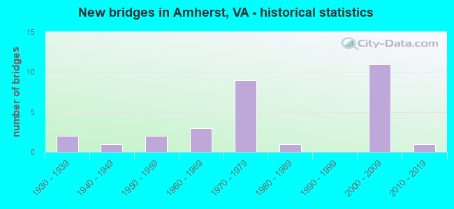
- New bridges - historical statistics
- 21930-1939
- 11940-1949
- 21950-1959
- 31960-1969
- 91970-1979
- 11980-1989
- 112000-2009
- 12010-2019


- Bridge Condition - Deck
- 20.0%Very good
- 53.3%Good
- 20.0%Satisfactory
- 6.7%Fair

- Bridge Condition - Superstructure
- 46.7%Very good
- 20.0%Good
- 26.7%Satisfactory
- 6.7%Fair

- Bridge Condition - Substructure
- 6.7%Very good
- 46.7%Good
- 40.0%Satisfactory
- 6.7%Fair

- Bridge Condition - Channel
- 14.3%Very good
- 14.3%Good
- 42.9%Satisfactory
- 28.6%Fair

- Bridge Condition - Culverts
- 42.9%Good
- 42.9%Satisfactory
- 14.3%Fair
Find on map >> Show street view
Structure Number: 1315, Location: .71-Rt 151 / 1.10 Rt 610 (Lat: 37.626969, Lng: -79.004169), Route carried "on" structure: US 29, Year Built: 1947, Status: Open, Structure Length: 1.46m (4.79ft), Average Daily Traffic: 11,985 (year 2020), Truck Traffic: 9%, Average Future Daily Traffic: 16,779 (year 2040), Design Load: HS 20, Features Intersected: Myra Creek
Minimum Vertical Clearance: 30+ m (98+ ft), Kilometerpoint: 148.704, Lanes on structure: 2, Base Highway Network: Yes, Owner: State Highway Agency, Approaching Roadway Width: 11.0m (36.1ft), Skew: 4 degrees, Material/Design: Concrete, Design/Construction: Tee Beam, Number Of Spans In Main Unit: 1, Length of Maximum Span: 13.5m (44.3ft), Curb or Sidewalk Widths: Left: 0.5m (1.6ft), Right: 0.5m (1.6ft), Curb-To-Curb Width: 10.4m (34.1ft), Out-to-Out Width: 12.2m (40.0ft)
Condition: Deck: Satisfactory, Superstructure: Satisfactory, Substructure: Satisfactory, Channel: Satisfactory, Operating Rating: 45.4 metric tons, Method Used To Determine Operating Rating: Load Factor (LF), Inventory Rating: 27.2 metric tons, Method Used To Determine Inventory Rating: Load Factor (LF), Structural Evaluation: Equal to present minimum criteria, Deck Geometry: Meets minimum limits, Waterway Adequacy: Better than present minimum criteria, Approach Roadway Alignment: Better than present minimum criteria, Designated Inspection Frequency: Every 24 months, Inspection Date: June 2021, Deck Structure Type: Concrete Cast-file-Place, Wearing Surface/Protective System: Wearing Surface: Bituminous
Find on map >> Show street view
Structure Number: 1331, Location: .09-29 Bus/1.76-Rt 60 (Lat: 37.561069, Lng: -79.063758), Route carried "on" structure: Bypass US 29, Year Built: 1969, Status: Open, Structure Length: 0.73m (2.40ft), Average Daily Traffic: 10,163 (year 2020), Truck Traffic: 10%, Average Future Daily Traffic: 14,230 (year 2040), Design Load: HS 20, Features Intersected: Rutledge Creek, Facility Carried by Structure: Monacan Parkway
Minimum Vertical Clearance: 30+ m (98+ ft), Kilometerpoint: 139.426, Lanes on structure: 2, Base Highway Network: Yes, Owner: State Highway Agency, Approaching Roadway Width: 8.5m (27.9ft), Skew: 4 degrees, Material/Design: Concrete, Design/Construction: Culvert, Number Of Spans In Main Unit: 2, Length of Maximum Span: 3.4m (11.2ft)
Condition: Channel: Fair, Culverts: Satisfactory, Operating Rating: 89.8 metric tons, Method Used To Determine Operating Rating: Load Factor (LF), Inventory Rating: 57.2 metric tons, Method Used To Determine Inventory Rating: Load Factor (LF), Structural Evaluation: Equal to present minimum criteria, Waterway Adequacy: Equal to present desirable criteria, Approach Roadway Alignment: Equal to present desirable criteria, Designated Inspection Frequency: Every 24 months, Inspection Date: November 2021
Find on map >> Show street view
Structure Number: 1332, Location: 1.18-S Bus 29 / .67-Rt 60 (Lat: 37.573253, Lng: -79.052147), Route carried "on" structure: Bypass US 29, Year Built: 1970, Status: Open, Structure Length: 0.76m (2.49ft), Average Daily Traffic: 20,327 (year 2020), Truck Traffic: 10%, Average Future Daily Traffic: 28,458 (year 2040), Features Intersected: Rutledge Creek, Facility Carried by Structure: NBL&SBL Amhst Hwy
Minimum Vertical Clearance: 30+ m (98+ ft), Kilometerpoint: 141.182, Lanes on structure: 4, Base Highway Network: Yes, Owner: State Highway Agency, Approaching Roadway Width: 8.2m (26.9ft), Material/Design: Concrete, Design/Construction: Culvert, Number Of Spans In Main Unit: 3, Length of Maximum Span: 2.4m (7.9ft)
Condition: Channel: Fair, Culverts: Satisfactory, Operating Rating: 89.8 metric tons, Method Used To Determine Operating Rating: Load Factor (LF), Inventory Rating: 89.8 metric tons, Method Used To Determine Inventory Rating: Load Factor (LF), Structural Evaluation: Equal to present minimum criteria, Waterway Adequacy: Better than present minimum criteria, Approach Roadway Alignment: Equal to present desirable criteria, Length Of Structure Improvement: 14.36m (47.11ft), Designated Inspection Frequency: Every 24 months, Inspection Date: November 2021, Bridge Improvement Cost: $942,000, Roadway Improvement Cost: $94,000, Total Project Cost: $1,413,000 ( Estimate for 2015)
Find on map >> Show street view
Structure Number: 1333, Location: .84-S Bus 29 / 1.01-Rt 60 (Lat: 37.571528, Lng: -79.052694), Route carried "on" structure: Bypass US 29, Year Built: 1969, Status: Open, Structure Length: 0.85m (2.79ft), Average Daily Traffic: 10,163 (year 2020), Truck Traffic: 10%, Average Future Daily Traffic: 14,230 (year 2040), Features Intersected: Rutledge Creek, Facility Carried by Structure: NBL Amherst Hwy
Minimum Vertical Clearance: 30+ m (98+ ft), Kilometerpoint: 140.638, Lanes on structure: 2, Base Highway Network: Yes, Owner: State Highway Agency, Approaching Roadway Width: 7.3m (24.0ft), Skew: 4 degrees, Material/Design: Concrete, Design/Construction: Culvert, Number Of Spans In Main Unit: 3, Length of Maximum Span: 2.6m (8.5ft)
Condition: Channel: Satisfactory, Culverts: Satisfactory, Operating Rating: 89.8 metric tons, Method Used To Determine Operating Rating: Load Factor (LF), Inventory Rating: 89.8 metric tons, Method Used To Determine Inventory Rating: Load Factor (LF), Structural Evaluation: Equal to present minimum criteria, Waterway Adequacy: Better than present minimum criteria, Approach Roadway Alignment: Equal to present desirable criteria, Designated Inspection Frequency: Every 24 months, Inspection Date: November 2021
Find on map >> Show street view
Structure Number: 1372, Location: 0.52-Amhers CL/0.11-Rt 29 (Lat: 37.581850, Lng: -79.046086), Route carried "on" structure: US 60, Year Built: 1971, Status: Open, Structure Length: 8.11m (26.61ft), Average Daily Traffic: 5,256 (year 2020), Truck Traffic: 10%, Average Future Daily Traffic: 7,358 (year 2040), Design Load: HS 20+Mod, Features Intersected: Rt 29 NBL & SBL
Minimum Vertical Clearance: 30+ m (98+ ft), Kilometerpoint: 147.175, Lanes on structure: 4, Lanes under structure: 5, Owner: State Highway Agency, Approaching Roadway Width: 21.9m (71.9ft), Skew: 23 degrees, Material/Design: Steel, Design/Construction: Stringer/Multi-beam, Number Of Spans In Main Unit: 4, Length of Maximum Span: 28.0m (91.9ft), Curb-To-Curb Width: 21.9m (71.9ft), Out-to-Out Width: 23.2m (76.1ft)
Condition: Deck: Good, Superstructure: Good, Substructure: Good, Operating Rating: 63.5 metric tons, Method Used To Determine Operating Rating: Load and Resistance Factor (LRFR), Inventory Rating: 49.0 metric tons, Method Used To Determine Inventory Rating: Load and Resistance Factor (LRFR), Structural Evaluation: Better than present minimum criteria, Deck Geometry: Superior to present desirable criteria, Underclear: Somewhat better than minimum adequacy, Approach Roadway Alignment: Equal to present desirable criteria, Designated Inspection Frequency: Every 24 months, Inspection Date: March 2021, Deck Structure Type: Concrete Cast-file-Place, Wearing Surface/Protective System: Wearing Surface: Latex Concrete
Find on map >> Show street view
Structure Number: 1411, Location: 0.70-Rt.765/1.00-Rt.739 (Lat: 37.613397, Lng: -78.994608), Route carried "on" structure: County highway 608, Year Built: 1976, Status: Open, Structure Length: 0.70m (2.30ft), Average Daily Traffic: 186 (year 2016), Average Future Daily Traffic: 208 (year 2040), Features Intersected: Turner Creek, Facility Carried by Structure: Toytown Road
Minimum Vertical Clearance: 30+ m (98+ ft), Kilometerpoint: 7.948, Lanes on structure: 2, Owner: State Highway Agency, Approaching Roadway Width: 5.5m (18.0ft), Skew: 1 degrees, Material/Design: Steel, Design/Construction: Culvert, Number Of Spans In Main Unit: 2, Length of Maximum Span: 3.0m (9.8ft)
Condition: Channel: Fair, Culverts: Fair, Operating Rating: 52.6 metric tons, Method Used To Determine Operating Rating: Field evaluation and documented engineering judgment, Inventory Rating: 31.8 metric tons, Method Used To Determine Inventory Rating: Field evaluation and documented engineering judgment, Structural Evaluation: Somewhat better than minimum adequacy, Waterway Adequacy: Better than present minimum criteria, Approach Roadway Alignment: Equal to present desirable criteria, Designated Inspection Frequency: Every 24 months, Inspection Date: October 2020
Find on map >> Show street view
Structure Number: 1412, Location: .24 Rt 729 / .00 Rt 708 (Lat: 37.626208, Lng: -78.977125), Route carried "on" structure: County highway 610, Year Built: 1980, Status: Open, Structure Length: 4.33m (14.21ft), Average Daily Traffic: 756 (year 2020), Truck Traffic: 1%, Average Future Daily Traffic: 832 (year 2040), Design Load: HS 20+Mod, Features Intersected: NS Railway, Facility Carried by Structure: New Glasgow Road
Minimum Vertical Clearance: 30+ m (98+ ft), Kilometerpoint: 47.778, Lanes on structure: 2, Owner: State Highway Agency, Approaching Roadway Width: 6.1m (20.0ft), Material/Design: Steel, Design/Construction: Stringer/Multi-beam, Number Of Spans In Main Unit: 3, Length of Maximum Span: 15.3m (50.2ft), Curb or Sidewalk Widths: Left: 0.3m (1.0ft), Right: 0.3m (1.0ft), Curb-To-Curb Width: 8.1m (26.6ft), Out-to-Out Width: 9.1m (29.9ft)
Condition: Deck: Good, Superstructure: Good, Substructure: Satisfactory, Operating Rating: 89.8 metric tons, Method Used To Determine Operating Rating: Load and Resistance Factor (LRFR), Inventory Rating: 81.6 metric tons, Method Used To Determine Inventory Rating: Load and Resistance Factor (LRFR), Structural Evaluation: Equal to present minimum criteria, Deck Geometry: Somewhat better than minimum adequacy, Underclear: Superior to present desirable criteria, Approach Roadway Alignment: Equal to present minimum criteria, Designated Inspection Frequency: Every 24 months, Inspection Date: July 2021, Deck Structure Type: Concrete Cast-file-Place, Wearing Surface/Protective System: Deck Protection: Epoxy Coated Reinforcing
Find on map >> Show street view
Structure Number: 1505, Location: 0.10-Rt.1125/0.80-Rt.606 (Lat: 37.576728, Lng: -79.048319), Route carried "on" structure: County highway 659, Year Built: 1950, Year Reconstructed: 2014, Status: Open, Structure Length: 1.28m (4.20ft), Average Daily Traffic: 323 (year 2020), Truck Traffic: 2%, Average Future Daily Traffic: 355 (year 2040), Design Load: HL 93, Features Intersected: Rutledge Creek, Facility Carried by Structure: Union Hill Road
Minimum Vertical Clearance: 30+ m (98+ ft), Kilometerpoint: 0.981, Lanes on structure: 2, Owner: State Highway Agency, Approaching Roadway Width: 5.5m (18.0ft), Material/Design: Prestressed concrete, Design/Construction: Slab, Number Of Spans In Main Unit: 1, Length of Maximum Span: 11.8m (38.7ft), Curb-To-Curb Width: 6.7m (22.0ft), Out-to-Out Width: 7.3m (24.0ft)
Condition: Deck: Very good, Superstructure: Very good, Substructure: Fair, Channel: Very good, Operating Rating: 56.2 metric tons, Method Used To Determine Operating Rating: Load and Resistance Factor (LRFR), Inventory Rating: 40.8 metric tons, Method Used To Determine Inventory Rating: Load and Resistance Factor (LRFR), Structural Evaluation: Somewhat better than minimum adequacy, Deck Geometry: Meets minimum limits, Waterway Adequacy: Somewhat better than minimum adequacy, Approach Roadway Alignment: Equal to present minimum criteria, Length Of Structure Improvement: 1.77m (5.81ft), Designated Inspection Frequency: Every 24 months, Inspection Date: December 2021, Bridge Improvement Cost: $309,000, Roadway Improvement Cost: $31,000, Total Project Cost: $463,000 ( Estimate for 2014), Deck Structure Type: Other, Wearing Surface/Protective System: Wearing Surface: Bituminous
Find on map >> Show street view
Structure Number: 1506, Location: 0.83-Rt 821/1.97-Dead End (Lat: 37.545506, Lng: -78.997294), Route carried "on" structure: County highway 659, Year Built: 1932, Status: Open, Structure Length: 0.95m (3.12ft), Average Daily Traffic: 51 (year 2019), Average Future Daily Traffic: 58 (year 2040), Features Intersected: Rocky Creek, Facility Carried by Structure: Buffalo Ridge Road
Minimum Vertical Clearance: 30+ m (98+ ft), Kilometerpoint: 8.222, Lanes on structure: 1, Owner: State Highway Agency, Approaching Roadway Width: 3.7m (12.1ft), Skew: 1 degrees, Material/Design: Steel, Design/Construction: Stringer/Multi-beam, Number Of Spans In Main Unit: 2, Length of Maximum Span: 3.8m (12.5ft), Curb or Sidewalk Widths: Left: 0.2m (0.7ft), Right: 0.2m (0.7ft), Curb-To-Curb Width: 3.7m (12.1ft), Out-to-Out Width: 4.3m (14.1ft)
Condition: Deck: Very good, Superstructure: Satisfactory, Substructure: Satisfactory, Channel: Fair, Operating Rating: 59.0 metric tons, Method Used To Determine Operating Rating: Load Factor (LF), Inventory Rating: 35.4 metric tons, Method Used To Determine Inventory Rating: Load Factor (LF), Structural Evaluation: Equal to present minimum criteria, Deck Geometry: Meets minimum limits, Waterway Adequacy: Equal to present minimum criteria, Approach Roadway Alignment: Equal to present desirable criteria, Length Of Structure Improvement: 1.52m (4.99ft), Designated Inspection Frequency: Every 24 months, Inspection Date: March 2021, Bridge Improvement Cost: $266,000, Roadway Improvement Cost: $27,000, Total Project Cost: $401,000, Deck Structure Type: Wood or Timber, Wearing Surface/Protective System: Wearing Surface: Bituminous
Find on map >> Show street view
Structure Number: 1512, Location: .05-Rt 661/.68-Rt 604 (Lat: 37.528033, Lng: -79.090564), Route carried "on" structure: County highway 663, Year Built: 1955, Status: Open, Structure Length: 3.91m (12.83ft), Average Daily Traffic: 1,518 (year 2020), Truck Traffic: 4%, Average Future Daily Traffic: 1,670 (year 2040), Design Load: H 15, Features Intersected: NS Railroad, Facility Carried by Structure: N Coolwell Road
Minimum Vertical Clearance: 30+ m (98+ ft), Kilometerpoint: 9.397, Lanes on structure: 2, Owner: State Highway Agency, Approaching Roadway Width: 6.7m (22.0ft), Material/Design: Concrete, Design/Construction: Tee Beam, Number Of Spans In Main Unit: 3, Length of Maximum Span: 12.8m (42.0ft), Curb or Sidewalk Widths: Left: 0.6m (2.0ft), Right: 0.6m (2.0ft), Curb-To-Curb Width: 6.7m (22.0ft), Out-to-Out Width: 8.0m (26.2ft)
Condition: Deck: Satisfactory, Superstructure: Fair, Substructure: Satisfactory, Operating Rating: 45.4 metric tons, Method Used To Determine Operating Rating: Load Factor (LF), Inventory Rating: 26.3 metric tons, Method Used To Determine Inventory Rating: Load Factor (LF), Structural Evaluation: Somewhat better than minimum adequacy, Deck Geometry: High priority of corrective action, Underclear: Somewhat better than minimum adequacy, Approach Roadway Alignment: Equal to present minimum criteria, Length Of Structure Improvement: 5.06m (16.60ft), Designated Inspection Frequency: Every 24 months, Inspection Date: March 2020, Bridge Improvement Cost: $511,000, Roadway Improvement Cost: $51,000, Total Project Cost: $767,000 ( Estimate for 2014), Deck Structure Type: Concrete Cast-file-Place, Wearing Surface/Protective System: Wearing Surface: Bituminous
Find on map >> Show street view
Structure Number: 1531, Location: 0.86-Rt 617/0.94-Rt 690 (Lat: 37.611167, Lng: -79.071017), Route carried "on" structure: County highway 689, Year Built: 1932, Year Reconstructed: 2012, Status: Open, Structure Length: 1.31m (4.30ft), Average Daily Traffic: 56 (year 2016), Average Future Daily Traffic: 63 (year 2040), Features Intersected: Huff Creek, Facility Carried by Structure: East Monitor Road
Minimum Vertical Clearance: 30+ m (98+ ft), Kilometerpoint: 2.478, Lanes on structure: 2, Owner: State Highway Agency, Approaching Roadway Width: 6.2m (20.3ft), Material/Design: Steel, Design/Construction: Stringer/Multi-beam, Number Of Spans In Main Unit: 1, Length of Maximum Span: 11.1m (36.4ft), Curb-To-Curb Width: 6.2m (20.3ft), Out-to-Out Width: 6.6m (21.7ft)
Condition: Deck: Very good, Superstructure: Very good, Substructure: Good, Channel: Satisfactory, Operating Rating: 59.9 metric tons, Method Used To Determine Operating Rating: Load and Resistance Factor (LRFR), Inventory Rating: 46.3 metric tons, Method Used To Determine Inventory Rating: Load and Resistance Factor (LRFR), Structural Evaluation: Better than present minimum criteria, Deck Geometry: Somewhat better than minimum adequacy, Waterway Adequacy: Equal to present minimum criteria, Approach Roadway Alignment: Equal to present minimum criteria, Designated Inspection Frequency: Every 24 months, Inspection Date: January 2022, Deck Structure Type: Wood or Timber, Wearing Surface/Protective System: Wearing Surface: Bituminous, Membrane: Preformed Fabric
Find on map >> Show street view
Structure Number: 1536, Location: .70 Rt 658 / 1.06 Rt 822 (Lat: 37.599003, Lng: -78.995728), Route carried "on" structure: County highway 739, Year Built: 1970, Status: Open, Structure Length: 1.55m (5.09ft), Average Daily Traffic: 742 (year 2020), Truck Traffic: 4%, Average Future Daily Traffic: 984 (year 2040), Features Intersected: Turner Creek, Facility Carried by Structure: Boxwood Farm Road
Minimum Vertical Clearance: 30+ m (98+ ft), Kilometerpoint: 3.669, Lanes on structure: 2, Owner: State Highway Agency, Approaching Roadway Width: 6.4m (21.0ft), Material/Design: Steel, Design/Construction: Stringer/Multi-beam, Number Of Spans In Main Unit: 1, Length of Maximum Span: 13.9m (45.6ft), Curb or Sidewalk Widths: Left: 0.5m (1.6ft), Right: 0.5m (1.6ft), Curb-To-Curb Width: 8.5m (27.9ft), Out-to-Out Width: 9.4m (30.8ft)
Condition: Deck: Good, Superstructure: Very good, Substructure: Good, Channel: Satisfactory, Operating Rating: 56.2 metric tons, Method Used To Determine Operating Rating: Load and Resistance Factor (LRFR), Inventory Rating: 43.5 metric tons, Method Used To Determine Inventory Rating: Load and Resistance Factor (LRFR), Structural Evaluation: Better than present minimum criteria, Deck Geometry: Somewhat better than minimum adequacy, Waterway Adequacy: Better than present minimum criteria, Approach Roadway Alignment: Somewhat better than minimum adequacy, Designated Inspection Frequency: Every 24 months, Inspection Date: August 2021, Deck Structure Type: Concrete Cast-file-Place, Wearing Surface/Protective System: Wearing Surface: Bituminous
Find on map >> Show street view
Structure Number: 1537, Location: 0.00-Rt29Bus/0.15-Rt731 (Lat: 37.597461, Lng: -79.032086), Route carried "on" structure: County highway 739, Year Built: 1971, Status: Open, Structure Length: 5.58m (18.31ft), Average Daily Traffic: 2,770 (year 2020), Truck Traffic: 3%, Average Future Daily Traffic: 3,047 (year 2040), Design Load: HS 20+Mod, Features Intersected: Route 29 NBL & SBL, Facility Carried by Structure: Boxwood Farm Road
Minimum Vertical Clearance: 5.30m (17.39ft), Kilometerpoint: 0.016, Lanes on structure: 2, Lanes under structure: 4, Owner: State Highway Agency, Approaching Roadway Width: 10.4m (34.1ft), Material/Design: Steel continuous, Design/Construction: Stringer/Multi-beam, Number Of Spans In Main Unit: 2, Length of Maximum Span: 28.0m (91.9ft), Curb-To-Curb Width: 9.8m (32.2ft), Out-to-Out Width: 11.0m (36.1ft)
Condition: Deck: Satisfactory, Superstructure: Satisfactory, Substructure: Satisfactory, Operating Rating: 67.1 metric tons, Method Used To Determine Operating Rating: Load and Resistance Factor (LRFR), Inventory Rating: 51.7 metric tons, Method Used To Determine Inventory Rating: Load and Resistance Factor (LRFR), Structural Evaluation: Equal to present minimum criteria, Deck Geometry: Meets minimum limits, Underclear: Equal to present minimum criteria, Approach Roadway Alignment: Equal to present desirable criteria, Designated Inspection Frequency: Every 24 months, Inspection Date: November 2021, Deck Structure Type: Concrete Cast-file-Place, Wearing Surface/Protective System: Wearing Surface: Epoxy Overlay
Find on map >> Show street view
Structure Number: 1539, Location: .64 Rt 822 / 1.18 Rt 658 (Lat: 37.596831, Lng: -79.004797), Route carried "on" structure: County highway 739, Year Built: 1960, Status: Open, Structure Length: 5.33m (17.49ft), Average Daily Traffic: 742 (year 2020), Truck Traffic: 5%, Average Future Daily Traffic: 984 (year 2040), Features Intersected: Buffalo River, Facility Carried by Structure: Boxwood Farm Road
Minimum Vertical Clearance: 30+ m (98+ ft), Kilometerpoint: 2.993, Lanes on structure: 2, Owner: State Highway Agency, Approaching Roadway Width: 7.0m (23.0ft), Skew: 3 degrees, Material/Design: Steel, Design/Construction: Stringer/Multi-beam, Number Of Spans In Main Unit: 3, Length of Maximum Span: 16.6m (54.5ft), Curb or Sidewalk Widths: Left: 0.5m (1.6ft), Right: 0.5m (1.6ft), Curb-To-Curb Width: 7.3m (24.0ft), Out-to-Out Width: 8.8m (28.9ft)
Condition: Deck: Fair, Superstructure: Satisfactory, Substructure: Satisfactory, Channel: Satisfactory, Operating Rating: 48.1 metric tons, Method Used To Determine Operating Rating: Load and Resistance Factor (LRFR), Inventory Rating: 37.2 metric tons, Method Used To Determine Inventory Rating: Load and Resistance Factor (LRFR), Structural Evaluation: Equal to present minimum criteria, Deck Geometry: Meets minimum limits, Waterway Adequacy: Better than present minimum criteria, Approach Roadway Alignment: Equal to present minimum criteria, Length Of Structure Improvement: 6.22m (20.41ft), Designated Inspection Frequency: Every 24 months, Inspection Date: June 2021, Bridge Improvement Cost: $1,085,000, Roadway Improvement Cost: $109,000, Total Project Cost: $1,628,000 ( Estimate for 2015), Deck Structure Type: Concrete Cast-file-Place, Wearing Surface/Protective System: Wearing Surface: Bituminous
Find on map >> Show street view
Structure Number: 25956, Location: 5.72-Rt130/1.37-Rt29 (Lat: 37.542431, Lng: -79.067558), Route carried "on" structure: US 29, Year Built: 2005, Status: Open, Structure Length: 1.87m (6.14ft), Average Daily Traffic: 14,503 (year 2020), Truck Traffic: 10%, Average Future Daily Traffic: 20,303 (year 2040), Features Intersected: Higginbotham Creek
Minimum Vertical Clearance: 30+ m (98+ ft), Kilometerpoint: 0.000, Lanes on structure: 4, Base Highway Network: Yes, Owner: State Highway Agency, Approaching Roadway Width: 7.9m (25.9ft), Skew: 3 degrees, Material/Design: Concrete, Design/Construction: Culvert, Number Of Spans In Main Unit: 4, Length of Maximum Span: 4.5m (14.8ft)
Condition: Channel: Satisfactory, Culverts: Good, Operating Rating: 89.8 metric tons, Method Used To Determine Operating Rating: Load Factor (LF), Inventory Rating: 89.8 metric tons, Method Used To Determine Inventory Rating: Load Factor (LF), Structural Evaluation: Better than present minimum criteria, Waterway Adequacy: Equal to present desirable criteria, Approach Roadway Alignment: Equal to present desirable criteria, Length Of Structure Improvement: 1.52m (4.99ft), Designated Inspection Frequency: Every 24 months, Inspection Date: August 2021, Bridge Improvement Cost: $400,000, Roadway Improvement Cost: $40,000, Total Project Cost: $600,000 ( Estimate for 2015)
Find on map >> Show street view
Structure Number: 25959, Location: 1.00-Rt.663/0.30-Rt.670 (Lat: 37.522667, Lng: -79.064447), Route carried "on" structure: County highway 604, Year Built: 2004, Status: Open, Structure Length: 8.60m (28.22ft), Average Daily Traffic: 587 (year 2020), Truck Traffic: 5%, Average Future Daily Traffic: 646 (year 2040), Design Load: HS 20+Mod, Features Intersected: Route 29 Bypass, Facility Carried by Structure: Bobwhite Road
Minimum Vertical Clearance: 7.82m (25.66ft), Kilometerpoint: 0.000, Lanes on structure: 2, Lanes under structure: 4, Owner: State Highway Agency, Approaching Roadway Width: 7.3m (24.0ft), Skew: 1 degrees, Material/Design: Steel continuous, Design/Construction: Stringer/Multi-beam, Number Of Spans In Main Unit: 2, Length of Maximum Span: 43.0m (141.1ft), Curb-To-Curb Width: 11.3m (37.1ft), Out-to-Out Width: 12.3m (40.4ft)
Condition: Deck: Good, Superstructure: Very good, Substructure: Good, Operating Rating: 99.8 metric tons, Method Used To Determine Operating Rating: Load and Resistance Factor (LRFR), Inventory Rating: 99.8 metric tons, Method Used To Determine Inventory Rating: Load and Resistance Factor (LRFR), Structural Evaluation: Better than present minimum criteria, Deck Geometry: Better than present minimum criteria, Underclear: Equal to present minimum criteria, Approach Roadway Alignment: Equal to present desirable criteria, Designated Inspection Frequency: Every 24 months, Inspection Date: September 2020, Deck Structure Type: Concrete Cast-file-Place, Wearing Surface/Protective System: Wearing Surface: Epoxy Overlay, Deck Protection: Epoxy Coated Reinforcing
Find on map >> Show street view
Structure Number: 26397, Location: 0.68-SCL Amhe/0.15-Rt.661 (Lat: 37.550889, Lng: -79.067592), Route carried "on" structure: County highway 624, Year Built: 2004, Status: Open, Structure Length: 10.21m (33.50ft), Average Daily Traffic: 495 (year 2020), Truck Traffic: 2%, Average Future Daily Traffic: 544 (year 2040), Design Load: HS 20+Mod, Features Intersected: Route 29 Bypass, Facility Carried by Structure: Sweet Briar Dr.
Minimum Vertical Clearance: 8.69m (28.51ft), Kilometerpoint: 1.030, Lanes on structure: 2, Lanes under structure: 4, Owner: State Highway Agency, Approaching Roadway Width: 7.9m (25.9ft), Material/Design: Steel continuous, Design/Construction: Stringer/Multi-beam, Number Of Spans In Main Unit: 2, Length of Maximum Span: 59.4m (194.9ft), Curb-To-Curb Width: 8.6m (28.2ft), Out-to-Out Width: 9.6m (31.5ft)
Condition: Deck: Good, Superstructure: Very good, Substructure: Good, Operating Rating: 46.3 metric tons, Method Used To Determine Operating Rating: Load and Resistance Factor (LRFR), Inventory Rating: 35.4 metric tons, Method Used To Determine Inventory Rating: Load and Resistance Factor (LRFR), Structural Evaluation: Better than present minimum criteria, Deck Geometry: Somewhat better than minimum adequacy, Underclear: Better than present minimum criteria, Approach Roadway Alignment: Equal to present desirable criteria, Designated Inspection Frequency: Every 24 months, Inspection Date: Febuary 2021, Deck Structure Type: Concrete Cast-file-Place, Wearing Surface/Protective System: Wearing Surface: Epoxy Overlay, Deck Protection: Epoxy Coated Reinforcing
Find on map >> Show street view
Structure Number: 26399, Location: 0.23 SCL Amh/0.05 29 BP (Lat: 37.555200, Lng: -79.065900), Route carried "on" structure: US 29, Year Built: 2004, Status: Open, Structure Length: 10.55m (34.61ft), Average Daily Traffic: 4,372 (year 2020), Truck Traffic: 4%, Average Future Daily Traffic: 4,810 (year 2040), Design Load: HS 20+Mod, Features Intersected: Route 29 Bypass
Minimum Vertical Clearance: 30+ m (98+ ft), Kilometerpoint: 0.000, Lanes on structure: 1, Lanes under structure: 4, Base Highway Network: Yes, Owner: State Highway Agency, Approaching Roadway Width: 9.1m (29.9ft), Skew: 4 degrees, Material/Design: Steel continuous, Design/Construction: Stringer/Multi-beam, Number Of Spans In Main Unit: 2, Length of Maximum Span: 53.0m (173.9ft), Curb-To-Curb Width: 9.0m (29.5ft), Out-to-Out Width: 10.0m (32.8ft)
Condition: Deck: Good, Superstructure: Very good, Substructure: Good, Operating Rating: 44.0 metric tons, Method Used To Determine Operating Rating: Load and Resistance Factor (LRFR), Inventory Rating: 33.9 metric tons, Method Used To Determine Inventory Rating: Load and Resistance Factor (LRFR), Structural Evaluation: Better than present minimum criteria, Deck Geometry: Meets minimum limits, Underclear: Better than present minimum criteria, Approach Roadway Alignment: Equal to present desirable criteria, Designated Inspection Frequency: Every 24 months, Inspection Date: November 2020, Deck Structure Type: Concrete Cast-file-Place, Wearing Surface/Protective System: Wearing Surface: Epoxy Overlay, Deck Protection: Epoxy Coated Reinforcing
Find on map >> Show street view
Structure Number: 264, Location: 0.08 SCL Amh/0.05 29 Byps (Lat: 37.559081, Lng: -79.064769), Route carried "on" structure: US 29, Year Built: 2004, Status: Open, Structure Length: 11.89m (39.01ft), Average Daily Traffic: 4,186 (year 2020), Truck Traffic: 3%, Average Future Daily Traffic: 4,605 (year 2040), Design Load: HS 20+Mod, Features Intersected: Route 29 Bypass
Minimum Vertical Clearance: 30+ m (98+ ft), Kilometerpoint: 0.000, Lanes on structure: 2, Lanes under structure: 6, Base Highway Network: Yes, Owner: State Highway Agency, Approaching Roadway Width: 9.8m (32.2ft), Skew: 24 degrees, Material/Design: Steel continuous, Design/Construction: Stringer/Multi-beam, Number Of Spans In Main Unit: 2, Length of Maximum Span: 60.1m (197.2ft), Curb-To-Curb Width: 24.6m (80.7ft), Out-to-Out Width: 25.6m (84.0ft)
Condition: Deck: Good, Superstructure: Good, Substructure: Good, Operating Rating: 87.7 metric tons, Method Used To Determine Operating Rating: Load and Resistance Factor (LRFR), Inventory Rating: 67.7 metric tons, Method Used To Determine Inventory Rating: Load and Resistance Factor (LRFR), Structural Evaluation: Better than present minimum criteria, Deck Geometry: Superior to present desirable criteria, Underclear: Equal to present minimum criteria, Approach Roadway Alignment: Equal to present desirable criteria, Designated Inspection Frequency: Every 24 months, Inspection Date: November 2020, Deck Structure Type: Concrete Cast-file-Place, Wearing Surface/Protective System: Wearing Surface: Epoxy Overlay, Deck Protection: Epoxy Coated Reinforcing
Find on map >> Show street view
Structure Number: 27666, Location: 5.38-Rt 130/1.71-Rt 29 (Lat: 37.536386, Lng: -79.066403), Route carried "on" structure: US 29, Year Built: 2005, Status: Open, Structure Length: 0.76m (2.49ft), Average Daily Traffic: 14,503 (year 2020), Truck Traffic: 10%, Average Future Daily Traffic: 20,303 (year 2040), Features Intersected: Br. of Higginbotham Crk.
Minimum Vertical Clearance: 30+ m (98+ ft), Kilometerpoint: 137.599, Lanes on structure: 4, Base Highway Network: Yes, Owner: State Highway Agency, Approaching Roadway Width: 11.6m (38.1ft), Skew: 2 degrees, Material/Design: Concrete, Design/Construction: Culvert, Number Of Spans In Main Unit: 3, Length of Maximum Span: 2.6m (8.5ft)
Condition: Channel: Good, Culverts: Good, Operating Rating: 89.8 metric tons, Method Used To Determine Operating Rating: Load Factor (LF), Inventory Rating: 89.8 metric tons, Method Used To Determine Inventory Rating: Load Factor (LF), Structural Evaluation: Better than present minimum criteria, Waterway Adequacy: Equal to present desirable criteria, Approach Roadway Alignment: Equal to present desirable criteria, Designated Inspection Frequency: Every 24 months, Inspection Date: July 2021
Find on map >> Show street view
Structure Number: 27667, Location: 5.05-Rt130/2.04-Rt29 Bus (Lat: 37.533569, Lng: -79.065772), Route carried "on" structure: Bypass US 29, Year Built: 2005, Status: Open, Structure Length: 0.84m (2.76ft), Average Daily Traffic: 14,503 (year 2020), Truck Traffic: 10%, Average Future Daily Traffic: 20,303 (year 2040), Features Intersected: Higginbotham Creek
Minimum Vertical Clearance: 30+ m (98+ ft), Kilometerpoint: 0.000, Lanes on structure: 4, Base Highway Network: Yes, Owner: State Highway Agency, Approaching Roadway Width: 11.6m (38.1ft), Skew: 4 degrees, Material/Design: Concrete, Design/Construction: Culvert, Number Of Spans In Main Unit: 2, Length of Maximum Span: 3.9m (12.8ft)
Condition: Channel: Good, Culverts: Good, Operating Rating: 89.8 metric tons, Method Used To Determine Operating Rating: Load Factor (LF), Inventory Rating: 89.8 metric tons, Method Used To Determine Inventory Rating: Load Factor (LF), Structural Evaluation: Better than present minimum criteria, Waterway Adequacy: Equal to present desirable criteria, Approach Roadway Alignment: Equal to present desirable criteria, Designated Inspection Frequency: Every 24 months, Inspection Date: August 2021
Find on map >> Show street view
Structure Number: 28934, Location: 0.85-RT 608 0.62-RT 29 B (Lat: 37.605300, Lng: -79.026031), Route carried "on" structure: US 29, Year Built: 2014, Status: Open, Structure Length: 7.01m (23.00ft), Average Daily Traffic: 7,881 (year 2020), Truck Traffic: 11%, Average Future Daily Traffic: 11,033 (year 2040), Design Load: HL 93, Features Intersected: Buffalo River
Minimum Vertical Clearance: 30+ m (98+ ft), Kilometerpoint: 145.517, Lanes on structure: 2, Base Highway Network: Yes, Owner: State Highway Agency, Approaching Roadway Width: 12.2m (40.0ft), Skew: 1 degrees, Material/Design: Steel, Design/Construction: Stringer/Multi-beam, Number Of Spans In Main Unit: 3, Length of Maximum Span: 27.4m (89.9ft), Curb-To-Curb Width: 12.2m (40.0ft), Out-to-Out Width: 13.2m (43.3ft)
Condition: Deck: Good, Superstructure: Very good, Substructure: Very good, Channel: Very good, Operating Rating: 62.6 metric tons, Method Used To Determine Operating Rating: Load and Resistance Factor (LRFR), Inventory Rating: 48.1 metric tons, Method Used To Determine Inventory Rating: Load and Resistance Factor (LRFR), Structural Evaluation: Equal to present desirable criteria, Deck Geometry: Better than present minimum criteria, Waterway Adequacy: Better than present minimum criteria, Approach Roadway Alignment: Equal to present desirable criteria, Designated Inspection Frequency: Every 24 months, Inspection Date: November 2021, Deck Structure Type: Concrete Cast-file-Place, Wearing Surface/Protective System: Wearing Surface: Monolithic Concrete, Deck Protection: Other
Find on map >> Show street view
Structure Number: 1334, Location: 1.59-Rt.29SBus/0.27-Rt.60 (Lat: 37.578844, Lng: -79.049586), Route carried "under" structure: County highway 659, Year Built: 1971, Structure Length: 0. m, Average Daily Traffic: 350 (year 2019), Truck Traffic: 1%, Features Intersected: Depot Street, Facility Carried by Structure: Rte. 29 SBL Bypass
Minimum Vertical Clearance: 5.51m (18.08ft), Kilometerpoint: 0.000, Lanes on structure: 2, Lanes under structure: 2, Material/Design: Steel, Design/Construction: Stringer/Multi-beam, Length of Maximum Span: 19.8m (65.0ft)
Find on map >> Show street view
Structure Number: 1336, Location: .20 ATL / .26 RT. 60 (Lat: 37.578572, Lng: -79.049456), Route carried "under" structure: County highway 659, Year Built: 1971, Structure Length: 0. m, Average Daily Traffic: 350 (year 2019), Truck Traffic: 1%, Features Intersected: Depot Street, Facility Carried by Structure: Rte 29 NBL Bypass
Minimum Vertical Clearance: 4.98m (16.34ft), Kilometerpoint: 0.000, Lanes on structure: 2, Lanes under structure: 2, Material/Design: Steel, Design/Construction: Stringer/Multi-beam, Length of Maximum Span: 19.8m (65.0ft)
Find on map >> Show street view
Structure Number: 1372, Location: 0.52-Amhers CL/0.11-Rt 29 (Lat: 37.581850, Lng: -79.046086), Route carried "under" structure: Bypass US 29, Year Built: 1971, Structure Length: 0. m, Average Daily Traffic: 20,000 (year 2013), Truck Traffic: 6%, Features Intersected: Rt 29 NBL & SBL, Facility Carried by Structure: Rt 60 Richmond Hwy
Minimum Vertical Clearance: 6.01m (19.72ft), Kilometerpoint: 142.252, Lanes on structure: 4, Lanes under structure: 5, Material/Design: Steel, Design/Construction: Stringer/Multi-beam, Length of Maximum Span: 28.0m (91.9ft)
Find on map >> Show street view
Structure Number: 1537, Location: 0.00-Rt29Bus/0.15-Rt731 (Lat: 37.597461, Lng: -79.032086), Route carried "under" structure: Bypass US 29, Year Built: 1971, Structure Length: 0. m, Average Daily Traffic: 18,000 (year 2019), Truck Traffic: 10%, Features Intersected: Route 29 NBL & SBL, Facility Carried by Structure: Boxwood Farm Road
Minimum Vertical Clearance: 5.30m (17.39ft), Kilometerpoint: 144.488, Lanes on structure: 2, Lanes under structure: 4, Material/Design: Steel continuous, Design/Construction: Stringer/Multi-beam, Length of Maximum Span: 28.0m (91.9ft)
Find on map >> Show street view
Structure Number: 25959, Location: 1.00-Rt.663/0.30-Rt.670 (Lat: 37.522667, Lng: -79.064447), Route carried "under" structure: Bypass US 29, Year Built: 2004, Structure Length: 0. m, Average Daily Traffic: 17,000 (year 2019), Truck Traffic: 10%, Features Intersected: Route 29 Bypass, Facility Carried by Structure: Bobwhite Road
Minimum Vertical Clearance: 7.82m (25.66ft), Kilometerpoint: 0.000, Lanes on structure: 2, Lanes under structure: 4, Material/Design: Steel continuous, Design/Construction: Stringer/Multi-beam, Length of Maximum Span: 43.0m (141.1ft)
Find on map >> Show street view
Structure Number: 26397, Location: 0.68-SCL Amhe/0.15-Rt.661 (Lat: 37.550889, Lng: -79.067592), Route carried "under" structure: Bypass US 29, Year Built: 2004, Structure Length: 0. m, Average Daily Traffic: 23,000 (year 2017), Truck Traffic: 11%, Features Intersected: Route 29 Bypass, Facility Carried by Structure: Sweet Briar Dr.
Minimum Vertical Clearance: 8.69m (28.51ft), Kilometerpoint: 139.790, Lanes on structure: 2, Lanes under structure: 4, Material/Design: Steel continuous, Design/Construction: Stringer/Multi-beam, Length of Maximum Span: 59.4m (194.9ft)
Find on map >> Show street view
Structure Number: 26399, Location: 0.23 SCL Amh/0.05 29 BP (Lat: 37.555200, Lng: -79.065900), Route carried "under" structure: Bypass US 29, Year Built: 2004, Structure Length: 0. m, Average Daily Traffic: 25,000 (year 2019), Truck Traffic: 10%, Features Intersected: Route 29 Bypass
Minimum Vertical Clearance: 6.45m (21.16ft), Kilometerpoint: 0.000, Lanes on structure: 1, Lanes under structure: 4, Material/Design: Steel continuous, Design/Construction: Stringer/Multi-beam, Length of Maximum Span: 53.0m (173.9ft)
Find on map >> Show street view
Structure Number: 264, Location: 0.08 SCL Amh/0.05 29 Byps (Lat: 37.559081, Lng: -79.064769), Route carried "under" structure: Bypass US 29, Year Built: 2004, Structure Length: 0. m, Average Daily Traffic: 25,000 (year 2019), Truck Traffic: 10%, Features Intersected: Route 29 Bypass
Minimum Vertical Clearance: 5.66m (18.57ft), Kilometerpoint: 0.000, Lanes on structure: 2, Lanes under structure: 6, Material/Design: Steel continuous, Design/Construction: Stringer/Multi-beam, Length of Maximum Span: 60.1m (197.2ft)