Bridge Statistics for Ashtabula, Ohio (OH)
Condition, Traffic, Stress, Structural Evaluation, Project Costs
- National Bridge Inventory (NBI) Statistics
- 29Number of bridges
- 617ft / 188mTotal length
- 166,062Total average daily traffic
- 30,196Total average daily truck traffic
- National Bridge Inventory (NBI) Registered Bridges for Ashtabula
- No street view available for this location
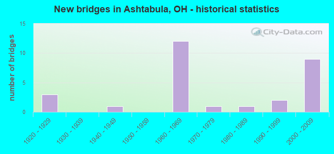
- New bridges - historical statistics
- 31920-1929
- 11940-1949
- 121960-1969
- 11970-1979
- 11980-1989
- 21990-1999
- 92000-2009

- Reconstructed bridges - Historical Statistics
- 11990-1999
- 92000-2009


- Bridge Condition - Deck
- 17.4%Excellent
- 47.8%Very good
- 21.7%Good
- 13.0%Satisfactory

- Bridge Condition - Superstructure
- 17.4%Excellent
- 47.8%Very good
- 26.1%Good
- 8.7%Satisfactory

- Bridge Condition - Substructure
- 13.0%Excellent
- 34.8%Very good
- 39.1%Good
- 13.0%Satisfactory

- Bridge Condition - Channel
- 30.8%Excellent
- 38.5%Very good
- 23.1%Good
- 7.7%Satisfactory

- Bridge Condition - Culverts
- 50.0%Excellent
- 50.0%Very good
Find on map >> Show street view
Structure Number: 401927, Location: 0.83 MI S OF SR 531 (Lat: 41.888731, Lng: -80.781439), Route carried "on" structure: County highway T0399, Year Built: 1963, Status: Open, Structure Length: 6.37m (20.90ft), Average Daily Traffic: 4,143 (year 2016), Truck Traffic: 5%, Average Future Daily Traffic: 5,750 (year 2036), Design Load: HS 20+Mod, Features Intersected: SR 11, Facility Carried by Structure: 21ST STREET TR 399
Minimum Vertical Clearance: 30+ m (98+ ft), Kilometerpoint: 0.412, Lanes on structure: 4, Lanes under structure: 4, Owner: State Highway Agency, Approaching Roadway Width: 18.0m (59.1ft), Skew: 20 degrees, Material/Design: Steel continuous, Design/Construction: Stringer/Multi-beam, Number Of Spans In Main Unit: 4, Length of Maximum Span: 18.3m (60.0ft), Curb or Sidewalk Widths: Left: 1.3m (4.3ft), Right: 1.3m (4.3ft), Curb-To-Curb Width: 18.0m (59.1ft), Out-to-Out Width: 21.1m (69.2ft)
Condition: Deck: Good, Superstructure: Good, Substructure: Good, Operating Rating: 64.8 metric tons, Method Used To Determine Operating Rating: Load Factor (LF) rating reported by rating factor (RF) method using MS18 loading, Inventory Rating: 38.9 metric tons, Method Used To Determine Inventory Rating: Load Factor (LF) rating reported by rating factor (RF) method using MS18 loading, Structural Evaluation: Better than present minimum criteria, Deck Geometry: Somewhat better than minimum adequacy, Underclear: High priority of corrective action, Approach Roadway Alignment: Equal to present desirable criteria, Designated Inspection Frequency: Every 24 months, Inspection Date: December 2021, Deck Structure Type: Concrete Cast-file-Place, Wearing Surface/Protective System: Wearing Surface: Integral Concrete
Find on map >> Show street view
Structure Number: 402168, Location: 4.00 MI E OF SR 45 (Lat: 41.866581, Lng: -80.790250), Route carried "on" structure: US 20, Year Built: 1965, Year Reconstructed: 2005, Status: Open, Structure Length: 6.96m (22.83ft), Average Daily Traffic: 12,153 (year 2015), Truck Traffic: 30%, Average Future Daily Traffic: 16,868 (year 2035), Design Load: HS 20+Mod, Features Intersected: OVER NORFOLK SOUTHERN RR
Minimum Vertical Clearance: 30+ m (98+ ft), Kilometerpoint: 19.537, Lanes on structure: 4, Base Highway Network: Yes, Owner: State Highway Agency, Approaching Roadway Width: 16.7m (54.8ft), Skew: 1 degrees, Material/Design: Steel continuous, Design/Construction: Stringer/Multi-beam, Number Of Spans In Main Unit: 3, Length of Maximum Span: 25.6m (84.0ft), Curb or Sidewalk Widths: Left: 1.6m (5.2ft), Right: 0.0m, Curb-To-Curb Width: 17.3m (56.8ft), Out-to-Out Width: 20.5m (67.3ft)
Condition: Deck: Good, Superstructure: Satisfactory, Substructure: Good, Operating Rating: 42.1 metric tons, Method Used To Determine Operating Rating: Allowable Stress (AS) rating reported by rating factor (RF) method using MS18 loading, Inventory Rating: 32.4 metric tons, Method Used To Determine Inventory Rating: Allowable Stress (AS) rating reported by rating factor (RF) method using MS18 loading, Structural Evaluation: Equal to present minimum criteria, Deck Geometry: Somewhat better than minimum adequacy, Underclear: High priority of corrective action, Approach Roadway Alignment: Equal to present desirable criteria, Designated Inspection Frequency: Every 12 months, Inspection Date: November 2021, Deck Structure Type: Concrete Cast-file-Place, Wearing Surface/Protective System: Wearing Surface: Monolithic Concrete, Deck Protection: Epoxy Coated Reinforcing
Find on map >> Show street view
Structure Number: 402206, Location: 1.00 MI W OF SR 11 (Lat: 41.871761, Lng: -80.780250), Route carried "on" structure: US 20, Year Built: 2000, Status: Open, Structure Length: 37.32m (122.44ft), Average Daily Traffic: 14,871 (year 2015), Truck Traffic: 30%, Average Future Daily Traffic: 20,641 (year 2035), Design Load: HS 20+Mod, Features Intersected: ASHTABULA VIADUCT
Minimum Vertical Clearance: 30+ m (98+ ft), Kilometerpoint: 20.535, Lanes on structure: 4, Base Highway Network: Yes, Owner: State Highway Agency, Approaching Roadway Width: 15.6m (51.2ft), Material/Design: Prestressed concrete continuous, Design/Construction: Stringer/Multi-beam, Number Of Spans In Main Unit: 9, Length of Maximum Span: 45.0m (147.6ft), Curb or Sidewalk Widths: Left: 3.0m (9.8ft), Right: 3.0m (9.8ft), Curb-To-Curb Width: 15.6m (51.2ft), Out-to-Out Width: 23.2m (76.1ft)
Condition: Deck: Very good, Superstructure: Very good, Substructure: Very good, Channel: Good, Operating Rating: 51.8 metric tons, Method Used To Determine Operating Rating: Load and Resistance Factor Rating (LRFR) rating reported by rating factor(RF) method using HL-93 loadings, Inventory Rating: 29.2 metric tons, Method Used To Determine Inventory Rating: Load and Resistance Factor Rating (LRFR) rating reported by rating factor(RF) method using HL-93 loadings, Structural Evaluation: Better than present minimum criteria, Deck Geometry: Meets minimum limits, Waterway Adequacy: Superior to present desirable criteria, Approach Roadway Alignment: Meets minimum limits, Designated Inspection Frequency: Every 24 months, Inspection Date: November 2021, Deck Structure Type: Concrete Cast-file-Place, Wearing Surface/Protective System: Wearing Surface: Monolithic Concrete
Find on map >> Show street view
Structure Number: 402656, Location: 0.08 MI N OF US 20 (Lat: 41.837039, Lng: -80.855619), Route carried "on" structure: State highway 45, Year Built: 2004, Status: Open, Structure Length: 2.09m (6.86ft), Average Daily Traffic: 4,122 (year 2015), Truck Traffic: 11%, Average Future Daily Traffic: 5,721 (year 2035), Design Load: HS 25 or greater, Features Intersected: EAST BR INDIAN CREEK
Minimum Vertical Clearance: 30+ m (98+ ft), Kilometerpoint: 37.643, Lanes on structure: 2, Owner: State Highway Agency, Approaching Roadway Width: 7.3m (24.0ft), Skew: 1 degrees, Material/Design: Prestressed concrete, Design/Construction: Box Beam or Girders - Multiple, Number Of Spans In Main Unit: 1, Length of Maximum Span: 19.8m (65.0ft), Curb-To-Curb Width: 12.2m (40.0ft), Out-to-Out Width: 12.2m (40.0ft)
Condition: Deck: Very good, Superstructure: Very good, Substructure: Very good, Channel: Very good, Operating Rating: 90.7 metric tons, Method Used To Determine Operating Rating: Load Factor (LF) rating reported by rating factor (RF) method using MS18 loading, Inventory Rating: 45.4 metric tons, Method Used To Determine Inventory Rating: Load Factor (LF) rating reported by rating factor (RF) method using MS18 loading, Structural Evaluation: Equal to present desirable criteria, Deck Geometry: Equal to present minimum criteria, Waterway Adequacy: Equal to present desirable criteria, Approach Roadway Alignment: Equal to present desirable criteria, Designated Inspection Frequency: Every 24 months, Inspection Date: October 2021, Deck Structure Type: Concrete Cast-file-Place, Wearing Surface/Protective System: Wearing Surface: Monolithic Concrete, Membrane: Epoxy, Deck Protection: Epoxy Coated Reinforcing
Find on map >> Show street view
Structure Number: 40271, Location: 1.10 MI S OF SR 531 (Lat: 41.864661, Lng: -80.857319), Route carried "on" structure: State highway 45, Year Built: 2005, Status: Open, Structure Length: 0.67m (2.20ft), Average Daily Traffic: 4,122 (year 2015), Truck Traffic: 11%, Average Future Daily Traffic: 5,721 (year 2035), Design Load: HS 25 or greater, Features Intersected: WEST BR RED BROOK
Minimum Vertical Clearance: 30+ m (98+ ft), Kilometerpoint: 40.716, Lanes on structure: 2, Owner: State Highway Agency, Approaching Roadway Width: 4.3m (14.1ft), Skew: 4 degrees, Material/Design: Concrete, Design/Construction: Frame, Number Of Spans In Main Unit: 1, Length of Maximum Span: 6.1m (20.0ft), Curb-To-Curb Width: 8.5m (27.9ft), Out-to-Out Width: 8.5m (27.9ft)
Condition: Deck: Good, Superstructure: Good, Substructure: Good, Channel: Very good, Operating Rating: 42.1 metric tons, Method Used To Determine Operating Rating: Load Factor (LF) rating reported by rating factor (RF) method using MS18 loading, Inventory Rating: 32.4 metric tons, Method Used To Determine Inventory Rating: Load Factor (LF) rating reported by rating factor (RF) method using MS18 loading, Structural Evaluation: Better than present minimum criteria, Deck Geometry: Meets minimum limits, Waterway Adequacy: Superior to present desirable criteria, Approach Roadway Alignment: Equal to present desirable criteria, Designated Inspection Frequency: Every 24 months, Inspection Date: October 2021, Deck Structure Type: Concrete Cast-file-Place, Wearing Surface/Protective System: Wearing Surface: Bituminous, Membrane: Preformed Fabric, Deck Protection: Epoxy Coated Reinforcing
Find on map >> Show street view
Structure Number: 403377, Location: 1.11 MI W OF SR 11 (Lat: 41.865100, Lng: -80.780531), Route carried "on" structure: State highway 84, Year Built: 1986, Status: Open, Structure Length: 28.35m (93.01ft), Average Daily Traffic: 5,783 (year 2015), Truck Traffic: 5%, Average Future Daily Traffic: 8,027 (year 2035), Design Load: HS 20+Mod, Features Intersected: ASHTABULA RIVER
Minimum Vertical Clearance: 30+ m (98+ ft), Kilometerpoint: 22.016, Lanes on structure: 2, Owner: State Highway Agency, Approaching Roadway Width: 12.2m (40.0ft), Material/Design: Steel continuous, Design/Construction: Stringer/Multi-beam, Number Of Spans In Main Unit: 7, Length of Maximum Span: 42.7m (140.1ft), Curb or Sidewalk Widths: Left: 1.5m (4.9ft), Right: 1.5m (4.9ft), Curb-To-Curb Width: 12.2m (40.0ft), Out-to-Out Width: 15.2m (49.9ft)
Condition: Deck: Good, Superstructure: Very good, Substructure: Good, Channel: Very good, Operating Rating: 45.4 metric tons, Method Used To Determine Operating Rating: Load and Resistance Factor Rating (LRFR) rating reported by rating factor(RF) method using HL-93 loadings, Inventory Rating: 35.6 metric tons, Method Used To Determine Inventory Rating: Load and Resistance Factor Rating (LRFR) rating reported by rating factor(RF) method using HL-93 loadings, Structural Evaluation: Better than present minimum criteria, Deck Geometry: Somewhat better than minimum adequacy, Waterway Adequacy: Better than present minimum criteria, Approach Roadway Alignment: Better than present minimum criteria, Designated Inspection Frequency: Every 24 months, Inspection Date: October 2021, Deck Structure Type: Concrete Cast-file-Place, Wearing Surface/Protective System: Wearing Surface: Latex Concrete, Deck Protection: Epoxy Coated Reinforcing
Find on map >> Show street view
Structure Number: 403962, Location: 2.99 MI E OF SR 45 (Lat: 41.813331, Lng: -80.809419), Route carried "on" structure: County highway 199, Year Built: 1960, Year Reconstructed: 2013, Status: Open, Structure Length: 11.40m (37.40ft), Average Daily Traffic: 834 (year 2016), Truck Traffic: 7%, Average Future Daily Traffic: 1,158 (year 2036), Design Load: H 15, Features Intersected: IR 90
Minimum Vertical Clearance: 30+ m (98+ ft), Kilometerpoint: 5.910, Lanes on structure: 2, Lanes under structure: 4, Owner: State Highway Agency, Approaching Roadway Width: 8.5m (27.9ft), Skew: 4 degrees, Material/Design: Steel continuous, Design/Construction: Stringer/Multi-beam, Number Of Spans In Main Unit: 4, Length of Maximum Span: 35.1m (115.2ft), Curb or Sidewalk Widths: Left: 0.6m (2.0ft), Right: 0.6m (2.0ft), Curb-To-Curb Width: 8.5m (27.9ft), Out-to-Out Width: 9.4m (30.8ft)
Condition: Deck: Very good, Superstructure: Good, Substructure: Good, Operating Rating: 42.1 metric tons, Method Used To Determine Operating Rating: Load Factor (LF) rating reported by rating factor (RF) method using MS18 loading, Inventory Rating: 29.2 metric tons, Method Used To Determine Inventory Rating: Load Factor (LF) rating reported by rating factor (RF) method using MS18 loading, Structural Evaluation: Better than present minimum criteria, Deck Geometry: Somewhat better than minimum adequacy, Underclear: High priority of corrective action, Approach Roadway Alignment: Equal to present desirable criteria, Designated Inspection Frequency: Every 24 months, Inspection Date: November 2021, Deck Structure Type: Concrete Cast-file-Place, Wearing Surface/Protective System: Wearing Surface: Monolithic Concrete, Deck Protection: Epoxy Coated Reinforcing
Find on map >> Show street view
Structure Number: 403997, Location: 1.00 MI W OF SR 11 (Lat: 41.827639, Lng: -80.784931), Route carried "on" structure: County highway 150, Year Built: 1960, Year Reconstructed: 2014, Status: Open, Structure Length: 8.08m (26.51ft), Average Daily Traffic: 1,772 (year 2016), Truck Traffic: 7%, Average Future Daily Traffic: 2,460 (year 2036), Design Load: H 15, Features Intersected: 00090
Minimum Vertical Clearance: 30+ m (98+ ft), Kilometerpoint: 3.718, Lanes on structure: 2, Lanes under structure: 4, Owner: State Highway Agency, Approaching Roadway Width: 9.1m (29.9ft), Material/Design: Steel continuous, Design/Construction: Stringer/Multi-beam, Number Of Spans In Main Unit: 4, Length of Maximum Span: 24.1m (79.1ft), Curb or Sidewalk Widths: Left: 0.6m (2.0ft), Right: 0.6m (2.0ft), Curb-To-Curb Width: 9.1m (29.9ft), Out-to-Out Width: 10.1m (33.1ft)
Condition: Deck: Very good, Superstructure: Good, Substructure: Good, Operating Rating: 45.4 metric tons, Method Used To Determine Operating Rating: Load and Resistance Factor Rating (LRFR) rating reported by rating factor(RF) method using HL-93 loadings, Inventory Rating: 32.4 metric tons, Method Used To Determine Inventory Rating: Load and Resistance Factor Rating (LRFR) rating reported by rating factor(RF) method using HL-93 loadings, Structural Evaluation: Better than present minimum criteria, Deck Geometry: Somewhat better than minimum adequacy, Underclear: High priority of corrective action, Approach Roadway Alignment: Equal to present desirable criteria, Designated Inspection Frequency: Every 24 months, Inspection Date: November 2021, Deck Structure Type: Concrete Cast-file-Place, Wearing Surface/Protective System: Wearing Surface: Monolithic Concrete
Find on map >> Show street view
Structure Number: 406597, Location: 0.40 MI E OF SR 45 (Lat: 41.884300, Lng: -80.850869), Route carried "on" structure: State highway 531, Year Built: 1994, Status: Open, Structure Length: 0.82m (2.69ft), Average Daily Traffic: 4,034 (year 2015), Truck Traffic: 5%, Average Future Daily Traffic: 5,599 (year 2035), Design Load: HS 20+Mod, Features Intersected: RED BROOK
Minimum Vertical Clearance: 30+ m (98+ ft), Kilometerpoint: 9.608, Lanes on structure: 2, Owner: State Highway Agency, Approaching Roadway Width: 12.2m (40.0ft), Skew: 1 degrees, Material/Design: Concrete, Design/Construction: Culvert, Number Of Spans In Main Unit: 1, Length of Maximum Span: 7.3m (24.0ft)
Condition: Channel: Very good, Culverts: Very good, Operating Rating: 97.2 metric tons, Method Used To Determine Operating Rating: Load Factor (LF) rating reported by rating factor (RF) method using MS18 loading, Inventory Rating: 68.0 metric tons, Method Used To Determine Inventory Rating: Load Factor (LF) rating reported by rating factor (RF) method using MS18 loading, Structural Evaluation: Equal to present desirable criteria, Waterway Adequacy: Superior to present desirable criteria, Approach Roadway Alignment: Superior to present desirable criteria, Designated Inspection Frequency: Every 24 months, Inspection Date: November 2021
Find on map >> Show street view
Structure Number: 406635, Location: 0.85 MI W OF SR 11 (Lat: 41.900261, Lng: -80.797769), Route carried "on" structure: State highway 531, Year Built: 1925, Year Reconstructed: 2008, Status: Open, Structure Length: 6.80m (22.31ft), Average Daily Traffic: 6,767 (year 2015), Truck Traffic: 5%, Average Future Daily Traffic: 9,393 (year 2035), Design Load: HS 20, Features Intersected: ASHTABULA RIVER
Minimum Vertical Clearance: 4.22m (13.85ft), Kilometerpoint: 14.758, Lanes on structure: 2, Owner: State Highway Agency, Approaching Roadway Width: 6.1m (20.0ft), Navigation Control: Yes ( Vertical Clearance: 2.1m (6.9ft), Horizontal Clearance: 38.1m (125.0ft)), Material/Design: Steel, Design/Construction: Movable - Bascule, Number Of Spans In Main Unit: 2, Number Of Approach Spans: 1, Length of Maximum Span: 48.6m (159.4ft), Curb or Sidewalk Widths: Left: 1.5m (4.9ft), Right: 1.5m (4.9ft), Curb-To-Curb Width: 6.1m (20.0ft), Out-to-Out Width: 7.3m (24.0ft)
Condition: Deck: Good, Superstructure: Good, Substructure: Satisfactory, Channel: Good, Operating Rating: 32.4 metric tons, Method Used To Determine Operating Rating: Load Factor (LF) rating reported by rating factor (RF) method using MS18 loading, Inventory Rating: 19.4 metric tons, Method Used To Determine Inventory Rating: Load Factor (LF) rating reported by rating factor (RF) method using MS18 loading, Structural Evaluation: Meets minimum limits, Deck Geometry: High priority of replacement, Waterway Adequacy: Equal to present desirable criteria, Approach Roadway Alignment: Equal to present minimum criteria, Designated Inspection Frequency: Every 12 months, Critical Feature Inspection Frequency: Every 24 months, Underwater Inspection Frequency: Every 60 months, Inspection Date: October 2021, Critical Feature Inspection Date: December 2020, Underwater Inspection Date: July 2020, Deck Structure Type: Closed Grating, Wearing Surface/Protective System: Wearing Surface: Integral Concrete, Membrane: Epoxy, Deck Protection: Epoxy Coated Reinforcing
Find on map >> Show street view
Structure Number: 406694, Location: 0.59 MI W OF SR 11 (Lat: 41.900250, Lng: -80.793581), Route carried "on" structure: State highway 531, Year Built: 1961, Year Reconstructed: 1998, Status: Open, Structure Length: 9.91m (32.51ft), Average Daily Traffic: 6,767 (year 2015), Truck Traffic: 5%, Average Future Daily Traffic: 9,393 (year 2035), Design Load: HS 20+Mod, Features Intersected: OVER NORFOLK SOUTHERN RR
Minimum Vertical Clearance: 30+ m (98+ ft), Kilometerpoint: 15.176, Lanes on structure: 2, Owner: State Highway Agency, Approaching Roadway Width: 8.5m (27.9ft), Skew: 5 degrees, Material/Design: Steel continuous, Design/Construction: Stringer/Multi-beam, Number Of Spans In Main Unit: 5, Length of Maximum Span: 25.0m (82.0ft), Curb or Sidewalk Widths: Left: 1.3m (4.3ft), Right: 0.0m, Curb-To-Curb Width: 8.5m (27.9ft), Out-to-Out Width: 10.8m (35.4ft)
Condition: Deck: Very good, Superstructure: Very good, Substructure: Very good, Operating Rating: 42.1 metric tons, Method Used To Determine Operating Rating: Allowable Stress (AS) rating reported by rating factor (RF) method using MS18 loading, Inventory Rating: 32.4 metric tons, Method Used To Determine Inventory Rating: Allowable Stress (AS) rating reported by rating factor (RF) method using MS18 loading, Structural Evaluation: Equal to present desirable criteria, Deck Geometry: Meets minimum limits, Underclear: High priority of corrective action, Approach Roadway Alignment: Equal to present desirable criteria, Designated Inspection Frequency: Every 24 months, Inspection Date: September 2021, Deck Structure Type: Concrete Cast-file-Place, Wearing Surface/Protective System: Wearing Surface: Monolithic Concrete, Deck Protection: Epoxy Coated Reinforcing
Find on map >> Show street view
Structure Number: 406724, Location: 0.98 MI E OF SR 11 (Lat: 41.908269, Lng: -80.766339), Route carried "on" structure: State highway 531, Year Built: 1929, Year Reconstructed: 2011, Status: Open, Structure Length: 1.16m (3.81ft), Average Daily Traffic: 4,027 (year 2015), Truck Traffic: 9%, Average Future Daily Traffic: 5,589 (year 2035), Design Load: HS 20+Mod, Features Intersected: OVR FIRST ENERGY RR SPUR
Minimum Vertical Clearance: 30+ m (98+ ft), Kilometerpoint: 17.719, Lanes on structure: 2, Owner: Private, Approaching Roadway Width: 7.3m (24.0ft), Skew: 2 degrees, Material/Design: Prestressed concrete, Design/Construction: Box Beam or Girders - Multiple, Number Of Spans In Main Unit: 1, Length of Maximum Span: 11.6m (38.1ft), Curb-To-Curb Width: 14.0m (45.9ft), Out-to-Out Width: 14.9m (48.9ft)
Condition: Deck: Very good, Superstructure: Very good, Substructure: Very good, Operating Rating: 97.2 metric tons, Method Used To Determine Operating Rating: Load Factor (LF) rating reported by rating factor (RF) method using MS18 loading, Inventory Rating: 74.5 metric tons, Method Used To Determine Inventory Rating: Load Factor (LF) rating reported by rating factor (RF) method using MS18 loading, Structural Evaluation: Equal to present desirable criteria, Deck Geometry: Superior to present desirable criteria, Underclear: Meets minimum limits, Approach Roadway Alignment: Equal to present desirable criteria, Designated Inspection Frequency: Every 24 months, Inspection Date: September 2021, Deck Structure Type: Concrete Cast-file-Place, Wearing Surface/Protective System: Wearing Surface: Monolithic Concrete, Deck Protection: Epoxy Coated Reinforcing
Find on map >> Show street view
Structure Number: 406759, Location: 1.42 MI E OF SR 11 (Lat: 41.911531, Lng: -80.759189), Route carried "on" structure: State highway 531, Year Built: 1947, Year Reconstructed: 2011, Status: Open, Structure Length: 3.29m (10.79ft), Average Daily Traffic: 4,221 (year 2015), Truck Traffic: 4%, Average Future Daily Traffic: 5,859 (year 2035), Design Load: HS 15, Features Intersected: OVER PRIVATE ABANDONED R
Minimum Vertical Clearance: 30+ m (98+ ft), Kilometerpoint: 18.524, Lanes on structure: 2, Owner: Private, Approaching Roadway Width: 7.3m (24.0ft), Material/Design: Concrete continuous, Design/Construction: Slab, Number Of Spans In Main Unit: 3, Length of Maximum Span: 11.6m (38.1ft), Curb or Sidewalk Widths: Left: 1.2m (3.9ft), Right: 1.2m (3.9ft), Curb-To-Curb Width: 11.8m (38.7ft), Out-to-Out Width: 14.6m (47.9ft)
Condition: Deck: Satisfactory, Superstructure: Satisfactory, Substructure: Satisfactory, Operating Rating: 38.9 metric tons, Method Used To Determine Operating Rating: Load Factor (LF) rating reported by rating factor (RF) method using MS18 loading, Inventory Rating: 22.7 metric tons, Method Used To Determine Inventory Rating: Load Factor (LF) rating reported by rating factor (RF) method using MS18 loading, Structural Evaluation: Equal to present minimum criteria, Deck Geometry: Somewhat better than minimum adequacy, Underclear: Meets minimum limits, Approach Roadway Alignment: Equal to present desirable criteria, Designated Inspection Frequency: Every 12 months, Inspection Date: September 2021, Deck Structure Type: Concrete Cast-file-Place, Wearing Surface/Protective System: Wearing Surface: Bituminous
Find on map >> Show street view
Structure Number: 431516, Location: .2 MI S OF SCHENLEY (Lat: 41.873081, Lng: -80.781831), Route carried "on" structure: County highway T030A, Year Built: 2007, Status: Open, Structure Length: 4.69m (15.39ft), Average Daily Traffic: 781 (year 2015), Truck Traffic: 5%, Average Future Daily Traffic: 1,084 (year 2035), Design Load: HS 20, Features Intersected: ASHTABULA RIVER, Facility Carried by Structure: HARMON HILL ROAD
Minimum Vertical Clearance: 30+ m (98+ ft), Kilometerpoint: 0.322, Lanes on structure: 2, Owner: County Highway Agency, Approaching Roadway Width: 6.1m (20.0ft), Material/Design: Steel, Design/Construction: Truss - Thru, Number Of Spans In Main Unit: 1, Length of Maximum Span: 45.7m (149.9ft), Curb or Sidewalk Widths: Left: 1.5m (4.9ft), Right: 0.0m, Curb-To-Curb Width: 8.5m (27.9ft), Out-to-Out Width: 8.5m (27.9ft)
Condition: Deck: Very good, Superstructure: Very good, Substructure: Very good, Channel: Excellent, Operating Rating: 61.6 metric tons, Method Used To Determine Operating Rating: Load Factor (LF) rating reported by rating factor (RF) method using MS18 loading, Inventory Rating: 38.9 metric tons, Method Used To Determine Inventory Rating: Load Factor (LF) rating reported by rating factor (RF) method using MS18 loading, Structural Evaluation: Equal to present desirable criteria, Deck Geometry: Somewhat better than minimum adequacy, Waterway Adequacy: Equal to present desirable criteria, Approach Roadway Alignment: Better than present minimum criteria, Designated Inspection Frequency: Every 12 months, Critical Feature Inspection Frequency: Every 24 months, Inspection Date: May 2021, Critical Feature Inspection Date: May 2021, Deck Structure Type: Wood or Timber, Wearing Surface/Protective System: Wearing Surface: Bituminous
Find on map >> Show street view
Structure Number: 431524, Location: .56 MI N OF PLYMOUTH RIDG (Lat: 41.855550, Lng: -80.761769), Route carried "on" structure: County highway C025G, Year Built: 2008, Status: Open, Structure Length: 18.68m (61.29ft), Average Daily Traffic: 2,054 (year 2015), Truck Traffic: 3%, Average Future Daily Traffic: 2,851 (year 2035), Design Load: HS 25 or greater, Features Intersected: ASHTABULA RIVER, Facility Carried by Structure: STATE ROAD
Minimum Vertical Clearance: 4.42m (14.50ft), Kilometerpoint: 5.778, Lanes on structure: 2, Owner: County Highway Agency, Approaching Roadway Width: 8.5m (27.9ft), Material/Design: Wood or Timber, Design/Construction: Truss - Thru, Number Of Spans In Main Unit: 4, Length of Maximum Span: 46.5m (152.6ft), Curb or Sidewalk Widths: Left: 1.6m (5.2ft), Right: 1.6m (5.2ft), Curb-To-Curb Width: 9.2m (30.2ft), Out-to-Out Width: 9.8m (32.2ft)
Condition: Deck: Excellent, Superstructure: Excellent, Substructure: Excellent, Channel: Excellent, Operating Rating: 35.6 metric tons, Method Used To Determine Operating Rating: Allowable Stress (AS) rating reported by rating factor (RF) method using MS18 loading, Inventory Rating: 22.7 metric tons, Method Used To Determine Inventory Rating: Allowable Stress (AS) rating reported by rating factor (RF) method using MS18 loading, Structural Evaluation: Equal to present minimum criteria, Deck Geometry: Meets minimum limits, Waterway Adequacy: Superior to present desirable criteria, Approach Roadway Alignment: Superior to present desirable criteria, Designated Inspection Frequency: Every 24 months, Inspection Date: May 2021, Deck Structure Type: Wood or Timber, Wearing Surface/Protective System: Wearing Surface: Wood or Timber, Deck Protection: Other
Find on map >> Show street view
Structure Number: 431532, Location: 1000 FT N OF MIDDLE ROAD (Lat: 41.893100, Lng: -80.772469), Route carried "on" structure: County highway C025L, Year Built: 2009, Status: Open, Structure Length: 1.04m (3.41ft), Average Daily Traffic: 1,718 (year 2015), Truck Traffic: 3%, Average Future Daily Traffic: 2,385 (year 2035), Design Load: HS 25 or greater, Features Intersected: FIELDS BROOK, Facility Carried by Structure: STATE ROAD
Minimum Vertical Clearance: 30+ m (98+ ft), Kilometerpoint: 10.702, Lanes on structure: 2, Owner: County Highway Agency, Approaching Roadway Width: 6.1m (20.0ft), Material/Design: Concrete, Design/Construction: Culvert, Number Of Spans In Main Unit: 1, Length of Maximum Span: 10.1m (33.1ft)
Condition: Channel: Excellent, Culverts: Excellent, Operating Rating: 51.8 metric tons, Method Used To Determine Operating Rating: Load Factor (LF) rating reported by rating factor (RF) method using MS18 loading, Inventory Rating: 38.9 metric tons, Method Used To Determine Inventory Rating: Load Factor (LF) rating reported by rating factor (RF) method using MS18 loading, Structural Evaluation: Superior to present desirable criteria, Waterway Adequacy: Superior to present desirable criteria, Approach Roadway Alignment: Superior to present desirable criteria, Designated Inspection Frequency: Every 24 months, Inspection Date: May 2021
Find on map >> Show street view
Structure Number: 431575, Location: .34 MI E OF DEPOT ROAD (Lat: 41.840000, Lng: -80.865561), Route carried "on" structure: County highway T217E, Year Built: 2008, Status: Open, Structure Length: 1.37m (4.49ft), Average Daily Traffic: 429 (year 2015), Truck Traffic: 15%, Average Future Daily Traffic: 595 (year 2035), Design Load: HS 25 or greater, Features Intersected: INDIAN CREEK, Facility Carried by Structure: NEW LONDON ROAD
Minimum Vertical Clearance: 30+ m (98+ ft), Kilometerpoint: 7.435, Lanes on structure: 2, Owner: County Highway Agency, Approaching Roadway Width: 6.7m (22.0ft), Material/Design: Concrete continuous, Design/Construction: Frame, Number Of Spans In Main Unit: 3, Length of Maximum Span: 4.9m (16.1ft), Curb-To-Curb Width: 9.8m (32.2ft), Out-to-Out Width: 9.8m (32.2ft)
Condition: Deck: Excellent, Superstructure: Excellent, Substructure: Excellent, Channel: Satisfactory, Operating Rating: 68.0 metric tons, Method Used To Determine Operating Rating: Load Factor (LF) rating reported by rating factor (RF) method using MS18 loading, Inventory Rating: 42.1 metric tons, Method Used To Determine Inventory Rating: Load Factor (LF) rating reported by rating factor (RF) method using MS18 loading, Structural Evaluation: Superior to present desirable criteria, Deck Geometry: Equal to present minimum criteria, Waterway Adequacy: Superior to present desirable criteria, Approach Roadway Alignment: Superior to present desirable criteria, Designated Inspection Frequency: Every 24 months, Inspection Date: May 2021, Deck Structure Type: Concrete Cast-file-Place, Wearing Surface/Protective System: Wearing Surface: Monolithic Concrete
Find on map >> Show street view
Structure Number: 433667, Location: 0.0 MILE E OF TWP LINE (Lat: 41.854431, Lng: -80.782561), Route carried "on" structure: County highway 20, Year Built: 2003, Status: Open, Structure Length: 3.76m (12.34ft), Average Daily Traffic: 1,045 (year 2015), Truck Traffic: 5%, Average Future Daily Traffic: 1,450 (year 2035), Design Load: HS 20, Features Intersected: NORFOLK SOUTHERN, Facility Carried by Structure: PLYMOUTH RIDGE RD
Minimum Vertical Clearance: 30+ m (98+ ft), Kilometerpoint: 0.129, Lanes on structure: 2, Owner: County Highway Agency, Approaching Roadway Width: 9.1m (29.9ft), Skew: 5 degrees, Material/Design: Steel, Design/Construction: Stringer/Multi-beam, Number Of Spans In Main Unit: 1, Length of Maximum Span: 36.6m (120.1ft), Curb or Sidewalk Widths: Left: 1.2m (3.9ft), Right: 0.0m, Curb-To-Curb Width: 9.1m (29.9ft), Out-to-Out Width: 11.1m (36.4ft)
Condition: Deck: Excellent, Superstructure: Excellent, Substructure: Very good, Operating Rating: 97.2 metric tons, Method Used To Determine Operating Rating: Load Factor (LF) rating reported by rating factor (RF) method using MS18 loading, Inventory Rating: 61.6 metric tons, Method Used To Determine Inventory Rating: Load Factor (LF) rating reported by rating factor (RF) method using MS18 loading, Structural Evaluation: Equal to present desirable criteria, Deck Geometry: Somewhat better than minimum adequacy, Underclear: Equal to present desirable criteria, Approach Roadway Alignment: Superior to present desirable criteria, Designated Inspection Frequency: Every 24 months, Inspection Date: May 2021, Deck Structure Type: Concrete Cast-file-Place, Wearing Surface/Protective System: Wearing Surface: Monolithic Concrete, Deck Protection: Galvanized Reinforcing
Find on map >> Show street view
Structure Number: 433691, Location: 250 E. OF CORP. LIMIT (Lat: 41.848400, Lng: -80.781461), Route carried "on" structure: County highway C023A, Year Built: 1978, Status: Open, Structure Length: 7.70m (25.26ft), Average Daily Traffic: 353 (year 2015), Truck Traffic: 5%, Average Future Daily Traffic: 490 (year 2035), Design Load: HS 20+Mod, Features Intersected: HUBBARD RUN, Facility Carried by Structure: RUNKLE AVENUE
Minimum Vertical Clearance: 30+ m (98+ ft), Kilometerpoint: 0.595, Lanes on structure: 2, Owner: County Highway Agency, Approaching Roadway Width: 6.1m (20.0ft), Material/Design: Steel, Design/Construction: Truss - Thru, Number Of Spans In Main Unit: 3, Length of Maximum Span: 39.2m (128.6ft), Curb-To-Curb Width: 7.6m (24.9ft), Out-to-Out Width: 7.6m (24.9ft)
Condition: Deck: Satisfactory, Superstructure: Very good, Substructure: Satisfactory, Channel: Very good, Operating Rating: 51.8 metric tons, Method Used To Determine Operating Rating: Load Factor (LF) rating reported by rating factor (RF) method using MS18 loading, Inventory Rating: 32.4 metric tons, Method Used To Determine Inventory Rating: Load Factor (LF) rating reported by rating factor (RF) method using MS18 loading, Structural Evaluation: Equal to present minimum criteria, Deck Geometry: Somewhat better than minimum adequacy, Waterway Adequacy: Superior to present desirable criteria, Approach Roadway Alignment: Equal to present minimum criteria, Designated Inspection Frequency: Every 12 months, Critical Feature Inspection Frequency: Every 24 months, Inspection Date: May 2021, Critical Feature Inspection Date: May 2021, Deck Structure Type: Wood or Timber, Wearing Surface/Protective System: Wearing Surface: Bituminous
Find on map >> Show street view
Structure Number: 439711, Location: .23 MI E OF RENKO RD (Lat: 41.873961, Lng: -80.840089), Route carried "on" structure: County highway T239A, Year Built: 1992, Status: Open, Structure Length: 0.98m (3.22ft), Average Daily Traffic: 843 (year 2015), Truck Traffic: 5%, Average Future Daily Traffic: 1,170 (year 2035), Design Load: HS 20, Features Intersected: UNNAMED STREAM, Facility Carried by Structure: WADE AVENUE
Minimum Vertical Clearance: 30+ m (98+ ft), Kilometerpoint: 0.370, Lanes on structure: 2, Owner: County Highway Agency, Approaching Roadway Width: 6.1m (20.0ft), Skew: 3 degrees, Material/Design: Prestressed concrete, Design/Construction: Box Beam or Girders - Multiple, Number Of Spans In Main Unit: 1, Length of Maximum Span: 8.8m (28.9ft), Curb-To-Curb Width: 7.3m (24.0ft), Out-to-Out Width: 7.3m (24.0ft)
Condition: Deck: Excellent, Superstructure: Excellent, Substructure: Excellent, Channel: Excellent, Operating Rating: 77.8 metric tons, Method Used To Determine Operating Rating: Load Factor (LF) rating reported by rating factor (RF) method using MS18 loading, Inventory Rating: 45.4 metric tons, Method Used To Determine Inventory Rating: Load Factor (LF) rating reported by rating factor (RF) method using MS18 loading, Structural Evaluation: Superior to present desirable criteria, Deck Geometry: Meets minimum limits, Waterway Adequacy: Superior to present desirable criteria, Approach Roadway Alignment: Superior to present desirable criteria, Designated Inspection Frequency: Every 24 months, Inspection Date: May 2021, Deck Structure Type: Concrete Cast-file-Place, Wearing Surface/Protective System: Wearing Surface: Bituminous
Find on map >> Show street view
Structure Number: 460028, Location: 0.68 MI N OF US20 (Lat: 41.873231, Lng: -80.799511), Route carried "on" structure: County highway C0900, Year Built: 1969, Year Reconstructed: 2014, Status: Open, Structure Length: 3.90m (12.80ft), Average Daily Traffic: 1,691 (year 2015), Truck Traffic: 5%, Average Future Daily Traffic: 2,347 (year 2035), Design Load: HS 20, Features Intersected: W 30TH STREET, Facility Carried by Structure: WEST AVENUE
Minimum Vertical Clearance: 30+ m (98+ ft), Kilometerpoint: 2.520, Lanes on structure: 4, Lanes under structure: 2, Owner: City or Municipal Highway Agency, Approaching Roadway Width: 15.9m (52.2ft), Material/Design: Steel continuous, Design/Construction: Stringer/Multi-beam, Number Of Spans In Main Unit: 3, Length of Maximum Span: 15.5m (50.9ft), Curb or Sidewalk Widths: Left: 1.8m (5.9ft), Right: 1.8m (5.9ft), Curb-To-Curb Width: 15.9m (52.2ft), Out-to-Out Width: 20.1m (65.9ft)
Condition: Deck: Very good, Superstructure: Very good, Substructure: Very good, Operating Rating: 71.3 metric tons, Method Used To Determine Operating Rating: Load Factor (LF) rating reported by rating factor (RF) method using MS18 loading, Inventory Rating: 42.1 metric tons, Method Used To Determine Inventory Rating: Load Factor (LF) rating reported by rating factor (RF) method using MS18 loading, Structural Evaluation: Equal to present desirable criteria, Deck Geometry: Meets minimum limits, Underclear: Meets minimum limits, Approach Roadway Alignment: Equal to present desirable criteria, Designated Inspection Frequency: Every 24 months, Inspection Date: July 2021, Deck Structure Type: Concrete Cast-file-Place, Wearing Surface/Protective System: Wearing Surface: Monolithic Concrete
Find on map >> Show street view
Structure Number: 460036, Location: 0.1 mi.N of W34th St (Lat: 41.872031, Lng: -80.799211), Route carried "on" structure: County highway C0900, Year Built: 1969, Year Reconstructed: 2014, Status: Open, Structure Length: 10.00m (32.81ft), Average Daily Traffic: 4,139 (year 2015), Truck Traffic: 7%, Average Future Daily Traffic: 5,745 (year 2035), Design Load: HS 20+Mod, Features Intersected: CONRAIL RR, Facility Carried by Structure: WEST AVENUE
Minimum Vertical Clearance: 30+ m (98+ ft), Kilometerpoint: 2.913, Lanes on structure: 4, Owner: City or Municipal Highway Agency, Approaching Roadway Width: 15.9m (52.2ft), Skew: 2 degrees, Material/Design: Steel continuous, Design/Construction: Stringer/Multi-beam, Number Of Spans In Main Unit: 4, Length of Maximum Span: 29.9m (98.1ft), Curb or Sidewalk Widths: Left: 1.8m (5.9ft), Right: 0.6m (2.0ft), Curb-To-Curb Width: 15.9m (52.2ft), Out-to-Out Width: 18.9m (62.0ft)
Condition: Deck: Very good, Superstructure: Good, Substructure: Good, Operating Rating: 58.3 metric tons, Method Used To Determine Operating Rating: Load Factor (LF) rating reported by rating factor (RF) method using MS18 loading, Inventory Rating: 35.6 metric tons, Method Used To Determine Inventory Rating: Load Factor (LF) rating reported by rating factor (RF) method using MS18 loading, Structural Evaluation: Better than present minimum criteria, Deck Geometry: Meets minimum limits, Underclear: Meets minimum limits, Approach Roadway Alignment: Equal to present desirable criteria, Designated Inspection Frequency: Every 24 months, Inspection Date: July 2021, Deck Structure Type: Concrete Cast-file-Place, Wearing Surface/Protective System: Wearing Surface: Monolithic Concrete
Find on map >> Show street view
Structure Number: 460044, Location: .2 mi NE of Lake & 24th (Lat: 41.882319, Lng: -80.794739), Route carried "on" structure: County highway C0905, Year Built: 1965, Status: Open, Structure Length: 6.89m (22.60ft), Average Daily Traffic: 5,750 (year 2015), Truck Traffic: 5%, Average Future Daily Traffic: 7,981 (year 2035), Design Load: HS 25 or greater, Features Intersected: ASHTABULA RIVER, Facility Carried by Structure: E 24TH STREET
Minimum Vertical Clearance: 30+ m (98+ ft), Kilometerpoint: 1.271, Lanes on structure: 2, Owner: City or Municipal Highway Agency, Approaching Roadway Width: 8.5m (27.9ft), Material/Design: Steel continuous, Design/Construction: Stringer/Multi-beam, Number Of Spans In Main Unit: 3, Length of Maximum Span: 25.9m (85.0ft), Curb or Sidewalk Widths: Left: 1.6m (5.2ft), Right: 0.0m, Curb-To-Curb Width: 8.5m (27.9ft), Out-to-Out Width: 11.4m (37.4ft)
Condition: Deck: Satisfactory, Superstructure: Very good, Substructure: Good, Channel: Good, Operating Rating: 94.0 metric tons, Method Used To Determine Operating Rating: Load Factor (LF) rating reported by rating factor (RF) method using MS18 loading, Inventory Rating: 58.3 metric tons, Method Used To Determine Inventory Rating: Load Factor (LF) rating reported by rating factor (RF) method using MS18 loading, Structural Evaluation: Better than present minimum criteria, Deck Geometry: Meets minimum limits, Waterway Adequacy: Better than present minimum criteria, Approach Roadway Alignment: Equal to present desirable criteria, Designated Inspection Frequency: Every 12 months, Inspection Date: July 2021, Deck Structure Type: Concrete Cast-file-Place, Wearing Surface/Protective System: Wearing Surface: Monolithic Concrete
Find on map >> Show street view
Structure Number: 460052, Location: 1.31 MI NW OF US20 (Lat: 41.884111, Lng: -80.801711), Route carried "on" structure: County highway C0904, Year Built: 1928, Year Reconstructed: 2011, Status: Open, Structure Length: 2.59m (8.50ft), Average Daily Traffic: 9,547 (year 2015), Truck Traffic: 4%, Average Future Daily Traffic: 29,148 (year 2035), Design Load: HS 20+Mod, Features Intersected: CONRAIL RR, Facility Carried by Structure: LAKE AVENUE
Minimum Vertical Clearance: 30+ m (98+ ft), Kilometerpoint: 4.249, Lanes on structure: 3, Owner: Railroad, Approaching Roadway Width: 11.0m (36.1ft), Skew: 6 degrees, Material/Design: Steel, Design/Construction: Stringer/Multi-beam, Number Of Spans In Main Unit: 1, Length of Maximum Span: 25.9m (85.0ft), Curb or Sidewalk Widths: Left: 1.5m (4.9ft), Right: 0.0m, Curb-To-Curb Width: 11.0m (36.1ft), Out-to-Out Width: 18.1m (59.4ft)
Condition: Deck: Very good, Superstructure: Very good, Substructure: Good, Operating Rating: 55.1 metric tons, Method Used To Determine Operating Rating: Load Factor (LF) rating reported by rating factor (RF) method using MS18 loading, Inventory Rating: 32.4 metric tons, Method Used To Determine Inventory Rating: Load Factor (LF) rating reported by rating factor (RF) method using MS18 loading, Structural Evaluation: Better than present minimum criteria, Deck Geometry: High priority of replacement, Underclear: High priority of corrective action, Approach Roadway Alignment: Meets minimum limits, Designated Inspection Frequency: Every 24 months, Inspection Date: July 2021, Deck Structure Type: Concrete Cast-file-Place, Wearing Surface/Protective System: Wearing Surface: Monolithic Concrete
Find on map >> Show street view
Structure Number: 460087, Location: 0.2MI S OF W 52 STREET (Lat: 41.859639, Lng: -80.795939), Route carried "on" structure: County highway C0900, Year Built: 2007, Status: Open, Structure Length: 3.51m (11.52ft), Average Daily Traffic: 4,139 (year 2015), Truck Traffic: 7%, Average Future Daily Traffic: 5,745 (year 2035), Design Load: HL 93, Features Intersected: NORFOLK S. RAILROAD, Facility Carried by Structure: WEST AVENUE
Minimum Vertical Clearance: 30+ m (98+ ft), Kilometerpoint: 0.966, Lanes on structure: 2, Owner: City or Municipal Highway Agency, Approaching Roadway Width: 8.5m (27.9ft), Skew: 2 degrees, Material/Design: Prestressed concrete, Design/Construction: Stringer/Multi-beam, Number Of Spans In Main Unit: 1, Length of Maximum Span: 33.5m (109.9ft), Curb or Sidewalk Widths: Left: 2.4m (7.9ft), Right: 2.4m (7.9ft), Curb-To-Curb Width: 8.5m (27.9ft), Out-to-Out Width: 14.0m (45.9ft)
Condition: Deck: Very good, Superstructure: Very good, Substructure: Very good, Operating Rating: 57.3 metric tons, Method Used To Determine Operating Rating: Load and Resistance Factor Rating (LRFR) rating reported by rating factor(RF) method using HL-93 loadings, Inventory Rating: 33.4 metric tons, Method Used To Determine Inventory Rating: Load and Resistance Factor Rating (LRFR) rating reported by rating factor(RF) method using HL-93 loadings, Structural Evaluation: Equal to present desirable criteria, Deck Geometry: Meets minimum limits, Underclear: High priority of corrective action, Approach Roadway Alignment: Meets minimum limits, Designated Inspection Frequency: Every 24 months, Inspection Date: July 2021, Deck Structure Type: Concrete Cast-file-Place, Wearing Surface/Protective System: Wearing Surface: Monolithic Concrete
Find on map >> Show street view
Structure Number: 401927, Location: 0.83 MI S OF SR 531 (Lat: 41.888731, Lng: -80.781439), Route carried "under" structure: State highway 11, Year Built: 1963, Structure Length: 0. m, Average Daily Traffic: 8,153 (year 2016), Truck Traffic: 4%, Features Intersected: 21ST STREET TR-399, Facility Carried by Structure: 21ST STREET TR 399
Minimum Vertical Clearance: 4.90m (16.08ft), Kilometerpoint: 45.398, Lanes on structure: 4, Lanes under structure: 4, Material/Design: Steel continuous, Design/Construction: Stringer/Multi-beam, Length of Maximum Span: 18.3m (60.0ft)
Find on map >> Show street view
Structure Number: 403962, Location: 2.99 MI E OF SR 45 (Lat: 41.813331, Lng: -80.809419), Route carried "under" structure: Interstate 90, Year Built: 1960, Structure Length: 0. m, Average Daily Traffic: 25,152 (year 2016), Truck Traffic: 34%, Features Intersected: CHAPEL RD CR-199, Facility Carried by Structure: CHAPEL ROAD CR-199
Minimum Vertical Clearance: 5.09m (16.70ft), Kilometerpoint: 17.671, Lanes on structure: 2, Lanes under structure: 4, Material/Design: Steel continuous, Design/Construction: Stringer/Multi-beam, Length of Maximum Span: 35.1m (115.2ft)
Find on map >> Show street view
Structure Number: 403997, Location: 1.00 MI W OF SR 11 (Lat: 41.827639, Lng: -80.784931), Route carried "under" structure: Interstate 90, Year Built: 1960, Structure Length: 0. m, Average Daily Traffic: 25,152 (year 2016), Truck Traffic: 34%, Features Intersected: JEFFERSON RD CR-150, Facility Carried by Structure: JEFFERSON RD C150
Minimum Vertical Clearance: 5.13m (16.83ft), Kilometerpoint: 20.305, Lanes on structure: 2, Lanes under structure: 4, Material/Design: Steel continuous, Design/Construction: Stringer/Multi-beam, Length of Maximum Span: 24.1m (79.1ft)
Find on map >> Show street view
Structure Number: 460028, Location: 0.68 MI N OF US20 (Lat: 41.873231, Lng: -80.799511), Route carried "under" structure: County highway C0912, Year Built: 1969, Structure Length: 0. m, Average Daily Traffic: 1,500 (year 1951), Truck Traffic: 1%, Features Intersected: WEST AVENUE, Facility Carried by Structure: W 30TH STREET
Minimum Vertical Clearance: 8.84m (29.00ft), Kilometerpoint: 2.520, Lanes on structure: 4, Lanes under structure: 2, Material/Design: Steel continuous, Design/Construction: Stringer/Multi-beam, Length of Maximum Span: 15.5m (50.9ft)