Bridge Statistics for Attalla, Alabama (AL)
Condition, Traffic, Stress, Structural Evaluation, Project Costs
- National Bridge Inventory (NBI) Statistics
- 31Number of bridges
- 614ft / 187mTotal length
- $61,676,000Total costs
- 333,112Total average daily traffic
- 58,761Total average daily truck traffic
- National Bridge Inventory (NBI) Registered Bridges for Attalla
- No street view available for this location
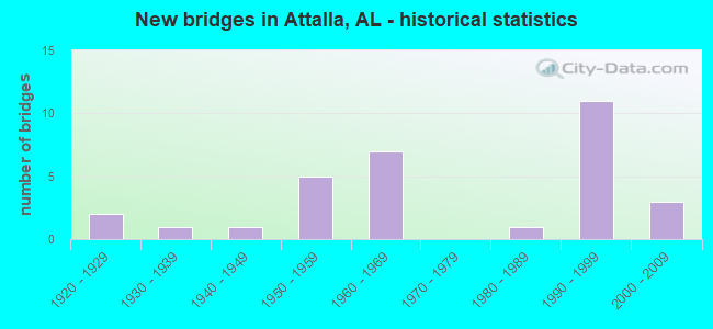
- New bridges - historical statistics
- 21920-1929
- 11930-1939
- 11940-1949
- 51950-1959
- 71960-1969
- 11980-1989
- 111990-1999
- 32000-2009


- Bridge Condition - Deck
- 4.3%Excellent
- 4.3%Very good
- 30.4%Good
- 43.5%Satisfactory
- 17.4%Fair

- Bridge Condition - Superstructure
- 4.3%Excellent
- 34.8%Good
- 21.7%Satisfactory
- 39.1%Fair

- Bridge Condition - Substructure
- 13.0%Very good
- 26.1%Good
- 39.1%Satisfactory
- 21.7%Fair

- Bridge Condition - Channel
- 5.0%Excellent
- 5.0%Very good
- 20.0%Good
- 60.0%Satisfactory
- 10.0%Fair

- Bridge Condition - Culverts
- 50.0%Excellent
- 50.0%Good
Find on map >> Show street view
Structure Number: 1383, Location: .1 MI. SO.I-59 (Lat: 34.019200, Lng: -86.073300), Route carried "on" structure: US 431, Year Built: 1963, Status: Open, Structure Length: 8.29m (27.20ft), Average Daily Traffic: 14,494 (year 2019), Truck Traffic: 11%, Average Future Daily Traffic: 20,992 (year 2039), Design Load: HS 20, Features Intersected: LITTLE WILLS CREEK
Minimum Vertical Clearance: 30+ m (98+ ft), Kilometerpoint: 426.833, Lanes on structure: 4, Base Highway Network: Yes, Owner: State Highway Agency, Approaching Roadway Width: 18.6m (61.0ft), Skew: 20 degrees, Material/Design: Concrete, Design/Construction: Tee Beam, Number Of Spans In Main Unit: 8, Length of Maximum Span: 10.4m (34.1ft), Curb or Sidewalk Widths: Left: 0.0m, Right: 1.2m (3.9ft), Curb-To-Curb Width: 17.7m (58.1ft), Out-to-Out Width: 18.8m (61.7ft)
Condition: Deck: Satisfactory, Superstructure: Satisfactory, Substructure: Satisfactory, Channel: Satisfactory, Operating Rating: 47.5 metric tons, Method Used To Determine Operating Rating: Load Factor (LF), Inventory Rating: 28.5 metric tons, Method Used To Determine Inventory Rating: Load Factor (LF), Structural Evaluation: Equal to present minimum criteria, Deck Geometry: Somewhat better than minimum adequacy, Waterway Adequacy: Equal to present minimum criteria, Approach Roadway Alignment: Equal to present desirable criteria, Length Of Structure Improvement: 9.29m (30.48ft), Designated Inspection Frequency: Every 24 months, Inspection Date: July 2021, Bridge Improvement Cost: $3,885,000, Roadway Improvement Cost: $389,000, Total Project Cost: $4,274,000 ( Estimate for 2022), Deck Structure Type: Concrete Cast-file-Place
Find on map >> Show street view
Structure Number: 2732, Location: 0.3 MILE SOUTH OF HWY 11 (Lat: 33.992783, Lng: -86.123869), Route carried "on" structure: County highway 119, Year Built: 1942, Status: Open, Structure Length: 0.61m (2.00ft), Average Daily Traffic: 1,170 (year 2003), Truck Traffic: 12%, Average Future Daily Traffic: 1,743 (year 2034), Features Intersected: TRIB. TO BIG WILLS CREEK, Facility Carried by Structure: PLEASANT VALLEY RD
Minimum Vertical Clearance: 30+ m (98+ ft), Kilometerpoint: 0.010, Lanes on structure: 2, Owner: County Highway Agency, Approaching Roadway Width: 9.2m (30.2ft), Material/Design: Steel, Design/Construction: Stringer/Multi-beam, Number Of Spans In Main Unit: 1, Length of Maximum Span: 6.1m (20.0ft), Curb or Sidewalk Widths: Left: 0.2m (0.7ft), Right: 0.2m (0.7ft), Curb-To-Curb Width: 11.2m (36.7ft), Out-to-Out Width: 11.7m (38.4ft)
Condition: Deck: Satisfactory, Superstructure: Fair, Substructure: Fair, Channel: Good, Operating Rating: 44.5 metric tons, Method Used To Determine Operating Rating: Load Factor (LF), Inventory Rating: 26.8 metric tons, Method Used To Determine Inventory Rating: Load Factor (LF), Structural Evaluation: Somewhat better than minimum adequacy, Deck Geometry: Equal to present minimum criteria, Waterway Adequacy: Equal to present minimum criteria, Approach Roadway Alignment: Equal to present desirable criteria, Length Of Structure Improvement: 1.22m (4.00ft), Designated Inspection Frequency: Every 24 months, Inspection Date: July 2020, Bridge Improvement Cost: $318,000, Roadway Improvement Cost: $32,000, Total Project Cost: $350,000 ( Estimate for 2022), Deck Structure Type: Concrete Cast-file-Place, Wearing Surface/Protective System: Wearing Surface: Bituminous
Find on map >> Show street view
Structure Number: 5386, Location: US 431 * BIG WILLS CREEK (Lat: 34.033225, Lng: -86.110622), Route carried "on" structure: US 431, Year Built: 1927, Year Reconstructed: 1956, Status: Open, Structure Length: 9.42m (30.91ft), Average Daily Traffic: 11,748 (year 2019), Truck Traffic: 10%, Average Future Daily Traffic: 16,447 (year 2039), Design Load: HS 20, Features Intersected: BIG WILLS CREEK
Minimum Vertical Clearance: 30+ m (98+ ft), Kilometerpoint: 431.465, Lanes on structure: 2, Base Highway Network: Yes, Owner: State Highway Agency, Approaching Roadway Width: 7.3m (24.0ft), Material/Design: Concrete, Design/Construction: Tee Beam, Number Of Spans In Main Unit: 9, Length of Maximum Span: 14.3m (46.9ft), Curb-To-Curb Width: 8.5m (27.9ft), Out-to-Out Width: 9.4m (30.8ft)
Condition: Deck: Satisfactory, Superstructure: Fair, Substructure: Satisfactory, Channel: Satisfactory, Operating Rating: 39.8 metric tons, Method Used To Determine Operating Rating: Load Factor (LF), Inventory Rating: 23.9 metric tons, Method Used To Determine Inventory Rating: Load Factor (LF), Structural Evaluation: Somewhat better than minimum adequacy, Deck Geometry: High priority of corrective action, Waterway Adequacy: Equal to present minimum criteria, Approach Roadway Alignment: Better than present minimum criteria, Length Of Structure Improvement: 10.38m (34.06ft), Designated Inspection Frequency: Every 24 months, Other Special Inspection Frequency: Every 12 months, Inspection Date: July 2021, Other Special Inspection Date: July 2021, Bridge Improvement Cost: $2,134,000, Roadway Improvement Cost: $213,000, Total Project Cost: $2,347,000 ( Estimate for 2022), Deck Structure Type: Concrete Cast-file-Place, Wearing Surface/Protective System: Wearing Surface: Bituminous
Find on map >> Show street view
Structure Number: 5387, Location: .1 MI. SO.US 278 (Lat: 34.035561, Lng: -86.111364), Route carried "on" structure: US 431, Year Built: 1927, Year Reconstructed: 1956, Status: Open, Structure Length: 2.62m (8.60ft), Average Daily Traffic: 11,748 (year 2019), Truck Traffic: 10%, Average Future Daily Traffic: 16,447 (year 2039), Design Load: H 15, Features Intersected: LINE CREEK
Minimum Vertical Clearance: 30+ m (98+ ft), Kilometerpoint: 431.707, Lanes on structure: 2, Base Highway Network: Yes, Owner: State Highway Agency, Approaching Roadway Width: 7.3m (24.0ft), Material/Design: Concrete, Design/Construction: Tee Beam, Number Of Spans In Main Unit: 3, Length of Maximum Span: 8.7m (28.5ft), Curb-To-Curb Width: 8.5m (27.9ft), Out-to-Out Width: 9.5m (31.2ft)
Condition: Deck: Satisfactory, Superstructure: Fair, Substructure: Fair, Channel: Satisfactory, Operating Rating: 39.9 metric tons, Method Used To Determine Operating Rating: Load Factor (LF), Inventory Rating: 23.9 metric tons, Method Used To Determine Inventory Rating: Load Factor (LF), Structural Evaluation: Somewhat better than minimum adequacy, Deck Geometry: High priority of corrective action, Waterway Adequacy: Equal to present minimum criteria, Approach Roadway Alignment: Better than present minimum criteria, Length Of Structure Improvement: 3.53m (11.58ft), Designated Inspection Frequency: Every 24 months, Inspection Date: July 2021, Bridge Improvement Cost: $750,000, Roadway Improvement Cost: $75,000, Total Project Cost: $825,000 ( Estimate for 2022), Deck Structure Type: Concrete Cast-file-Place, Wearing Surface/Protective System: Wearing Surface: Bituminous
Find on map >> Show street view
Structure Number: 5432, Location: US 431 * BIG WILLS CREEK (Lat: 34.033269, Lng: -86.110456), Route carried "on" structure: US 431, Year Built: 1956, Status: Open, Structure Length: 10.73m (35.20ft), Average Daily Traffic: 11,784 (year 2019), Truck Traffic: 10%, Average Future Daily Traffic: 16,447 (year 2039), Design Load: HS 20, Features Intersected: BIG WILLS CREEK
Minimum Vertical Clearance: 30+ m (98+ ft), Kilometerpoint: 431.465, Lanes on structure: 2, Base Highway Network: Yes, Owner: State Highway Agency, Approaching Roadway Width: 7.3m (24.0ft), Material/Design: Concrete, Design/Construction: Tee Beam, Number Of Spans In Main Unit: 1, Number Of Approach Spans: 9, Length of Maximum Span: 14.3m (46.9ft), Curb-To-Curb Width: 8.5m (27.9ft), Out-to-Out Width: 9.4m (30.8ft)
Condition: Deck: Satisfactory, Superstructure: Fair, Substructure: Satisfactory, Channel: Satisfactory, Operating Rating: 47.0 metric tons, Method Used To Determine Operating Rating: Load Factor (LF), Inventory Rating: 28.2 metric tons, Method Used To Determine Inventory Rating: Load Factor (LF), Structural Evaluation: Somewhat better than minimum adequacy, Deck Geometry: High priority of corrective action, Waterway Adequacy: Equal to present minimum criteria, Approach Roadway Alignment: Equal to present minimum criteria, Length Of Structure Improvement: 11.63m (38.16ft), Designated Inspection Frequency: Every 24 months, Other Special Inspection Frequency: Every 12 months, Inspection Date: July 2021, Other Special Inspection Date: July 2021, Bridge Improvement Cost: $2,392,000, Roadway Improvement Cost: $239,000, Total Project Cost: $2,631,000 ( Estimate for 2022), Deck Structure Type: Concrete Cast-file-Place
Find on map >> Show street view
Structure Number: 5433, Location: .1 MI. SO. US 278 (Lat: 34.035539, Lng: -86.111200), Route carried "on" structure: US 431, Year Built: 1956, Status: Open, Structure Length: 2.59m (8.50ft), Average Daily Traffic: 7,693 (year 2019), Truck Traffic: 10%, Average Future Daily Traffic: 10,771 (year 2039), Design Load: HS 20, Features Intersected: LINE CREEK
Minimum Vertical Clearance: 30+ m (98+ ft), Kilometerpoint: 431.707, Lanes on structure: 2, Base Highway Network: Yes, Owner: State Highway Agency, Approaching Roadway Width: 7.3m (24.0ft), Skew: 4 degrees, Material/Design: Concrete, Design/Construction: Tee Beam, Number Of Spans In Main Unit: 3, Length of Maximum Span: 8.8m (28.9ft), Curb-To-Curb Width: 8.5m (27.9ft), Out-to-Out Width: 9.4m (30.8ft)
Condition: Deck: Satisfactory, Superstructure: Satisfactory, Substructure: Fair, Channel: Satisfactory, Operating Rating: 48.7 metric tons, Method Used To Determine Operating Rating: Load Factor (LF), Inventory Rating: 29.2 metric tons, Method Used To Determine Inventory Rating: Load Factor (LF), Structural Evaluation: Somewhat better than minimum adequacy, Deck Geometry: High priority of corrective action, Waterway Adequacy: Equal to present minimum criteria, Approach Roadway Alignment: Better than present minimum criteria, Length Of Structure Improvement: 3.49m (11.45ft), Designated Inspection Frequency: Every 24 months, Inspection Date: July 2021, Bridge Improvement Cost: $718,000, Roadway Improvement Cost: $72,000, Total Project Cost: $790,000 ( Estimate for 2022), Deck Structure Type: Concrete Cast-file-Place
Find on map >> Show street view
Structure Number: 5434, Location: 1 MI NO. US 278 (Lat: 34.046850, Lng: -86.111289), Route carried "on" structure: US 431, Year Built: 1956, Status: Open, Structure Length: 5.18m (16.99ft), Average Daily Traffic: 11,748 (year 2020), Truck Traffic: 10%, Average Future Daily Traffic: 16,447 (year 2040), Design Load: HS 20, Features Intersected: LINE CREEK
Minimum Vertical Clearance: 30+ m (98+ ft), Kilometerpoint: 433.303, Lanes on structure: 2, Base Highway Network: Yes, Owner: State Highway Agency, Approaching Roadway Width: 11.9m (39.0ft), Skew: 4 degrees, Material/Design: Concrete, Design/Construction: Tee Beam, Number Of Spans In Main Unit: 5, Length of Maximum Span: 10.4m (34.1ft), Curb-To-Curb Width: 8.5m (27.9ft), Out-to-Out Width: 10.1m (33.1ft)
Condition: Deck: Satisfactory, Superstructure: Satisfactory, Substructure: Satisfactory, Channel: Fair, Operating Rating: 47.0 metric tons, Method Used To Determine Operating Rating: Load Factor (LF), Inventory Rating: 28.2 metric tons, Method Used To Determine Inventory Rating: Load Factor (LF), Structural Evaluation: Equal to present minimum criteria, Deck Geometry: High priority of corrective action, Waterway Adequacy: Equal to present minimum criteria, Approach Roadway Alignment: Equal to present minimum criteria, Length Of Structure Improvement: 6.20m (20.34ft), Designated Inspection Frequency: Every 24 months, Other Special Inspection Frequency: Every 6 months, Inspection Date: July 2021, Other Special Inspection Date: January 2022, Bridge Improvement Cost: $1,403,000, Roadway Improvement Cost: $140,000, Total Project Cost: $1,543,000 ( Estimate for 2022), Deck Structure Type: Concrete Cast-file-Place
Find on map >> Show street view
Structure Number: 5435, Location: 1 MI. NO .US 278 (Lat: 34.046794, Lng: -86.111122), Route carried "on" structure: US 431, Year Built: 1956, Status: Open, Structure Length: 5.18m (16.99ft), Average Daily Traffic: 11,748 (year 2020), Truck Traffic: 10%, Average Future Daily Traffic: 16,447 (year 2040), Design Load: HS 20, Features Intersected: LINE CREEK
Minimum Vertical Clearance: 30+ m (98+ ft), Kilometerpoint: 433.303, Lanes on structure: 2, Base Highway Network: Yes, Owner: State Highway Agency, Approaching Roadway Width: 7.3m (24.0ft), Skew: 4 degrees, Material/Design: Concrete, Design/Construction: Tee Beam, Number Of Spans In Main Unit: 5, Length of Maximum Span: 10.4m (34.1ft), Curb-To-Curb Width: 8.5m (27.9ft), Out-to-Out Width: 9.4m (30.8ft)
Condition: Deck: Good, Superstructure: Fair, Substructure: Fair, Channel: Fair, Operating Rating: 48.5 metric tons, Method Used To Determine Operating Rating: Load Factor (LF), Inventory Rating: 29.1 metric tons, Method Used To Determine Inventory Rating: Load Factor (LF), Structural Evaluation: Somewhat better than minimum adequacy, Deck Geometry: High priority of corrective action, Waterway Adequacy: Equal to present minimum criteria, Approach Roadway Alignment: Better than present minimum criteria, Length Of Structure Improvement: 6.20m (20.34ft), Designated Inspection Frequency: Every 24 months, Other Special Inspection Frequency: Every 6 months, Inspection Date: July 2021, Other Special Inspection Date: January 2022, Bridge Improvement Cost: $1,276,000, Roadway Improvement Cost: $128,000, Total Project Cost: $1,404,000 ( Estimate for 2022), Deck Structure Type: Concrete Cast-file-Place, Wearing Surface/Protective System: Wearing Surface: Bituminous
Find on map >> Show street view
Structure Number: 7544, Location: 3.1 MI N ST CLAIR CO LN (Lat: 33.968892, Lng: -86.119497), Route carried "on" structure: County highway , Year Built: 1962, Status: Open, Structure Length: 9.45m (31.00ft), Average Daily Traffic: 1,323 (year 2020), Truck Traffic: 3%, Average Future Daily Traffic: 1,852 (year 2040), Design Load: H 20, Features Intersected: I 59, Facility Carried by Structure: PLEASANT VALLEY RD
Minimum Vertical Clearance: 30+ m (98+ ft), Kilometerpoint: 178.629, Lanes on structure: 2, Lanes under structure: 4, Owner: State Highway Agency, Approaching Roadway Width: 7.3m (24.0ft), Skew: 3 degrees, Material/Design: Concrete continuous, Design/Construction: Tee Beam, Number Of Spans In Main Unit: 4, Length of Maximum Span: 26.2m (86.0ft), Curb-To-Curb Width: 7.3m (24.0ft), Out-to-Out Width: 8.2m (26.9ft)
Condition: Deck: Satisfactory, Superstructure: Fair, Substructure: Good, Operating Rating: 49.6 metric tons, Method Used To Determine Operating Rating: Load Factor (LF), Inventory Rating: 29.7 metric tons, Method Used To Determine Inventory Rating: Load Factor (LF), Structural Evaluation: Somewhat better than minimum adequacy, Deck Geometry: Meets minimum limits, Underclear: Equal to present minimum criteria, Approach Roadway Alignment: Equal to present minimum criteria, Length Of Structure Improvement: 10.40m (34.12ft), Designated Inspection Frequency: Every 24 months, Inspection Date: Febuary 2022, Bridge Improvement Cost: $1,854,000, Roadway Improvement Cost: $185,000, Total Project Cost: $2,039,000 ( Estimate for 2022), Deck Structure Type: Concrete Cast-file-Place
Find on map >> Show street view
Structure Number: 7546, Location: I 59 * BIG WILLS CK (Lat: 34.011258, Lng: -86.075514), Route carried "on" structure: Interstate 59, Year Built: 1962, Status: Open, Structure Length: 18.35m (60.20ft), Average Daily Traffic: 14,268 (year 2018), Truck Traffic: 25%, Average Future Daily Traffic: 19,975 (year 2038), Design Load: H 20, Features Intersected: BIG WILLS CREEK
Minimum Vertical Clearance: 30+ m (98+ ft), Kilometerpoint: 293.461, Lanes on structure: 2, Base Highway Network: Yes, Owner: State Highway Agency, Approaching Roadway Width: 13.4m (44.0ft), Material/Design: Steel, Design/Construction: Stringer/Multi-beam, Number Of Spans In Main Unit: 2, Number Of Approach Spans: 13, Length of Maximum Span: 24.4m (80.1ft), Curb-To-Curb Width: 8.6m (28.2ft), Out-to-Out Width: 9.4m (30.8ft)
Condition: Deck: Fair, Superstructure: Fair, Substructure: Satisfactory, Channel: Satisfactory, Operating Rating: 44.6 metric tons, Method Used To Determine Operating Rating: Load Factor (LF), Inventory Rating: 26.7 metric tons, Method Used To Determine Inventory Rating: Load Factor (LF), Structural Evaluation: Somewhat better than minimum adequacy, Deck Geometry: High priority of corrective action, Waterway Adequacy: Equal to present desirable criteria, Approach Roadway Alignment: Better than present minimum criteria, Length Of Structure Improvement: 19.01m (62.37ft), Designated Inspection Frequency: Every 24 months, Underwater Inspection Frequency: Every 24 months, Inspection Date: August 2020, Underwater Inspection Date: May 2020, Bridge Improvement Cost: $3,910,000, Roadway Improvement Cost: $391,000, Total Project Cost: $4,301,000 ( Estimate for 2022), Deck Structure Type: Concrete Cast-file-Place
Find on map >> Show street view
Structure Number: 7766, Location: AL 77 * CLEAR CREEK (Lat: 34.032956, Lng: -86.118911), Route carried "on" structure: State highway 77, Year Built: 1962, Status: Open, Structure Length: 6.22m (20.41ft), Average Daily Traffic: 9,488 (year 2020), Truck Traffic: 13%, Average Future Daily Traffic: 13,283 (year 2040), Design Load: HS 20, Features Intersected: CLEAR CREEK
Minimum Vertical Clearance: 30+ m (98+ ft), Kilometerpoint: 179.133, Lanes on structure: 2, Base Highway Network: Yes, Owner: State Highway Agency, Approaching Roadway Width: 8.5m (27.9ft), Skew: 3 degrees, Material/Design: Concrete, Design/Construction: Tee Beam, Number Of Spans In Main Unit: 6, Length of Maximum Span: 10.4m (34.1ft), Curb or Sidewalk Widths: Left: 0.8m (2.6ft), Right: 0.8m (2.6ft), Curb-To-Curb Width: 8.5m (27.9ft), Out-to-Out Width: 9.4m (30.8ft)
Condition: Deck: Fair, Superstructure: Fair, Substructure: Satisfactory, Channel: Satisfactory, Operating Rating: 47.4 metric tons, Method Used To Determine Operating Rating: Load Factor (LF), Inventory Rating: 28.5 metric tons, Method Used To Determine Inventory Rating: Load Factor (LF), Structural Evaluation: Somewhat better than minimum adequacy, Deck Geometry: Meets minimum limits, Waterway Adequacy: Equal to present minimum criteria, Approach Roadway Alignment: Equal to present desirable criteria, Length Of Structure Improvement: 7.26m (23.82ft), Designated Inspection Frequency: Every 24 months, Inspection Date: October 2021, Bridge Improvement Cost: $1,494,000, Roadway Improvement Cost: $149,000, Total Project Cost: $1,643,000 ( Estimate for 2022), Deck Structure Type: Concrete Cast-file-Place
Find on map >> Show street view
Structure Number: 7856, Location: I 59 * N/S RR (Lat: 34.018333, Lng: -86.073333), Route carried "on" structure: Ramp Interstate 59, Year Built: 1963, Status: Open, Structure Length: 12.86m (42.19ft), Average Daily Traffic: 1,991 (year 2018), Truck Traffic: 35%, Average Future Daily Traffic: 2,787 (year 2038), Design Load: HS 20, Features Intersected: N/S RR, Facility Carried by Structure: RAMP TO US 431
Minimum Vertical Clearance: 30+ m (98+ ft), Kilometerpoint: 294.695, Lanes on structure: 1, Base Highway Network: Yes, Owner: State Highway Agency, Approaching Roadway Width: 7.9m (25.9ft), Skew: 4 degrees, Material/Design: Steel, Design/Construction: Stringer/Multi-beam, Number Of Spans In Main Unit: 1, Number Of Approach Spans: 7, Length of Maximum Span: 21.6m (70.9ft), Curb-To-Curb Width: 6.1m (20.0ft), Out-to-Out Width: 7.0m (23.0ft)
Condition: Deck: Satisfactory, Superstructure: Satisfactory, Substructure: Satisfactory, Channel: Satisfactory, Operating Rating: 37.6 metric tons, Method Used To Determine Operating Rating: Load Factor (LF), Inventory Rating: 22.8 metric tons, Method Used To Determine Inventory Rating: Load Factor (LF), Structural Evaluation: Somewhat better than minimum adequacy, Deck Geometry: Somewhat better than minimum adequacy, Underclear: Superior to present desirable criteria, Waterway Adequacy: Superior to present desirable criteria, Approach Roadway Alignment: Equal to present minimum criteria, Length Of Structure Improvement: 13.69m (44.91ft), Designated Inspection Frequency: Every 24 months, Inspection Date: August 2020, Bridge Improvement Cost: $2,158,000, Roadway Improvement Cost: $216,000, Total Project Cost: $2,374,000 ( Estimate for 2022), Deck Structure Type: Concrete Cast-file-Place
Find on map >> Show street view
Structure Number: 7859, Location: I 59 * N/S RR (Lat: 34.018333, Lng: -86.073333), Route carried "on" structure: Ramp Interstate 59, Year Built: 1963, Status: Open, Structure Length: 15.00m (49.21ft), Average Daily Traffic: 3,024 (year 2018), Truck Traffic: 35%, Average Future Daily Traffic: 4,234 (year 2038), Design Load: H 20, Features Intersected: LITTLE WILLS CK * N/S RR
Minimum Vertical Clearance: 30+ m (98+ ft), Kilometerpoint: 294.695, Lanes on structure: 1, Base Highway Network: Yes, Owner: State Highway Agency, Approaching Roadway Width: 7.9m (25.9ft), Skew: 4 degrees, Material/Design: Steel, Design/Construction: Stringer/Multi-beam, Number Of Spans In Main Unit: 1, Number Of Approach Spans: 9, Length of Maximum Span: 21.6m (70.9ft), Curb-To-Curb Width: 6.1m (20.0ft), Out-to-Out Width: 7.0m (23.0ft)
Condition: Deck: Fair, Superstructure: Fair, Substructure: Satisfactory, Channel: Satisfactory, Operating Rating: 38.5 metric tons, Method Used To Determine Operating Rating: Load Factor (LF), Inventory Rating: 23.2 metric tons, Method Used To Determine Inventory Rating: Load Factor (LF), Structural Evaluation: Somewhat better than minimum adequacy, Deck Geometry: Somewhat better than minimum adequacy, Underclear: Superior to present desirable criteria, Waterway Adequacy: Superior to present desirable criteria, Approach Roadway Alignment: Equal to present minimum criteria, Length Of Structure Improvement: 15.77m (51.74ft), Designated Inspection Frequency: Every 24 months, Inspection Date: August 2020, Bridge Improvement Cost: $2,488,000, Roadway Improvement Cost: $249,000, Total Project Cost: $2,737,000 ( Estimate for 2022), Deck Structure Type: Concrete Cast-file-Place
Find on map >> Show street view
Structure Number: 7903, Location: CLEVELAND AVE (Lat: 34.018333, Lng: -86.073333), Route carried "on" structure: City street , Year Built: 1936, Status: Open, Structure Length: 4.05m (13.29ft), Average Daily Traffic: 9,878 (year 2007), Truck Traffic: 12%, Average Future Daily Traffic: 16,188 (year 2040), Design Load: H 20, Features Intersected: LITTLE WILLS CREEK, Facility Carried by Structure: US 431 SPUR
Minimum Vertical Clearance: 30+ m (98+ ft), Kilometerpoint: 0.000, Lanes on structure: 5, Base Highway Network: Yes, Owner: City or Municipal Highway Agency, Approaching Roadway Width: 18.6m (61.0ft), Material/Design: Concrete, Design/Construction: Tee Beam, Number Of Spans In Main Unit: 5, Length of Maximum Span: 8.2m (26.9ft), Curb or Sidewalk Widths: Left: 0.0m, Right: 1.5m (4.9ft), Curb-To-Curb Width: 19.6m (64.3ft), Out-to-Out Width: 21.7m (71.2ft)
Condition: Deck: Satisfactory, Superstructure: Good, Substructure: Good, Channel: Satisfactory, Operating Rating: 54.2 metric tons, Method Used To Determine Operating Rating: Load Factor (LF), Inventory Rating: 32.5 metric tons, Method Used To Determine Inventory Rating: Load Factor (LF), Structural Evaluation: Better than present minimum criteria, Deck Geometry: Meets minimum limits, Waterway Adequacy: Equal to present minimum criteria, Approach Roadway Alignment: Equal to present desirable criteria, Length Of Structure Improvement: 5.01m (16.44ft), Designated Inspection Frequency: Every 24 months, Inspection Date: Febuary 2021, Bridge Improvement Cost: $2,439,000, Roadway Improvement Cost: $244,000, Total Project Cost: $2,683,000 ( Estimate for 2022), Deck Structure Type: Concrete Cast-file-Place, Wearing Surface/Protective System: Wearing Surface: Bituminous
Find on map >> Show street view
Structure Number: 15465, Location: 0.8 MILES N ATTALLACTY LN (Lat: 34.000000, Lng: -86.110000), Route carried "on" structure: State highway 77, Year Built: 1991, Status: Open, Structure Length: 2.01m (6.59ft), Average Daily Traffic: 16,015 (year 2019), Truck Traffic: 9%, Average Future Daily Traffic: 22,421 (year 2039), Design Load: HS 20, Features Intersected: BRANCH
Minimum Vertical Clearance: 30+ m (98+ ft), Kilometerpoint: 175.031, Lanes on structure: 3, Base Highway Network: Yes, Owner: State Highway Agency, Approaching Roadway Width: 11.0m (36.1ft), Material/Design: Concrete, Design/Construction: Culvert, Number Of Spans In Main Unit: 6, Length of Maximum Span: 3.0m (9.8ft)
Condition: Channel: Satisfactory, Culverts: Good, Operating Rating: 88.9 metric tons, Method Used To Determine Operating Rating: Load Factor (LF), Inventory Rating: 88.9 metric tons, Method Used To Determine Inventory Rating: Load Factor (LF), Structural Evaluation: Better than present minimum criteria, Waterway Adequacy: Somewhat better than minimum adequacy, Approach Roadway Alignment: Equal to present desirable criteria, Length Of Structure Improvement: 2.76m (9.06ft), Designated Inspection Frequency: Every 24 months, Inspection Date: June 2021, Bridge Improvement Cost: $1,243,000, Roadway Improvement Cost: $124,000, Total Project Cost: $1,367,000 ( Estimate for 2022), Wearing Surface/Protective System: Wearing Surface: Bituminous
Find on map >> Show street view
Structure Number: 15509, Location: I 59 * ATN RR/US 431 (Lat: 34.018947, Lng: -86.074594), Route carried "on" structure: Interstate 59, Year Built: 1992, Status: Open, Structure Length: 6.49m (21.29ft), Average Daily Traffic: 14,267 (year 2018), Truck Traffic: 25%, Average Future Daily Traffic: 19,974 (year 2038), Design Load: HS 20, Features Intersected: US 431
Minimum Vertical Clearance: 30+ m (98+ ft), Kilometerpoint: 294.573, Lanes on structure: 2, Lanes under structure: 5, Base Highway Network: Yes, Owner: State Highway Agency, Approaching Roadway Width: 12.2m (40.0ft), Material/Design: Steel, Design/Construction: Stringer/Multi-beam, Number Of Spans In Main Unit: 1, Number Of Approach Spans: 2, Length of Maximum Span: 24.4m (80.1ft), Curb-To-Curb Width: 13.4m (44.0ft), Out-to-Out Width: 14.3m (46.9ft)
Condition: Deck: Very good, Superstructure: Good, Substructure: Satisfactory, Operating Rating: 61.2 metric tons, Method Used To Determine Operating Rating: Load Factor (LF), Inventory Rating: 37.8 metric tons, Method Used To Determine Inventory Rating: Load Factor (LF), Structural Evaluation: Equal to present minimum criteria, Deck Geometry: Equal to present minimum criteria, Underclear: Somewhat better than minimum adequacy, Approach Roadway Alignment: Equal to present desirable criteria, Length Of Structure Improvement: 7.53m (24.70ft), Designated Inspection Frequency: Every 24 months, Inspection Date: June 2020, Bridge Improvement Cost: $2,375,000, Roadway Improvement Cost: $238,000, Total Project Cost: $2,613,000 ( Estimate for 2022), Deck Structure Type: Concrete Cast-file-Place
Find on map >> Show street view
Structure Number: 15763, Location: I-59 * N/S RR (Lat: 34.018333, Lng: -86.073333), Route carried "on" structure: Interstate 59, Year Built: 1993, Status: Open, Structure Length: 13.72m (45.01ft), Average Daily Traffic: 14,268 (year 2018), Truck Traffic: 25%, Average Future Daily Traffic: 19,975 (year 2038), Design Load: HS 20, Features Intersected: LITTLE WILLS CR, N/S RR
Minimum Vertical Clearance: 30+ m (98+ ft), Kilometerpoint: 294.695, Lanes on structure: 2, Base Highway Network: Yes, Owner: State Highway Agency, Approaching Roadway Width: 12.2m (40.0ft), Skew: 4 degrees, Material/Design: Prestressed concrete, Design/Construction: Stringer/Multi-beam, Number Of Spans In Main Unit: 4, Number Of Approach Spans: 4, Length of Maximum Span: 21.0m (68.9ft), Curb-To-Curb Width: 13.4m (44.0ft), Out-to-Out Width: 14.3m (46.9ft)
Condition: Deck: Good, Superstructure: Good, Substructure: Good, Channel: Good, Operating Rating: 44.6 metric tons, Method Used To Determine Operating Rating: Load Factor (LF), Inventory Rating: 26.4 metric tons, Method Used To Determine Inventory Rating: Load Factor (LF), Structural Evaluation: Equal to present minimum criteria, Deck Geometry: Equal to present minimum criteria, Underclear: Equal to present desirable criteria, Waterway Adequacy: Superior to present desirable criteria, Approach Roadway Alignment: Equal to present desirable criteria, Length Of Structure Improvement: 14.52m (47.64ft), Designated Inspection Frequency: Every 24 months, Inspection Date: December 2021, Bridge Improvement Cost: $4,581,000, Roadway Improvement Cost: $458,000, Total Project Cost: $5,039,000 ( Estimate for 2022), Deck Structure Type: Concrete Cast-file-Place
Find on map >> Show street view
Structure Number: 15764, Location: I-59 * N/S RR (Lat: 34.018333, Lng: -86.073333), Route carried "on" structure: Interstate 59, Year Built: 1993, Status: Open, Structure Length: 13.72m (45.01ft), Average Daily Traffic: 26,739 (year 2020), Truck Traffic: 30%, Average Future Daily Traffic: 37,435 (year 2040), Design Load: HS 20, Features Intersected: LITTLE WILLS CK * N/S RR
Minimum Vertical Clearance: 30+ m (98+ ft), Kilometerpoint: 294.695, Lanes on structure: 2, Base Highway Network: Yes, Owner: State Highway Agency, Approaching Roadway Width: 12.2m (40.0ft), Skew: 4 degrees, Material/Design: Prestressed concrete, Design/Construction: Stringer/Multi-beam, Number Of Spans In Main Unit: 4, Number Of Approach Spans: 4, Length of Maximum Span: 21.3m (69.9ft), Curb-To-Curb Width: 13.4m (44.0ft), Out-to-Out Width: 14.3m (46.9ft)
Condition: Deck: Good, Superstructure: Good, Substructure: Good, Channel: Good, Operating Rating: 44.7 metric tons, Method Used To Determine Operating Rating: Load Factor (LF), Inventory Rating: 26.5 metric tons, Method Used To Determine Inventory Rating: Load Factor (LF), Structural Evaluation: Equal to present minimum criteria, Deck Geometry: Equal to present minimum criteria, Underclear: Superior to present desirable criteria, Waterway Adequacy: Superior to present desirable criteria, Approach Roadway Alignment: Equal to present desirable criteria, Length Of Structure Improvement: 14.52m (47.64ft), Designated Inspection Frequency: Every 24 months, Inspection Date: December 2021, Bridge Improvement Cost: $4,581,000, Roadway Improvement Cost: $458,000, Total Project Cost: $5,039,000 ( Estimate for 2022), Deck Structure Type: Concrete Cast-file-Place
Find on map >> Show street view
Structure Number: 15791, Location: ATTALLA (Lat: 34.018942, Lng: -86.074800), Route carried "on" structure: Interstate 59, Year Built: 1993, Status: Open, Structure Length: 6.49m (21.29ft), Average Daily Traffic: 14,267 (year 2018), Truck Traffic: 25%, Average Future Daily Traffic: 19,974 (year 2038), Design Load: HS 20, Features Intersected: US 431 * ATN RR
Minimum Vertical Clearance: 30+ m (98+ ft), Kilometerpoint: 294.573, Lanes on structure: 2, Lanes under structure: 4, Owner: State Highway Agency, Approaching Roadway Width: 12.8m (42.0ft), Material/Design: Steel, Design/Construction: Stringer/Multi-beam, Number Of Spans In Main Unit: 1, Number Of Approach Spans: 2, Length of Maximum Span: 24.4m (80.1ft), Curb-To-Curb Width: 13.3m (43.6ft), Out-to-Out Width: 14.3m (46.9ft)
Condition: Deck: Good, Superstructure: Good, Substructure: Good, Operating Rating: 61.2 metric tons, Method Used To Determine Operating Rating: Load Factor (LF), Inventory Rating: 37.8 metric tons, Method Used To Determine Inventory Rating: Load Factor (LF), Structural Evaluation: Better than present minimum criteria, Deck Geometry: Superior to present desirable criteria, Underclear: Somewhat better than minimum adequacy, Approach Roadway Alignment: Equal to present desirable criteria, Length Of Structure Improvement: 7.53m (24.70ft), Designated Inspection Frequency: Every 24 months, Inspection Date: June 2020, Bridge Improvement Cost: $2,375,000, Roadway Improvement Cost: $238,000, Total Project Cost: $2,613,000 ( Estimate for 2022), Deck Structure Type: Concrete Cast-file-Place
Find on map >> Show street view
Structure Number: 15891, Location: I-59 * CLEVELAND AVE. (Lat: 34.018108, Lng: -86.074469), Route carried "on" structure: Interstate 59, Year Built: 1994, Status: Open, Structure Length: 6.09m (19.98ft), Average Daily Traffic: 14,268 (year 2018), Truck Traffic: 25%, Average Future Daily Traffic: 19,975 (year 2038), Design Load: HS 20, Features Intersected: CLEVELAND AVE.
Minimum Vertical Clearance: 30+ m (98+ ft), Kilometerpoint: 294.478, Lanes on structure: 2, Lanes under structure: 4, Base Highway Network: Yes, Owner: State Highway Agency, Approaching Roadway Width: 13.4m (44.0ft), Material/Design: Prestressed concrete, Design/Construction: Stringer/Multi-beam, Number Of Spans In Main Unit: 3, Length of Maximum Span: 30.4m (99.7ft), Curb-To-Curb Width: 13.4m (44.0ft), Out-to-Out Width: 14.3m (46.9ft)
Condition: Deck: Good, Superstructure: Good, Substructure: Very good, Operating Rating: 60.4 metric tons, Method Used To Determine Operating Rating: Load Factor (LF), Inventory Rating: 39.2 metric tons, Method Used To Determine Inventory Rating: Load Factor (LF), Structural Evaluation: Better than present minimum criteria, Deck Geometry: Superior to present desirable criteria, Underclear: Better than present minimum criteria, Approach Roadway Alignment: Equal to present desirable criteria, Length Of Structure Improvement: 7.13m (23.39ft), Designated Inspection Frequency: Every 24 months, Inspection Date: August 2020, Bridge Improvement Cost: $2,250,000, Roadway Improvement Cost: $225,000, Total Project Cost: $2,475,000 ( Estimate for 2022), Deck Structure Type: Concrete Cast-file-Place
Find on map >> Show street view
Structure Number: 16015, Location: I 59 OVER CLEVELAND AVE. (Lat: 34.018103, Lng: -86.074700), Route carried "on" structure: Interstate 59, Year Built: 1994, Status: Open, Structure Length: 6.09m (19.98ft), Average Daily Traffic: 14,268 (year 2018), Truck Traffic: 25%, Average Future Daily Traffic: 19,975 (year 2038), Design Load: HS 20, Features Intersected: CLEVELAND AVE.
Minimum Vertical Clearance: 30+ m (98+ ft), Kilometerpoint: 294.478, Lanes on structure: 2, Lanes under structure: 4, Base Highway Network: Yes, Owner: State Highway Agency, Approaching Roadway Width: 13.4m (44.0ft), Material/Design: Prestressed concrete, Design/Construction: Stringer/Multi-beam, Number Of Spans In Main Unit: 3, Length of Maximum Span: 30.4m (99.7ft), Curb-To-Curb Width: 13.4m (44.0ft), Out-to-Out Width: 14.3m (46.9ft)
Condition: Deck: Good, Superstructure: Good, Substructure: Very good, Operating Rating: 60.4 metric tons, Method Used To Determine Operating Rating: Load Factor (LF), Inventory Rating: 39.2 metric tons, Method Used To Determine Inventory Rating: Load Factor (LF), Structural Evaluation: Better than present minimum criteria, Deck Geometry: Superior to present desirable criteria, Underclear: Somewhat better than minimum adequacy, Approach Roadway Alignment: Equal to present desirable criteria, Length Of Structure Improvement: 7.13m (23.39ft), Designated Inspection Frequency: Every 24 months, Inspection Date: August 2020, Bridge Improvement Cost: $2,250,000, Roadway Improvement Cost: $225,000, Total Project Cost: $2,475,000 ( Estimate for 2022), Deck Structure Type: Concrete Cast-file-Place
Find on map >> Show street view
Structure Number: 17892, Location: US 11 @ ATTALLA (Lat: 34.006003, Lng: -86.111139), Route carried "on" structure: US 11, Year Built: 2000, Status: Open, Structure Length: 12.86m (42.19ft), Average Daily Traffic: 6,037 (year 2018), Truck Traffic: 4%, Average Future Daily Traffic: 8,452 (year 2038), Design Load: HS 20, Features Intersected: BIG WILLS CREEK
Minimum Vertical Clearance: 30+ m (98+ ft), Kilometerpoint: 306.762, Lanes on structure: 5, Owner: State Highway Agency, Approaching Roadway Width: 23.4m (76.8ft), Material/Design: Prestressed concrete, Design/Construction: Stringer/Multi-beam, Number Of Spans In Main Unit: 10, Length of Maximum Span: 16.8m (55.1ft), Curb or Sidewalk Widths: Left: 0.0m, Right: 2.9m (9.5ft), Curb-To-Curb Width: 19.5m (64.0ft), Out-to-Out Width: 23.4m (76.8ft)
Condition: Deck: Good, Superstructure: Good, Substructure: Good, Channel: Good, Operating Rating: 67.1 metric tons, Method Used To Determine Operating Rating: Load Factor (LF), Inventory Rating: 40.2 metric tons, Method Used To Determine Inventory Rating: Load Factor (LF), Structural Evaluation: Better than present minimum criteria, Deck Geometry: Meets minimum limits, Waterway Adequacy: Better than present minimum criteria, Approach Roadway Alignment: Equal to present desirable criteria, Length Of Structure Improvement: 13.69m (44.91ft), Designated Inspection Frequency: Every 24 months, Inspection Date: June 2020, Bridge Improvement Cost: $7,134,000, Roadway Improvement Cost: $713,000, Total Project Cost: $7,847,000 ( Estimate for 2022), Deck Structure Type: Concrete Cast-file-Place
Find on map >> Show street view
Structure Number: 18837, Location: @ MILLERS HOLLOW ROAD (Lat: 34.001667, Lng: -86.135000), Route carried "on" structure: County highway 110, Year Built: 2007, Status: Open, Structure Length: 0.81m (2.66ft), Average Daily Traffic: 585 (year 2007), Truck Traffic: 4%, Average Future Daily Traffic: 837 (year 2034), Design Load: HS 20, Features Intersected: MILLER CREEK, Facility Carried by Structure: CLANTON ST.
Minimum Vertical Clearance: 30+ m (98+ ft), Kilometerpoint: 0.010, Lanes on structure: 2, Owner: County Highway Agency, Approaching Roadway Width: 9.8m (32.2ft), Skew: 1 degrees, Material/Design: Concrete, Design/Construction: Culvert, Number Of Spans In Main Unit: 2, Length of Maximum Span: 3.7m (12.1ft)
Condition: Channel: Very good, Culverts: Excellent, Operating Rating: 68.7 metric tons, Method Used To Determine Operating Rating: Load Factor (LF), Inventory Rating: 41.2 metric tons, Method Used To Determine Inventory Rating: Load Factor (LF), Structural Evaluation: Superior to present desirable criteria, Waterway Adequacy: Equal to present desirable criteria, Approach Roadway Alignment: Equal to present minimum criteria, Length Of Structure Improvement: 1.46m (4.79ft), Designated Inspection Frequency: Every 24 months, Inspection Date: July 2020, Bridge Improvement Cost: $355,000, Roadway Improvement Cost: $36,000, Total Project Cost: $391,000 ( Estimate for 2022)
Find on map >> Show street view
Structure Number: 18845, Location: LAKE RHEA RD. (Lat: 34.018750, Lng: -86.113278), Route carried "on" structure: County highway 404, Year Built: 2007, Status: Open, Structure Length: 7.32m (24.02ft), Average Daily Traffic: 700 (year 2006), Truck Traffic: 5%, Average Future Daily Traffic: 750 (year 2032), Design Load: HS 20, Features Intersected: BIG WILLS CREEK, Facility Carried by Structure: LAKE RHEA RD.
Minimum Vertical Clearance: 30+ m (98+ ft), Kilometerpoint: 0.010, Lanes on structure: 2, Owner: City or Municipal Highway Agency, Approaching Roadway Width: 11.0m (36.1ft), Material/Design: Prestressed concrete, Design/Construction: Stringer/Multi-beam, Number Of Spans In Main Unit: 1, Number Of Approach Spans: 2, Length of Maximum Span: 24.4m (80.1ft), Curb-To-Curb Width: 8.2m (26.9ft), Out-to-Out Width: 8.2m (26.9ft)
Condition: Deck: Excellent, Superstructure: Excellent, Substructure: Very good, Channel: Excellent, Operating Rating: 78.4 metric tons, Method Used To Determine Operating Rating: Load Factor (LF), Inventory Rating: 47.2 metric tons, Method Used To Determine Inventory Rating: Load Factor (LF), Structural Evaluation: Equal to present desirable criteria, Waterway Adequacy: Superior to present desirable criteria, Approach Roadway Alignment: Superior to present desirable criteria, Length Of Structure Improvement: 8.34m (27.36ft), Designated Inspection Frequency: Every 24 months, Inspection Date: Febuary 2021, Bridge Improvement Cost: $1,544,000, Roadway Improvement Cost: $154,000, Total Project Cost: $1,698,000 ( Estimate for 2022), Deck Structure Type: Concrete Cast-file-Place
Find on map >> Show street view
Structure Number: 19857, Location: @ MILLERS HOLLOW RD (Lat: 34.005144, Lng: -86.137072), Route carried "on" structure: County highway , Year Built: 1983, Status: Posted for load, Structure Length: 0.75m (2.46ft), Average Daily Traffic: 50 (year 2003), Average Future Daily Traffic: 51 (year 2034), Features Intersected: MILLER CREEK, Facility Carried by Structure: PONDEROSA RD.
Minimum Vertical Clearance: 30+ m (98+ ft), Kilometerpoint: 0.000, Lanes on structure: 1, Owner: County Highway Agency, Approaching Roadway Width: 5.5m (18.0ft), Material/Design: Wood or Timber, Design/Construction: Stringer/Multi-beam, Number Of Spans In Main Unit: 1, Length of Maximum Span: 6.3m (20.7ft), Curb or Sidewalk Widths: Left: 0.3m (1.0ft), Right: 0.3m (1.0ft), Curb-To-Curb Width: 4.8m (15.7ft), Out-to-Out Width: 5.3m (17.4ft)
Condition: Deck: Fair, Superstructure: Satisfactory, Substructure: Fair, Channel: Satisfactory, Operating Rating: 24.4 metric tons, Method Used To Determine Operating Rating: Allowable Stress (AS), Inventory Rating: 21.0 metric tons, Method Used To Determine Inventory Rating: Allowable Stress (AS), Structural Evaluation: Somewhat better than minimum adequacy, Deck Geometry: Equal to present desirable criteria, Waterway Adequacy: Better than present minimum criteria, Approach Roadway Alignment: Meets minimum limits, Bridge Posting: Required (Relationship of Operating Rating to Maximum Legal Load: > 39.9% below), Length Of Structure Improvement: 1.39m (4.56ft), Designated Inspection Frequency: Every 24 months, Other Special Inspection Frequency: Every 12 months, Inspection Date: July 2020, Other Special Inspection Date: July 2021, Bridge Improvement Cost: $162,000, Roadway Improvement Cost: $16,000, Total Project Cost: $178,000 ( Estimate for 2022), Deck Structure Type: Wood or Timber, Wearing Surface/Protective System: Wearing Surface: Wood or Timber
Find on map >> Show street view
Structure Number: 5431, Location: ATTALLA UNDERPASS (Lat: 34.021667, Lng: -86.088333), Route carried "under" structure: Other road 431, Year Built: 1956, Structure Length: 0. m, Average Daily Traffic: 20,072 (year 2019), Truck Traffic: 6%, Features Intersected: US 431, Facility Carried by Structure: SOUTHERN RR
Minimum Vertical Clearance: 4.27m (14.01ft), Kilometerpoint: 428.086, Lanes under structure: 4, Material/Design: Steel continuous, Design/Construction: Girder and Floorbeam System, Length of Maximum Span: 16.5m (54.1ft)
Find on map >> Show street view
Structure Number: 7544, Location: 3.1 MI N ST CLAIR CO LN (Lat: 33.968892, Lng: -86.119497), Route carried "under" structure: Interstate 59, Year Built: 1962, Structure Length: 0. m, Average Daily Traffic: 22,715 (year 2020), Truck Traffic: 28%, Features Intersected: I 59, Facility Carried by Structure: PLEASANT VALLEY RD
Minimum Vertical Clearance: 5.30m (17.39ft), Kilometerpoint: 287.400, Lanes on structure: 2, Lanes under structure: 4, Material/Design: Concrete continuous, Design/Construction: Tee Beam, Length of Maximum Span: 26.2m (86.0ft)
Find on map >> Show street view
Structure Number: 15509, Location: I 59 * ATN RR/US 431 (Lat: 34.018947, Lng: -86.074594), Route carried "under" structure: US 431, Year Built: 1992, Structure Length: 0. m, Average Daily Traffic: 15,018 (year 2018), Truck Traffic: 12%, Features Intersected: US 431, Facility Carried by Structure: I 59
Minimum Vertical Clearance: 6.40m (21.00ft), Kilometerpoint: 412.476, Lanes on structure: 2, Lanes under structure: 5, Material/Design: Steel, Design/Construction: Stringer/Multi-beam, Length of Maximum Span: 24.4m (80.1ft)
Find on map >> Show street view
Structure Number: 15791, Location: ATTALLA (Lat: 34.018942, Lng: -86.074800), Route carried "under" structure: US 431, Year Built: 1993, Structure Length: 0. m, Average Daily Traffic: 15,018 (year 2018), Truck Traffic: 12%, Features Intersected: US 431 * ATN RR, Facility Carried by Structure: I-59
Minimum Vertical Clearance: 6.40m (21.00ft), Kilometerpoint: 426.959, Lanes on structure: 2, Lanes under structure: 4, Material/Design: Steel, Design/Construction: Stringer/Multi-beam, Length of Maximum Span: 24.4m (80.1ft)
Find on map >> Show street view
Structure Number: 15891, Location: I-59 * CLEVELAND AVE. (Lat: 34.018108, Lng: -86.074469), Route carried "under" structure: Alternate US , Year Built: 1994, Structure Length: 0. m, Average Daily Traffic: 8,360 (year 2018), Truck Traffic: 23%, Features Intersected: CLEVELAND AVE., Facility Carried by Structure: I-59
Minimum Vertical Clearance: 7.41m (24.31ft), Kilometerpoint: 182.459, Lanes on structure: 2, Lanes under structure: 4, Material/Design: Prestressed concrete, Design/Construction: Stringer/Multi-beam, Length of Maximum Span: 30.4m (99.7ft)
Find on map >> Show street view
Structure Number: 16015, Location: I 59 OVER CLEVELAND AVE. (Lat: 34.018103, Lng: -86.074700), Route carried "under" structure: Alternate City street , Year Built: 1994, Structure Length: 0. m, Average Daily Traffic: 8,360 (year 2018), Truck Traffic: 23%, Features Intersected: CLEVELAND AVE., Facility Carried by Structure: I 59
Minimum Vertical Clearance: 7.41m (24.31ft), Kilometerpoint: 182.459, Lanes on structure: 2, Lanes under structure: 4, Material/Design: Prestressed concrete, Design/Construction: Stringer/Multi-beam, Length of Maximum Span: 30.4m (99.7ft)