Bridge Statistics for Aubrey, Texas (TX)
Condition, Traffic, Stress, Structural Evaluation, Project Costs
- National Bridge Inventory (NBI) Statistics
- 15Number of bridges
- 98ft / 29.6mTotal length
- $203,000Total costs
- 44,862Total average daily traffic
- 3,934Total average daily truck traffic
- 45,467Total future (year 2030) average daily traffic
- National Bridge Inventory (NBI) Registered Bridges for Aubrey
- No street view available for this location
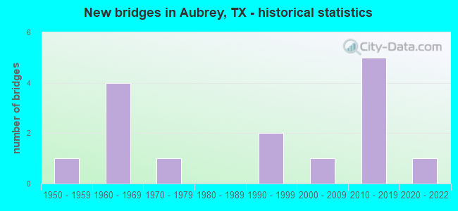
- New bridges - historical statistics
- 11950-1959
- 41960-1969
- 11970-1979
- 21990-1999
- 12000-2009
- 52010-2019
- 12020-2022


- Bridge Condition - Deck
- 20.0%Very good
- 60.0%Good
- 20.0%Satisfactory

- Bridge Condition - Superstructure
- 40.0%Very good
- 20.0%Good
- 40.0%Satisfactory

- Bridge Condition - Substructure
- 60.0%Good
- 40.0%Satisfactory

- Bridge Condition - Channel
- 6.7%Very good
- 53.3%Good
- 26.7%Satisfactory
- 13.3%Fair

- Bridge Condition - Culverts
- 80.0%Good
- 20.0%Satisfactory
Find on map >> Show street view
Structure Number: 180610008105196, Location: 7.50 MI NE OF LP 288 (Lat: 33.304631, Lng: -97.010211), Route carried "on" structure: State highway 428, Year Built: 1999, Status: Open, Structure Length: 1.01m (3.31ft), Average Daily Traffic: 5,969 (year 2020), Average Future Daily Traffic: 7,550 (year 2036), Design Load: HS 20, Features Intersected: AUBREY BRANCH
Minimum Vertical Clearance: 30+ m (98+ ft), Kilometerpoint: 0.002, Lanes on structure: 2, Owner: State Highway Agency, Approaching Roadway Width: 14.6m (47.9ft), Material/Design: Concrete, Design/Construction: Culvert, Number Of Spans In Main Unit: 3, Length of Maximum Span: 2.7m (8.9ft)
Condition: Channel: Fair, Culverts: Satisfactory, Operating Rating: 39.9 metric tons, Method Used To Determine Operating Rating: Load Factor (LF), Inventory Rating: 23.6 metric tons, Method Used To Determine Inventory Rating: Load Factor (LF), Structural Evaluation: Somewhat better than minimum adequacy, Waterway Adequacy: Equal to present minimum criteria, Approach Roadway Alignment: Equal to present minimum criteria, Designated Inspection Frequency: Every 24 months, Inspection Date: September 2021
Find on map >> Show street view
Structure Number: 180610008106061, Location: 0.60 MI S OF FM 428 (Lat: 33.290294, Lng: -96.985789), Route carried "on" structure: US 377, Year Built: 1962, Year Reconstructed: 2021, Status: Open, Structure Length: 0.79m (2.59ft), Average Daily Traffic: 14,313 (year 2020), Truck Traffic: 14%, Average Future Daily Traffic: 14,900 (year 2033), Design Load: HS 20, Features Intersected: RUNNING BRANCH
Minimum Vertical Clearance: 30+ m (98+ ft), Kilometerpoint: 14.940, Lanes on structure: 3, Owner: State Highway Agency, Approaching Roadway Width: 13.4m (44.0ft), Material/Design: Concrete, Design/Construction: Culvert, Number Of Spans In Main Unit: 3, Length of Maximum Span: 2.4m (7.9ft), Out-to-Out Width: 21.5m (70.5ft)
Condition: Channel: Satisfactory, Culverts: Good, Operating Rating: 39.9 metric tons, Method Used To Determine Operating Rating: Load Factor (LF), Inventory Rating: 23.6 metric tons, Method Used To Determine Inventory Rating: Load Factor (LF), Structural Evaluation: Somewhat better than minimum adequacy, Waterway Adequacy: Equal to present minimum criteria, Approach Roadway Alignment: Equal to present desirable criteria, Designated Inspection Frequency: Every 24 months, Inspection Date: September 2021
Find on map >> Show street view
Structure Number: 180610081701003, Location: 3.80 MI E OF US 377 (Lat: 33.297514, Lng: -96.918542), Route carried "on" structure: State highway 428, Year Built: 1954, Status: Open, Structure Length: 3.81m (12.50ft), Average Daily Traffic: 3,557 (year 2020), Truck Traffic: 7%, Average Future Daily Traffic: 1,540 (year 2033), Features Intersected: PECAN CREEK
Minimum Vertical Clearance: 30+ m (98+ ft), Kilometerpoint: 8.748, Lanes on structure: 2, Owner: State Highway Agency, Approaching Roadway Width: 7.3m (24.0ft), Material/Design: Concrete, Design/Construction: Slab, Number Of Spans In Main Unit: 5, Length of Maximum Span: 7.6m (24.9ft), Curb-To-Curb Width: 7.2m (23.6ft), Out-to-Out Width: 7.7m (25.3ft)
Condition: Deck: Satisfactory, Superstructure: Satisfactory, Substructure: Satisfactory, Channel: Satisfactory, Operating Rating: 47.2 metric tons, Method Used To Determine Operating Rating: Load Factor (LF), Inventory Rating: 24.5 metric tons, Method Used To Determine Inventory Rating: Load Factor (LF), Structural Evaluation: Equal to present minimum criteria, Deck Geometry: High priority of replacement, Waterway Adequacy: Better than present minimum criteria, Approach Roadway Alignment: Equal to present minimum criteria, Length Of Structure Improvement: 4.66m (15.29ft), Designated Inspection Frequency: Every 24 months, Inspection Date: August 2021, Bridge Improvement Cost: $162,000, Roadway Improvement Cost: $41,000, Total Project Cost: $203,000, Deck Structure Type: Concrete Cast-file-Place, Wearing Surface/Protective System: Wearing Surface: Bituminous
Find on map >> Show street view
Structure Number: 180610081701004, Location: 1.90 MI E OF US 377 (Lat: 33.299672, Lng: -96.949461), Route carried "on" structure: State highway 428, Year Built: 1966, Year Reconstructed: 2021, Status: Open, Structure Length: 0.88m (2.89ft), Average Daily Traffic: 4,201 (year 2019), Truck Traffic: 7%, Average Future Daily Traffic: 5,650 (year 2033), Design Load: HS 20, Features Intersected: DRAW
Minimum Vertical Clearance: 30+ m (98+ ft), Kilometerpoint: 5.790, Lanes on structure: 2, Owner: State Highway Agency, Approaching Roadway Width: 7.6m (24.9ft), Material/Design: Concrete, Design/Construction: Culvert, Number Of Spans In Main Unit: 3, Length of Maximum Span: 2.7m (8.9ft)
Condition: Channel: Good, Culverts: Good, Operating Rating: 39.9 metric tons, Method Used To Determine Operating Rating: Load Factor (LF), Inventory Rating: 23.6 metric tons, Method Used To Determine Inventory Rating: Load Factor (LF), Structural Evaluation: Equal to present minimum criteria, Waterway Adequacy: Equal to present minimum criteria, Approach Roadway Alignment: Equal to present desirable criteria, Designated Inspection Frequency: Every 24 months, Inspection Date: September 2021, Wearing Surface/Protective System: Wearing Surface: Bituminous
Find on map >> Show street view
Structure Number: 180610081701005, Location: 3.65 MI E OF US 377 (Lat: 33.297289, Lng: -96.920933), Route carried "on" structure: State highway 428, Year Built: 1966, Year Reconstructed: 2021, Status: Open, Structure Length: 0.64m (2.10ft), Average Daily Traffic: 3,557 (year 2020), Truck Traffic: 7%, Average Future Daily Traffic: 1,540 (year 2033), Design Load: HS 20, Features Intersected: DRAW
Minimum Vertical Clearance: 30+ m (98+ ft), Kilometerpoint: 8.579, Lanes on structure: 2, Owner: State Highway Agency, Approaching Roadway Width: 7.3m (24.0ft), Material/Design: Concrete, Design/Construction: Culvert, Number Of Spans In Main Unit: 2, Length of Maximum Span: 3.0m (9.8ft)
Condition: Channel: Satisfactory, Culverts: Good, Operating Rating: 39.9 metric tons, Method Used To Determine Operating Rating: Load Factor (LF), Inventory Rating: 23.6 metric tons, Method Used To Determine Inventory Rating: Load Factor (LF), Structural Evaluation: Equal to present minimum criteria, Waterway Adequacy: Better than present minimum criteria, Approach Roadway Alignment: Equal to present desirable criteria, Designated Inspection Frequency: Every 24 months, Inspection Date: September 2021
Find on map >> Show street view
Structure Number: 180610081701006, Location: 4.60 MI E OF US 377 (Lat: 33.296178, Lng: -96.905164), Route carried "on" structure: State highway 428, Year Built: 1990, Status: Open, Structure Length: 4.60m (15.09ft), Average Daily Traffic: 3,557 (year 2020), Truck Traffic: 7%, Average Future Daily Traffic: 1,540 (year 2033), Design Load: HS 20, Features Intersected: MUSTANG CREEK
Minimum Vertical Clearance: 30+ m (98+ ft), Kilometerpoint: 10.055, Lanes on structure: 2, Owner: State Highway Agency, Approaching Roadway Width: 10.4m (34.1ft), Material/Design: Concrete, Design/Construction: Stringer/Multi-beam, Number Of Spans In Main Unit: 5, Length of Maximum Span: 9.1m (29.9ft), Curb-To-Curb Width: 10.6m (34.8ft), Out-to-Out Width: 11.2m (36.7ft)
Condition: Deck: Good, Superstructure: Good, Substructure: Good, Channel: Satisfactory, Operating Rating: 61.7 metric tons, Method Used To Determine Operating Rating: Load Factor (LF), Inventory Rating: 37.2 metric tons, Method Used To Determine Inventory Rating: Load Factor (LF), Structural Evaluation: Better than present minimum criteria, Deck Geometry: Somewhat better than minimum adequacy, Waterway Adequacy: Better than present minimum criteria, Approach Roadway Alignment: Equal to present minimum criteria, Designated Inspection Frequency: Every 24 months, Inspection Date: August 2021, Deck Structure Type: Concrete Cast-file-Place
Find on map >> Show street view
Structure Number: 180610131501007, Location: 1.60 MI N OF FM 428 W (Lat: 33.318697, Lng: -96.891378), Route carried "on" structure: State highway 1385, Year Built: 2016, Status: Open, Structure Length: 5.03m (16.50ft), Average Daily Traffic: 1,950 (year 2013), Truck Traffic: 5%, Average Future Daily Traffic: 2,730 (year 2033), Design Load: HL 93, Features Intersected: MUSTANG CREEK
Minimum Vertical Clearance: 30+ m (98+ ft), Kilometerpoint: 8.674, Lanes on structure: 2, Owner: State Highway Agency, Approaching Roadway Width: 12.5m (41.0ft), Material/Design: Concrete, Design/Construction: Box Beam or Girders - Multiple, Number Of Spans In Main Unit: 3, Length of Maximum Span: 16.8m (55.1ft), Curb-To-Curb Width: 14.6m (47.9ft), Out-to-Out Width: 15.2m (49.9ft)
Condition: Deck: Good, Superstructure: Satisfactory, Substructure: Satisfactory, Channel: Good, Operating Rating: 54.4 metric tons, Method Used To Determine Operating Rating: Assigned ratings based on Load and Resistance Factor Design (LRFD) reported in metric tons, Inventory Rating: 32.7 metric tons, Method Used To Determine Inventory Rating: Assigned ratings based on Load and Resistance Factor Design (LRFD) reported in metric tons, Structural Evaluation: Equal to present minimum criteria, Deck Geometry: Superior to present desirable criteria, Waterway Adequacy: Superior to present desirable criteria, Approach Roadway Alignment: Equal to present desirable criteria, Designated Inspection Frequency: Every 24 months, Inspection Date: August 2021, Deck Structure Type: Concrete Cast-file-Place
Find on map >> Show street view
Structure Number: 180610297901001, Location: 1.30 MI N OF FM 428 (Lat: 33.318081, Lng: -96.935792), Route carried "on" structure: State highway 2931, Year Built: 1966, Status: Open, Structure Length: 0.98m (3.22ft), Average Daily Traffic: 1,589 (year 2020), Truck Traffic: 14%, Average Future Daily Traffic: 1,470 (year 2033), Design Load: HS 20, Features Intersected: DRAW
Minimum Vertical Clearance: 30+ m (98+ ft), Kilometerpoint: 3.351, Lanes on structure: 2, Owner: State Highway Agency, Approaching Roadway Width: 6.7m (22.0ft), Material/Design: Concrete, Design/Construction: Culvert, Number Of Spans In Main Unit: 3, Length of Maximum Span: 3.0m (9.8ft), Out-to-Out Width: 11.1m (36.4ft)
Condition: Channel: Good, Culverts: Satisfactory, Operating Rating: 44.4 metric tons, Method Used To Determine Operating Rating: No rating analysis performed, Inventory Rating: 32.7 metric tons, Method Used To Determine Inventory Rating: No rating analysis performed, Structural Evaluation: Equal to present minimum criteria, Waterway Adequacy: Better than present minimum criteria, Approach Roadway Alignment: Equal to present desirable criteria, Designated Inspection Frequency: Every 24 months, Inspection Date: October 2021
Find on map >> Show street view
Structure Number: 180610297901002, Location: 6.15 MI NE OF US 380 (Lat: 33.294292, Lng: -96.937167), Route carried "on" structure: State highway 2931, Year Built: 1970, Status: Open, Structure Length: 1.10m (3.61ft), Average Daily Traffic: 5,680 (year 2013), Truck Traffic: 10%, Average Future Daily Traffic: 7,950 (year 2033), Design Load: HS 20, Features Intersected: DRAW
Minimum Vertical Clearance: 30+ m (98+ ft), Kilometerpoint: 5.977, Lanes on structure: 2, Owner: State Highway Agency, Approaching Roadway Width: 7.3m (24.0ft), Skew: 3 degrees, Material/Design: Concrete, Design/Construction: Culvert, Number Of Spans In Main Unit: 3, Length of Maximum Span: 3.0m (9.8ft)
Condition: Channel: Fair, Culverts: Good, Operating Rating: 44.4 metric tons, Method Used To Determine Operating Rating: No rating analysis performed, Inventory Rating: 32.7 metric tons, Method Used To Determine Inventory Rating: No rating analysis performed, Structural Evaluation: Better than present minimum criteria, Waterway Adequacy: Better than present minimum criteria, Approach Roadway Alignment: Equal to present desirable criteria, Designated Inspection Frequency: Every 24 months, Inspection Date: October 2021
Find on map >> Show street view
Structure Number: 180610AA0129001, Location: 0.80 MI W OF FM 1385 (Lat: 33.332469, Lng: -96.914669), Route carried "on" structure: County highway , Year Built: 2012, Status: Open, Structure Length: 5.49m (18.01ft), Average Daily Traffic: 100 (year 2013), Truck Traffic: 3%, Average Future Daily Traffic: 120 (year 2033), Design Load: HL 93, Features Intersected: PECAN CREEK, Facility Carried by Structure: JOE ALLEN RD
Minimum Vertical Clearance: 30+ m (98+ ft), Kilometerpoint: 2.816, Lanes on structure: 2, Owner: County Highway Agency, Approaching Roadway Width: 6.7m (22.0ft), Skew: 1 degrees, Material/Design: Prestressed concrete, Design/Construction: Stringer/Multi-beam, Number Of Spans In Main Unit: 3, Length of Maximum Span: 21.3m (69.9ft), Curb-To-Curb Width: 8.3m (27.2ft), Out-to-Out Width: 9.1m (29.9ft)
Condition: Deck: Good, Superstructure: Very good, Substructure: Good, Channel: Good, Operating Rating: 54.4 metric tons, Method Used To Determine Operating Rating: Assigned ratings based on Load and Resistance Factor Design (LRFD) reported in metric tons, Inventory Rating: 32.7 metric tons, Method Used To Determine Inventory Rating: Assigned ratings based on Load and Resistance Factor Design (LRFD) reported in metric tons, Structural Evaluation: Better than present minimum criteria, Deck Geometry: Equal to present minimum criteria, Waterway Adequacy: Superior to present desirable criteria, Approach Roadway Alignment: Equal to present desirable criteria, Designated Inspection Frequency: Every 24 months, Inspection Date: March 2021, Deck Structure Type: Concrete Precast Panels, Wearing Surface/Protective System: Deck Protection: Epoxy Coated Reinforcing
Find on map >> Show street view
Structure Number: 180610AA0141001, Location: 0.4 MI N OF FM 428 (Lat: 33.309136, Lng: -97.031264), Route carried "on" structure: County highway , Year Built: 2012, Status: Open, Structure Length: 1.22m (4.00ft), Average Daily Traffic: 50 (year 2017), Average Future Daily Traffic: 75 (year 2037), Features Intersected: AUBREY BRANCH CREEK, Facility Carried by Structure: W BLACKJACK RD
Minimum Vertical Clearance: 30+ m (98+ ft), Kilometerpoint: 47.432, Lanes on structure: 2, Owner: County Highway Agency, Approaching Roadway Width: 7.3m (24.0ft), Skew: 3 degrees, Material/Design: Prestressed concrete, Design/Construction: Stringer/Multi-beam, Number Of Spans In Main Unit: 1, Length of Maximum Span: 12.2m (40.0ft), Curb-To-Curb Width: 7.1m (23.3ft), Out-to-Out Width: 7.9m (25.9ft)
Condition: Deck: Very good, Superstructure: Very good, Substructure: Good, Channel: Good, Operating Rating: 32.7 metric tons, Method Used To Determine Operating Rating: Field evaluation and documented engineering judgment, Inventory Rating: 24.5 metric tons, Method Used To Determine Inventory Rating: Field evaluation and documented engineering judgment, Structural Evaluation: Equal to present minimum criteria, Deck Geometry: Somewhat better than minimum adequacy, Waterway Adequacy: Superior to present desirable criteria, Approach Roadway Alignment: Equal to present desirable criteria, Designated Inspection Frequency: Every 24 months, Inspection Date: December 2020, Deck Structure Type: Concrete Cast-file-Place
Find on map >> Show street view
Structure Number: 180610AA0277001, Location: 0.60 MI W OF FM 1385 (Lat: 33.320408, Lng: -96.912453), Route carried "on" structure: County highway , Year Built: 2005, Status: Open, Structure Length: 0.98m (3.22ft), Average Daily Traffic: 52 (year 2012), Average Future Daily Traffic: 80 (year 2030), Design Load: HS 20, Features Intersected: PECAN CREEK, Facility Carried by Structure: MUSTANG RD
Minimum Vertical Clearance: 30+ m (98+ ft), Kilometerpoint: 0.161, Lanes on structure: 2, Owner: County Highway Agency, Approaching Roadway Width: 7.3m (24.0ft), Material/Design: Concrete, Design/Construction: Culvert, Number Of Spans In Main Unit: 3, Length of Maximum Span: 3.0m (9.8ft)
Condition: Channel: Good, Culverts: Good, Operating Rating: 54.4 metric tons, Method Used To Determine Operating Rating: Assigned rating based on Load Factor Design (LFD) reported in metric tons, Inventory Rating: 32.7 metric tons, Method Used To Determine Inventory Rating: Assigned rating based on Load Factor Design (LFD) reported in metric tons, Structural Evaluation: Better than present minimum criteria, Waterway Adequacy: Meets minimum limits, Approach Roadway Alignment: Equal to present minimum criteria, Designated Inspection Frequency: Every 24 months, Inspection Date: December 2020
Find on map >> Show street view
Structure Number: 180610AA0575001, Location: 0.50 MI W OF AUBREY PKWY (Lat: 33.262158, Lng: -96.906914), Route carried "on" structure: City street , Year Built: 2020, Status: Open, Structure Length: 1.62m (5.31ft), Average Daily Traffic: 112 (year 2019), Truck Traffic: 3%, Average Future Daily Traffic: 112 (year 2039), Features Intersected: TRIB LITTLE ELM CREEK, Facility Carried by Structure: BRIDLE PATH PKWY
Minimum Vertical Clearance: 30+ m (98+ ft), Kilometerpoint: 0.805, Lanes on structure: 2, Owner: City or Municipal Highway Agency, Approaching Roadway Width: 11.0m (36.1ft), Material/Design: Concrete, Design/Construction: Culvert, Number Of Spans In Main Unit: 5, Length of Maximum Span: 2.7m (8.9ft), Curb or Sidewalk Widths: Left: 1.2m (3.9ft), Right: 2.4m (7.9ft), Curb-To-Curb Width: 11.0m (36.1ft), Out-to-Out Width: 28.5m (93.5ft)
Condition: Channel: Good, Culverts: Good, Operating Rating: 32.7 metric tons, Method Used To Determine Operating Rating: Field evaluation and documented engineering judgment, Inventory Rating: 24.5 metric tons, Method Used To Determine Inventory Rating: Field evaluation and documented engineering judgment, Structural Evaluation: Equal to present minimum criteria, Deck Geometry: Equal to present desirable criteria, Waterway Adequacy: Better than present minimum criteria, Approach Roadway Alignment: Equal to present desirable criteria, Designated Inspection Frequency: Every 24 months, Inspection Date: October 2020, Deck Structure Type: Concrete Cast-file-Place, Wearing Surface/Protective System: Wearing Surface: Monolithic Concrete
Find on map >> Show street view
Structure Number: 180610AA1970001, Location: 1.0 Mi E of US 377 (Lat: 33.334350, Lng: -96.960611), Route carried "on" structure: County highway , Year Built: 2014, Status: Open, Structure Length: 0.67m (2.20ft), Average Daily Traffic: 75 (year 2014), Average Future Daily Traffic: 85 (year 2034), Design Load: HL 93, Features Intersected: Draw, Facility Carried by Structure: Cole Rd
Minimum Vertical Clearance: 30+ m (98+ ft), Kilometerpoint: 0.000, Lanes on structure: 2, Owner: County Highway Agency, Approaching Roadway Width: 6.1m (20.0ft), Skew: 1 degrees, Material/Design: Concrete, Design/Construction: Culvert, Number Of Spans In Main Unit: 2, Length of Maximum Span: 3.0m (9.8ft), Curb-To-Curb Width: 6.1m (20.0ft), Out-to-Out Width: 9.2m (30.2ft)
Condition: Channel: Very good, Culverts: Good, Operating Rating: 54.4 metric tons, Method Used To Determine Operating Rating: Assigned ratings based on Load and Resistance Factor Design (LRFD) reported in metric tons, Inventory Rating: 32.7 metric tons, Method Used To Determine Inventory Rating: Assigned ratings based on Load and Resistance Factor Design (LRFD) reported in metric tons, Structural Evaluation: Better than present minimum criteria, Deck Geometry: Somewhat better than minimum adequacy, Waterway Adequacy: Better than present minimum criteria, Approach Roadway Alignment: Equal to present desirable criteria, Designated Inspection Frequency: Every 24 months, Inspection Date: November 2021, Deck Structure Type: Concrete Cast-file-Place, Wearing Surface/Protective System: Wearing Surface: Bituminous
Find on map >> Show street view
Structure Number: 180610AA4710001, Location: 0.1 Mi NE of FM 1385 (Lat: 33.319269, Lng: -96.891261), Route carried "on" structure: County highway , Year Built: 2014, Status: Open, Structure Length: 0.73m (2.40ft), Average Daily Traffic: 100 (year 2014), Average Future Daily Traffic: 125 (year 2034), Design Load: HL 93, Features Intersected: Branch of Mustang Creek, Facility Carried by Structure: Lights Ranch Rd
Minimum Vertical Clearance: 30+ m (98+ ft), Kilometerpoint: 0.000, Lanes on structure: 2, Owner: County Highway Agency, Approaching Roadway Width: 6.1m (20.0ft), Material/Design: Concrete, Design/Construction: Culvert, Number Of Spans In Main Unit: 2, Length of Maximum Span: 3.0m (9.8ft), Curb-To-Curb Width: 7.6m (24.9ft), Out-to-Out Width: 9.8m (32.2ft)
Condition: Channel: Good, Culverts: Good, Operating Rating: 54.4 metric tons, Method Used To Determine Operating Rating: Assigned ratings based on Load and Resistance Factor Design (LRFD) reported in metric tons, Inventory Rating: 32.7 metric tons, Method Used To Determine Inventory Rating: Assigned ratings based on Load and Resistance Factor Design (LRFD) reported in metric tons, Structural Evaluation: Better than present minimum criteria, Deck Geometry: Equal to present minimum criteria, Waterway Adequacy: Better than present minimum criteria, Approach Roadway Alignment: Equal to present desirable criteria, Designated Inspection Frequency: Every 24 months, Inspection Date: November 2021, Deck Structure Type: Concrete Cast-file-Place, Wearing Surface/Protective System: Wearing Surface: Bituminous