Bridge Statistics for Austintown, Ohio (OH)
Condition, Traffic, Stress, Structural Evaluation, Project Costs
- National Bridge Inventory (NBI) Statistics
- 40Number of bridges
- 489ft / 149mTotal length
- $605,000Total costs
- 491,258Total average daily traffic
- 66,718Total average daily truck traffic
- National Bridge Inventory (NBI) Registered Bridges for Austintown
- No street view available for this location
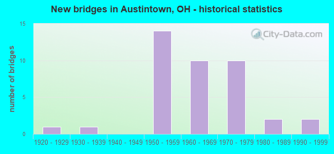
- New bridges - historical statistics
- 11920-1929
- 11930-1939
- 141950-1959
- 101960-1969
- 101970-1979
- 21980-1989
- 21990-1999

- Reconstructed bridges - Historical Statistics
- 11950-1959
- 01960-1969
- 11970-1979
- 61980-1989
- 21990-1999
- 72000-2009


- Bridge Condition - Deck
- 29.2%Very good
- 45.8%Good
- 16.7%Satisfactory
- 8.3%Fair

- Bridge Condition - Superstructure
- 4.2%Excellent
- 29.2%Very good
- 41.7%Good
- 20.8%Satisfactory
- 4.2%Poor

- Bridge Condition - Substructure
- 25.0%Very good
- 50.0%Good
- 20.8%Satisfactory
- 4.2%Fair

- Bridge Condition - Channel
- 70.0%Very good
- 30.0%Satisfactory
Find on map >> Show street view
Structure Number: 5000637, Location: 1.88 MI N OF US 62 (Lat: 41.068839, Lng: -80.752061), Route carried "on" structure: County highway 146, Year Built: 1970, Year Reconstructed: 2008, Status: Open, Structure Length: 8.70m (28.54ft), Average Daily Traffic: 9,022 (year 2015), Truck Traffic: 7%, Average Future Daily Traffic: 48,320 (year 2035), Design Load: H 15, Features Intersected: SR 11
Minimum Vertical Clearance: 30+ m (98+ ft), Kilometerpoint: 8.771, Lanes on structure: 2, Lanes under structure: 4, Owner: State Highway Agency, Approaching Roadway Width: 9.1m (29.9ft), Material/Design: Steel continuous, Design/Construction: Stringer/Multi-beam, Number Of Spans In Main Unit: 4, Length of Maximum Span: 25.0m (82.0ft), Curb or Sidewalk Widths: Left: 1.5m (4.9ft), Right: 1.5m (4.9ft), Curb-To-Curb Width: 9.1m (29.9ft), Out-to-Out Width: 12.8m (42.0ft)
Condition: Deck: Very good, Superstructure: Very good, Substructure: Very good, Operating Rating: 45.4 metric tons, Method Used To Determine Operating Rating: Load and Resistance Factor Rating (LRFR) rating reported by rating factor(RF) method using HL-93 loadings, Inventory Rating: 35.6 metric tons, Method Used To Determine Inventory Rating: Load and Resistance Factor Rating (LRFR) rating reported by rating factor(RF) method using HL-93 loadings, Structural Evaluation: Equal to present desirable criteria, Deck Geometry: Meets minimum limits, Underclear: High priority of corrective action, Approach Roadway Alignment: Equal to present desirable criteria, Designated Inspection Frequency: Every 24 months, Inspection Date: April 2021, Deck Structure Type: Concrete Cast-file-Place, Wearing Surface/Protective System: Wearing Surface: Monolithic Concrete, Deck Protection: Epoxy Coated Reinforcing
Find on map >> Show street view
Structure Number: 5000661, Location: 2.91 MI N OF US 62 (Lat: 41.083689, Lng: -80.751769), Route carried "on" structure: County highway C0162, Year Built: 1970, Year Reconstructed: 2008, Status: Open, Structure Length: 8.86m (29.07ft), Average Daily Traffic: 6,123 (year 2015), Truck Traffic: 5%, Average Future Daily Traffic: 48,320 (year 2035), Design Load: HS 25 or greater, Features Intersected: SR 11, Facility Carried by Structure: NEW ROAD CR 162
Minimum Vertical Clearance: 30+ m (98+ ft), Kilometerpoint: 7.516, Lanes on structure: 2, Lanes under structure: 4, Owner: State Highway Agency, Approaching Roadway Width: 9.1m (29.9ft), Skew: 1 degrees, Material/Design: Steel continuous, Design/Construction: Stringer/Multi-beam, Number Of Spans In Main Unit: 4, Length of Maximum Span: 25.6m (84.0ft), Curb or Sidewalk Widths: Left: 1.5m (4.9ft), Right: 1.5m (4.9ft), Curb-To-Curb Width: 9.1m (29.9ft), Out-to-Out Width: 12.8m (42.0ft)
Condition: Deck: Good, Superstructure: Very good, Substructure: Good, Operating Rating: 42.1 metric tons, Method Used To Determine Operating Rating: Load and Resistance Factor Rating (LRFR) rating reported by rating factor(RF) method using HL-93 loadings, Inventory Rating: 32.4 metric tons, Method Used To Determine Inventory Rating: Load and Resistance Factor Rating (LRFR) rating reported by rating factor(RF) method using HL-93 loadings, Structural Evaluation: Better than present minimum criteria, Deck Geometry: Meets minimum limits, Underclear: High priority of corrective action, Approach Roadway Alignment: Equal to present desirable criteria, Designated Inspection Frequency: Every 24 months, Inspection Date: April 2021, Deck Structure Type: Concrete Cast-file-Place, Wearing Surface/Protective System: Wearing Surface: Monolithic Concrete, Deck Protection: Epoxy Coated Reinforcing
Find on map >> Show street view
Structure Number: 5000696, Location: 3.31 MI N OF US 62 (Lat: 41.089461, Lng: -80.751489), Route carried "on" structure: City street M2280, Year Built: 1968, Status: Open, Structure Length: 8.63m (28.31ft), Average Daily Traffic: 1,949 (year 2015), Truck Traffic: 5%, Average Future Daily Traffic: 48,320 (year 2035), Design Load: H 15, Features Intersected: SR 11, Facility Carried by Structure: OAKCREST DRIVE
Minimum Vertical Clearance: 30+ m (98+ ft), Kilometerpoint: 0.805, Lanes on structure: 2, Lanes under structure: 4, Owner: State Highway Agency, Approaching Roadway Width: 8.5m (27.9ft), Material/Design: Steel continuous, Design/Construction: Stringer/Multi-beam, Number Of Spans In Main Unit: 4, Length of Maximum Span: 25.0m (82.0ft), Curb or Sidewalk Widths: Left: 1.2m (3.9ft), Right: 1.2m (3.9ft), Curb-To-Curb Width: 7.3m (24.0ft), Out-to-Out Width: 10.4m (34.1ft)
Condition: Deck: Very good, Superstructure: Excellent, Substructure: Very good, Operating Rating: 42.1 metric tons, Method Used To Determine Operating Rating: Load Factor (LF) rating reported by rating factor (RF) method using MS18 loading, Inventory Rating: 32.4 metric tons, Method Used To Determine Inventory Rating: Load Factor (LF) rating reported by rating factor (RF) method using MS18 loading, Structural Evaluation: Equal to present desirable criteria, Deck Geometry: Meets minimum limits, Underclear: High priority of corrective action, Approach Roadway Alignment: Equal to present desirable criteria, Designated Inspection Frequency: Every 24 months, Inspection Date: April 2021, Deck Structure Type: Concrete Cast-file-Place, Wearing Surface/Protective System: Wearing Surface: Monolithic Concrete
Find on map >> Show street view
Structure Number: 5000718, Location: 2.07 MI S OF IR 80 (Lat: 41.099581, Lng: -80.752089), Route carried "on" structure: County highway C0018, Year Built: 1970, Year Reconstructed: 2009, Status: Open, Structure Length: 8.60m (28.22ft), Average Daily Traffic: 20,117 (year 2015), Truck Traffic: 10%, Average Future Daily Traffic: 50,738 (year 2035), Design Load: H 20, Features Intersected: CR 18, Facility Carried by Structure: MAHONING AVENUE
Minimum Vertical Clearance: 30+ m (98+ ft), Kilometerpoint: 21.259, Lanes on structure: 4, Lanes under structure: 4, Owner: State Highway Agency, Approaching Roadway Width: 17.1m (56.1ft), Material/Design: Steel continuous, Design/Construction: Stringer/Multi-beam, Number Of Spans In Main Unit: 4, Length of Maximum Span: 25.3m (83.0ft), Curb or Sidewalk Widths: Left: 1.5m (4.9ft), Right: 1.5m (4.9ft), Curb-To-Curb Width: 17.1m (56.1ft), Out-to-Out Width: 19.8m (65.0ft)
Condition: Deck: Very good, Superstructure: Very good, Substructure: Very good, Operating Rating: 42.1 metric tons, Method Used To Determine Operating Rating: Load Factor (LF) rating reported by rating factor (RF) method using MS18 loading, Inventory Rating: 32.4 metric tons, Method Used To Determine Inventory Rating: Load Factor (LF) rating reported by rating factor (RF) method using MS18 loading, Structural Evaluation: Equal to present desirable criteria, Deck Geometry: Somewhat better than minimum adequacy, Underclear: High priority of corrective action, Approach Roadway Alignment: Equal to present desirable criteria, Designated Inspection Frequency: Every 24 months, Inspection Date: April 2021, Deck Structure Type: Concrete Cast-file-Place, Wearing Surface/Protective System: Wearing Surface: Monolithic Concrete, Deck Protection: Epoxy Coated Reinforcing
Find on map >> Show street view
Structure Number: 5000726, Location: 1.46 MI S OF IR 80 (Lat: 41.105539, Lng: -80.755500), Route carried "on" structure: State highway 11, Year Built: 1970, Year Reconstructed: 1993, Status: Open, Structure Length: 4.02m (13.19ft), Average Daily Traffic: 19,149 (year 2015), Truck Traffic: 5%, Average Future Daily Traffic: 26,579 (year 2035), Design Load: HS 20+Mod, Features Intersected: OVER NORQUEST BLVD CR-28
Minimum Vertical Clearance: 30+ m (98+ ft), Kilometerpoint: 23.416, Lanes on structure: 2, Lanes under structure: 2, Base Highway Network: Yes, Owner: State Highway Agency, Approaching Roadway Width: 12.2m (40.0ft), Material/Design: Concrete continuous, Design/Construction: Slab, Number Of Spans In Main Unit: 3, Length of Maximum Span: 15.2m (49.9ft), Curb-To-Curb Width: 12.5m (41.0ft), Out-to-Out Width: 13.4m (44.0ft)
Condition: Deck: Very good, Superstructure: Very good, Substructure: Good, Operating Rating: 68.0 metric tons, Method Used To Determine Operating Rating: Load Factor (LF) rating reported by rating factor (RF) method using MS18 loading, Inventory Rating: 42.1 metric tons, Method Used To Determine Inventory Rating: Load Factor (LF) rating reported by rating factor (RF) method using MS18 loading, Structural Evaluation: Better than present minimum criteria, Deck Geometry: Better than present minimum criteria, Underclear: Somewhat better than minimum adequacy, Approach Roadway Alignment: Equal to present desirable criteria, Designated Inspection Frequency: Every 24 months, Inspection Date: April 2021, Deck Structure Type: Concrete Cast-file-Place, Wearing Surface/Protective System: Wearing Surface: Latex Concrete, Deck Protection: Epoxy Coated Reinforcing
Find on map >> Show street view
Structure Number: 500075, Location: 1.46 MI S OF IR 80 (Lat: 41.105550, Lng: -80.754989), Route carried "on" structure: State highway 11, Year Built: 1970, Year Reconstructed: 1993, Status: Open, Structure Length: 4.02m (13.19ft), Average Daily Traffic: 19,149 (year 2015), Truck Traffic: 5%, Average Future Daily Traffic: 26,579 (year 2035), Design Load: HS 20+Mod, Features Intersected: OVER NORQUEST BLVD CR-28
Minimum Vertical Clearance: 30+ m (98+ ft), Kilometerpoint: 23.416, Lanes on structure: 2, Lanes under structure: 2, Base Highway Network: Yes, Owner: State Highway Agency, Approaching Roadway Width: 12.2m (40.0ft), Material/Design: Concrete continuous, Design/Construction: Slab, Number Of Spans In Main Unit: 3, Length of Maximum Span: 15.2m (49.9ft), Curb-To-Curb Width: 12.5m (41.0ft), Out-to-Out Width: 13.4m (44.0ft)
Condition: Deck: Good, Superstructure: Good, Substructure: Good, Operating Rating: 68.0 metric tons, Method Used To Determine Operating Rating: Load Factor (LF) rating reported by rating factor (RF) method using MS18 loading, Inventory Rating: 42.1 metric tons, Method Used To Determine Inventory Rating: Load Factor (LF) rating reported by rating factor (RF) method using MS18 loading, Structural Evaluation: Better than present minimum criteria, Deck Geometry: Better than present minimum criteria, Underclear: Equal to present minimum criteria, Approach Roadway Alignment: Equal to present desirable criteria, Designated Inspection Frequency: Every 24 months, Inspection Date: April 2021, Deck Structure Type: Concrete Cast-file-Place, Wearing Surface/Protective System: Wearing Surface: Latex Concrete, Deck Protection: Epoxy Coated Reinforcing
Find on map >> Show street view
Structure Number: 5001935, Location: 1.82 MI W OF SR 625 (Lat: 41.059600, Lng: -80.717681), Route carried "on" structure: US 62, Year Built: 1990, Status: Open, Structure Length: 1.13m (3.71ft), Average Daily Traffic: 7,112 (year 2015), Truck Traffic: 10%, Average Future Daily Traffic: 9,871 (year 2035), Design Load: HS 20+Mod, Features Intersected: ANDERSON RUN
Minimum Vertical Clearance: 30+ m (98+ ft), Kilometerpoint: 20.519, Lanes on structure: 2, Owner: State Highway Agency, Approaching Roadway Width: 11.6m (38.1ft), Material/Design: Prestressed concrete, Design/Construction: Box Beam or Girders - Multiple, Number Of Spans In Main Unit: 1, Length of Maximum Span: 10.4m (34.1ft), Curb-To-Curb Width: 10.4m (34.1ft), Out-to-Out Width: 10.4m (34.1ft)
Condition: Deck: Good, Superstructure: Good, Substructure: Very good, Channel: Very good, Operating Rating: 42.1 metric tons, Method Used To Determine Operating Rating: Load Factor (LF) rating reported by rating factor (RF) method using MS18 loading, Inventory Rating: 32.4 metric tons, Method Used To Determine Inventory Rating: Load Factor (LF) rating reported by rating factor (RF) method using MS18 loading, Structural Evaluation: Better than present minimum criteria, Deck Geometry: Meets minimum limits, Waterway Adequacy: Equal to present desirable criteria, Approach Roadway Alignment: Equal to present desirable criteria, Designated Inspection Frequency: Every 24 months, Inspection Date: November 2021, Deck Structure Type: Concrete Cast-file-Place, Wearing Surface/Protective System: Wearing Surface: Bituminous, Membrane: Built-up
Find on map >> Show street view
Structure Number: 5002346, Location: 1.36 MI W OF SR46 (Lat: 41.120031, Lng: -80.793450), Route carried "on" structure: Interstate 80, Year Built: 1969, Year Reconstructed: 2007, Status: Open, Structure Length: 4.37m (14.34ft), Average Daily Traffic: 25,070 (year 2015), Truck Traffic: 26%, Average Future Daily Traffic: 34,797 (year 2035), Design Load: HS 25 or greater, Features Intersected: OVER TURNER RD CR-103
Minimum Vertical Clearance: 30+ m (98+ ft), Kilometerpoint: 3.943, Lanes on structure: 4, Lanes under structure: 2, Base Highway Network: Yes, Owner: State Highway Agency, Approaching Roadway Width: 11.6m (38.1ft), Skew: 1 degrees, Material/Design: Concrete continuous, Design/Construction: Slab, Number Of Spans In Main Unit: 4, Length of Maximum Span: 12.6m (41.3ft), Curb-To-Curb Width: 18.9m (62.0ft), Out-to-Out Width: 19.8m (65.0ft)
Condition: Deck: Good, Superstructure: Good, Substructure: Very good, Operating Rating: 68.0 metric tons, Method Used To Determine Operating Rating: Load and Resistance Factor Rating (LRFR) rating reported by rating factor(RF) method using HL-93 loadings, Inventory Rating: 51.8 metric tons, Method Used To Determine Inventory Rating: Load and Resistance Factor Rating (LRFR) rating reported by rating factor(RF) method using HL-93 loadings, Structural Evaluation: Better than present minimum criteria, Deck Geometry: Meets minimum limits, Underclear: Meets minimum limits, Approach Roadway Alignment: Equal to present desirable criteria, Designated Inspection Frequency: Every 24 months, Inspection Date: July 2021, Deck Structure Type: Concrete Cast-file-Place, Wearing Surface/Protective System: Wearing Surface: Monolithic Concrete, Deck Protection: Epoxy Coated Reinforcing
Find on map >> Show street view
Structure Number: 50024, Location: 0.68 MI W OF SR46 (Lat: 41.123419, Lng: -80.781400), Route carried "on" structure: Interstate 80, Year Built: 1969, Year Reconstructed: 2007, Status: Open, Structure Length: 3.48m (11.42ft), Average Daily Traffic: 25,070 (year 2015), Truck Traffic: 26%, Average Future Daily Traffic: 34,797 (year 2035), Design Load: HS 25 or greater, Features Intersected: OVER OHLTOWN RD CR-105
Minimum Vertical Clearance: 30+ m (98+ ft), Kilometerpoint: 5.021, Lanes on structure: 4, Lanes under structure: 2, Base Highway Network: Yes, Owner: State Highway Agency, Approaching Roadway Width: 12.2m (40.0ft), Skew: 2 degrees, Material/Design: Concrete continuous, Design/Construction: Slab, Number Of Spans In Main Unit: 3, Length of Maximum Span: 13.7m (44.9ft), Curb-To-Curb Width: 18.9m (62.0ft), Out-to-Out Width: 19.8m (65.0ft)
Condition: Deck: Good, Superstructure: Good, Substructure: Good, Operating Rating: 42.1 metric tons, Method Used To Determine Operating Rating: Load Factor (LF) rating reported by rating factor (RF) method using MS18 loading, Inventory Rating: 32.4 metric tons, Method Used To Determine Inventory Rating: Load Factor (LF) rating reported by rating factor (RF) method using MS18 loading, Structural Evaluation: Better than present minimum criteria, Deck Geometry: Meets minimum limits, Underclear: Meets minimum limits, Approach Roadway Alignment: Equal to present desirable criteria, Designated Inspection Frequency: Every 24 months, Inspection Date: July 2021, Deck Structure Type: Concrete Cast-file-Place, Wearing Surface/Protective System: Wearing Surface: Monolithic Concrete, Deck Protection: Epoxy Coated Reinforcing
Find on map >> Show street view
Structure Number: 5006422, Location: 1.23 MI E OF IR 80 (Lat: 41.123461, Lng: -80.727289), Route carried "on" structure: County highway C0184, Year Built: 1967, Status: Open, Structure Length: 10.39m (34.09ft), Average Daily Traffic: 242 (year 2015), Truck Traffic: 5%, Average Future Daily Traffic: 46,513 (year 2035), Design Load: H 20, Features Intersected: IR 680, Facility Carried by Structure: LANTERMAN ROAD
Minimum Vertical Clearance: 30+ m (98+ ft), Kilometerpoint: 1.722, Lanes on structure: 2, Lanes under structure: 4, Owner: State Highway Agency, Approaching Roadway Width: 9.1m (29.9ft), Skew: 3 degrees, Material/Design: Steel continuous, Design/Construction: Stringer/Multi-beam, Number Of Spans In Main Unit: 4, Length of Maximum Span: 30.2m (99.1ft), Curb or Sidewalk Widths: Left: 0.7m (2.3ft), Right: 0.7m (2.3ft), Curb-To-Curb Width: 7.9m (25.9ft), Out-to-Out Width: 10.1m (33.1ft)
Condition: Deck: Fair, Superstructure: Satisfactory, Substructure: Satisfactory, Operating Rating: 38.9 metric tons, Method Used To Determine Operating Rating: Load and Resistance Factor Rating (LRFR) rating reported by rating factor(RF) method using HL-93 loadings, Inventory Rating: 29.2 metric tons, Method Used To Determine Inventory Rating: Load and Resistance Factor Rating (LRFR) rating reported by rating factor(RF) method using HL-93 loadings, Structural Evaluation: Equal to present minimum criteria, Deck Geometry: Somewhat better than minimum adequacy, Underclear: High priority of corrective action, Approach Roadway Alignment: Equal to present desirable criteria, Designated Inspection Frequency: Every 12 months, Inspection Date: May 2021, Deck Structure Type: Concrete Cast-file-Place, Wearing Surface/Protective System: Wearing Surface: Bituminous, Membrane: Preformed Fabric
Find on map >> Show street view
Structure Number: 5029171, Location: 0.9MI EAST OF EXIT 15 (Lat: 41.093411, Lng: -80.824739), Route carried "on" structure: County highway C0091, Year Built: 1954, Year Reconstructed: 2002, Status: Open, Structure Length: 9.05m (29.69ft), Average Daily Traffic: 381 (year 2018), Truck Traffic: 2%, Average Future Daily Traffic: 29,624 (year 2038), Features Intersected: I76 OHIO TPK, Facility Carried by Structure: LIPKEY RD
Minimum Vertical Clearance: 30+ m (98+ ft), Kilometerpoint: 3.589, Lanes on structure: 2, Lanes under structure: 4, Owner: State Toll Authority, Approaching Roadway Width: 7.3m (24.0ft), Skew: 4 degrees, Material/Design: Steel continuous, Design/Construction: Stringer/Multi-beam, Number Of Spans In Main Unit: 2, Number Of Approach Spans: 2, Length of Maximum Span: 27.4m (89.9ft), Curb-To-Curb Width: 7.3m (24.0ft), Out-to-Out Width: 8.2m (26.9ft)
Condition: Deck: Very good, Superstructure: Very good, Substructure: Very good, Operating Rating: 97.2 metric tons, Method Used To Determine Operating Rating: Load Factor (LF) rating reported by rating factor (RF) method using MS18 loading, Inventory Rating: 64.8 metric tons, Method Used To Determine Inventory Rating: Load Factor (LF) rating reported by rating factor (RF) method using MS18 loading, Structural Evaluation: Equal to present desirable criteria, Deck Geometry: Somewhat better than minimum adequacy, Underclear: High priority of corrective action, Approach Roadway Alignment: Equal to present desirable criteria, Designated Inspection Frequency: Every 24 months, Inspection Date: April 2021, Deck Structure Type: Concrete Cast-file-Place, Wearing Surface/Protective System: Wearing Surface: Monolithic Concrete, Deck Protection: Epoxy Coated Reinforcing
Find on map >> Show street view
Structure Number: 5029201, Location: 1.9MI EAST OF EXIT 218 (Lat: 41.084189, Lng: -80.812019), Route carried "on" structure: Interstate 76K, Year Built: 1954, Year Reconstructed: 2006, Status: Open, Structure Length: 9.91m (32.51ft), Average Daily Traffic: 9,975 (year 2013), Truck Traffic: 23%, Average Future Daily Traffic: 13,845 (year 2033), Design Load: HS 25 or greater, Features Intersected: MEANDER RES&RD, Facility Carried by Structure: I76 OH TPK EB
Minimum Vertical Clearance: 30+ m (98+ ft), Kilometerpoint: 3.621, Lanes on structure: 2, Base Highway Network: Yes, Toll: On toll road, Owner: State Toll Authority, Approaching Roadway Width: 11.3m (37.1ft), Material/Design: Steel continuous, Design/Construction: Stringer/Multi-beam, Number Of Spans In Main Unit: 6, Length of Maximum Span: 22.9m (75.1ft), Curb-To-Curb Width: 11.3m (37.1ft), Out-to-Out Width: 12.2m (40.0ft)
Condition: Deck: Very good, Superstructure: Good, Substructure: Good, Channel: Very good, Operating Rating: 71.3 metric tons, Method Used To Determine Operating Rating: Load Factor (LF) rating reported by rating factor (RF) method using MS18 loading, Inventory Rating: 42.1 metric tons, Method Used To Determine Inventory Rating: Load Factor (LF) rating reported by rating factor (RF) method using MS18 loading, Structural Evaluation: Better than present minimum criteria, Deck Geometry: Somewhat better than minimum adequacy, Waterway Adequacy: Equal to present desirable criteria, Approach Roadway Alignment: Equal to present desirable criteria, Designated Inspection Frequency: Every 24 months, Inspection Date: April 2021, Deck Structure Type: Concrete Cast-file-Place, Wearing Surface/Protective System: Wearing Surface: Monolithic Concrete, Deck Protection: Epoxy Coated Reinforcing
Find on map >> Show street view
Structure Number: 5029228, Location: 1.9MI EAST OF EXIT 218 (Lat: 41.084361, Lng: -80.811819), Route carried "on" structure: Interstate 76K, Year Built: 1954, Year Reconstructed: 2007, Status: Open, Structure Length: 9.91m (32.51ft), Average Daily Traffic: 9,975 (year 2013), Truck Traffic: 28%, Average Future Daily Traffic: 13,845 (year 2033), Design Load: HS 25 or greater, Features Intersected: MEANDER RES&RD, Facility Carried by Structure: I76 OH TPK WB
Minimum Vertical Clearance: 30+ m (98+ ft), Kilometerpoint: 3.621, Lanes on structure: 2, Base Highway Network: Yes, Toll: On toll road, Owner: State Toll Authority, Approaching Roadway Width: 11.3m (37.1ft), Material/Design: Steel continuous, Design/Construction: Stringer/Multi-beam, Number Of Spans In Main Unit: 6, Length of Maximum Span: 22.9m (75.1ft), Curb-To-Curb Width: 11.3m (37.1ft), Out-to-Out Width: 12.2m (40.0ft)
Condition: Deck: Very good, Superstructure: Good, Substructure: Good, Channel: Very good, Operating Rating: 71.3 metric tons, Method Used To Determine Operating Rating: Load Factor (LF) rating reported by rating factor (RF) method using MS18 loading, Inventory Rating: 42.1 metric tons, Method Used To Determine Inventory Rating: Load Factor (LF) rating reported by rating factor (RF) method using MS18 loading, Structural Evaluation: Better than present minimum criteria, Deck Geometry: Somewhat better than minimum adequacy, Waterway Adequacy: Equal to present desirable criteria, Approach Roadway Alignment: Equal to present desirable criteria, Designated Inspection Frequency: Every 24 months, Inspection Date: April 2021, Deck Structure Type: Concrete Cast-file-Place, Wearing Surface/Protective System: Wearing Surface: Monolithic Concrete, Deck Protection: Epoxy Coated Reinforcing
Find on map >> Show street view
Structure Number: 502926, Location: 3.3MI EAST OF EXIT 15 (Lat: 41.069981, Lng: -80.791439), Route carried "on" structure: Interstate 76K, Year Built: 1954, Year Reconstructed: 1985, Status: Open, Structure Length: 5.06m (16.60ft), Average Daily Traffic: 8,300 (year 1990), Truck Traffic: 28%, Average Future Daily Traffic: 11,520 (year 2010), Features Intersected: TURNER RD, Facility Carried by Structure: I76 OH TPK EB
Minimum Vertical Clearance: 30+ m (98+ ft), Kilometerpoint: 5.971, Lanes on structure: 2, Lanes under structure: 2, Base Highway Network: Yes, Toll: On toll road, Owner: State Toll Authority, Approaching Roadway Width: 12.8m (42.0ft), Skew: 5 degrees, Material/Design: Steel continuous, Design/Construction: Stringer/Multi-beam, Number Of Spans In Main Unit: 3, Length of Maximum Span: 17.7m (58.1ft), Curb-To-Curb Width: 11.4m (37.4ft), Out-to-Out Width: 12.3m (40.4ft)
Condition: Deck: Good, Superstructure: Good, Substructure: Satisfactory, Operating Rating: 71.3 metric tons, Method Used To Determine Operating Rating: Load Factor (LF) rating reported by rating factor (RF) method using MS18 loading, Inventory Rating: 42.1 metric tons, Method Used To Determine Inventory Rating: Load Factor (LF) rating reported by rating factor (RF) method using MS18 loading, Structural Evaluation: Equal to present minimum criteria, Deck Geometry: Somewhat better than minimum adequacy, Underclear: Somewhat better than minimum adequacy, Approach Roadway Alignment: Equal to present desirable criteria, Designated Inspection Frequency: Every 12 months, Inspection Date: July 2021, Deck Structure Type: Concrete Cast-file-Place, Wearing Surface/Protective System: Wearing Surface: Monolithic Concrete, Deck Protection: Epoxy Coated Reinforcing
Find on map >> Show street view
Structure Number: 5029279, Location: 3.3MI EAST OF EXIT 15 (Lat: 41.070319, Lng: -80.791431), Route carried "on" structure: Interstate 76K, Year Built: 1954, Year Reconstructed: 1985, Status: Open, Structure Length: 4.57m (14.99ft), Average Daily Traffic: 8,200 (year 1990), Truck Traffic: 28%, Average Future Daily Traffic: 11,382 (year 2010), Design Load: HS 20, Features Intersected: TURNER RD, Facility Carried by Structure: I76 OH TPK WB
Minimum Vertical Clearance: 30+ m (98+ ft), Kilometerpoint: 5.971, Lanes on structure: 2, Lanes under structure: 2, Base Highway Network: Yes, Toll: On toll road, Owner: State Toll Authority, Approaching Roadway Width: 12.8m (42.0ft), Skew: 5 degrees, Material/Design: Steel continuous, Design/Construction: Stringer/Multi-beam, Number Of Spans In Main Unit: 3, Length of Maximum Span: 16.8m (55.1ft), Curb-To-Curb Width: 11.4m (37.4ft), Out-to-Out Width: 12.3m (40.4ft)
Condition: Deck: Satisfactory, Superstructure: Satisfactory, Substructure: Satisfactory, Operating Rating: 74.5 metric tons, Method Used To Determine Operating Rating: Load Factor (LF) rating reported by rating factor (RF) method using MS18 loading, Inventory Rating: 45.4 metric tons, Method Used To Determine Inventory Rating: Load Factor (LF) rating reported by rating factor (RF) method using MS18 loading, Structural Evaluation: Equal to present minimum criteria, Deck Geometry: Somewhat better than minimum adequacy, Underclear: Meets minimum limits, Approach Roadway Alignment: Equal to present desirable criteria, Designated Inspection Frequency: Every 12 months, Inspection Date: July 2021, Deck Structure Type: Concrete Cast-file-Place, Wearing Surface/Protective System: Wearing Surface: Monolithic Concrete, Deck Protection: Epoxy Coated Reinforcing
Find on map >> Show street view
Structure Number: 5029295, Location: 3.4MI EAST OF EXIT 15 (Lat: 41.069211, Lng: -80.790619), Route carried "on" structure: Interstate 76K, Year Built: 1954, Year Reconstructed: 1985, Status: Open, Structure Length: 5.46m (17.91ft), Average Daily Traffic: 10,672 (year 2015), Truck Traffic: 28%, Average Future Daily Traffic: 14,813 (year 2035), Design Load: HS 20+Mod, Features Intersected: KIRK RD, Facility Carried by Structure: I76 OH TPK EB
Minimum Vertical Clearance: 12.19m (39.99ft), Kilometerpoint: 6.099, Lanes on structure: 2, Lanes under structure: 2, Base Highway Network: Yes, Toll: On toll road, Owner: State Toll Authority, Approaching Roadway Width: 12.8m (42.0ft), Skew: 3 degrees, Material/Design: Steel continuous, Design/Construction: Stringer/Multi-beam, Number Of Spans In Main Unit: 3, Length of Maximum Span: 18.6m (61.0ft), Curb-To-Curb Width: 11.4m (37.4ft), Out-to-Out Width: 12.3m (40.4ft)
Condition: Deck: Good, Superstructure: Good, Substructure: Good, Operating Rating: 68.0 metric tons, Method Used To Determine Operating Rating: Load Factor (LF) rating reported by rating factor (RF) method using MS18 loading, Inventory Rating: 42.1 metric tons, Method Used To Determine Inventory Rating: Load Factor (LF) rating reported by rating factor (RF) method using MS18 loading, Structural Evaluation: Better than present minimum criteria, Deck Geometry: Somewhat better than minimum adequacy, Underclear: Superior to present desirable criteria, Approach Roadway Alignment: Equal to present desirable criteria, Designated Inspection Frequency: Every 24 months, Inspection Date: March 2021, Deck Structure Type: Concrete Cast-file-Place, Wearing Surface/Protective System: Wearing Surface: Monolithic Concrete, Deck Protection: Epoxy Coated Reinforcing
Find on map >> Show street view
Structure Number: 5029309, Location: 3.4MI EAST OF EXIT 15 (Lat: 41.069200, Lng: -80.790231), Route carried "on" structure: Interstate 76K, Year Built: 1954, Year Reconstructed: 1985, Status: Open, Structure Length: 5.33m (17.49ft), Average Daily Traffic: 8,200 (year 1990), Truck Traffic: 28%, Average Future Daily Traffic: 11,382 (year 2010), Design Load: HS 20+Mod, Features Intersected: KIRK RD, Facility Carried by Structure: I76 OH TPK WB
Minimum Vertical Clearance: 12.19m (39.99ft), Kilometerpoint: 6.099, Lanes on structure: 2, Lanes under structure: 2, Base Highway Network: Yes, Toll: On toll road, Owner: State Toll Authority, Approaching Roadway Width: 12.8m (42.0ft), Skew: 3 degrees, Material/Design: Steel continuous, Design/Construction: Stringer/Multi-beam, Number Of Spans In Main Unit: 3, Length of Maximum Span: 18.6m (61.0ft), Curb-To-Curb Width: 11.4m (37.4ft), Out-to-Out Width: 12.3m (40.4ft)
Condition: Deck: Good, Superstructure: Good, Substructure: Satisfactory, Operating Rating: 81.0 metric tons, Method Used To Determine Operating Rating: Load Factor (LF) rating reported by rating factor (RF) method using MS18 loading, Inventory Rating: 48.6 metric tons, Method Used To Determine Inventory Rating: Load Factor (LF) rating reported by rating factor (RF) method using MS18 loading, Structural Evaluation: Equal to present minimum criteria, Deck Geometry: Somewhat better than minimum adequacy, Underclear: Superior to present desirable criteria, Approach Roadway Alignment: Equal to present desirable criteria, Designated Inspection Frequency: Every 12 months, Inspection Date: March 2021, Deck Structure Type: Concrete Cast-file-Place, Wearing Surface/Protective System: Wearing Surface: Monolithic Concrete, Deck Protection: Epoxy Coated Reinforcing
Find on map >> Show street view
Structure Number: 5030048, Location: 0.5MI.W OF MAHONING AVE (Lat: 41.102450, Lng: -80.716311), Route carried "on" structure: County highway C0018, Year Built: 1925, Year Reconstructed: 1955, Status: Open, Structure Length: 0.82m (2.69ft), Average Daily Traffic: 14,609 (year 2015), Truck Traffic: 10%, Average Future Daily Traffic: 20,277 (year 2035), Design Load: H 15, Features Intersected: BEARS DEN RUN, Facility Carried by Structure: MAHONING AVE.
Minimum Vertical Clearance: 30+ m (98+ ft), Kilometerpoint: 7.998, Lanes on structure: 4, Owner: County Highway Agency, Approaching Roadway Width: 29.9m (98.1ft), Material/Design: Concrete, Design/Construction: Slab, Number Of Spans In Main Unit: 1, Length of Maximum Span: 7.3m (24.0ft), Curb or Sidewalk Widths: Left: 2.3m (7.5ft), Right: 2.3m (7.5ft), Curb-To-Curb Width: 17.3m (56.8ft), Out-to-Out Width: 21.9m (71.9ft)
Condition: Deck: Satisfactory, Superstructure: Satisfactory, Substructure: Satisfactory, Channel: Satisfactory, Operating Rating: 55.1 metric tons, Method Used To Determine Operating Rating: Load Factor (LF) rating reported by rating factor (RF) method using MS18 loading, Inventory Rating: 32.4 metric tons, Method Used To Determine Inventory Rating: Load Factor (LF) rating reported by rating factor (RF) method using MS18 loading, Structural Evaluation: Equal to present minimum criteria, Deck Geometry: Somewhat better than minimum adequacy, Waterway Adequacy: Equal to present desirable criteria, Approach Roadway Alignment: Equal to present desirable criteria, Length Of Structure Improvement: 0.91m (2.99ft), Designated Inspection Frequency: Every 12 months, Inspection Date: September 2021, Bridge Improvement Cost: $300,000, Roadway Improvement Cost: $100,000, Total Project Cost: $400,000, Deck Structure Type: Concrete Cast-file-Place, Wearing Surface/Protective System: Wearing Surface: Bituminous
Find on map >> Show street view
Structure Number: 5030129, Location: 0.3MI.N OF RACCOON RD. (Lat: 41.120850, Lng: -80.733731), Route carried "on" structure: County highway 119, Year Built: 1931, Status: Open, Structure Length: 0.91m (2.99ft), Average Daily Traffic: 6,047 (year 2015), Truck Traffic: 5%, Average Future Daily Traffic: 8,393 (year 2035), Design Load: HS 15, Features Intersected: FOUR MILE RUN, Facility Carried by Structure: FOUR MILE RUN RD.
Minimum Vertical Clearance: 30+ m (98+ ft), Kilometerpoint: 3.380, Lanes on structure: 2, Owner: County Highway Agency, Approaching Roadway Width: 9.4m (30.8ft), Material/Design: Concrete, Design/Construction: Tee Beam, Number Of Spans In Main Unit: 1, Length of Maximum Span: 8.2m (26.9ft), Curb-To-Curb Width: 7.4m (24.3ft), Out-to-Out Width: 8.4m (27.6ft)
Condition: Deck: Fair, Superstructure: Poor, Substructure: Fair, Channel: Satisfactory, Operating Rating: 81.0 metric tons, Method Used To Determine Operating Rating: Load Factor (LF) rating reported by rating factor (RF) method using MS18 loading, Inventory Rating: 74.5 metric tons, Method Used To Determine Inventory Rating: Load Factor (LF) rating reported by rating factor (RF) method using MS18 loading, Structural Evaluation: Meets minimum limits, Deck Geometry: High priority of replacement, Waterway Adequacy: Equal to present minimum criteria, Approach Roadway Alignment: High priority of replacement, Length Of Structure Improvement: 15.24m (50.00ft), Designated Inspection Frequency: Every 12 months, Inspection Date: September 2021, Bridge Improvement Cost: $145,000, Deck Structure Type: Concrete Cast-file-Place, Wearing Surface/Protective System: Wearing Surface: Bituminous
Find on map >> Show street view
Structure Number: 5030277, Location: 0.9MI.W OF TURNER RD (Lat: 41.097689, Lng: -80.809861), Route carried "on" structure: County highway C0018, Year Built: 1955, Year Reconstructed: 1995, Status: Open, Structure Length: 10.39m (34.09ft), Average Daily Traffic: 6,552 (year 2015), Truck Traffic: 10%, Average Future Daily Traffic: 9,094 (year 2035), Design Load: HS 20+Mod, Features Intersected: MEANDER RESERVOIR, Facility Carried by Structure: MAHONING AVE
Minimum Vertical Clearance: 30+ m (98+ ft), Kilometerpoint: 0.113, Lanes on structure: 2, Owner: County Highway Agency, Approaching Roadway Width: 11.9m (39.0ft), Material/Design: Steel continuous, Design/Construction: Stringer/Multi-beam, Number Of Spans In Main Unit: 5, Length of Maximum Span: 22.6m (74.1ft), Curb-To-Curb Width: 10.4m (34.1ft), Out-to-Out Width: 11.0m (36.1ft)
Condition: Deck: Good, Superstructure: Very good, Substructure: Good, Channel: Very good, Operating Rating: 84.2 metric tons, Method Used To Determine Operating Rating: Load Factor (LF) rating reported by rating factor (RF) method using MS18 loading, Inventory Rating: 51.8 metric tons, Method Used To Determine Inventory Rating: Load Factor (LF) rating reported by rating factor (RF) method using MS18 loading, Structural Evaluation: Better than present minimum criteria, Deck Geometry: Meets minimum limits, Waterway Adequacy: Equal to present desirable criteria, Approach Roadway Alignment: Equal to present desirable criteria, Length Of Structure Improvement: 11.43m (37.50ft), Designated Inspection Frequency: Every 24 months, Underwater Inspection Frequency: Every 60 months, Inspection Date: September 2021, Underwater Inspection Date: May 2017, Bridge Improvement Cost: $129,000, Roadway Improvement Cost: $13,000, Total Project Cost: $160,000, Deck Structure Type: Concrete Cast-file-Place, Wearing Surface/Protective System: Wearing Surface: Monolithic Concrete, Deck Protection: Epoxy Coated Reinforcing
Find on map >> Show street view
Structure Number: 5030307, Location: OVER MEANDER RESERVOIR (Lat: 41.097689, Lng: -80.809861), Route carried "on" structure: County highway C0018, Year Built: 1995, Status: Open, Structure Length: 10.30m (33.79ft), Average Daily Traffic: 6,552 (year 2015), Truck Traffic: 10%, Average Future Daily Traffic: 9,094 (year 2035), Design Load: HS 20+Mod, Features Intersected: MEANDER RESERVOIR, Facility Carried by Structure: MAHONING AVENUE
Minimum Vertical Clearance: 30+ m (98+ ft), Kilometerpoint: 0.161, Lanes on structure: 2, Owner: County Highway Agency, Approaching Roadway Width: 9.1m (29.9ft), Material/Design: Steel continuous, Design/Construction: Stringer/Multi-beam, Number Of Spans In Main Unit: 5, Length of Maximum Span: 22.6m (74.1ft), Curb-To-Curb Width: 10.5m (34.4ft), Out-to-Out Width: 11.1m (36.4ft)
Condition: Deck: Good, Superstructure: Very good, Substructure: Good, Channel: Very good, Operating Rating: 58.3 metric tons, Method Used To Determine Operating Rating: Load Factor (LF) rating reported by rating factor (RF) method using MS18 loading, Inventory Rating: 35.6 metric tons, Method Used To Determine Inventory Rating: Load Factor (LF) rating reported by rating factor (RF) method using MS18 loading, Structural Evaluation: Better than present minimum criteria, Deck Geometry: Somewhat better than minimum adequacy, Waterway Adequacy: Superior to present desirable criteria, Approach Roadway Alignment: Equal to present desirable criteria, Designated Inspection Frequency: Every 24 months, Underwater Inspection Frequency: Every 60 months, Inspection Date: September 2021, Underwater Inspection Date: May 2017, Deck Structure Type: Concrete Cast-file-Place, Wearing Surface/Protective System: Wearing Surface: Monolithic Concrete, Membrane: Epoxy, Deck Protection: Epoxy Coated Reinforcing
Find on map >> Show street view
Structure Number: 5048109, Location: 0.7 miles west of SR 45 (Lat: 41.100261, Lng: -80.822369), Route carried "on" structure: County highway C0018, Year Built: 1955, Status: Open, Structure Length: 0.73m (2.40ft), Average Daily Traffic: 13,104 (year 2015), Truck Traffic: 10%, Average Future Daily Traffic: 18,188 (year 2035), Design Load: HS 20, Features Intersected: A W TBY MEANDER RESEROIR, Facility Carried by Structure: Mahoning Ave.
Minimum Vertical Clearance: 30+ m (98+ ft), Kilometerpoint: 7.033, Lanes on structure: 4, Owner: County Highway Agency, Approaching Roadway Width: 23.5m (77.1ft), Material/Design: Concrete, Design/Construction: Culvert, Number Of Spans In Main Unit: 1, Length of Maximum Span: 6.4m (21.0ft)
Condition: Channel: Satisfactory, Culverts: Fair, Operating Rating: 97.2 metric tons, Method Used To Determine Operating Rating: Load Factor (LF) rating reported by rating factor (RF) method using MS18 loading, Inventory Rating: 68.0 metric tons, Method Used To Determine Inventory Rating: Load Factor (LF) rating reported by rating factor (RF) method using MS18 loading, Structural Evaluation: Somewhat better than minimum adequacy, Waterway Adequacy: Equal to present desirable criteria, Approach Roadway Alignment: Equal to present desirable criteria, Length Of Structure Improvement: 3.05m (10.01ft), Designated Inspection Frequency: Every 12 months, Inspection Date: September 2021, Bridge Improvement Cost: $15,000, Roadway Improvement Cost: $2,000, Total Project Cost: $20,000
Find on map >> Show street view
Structure Number: 5048257, Location: 0.8MI.E OF LIPKEY RD (Lat: 41.069319, Lng: -80.810019), Route carried "on" structure: County highway 146, Year Built: 1986, Status: Open, Structure Length: 2.41m (7.91ft), Average Daily Traffic: 2,318 (year 2015), Truck Traffic: 8%, Average Future Daily Traffic: 3,217 (year 2035), Design Load: HS 20+Mod, Features Intersected: MEANDER RESERVOIR, Facility Carried by Structure: KIRK RD.
Minimum Vertical Clearance: 30+ m (98+ ft), Kilometerpoint: 3.959, Lanes on structure: 2, Owner: County Highway Agency, Approaching Roadway Width: 9.8m (32.2ft), Skew: 1 degrees, Material/Design: Steel, Design/Construction: Stringer/Multi-beam, Number Of Spans In Main Unit: 1, Length of Maximum Span: 22.6m (74.1ft), Curb-To-Curb Width: 9.8m (32.2ft), Out-to-Out Width: 9.8m (32.2ft)
Condition: Deck: Satisfactory, Superstructure: Satisfactory, Substructure: Good, Channel: Very good, Operating Rating: 42.1 metric tons, Method Used To Determine Operating Rating: Load Factor (LF) rating reported by rating factor (RF) method using MS18 loading, Inventory Rating: 29.2 metric tons, Method Used To Determine Inventory Rating: Load Factor (LF) rating reported by rating factor (RF) method using MS18 loading, Structural Evaluation: Equal to present minimum criteria, Deck Geometry: Meets minimum limits, Waterway Adequacy: Better than present minimum criteria, Approach Roadway Alignment: Better than present minimum criteria, Length Of Structure Improvement: 4.57m (14.99ft), Designated Inspection Frequency: Every 12 months, Inspection Date: September 2021, Bridge Improvement Cost: $6,000, Roadway Improvement Cost: $1,000, Total Project Cost: $10,000, Deck Structure Type: Concrete Cast-file-Place, Wearing Surface/Protective System: Wearing Surface: Monolithic Concrete
Find on map >> Show street view
Structure Number: 5048265, Location: 0.1MI.E OF LIPKEY RD. (Lat: 41.062239, Lng: -80.822550), Route carried "on" structure: County highway 118, Year Built: 1989, Status: Open, Structure Length: 3.47m (11.38ft), Average Daily Traffic: 222 (year 2015), Truck Traffic: 8%, Average Future Daily Traffic: 308 (year 2035), Design Load: HS 20, Features Intersected: MEANDER CREEK, Facility Carried by Structure: GIBSON RD.
Minimum Vertical Clearance: 30+ m (98+ ft), Kilometerpoint: 0.145, Lanes on structure: 2, Owner: County Highway Agency, Approaching Roadway Width: 6.1m (20.0ft), Material/Design: Prestressed concrete, Design/Construction: Box Beam or Girders - Multiple, Number Of Spans In Main Unit: 3, Length of Maximum Span: 15.2m (49.9ft), Curb-To-Curb Width: 8.5m (27.9ft), Out-to-Out Width: 8.5m (27.9ft)
Condition: Deck: Good, Superstructure: Satisfactory, Substructure: Good, Channel: Very good, Operating Rating: 58.3 metric tons, Method Used To Determine Operating Rating: Load Factor (LF) rating reported by rating factor (RF) method using MS18 loading, Inventory Rating: 35.6 metric tons, Method Used To Determine Inventory Rating: Load Factor (LF) rating reported by rating factor (RF) method using MS18 loading, Structural Evaluation: Equal to present minimum criteria, Deck Geometry: Equal to present minimum criteria, Waterway Adequacy: Equal to present desirable criteria, Approach Roadway Alignment: Equal to present desirable criteria, Length Of Structure Improvement: 9.14m (29.99ft), Designated Inspection Frequency: Every 12 months, Inspection Date: September 2021, Bridge Improvement Cost: $8,000, Roadway Improvement Cost: $1,000, Total Project Cost: $15,000, Deck Structure Type: Concrete Cast-file-Place, Wearing Surface/Protective System: Wearing Surface: Bituminous
Find on map >> Show street view
Structure Number: 7803303, Location: 1.22 MI W OF US 422 (Lat: 41.141681, Lng: -80.720269), Route carried "on" structure: County highway C0064, Year Built: 1967, Year Reconstructed: 1984, Status: Open, Structure Length: 8.84m (29.00ft), Average Daily Traffic: 3,147 (year 2015), Truck Traffic: 2%, Average Future Daily Traffic: 56,238 (year 2035), Design Load: HS 20+Mod, Features Intersected: IR 80, Facility Carried by Structure: SALT SPRINGS ROAD
Minimum Vertical Clearance: 30+ m (98+ ft), Kilometerpoint: 1.110, Lanes on structure: 4, Lanes under structure: 4, Owner: State Highway Agency, Approaching Roadway Width: 23.2m (76.1ft), Skew: 1 degrees, Material/Design: Steel continuous, Design/Construction: Stringer/Multi-beam, Number Of Spans In Main Unit: 4, Length of Maximum Span: 25.6m (84.0ft), Curb-To-Curb Width: 23.1m (75.8ft), Out-to-Out Width: 24.0m (78.7ft)
Condition: Deck: Satisfactory, Superstructure: Good, Substructure: Good, Operating Rating: 42.1 metric tons, Method Used To Determine Operating Rating: Load Factor (LF) rating reported by rating factor (RF) method using MS18 loading, Inventory Rating: 32.4 metric tons, Method Used To Determine Inventory Rating: Load Factor (LF) rating reported by rating factor (RF) method using MS18 loading, Structural Evaluation: Better than present minimum criteria, Deck Geometry: Superior to present desirable criteria, Underclear: High priority of corrective action, Approach Roadway Alignment: Superior to present desirable criteria, Designated Inspection Frequency: Every 12 months, Inspection Date: November 2021, Deck Structure Type: Concrete Cast-file-Place, Wearing Surface/Protective System: Wearing Surface: Monolithic Concrete, Deck Protection: Epoxy Coated Reinforcing
Find on map >> Show street view
Structure Number: 5000637, Location: 1.88 MI N OF US 62 (Lat: 41.068839, Lng: -80.752061), Route carried "under" structure: State highway 11, Year Built: 1970, Structure Length: 0. m, Average Daily Traffic: 34,813 (year 2015), Truck Traffic: 8%, Features Intersected: UNDER KIRK RD CR-146, Facility Carried by Structure: KIRK ROAD CR 146
Minimum Vertical Clearance: 4.78m (15.68ft), Kilometerpoint: 19.296, Lanes on structure: 2, Lanes under structure: 4, Material/Design: Steel continuous, Design/Construction: Stringer/Multi-beam, Length of Maximum Span: 25.0m (82.0ft)
Find on map >> Show street view
Structure Number: 5000661, Location: 2.91 MI N OF US 62 (Lat: 41.083689, Lng: -80.751769), Route carried "under" structure: State highway 11, Year Built: 1970, Structure Length: 0. m, Average Daily Traffic: 34,813 (year 2015), Truck Traffic: 8%, Features Intersected: UNDER NEW RD CR-162, Facility Carried by Structure: NEW ROAD CR 162
Minimum Vertical Clearance: 4.83m (15.85ft), Kilometerpoint: 20.954, Lanes on structure: 2, Lanes under structure: 4, Material/Design: Steel continuous, Design/Construction: Stringer/Multi-beam, Length of Maximum Span: 25.6m (84.0ft)
Find on map >> Show street view
Structure Number: 5000696, Location: 3.31 MI N OF US 62 (Lat: 41.089461, Lng: -80.751489), Route carried "under" structure: State highway 11, Year Built: 1968, Structure Length: 0. m, Average Daily Traffic: 34,813 (year 2015), Truck Traffic: 8%, Features Intersected: UNDER OAKCREST DRIVE, Facility Carried by Structure: OAKCREST DRIVE
Minimum Vertical Clearance: 4.76m (15.62ft), Kilometerpoint: 21.581, Lanes on structure: 2, Lanes under structure: 4, Material/Design: Steel continuous, Design/Construction: Stringer/Multi-beam, Length of Maximum Span: 25.0m (82.0ft)
Find on map >> Show street view
Structure Number: 5000718, Location: 2.07 MI S OF IR 80 (Lat: 41.099581, Lng: -80.752089), Route carried "under" structure: State highway 11, Year Built: 1970, Structure Length: 0. m, Average Daily Traffic: 36,555 (year 2015), Truck Traffic: 7%, Features Intersected: UNDER MAHONING AVE CR-18, Facility Carried by Structure: MAHONING AVENUE
Minimum Vertical Clearance: 4.47m (14.67ft), Kilometerpoint: 22.708, Lanes on structure: 4, Lanes under structure: 4, Material/Design: Steel continuous, Design/Construction: Stringer/Multi-beam, Length of Maximum Span: 25.3m (83.0ft)
Find on map >> Show street view
Structure Number: 5000726, Location: 1.46 MI S OF IR 80 (Lat: 41.105539, Lng: -80.755500), Route carried "under" structure: County highway 284, Year Built: 1970, Structure Length: 0. m, Average Daily Traffic: 2,227 (year 2015), Truck Traffic: 5%, Features Intersected: SR 11, Facility Carried by Structure: SR 11
Minimum Vertical Clearance: 4.40m (14.44ft), Kilometerpoint: 0.998, Lanes on structure: 2, Lanes under structure: 2, Material/Design: Concrete continuous, Design/Construction: Slab, Length of Maximum Span: 15.2m (49.9ft)
Find on map >> Show street view
Structure Number: 500075, Location: 1.46 MI S OF IR 80 (Lat: 41.105550, Lng: -80.754989), Route carried "under" structure: County highway 284, Year Built: 1970, Structure Length: 0. m, Average Daily Traffic: 2,227 (year 2015), Truck Traffic: 5%, Features Intersected: SR 11, Facility Carried by Structure: SR 11
Minimum Vertical Clearance: 4.42m (14.50ft), Kilometerpoint: 1.030, Lanes on structure: 2, Lanes under structure: 2, Material/Design: Concrete continuous, Design/Construction: Slab, Length of Maximum Span: 15.2m (49.9ft)
Find on map >> Show street view
Structure Number: 5002346, Location: 1.36 MI W OF SR46 (Lat: 41.120031, Lng: -80.793450), Route carried "under" structure: County highway 103, Year Built: 1969, Structure Length: 0. m, Average Daily Traffic: 977 (year 2015), Truck Traffic: 5%, Features Intersected: IR 80, Facility Carried by Structure: E.B. IR80
Minimum Vertical Clearance: 4.42m (14.50ft), Kilometerpoint: 95.756, Lanes on structure: 4, Lanes under structure: 2, Material/Design: Concrete continuous, Design/Construction: Slab, Length of Maximum Span: 12.6m (41.3ft)
Find on map >> Show street view
Structure Number: 50024, Location: 0.68 MI W OF SR46 (Lat: 41.123419, Lng: -80.781400), Route carried "under" structure: County highway 105, Year Built: 1969, Structure Length: 0. m, Average Daily Traffic: 1,674 (year 2015), Truck Traffic: 5%, Features Intersected: IR 80, Facility Carried by Structure: E.B. IR80
Minimum Vertical Clearance: 4.50m (14.76ft), Kilometerpoint: 2.881, Lanes on structure: 4, Lanes under structure: 2, Material/Design: Concrete continuous, Design/Construction: Slab, Length of Maximum Span: 13.7m (44.9ft)
Find on map >> Show street view
Structure Number: 5006422, Location: 1.23 MI E OF IR 80 (Lat: 41.123461, Lng: -80.727289), Route carried "under" structure: Interstate 680, Year Built: 1967, Structure Length: 0. m, Average Daily Traffic: 33,511 (year 2015), Truck Traffic: 8%, Features Intersected: UNDER LANTERMAN RD CR-18, Facility Carried by Structure: LANTERMAN ROAD
Minimum Vertical Clearance: 4.80m (15.75ft), Kilometerpoint: 1.979, Lanes on structure: 2, Lanes under structure: 4, Material/Design: Steel continuous, Design/Construction: Stringer/Multi-beam, Length of Maximum Span: 30.2m (99.1ft)
Find on map >> Show street view
Structure Number: 5029171, Location: 0.9MI EAST OF EXIT 15 (Lat: 41.093411, Lng: -80.824739), Route carried "under" structure: Interstate 76K, Year Built: 1954, Structure Length: 0. m, Average Daily Traffic: 21,343 (year 2015), Truck Traffic: 28%, Features Intersected: LIPKEY RD, Facility Carried by Structure: I76 OH TPK
Minimum Vertical Clearance: 4.50m (14.76ft), Kilometerpoint: 2.108, Lanes on structure: 2, Lanes under structure: 4, Toll: On toll road, Material/Design: Steel continuous, Design/Construction: Stringer/Multi-beam, Length of Maximum Span: 27.4m (89.9ft)
Find on map >> Show street view
Structure Number: 502926, Location: 3.3MI EAST OF EXIT 15 (Lat: 41.069981, Lng: -80.791439), Route carried "under" structure: County highway 103, Year Built: 1954, Structure Length: 0. m, Average Daily Traffic: 600 (year 1972), Features Intersected: I76 OHIO TPK EB, Facility Carried by Structure: TURNER RD
Minimum Vertical Clearance: 5.05m (16.57ft), Kilometerpoint: 3.943, Lanes on structure: 2, Lanes under structure: 2, Material/Design: Steel continuous, Design/Construction: Stringer/Multi-beam, Length of Maximum Span: 17.7m (58.1ft)
Find on map >> Show street view
Structure Number: 5029279, Location: 3.3MI EAST OF EXIT 15 (Lat: 41.070319, Lng: -80.791431), Route carried "under" structure: County highway 103, Year Built: 1954, Structure Length: 0. m, Average Daily Traffic: 600 (year 1972), Truck Traffic: 10%, Features Intersected: I76 OHIO TPK WB, Facility Carried by Structure: TURNER RD
Minimum Vertical Clearance: 4.29m (14.07ft), Kilometerpoint: 3.959, Lanes on structure: 2, Lanes under structure: 2, Material/Design: Steel continuous, Design/Construction: Stringer/Multi-beam, Length of Maximum Span: 16.8m (55.1ft)
Find on map >> Show street view
Structure Number: 5029295, Location: 3.4MI EAST OF EXIT 15 (Lat: 41.069211, Lng: -80.790619), Route carried "under" structure: County highway 146, Year Built: 1954, Structure Length: 0. m, Average Daily Traffic: 5,231 (year 2015), Truck Traffic: 5%, Features Intersected: I76 OHIO TPK EB, Facility Carried by Structure: KIRK RD
Minimum Vertical Clearance: 6.40m (21.00ft), Kilometerpoint: 5.617, Lanes on structure: 2, Lanes under structure: 2, Material/Design: Steel continuous, Design/Construction: Stringer/Multi-beam, Length of Maximum Span: 18.6m (61.0ft)
Find on map >> Show street view
Structure Number: 5029309, Location: 3.4MI EAST OF EXIT 15 (Lat: 41.069200, Lng: -80.790231), Route carried "under" structure: County highway 146, Year Built: 1954, Structure Length: 0. m, Average Daily Traffic: 100 (year 1970), Truck Traffic: 10%, Features Intersected: I76 OHIO TPK WB, Facility Carried by Structure: KIRK RD
Minimum Vertical Clearance: 5.89m (19.32ft), Kilometerpoint: 5.649, Lanes on structure: 2, Lanes under structure: 2, Material/Design: Steel continuous, Design/Construction: Stringer/Multi-beam, Length of Maximum Span: 18.6m (61.0ft)
Find on map >> Show street view
Structure Number: 7803303, Location: 1.22 MI W OF US 422 (Lat: 41.141681, Lng: -80.720269), Route carried "under" structure: Interstate 80, Year Built: 1967, Structure Length: 0. m, Average Daily Traffic: 40,517 (year 2015), Truck Traffic: 20%, Features Intersected: UNDER SALT SPRINGS RD, Facility Carried by Structure: SALT SPRINGS ROAD
Minimum Vertical Clearance: 5.05m (16.57ft), Kilometerpoint: 1.593, Lanes on structure: 4, Lanes under structure: 4, Material/Design: Steel continuous, Design/Construction: Stringer/Multi-beam, Length of Maximum Span: 25.6m (84.0ft)