Bridge Statistics for Aventura, Florida (FL)
Condition, Traffic, Stress, Structural Evaluation, Project Costs
- National Bridge Inventory (NBI) Statistics
- 10Number of bridges
- 525ft / 160mTotal length
- $150,000Total costs
- 127,946Total average daily traffic
- 5,844Total average daily truck traffic
- National Bridge Inventory (NBI) Registered Bridges for Aventura
- No street view available for this location
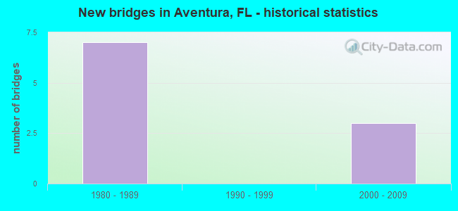
- New bridges - historical statistics
- 71980-1989
- 32000-2009


- Bridge Condition - Deck
- 75.0%Good
- 25.0%Poor

- Bridge Condition - Superstructure
- 75.0%Good
- 25.0%Poor

- Bridge Condition - Substructure
- 75.0%Good
- 25.0%Fair

- Bridge Condition - Channel
- 66.7%Very good
- 33.3%Good
Find on map >> Show street view
Structure Number: 870606, Location: 0.1M W OF A1A (Lat: 25.954269, Lng: -80.126194), Route carried "on" structure: State highway 856, Year Built: 1983, Status: Open, Structure Length: 65.62m (215.29ft), Average Daily Traffic: 16,750 (year 2020), Truck Traffic: 4%, Average Future Daily Traffic: 29,061 (year 2042), Design Load: HL 93, Features Intersected: Intracoastal Waterway
Minimum Vertical Clearance: 5.24m (17.19ft), Kilometerpoint: 1.807, Lanes on structure: 3, Lanes under structure: 6, Owner: State Highway Agency, Approaching Roadway Width: 16.4m (53.8ft), Navigation Control: Yes ( Vertical Clearance: 19.9m (65.3ft), Horizontal Clearance: 27.4m (89.9ft)), Material/Design: Steel continuous, Design/Construction: Stringer/Multi-beam, Number Of Spans In Main Unit: 3, Number Of Approach Spans: 17, Length of Maximum Span: 51.8m (169.9ft), Curb-To-Curb Width: 15.2m (49.9ft), Out-to-Out Width: 16.8m (55.1ft)
Condition: Deck: Good, Superstructure: Good, Substructure: Good, Channel: Very good, Operating Rating: 45.4 metric tons, Method Used To Determine Operating Rating: Load and Resistance Factor (LRFR), Inventory Rating: 28.1 metric tons, Method Used To Determine Inventory Rating: Load and Resistance Factor (LRFR), Structural Evaluation: Better than present minimum criteria, Deck Geometry: Equal to present minimum criteria, Underclear: Meets minimum limits, Waterway Adequacy: Better than present minimum criteria, Approach Roadway Alignment: Equal to present desirable criteria, Length Of Structure Improvement: 4.66m (15.29ft), Designated Inspection Frequency: Every 24 months, Underwater Inspection Frequency: Every 24 months, Inspection Date: Febuary 2020, Underwater Inspection Date: Febuary 2020, Bridge Improvement Cost: $150,000, Total Project Cost: $150,000, Deck Structure Type: Concrete Cast-file-Place, Wearing Surface/Protective System: Wearing Surface: Monolithic Concrete
Find on map >> Show street view
Structure Number: 870607, Location: 0.1M W OF A1A (Lat: 25.954097, Lng: -80.126231), Route carried "on" structure: State highway 856, Year Built: 1983, Status: Open, Structure Length: 78.11m (256.27ft), Average Daily Traffic: 16,750 (year 2020), Truck Traffic: 4%, Average Future Daily Traffic: 29,061 (year 2042), Design Load: HL 93, Features Intersected: Intracoastal Waterway
Minimum Vertical Clearance: 5.99m (19.65ft), Kilometerpoint: 1.807, Lanes on structure: 3, Lanes under structure: 4, Owner: State Highway Agency, Approaching Roadway Width: 16.7m (54.8ft), Navigation Control: Yes ( Vertical Clearance: 19.9m (65.3ft), Horizontal Clearance: 27.4m (89.9ft)), Material/Design: Steel continuous, Design/Construction: Stringer/Multi-beam, Number Of Spans In Main Unit: 3, Number Of Approach Spans: 21, Length of Maximum Span: 51.8m (169.9ft), Curb-To-Curb Width: 15.2m (49.9ft), Out-to-Out Width: 16.8m (55.1ft)
Condition: Deck: Good, Superstructure: Good, Substructure: Good, Channel: Very good, Operating Rating: 46.7 metric tons, Method Used To Determine Operating Rating: Load and Resistance Factor (LRFR), Inventory Rating: 27.4 metric tons, Method Used To Determine Inventory Rating: Load and Resistance Factor (LRFR), Structural Evaluation: Equal to present minimum criteria, Deck Geometry: Equal to present minimum criteria, Underclear: Meets minimum limits, Waterway Adequacy: Better than present minimum criteria, Approach Roadway Alignment: Equal to present desirable criteria, Designated Inspection Frequency: Every 24 months, Underwater Inspection Frequency: Every 24 months, Inspection Date: Febuary 2020, Underwater Inspection Date: Febuary 2020, Deck Structure Type: Concrete Cast-file-Place, Wearing Surface/Protective System: Wearing Surface: Monolithic Concrete
Find on map >> Show street view
Structure Number: 870954, Location: Bisc Blvd & Ives Dairy Rd (Lat: 25.963694, Lng: -80.146944), Route carried "on" structure: State highway 5, Year Built: 2001, Status: Open, Structure Length: 13.93m (45.70ft), Average Daily Traffic: 64,500 (year 2020), Truck Traffic: 6%, Average Future Daily Traffic: 111,908 (year 2042), Design Load: HL 93, Features Intersected: FEC RR & West Dixie Hwy
Minimum Vertical Clearance: 30+ m (98+ ft), Kilometerpoint: 39.517, Lanes on structure: 8, Lanes under structure: 7, Owner: State Highway Agency, Approaching Roadway Width: 33.6m (110.2ft), Skew: 11 degrees, Material/Design: Steel, Design/Construction: Stringer/Multi-beam, Number Of Spans In Main Unit: 5, Length of Maximum Span: 64.0m (210.0ft), Curb-To-Curb Width: 31.2m (102.4ft), Out-to-Out Width: 39.7m (130.2ft)
Condition: Deck: Good, Superstructure: Good, Substructure: Good, Operating Rating: 47.0 metric tons, Method Used To Determine Operating Rating: Load and Resistance Factor (LRFR), Inventory Rating: 36.3 metric tons, Method Used To Determine Inventory Rating: Load and Resistance Factor (LRFR), Structural Evaluation: Better than present minimum criteria, Deck Geometry: Somewhat better than minimum adequacy, Underclear: Somewhat better than minimum adequacy, Approach Roadway Alignment: Equal to present desirable criteria, Designated Inspection Frequency: Every 24 months, Inspection Date: May 2021, Deck Structure Type: Concrete Cast-file-Place, Wearing Surface/Protective System: Wearing Surface: Integral Concrete
Find on map >> Show street view
Structure Number: 8785, Location: 0.1Mi W of Country Club E (Lat: 25.956000, Lng: -80.128583), Route carried "on" structure: City street , Year Built: 1981, Status: Open, Structure Length: 2.36m (7.74ft), Average Daily Traffic: 4,250 (year 2019), Truck Traffic: 1%, Average Future Daily Traffic: 5,100 (year 2041), Design Load: HS 20, Features Intersected: Canal, Facility Carried by Structure: Yacht Club Way
Minimum Vertical Clearance: 30+ m (98+ ft), Kilometerpoint: 0.175, Lanes on structure: 4, Owner: City or Municipal Highway Agency, Approaching Roadway Width: 18.9m (62.0ft), Skew: 20 degrees, Material/Design: Prestressed concrete, Design/Construction: Slab, Number Of Spans In Main Unit: 2, Length of Maximum Span: 10.7m (35.1ft), Curb or Sidewalk Widths: Left: 1.2m (3.9ft), Right: 1.2m (3.9ft), Curb-To-Curb Width: 18.3m (60.0ft), Out-to-Out Width: 24.4m (80.1ft)
Condition: Deck: Poor, Superstructure: Poor, Substructure: Fair, Channel: Good, Operating Rating: 44.7 metric tons, Method Used To Determine Operating Rating: Load and Resistance Factor (LRFR), Inventory Rating: 34.7 metric tons, Method Used To Determine Inventory Rating: Load and Resistance Factor (LRFR), Structural Evaluation: Meets minimum limits, Deck Geometry: Somewhat better than minimum adequacy, Waterway Adequacy: Better than present minimum criteria, Approach Roadway Alignment: Equal to present desirable criteria, Designated Inspection Frequency: Every 24 months, Underwater Inspection Frequency: Every 24 months, Other Special Inspection Frequency: Every 12 months, Inspection Date: March 2020, Underwater Inspection Date: March 2020, Other Special Inspection Date: March 2021, Deck Structure Type: Concrete Precast Panels, Wearing Surface/Protective System: Wearing Surface: Other
Find on map >> Show street view
Structure Number: 870606, Location: 0.1M W OF A1A (Lat: 25.954269, Lng: -80.126194), Route carried "under" structure: City street , Year Built: 1983, Structure Length: 0. m, Average Daily Traffic: 8,523 (year 2004), Truck Traffic: 1%, Features Intersected: Intracoastal Waterway, Facility Carried by Structure: SR856 WB (870607)
Minimum Vertical Clearance: 5.00m (16.40ft), Kilometerpoint: 0.000, Lanes on structure: 3, Lanes under structure: 2, Material/Design: Steel continuous, Design/Construction: Stringer/Multi-beam, Length of Maximum Span: 51.8m (169.9ft)
Find on map >> Show street view
Structure Number: 870606, Location: 0.1M W OF A1A (Lat: 25.954269, Lng: -80.126194), Route carried "under" structure: City street , Year Built: 1983, Structure Length: 0. m, Average Daily Traffic: 100 (year 2004), Features Intersected: Intracoastal Waterway, Facility Carried by Structure: SR856 WB (870607)
Minimum Vertical Clearance: 12.19m (39.99ft), Kilometerpoint: 0.000, Lanes on structure: 3, Lanes under structure: 4, Material/Design: Steel continuous, Design/Construction: Stringer/Multi-beam, Length of Maximum Span: 51.8m (169.9ft)
Find on map >> Show street view
Structure Number: 870607, Location: 0.1M W OF A1A (Lat: 25.954097, Lng: -80.126231), Route carried "under" structure: City street , Year Built: 1983, Structure Length: 0. m, Average Daily Traffic: 8,523 (year 2004), Truck Traffic: 1%, Features Intersected: Intracoastal Waterway, Facility Carried by Structure: SR856 EB (870606)
Minimum Vertical Clearance: 5.00m (16.40ft), Kilometerpoint: 0.000, Lanes on structure: 3, Lanes under structure: 2, Material/Design: Steel continuous, Design/Construction: Stringer/Multi-beam, Length of Maximum Span: 51.8m (169.9ft)
Find on map >> Show street view
Structure Number: 870607, Location: 0.1M W OF A1A (Lat: 25.954097, Lng: -80.126231), Route carried "under" structure: City street , Year Built: 1983, Structure Length: 0. m, Average Daily Traffic: 100 (year 2004), Features Intersected: Intracoastal Waterway, Facility Carried by Structure: SR856 EB (870606)
Minimum Vertical Clearance: 12.19m (39.99ft), Kilometerpoint: 0.000, Lanes on structure: 3, Lanes under structure: 2, Material/Design: Steel continuous, Design/Construction: Stringer/Multi-beam, Length of Maximum Span: 51.8m (169.9ft)
Find on map >> Show street view
Structure Number: 870954, Location: Bisc Blvd & Ives Dairy Rd (Lat: 25.963694, Lng: -80.146944), Route carried "under" structure: Alternate US , Year Built: 2001, Structure Length: 0. m, Average Daily Traffic: 5,000 (year 2004), Truck Traffic: 5%, Features Intersected: FEC RR & West Dixie Hwy, Facility Carried by Structure: SR 5 & SR 856
Minimum Vertical Clearance: 6.73m (22.08ft), Kilometerpoint: 0.000, Lanes on structure: 8, Lanes under structure: 4, Material/Design: Steel, Design/Construction: Stringer/Multi-beam, Length of Maximum Span: 64.0m (210.0ft)
Find on map >> Show street view
Structure Number: 870954, Location: Bisc Blvd & Ives Dairy Rd (Lat: 25.963694, Lng: -80.146944), Route carried "under" structure: Alternate City street , Year Built: 2001, Structure Length: 0. m, Average Daily Traffic: 3,450 (year 2004), Truck Traffic: 5%, Features Intersected: FEC RR & West Dixie Hwy, Facility Carried by Structure: SR 5 & SR 856
Minimum Vertical Clearance: 7.20m (23.62ft), Kilometerpoint: 0.000, Lanes on structure: 8, Lanes under structure: 3, Material/Design: Steel, Design/Construction: Stringer/Multi-beam, Length of Maximum Span: 64.0m (210.0ft)