Bridge Statistics for Bangor, Maine (ME)
Condition, Traffic, Stress, Structural Evaluation, Project Costs
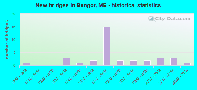
- New bridges - historical statistics
- 11900-1909
- 31930-1939
- 11940-1949
- 21950-1959
- 151960-1969
- 21970-1979
- 21980-1989
- 21990-1999
- 32000-2009
- 32010-2019
- 12020-2022
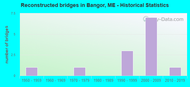
- Reconstructed bridges - Historical Statistics
- 11950-1959
- 01960-1969
- 11970-1979
- 01980-1989
- 31990-1999
- 72000-2009
- 12010-2019
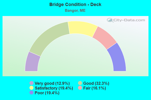
- Bridge Condition - Deck
- 12.9%Very good
- 32.3%Good
- 19.4%Satisfactory
- 16.1%Fair
- 19.4%Poor
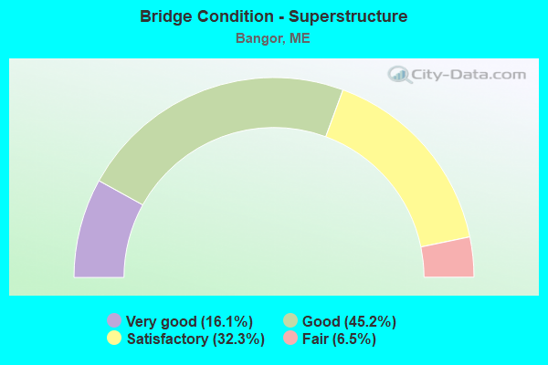
- Bridge Condition - Superstructure
- 16.1%Very good
- 45.2%Good
- 32.3%Satisfactory
- 6.5%Fair
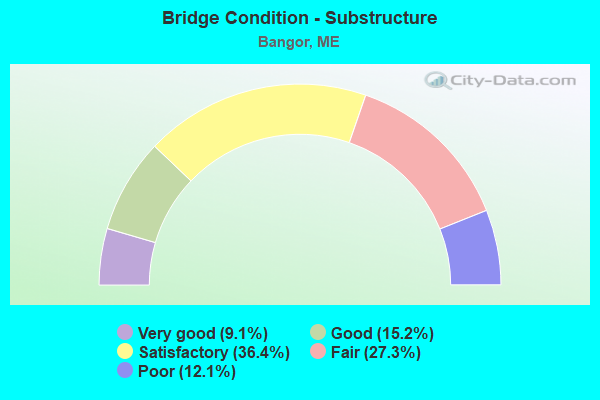
- Bridge Condition - Substructure
- 9.1%Very good
- 15.2%Good
- 36.4%Satisfactory
- 27.3%Fair
- 12.1%Poor
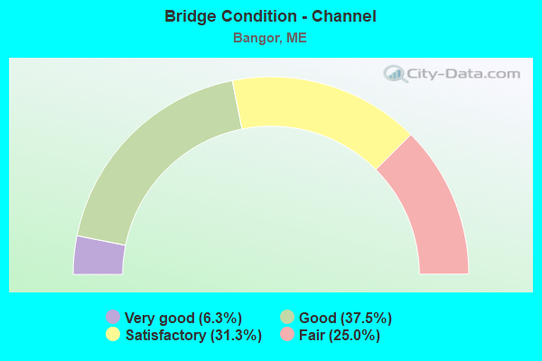
- Bridge Condition - Channel
- 6.3%Very good
- 37.5%Good
- 31.3%Satisfactory
- 25.0%Fair
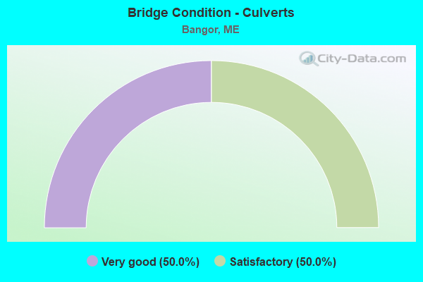
- Bridge Condition - Culverts
- 50.0%Very good
- 50.0%Satisfactory
Find on map >> Show street view
Structure Number: 1427, Location: 0.8 MI N JCT RTE 15 (Lat: 44.824131, Lng: -68.758811), Route carried "on" structure: State highway 95, Year Built: 1960, Status: Open, Structure Length: 7.92m (25.98ft), Average Daily Traffic: 25,150 (year 2016), Truck Traffic: 5%, Average Future Daily Traffic: 35,210 (year 2036), Design Load: HS 20+Mod, Features Intersected: STILLWATER AVENUE
Minimum Vertical Clearance: 30+ m (98+ ft), Kilometerpoint: 190.596, Lanes on structure: 2, Lanes under structure: 2, Base Highway Network: Yes, Owner: State Highway Agency, Approaching Roadway Width: 12.2m (40.0ft), Skew: 5 degrees, Material/Design: Steel, Design/Construction: Stringer/Multi-beam, Number Of Spans In Main Unit: 3, Length of Maximum Span: 27.9m (91.5ft), Curb or Sidewalk Widths: Left: 0.2m (0.7ft), Right: 0.2m (0.7ft), Curb-To-Curb Width: 9.2m (30.2ft), Out-to-Out Width: 10.7m (35.1ft)
Condition: Deck: Poor, Superstructure: Satisfactory, Substructure: Fair, Operating Rating: 62.5 metric tons, Method Used To Determine Operating Rating: Load and Resistance Factor Rating (LRFR) rating reported by rating factor(RF) method using HL-93 loadings, Inventory Rating: 48.3 metric tons, Method Used To Determine Inventory Rating: Load and Resistance Factor Rating (LRFR) rating reported by rating factor(RF) method using HL-93 loadings, Structural Evaluation: Somewhat better than minimum adequacy, Deck Geometry: Meets minimum limits, Underclear: Equal to present minimum criteria, Approach Roadway Alignment: Equal to present desirable criteria, Designated Inspection Frequency: Every 24 months, Inspection Date: September 2021, Deck Structure Type: Concrete Cast-file-Place, Wearing Surface/Protective System: Wearing Surface: Bituminous, Membrane: Preformed Fabric
Find on map >> Show street view
Structure Number: 1428, Location: INTERCHANGE 182 (Lat: 44.786989, Lng: -68.808469), Route carried "on" structure: State highway 95, Year Built: 1960, Year Reconstructed: 2009, Status: Open, Structure Length: 5.55m (18.21ft), Average Daily Traffic: 23,160 (year 2016), Truck Traffic: 5%, Average Future Daily Traffic: 32,424 (year 2036), Design Load: HS 20+Mod, Features Intersected: INDUSTRIAL SPUR (I-395)
Minimum Vertical Clearance: 30+ m (98+ ft), Kilometerpoint: 196.774, Lanes on structure: 2, Lanes under structure: 6, Base Highway Network: Yes, Owner: State Highway Agency, Approaching Roadway Width: 11.9m (39.0ft), Skew: 1 degrees, Material/Design: Steel, Design/Construction: Stringer/Multi-beam, Number Of Spans In Main Unit: 4, Length of Maximum Span: 17.1m (56.1ft), Curb or Sidewalk Widths: Left: 0.2m (0.7ft), Right: 0.2m (0.7ft), Curb-To-Curb Width: 12.3m (40.4ft), Out-to-Out Width: 13.7m (44.9ft)
Condition: Deck: Good, Superstructure: Satisfactory, Substructure: Satisfactory, Operating Rating: 32.4 metric tons, Method Used To Determine Operating Rating: Load and Resistance Factor Rating (LRFR) rating reported by rating factor(RF) method using HL-93 loadings, Inventory Rating: 24.9 metric tons, Method Used To Determine Inventory Rating: Load and Resistance Factor Rating (LRFR) rating reported by rating factor(RF) method using HL-93 loadings, Structural Evaluation: Equal to present minimum criteria, Deck Geometry: Better than present minimum criteria, Underclear: High priority of corrective action, Approach Roadway Alignment: Equal to present desirable criteria, Designated Inspection Frequency: Every 24 months, Inspection Date: September 2020, Deck Structure Type: Concrete Precast Panels, Wearing Surface/Protective System: Wearing Surface: Integral Concrete, Deck Protection: Other
Find on map >> Show street view
Structure Number: 1429, Location: 0.2 MI SW OF I95 / I395 (Lat: 44.783881, Lng: -68.811181), Route carried "on" structure: State highway 95, Year Built: 1962, Year Reconstructed: 2018, Status: Open, Structure Length: 7.60m (24.93ft), Average Daily Traffic: 16,610 (year 2016), Truck Traffic: 5%, Average Future Daily Traffic: 23,254 (year 2036), Design Load: HS 20+Mod, Features Intersected: M C RR & PERRY RD
Minimum Vertical Clearance: 30+ m (98+ ft), Kilometerpoint: 197.193, Lanes on structure: 2, Lanes under structure: 2, Base Highway Network: Yes, Owner: State Highway Agency, Approaching Roadway Width: 12.8m (42.0ft), Material/Design: Steel, Design/Construction: Stringer/Multi-beam, Number Of Spans In Main Unit: 4, Length of Maximum Span: 25.5m (83.7ft), Curb or Sidewalk Widths: Left: 0.2m (0.7ft), Right: 0.2m (0.7ft), Curb-To-Curb Width: 12.2m (40.0ft), Out-to-Out Width: 13.7m (44.9ft)
Condition: Deck: Fair, Superstructure: Good, Substructure: Fair, Operating Rating: 71.0 metric tons, Method Used To Determine Operating Rating: Load and Resistance Factor Rating (LRFR) rating reported by rating factor(RF) method using HL-93 loadings, Inventory Rating: 40.5 metric tons, Method Used To Determine Inventory Rating: Load and Resistance Factor Rating (LRFR) rating reported by rating factor(RF) method using HL-93 loadings, Structural Evaluation: Somewhat better than minimum adequacy, Deck Geometry: Better than present minimum criteria, Underclear: Somewhat better than minimum adequacy, Approach Roadway Alignment: Equal to present minimum criteria, Designated Inspection Frequency: Every 24 months, Inspection Date: November 2020, Deck Structure Type: Concrete Cast-file-Place, Wearing Surface/Protective System: Wearing Surface: Bituminous, Membrane: Preformed Fabric
Find on map >> Show street view
Structure Number: 1558, Location: 0.1 MI E OF JCT RTE 1A (Lat: 44.784119, Lng: -68.774339), Route carried "on" structure: State highway 395, Year Built: 1986, Status: Open, Structure Length: 47.61m (156.20ft), Average Daily Traffic: 16,550 (year 2016), Truck Traffic: 5%, Average Future Daily Traffic: 23,170 (year 2036), Design Load: HS 25 or greater, Features Intersected: PENOBSCOT RV & S MAIN ST
Minimum Vertical Clearance: 30+ m (98+ ft), Kilometerpoint: 3.058, Lanes on structure: 6, Lanes under structure: 4, Base Highway Network: Yes, Owner: State Highway Agency, Approaching Roadway Width: 15.2m (49.9ft), Skew: 30 degrees, Navigation Control: Yes ( Vertical Clearance: 21.3m (69.9ft), Horizontal Clearance: 82.3m (270.0ft)), Material/Design: Steel continuous, Design/Construction: Stringer/Multi-beam, Number Of Spans In Main Unit: 8, Length of Maximum Span: 91.4m (299.9ft), Curb or Sidewalk Widths: Left: 0.2m (0.7ft), Right: 0.2m (0.7ft), Curb-To-Curb Width: 30.7m (100.7ft), Out-to-Out Width: 32.9m (107.9ft)
Condition: Deck: Satisfactory, Superstructure: Satisfactory, Substructure: Satisfactory, Channel: Good, Operating Rating: 42.4 metric tons, Method Used To Determine Operating Rating: Load and Resistance Factor Rating (LRFR) rating reported by rating factor(RF) method using HL-93 loadings, Inventory Rating: 32.7 metric tons, Method Used To Determine Inventory Rating: Load and Resistance Factor Rating (LRFR) rating reported by rating factor(RF) method using HL-93 loadings, Structural Evaluation: Equal to present minimum criteria, Deck Geometry: Superior to present desirable criteria, Underclear: Better than present minimum criteria, Waterway Adequacy: Superior to present desirable criteria, Approach Roadway Alignment: Better than present minimum criteria, Designated Inspection Frequency: Every 24 months, Underwater Inspection Frequency: Every 60 months, Inspection Date: August 2021, Underwater Inspection Date: August 2020, Deck Structure Type: Concrete Cast-file-Place, Wearing Surface/Protective System: Wearing Surface: Bituminous, Membrane: Other
Find on map >> Show street view
Structure Number: 2038, Location: .3MI UPSTR OF JOSH CHAMB (Lat: 44.798881, Lng: -68.764039), Route carried "on" structure: State highway 15, Year Built: 1997, Status: Open, Structure Length: 24.86m (81.56ft), Average Daily Traffic: 24,636 (year 2016), Truck Traffic: 5%, Average Future Daily Traffic: 34,490 (year 2036), Design Load: HS 25 or greater, Features Intersected: PENOBSCOT R & RR YARD, Facility Carried by Structure: STATE ROUTE 1C
Minimum Vertical Clearance: 30+ m (98+ ft), Kilometerpoint: 1.802, Lanes on structure: 4, Base Highway Network: Yes, Owner: State Highway Agency, Approaching Roadway Width: 15.9m (52.2ft), Skew: 1 degrees, Navigation Control: Yes ( Vertical Clearance: 7.3m (24.0ft), Horizontal Clearance: 34.1m (111.9ft)), Material/Design: Steel continuous, Design/Construction: Stringer/Multi-beam, Number Of Spans In Main Unit: 6, Length of Maximum Span: 57.2m (187.7ft), Curb or Sidewalk Widths: Left: 1.8m (5.9ft), Right: 0.1m (0.3ft), Curb-To-Curb Width: 15.9m (52.2ft), Out-to-Out Width: 18.5m (60.7ft)
Condition: Deck: Good, Superstructure: Good, Substructure: Satisfactory, Channel: Satisfactory, Operating Rating: 50.9 metric tons, Method Used To Determine Operating Rating: Load and Resistance Factor Rating (LRFR) rating reported by rating factor(RF) method using HL-93 loadings, Inventory Rating: 39.2 metric tons, Method Used To Determine Inventory Rating: Load and Resistance Factor Rating (LRFR) rating reported by rating factor(RF) method using HL-93 loadings, Structural Evaluation: Equal to present minimum criteria, Deck Geometry: Meets minimum limits, Underclear: Superior to present desirable criteria, Waterway Adequacy: Equal to present desirable criteria, Approach Roadway Alignment: Equal to present desirable criteria, Designated Inspection Frequency: Every 24 months, Underwater Inspection Frequency: Every 60 months, Inspection Date: September 2021, Underwater Inspection Date: November 2019, Deck Structure Type: Concrete Cast-file-Place, Wearing Surface/Protective System: Wearing Surface: Bituminous, Membrane: Preformed Fabric
Find on map >> Show street view
Structure Number: 2294, Location: 300' E ROUTE 2 (Lat: 44.802911, Lng: -68.772261), Route carried "on" structure: City street , Year Built: 1931, Year Reconstructed: 2000, Status: Open, Structure Length: 1.74m (5.71ft), Average Daily Traffic: 4,257 (year 2016), Truck Traffic: 5%, Average Future Daily Traffic: 5,960 (year 2036), Design Load: HS 25 or greater, Features Intersected: KENDUSKEAG STREAM, Facility Carried by Structure: FRANKLIN STREET
Minimum Vertical Clearance: 30+ m (98+ ft), Kilometerpoint: 0.129, Lanes on structure: 2, Owner: State Highway Agency, Approaching Roadway Width: 20.1m (65.9ft), Material/Design: Prestressed concrete, Design/Construction: Stringer/Multi-beam, Number Of Spans In Main Unit: 1, Length of Maximum Span: 16.8m (55.1ft), Curb or Sidewalk Widths: Left: 2.4m (7.9ft), Right: 2.1m (6.9ft), Curb-To-Curb Width: 14.6m (47.9ft), Out-to-Out Width: 20.1m (65.9ft)
Condition: Deck: Good, Superstructure: Good, Substructure: Satisfactory, Channel: Fair, Operating Rating: 65.4 metric tons, Method Used To Determine Operating Rating: Load and Resistance Factor Rating (LRFR) rating reported by rating factor(RF) method using HL-93 loadings, Inventory Rating: 50.5 metric tons, Method Used To Determine Inventory Rating: Load and Resistance Factor Rating (LRFR) rating reported by rating factor(RF) method using HL-93 loadings, Structural Evaluation: Equal to present minimum criteria, Deck Geometry: Superior to present desirable criteria, Waterway Adequacy: Superior to present desirable criteria, Approach Roadway Alignment: Equal to present desirable criteria, Designated Inspection Frequency: Every 24 months, Inspection Date: August 2020, Deck Structure Type: Concrete Precast Panels, Wearing Surface/Protective System: Wearing Surface: Bituminous, Membrane: Preformed Fabric, Deck Protection: Epoxy Coated Reinforcing
Find on map >> Show street view
Structure Number: 2771, Location: 400' W OF JCT RTE 221 (Lat: 44.861650, Lng: -68.831311), Route carried "on" structure: State highway 15, Year Built: 1979, Status: Open, Structure Length: 4.31m (14.14ft), Average Daily Traffic: 8,925 (year 2016), Truck Traffic: 5%, Average Future Daily Traffic: 12,495 (year 2036), Design Load: H 20, Features Intersected: KENDUSKEAG STREAM
Minimum Vertical Clearance: 30+ m (98+ ft), Kilometerpoint: 108.599, Lanes on structure: 2, Base Highway Network: Yes, Owner: State Highway Agency, Approaching Roadway Width: 12.2m (40.0ft), Material/Design: Steel continuous, Design/Construction: Stringer/Multi-beam, Number Of Spans In Main Unit: 2, Length of Maximum Span: 21.3m (69.9ft), Curb or Sidewalk Widths: Left: 0.2m (0.7ft), Right: 0.2m (0.7ft), Curb-To-Curb Width: 11.9m (39.0ft), Out-to-Out Width: 13.0m (42.7ft)
Condition: Deck: Satisfactory, Superstructure: Good, Substructure: Good, Channel: Fair, Operating Rating: 81.6 metric tons, Method Used To Determine Operating Rating: Load and Resistance Factor Rating (LRFR) rating reported by rating factor(RF) method using HL-93 loadings, Inventory Rating: 62.9 metric tons, Method Used To Determine Inventory Rating: Load and Resistance Factor Rating (LRFR) rating reported by rating factor(RF) method using HL-93 loadings, Structural Evaluation: Better than present minimum criteria, Deck Geometry: Somewhat better than minimum adequacy, Waterway Adequacy: Equal to present desirable criteria, Approach Roadway Alignment: Equal to present desirable criteria, Designated Inspection Frequency: Every 24 months, Inspection Date: December 2020, Deck Structure Type: Concrete Cast-file-Place, Wearing Surface/Protective System: Wearing Surface: Latex Concrete
Find on map >> Show street view
Structure Number: 2857, Location: RT-1A INTERSECT 395 MAIN (Lat: 44.781019, Lng: -68.782011), Year Built: 1930, Status: Open, Structure Length: 2.68m (8.79ft), Average Future Daily Traffic: 10,570 (year 2034), Features Intersected: STATE ROUTE 1A
Lanes under structure: 2, Owner: Railroad, Skew: 4 degrees, Material/Design: Steel, Design/Construction: Girder and Floorbeam System, Number Of Spans In Main Unit: 1, Length of Maximum Span: 23.2m (76.1ft), Curb or Sidewalk Widths: Left: 0.9m (3.0ft), Right: 0.0m, Out-to-Out Width: 4.0m (13.1ft)
Condition: Substructure: Poor, Underclear: High priority of corrective action, Designated Inspection Frequency: Every 24 months, Inspection Date: December 2020
Find on map >> Show street view
Structure Number: 3079, Location: CENTER OF CITY (Lat: 44.801911, Lng: -68.770261), Route carried "on" structure: State highway 2, Year Built: 1976, Status: Open, Structure Length: 4.18m (13.71ft), Average Daily Traffic: 8,231 (year 2016), Truck Traffic: 5%, Average Future Daily Traffic: 11,523 (year 2036), Design Load: HS 20+Mod, Features Intersected: KENDUSKEAG STREAM
Minimum Vertical Clearance: 30+ m (98+ ft), Kilometerpoint: 231.826, Lanes on structure: 2, Base Highway Network: Yes, Owner: State Highway Agency, Approaching Roadway Width: 14.9m (48.9ft), Material/Design: Steel, Design/Construction: Stringer/Multi-beam, Number Of Spans In Main Unit: 2, Length of Maximum Span: 13.4m (44.0ft), Curb or Sidewalk Widths: Left: 3.5m (11.5ft), Right: 3.5m (11.5ft), Curb-To-Curb Width: 14.9m (48.9ft), Out-to-Out Width: 21.9m (71.9ft)
Condition: Deck: Satisfactory, Superstructure: Good, Substructure: Poor, Channel: Good, Operating Rating: 80.4 metric tons, Method Used To Determine Operating Rating: Load and Resistance Factor Rating (LRFR) rating reported by rating factor(RF) method using HL-93 loadings, Inventory Rating: 62.2 metric tons, Method Used To Determine Inventory Rating: Load and Resistance Factor Rating (LRFR) rating reported by rating factor(RF) method using HL-93 loadings, Structural Evaluation: Meets minimum limits, Deck Geometry: Superior to present desirable criteria, Waterway Adequacy: Superior to present desirable criteria, Approach Roadway Alignment: Equal to present desirable criteria, Designated Inspection Frequency: Every 24 months, Inspection Date: December 2020, Deck Structure Type: Concrete Cast-file-Place, Wearing Surface/Protective System: Wearing Surface: Latex Concrete
Find on map >> Show street view
Structure Number: 3301, Location: 0.2 MI NE OF JCT OHIO ST (Lat: 44.826061, Lng: -68.806350), Route carried "on" structure: State highway , Year Built: 1992, Status: Open, Structure Length: 4.63m (15.19ft), Average Daily Traffic: 12,007 (year 2016), Truck Traffic: 5%, Average Future Daily Traffic: 16,810 (year 2036), Design Load: HS 25 or greater, Features Intersected: KENDUSKEAG STREAM, Facility Carried by Structure: GRIFFIN ROAD
Minimum Vertical Clearance: 30+ m (98+ ft), Kilometerpoint: 2.044, Lanes on structure: 2, Base Highway Network: Yes, Owner: State Highway Agency, Approaching Roadway Width: 12.5m (41.0ft), Material/Design: Steel, Design/Construction: Stringer/Multi-beam, Number Of Spans In Main Unit: 1, Length of Maximum Span: 45.4m (149.0ft), Curb or Sidewalk Widths: Left: 1.8m (5.9ft), Right: 0.2m (0.7ft), Curb-To-Curb Width: 12.2m (40.0ft), Out-to-Out Width: 15.2m (49.9ft)
Condition: Deck: Good, Superstructure: Very good, Substructure: Fair, Channel: Satisfactory, Operating Rating: 53.5 metric tons, Method Used To Determine Operating Rating: Load and Resistance Factor Rating (LRFR) rating reported by rating factor(RF) method using HL-93 loadings, Inventory Rating: 41.1 metric tons, Method Used To Determine Inventory Rating: Load and Resistance Factor Rating (LRFR) rating reported by rating factor(RF) method using HL-93 loadings, Structural Evaluation: Somewhat better than minimum adequacy, Deck Geometry: Somewhat better than minimum adequacy, Waterway Adequacy: Superior to present desirable criteria, Approach Roadway Alignment: Equal to present desirable criteria, Designated Inspection Frequency: Every 24 months, Inspection Date: December 2021, Deck Structure Type: Concrete Cast-file-Place, Wearing Surface/Protective System: Wearing Surface: Integral Concrete
Find on map >> Show street view
Structure Number: 3905, Location: 0.1 MI NW OF JCT 14TH ST (Lat: 44.813239, Lng: -68.783631), Route carried "on" structure: City street , Year Built: 1946, Year Reconstructed: 2008, Status: Open, Structure Length: 4.42m (14.50ft), Average Daily Traffic: 2,218 (year 2016), Truck Traffic: 5%, Average Future Daily Traffic: 3,105 (year 2036), Design Load: H 15, Features Intersected: KENDUSKEAG STREAM, Facility Carried by Structure: VALLEY AVENUE
Minimum Vertical Clearance: 30+ m (98+ ft), Kilometerpoint: 1.014, Lanes on structure: 2, Owner: State Highway Agency, Approaching Roadway Width: 9.1m (29.9ft), Skew: 2 degrees, Material/Design: Concrete, Design/Construction: Tee Beam, Number Of Spans In Main Unit: 2, Length of Maximum Span: 21.0m (68.9ft), Curb or Sidewalk Widths: Left: 0.1m (0.3ft), Right: 0.1m (0.3ft), Curb-To-Curb Width: 7.5m (24.6ft), Out-to-Out Width: 8.5m (27.9ft)
Condition: Deck: Satisfactory, Superstructure: Good, Substructure: Good, Channel: Good, Operating Rating: 26.2 metric tons, Method Used To Determine Operating Rating: Load and Resistance Factor Rating (LRFR) rating reported by rating factor(RF) method using HL-93 loadings, Inventory Rating: 20.1 metric tons, Method Used To Determine Inventory Rating: Load and Resistance Factor Rating (LRFR) rating reported by rating factor(RF) method using HL-93 loadings, Structural Evaluation: Somewhat better than minimum adequacy, Deck Geometry: High priority of replacement, Waterway Adequacy: Equal to present desirable criteria, Approach Roadway Alignment: Equal to present minimum criteria, Designated Inspection Frequency: Every 24 months, Inspection Date: August 2020, Deck Structure Type: Concrete Cast-file-Place, Wearing Surface/Protective System: Wearing Surface: Latex Concrete
Find on map >> Show street view
Structure Number: 5312, Location: 1 MI N OF I-395 (Lat: 44.796231, Lng: -68.768139), Route carried "on" structure: Alternate State highway 1, Year Built: 1955, Year Reconstructed: 2013, Status: Open, Structure Length: 43.01m (141.11ft), Average Daily Traffic: 14,431 (year 2016), Truck Traffic: 5%, Average Future Daily Traffic: 20,203 (year 2036), Design Load: HS 20, Features Intersected: PENOBSCOT R/ STREET/ RR
Minimum Vertical Clearance: 30+ m (98+ ft), Kilometerpoint: 62.636, Lanes on structure: 2, Lanes under structure: 5, Base Highway Network: Yes, Owner: State Highway Agency, Approaching Roadway Width: 9.8m (32.2ft), Navigation Control: Yes ( Vertical Clearance: 7.0m (23.0ft), Horizontal Clearance: 46.3m (151.9ft)), Material/Design: Steel continuous, Design/Construction: Stringer/Multi-beam, Number Of Spans In Main Unit: 5, Number Of Approach Spans: 12, Length of Maximum Span: 54.9m (180.1ft), Curb or Sidewalk Widths: Left: 0.2m (0.7ft), Right: 0.2m (0.7ft), Curb-To-Curb Width: 8.5m (27.9ft), Out-to-Out Width: 13.3m (43.6ft)
Condition: Deck: Good, Superstructure: Good, Substructure: Fair, Channel: Good, Operating Rating: 42.1 metric tons, Method Used To Determine Operating Rating: Load and Resistance Factor Rating (LRFR) rating reported by rating factor(RF) method using HL-93 loadings, Inventory Rating: 32.4 metric tons, Method Used To Determine Inventory Rating: Load and Resistance Factor Rating (LRFR) rating reported by rating factor(RF) method using HL-93 loadings, Structural Evaluation: Somewhat better than minimum adequacy, Deck Geometry: Meets minimum limits, Underclear: Meets minimum limits, Waterway Adequacy: Superior to present desirable criteria, Approach Roadway Alignment: Somewhat better than minimum adequacy, Designated Inspection Frequency: Every 24 months, Critical Feature Inspection Frequency: Every 24 months, Underwater Inspection Frequency: Every 60 months, Inspection Date: November 2020, Critical Feature Inspection Date: November 2020, Underwater Inspection Date: November 2019, Deck Structure Type: Concrete Precast Panels, Wearing Surface/Protective System: Wearing Surface: Bituminous, Membrane: Preformed Fabric
Find on map >> Show street view
Structure Number: 5413, Location: .1 MI SO TOWNLINE (Lat: 44.866439, Lng: -68.841839), Year Built: 1907, Status: Open, Structure Length: 2.29m (7.51ft), Average Daily Traffic: 8,675 (year 2018), Truck Traffic: 5%, Average Future Daily Traffic: 12,012 (year 2034), Design Load: Railroad, Features Intersected: BROADWAY - ROUTE 15
Lanes under structure: 2, Owner: Railroad, Skew: 2 degrees, Material/Design: Steel, Design/Construction: Girder and Floorbeam System, Number Of Spans In Main Unit: 1, Length of Maximum Span: 20.4m (66.9ft), Out-to-Out Width: 4.3m (14.1ft)
Condition: Substructure: Fair, Underclear: Meets minimum limits, Designated Inspection Frequency: Every 24 months, Inspection Date: December 2021
Find on map >> Show street view
Structure Number: 5423, Location: 0.2 MI SE OF GRIFFIN RD (Lat: 44.817611, Lng: -68.811419), Route carried "on" structure: State highway 222, Year Built: 1956, Year Reconstructed: 1964, Status: Open, Structure Length: 0.98m (3.22ft), Average Daily Traffic: 16,810 (year 2016), Truck Traffic: 5%, Average Future Daily Traffic: 23,534 (year 2036), Design Load: H 20, Features Intersected: GRIFFIN BROOK
Minimum Vertical Clearance: 30+ m (98+ ft), Kilometerpoint: 40.893, Lanes on structure: 4, Base Highway Network: Yes, Owner: State Highway Agency, Approaching Roadway Width: 14.6m (47.9ft), Material/Design: Concrete, Design/Construction: Culvert, Number Of Spans In Main Unit: 2, Length of Maximum Span: 4.3m (14.1ft)
Condition: Channel: Satisfactory, Culverts: Satisfactory, Operating Rating: 20.1 metric tons, Method Used To Determine Operating Rating: Load and Resistance Factor Rating (LRFR) rating reported by rating factor(RF) method using HL-93 loadings, Inventory Rating: 15.6 metric tons, Method Used To Determine Inventory Rating: Load and Resistance Factor Rating (LRFR) rating reported by rating factor(RF) method using HL-93 loadings, Structural Evaluation: High priority of corrective action, Waterway Adequacy: Superior to present desirable criteria, Approach Roadway Alignment: Equal to present desirable criteria, Designated Inspection Frequency: Every 24 months, Inspection Date: June 2021
Find on map >> Show street view
Structure Number: 5694, Location: .1 MI NW KENDUSKEAG AVE (Lat: 44.808211, Lng: -68.778361), Route carried "on" structure: County highway , Year Built: 1961, Year Reconstructed: 1999, Status: Open, Structure Length: 6.40m (21.00ft), Average Daily Traffic: 7,158 (year 2016), Truck Traffic: 5%, Average Future Daily Traffic: 10,021 (year 2036), Design Load: H 20, Features Intersected: KENDUSKEAG STREAM, Facility Carried by Structure: HARLOW STREET
Minimum Vertical Clearance: 30+ m (98+ ft), Kilometerpoint: 0.290, Lanes on structure: 2, Owner: State Highway Agency, Approaching Roadway Width: 11.0m (36.1ft), Skew: 4 degrees, Material/Design: Steel continuous, Design/Construction: Stringer/Multi-beam, Number Of Spans In Main Unit: 3, Length of Maximum Span: 21.3m (69.9ft), Curb or Sidewalk Widths: Left: 1.5m (4.9ft), Right: 0.0m, Curb-To-Curb Width: 9.0m (29.5ft), Out-to-Out Width: 11.2m (36.7ft)
Condition: Deck: Good, Superstructure: Good, Substructure: Good, Channel: Satisfactory, Operating Rating: 44.4 metric tons, Method Used To Determine Operating Rating: Load and Resistance Factor Rating (LRFR) rating reported by rating factor(RF) method using HL-93 loadings, Inventory Rating: 34.0 metric tons, Method Used To Determine Inventory Rating: Load and Resistance Factor Rating (LRFR) rating reported by rating factor(RF) method using HL-93 loadings, Structural Evaluation: Better than present minimum criteria, Deck Geometry: Meets minimum limits, Waterway Adequacy: Superior to present desirable criteria, Approach Roadway Alignment: Equal to present desirable criteria, Designated Inspection Frequency: Every 24 months, Inspection Date: August 2020, Deck Structure Type: Concrete Cast-file-Place, Wearing Surface/Protective System: Wearing Surface: Bituminous, Membrane: Preformed Fabric
Find on map >> Show street view
Structure Number: 5789, Location: INTERCHANGE #48 (Lat: 44.819311, Lng: -68.775419), Route carried "on" structure: State highway 95, Year Built: 1960, Status: Open, Structure Length: 4.45m (14.60ft), Average Daily Traffic: 25,340 (year 2016), Truck Traffic: 5%, Average Future Daily Traffic: 35,476 (year 2036), Design Load: HS 20+Mod, Features Intersected: ROUTE 15
Minimum Vertical Clearance: 30+ m (98+ ft), Kilometerpoint: 295.880, Lanes on structure: 4, Lanes under structure: 5, Base Highway Network: Yes, Owner: State Highway Agency, Approaching Roadway Width: 12.2m (40.0ft), Skew: 23 degrees, Material/Design: Steel, Design/Construction: Stringer/Multi-beam, Number Of Spans In Main Unit: 3, Length of Maximum Span: 25.0m (82.0ft), Curb or Sidewalk Widths: Left: 0.2m (0.7ft), Right: 0.2m (0.7ft), Curb-To-Curb Width: 27.5m (90.2ft), Out-to-Out Width: 28.1m (92.2ft)
Condition: Deck: Poor, Superstructure: Fair, Substructure: Fair, Operating Rating: 37.9 metric tons, Method Used To Determine Operating Rating: Load and Resistance Factor Rating (LRFR) rating reported by rating factor(RF) method using HL-93 loadings, Inventory Rating: 29.2 metric tons, Method Used To Determine Inventory Rating: Load and Resistance Factor Rating (LRFR) rating reported by rating factor(RF) method using HL-93 loadings, Structural Evaluation: Somewhat better than minimum adequacy, Deck Geometry: Superior to present desirable criteria, Underclear: Meets minimum limits, Approach Roadway Alignment: Better than present minimum criteria, Designated Inspection Frequency: Every 24 months, Inspection Date: June 2021, Deck Structure Type: Concrete Cast-file-Place, Wearing Surface/Protective System: Wearing Surface: Bituminous, Membrane: Preformed Fabric
Find on map >> Show street view
Structure Number: 579, Location: INTERCHANGE #47 (Lat: 44.811431, Lng: -68.790911), Route carried "on" structure: County highway , Year Built: 2021, Status: Open, Structure Length: 5.64m (18.50ft), Average Daily Traffic: 10,432 (year 2016), Truck Traffic: 5%, Average Future Daily Traffic: 14,605 (year 2036), Design Load: HL 93, Features Intersected: INTERSTATE 95, Facility Carried by Structure: SA 6
Minimum Vertical Clearance: 30+ m (98+ ft), Kilometerpoint: 1.867, Lanes on structure: 2, Lanes under structure: 6, Owner: State Highway Agency, Approaching Roadway Width: 16.5m (54.1ft), Material/Design: Steel, Design/Construction: Stringer/Multi-beam, Number Of Spans In Main Unit: 2, Length of Maximum Span: 27.4m (89.9ft), Curb or Sidewalk Widths: Left: 0.0m, Right: 1.8m (5.9ft), Curb-To-Curb Width: 13.7m (44.9ft), Out-to-Out Width: 16.5m (54.1ft)
Condition: Deck: Good, Superstructure: Very good, Substructure: Very good, Operating Rating: 63.8 metric tons, Method Used To Determine Operating Rating: Load and Resistance Factor Rating (LRFR) rating reported by rating factor(RF) method using HL-93 loadings, Inventory Rating: 49.2 metric tons, Method Used To Determine Inventory Rating: Load and Resistance Factor Rating (LRFR) rating reported by rating factor(RF) method using HL-93 loadings, Structural Evaluation: Equal to present desirable criteria, Deck Geometry: Superior to present desirable criteria, Underclear: Meets minimum limits, Approach Roadway Alignment: Equal to present desirable criteria, Designated Inspection Frequency: Every 24 months, Inspection Date: June 2021, Deck Structure Type: Concrete Cast-file-Place, Wearing Surface/Protective System: Wearing Surface: Monolithic Concrete
Find on map >> Show street view
Structure Number: 5791, Location: 0.7 MI W JCT RTE 15 (Lat: 44.814711, Lng: -68.788539), Route carried "on" structure: State highway 95, Year Built: 1960, Year Reconstructed: 2003, Status: Open, Structure Length: 13.14m (43.11ft), Average Daily Traffic: 25,340 (year 2016), Truck Traffic: 5%, Average Future Daily Traffic: 35,476 (year 2036), Design Load: HS 20+Mod, Features Intersected: KENDUSKEAG STR&VALLEY AV
Minimum Vertical Clearance: 30+ m (98+ ft), Kilometerpoint: 294.672, Lanes on structure: 4, Lanes under structure: 2, Base Highway Network: Yes, Owner: State Highway Agency, Approaching Roadway Width: 21.0m (68.9ft), Skew: 1 degrees, Material/Design: Concrete continuous, Design/Construction: Tee Beam, Number Of Spans In Main Unit: 3, Length of Maximum Span: 45.7m (149.9ft), Curb or Sidewalk Widths: Left: 0.2m (0.7ft), Right: 0.2m (0.7ft), Curb-To-Curb Width: 18.5m (60.7ft), Out-to-Out Width: 20.8m (68.2ft)
Condition: Deck: Fair, Superstructure: Satisfactory, Substructure: Good, Channel: Good, Operating Rating: 41.8 metric tons, Method Used To Determine Operating Rating: Load and Resistance Factor Rating (LRFR) rating reported by rating factor(RF) method using HL-93 loadings, Inventory Rating: 32.4 metric tons, Method Used To Determine Inventory Rating: Load and Resistance Factor Rating (LRFR) rating reported by rating factor(RF) method using HL-93 loadings, Structural Evaluation: Equal to present minimum criteria, Deck Geometry: Meets minimum limits, Underclear: High priority of corrective action, Waterway Adequacy: Superior to present desirable criteria, Approach Roadway Alignment: Equal to present minimum criteria, Designated Inspection Frequency: Every 24 months, Inspection Date: June 2021, Deck Structure Type: Concrete Cast-file-Place, Wearing Surface/Protective System: Wearing Surface: Bituminous, Membrane: Preformed Fabric
Find on map >> Show street view
Structure Number: 5794, Location: INTERCHANGE #46 (Lat: 44.798550, Lng: -68.801950), Route carried "on" structure: State highway 2, Year Built: 2010, Status: Open, Structure Length: 5.31m (17.42ft), Average Daily Traffic: 13,414 (year 2016), Truck Traffic: 5%, Average Future Daily Traffic: 18,780 (year 2036), Design Load: HS 25 or greater, Features Intersected: I-95
Minimum Vertical Clearance: 30+ m (98+ ft), Kilometerpoint: 229.251, Lanes on structure: 2, Lanes under structure: 5, Base Highway Network: Yes, Owner: State Highway Agency, Approaching Roadway Width: 15.5m (50.9ft), Skew: 2 degrees, Material/Design: Prestressed concrete, Design/Construction: Stringer/Multi-beam, Number Of Spans In Main Unit: 2, Length of Maximum Span: 26.1m (85.6ft), Curb or Sidewalk Widths: Left: 1.6m (5.2ft), Right: 1.6m (5.2ft), Curb-To-Curb Width: 15.5m (50.9ft), Out-to-Out Width: 19.5m (64.0ft)
Condition: Deck: Very good, Superstructure: Very good, Substructure: Very good, Channel: Very good, Operating Rating: 43.1 metric tons, Method Used To Determine Operating Rating: Load and Resistance Factor Rating (LRFR) rating reported by rating factor(RF) method using HL-93 loadings, Inventory Rating: 33.0 metric tons, Method Used To Determine Inventory Rating: Load and Resistance Factor Rating (LRFR) rating reported by rating factor(RF) method using HL-93 loadings, Structural Evaluation: Equal to present desirable criteria, Deck Geometry: Superior to present desirable criteria, Underclear: Equal to present minimum criteria, Approach Roadway Alignment: Equal to present desirable criteria, Designated Inspection Frequency: Every 24 months, Inspection Date: December 2021, Deck Structure Type: Concrete Cast-file-Place, Wearing Surface/Protective System: Wearing Surface: Bituminous, Membrane: Preformed Fabric
Find on map >> Show street view
Structure Number: 5795, Location: INTERCHANGE 182 (Lat: 44.786961, Lng: -68.808211), Route carried "on" structure: State highway 95, Year Built: 1960, Year Reconstructed: 2009, Status: Open, Structure Length: 5.55m (18.21ft), Average Daily Traffic: 14,260 (year 2016), Truck Traffic: 5%, Average Future Daily Traffic: 19,964 (year 2036), Design Load: HS 20+Mod, Features Intersected: INDSTRIAL SPUR (I-395)
Minimum Vertical Clearance: 30+ m (98+ ft), Kilometerpoint: 291.146, Lanes on structure: 2, Lanes under structure: 6, Base Highway Network: Yes, Owner: State Highway Agency, Approaching Roadway Width: 12.8m (42.0ft), Skew: 1 degrees, Material/Design: Steel, Design/Construction: Stringer/Multi-beam, Number Of Spans In Main Unit: 4, Length of Maximum Span: 17.1m (56.1ft), Curb or Sidewalk Widths: Left: 0.2m (0.7ft), Right: 0.2m (0.7ft), Curb-To-Curb Width: 12.3m (40.4ft), Out-to-Out Width: 13.7m (44.9ft)
Condition: Deck: Very good, Superstructure: Satisfactory, Substructure: Satisfactory, Operating Rating: 32.4 metric tons, Method Used To Determine Operating Rating: Load and Resistance Factor Rating (LRFR) rating reported by rating factor(RF) method using HL-93 loadings, Inventory Rating: 24.9 metric tons, Method Used To Determine Inventory Rating: Load and Resistance Factor Rating (LRFR) rating reported by rating factor(RF) method using HL-93 loadings, Structural Evaluation: Equal to present minimum criteria, Deck Geometry: Better than present minimum criteria, Underclear: High priority of corrective action, Approach Roadway Alignment: Equal to present desirable criteria, Designated Inspection Frequency: Every 24 months, Inspection Date: September 2020, Deck Structure Type: Concrete Precast Panels, Wearing Surface/Protective System: Wearing Surface: Integral Concrete, Deck Protection: Other
Find on map >> Show street view
Structure Number: 5796, Location: 0.3 MI E OF I-95 (Lat: 44.786381, Lng: -68.802861), Route carried "on" structure: State highway 395, Year Built: 2016, Status: Open, Structure Length: 1.06m (3.48ft), Average Daily Traffic: 18,710 (year 2016), Truck Traffic: 5%, Average Future Daily Traffic: 26,194 (year 2036), Design Load: Greater than HL93, Features Intersected: WEBSTER AVENUE
Minimum Vertical Clearance: 30+ m (98+ ft), Kilometerpoint: 0.772, Lanes on structure: 6, Base Highway Network: Yes, Owner: State Highway Agency, Approaching Roadway Width: 28.0m (91.9ft), Skew: 32 degrees, Material/Design: Concrete, Design/Construction: Culvert, Number Of Spans In Main Unit: 1, Length of Maximum Span: 9.6m (31.5ft)
Condition: Culverts: Very good, Operating Rating: 55.1 metric tons, Method Used To Determine Operating Rating: Load and Resistance Factor Rating (LRFR) rating reported by rating factor(RF) method using HL-93 loadings, Inventory Rating: 38.9 metric tons, Method Used To Determine Inventory Rating: Load and Resistance Factor Rating (LRFR) rating reported by rating factor(RF) method using HL-93 loadings, Structural Evaluation: Equal to present desirable criteria, Approach Roadway Alignment: Equal to present desirable criteria, Designated Inspection Frequency: Every 24 months, Inspection Date: August 2021
Find on map >> Show street view
Structure Number: 5797, Location: INTERCHANGE #47 (Lat: 44.808811, Lng: -68.793361), Route carried "on" structure: State highway 222, Year Built: 2016, Status: Open, Structure Length: 5.85m (19.19ft), Average Daily Traffic: 16,488 (year 2016), Truck Traffic: 5%, Average Future Daily Traffic: 23,083 (year 2036), Design Load: Greater than HL93, Features Intersected: INTERSTATE 95
Minimum Vertical Clearance: 30+ m (98+ ft), Kilometerpoint: 42.615, Lanes on structure: 4, Lanes under structure: 5, Base Highway Network: Yes, Owner: State Highway Agency, Approaching Roadway Width: 18.0m (59.1ft), Design/Construction: Stringer/Multi-beam, Number Of Spans In Main Unit: 2, Length of Maximum Span: 27.6m (90.6ft), Curb or Sidewalk Widths: Left: 1.8m (5.9ft), Right: 1.8m (5.9ft), Curb-To-Curb Width: 18.0m (59.1ft), Out-to-Out Width: 22.6m (74.1ft)
Condition: Deck: Very good, Superstructure: Very good, Substructure: Very good, Operating Rating: 49.6 metric tons, Method Used To Determine Operating Rating: Load and Resistance Factor Rating (LRFR) rating reported by rating factor(RF) method using HL-93 loadings, Inventory Rating: 38.2 metric tons, Method Used To Determine Inventory Rating: Load and Resistance Factor Rating (LRFR) rating reported by rating factor(RF) method using HL-93 loadings, Structural Evaluation: Equal to present desirable criteria, Deck Geometry: Somewhat better than minimum adequacy, Underclear: Somewhat better than minimum adequacy, Approach Roadway Alignment: Equal to present desirable criteria, Designated Inspection Frequency: Every 24 months, Inspection Date: September 2021, Deck Structure Type: Concrete Cast-file-Place, Wearing Surface/Protective System: Wearing Surface: Bituminous, Membrane: Preformed Fabric
Find on map >> Show street view
Structure Number: 5798, Location: 0.5 MI S OF JCT RTE 15 (Lat: 44.816731, Lng: -68.784931), Route carried "on" structure: County highway , Year Built: 1960, Status: Open, Structure Length: 7.00m (22.97ft), Average Daily Traffic: 3,020 (year 2016), Truck Traffic: 5%, Average Future Daily Traffic: 4,228 (year 2036), Design Load: H 20, Features Intersected: INTERSTATE 95, Facility Carried by Structure: KENDUSKEAG AVENUE
Minimum Vertical Clearance: 30+ m (98+ ft), Kilometerpoint: 1.432, Lanes on structure: 2, Lanes under structure: 4, Owner: State Highway Agency, Approaching Roadway Width: 11.6m (38.1ft), Skew: 3 degrees, Material/Design: Steel, Design/Construction: Stringer/Multi-beam, Number Of Spans In Main Unit: 4, Length of Maximum Span: 18.0m (59.1ft), Curb or Sidewalk Widths: Left: 0.9m (3.0ft), Right: 0.9m (3.0ft), Curb-To-Curb Width: 8.0m (26.2ft), Out-to-Out Width: 10.4m (34.1ft)
Condition: Deck: Fair, Superstructure: Satisfactory, Substructure: Satisfactory, Channel: Fair, Operating Rating: 44.1 metric tons, Method Used To Determine Operating Rating: Load and Resistance Factor Rating (LRFR) rating reported by rating factor(RF) method using HL-93 loadings, Inventory Rating: 34.0 metric tons, Method Used To Determine Inventory Rating: Load and Resistance Factor Rating (LRFR) rating reported by rating factor(RF) method using HL-93 loadings, Structural Evaluation: Equal to present minimum criteria, Deck Geometry: High priority of corrective action, Underclear: Meets minimum limits, Approach Roadway Alignment: Better than present minimum criteria, Designated Inspection Frequency: Every 24 months, Inspection Date: June 2021, Deck Structure Type: Concrete Cast-file-Place, Wearing Surface/Protective System: Wearing Surface: Monolithic Concrete
Find on map >> Show street view
Structure Number: 5799, Location: I395 INTERCHANGE #3 (Lat: 44.785539, Lng: -68.779569), Route carried "on" structure: State highway 395, Year Built: 1986, Status: Open, Structure Length: 3.57m (11.71ft), Average Daily Traffic: 13,290 (year 2016), Truck Traffic: 5%, Average Future Daily Traffic: 18,606 (year 2036), Design Load: HS 25 or greater, Features Intersected: ROUTES US 1A & 9
Minimum Vertical Clearance: 30+ m (98+ ft), Kilometerpoint: 2.688, Lanes on structure: 6, Lanes under structure: 6, Base Highway Network: Yes, Owner: State Highway Agency, Approaching Roadway Width: 11.6m (38.1ft), Skew: 30 degrees, Material/Design: Steel, Design/Construction: Stringer/Multi-beam, Number Of Spans In Main Unit: 1, Length of Maximum Span: 34.0m (111.5ft), Curb or Sidewalk Widths: Left: 0.2m (0.7ft), Right: 0.2m (0.7ft), Curb-To-Curb Width: 38.8m (127.3ft), Out-to-Out Width: 43.2m (141.7ft)
Condition: Deck: Satisfactory, Superstructure: Good, Substructure: Fair, Operating Rating: 48.3 metric tons, Method Used To Determine Operating Rating: Load and Resistance Factor Rating (LRFR) rating reported by rating factor(RF) method using HL-93 loadings, Inventory Rating: 37.3 metric tons, Method Used To Determine Inventory Rating: Load and Resistance Factor Rating (LRFR) rating reported by rating factor(RF) method using HL-93 loadings, Structural Evaluation: Somewhat better than minimum adequacy, Deck Geometry: Superior to present desirable criteria, Underclear: Better than present minimum criteria, Approach Roadway Alignment: Equal to present desirable criteria, Designated Inspection Frequency: Every 24 months, Inspection Date: September 2021, Deck Structure Type: Concrete Cast-file-Place, Wearing Surface/Protective System: Wearing Surface: Bituminous, Membrane: Preformed Fabric
Find on map >> Show street view
Structure Number: 58, Location: 0.8 MI N JCT RTE 15 (Lat: 44.823519, Lng: -68.759319), Route carried "on" structure: State highway 95, Year Built: 1960, Year Reconstructed: 2006, Status: Open, Structure Length: 6.71m (22.01ft), Average Daily Traffic: 25,120 (year 2016), Truck Traffic: 5%, Average Future Daily Traffic: 35,168 (year 2036), Design Load: HS 20+Mod, Features Intersected: STILLWATER AVENUE
Minimum Vertical Clearance: 30+ m (98+ ft), Kilometerpoint: 297.117, Lanes on structure: 2, Lanes under structure: 2, Base Highway Network: Yes, Owner: State Highway Agency, Approaching Roadway Width: 12.2m (40.0ft), Skew: 5 degrees, Material/Design: Steel, Design/Construction: Stringer/Multi-beam, Number Of Spans In Main Unit: 3, Length of Maximum Span: 27.7m (90.9ft), Curb or Sidewalk Widths: Left: 0.2m (0.7ft), Right: 0.2m (0.7ft), Curb-To-Curb Width: 9.2m (30.2ft), Out-to-Out Width: 10.7m (35.1ft)
Condition: Deck: Poor, Superstructure: Satisfactory, Substructure: Fair, Channel: Satisfactory, Operating Rating: 44.4 metric tons, Method Used To Determine Operating Rating: Load and Resistance Factor Rating (LRFR) rating reported by rating factor(RF) method using HL-93 loadings, Inventory Rating: 34.3 metric tons, Method Used To Determine Inventory Rating: Load and Resistance Factor Rating (LRFR) rating reported by rating factor(RF) method using HL-93 loadings, Structural Evaluation: Somewhat better than minimum adequacy, Deck Geometry: Meets minimum limits, Underclear: Equal to present minimum criteria, Approach Roadway Alignment: Equal to present desirable criteria, Designated Inspection Frequency: Every 24 months, Inspection Date: September 2021, Deck Structure Type: Concrete Cast-file-Place, Wearing Surface/Protective System: Wearing Surface: Bituminous, Membrane: Preformed Fabric
Find on map >> Show street view
Structure Number: 5822, Location: 0.4 MI N STILLWATER AVE (Lat: 44.820411, Lng: -68.769111), Route carried "on" structure: County highway , Year Built: 2008, Status: Open, Structure Length: 5.31m (17.42ft), Average Daily Traffic: 7,105 (year 2016), Truck Traffic: 5%, Average Future Daily Traffic: 9,947 (year 2036), Design Load: HS 25 or greater, Features Intersected: INTERSTATE 95, Facility Carried by Structure: ESSEX STREET
Minimum Vertical Clearance: 30+ m (98+ ft), Kilometerpoint: 2.157, Lanes on structure: 2, Lanes under structure: 4, Owner: State Highway Agency, Approaching Roadway Width: 9.8m (32.2ft), Skew: 1 degrees, Material/Design: Steel continuous, Design/Construction: Stringer/Multi-beam, Number Of Spans In Main Unit: 1, Length of Maximum Span: 25.6m (84.0ft), Curb or Sidewalk Widths: Left: 1.8m (5.9ft), Right: 0.0m, Curb-To-Curb Width: 8.0m (26.2ft), Out-to-Out Width: 12.0m (39.4ft)
Condition: Deck: Very good, Superstructure: Very good, Substructure: Good, Channel: Good, Operating Rating: 51.8 metric tons, Method Used To Determine Operating Rating: Load and Resistance Factor Rating (LRFR) rating reported by rating factor(RF) method using HL-93 loadings, Inventory Rating: 40.2 metric tons, Method Used To Determine Inventory Rating: Load and Resistance Factor Rating (LRFR) rating reported by rating factor(RF) method using HL-93 loadings, Structural Evaluation: Better than present minimum criteria, Deck Geometry: High priority of replacement, Underclear: Meets minimum limits, Approach Roadway Alignment: Equal to present desirable criteria, Designated Inspection Frequency: Every 24 months, Inspection Date: December 2021, Deck Structure Type: Concrete Cast-file-Place, Wearing Surface/Protective System: Wearing Surface: Bituminous, Membrane: Preformed Fabric
Find on map >> Show street view
Structure Number: 5823, Location: INTERCHANGE 187 (Lat: 44.832261, Lng: -68.741711), Route carried "on" structure: State highway , Year Built: 1960, Year Reconstructed: 1983, Status: Open, Structure Length: 13.83m (45.37ft), Average Daily Traffic: 8,606 (year 2016), Truck Traffic: 5%, Average Future Daily Traffic: 12,048 (year 2036), Design Load: HS 20, Features Intersected: INTERSTATE 95, Facility Carried by Structure: HOGAN ROAD
Minimum Vertical Clearance: 30+ m (98+ ft), Kilometerpoint: 1.127, Lanes on structure: 6, Lanes under structure: 4, Base Highway Network: Yes, Owner: State Highway Agency, Approaching Roadway Width: 22.9m (75.1ft), Skew: 24 degrees, Material/Design: Steel continuous, Design/Construction: Stringer/Multi-beam, Number Of Spans In Main Unit: 6, Length of Maximum Span: 24.4m (80.1ft), Curb or Sidewalk Widths: Left: 0.2m (0.7ft), Right: 0.2m (0.7ft), Curb-To-Curb Width: 22.0m (72.2ft), Out-to-Out Width: 22.0m (72.2ft)
Condition: Deck: Poor, Superstructure: Fair, Substructure: Poor, Operating Rating: 43.4 metric tons, Method Used To Determine Operating Rating: Load and Resistance Factor Rating (LRFR) rating reported by rating factor(RF) method using HL-93 loadings, Inventory Rating: 33.4 metric tons, Method Used To Determine Inventory Rating: Load and Resistance Factor Rating (LRFR) rating reported by rating factor(RF) method using HL-93 loadings, Structural Evaluation: Meets minimum limits, Deck Geometry: High priority of corrective action, Underclear: High priority of corrective action, Approach Roadway Alignment: Equal to present desirable criteria, Designated Inspection Frequency: Every 24 months, Inspection Date: December 2021, Deck Structure Type: Concrete Cast-file-Place, Wearing Surface/Protective System: Wearing Surface: Latex Concrete
Find on map >> Show street view
Structure Number: 5934, Location: OVER I95 0.1 MI SW OF TL (Lat: 44.846061, Lng: -68.730539), Route carried "on" structure: City street , Year Built: 1960, Status: Open, Structure Length: 9.12m (29.92ft), Average Daily Traffic: 1,920 (year 2016), Truck Traffic: 5%, Average Future Daily Traffic: 2,880 (year 2036), Design Load: H 20, Features Intersected: INTERSTATE 95, Facility Carried by Structure: CHASE ROAD
Minimum Vertical Clearance: 30+ m (98+ ft), Kilometerpoint: 0.193, Lanes on structure: 2, Lanes under structure: 4, Owner: State Highway Agency, Approaching Roadway Width: 8.5m (27.9ft), Skew: 1 degrees, Material/Design: Steel, Design/Construction: Stringer/Multi-beam, Number Of Spans In Main Unit: 5, Length of Maximum Span: 20.2m (66.3ft), Curb or Sidewalk Widths: Left: 0.5m (1.6ft), Right: 0.5m (1.6ft), Curb-To-Curb Width: 7.3m (24.0ft), Out-to-Out Width: 8.8m (28.9ft)
Condition: Deck: Poor, Superstructure: Satisfactory, Substructure: Poor, Operating Rating: 53.5 metric tons, Method Used To Determine Operating Rating: Load and Resistance Factor Rating (LRFR) rating reported by rating factor(RF) method using HL-93 loadings, Inventory Rating: 41.1 metric tons, Method Used To Determine Inventory Rating: Load and Resistance Factor Rating (LRFR) rating reported by rating factor(RF) method using HL-93 loadings, Structural Evaluation: Meets minimum limits, Deck Geometry: Meets minimum limits, Underclear: Somewhat better than minimum adequacy, Approach Roadway Alignment: Somewhat better than minimum adequacy, Designated Inspection Frequency: Every 24 months, Inspection Date: December 2021, Deck Structure Type: Concrete Cast-file-Place, Wearing Surface/Protective System: Wearing Surface: Latex Concrete
Find on map >> Show street view
Structure Number: 5971, Location: 300 FT SW OF ODLIN RD (Lat: 44.780669, Lng: -68.817619), Route carried "on" structure: Federal lands road , Year Built: 1962, Status: Open, Structure Length: 10.87m (35.66ft), Average Daily Traffic: 342 (year 2016), Truck Traffic: 5%, Average Future Daily Traffic: 547 (year 2036), Design Load: HS 20, Features Intersected: I-95, Facility Carried by Structure: ACCESS RD - SA
Minimum Vertical Clearance: 30+ m (98+ ft), Kilometerpoint: 0.209, Lanes on structure: 2, Lanes under structure: 4, Owner: State Highway Agency, Approaching Roadway Width: 9.8m (32.2ft), Skew: 3 degrees, Material/Design: Steel continuous, Design/Construction: Stringer/Multi-beam, Number Of Spans In Main Unit: 4, Length of Maximum Span: 30.5m (100.1ft), Curb or Sidewalk Widths: Left: 0.4m (1.3ft), Right: 0.5m (1.6ft), Curb-To-Curb Width: 7.3m (24.0ft), Out-to-Out Width: 8.8m (28.9ft)
Condition: Deck: Fair, Superstructure: Satisfactory, Substructure: Satisfactory, Operating Rating: 47.6 metric tons, Method Used To Determine Operating Rating: Load and Resistance Factor Rating (LRFR) rating reported by rating factor(RF) method using HL-93 loadings, Inventory Rating: 36.6 metric tons, Method Used To Determine Inventory Rating: Load and Resistance Factor Rating (LRFR) rating reported by rating factor(RF) method using HL-93 loadings, Structural Evaluation: Equal to present minimum criteria, Deck Geometry: Somewhat better than minimum adequacy, Underclear: Somewhat better than minimum adequacy, Approach Roadway Alignment: Better than present minimum criteria, Designated Inspection Frequency: Every 24 months, Inspection Date: June 2021, Deck Structure Type: Concrete Cast-file-Place, Wearing Surface/Protective System: Wearing Surface: Low Slump Concrete
Find on map >> Show street view
Structure Number: 5972, Location: 0.2 MI W OF 95 / I-395 (Lat: 44.783731, Lng: -68.810981), Route carried "on" structure: State highway 95, Year Built: 1962, Status: Open, Structure Length: 7.60m (24.93ft), Average Daily Traffic: 15,340 (year 2016), Truck Traffic: 5%, Average Future Daily Traffic: 21,476 (year 2036), Design Load: HS 20+Mod, Features Intersected: M C RR & PERRY ROAD
Minimum Vertical Clearance: 30+ m (98+ ft), Kilometerpoint: 290.728, Lanes on structure: 2, Lanes under structure: 2, Base Highway Network: Yes, Owner: State Highway Agency, Approaching Roadway Width: 11.6m (38.1ft), Skew: 10 degrees, Material/Design: Steel, Design/Construction: Stringer/Multi-beam, Number Of Spans In Main Unit: 4, Length of Maximum Span: 25.5m (83.7ft), Curb or Sidewalk Widths: Left: 0.2m (0.7ft), Right: 0.2m (0.7ft), Curb-To-Curb Width: 12.2m (40.0ft), Out-to-Out Width: 13.7m (44.9ft)
Condition: Deck: Fair, Superstructure: Good, Substructure: Fair, Operating Rating: 65.8 metric tons, Method Used To Determine Operating Rating: Load and Resistance Factor Rating (LRFR) rating reported by rating factor(RF) method using HL-93 loadings, Inventory Rating: 37.6 metric tons, Method Used To Determine Inventory Rating: Load and Resistance Factor Rating (LRFR) rating reported by rating factor(RF) method using HL-93 loadings, Structural Evaluation: Somewhat better than minimum adequacy, Deck Geometry: Better than present minimum criteria, Underclear: Somewhat better than minimum adequacy, Approach Roadway Alignment: Equal to present desirable criteria, Designated Inspection Frequency: Every 24 months, Inspection Date: November 2020, Deck Structure Type: Concrete Cast-file-Place, Wearing Surface/Protective System: Wearing Surface: Bituminous, Membrane: Preformed Fabric
Find on map >> Show street view
Structure Number: 6081, Location: 0.2 MI S OF JCT I-395 (Lat: 44.784131, Lng: -68.794861), Route carried "on" structure: State highway , Year Built: 1964, Status: Open, Structure Length: 2.33m (7.64ft), Average Daily Traffic: 2,757 (year 2016), Truck Traffic: 5%, Average Future Daily Traffic: 3,860 (year 2036), Design Load: HS 20, Features Intersected: PERRY ROAD, Facility Carried by Structure: ROUTE US202
Minimum Vertical Clearance: 30+ m (98+ ft), Kilometerpoint: 0.000, Lanes on structure: 4, Lanes under structure: 2, Base Highway Network: Yes, Owner: State Highway Agency, Approaching Roadway Width: 12.2m (40.0ft), Skew: 22 degrees, Material/Design: Steel, Design/Construction: Stringer/Multi-beam, Number Of Spans In Main Unit: 1, Length of Maximum Span: 21.6m (70.9ft), Curb or Sidewalk Widths: Left: 0.2m (0.7ft), Right: 0.2m (0.7ft), Curb-To-Curb Width: 26.5m (86.9ft), Out-to-Out Width: 27.4m (89.9ft)
Condition: Deck: Satisfactory, Superstructure: Satisfactory, Substructure: Satisfactory, Operating Rating: 55.7 metric tons, Method Used To Determine Operating Rating: Load and Resistance Factor Rating (LRFR) rating reported by rating factor(RF) method using HL-93 loadings, Inventory Rating: 42.8 metric tons, Method Used To Determine Inventory Rating: Load and Resistance Factor Rating (LRFR) rating reported by rating factor(RF) method using HL-93 loadings, Structural Evaluation: Equal to present minimum criteria, Deck Geometry: Superior to present desirable criteria, Underclear: High priority of corrective action, Approach Roadway Alignment: Better than present minimum criteria, Designated Inspection Frequency: Every 24 months, Inspection Date: December 2021, Deck Structure Type: Concrete Cast-file-Place, Wearing Surface/Protective System: Wearing Surface: Bituminous, Membrane: Preformed Fabric
Find on map >> Show street view
Structure Number: 6082, Location: I-395 INTERCHANGE 2 (Lat: 44.786719, Lng: -68.794081), Route carried "on" structure: Ramp State highway , Year Built: 1964, Year Reconstructed: 2004, Status: Open, Structure Length: 8.33m (27.33ft), Average Daily Traffic: 2,757 (year 2016), Truck Traffic: 5%, Average Future Daily Traffic: 3,860 (year 2036), Design Load: HS 20, Features Intersected: INTERSTATE 395, Facility Carried by Structure: ROUTE US 202
Minimum Vertical Clearance: 30+ m (98+ ft), Kilometerpoint: 0.306, Lanes on structure: 1, Lanes under structure: 5, Owner: State Highway Agency, Approaching Roadway Width: 14.3m (46.9ft), Skew: 22 degrees, Material/Design: Steel continuous, Design/Construction: Stringer/Multi-beam, Number Of Spans In Main Unit: 4, Length of Maximum Span: 25.0m (82.0ft), Curb or Sidewalk Widths: Left: 0.2m (0.7ft), Right: 0.2m (0.7ft), Curb-To-Curb Width: 14.0m (45.9ft), Out-to-Out Width: 17.1m (56.1ft)
Condition: Deck: Poor, Superstructure: Good, Substructure: Satisfactory, Operating Rating: 36.3 metric tons, Method Used To Determine Operating Rating: Load and Resistance Factor Rating (LRFR) rating reported by rating factor(RF) method using HL-93 loadings, Inventory Rating: 28.2 metric tons, Method Used To Determine Inventory Rating: Load and Resistance Factor Rating (LRFR) rating reported by rating factor(RF) method using HL-93 loadings, Structural Evaluation: Equal to present minimum criteria, Deck Geometry: Superior to present desirable criteria, Underclear: Meets minimum limits, Approach Roadway Alignment: Equal to present desirable criteria, Designated Inspection Frequency: Every 24 months, Inspection Date: November 2020, Deck Structure Type: Concrete Cast-file-Place, Wearing Surface/Protective System: Wearing Surface: Bituminous, Membrane: Preformed Fabric
Find on map >> Show street view
Structure Number: 6411, Location: 0.9 MI N 15 (Lat: 44.825339, Lng: -68.754069), Route carried "on" structure: Ramp State highway , Year Built: 2001, Status: Open, Structure Length: 3.68m (12.07ft), Average Daily Traffic: 6,590 (year 2016), Truck Traffic: 5%, Average Future Daily Traffic: 9,226 (year 2036), Design Load: HS 25 or greater, Features Intersected: I95 NORTHBOUND, Facility Carried by Structure: STILLWATER INTERCH
Minimum Vertical Clearance: 30+ m (98+ ft), Kilometerpoint: 0.595, Lanes on structure: 1, Lanes under structure: 2, Owner: State Highway Agency, Approaching Roadway Width: 14.9m (48.9ft), Skew: 2 degrees, Material/Design: Prestressed concrete, Design/Construction: Stringer/Multi-beam, Number Of Spans In Main Unit: 1, Length of Maximum Span: 35.0m (114.8ft), Curb-To-Curb Width: 9.0m (29.5ft), Out-to-Out Width: 9.8m (32.2ft)
Condition: Deck: Good, Superstructure: Good, Substructure: Satisfactory, Operating Rating: 68.7 metric tons, Method Used To Determine Operating Rating: Load and Resistance Factor Rating (LRFR) rating reported by rating factor(RF) method using HL-93 loadings, Inventory Rating: 52.8 metric tons, Method Used To Determine Inventory Rating: Load and Resistance Factor Rating (LRFR) rating reported by rating factor(RF) method using HL-93 loadings, Structural Evaluation: Equal to present minimum criteria, Deck Geometry: Superior to present desirable criteria, Underclear: Somewhat better than minimum adequacy, Approach Roadway Alignment: Better than present minimum criteria, Designated Inspection Frequency: Every 24 months, Inspection Date: December 2021, Deck Structure Type: Concrete Cast-file-Place, Wearing Surface/Protective System: Wearing Surface: Bituminous, Membrane: Preformed Fabric
Find on map >> Show street view
Structure Number: 6412, Location: 0.9 MI N 15 (Lat: 44.825769, Lng: -68.754169), Route carried "on" structure: Ramp State highway , Year Built: 2001, Status: Open, Structure Length: 3.67m (12.04ft), Average Daily Traffic: 6,590 (year 2016), Truck Traffic: 5%, Average Future Daily Traffic: 9,226 (year 2036), Design Load: HS 25 or greater, Features Intersected: I95 SOUTHBOUND, Facility Carried by Structure: STILLWATER INTERCH
Minimum Vertical Clearance: 30+ m (98+ ft), Kilometerpoint: 0.644, Lanes on structure: 1, Lanes under structure: 2, Owner: State Highway Agency, Approaching Roadway Width: 14.9m (48.9ft), Skew: 2 degrees, Material/Design: Prestressed concrete, Design/Construction: Stringer/Multi-beam, Number Of Spans In Main Unit: 1, Length of Maximum Span: 35.0m (114.8ft), Curb-To-Curb Width: 9.0m (29.5ft), Out-to-Out Width: 9.8m (32.2ft)
Condition: Deck: Good, Superstructure: Good, Substructure: Satisfactory, Operating Rating: 69.3 metric tons, Method Used To Determine Operating Rating: Load and Resistance Factor Rating (LRFR) rating reported by rating factor(RF) method using HL-93 loadings, Inventory Rating: 53.5 metric tons, Method Used To Determine Inventory Rating: Load and Resistance Factor Rating (LRFR) rating reported by rating factor(RF) method using HL-93 loadings, Structural Evaluation: Equal to present minimum criteria, Deck Geometry: Superior to present desirable criteria, Underclear: Superior to present desirable criteria, Approach Roadway Alignment: Equal to present desirable criteria, Designated Inspection Frequency: Every 24 months, Inspection Date: December 2021, Deck Structure Type: Concrete Cast-file-Place, Wearing Surface/Protective System: Wearing Surface: Bituminous, Membrane: Preformed Fabric
Find on map >> Show street view
Structure Number: 6531, Location: 300' E ROUTE 2 (Lat: 44.802889, Lng: -68.772239), Route carried "on" structure: City street , Year Built: 1931, Year Reconstructed: 2000, Status: Open, Structure Length: 1.46m (4.79ft), Average Daily Traffic: 4,257 (year 2016), Truck Traffic: 5%, Average Future Daily Traffic: 5,960 (year 2036), Design Load: HS 25 or greater, Features Intersected: KENDUSKEAG STREAM, Facility Carried by Structure: FRANKLIN STREET
Minimum Vertical Clearance: 30+ m (98+ ft), Kilometerpoint: 0.129, Lanes on structure: 2, Owner: State Highway Agency, Approaching Roadway Width: 20.1m (65.9ft), Material/Design: Prestressed concrete, Design/Construction: Stringer/Multi-beam, Number Of Spans In Main Unit: 1, Length of Maximum Span: 14.0m (45.9ft), Curb or Sidewalk Widths: Left: 2.4m (7.9ft), Right: 2.1m (6.9ft), Curb-To-Curb Width: 14.6m (47.9ft), Out-to-Out Width: 20.1m (65.9ft)
Condition: Deck: Good, Superstructure: Good, Substructure: Satisfactory, Channel: Fair, Operating Rating: 65.4 metric tons, Method Used To Determine Operating Rating: Load and Resistance Factor Rating (LRFR) rating reported by rating factor(RF) method using HL-93 loadings, Inventory Rating: 50.5 metric tons, Method Used To Determine Inventory Rating: Load and Resistance Factor Rating (LRFR) rating reported by rating factor(RF) method using HL-93 loadings, Structural Evaluation: Equal to present minimum criteria, Deck Geometry: Superior to present desirable criteria, Waterway Adequacy: Superior to present desirable criteria, Approach Roadway Alignment: Equal to present desirable criteria, Designated Inspection Frequency: Every 24 months, Inspection Date: August 2020, Deck Structure Type: Concrete Precast Panels, Wearing Surface/Protective System: Wearing Surface: Bituminous, Membrane: Preformed Fabric, Deck Protection: Epoxy Coated Reinforcing
Find on map >> Show street view
Location: 1 MI N OF I-395 (Lat: 44.796208, Lng: -68.808453), Route carried "under" structure: State highway 22500, Structure Length: 0. m, Average Daily Traffic: 1,333 (year 2014), Truck Traffic: 5%, Features Intersected: US 1A & ROUTE 9, Facility Carried by Structure: PENOBSCOT R/ STREE
Minimum Vertical Clearance: 4.50m (14.76ft), Kilometerpoint: 0.193, Lanes on structure: 2, Length of Maximum Span: 0.0m
Find on map >> Show street view
Location: 0.4 MI N STILLWATER AVE (Lat: 44.820425, Lng: -68.868344), Route carried "under" structure: Alternate Other road 22310, Structure Length: 0. m, Average Daily Traffic: 24,720 (year 2014), Truck Traffic: 10%, Features Intersected: ESSEX STREET, Facility Carried by Structure: INTERSTATE 95
Minimum Vertical Clearance: 5.10m (16.73ft), Kilometerpoint: 296.393, Lanes on structure: 4, Length of Maximum Span: 0.0m
Find on map >> Show street view
Location: I-95 INTERCHANGE # 191 (Lat: 44.873186, Lng: -68.812522), Route carried "under" structure: 52310, Structure Length: 0. m, Average Daily Traffic: 9,098 (year 2014), Truck Traffic: 11%, Features Intersected: KELLY ROAD, Facility Carried by Structure: INTERSTATE 95
Minimum Vertical Clearance: 5.05m (16.57ft), Kilometerpoint: 304.552, Lanes on structure: 4, Length of Maximum Span: 0.0m
Find on map >> Show street view
Location: OVER I95 0.1 MI SW OF TL (Lat: 44.846106, Lng: -68.867197), Route carried "under" structure: Bypass 42310, Structure Length: 0. m, Average Daily Traffic: 14,450 (year 2014), Truck Traffic: 10%, Features Intersected: CHASE ROAD, Facility Carried by Structure: INTERSTATE 95
Minimum Vertical Clearance: 5.05m (16.57ft), Kilometerpoint: 300.706, Lanes on structure: 4, Length of Maximum Span: 0.0m
Find on map >> Show street view
Location: 0.1 MI W TOWNLINE (Lat: 44.833942, Lng: -68.863333), Route carried "under" structure: 72310, Structure Length: 0. m, Average Daily Traffic: 6,406 (year 2014), Truck Traffic: 11%, Features Intersected: ROUTES 11 & 100, Facility Carried by Structure: INTERSTATE 95
Minimum Vertical Clearance: 4.98m (16.34ft), Kilometerpoint: 249.915, Lanes on structure: 4, Length of Maximum Span: 0.0m
Find on map >> Show street view
Location: 0.3 MI S OF US RTE 2 (Lat: 44.818744, Lng: -68.846503), Route carried "under" structure: 82310, Structure Length: 0. m, Average Daily Traffic: 9,840 (year 2014), Truck Traffic: 11%, Features Intersected: RIDGE ROAD, Facility Carried by Structure: I-95
Minimum Vertical Clearance: 4.88m (16.01ft), Kilometerpoint: 253.005, Lanes on structure: 4, Length of Maximum Span: 0.0m
Find on map >> Show street view
Location: 1.2 MI SO TOWNLINE (Lat: 44.799894, Lng: -68.775364), Route carried "under" structure: Service 72310, Structure Length: 0. m, Average Daily Traffic: 1,932 (year 2014), Truck Traffic: 8%, Features Intersected: I-95 NORTHBOUND, Facility Carried by Structure: ROUTE 152
Minimum Vertical Clearance: 5.46m (17.91ft), Kilometerpoint: 2.060, Lanes on structure: 2, Length of Maximum Span: 0.0m
Find on map >> Show street view
Location: .5 MI SO TOWNLINE (Lat: 44.804303, Lng: -68.790944), Route carried "under" structure: Service 92400, Structure Length: 0. m, Average Daily Traffic: 668 (year 2014), Truck Traffic: 8%, Features Intersected: I-95 NORTHBOUND, Facility Carried by Structure: N MAIN ST(MADAWASK
Minimum Vertical Clearance: 4.37m (14.34ft), Kilometerpoint: 1.722, Lanes on structure: 2, Length of Maximum Span: 0.0m