Bridge Statistics for Bardstown, Kentucky (KY)
Condition, Traffic, Stress, Structural Evaluation, Project Costs
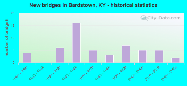
- New bridges - historical statistics
- 41930-1939
- 61950-1959
- 161960-1969
- 51970-1979
- 31980-1989
- 71990-1999
- 52000-2009
- 52010-2019
- 22020-2022


- Bridge Condition - Deck
- 16.7%Very good
- 61.1%Good
- 11.1%Satisfactory
- 5.6%Fair
- 5.6%Poor

- Bridge Condition - Superstructure
- 27.8%Very good
- 36.1%Good
- 19.4%Satisfactory
- 2.8%Fair
- 13.9%Poor

- Bridge Condition - Substructure
- 13.9%Very good
- 63.9%Good
- 22.2%Satisfactory

- Bridge Condition - Channel
- 15.8%Very good
- 73.7%Good
- 10.5%Satisfactory

- Bridge Condition - Culverts
- 44.4%Good
- 22.2%Satisfactory
- 22.2%Fair
- 11.1%Poor
Find on map >> Show street view
Structure Number: 90B00015L, Location: WBL 2.8 MI W OF US31E NTR (Lat: 37.779722, Lng: -85.538333), Route carried "on" structure: State highway 9002, Year Built: 1965, Status: Open, Structure Length: 14.17m (46.49ft), Average Daily Traffic: 6,749 (year 2019), Truck Traffic: 24%, Average Future Daily Traffic: 6,344 (year 2039), Design Load: H 20, Features Intersected: BEECH FORK RIVER, Facility Carried by Structure: MARTHA LAYNE COLLI
Minimum Vertical Clearance: 30+ m (98+ ft), Kilometerpoint: 28.287, Lanes on structure: 2, Base Highway Network: Yes, Owner: State Highway Agency, Approaching Roadway Width: 10.4m (34.1ft), Skew: 10 degrees, Material/Design: Concrete continuous, Design/Construction: Tee Beam, Number Of Spans In Main Unit: 3, Number Of Approach Spans: 4, Length of Maximum Span: 30.5m (100.1ft), Curb-To-Curb Width: 9.1m (29.9ft), Out-to-Out Width: 10.7m (35.1ft)
Condition: Deck: Good, Superstructure: Fair, Substructure: Good, Channel: Satisfactory, Operating Rating: 56.7 metric tons, Method Used To Determine Operating Rating: Load Factor (LF), Inventory Rating: 34.0 metric tons, Method Used To Determine Inventory Rating: Load Factor (LF), Structural Evaluation: Somewhat better than minimum adequacy, Deck Geometry: Meets minimum limits, Waterway Adequacy: Equal to present desirable criteria, Approach Roadway Alignment: Better than present minimum criteria, Designated Inspection Frequency: Every 24 months, Inspection Date: Febuary 2021, Deck Structure Type: Concrete Cast-file-Place, Wearing Surface/Protective System: Wearing Surface: Latex Concrete
Find on map >> Show street view
Structure Number: 90B00015R, Location: EBL 2.8 MI W OF US31E NTR (Lat: 37.779444, Lng: -85.538333), Route carried "on" structure: State highway 9002, Year Built: 1964, Status: Open, Structure Length: 14.17m (46.49ft), Average Daily Traffic: 6,749 (year 2019), Truck Traffic: 24%, Average Future Daily Traffic: 6,344 (year 2039), Design Load: H 20, Features Intersected: BEECH FORK RIVER
Minimum Vertical Clearance: 30+ m (98+ ft), Kilometerpoint: 28.304, Lanes on structure: 2, Base Highway Network: Yes, Owner: State Highway Agency, Approaching Roadway Width: 10.4m (34.1ft), Skew: 10 degrees, Material/Design: Concrete continuous, Design/Construction: Tee Beam, Number Of Spans In Main Unit: 3, Number Of Approach Spans: 4, Length of Maximum Span: 30.5m (100.1ft), Curb or Sidewalk Widths: Left: 0.5m (1.6ft), Right: 0.5m (1.6ft), Curb-To-Curb Width: 9.1m (29.9ft), Out-to-Out Width: 10.7m (35.1ft)
Condition: Deck: Good, Superstructure: Satisfactory, Substructure: Good, Channel: Satisfactory, Operating Rating: 56.7 metric tons, Method Used To Determine Operating Rating: Load Factor (LF), Inventory Rating: 34.0 metric tons, Method Used To Determine Inventory Rating: Load Factor (LF), Structural Evaluation: Equal to present minimum criteria, Deck Geometry: Meets minimum limits, Waterway Adequacy: Equal to present desirable criteria, Approach Roadway Alignment: Better than present minimum criteria, Designated Inspection Frequency: Every 24 months, Inspection Date: Febuary 2021, Deck Structure Type: Concrete Cast-file-Place, Wearing Surface/Protective System: Wearing Surface: Latex Concrete
Find on map >> Show street view
Structure Number: 90B00016L, Location: WBL 1 Mile E of US 31E (Lat: 37.777778, Lng: -85.471667), Route carried "on" structure: State highway 9002, Year Built: 1965, Status: Open, Structure Length: 14.45m (47.41ft), Average Daily Traffic: 5,480 (year 2020), Truck Traffic: 25%, Average Future Daily Traffic: 5,151 (year 2040), Design Load: H 20, Features Intersected: Beech Fork, Facility Carried by Structure: Bluegrass Parkway
Minimum Vertical Clearance: 30+ m (98+ ft), Kilometerpoint: 34.631, Lanes on structure: 2, Base Highway Network: Yes, Owner: State Highway Agency, Approaching Roadway Width: 11.3m (37.1ft), Skew: 13 degrees, Material/Design: Concrete continuous, Design/Construction: Tee Beam, Number Of Spans In Main Unit: 3, Number Of Approach Spans: 4, Length of Maximum Span: 30.5m (100.1ft), Curb-To-Curb Width: 9.1m (29.9ft), Out-to-Out Width: 10.7m (35.1ft)
Condition: Deck: Good, Superstructure: Satisfactory, Substructure: Satisfactory, Channel: Good, Operating Rating: 65.0 metric tons, Method Used To Determine Operating Rating: Load Factor (LF), Inventory Rating: 39.0 metric tons, Method Used To Determine Inventory Rating: Load Factor (LF), Structural Evaluation: Equal to present minimum criteria, Deck Geometry: Meets minimum limits, Waterway Adequacy: Equal to present desirable criteria, Approach Roadway Alignment: Equal to present desirable criteria, Designated Inspection Frequency: Every 24 months, Inspection Date: Febuary 2020, Deck Structure Type: Concrete Cast-file-Place, Wearing Surface/Protective System: Wearing Surface: Latex Concrete
Find on map >> Show street view
Structure Number: 90B00016R, Location: EBL 1 Mile E of US 31E (Lat: 37.777500, Lng: -85.471944), Route carried "on" structure: State highway 9002, Year Built: 1965, Status: Open, Structure Length: 14.45m (47.41ft), Average Daily Traffic: 5,480 (year 2020), Truck Traffic: 25%, Average Future Daily Traffic: 5,151 (year 2040), Design Load: H 20, Features Intersected: Beech Fork, Facility Carried by Structure: Bluegrass Parkway
Minimum Vertical Clearance: 30+ m (98+ ft), Kilometerpoint: 34.612, Lanes on structure: 2, Base Highway Network: Yes, Owner: State Highway Agency, Approaching Roadway Width: 10.4m (34.1ft), Skew: 13 degrees, Material/Design: Concrete continuous, Design/Construction: Tee Beam, Number Of Spans In Main Unit: 3, Number Of Approach Spans: 4, Length of Maximum Span: 30.5m (100.1ft), Curb or Sidewalk Widths: Left: 0.5m (1.6ft), Right: 0.5m (1.6ft), Curb-To-Curb Width: 9.1m (29.9ft), Out-to-Out Width: 10.7m (35.1ft)
Condition: Deck: Good, Superstructure: Satisfactory, Substructure: Satisfactory, Channel: Good, Operating Rating: 65.0 metric tons, Method Used To Determine Operating Rating: Load Factor (LF), Inventory Rating: 39.0 metric tons, Method Used To Determine Inventory Rating: Load Factor (LF), Structural Evaluation: Equal to present minimum criteria, Deck Geometry: Meets minimum limits, Waterway Adequacy: Equal to present desirable criteria, Approach Roadway Alignment: Equal to present desirable criteria, Designated Inspection Frequency: Every 24 months, Inspection Date: Febuary 2020, Deck Structure Type: Concrete Cast-file-Place, Wearing Surface/Protective System: Wearing Surface: Latex Concrete
Find on map >> Show street view
Structure Number: 90B00017L, Location: WBL .8 MI W OF US150 NTRC (Lat: 37.786944, Lng: -85.442778), Route carried "on" structure: State highway 9002, Year Built: 1965, Status: Open, Structure Length: 3.32m (10.89ft), Average Daily Traffic: 5,480 (year 2020), Truck Traffic: 25%, Average Future Daily Traffic: 5,151 (year 2040), Design Load: HS 20, Features Intersected: BARDSTOWN-LORETTO RD, Facility Carried by Structure: Bluegrass Parkway
Minimum Vertical Clearance: 30+ m (98+ ft), Kilometerpoint: 37.660, Lanes on structure: 2, Lanes under structure: 2, Base Highway Network: Yes, Owner: State Highway Agency, Approaching Roadway Width: 22.6m (74.1ft), Skew: 10 degrees, Material/Design: Concrete, Design/Construction: Tee Beam, Number Of Spans In Main Unit: 3, Length of Maximum Span: 12.2m (40.0ft), Curb-To-Curb Width: 11.6m (38.1ft), Out-to-Out Width: 12.0m (39.4ft)
Condition: Deck: Satisfactory, Superstructure: Good, Substructure: Good, Operating Rating: 62.9 metric tons, Method Used To Determine Operating Rating: Load Factor (LF), Inventory Rating: 37.7 metric tons, Method Used To Determine Inventory Rating: Load Factor (LF), Structural Evaluation: Better than present minimum criteria, Deck Geometry: Better than present minimum criteria, Underclear: Equal to present minimum criteria, Approach Roadway Alignment: Equal to present desirable criteria, Length Of Structure Improvement: 0.33m (1.08ft), Designated Inspection Frequency: Every 24 months, Inspection Date: Febuary 2021, Bridge Improvement Cost: $537,000, Total Project Cost: $536,000, Deck Structure Type: Concrete Cast-file-Place, Wearing Surface/Protective System: Wearing Surface: Latex Concrete
Find on map >> Show street view
Structure Number: 90B00017R, Location: EBL .8 MI W OF US150 NTRC (Lat: 37.786944, Lng: -85.442778), Route carried "on" structure: State highway 9002, Year Built: 1965, Status: Open, Structure Length: 3.32m (10.89ft), Average Daily Traffic: 5,480 (year 2020), Truck Traffic: 25%, Average Future Daily Traffic: 5,151 (year 2040), Design Load: HS 20, Features Intersected: BARDSTOWN-LORETTO RD, Facility Carried by Structure: Bluegrass Parkway
Minimum Vertical Clearance: 30+ m (98+ ft), Kilometerpoint: 37.675, Lanes on structure: 2, Lanes under structure: 2, Base Highway Network: Yes, Owner: State Highway Agency, Approaching Roadway Width: 22.6m (74.1ft), Skew: 10 degrees, Material/Design: Concrete, Design/Construction: Tee Beam, Number Of Spans In Main Unit: 3, Length of Maximum Span: 12.2m (40.0ft), Curb or Sidewalk Widths: Left: 0.2m (0.7ft), Right: 0.2m (0.7ft), Curb-To-Curb Width: 11.6m (38.1ft), Out-to-Out Width: 12.0m (39.4ft)
Condition: Deck: Good, Superstructure: Good, Substructure: Good, Operating Rating: 62.9 metric tons, Method Used To Determine Operating Rating: Load Factor (LF), Inventory Rating: 37.7 metric tons, Method Used To Determine Inventory Rating: Load Factor (LF), Structural Evaluation: Better than present minimum criteria, Deck Geometry: Better than present minimum criteria, Underclear: Equal to present minimum criteria, Approach Roadway Alignment: Equal to present desirable criteria, Length Of Structure Improvement: 0.33m (1.08ft), Designated Inspection Frequency: Every 24 months, Inspection Date: Febuary 2021, Bridge Improvement Cost: $537,000, Total Project Cost: $536,000, Deck Structure Type: Concrete Cast-file-Place, Wearing Surface/Protective System: Wearing Surface: Latex Concrete
Find on map >> Show street view
Structure Number: 90B00025N, Location: .80 MI WEST OF BG PW NTRC (Lat: 37.800278, Lng: -85.446111), Route carried "on" structure: US 150, Year Built: 1950, Status: Posted for load, Structure Length: 0.82m (2.69ft), Average Daily Traffic: 12,028 (year 2019), Truck Traffic: 10%, Average Future Daily Traffic: 11,186 (year 2039), Design Load: H 20, Features Intersected: ROWAN CREEK
Minimum Vertical Clearance: 30+ m (98+ ft), Kilometerpoint: 1.605, Lanes on structure: 2, Owner: State Highway Agency, Approaching Roadway Width: 21.3m (69.9ft), Material/Design: Concrete, Design/Construction: Culvert, Number Of Spans In Main Unit: 2, Length of Maximum Span: 3.7m (12.1ft)
Condition: Channel: Good, Culverts: Fair, Operating Rating: 39.0 metric tons, Method Used To Determine Operating Rating: Field evaluation and documented engineering judgment, Inventory Rating: 18.1 metric tons, Method Used To Determine Inventory Rating: Field evaluation and documented engineering judgment, Structural Evaluation: Meets minimum limits, Waterway Adequacy: Equal to present desirable criteria, Approach Roadway Alignment: Equal to present minimum criteria, Bridge Posting: Required (Relationship of Operating Rating to Maximum Legal Load: > 39.9% below), Designated Inspection Frequency: Every 24 months, Inspection Date: Febuary 2021
Find on map >> Show street view
Structure Number: 90B00026N, Location: 1.0 MI S.E. OF BG PW NTRC (Lat: 37.787778, Lng: -85.414444), Route carried "on" structure: US 150, Year Built: 1950, Status: Open, Structure Length: 0.82m (2.69ft), Average Daily Traffic: 13,854 (year 2019), Truck Traffic: 12%, Average Future Daily Traffic: 11,498 (year 2039), Design Load: H 20, Features Intersected: MILL CREEK
Minimum Vertical Clearance: 30+ m (98+ ft), Kilometerpoint: 4.986, Lanes on structure: 2, Base Highway Network: Yes, Owner: State Highway Agency, Approaching Roadway Width: 6.7m (22.0ft), Material/Design: Concrete, Design/Construction: Culvert, Number Of Spans In Main Unit: 2, Length of Maximum Span: 3.7m (12.1ft)
Condition: Channel: Good, Culverts: Fair, Operating Rating: 92.5 metric tons, Method Used To Determine Operating Rating: Allowable Stress (AS), Inventory Rating: 44.9 metric tons, Method Used To Determine Inventory Rating: Allowable Stress (AS), Structural Evaluation: Somewhat better than minimum adequacy, Waterway Adequacy: Equal to present desirable criteria, Approach Roadway Alignment: Equal to present desirable criteria, Designated Inspection Frequency: Every 24 months, Inspection Date: Febuary 2020
Find on map >> Show street view
Structure Number: 90B00029N, Location: 1 MI N OF JCT KY 2735 (Lat: 37.776667, Lng: -85.460278), Route carried "on" structure: State highway 49, Year Built: 1965, Status: Open, Structure Length: 6.58m (21.59ft), Average Daily Traffic: 3,370 (year 2019), Truck Traffic: 8%, Average Future Daily Traffic: 2,965 (year 2039), Design Load: H 20, Features Intersected: BLUEGRASS PARKWAY, Facility Carried by Structure: LEBANON ROAD
Minimum Vertical Clearance: 30+ m (98+ ft), Kilometerpoint: 11.256, Lanes on structure: 2, Lanes under structure: 4, Owner: State Highway Agency, Approaching Roadway Width: 6.7m (22.0ft), Skew: 20 degrees, Material/Design: Concrete, Design/Construction: Tee Beam, Number Of Spans In Main Unit: 4, Length of Maximum Span: 15.5m (50.9ft), Curb or Sidewalk Widths: Left: 0.5m (1.6ft), Right: 0.5m (1.6ft), Curb-To-Curb Width: 7.9m (25.9ft), Out-to-Out Width: 8.8m (28.9ft)
Condition: Deck: Good, Superstructure: Good, Substructure: Good, Operating Rating: 67.3 metric tons, Method Used To Determine Operating Rating: Load Factor (LF), Inventory Rating: 40.4 metric tons, Method Used To Determine Inventory Rating: Load Factor (LF), Structural Evaluation: Better than present minimum criteria, Deck Geometry: High priority of corrective action, Underclear: Meets minimum limits, Approach Roadway Alignment: Better than present minimum criteria, Designated Inspection Frequency: Every 24 months, Inspection Date: Febuary 2021, Deck Structure Type: Concrete Cast-file-Place, Wearing Surface/Protective System: Wearing Surface: Monolithic Concrete
Find on map >> Show street view
Structure Number: 90B00044N, Location: 1.9 MI SW OF JCT US 62 (Lat: 37.785556, Lng: -85.489167), Route carried "on" structure: US 31, Year Built: 1964, Status: Posted for load, Structure Length: 6.49m (21.29ft), Average Daily Traffic: 9,634 (year 2020), Truck Traffic: 8%, Average Future Daily Traffic: 8,959 (year 2040), Design Load: H 20, Features Intersected: BLUEGRASS PARKWAY
Minimum Vertical Clearance: 30+ m (98+ ft), Kilometerpoint: 19.236, Lanes on structure: 2, Lanes under structure: 4, Owner: State Highway Agency, Approaching Roadway Width: 7.3m (24.0ft), Material/Design: Concrete continuous, Design/Construction: Tee Beam, Number Of Spans In Main Unit: 3, Number Of Approach Spans: 1, Length of Maximum Span: 19.8m (65.0ft), Curb or Sidewalk Widths: Left: 0.5m (1.6ft), Right: 0.5m (1.6ft), Curb-To-Curb Width: 9.1m (29.9ft), Out-to-Out Width: 10.1m (33.1ft)
Condition: Deck: Good, Superstructure: Satisfactory, Substructure: Satisfactory, Operating Rating: 49.3 metric tons, Method Used To Determine Operating Rating: Load Factor (LF), Inventory Rating: 29.6 metric tons, Method Used To Determine Inventory Rating: Load Factor (LF), Structural Evaluation: Equal to present minimum criteria, Deck Geometry: Meets minimum limits, Underclear: Somewhat better than minimum adequacy, Approach Roadway Alignment: Equal to present minimum criteria, Bridge Posting: Required (Relationship of Operating Rating to Maximum Legal Load: 10.0 - 19.9% below), Designated Inspection Frequency: Every 24 months, Inspection Date: Febuary 2020, Deck Structure Type: Concrete Cast-file-Place, Wearing Surface/Protective System: Wearing Surface: Latex Concrete
Find on map >> Show street view
Structure Number: 90B00056N, Location: .8 MI W OF E-JCT KY 733 (Lat: 37.809167, Lng: -85.556667), Route carried "on" structure: US 62, Year Built: 1934, Status: Posted for load, Structure Length: 1.46m (4.79ft), Average Daily Traffic: 1,875 (year 2020), Truck Traffic: 16%, Average Future Daily Traffic: 1,650 (year 2040), Design Load: H 15, Features Intersected: CEDAR CREEK
Minimum Vertical Clearance: 30+ m (98+ ft), Kilometerpoint: 15.142, Lanes on structure: 2, Owner: State Highway Agency, Approaching Roadway Width: 7.3m (24.0ft), Skew: 4 degrees, Material/Design: Concrete, Design/Construction: Tee Beam, Number Of Spans In Main Unit: 1, Length of Maximum Span: 13.7m (44.9ft), Curb or Sidewalk Widths: Left: 0.1m (0.3ft), Right: 0.1m (0.3ft), Curb-To-Curb Width: 7.3m (24.0ft), Out-to-Out Width: 7.6m (24.9ft)
Condition: Deck: Poor, Superstructure: Poor, Substructure: Satisfactory, Channel: Good, Operating Rating: 47.9 metric tons, Method Used To Determine Operating Rating: Load Factor (LF), Inventory Rating: 28.8 metric tons, Method Used To Determine Inventory Rating: Load Factor (LF), Structural Evaluation: Meets minimum limits, Deck Geometry: Meets minimum limits, Waterway Adequacy: Equal to present desirable criteria, Approach Roadway Alignment: Better than present minimum criteria, Bridge Posting: Required (Relationship of Operating Rating to Maximum Legal Load: 20.0 - 29.9% below), Designated Inspection Frequency: Every 24 months, Inspection Date: Febuary 2020, Deck Structure Type: Concrete Cast-file-Place, Wearing Surface/Protective System: Wearing Surface: Bituminous
Find on map >> Show street view
Structure Number: 90B00063N, Location: .65 MI S.E. OF JCT KY 245 (Lat: 37.829722, Lng: -85.485000), Route carried "on" structure: State highway 1430, Year Built: 1934, Status: Open, Structure Length: 0.82m (2.69ft), Average Daily Traffic: 5,148 (year 2019), Truck Traffic: 8%, Average Future Daily Traffic: 4,787 (year 2039), Features Intersected: ITHROW CREEK
Minimum Vertical Clearance: 30+ m (98+ ft), Kilometerpoint: 2.578, Lanes on structure: 2, Owner: State Highway Agency, Approaching Roadway Width: 6.7m (22.0ft), Skew: 3 degrees, Material/Design: Concrete, Design/Construction: Culvert, Number Of Spans In Main Unit: 2, Length of Maximum Span: 3.7m (12.1ft)
Condition: Channel: Good, Culverts: Good, Operating Rating: 54.4 metric tons, Method Used To Determine Operating Rating: Field evaluation and documented engineering judgment, Inventory Rating: 39.9 metric tons, Method Used To Determine Inventory Rating: Field evaluation and documented engineering judgment, Structural Evaluation: Better than present minimum criteria, Waterway Adequacy: Equal to present minimum criteria, Approach Roadway Alignment: Better than present minimum criteria, Designated Inspection Frequency: Every 24 months, Inspection Date: Febuary 2021
Find on map >> Show street view
Structure Number: 90B00069N, Location: .80 MI EAST OF JCT US 31E (Lat: 37.903611, Lng: -85.458056), Route carried "on" structure: State highway 509, Year Built: 1954, Status: Open, Structure Length: 1.04m (3.41ft), Average Daily Traffic: 820 (year 2020), Average Future Daily Traffic: 721 (year 2040), Design Load: H 15, Features Intersected: BR OF COX CREEK
Minimum Vertical Clearance: 30+ m (98+ ft), Kilometerpoint: 8.774, Lanes on structure: 2, Owner: State Highway Agency, Approaching Roadway Width: 6.7m (22.0ft), Material/Design: Concrete, Design/Construction: Culvert, Number Of Spans In Main Unit: 3, Length of Maximum Span: 3.0m (9.8ft)
Condition: Channel: Good, Culverts: Good, Operating Rating: 54.4 metric tons, Method Used To Determine Operating Rating: Field evaluation and documented engineering judgment, Inventory Rating: 39.9 metric tons, Method Used To Determine Inventory Rating: Field evaluation and documented engineering judgment, Structural Evaluation: Better than present minimum criteria, Waterway Adequacy: Equal to present minimum criteria, Approach Roadway Alignment: Equal to present minimum criteria, Length Of Structure Improvement: 0.10m (0.33ft), Designated Inspection Frequency: Every 24 months, Inspection Date: Febuary 2021, Bridge Improvement Cost: $102,000, Total Project Cost: $102,000
Find on map >> Show street view
Structure Number: 90B00070N, Location: .35 MI EAST OF JCT US 31E (Lat: 37.901944, Lng: -85.465000), Route carried "on" structure: State highway 509, Year Built: 1972, Status: Posted for load, Structure Length: 1.95m (6.40ft), Average Daily Traffic: 820 (year 2020), Average Future Daily Traffic: 721 (year 2040), Design Load: HS 20, Features Intersected: COX CREEK
Minimum Vertical Clearance: 30+ m (98+ ft), Kilometerpoint: 8.121, Lanes on structure: 2, Owner: State Highway Agency, Approaching Roadway Width: 7.3m (24.0ft), Material/Design: Prestressed concrete, Design/Construction: Box Beam or Girders - Multiple, Number Of Spans In Main Unit: 1, Length of Maximum Span: 18.3m (60.0ft), Curb or Sidewalk Widths: Left: 0.2m (0.7ft), Right: 0.2m (0.7ft), Curb-To-Curb Width: 7.9m (25.9ft), Out-to-Out Width: 8.3m (27.2ft)
Condition: Deck: Poor, Superstructure: Poor, Substructure: Good, Channel: Good, Operating Rating: 27.1 metric tons, Method Used To Determine Operating Rating: Load Factor (LF), Inventory Rating: 16.2 metric tons, Method Used To Determine Inventory Rating: Load Factor (LF), Structural Evaluation: Meets minimum limits, Deck Geometry: Somewhat better than minimum adequacy, Waterway Adequacy: Better than present minimum criteria, Approach Roadway Alignment: Somewhat better than minimum adequacy, Bridge Posting: Required (Relationship of Operating Rating to Maximum Legal Load: > 39.9% below), Designated Inspection Frequency: Every 24 months, Inspection Date: Febuary 2020, Deck Structure Type: Concrete Cast-file-Place, Wearing Surface/Protective System: Wearing Surface: Monolithic Concrete
Find on map >> Show street view
Structure Number: 90B00081N, Location: 1.2 M NE OF BG PW OP-B80 (Lat: 37.775556, Lng: -85.547500), Route carried "on" structure: State highway 733, Year Built: 1952, Status: Open, Structure Length: 1.22m (4.00ft), Average Daily Traffic: 407 (year 2020), Average Future Daily Traffic: 354 (year 2040), Design Load: H 15, Features Intersected: CEDAR CREEK
Minimum Vertical Clearance: 30+ m (98+ ft), Kilometerpoint: 17.770, Lanes on structure: 2, Owner: State Highway Agency, Approaching Roadway Width: 6.1m (20.0ft), Material/Design: Concrete, Design/Construction: Culvert, Number Of Spans In Main Unit: 3, Length of Maximum Span: 3.7m (12.1ft), Out-to-Out Width: 7.0m (23.0ft)
Condition: Channel: Good, Culverts: Good, Operating Rating: 54.4 metric tons, Method Used To Determine Operating Rating: Field evaluation and documented engineering judgment, Inventory Rating: 39.9 metric tons, Method Used To Determine Inventory Rating: Field evaluation and documented engineering judgment, Structural Evaluation: Better than present minimum criteria, Waterway Adequacy: Equal to present desirable criteria, Approach Roadway Alignment: Better than present minimum criteria, Designated Inspection Frequency: Every 24 months, Inspection Date: Febuary 2021
Find on map >> Show street view
Structure Number: 90B00086N, Location: 1.5 MI SE OF JCT US 62 (Lat: 37.818611, Lng: -85.397222), Route carried "on" structure: State highway 605, Year Built: 1964, Status: Posted for load, Structure Length: 6.77m (22.21ft), Average Daily Traffic: 2,240 (year 2019), Average Future Daily Traffic: 2,083 (year 2039), Design Load: H 20, Features Intersected: BLUEGRASS PARKWAY
Minimum Vertical Clearance: 30+ m (98+ ft), Kilometerpoint: 14.375, Lanes on structure: 2, Lanes under structure: 4, Owner: State Highway Agency, Approaching Roadway Width: 5.5m (18.0ft), Skew: 23 degrees, Material/Design: Concrete continuous, Design/Construction: Tee Beam, Number Of Spans In Main Unit: 4, Length of Maximum Span: 20.1m (65.9ft), Curb or Sidewalk Widths: Left: 0.5m (1.6ft), Right: 0.5m (1.6ft), Curb-To-Curb Width: 7.9m (25.9ft), Out-to-Out Width: 8.8m (28.9ft)
Condition: Deck: Fair, Superstructure: Good, Substructure: Good, Operating Rating: 39.0 metric tons, Method Used To Determine Operating Rating: Load Factor (LF), Inventory Rating: 23.4 metric tons, Method Used To Determine Inventory Rating: Load Factor (LF), Structural Evaluation: Equal to present minimum criteria, Deck Geometry: High priority of corrective action, Underclear: Meets minimum limits, Approach Roadway Alignment: Equal to present minimum criteria, Bridge Posting: Required (Relationship of Operating Rating to Maximum Legal Load: 30.0 - 39.9% below), Designated Inspection Frequency: Every 24 months, Inspection Date: Febuary 2020, Deck Structure Type: Concrete Cast-file-Place, Wearing Surface/Protective System: Wearing Surface: Latex Concrete, Deck Protection: Epoxy Coated Reinforcing
Find on map >> Show street view
Structure Number: 90B00087N, Location: .85 MI SE OF JCT US 62 (Lat: 37.822778, Lng: -85.408333), Route carried "on" structure: State highway 605, Year Built: 1956, Status: Posted for load, Structure Length: 0.79m (2.59ft), Average Daily Traffic: 5,462 (year 2019), Truck Traffic: 8%, Average Future Daily Traffic: 5,079 (year 2039), Design Load: H 15, Features Intersected: ROWAN CREEK
Minimum Vertical Clearance: 30+ m (98+ ft), Kilometerpoint: 15.538, Lanes on structure: 2, Owner: State Highway Agency, Approaching Roadway Width: 11.9m (39.0ft), Skew: 4 degrees, Material/Design: Concrete, Design/Construction: Culvert, Number Of Spans In Main Unit: 2, Length of Maximum Span: 3.4m (11.2ft)
Condition: Channel: Good, Culverts: Satisfactory, Operating Rating: 20.0 metric tons, Method Used To Determine Operating Rating: Field evaluation and documented engineering judgment, Inventory Rating: 20.0 metric tons, Method Used To Determine Inventory Rating: Field evaluation and documented engineering judgment, Structural Evaluation: Somewhat better than minimum adequacy, Waterway Adequacy: Equal to present minimum criteria, Approach Roadway Alignment: Equal to present minimum criteria, Bridge Posting: Required (Relationship of Operating Rating to Maximum Legal Load: > 39.9% below), Designated Inspection Frequency: Every 24 months, Inspection Date: Febuary 2021
Find on map >> Show street view
Structure Number: 90B00088N, Location: 1.6 MI S.E. OF BG PW OP (Lat: 37.814167, Lng: -85.375278), Route carried "on" structure: State highway 605, Year Built: 1956, Status: Posted for load, Structure Length: 0.98m (3.22ft), Average Daily Traffic: 2,240 (year 2019), Average Future Daily Traffic: 2,083 (year 2039), Design Load: H 15, Features Intersected: MILL CREEK
Minimum Vertical Clearance: 30+ m (98+ ft), Kilometerpoint: 11.669, Lanes on structure: 2, Owner: State Highway Agency, Approaching Roadway Width: 5.5m (18.0ft), Skew: 4 degrees, Material/Design: Concrete, Design/Construction: Culvert, Number Of Spans In Main Unit: 2, Length of Maximum Span: 4.3m (14.1ft), Curb-To-Curb Width: 5.5m (18.0ft), Out-to-Out Width: 6.7m (22.0ft)
Condition: Channel: Satisfactory, Culverts: Satisfactory, Operating Rating: 20.0 metric tons, Method Used To Determine Operating Rating: Field evaluation and documented engineering judgment, Inventory Rating: 20.0 metric tons, Method Used To Determine Inventory Rating: Field evaluation and documented engineering judgment, Structural Evaluation: Somewhat better than minimum adequacy, Deck Geometry: High priority of replacement, Waterway Adequacy: Better than present minimum criteria, Approach Roadway Alignment: Equal to present minimum criteria, Bridge Posting: Required (Relationship of Operating Rating to Maximum Legal Load: > 39.9% below), Designated Inspection Frequency: Every 24 months, Inspection Date: Febuary 2020
Find on map >> Show street view
Structure Number: 90B00093N, Location: .6 MI S OF JCT US 62 (Lat: 37.838889, Lng: -85.369167), Route carried "on" structure: State highway 1858, Year Built: 1965, Status: Open, Structure Length: 5.97m (19.59ft), Average Daily Traffic: 554 (year 2019), Average Future Daily Traffic: 487 (year 2039), Design Load: H 20, Features Intersected: BLUEGRASS PARKWAY
Minimum Vertical Clearance: 30+ m (98+ ft), Kilometerpoint: 0.723, Lanes on structure: 2, Lanes under structure: 4, Owner: State Highway Agency, Approaching Roadway Width: 5.5m (18.0ft), Skew: 20 degrees, Material/Design: Concrete, Design/Construction: Tee Beam, Number Of Spans In Main Unit: 4, Length of Maximum Span: 15.8m (51.8ft), Curb or Sidewalk Widths: Left: 0.5m (1.6ft), Right: 0.5m (1.6ft), Curb-To-Curb Width: 7.9m (25.9ft), Out-to-Out Width: 8.8m (28.9ft)
Condition: Deck: Fair, Superstructure: Satisfactory, Substructure: Satisfactory, Operating Rating: 58.3 metric tons, Method Used To Determine Operating Rating: Load Factor (LF), Inventory Rating: 35.0 metric tons, Method Used To Determine Inventory Rating: Load Factor (LF), Structural Evaluation: Equal to present minimum criteria, Deck Geometry: Somewhat better than minimum adequacy, Underclear: Somewhat better than minimum adequacy, Approach Roadway Alignment: Equal to present minimum criteria, Designated Inspection Frequency: Every 24 months, Inspection Date: Febuary 2021, Deck Structure Type: Concrete Cast-file-Place, Wearing Surface/Protective System: Wearing Surface: Monolithic Concrete, Deck Protection: Epoxy Coated Reinforcing
Find on map >> Show street view
Structure Number: 90B00101N, Location: 2.4 MI S.W. OF JCT US 31E (Lat: 37.883611, Lng: -85.504444), Route carried "on" structure: State highway 509, Year Built: 1980, Status: Open, Structure Length: 2.07m (6.79ft), Average Daily Traffic: 1,154 (year 2019), Average Future Daily Traffic: 1,015 (year 2039), Design Load: HS 20, Features Intersected: SAMUELS CREEK
Minimum Vertical Clearance: 30+ m (98+ ft), Kilometerpoint: 3.589, Lanes on structure: 2, Owner: State Highway Agency, Approaching Roadway Width: 6.7m (22.0ft), Skew: 4 degrees, Material/Design: Prestressed concrete, Design/Construction: Box Beam or Girders - Multiple, Number Of Spans In Main Unit: 1, Length of Maximum Span: 19.8m (65.0ft), Curb-To-Curb Width: 7.9m (25.9ft), Out-to-Out Width: 8.4m (27.6ft)
Condition: Deck: Good, Superstructure: Poor, Substructure: Good, Channel: Good, Operating Rating: 57.9 metric tons, Method Used To Determine Operating Rating: Load Factor (LF), Inventory Rating: 34.7 metric tons, Method Used To Determine Inventory Rating: Load Factor (LF), Structural Evaluation: Meets minimum limits, Deck Geometry: Meets minimum limits, Waterway Adequacy: Equal to present minimum criteria, Approach Roadway Alignment: Better than present minimum criteria, Designated Inspection Frequency: Every 24 months, Inspection Date: Febuary 2021, Deck Structure Type: Concrete Precast Panels, Wearing Surface/Protective System: Wearing Surface: Bituminous
Find on map >> Show street view
Structure Number: 90B00103N, Location: 2.1 MI W OF W-JCT US 31E (Lat: 37.806389, Lng: -85.508611), Route carried "on" structure: US 62, Year Built: 1980, Status: Open, Structure Length: 1.74m (5.71ft), Average Daily Traffic: 4,793 (year 2018), Truck Traffic: 10%, Average Future Daily Traffic: 4,217 (year 2038), Design Load: HS 20, Features Intersected: SYMPSON LAKE SPILLWAY
Minimum Vertical Clearance: 30+ m (98+ ft), Kilometerpoint: 19.496, Lanes on structure: 2, Owner: State Highway Agency, Approaching Roadway Width: 13.4m (44.0ft), Material/Design: Prestressed concrete, Design/Construction: Stringer/Multi-beam, Number Of Spans In Main Unit: 1, Length of Maximum Span: 17.4m (57.1ft), Curb-To-Curb Width: 13.9m (45.6ft), Out-to-Out Width: 14.4m (47.2ft)
Condition: Deck: Good, Superstructure: Very good, Substructure: Satisfactory, Channel: Very good, Operating Rating: 98.7 metric tons, Method Used To Determine Operating Rating: Load Factor (LF), Inventory Rating: 59.2 metric tons, Method Used To Determine Inventory Rating: Load Factor (LF), Structural Evaluation: Equal to present minimum criteria, Deck Geometry: Superior to present desirable criteria, Waterway Adequacy: Equal to present desirable criteria, Approach Roadway Alignment: Equal to present desirable criteria, Designated Inspection Frequency: Every 24 months, Inspection Date: Febuary 2021, Deck Structure Type: Concrete Cast-file-Place, Wearing Surface/Protective System: Wearing Surface: Monolithic Concrete
Find on map >> Show street view
Structure Number: 90B00107N, Location: 1.6 MI W OF JCT KY 1430 (Lat: 37.826944, Lng: -85.511944), Route carried "on" structure: State highway 2737, Year Built: 1976, Status: Posted for load, Structure Length: 1.04m (3.41ft), Average Daily Traffic: 838 (year 2018), Average Future Daily Traffic: 729 (year 2038), Design Load: H 15, Features Intersected: BUFFALO CREEK
Minimum Vertical Clearance: 30+ m (98+ ft), Kilometerpoint: 3.550, Lanes on structure: 2, Owner: State Highway Agency, Approaching Roadway Width: 5.5m (18.0ft), Material/Design: Concrete, Design/Construction: Channel Beam, Number Of Spans In Main Unit: 1, Length of Maximum Span: 9.8m (32.2ft), Curb-To-Curb Width: 5.9m (19.4ft), Out-to-Out Width: 6.5m (21.3ft)
Condition: Deck: Satisfactory, Superstructure: Poor, Substructure: Satisfactory, Channel: Good, Operating Rating: 28.9 metric tons, Method Used To Determine Operating Rating: Load Factor (LF), Inventory Rating: 17.4 metric tons, Method Used To Determine Inventory Rating: Load Factor (LF), Structural Evaluation: Meets minimum limits, Deck Geometry: High priority of replacement, Waterway Adequacy: Better than present minimum criteria, Approach Roadway Alignment: Equal to present minimum criteria, Bridge Posting: Required (Relationship of Operating Rating to Maximum Legal Load: > 39.9% below), Designated Inspection Frequency: Every 12 months, Inspection Date: Febuary 2021, Deck Structure Type: Concrete Precast Panels, Wearing Surface/Protective System: Wearing Surface: Bituminous
Find on map >> Show street view
Structure Number: 90B00108N, Location: 1.9 MI NW OF JCT KY 509 (Lat: 37.916667, Lng: -85.497778), Route carried "on" structure: State highway 2739, Year Built: 1979, Status: Open, Structure Length: 3.17m (10.40ft), Average Daily Traffic: 153 (year 2019), Average Future Daily Traffic: 133 (year 2039), Design Load: HS 20, Features Intersected: COX CREEK
Minimum Vertical Clearance: 30+ m (98+ ft), Kilometerpoint: 3.264, Lanes on structure: 2, Owner: State Highway Agency, Approaching Roadway Width: 5.5m (18.0ft), Material/Design: Prestressed concrete, Design/Construction: Box Beam or Girders - Multiple, Number Of Spans In Main Unit: 2, Length of Maximum Span: 15.8m (51.8ft), Curb or Sidewalk Widths: Left: 0.3m (1.0ft), Right: 0.3m (1.0ft), Curb-To-Curb Width: 7.0m (23.0ft), Out-to-Out Width: 7.4m (24.3ft)
Condition: Deck: Good, Superstructure: Satisfactory, Substructure: Good, Channel: Satisfactory, Operating Rating: 77.4 metric tons, Method Used To Determine Operating Rating: Load Factor (LF), Inventory Rating: 46.4 metric tons, Method Used To Determine Inventory Rating: Load Factor (LF), Structural Evaluation: Equal to present minimum criteria, Deck Geometry: Meets minimum limits, Waterway Adequacy: Equal to present minimum criteria, Approach Roadway Alignment: Meets minimum limits, Designated Inspection Frequency: Every 24 months, Inspection Date: Febuary 2020, Deck Structure Type: Concrete Cast-file-Place, Wearing Surface/Protective System: Wearing Surface: Monolithic Concrete
Find on map >> Show street view
Structure Number: 90B00111N, Location: 1.0 MI S BG PKWAY OP (Lat: 37.760556, Lng: -85.460278), Route carried "on" structure: State highway 49, Year Built: 1991, Status: Open, Structure Length: 13.53m (44.39ft), Average Daily Traffic: 3,370 (year 2019), Truck Traffic: 8%, Average Future Daily Traffic: 2,965 (year 2039), Design Load: HS 25 or greater, Features Intersected: BEECH FORK @ GREENWELL F
Minimum Vertical Clearance: 30+ m (98+ ft), Kilometerpoint: 9.363, Lanes on structure: 2, Owner: State Highway Agency, Approaching Roadway Width: 11.0m (36.1ft), Material/Design: Prestressed concrete continuous, Design/Construction: Stringer/Multi-beam, Number Of Spans In Main Unit: 4, Length of Maximum Span: 33.5m (109.9ft), Curb-To-Curb Width: 9.3m (30.5ft), Out-to-Out Width: 10.3m (33.8ft)
Condition: Deck: Very good, Superstructure: Very good, Substructure: Very good, Channel: Good, Operating Rating: 99.8 metric tons, Method Used To Determine Operating Rating: Load Factor (LF), Inventory Rating: 62.4 metric tons, Method Used To Determine Inventory Rating: Load Factor (LF), Structural Evaluation: Equal to present desirable criteria, Deck Geometry: Meets minimum limits, Waterway Adequacy: Equal to present minimum criteria, Approach Roadway Alignment: Equal to present minimum criteria, Designated Inspection Frequency: Every 24 months, Inspection Date: Febuary 2021, Deck Structure Type: Concrete Cast-file-Place, Wearing Surface/Protective System: Wearing Surface: Monolithic Concrete, Deck Protection: Epoxy Coated Reinforcing
Find on map >> Show street view
Structure Number: 90B00113N, Location: .35 MI.S.S.CL.BARDSTOWN (Lat: 37.796667, Lng: -85.480556), Route carried "on" structure: US 31, Year Built: 2000, Status: Open, Structure Length: 14.39m (47.21ft), Average Daily Traffic: 9,634 (year 2020), Truck Traffic: 8%, Average Future Daily Traffic: 8,959 (year 2040), Design Load: HS 25 or greater, Features Intersected: BEECH FORK RIVER
Minimum Vertical Clearance: 30+ m (98+ ft), Kilometerpoint: 20.704, Lanes on structure: 2, Owner: State Highway Agency, Approaching Roadway Width: 14.3m (46.9ft), Material/Design: Prestressed concrete continuous, Design/Construction: Stringer/Multi-beam, Number Of Spans In Main Unit: 5, Length of Maximum Span: 42.7m (140.1ft), Curb-To-Curb Width: 13.2m (43.3ft), Out-to-Out Width: 14.2m (46.6ft)
Condition: Deck: Satisfactory, Superstructure: Very good, Substructure: Good, Channel: Good, Operating Rating: 73.1 metric tons, Method Used To Determine Operating Rating: Load Factor (LF), Inventory Rating: 43.8 metric tons, Method Used To Determine Inventory Rating: Load Factor (LF), Structural Evaluation: Better than present minimum criteria, Deck Geometry: Somewhat better than minimum adequacy, Waterway Adequacy: Equal to present desirable criteria, Approach Roadway Alignment: Better than present minimum criteria, Designated Inspection Frequency: Every 24 months, Inspection Date: Febuary 2021, Deck Structure Type: Concrete Cast-file-Place, Wearing Surface/Protective System: Wearing Surface: Monolithic Concrete, Deck Protection: Epoxy Coated Reinforcing
Find on map >> Show street view
Structure Number: 90B00114N, Location: 1.7 Miles South of US 150 (Lat: 37.786667, Lng: -85.465833), Route carried "on" structure: State highway 49, Year Built: 2003, Status: Open, Structure Length: 2.62m (8.60ft), Average Daily Traffic: 3,370 (year 2019), Truck Traffic: 8%, Average Future Daily Traffic: 2,965 (year 2039), Design Load: HS 25 or greater, Features Intersected: ROWAN CREEK
Minimum Vertical Clearance: 30+ m (98+ ft), Kilometerpoint: 12.558, Lanes on structure: 2, Owner: State Highway Agency, Approaching Roadway Width: 8.8m (28.9ft), Material/Design: Prestressed concrete continuous, Design/Construction: Box Beam or Girders - Single/Spread, Number Of Spans In Main Unit: 2, Length of Maximum Span: 12.8m (42.0ft), Curb-To-Curb Width: 9.8m (32.2ft), Out-to-Out Width: 10.7m (35.1ft)
Condition: Deck: Very good, Superstructure: Very good, Substructure: Good, Channel: Very good, Operating Rating: 99.8 metric tons, Method Used To Determine Operating Rating: Load Factor (LF), Inventory Rating: 62.4 metric tons, Method Used To Determine Inventory Rating: Load Factor (LF), Structural Evaluation: Better than present minimum criteria, Deck Geometry: Meets minimum limits, Waterway Adequacy: Equal to present desirable criteria, Approach Roadway Alignment: Equal to present desirable criteria, Designated Inspection Frequency: Every 24 months, Inspection Date: Febuary 2020, Deck Structure Type: Concrete Cast-file-Place, Wearing Surface/Protective System: Wearing Surface: Monolithic Concrete, Deck Protection: Epoxy Coated Reinforcing
Find on map >> Show street view
Structure Number: 90B00115N, Location: 0.7 MI W JCT US 31E (Lat: 37.811111, Lng: -85.486667), Route carried "on" structure: US 62, Year Built: 2006, Status: Open, Structure Length: 21.21m (69.59ft), Average Daily Traffic: 4,793 (year 2018), Truck Traffic: 10%, Average Future Daily Traffic: 4,457 (year 2038), Design Load: HS 25 or greater, Features Intersected: WITHROW CREEK
Minimum Vertical Clearance: 30+ m (98+ ft), Kilometerpoint: 21.602, Lanes on structure: 2, Owner: State Highway Agency, Approaching Roadway Width: 14.6m (47.9ft), Material/Design: Prestressed concrete continuous, Design/Construction: Stringer/Multi-beam, Number Of Spans In Main Unit: 5, Length of Maximum Span: 42.7m (140.1ft), Curb-To-Curb Width: 14.6m (47.9ft), Out-to-Out Width: 15.5m (50.9ft)
Condition: Deck: Good, Superstructure: Good, Substructure: Good, Channel: Good, Operating Rating: 86.4 metric tons, Method Used To Determine Operating Rating: Load Factor (LF), Inventory Rating: 51.8 metric tons, Method Used To Determine Inventory Rating: Load Factor (LF), Structural Evaluation: Better than present minimum criteria, Deck Geometry: Superior to present desirable criteria, Waterway Adequacy: Superior to present desirable criteria, Approach Roadway Alignment: Equal to present desirable criteria, Designated Inspection Frequency: Every 24 months, Inspection Date: Febuary 2021, Deck Structure Type: Concrete Cast-file-Place, Wearing Surface/Protective System: Wearing Surface: Monolithic Concrete, Deck Protection: Epoxy Coated Reinforcing
Find on map >> Show street view
Structure Number: 90B00122N, Location: 1.5 Mi SE Jct KY 49 (Lat: 37.797500, Lng: -85.429722), Route carried "on" structure: US 150, Year Built: 2018, Status: Open, Structure Length: 7.01m (23.00ft), Average Daily Traffic: 16,788 (year 2020), Truck Traffic: 14%, Average Future Daily Traffic: 15,612 (year 2040), Design Load: Greater than HL93, Features Intersected: Bluegrass Parkway
Minimum Vertical Clearance: 30+ m (98+ ft), Kilometerpoint: 3.137, Lanes on structure: 3, Lanes under structure: 4, Owner: State Highway Agency, Approaching Roadway Width: 25.0m (82.0ft), Skew: 2 degrees, Material/Design: Prestressed concrete, Design/Construction: Box Beam or Girders - Single/Spread, Number Of Spans In Main Unit: 4, Length of Maximum Span: 18.3m (60.0ft), Curb-To-Curb Width: 25.0m (82.0ft), Out-to-Out Width: 25.9m (85.0ft)
Condition: Deck: Very good, Superstructure: Very good, Substructure: Very good, Operating Rating: 68.4 metric tons, Method Used To Determine Operating Rating: Load and Resistance Factor Rating (LRFR) rating reported by rating factor(RF) method using HL-93 loadings, Inventory Rating: 52.5 metric tons, Method Used To Determine Inventory Rating: Load and Resistance Factor Rating (LRFR) rating reported by rating factor(RF) method using HL-93 loadings, Structural Evaluation: Equal to present desirable criteria, Deck Geometry: Superior to present desirable criteria, Underclear: Somewhat better than minimum adequacy, Approach Roadway Alignment: Equal to present desirable criteria, Designated Inspection Frequency: Every 24 months, Inspection Date: Febuary 2020, Deck Structure Type: Concrete Cast-file-Place, Wearing Surface/Protective System: Wearing Surface: Monolithic Concrete, Deck Protection: Epoxy Coated Reinforcing
Find on map >> Show street view
Structure Number: 90B00123N, Location: 0.85 MI W OF JCT US 31E (Lat: 37.899722, Lng: -85.490278), Route carried "on" structure: State highway 509, Year Built: 2020, Status: Open, Structure Length: 2.01m (6.59ft), Average Daily Traffic: 1,154 (year 2019), Average Future Daily Traffic: 1,015 (year 2039), Design Load: Greater than HL93, Features Intersected: Froman Creek
Minimum Vertical Clearance: 30+ m (98+ ft), Kilometerpoint: 5.824, Lanes on structure: 2, Owner: State Highway Agency, Approaching Roadway Width: 6.7m (22.0ft), Skew: 1 degrees, Material/Design: Prestressed concrete, Design/Construction: Box Beam or Girders - Multiple, Number Of Spans In Main Unit: 1, Length of Maximum Span: 19.5m (64.0ft), Curb-To-Curb Width: 6.9m (22.6ft), Out-to-Out Width: 7.3m (24.0ft)
Condition: Deck: Very good, Superstructure: Very good, Substructure: Good, Channel: Very good, Operating Rating: 71.3 metric tons, Method Used To Determine Operating Rating: Load and Resistance Factor Rating (LRFR) rating reported by rating factor(RF) method using HL-93 loadings, Inventory Rating: 55.1 metric tons, Method Used To Determine Inventory Rating: Load and Resistance Factor Rating (LRFR) rating reported by rating factor(RF) method using HL-93 loadings, Structural Evaluation: Better than present minimum criteria, Deck Geometry: High priority of corrective action, Waterway Adequacy: Equal to present desirable criteria, Approach Roadway Alignment: Somewhat better than minimum adequacy, Designated Inspection Frequency: Every 24 months, Inspection Date: Febuary 2021, Deck Structure Type: Concrete Cast-file-Place, Wearing Surface/Protective System: Wearing Surface: Monolithic Concrete, Deck Protection: Epoxy Coated Reinforcing
Find on map >> Show street view
Structure Number: 90C00002N, Location: 1.8 MI. E OF JCT KY 605 (Lat: 37.805833, Lng: -85.348056), Route carried "on" structure: County highway 1012, Year Built: 1974, Status: Posted for load, Structure Length: 0.76m (2.49ft), Average Daily Traffic: 133 (year 2006), Average Future Daily Traffic: 199 (year 2026), Features Intersected: DRY RUN CREEK, Facility Carried by Structure: WOODLAWN RD
Minimum Vertical Clearance: 30+ m (98+ ft), Kilometerpoint: 2.655, Lanes on structure: 2, Owner: County Highway Agency, Approaching Roadway Width: 4.6m (15.1ft), Skew: 3 degrees, Material/Design: Concrete, Design/Construction: Culvert, Number Of Spans In Main Unit: 1, Length of Maximum Span: 7.3m (24.0ft), Curb-To-Curb Width: 7.8m (25.6ft), Out-to-Out Width: 8.0m (26.2ft)
Condition: Channel: Good, Culverts: Poor, Operating Rating: 16.3 metric tons, Method Used To Determine Operating Rating: Field evaluation and documented engineering judgment, Inventory Rating: 16.3 metric tons, Method Used To Determine Inventory Rating: Field evaluation and documented engineering judgment, Structural Evaluation: Meets minimum limits, Deck Geometry: Somewhat better than minimum adequacy, Waterway Adequacy: Equal to present minimum criteria, Approach Roadway Alignment: Meets minimum limits, Bridge Posting: Required (Relationship of Operating Rating to Maximum Legal Load: > 39.9% below), Designated Inspection Frequency: Every 24 months, Inspection Date: July 2020
Find on map >> Show street view
Structure Number: 90C00042N, Location: 50' East of KY 509 (Lat: 37.881667, Lng: -85.506944), Route carried "on" structure: County highway 1309, Year Built: 1979, Status: Open, Structure Length: 0.98m (3.22ft), Average Daily Traffic: 277 (year 2010), Average Future Daily Traffic: 240 (year 2030), Design Load: HS 20, Features Intersected: SAMUELS CREEK, Facility Carried by Structure: SULLIVAN LN
Minimum Vertical Clearance: 30+ m (98+ ft), Kilometerpoint: 0.023, Lanes on structure: 2, Owner: County Highway Agency, Approaching Roadway Width: 6.7m (22.0ft), Material/Design: Prestressed concrete, Design/Construction: Box Beam or Girders - Multiple, Number Of Spans In Main Unit: 1, Length of Maximum Span: 8.8m (28.9ft), Curb-To-Curb Width: 6.9m (22.6ft), Out-to-Out Width: 7.4m (24.3ft)
Condition: Deck: Good, Superstructure: Poor, Substructure: Good, Channel: Good, Operating Rating: 94.3 metric tons, Method Used To Determine Operating Rating: Load Factor (LF), Inventory Rating: 56.6 metric tons, Method Used To Determine Inventory Rating: Load Factor (LF), Structural Evaluation: Meets minimum limits, Deck Geometry: Meets minimum limits, Waterway Adequacy: Equal to present desirable criteria, Approach Roadway Alignment: Equal to present minimum criteria, Designated Inspection Frequency: Every 24 months, Inspection Date: July 2020, Deck Structure Type: Concrete Precast Panels, Wearing Surface/Protective System: Wearing Surface: Monolithic Concrete, Deck Protection: Epoxy Coated Reinforcing
Find on map >> Show street view
Structure Number: 90C00044N, Location: 2.3 MI E of CR 5063 (Lat: 37.875000, Lng: -85.416944), Route carried "on" structure: County highway 1062, Year Built: 1980, Status: Open, Structure Length: 1.62m (5.31ft), Average Daily Traffic: 286 (year 2010), Average Future Daily Traffic: 248 (year 2030), Design Load: HS 20, Features Intersected: TRIB.-COX CREEK, Facility Carried by Structure: PLUM RUN RD
Minimum Vertical Clearance: 30+ m (98+ ft), Kilometerpoint: 5.491, Lanes on structure: 2, Owner: County Highway Agency, Approaching Roadway Width: 7.6m (24.9ft), Skew: 4 degrees, Material/Design: Prestressed concrete, Design/Construction: Box Beam or Girders - Multiple, Number Of Spans In Main Unit: 1, Length of Maximum Span: 16.2m (53.1ft), Curb or Sidewalk Widths: Left: 0.2m (0.7ft), Right: 0.2m (0.7ft), Curb-To-Curb Width: 7.1m (23.3ft), Out-to-Out Width: 7.5m (24.6ft)
Condition: Deck: Good, Superstructure: Good, Substructure: Good, Channel: Good, Operating Rating: 87.1 metric tons, Method Used To Determine Operating Rating: Load Factor (LF), Inventory Rating: 52.3 metric tons, Method Used To Determine Inventory Rating: Load Factor (LF), Structural Evaluation: Better than present minimum criteria, Deck Geometry: Meets minimum limits, Waterway Adequacy: Better than present minimum criteria, Approach Roadway Alignment: Equal to present minimum criteria, Designated Inspection Frequency: Every 24 months, Inspection Date: July 2020, Deck Structure Type: Concrete Precast Panels, Wearing Surface/Protective System: Wearing Surface: Bituminous, Deck Protection: Epoxy Coated Reinforcing
Find on map >> Show street view
Structure Number: 90C00047N, Location: 2.1 Mi E of Murray Run Rd (Lat: 37.871667, Lng: -85.419722), Route carried "on" structure: County highway 1062, Year Built: 1991, Status: Open, Structure Length: 1.89m (6.20ft), Average Daily Traffic: 286 (year 2010), Average Future Daily Traffic: 248 (year 2030), Design Load: HS 25 or greater, Features Intersected: Cox Creek, Facility Carried by Structure: Plum Run Rd.
Minimum Vertical Clearance: 30+ m (98+ ft), Kilometerpoint: 5.016, Lanes on structure: 2, Owner: County Highway Agency, Approaching Roadway Width: 6.1m (20.0ft), Skew: 4 degrees, Material/Design: Prestressed concrete, Design/Construction: Box Beam or Girders - Multiple, Number Of Spans In Main Unit: 1, Length of Maximum Span: 18.0m (59.1ft), Curb-To-Curb Width: 6.9m (22.6ft), Out-to-Out Width: 10.0m (32.8ft)
Condition: Deck: Good, Superstructure: Satisfactory, Substructure: Good, Channel: Good, Operating Rating: 68.4 metric tons, Method Used To Determine Operating Rating: Load Factor (LF), Inventory Rating: 41.0 metric tons, Method Used To Determine Inventory Rating: Load Factor (LF), Structural Evaluation: Equal to present minimum criteria, Deck Geometry: Meets minimum limits, Waterway Adequacy: Equal to present minimum criteria, Approach Roadway Alignment: Equal to present minimum criteria, Designated Inspection Frequency: Every 24 months, Inspection Date: July 2021, Deck Structure Type: Concrete Precast Panels, Wearing Surface/Protective System: Wearing Surface: Bituminous, Deck Protection: Epoxy Coated Reinforcing
Find on map >> Show street view
Structure Number: 90C00053N, Location: .4 MI WEST- KY 733 (Lat: 37.793611, Lng: -85.554722), Route carried "on" structure: County highway 1201, Year Built: 1993, Status: Open, Structure Length: 1.10m (3.61ft), Average Daily Traffic: 151 (year 2010), Average Future Daily Traffic: 131 (year 2030), Design Load: HS 25 or greater, Features Intersected: CEDAR CREEK, Facility Carried by Structure: BENNETTS LN
Minimum Vertical Clearance: 30+ m (98+ ft), Kilometerpoint: 5.023, Lanes on structure: 2, Owner: County Highway Agency, Approaching Roadway Width: 6.4m (21.0ft), Skew: 1 degrees, Material/Design: Prestressed concrete, Design/Construction: Box Beam or Girders - Multiple, Number Of Spans In Main Unit: 1, Length of Maximum Span: 10.1m (33.1ft), Curb-To-Curb Width: 6.9m (22.6ft), Out-to-Out Width: 7.3m (24.0ft)
Condition: Deck: Good, Superstructure: Good, Substructure: Satisfactory, Channel: Good, Operating Rating: 62.9 metric tons, Method Used To Determine Operating Rating: Load Factor (LF), Inventory Rating: 37.7 metric tons, Method Used To Determine Inventory Rating: Load Factor (LF), Structural Evaluation: Equal to present minimum criteria, Deck Geometry: Meets minimum limits, Waterway Adequacy: Better than present minimum criteria, Approach Roadway Alignment: Equal to present minimum criteria, Designated Inspection Frequency: Every 24 months, Inspection Date: July 2021, Deck Structure Type: Concrete Precast Panels, Wearing Surface/Protective System: Wearing Surface: Bituminous, Deck Protection: Epoxy Coated Reinforcing
Find on map >> Show street view
Structure Number: 90C00054N, Location: .1 MI E. - Murray (Lat: 37.856944, Lng: -85.446667), Route carried "on" structure: County highway 1062, Year Built: 1993, Status: Open, Structure Length: 1.22m (4.00ft), Average Daily Traffic: 1,906 (year 2010), Average Future Daily Traffic: 1,791 (year 2030), Design Load: HS 25 or greater, Features Intersected: MURRAY RUN CREEK, Facility Carried by Structure: PLUM RUN RD
Minimum Vertical Clearance: 30+ m (98+ ft), Kilometerpoint: 1.875, Lanes on structure: 2, Owner: County Highway Agency, Approaching Roadway Width: 6.7m (22.0ft), Skew: 4 degrees, Material/Design: Prestressed concrete, Design/Construction: Box Beam or Girders - Multiple, Number Of Spans In Main Unit: 1, Length of Maximum Span: 11.3m (37.1ft), Curb-To-Curb Width: 6.9m (22.6ft), Out-to-Out Width: 7.4m (24.3ft)
Condition: Deck: Good, Superstructure: Very good, Substructure: Good, Channel: Good, Operating Rating: 64.5 metric tons, Method Used To Determine Operating Rating: Load Factor (LF), Inventory Rating: 38.7 metric tons, Method Used To Determine Inventory Rating: Load Factor (LF), Structural Evaluation: Better than present minimum criteria, Deck Geometry: High priority of corrective action, Waterway Adequacy: Equal to present minimum criteria, Approach Roadway Alignment: Equal to present minimum criteria, Designated Inspection Frequency: Every 24 months, Inspection Date: July 2020, Deck Structure Type: Concrete Precast Panels, Wearing Surface/Protective System: Wearing Surface: Bituminous, Deck Protection: Epoxy Coated Reinforcing
Find on map >> Show street view
Structure Number: 90C00057N, Location: 1.2 MI- W JCT US 31E (Lat: 37.878611, Lng: -85.486667), Route carried "on" structure: County highway 1309, Year Built: 1995, Status: Open, Structure Length: 1.11m (3.64ft), Average Daily Traffic: 277 (year 2010), Average Future Daily Traffic: 240 (year 2030), Design Load: HS 25 or greater, Features Intersected: FROMAN CREEK, Facility Carried by Structure: SULLIVAN LN
Minimum Vertical Clearance: 30+ m (98+ ft), Kilometerpoint: 1.978, Lanes on structure: 2, Owner: County Highway Agency, Approaching Roadway Width: 6.1m (20.0ft), Skew: 3 degrees, Material/Design: Prestressed concrete, Design/Construction: Box Beam or Girders - Multiple, Number Of Spans In Main Unit: 1, Length of Maximum Span: 10.1m (33.1ft), Curb-To-Curb Width: 6.9m (22.6ft), Out-to-Out Width: 8.0m (26.2ft)
Condition: Deck: Good, Superstructure: Good, Substructure: Good, Channel: Very good, Operating Rating: 64.0 metric tons, Method Used To Determine Operating Rating: Load Factor (LF), Inventory Rating: 38.4 metric tons, Method Used To Determine Inventory Rating: Load Factor (LF), Structural Evaluation: Better than present minimum criteria, Deck Geometry: Meets minimum limits, Waterway Adequacy: Equal to present minimum criteria, Approach Roadway Alignment: Equal to present minimum criteria, Designated Inspection Frequency: Every 24 months, Inspection Date: July 2021, Deck Structure Type: Concrete Precast Panels, Wearing Surface/Protective System: Wearing Surface: Monolithic Concrete, Deck Protection: Epoxy Coated Reinforcing
Find on map >> Show street view
Structure Number: 90C00060N, Location: 3.7 MI SE JCT US 150 (Lat: 37.758056, Lng: -85.421389), Route carried "on" structure: County highway 1106, Year Built: 1997, Status: Open, Structure Length: 2.80m (9.19ft), Average Daily Traffic: 148 (year 2010), Average Future Daily Traffic: 128 (year 2030), Design Load: HS 25 or greater, Features Intersected: BEAR CREEK, Facility Carried by Structure: POTTERSHOP RD
Minimum Vertical Clearance: 30+ m (98+ ft), Kilometerpoint: 3.053, Lanes on structure: 2, Owner: County Highway Agency, Approaching Roadway Width: 6.4m (21.0ft), Skew: 4 degrees, Material/Design: Prestressed concrete, Design/Construction: Box Beam or Girders - Multiple, Number Of Spans In Main Unit: 2, Length of Maximum Span: 13.7m (44.9ft), Curb-To-Curb Width: 6.9m (22.6ft), Out-to-Out Width: 7.4m (24.3ft)
Condition: Deck: Good, Superstructure: Good, Substructure: Good, Channel: Very good, Operating Rating: 52.4 metric tons, Method Used To Determine Operating Rating: Load Factor (LF), Inventory Rating: 31.5 metric tons, Method Used To Determine Inventory Rating: Load Factor (LF), Structural Evaluation: Better than present minimum criteria, Deck Geometry: Meets minimum limits, Waterway Adequacy: Better than present minimum criteria, Approach Roadway Alignment: Meets minimum limits, Designated Inspection Frequency: Every 24 months, Inspection Date: July 2020, Deck Structure Type: Concrete Precast Panels, Wearing Surface/Protective System: Wearing Surface: Monolithic Concrete, Deck Protection: Epoxy Coated Reinforcing
Find on map >> Show street view
Structure Number: 90C00061N, Location: 2.8 MI N JCT US 31E (Lat: 37.876111, Lng: -85.434444), Route carried "on" structure: County highway 1063, Year Built: 1999, Status: Open, Structure Length: 2.23m (7.32ft), Average Daily Traffic: 653 (year 2010), Average Future Daily Traffic: 568 (year 2030), Design Load: HS 25 or greater, Features Intersected: COX CREEK, Facility Carried by Structure: MURRAY RUN RD
Minimum Vertical Clearance: 30+ m (98+ ft), Kilometerpoint: 8.460, Lanes on structure: 2, Owner: County Highway Agency, Approaching Roadway Width: 6.7m (22.0ft), Material/Design: Prestressed concrete, Design/Construction: Box Beam or Girders - Multiple, Number Of Spans In Main Unit: 1, Length of Maximum Span: 21.3m (69.9ft), Curb-To-Curb Width: 6.9m (22.6ft), Out-to-Out Width: 7.4m (24.3ft)
Condition: Deck: Good, Superstructure: Good, Substructure: Good, Channel: Good, Operating Rating: 92.6 metric tons, Method Used To Determine Operating Rating: Load Factor (LF), Inventory Rating: 55.6 metric tons, Method Used To Determine Inventory Rating: Load Factor (LF), Structural Evaluation: Better than present minimum criteria, Deck Geometry: Meets minimum limits, Waterway Adequacy: Better than present minimum criteria, Approach Roadway Alignment: Somewhat better than minimum adequacy, Designated Inspection Frequency: Every 24 months, Inspection Date: July 2021, Deck Structure Type: Concrete Precast Panels, Wearing Surface/Protective System: Wearing Surface: Monolithic Concrete, Deck Protection: Epoxy Coated Reinforcing
Find on map >> Show street view
Structure Number: 90C00062N, Location: 1.3 MI NE JCT CR 5063 (Lat: 37.862778, Lng: -85.427778), Route carried "on" structure: County highway 1062, Year Built: 2001, Status: Open, Structure Length: 2.10m (6.89ft), Average Daily Traffic: 823 (year 2010), Average Future Daily Traffic: 716 (year 2030), Design Load: HS 25 or greater, Features Intersected: CANEY FORK CREEK, Facility Carried by Structure: PLUM RUN RD
Minimum Vertical Clearance: 30+ m (98+ ft), Kilometerpoint: 3.742, Lanes on structure: 2, Owner: County Highway Agency, Approaching Roadway Width: 7.0m (23.0ft), Material/Design: Prestressed concrete, Design/Construction: Box Beam or Girders - Multiple, Number Of Spans In Main Unit: 1, Length of Maximum Span: 20.1m (65.9ft), Curb-To-Curb Width: 7.0m (23.0ft), Out-to-Out Width: 7.5m (24.6ft)
Condition: Deck: Good, Superstructure: Very good, Substructure: Good, Channel: Very good, Operating Rating: 89.8 metric tons, Method Used To Determine Operating Rating: Load Factor (LF), Inventory Rating: 54.1 metric tons, Method Used To Determine Inventory Rating: Load Factor (LF), Structural Evaluation: Better than present minimum criteria, Deck Geometry: Meets minimum limits, Waterway Adequacy: Better than present minimum criteria, Approach Roadway Alignment: Better than present minimum criteria, Designated Inspection Frequency: Every 24 months, Inspection Date: July 2020, Deck Structure Type: Concrete Precast Panels, Wearing Surface/Protective System: Wearing Surface: Monolithic Concrete, Deck Protection: Epoxy Coated Reinforcing
Find on map >> Show street view
Structure Number: 90C00068N, Location: 0.1 MI N OF JCT OLD US 62 (Lat: 37.810833, Lng: -85.486389), Route carried "on" structure: County highway 1380, Year Built: 2006, Status: Open, Structure Length: 1.07m (3.51ft), Average Daily Traffic: 75 (year 2010), Average Future Daily Traffic: 70 (year 2030), Features Intersected: WITHROW CREEK, Facility Carried by Structure: Withrow Creek Rd.
Minimum Vertical Clearance: 30+ m (98+ ft), Kilometerpoint: 0.200, Lanes on structure: 1, Owner: County Highway Agency, Approaching Roadway Width: 4.9m (16.1ft), Skew: 4 degrees, Material/Design: Steel, Design/Construction: Stringer/Multi-beam, Number Of Spans In Main Unit: 1, Length of Maximum Span: 10.1m (33.1ft), Curb or Sidewalk Widths: Left: 0.2m (0.7ft), Right: 0.2m (0.7ft), Curb-To-Curb Width: 4.4m (14.4ft), Out-to-Out Width: 4.9m (16.1ft)
Condition: Deck: Very good, Superstructure: Good, Substructure: Very good, Channel: Good, Operating Rating: 62.5 metric tons, Method Used To Determine Operating Rating: Load Factor (LF), Inventory Rating: 37.5 metric tons, Method Used To Determine Inventory Rating: Load Factor (LF), Structural Evaluation: Better than present minimum criteria, Deck Geometry: Equal to present minimum criteria, Waterway Adequacy: Somewhat better than minimum adequacy, Approach Roadway Alignment: Equal to present minimum criteria, Designated Inspection Frequency: Every 24 months, Inspection Date: July 2020, Deck Structure Type: Concrete Cast-file-Place, Wearing Surface/Protective System: Wearing Surface: Monolithic Concrete
Find on map >> Show street view
Structure Number: 90C00073N, Location: .7 MI W OF W-JCT US 31E (Lat: 37.809167, Lng: -85.486111), Route carried "on" structure: County highway 1700, Year Built: 1934, Status: Open, Structure Length: 0.98m (3.22ft), Average Daily Traffic: 87 (year 2010), Average Future Daily Traffic: 81 (year 2030), Design Load: H 15, Features Intersected: WITHROW BRANCH, Facility Carried by Structure: Old Boston Road
Minimum Vertical Clearance: 30+ m (98+ ft), Kilometerpoint: 0.698, Lanes on structure: 2, Owner: County Highway Agency, Approaching Roadway Width: 6.7m (22.0ft), Material/Design: Concrete, Design/Construction: Culvert, Number Of Spans In Main Unit: 3, Length of Maximum Span: 3.0m (9.8ft), Curb-To-Curb Width: 6.1m (20.0ft), Out-to-Out Width: 12.8m (42.0ft)
Condition: Channel: Good, Culverts: Good, Operating Rating: 83.9 metric tons, Method Used To Determine Operating Rating: Load Factor (LF), Inventory Rating: 50.4 metric tons, Method Used To Determine Inventory Rating: Load Factor (LF), Structural Evaluation: Better than present minimum criteria, Deck Geometry: Somewhat better than minimum adequacy, Waterway Adequacy: Better than present minimum criteria, Approach Roadway Alignment: Equal to present minimum criteria, Designated Inspection Frequency: Every 24 months, Inspection Date: July 2021
Find on map >> Show street view
Structure Number: 90C00074N, Location: 2.5 N of KY 605 (Lat: 37.767222, Lng: -85.430278), Route carried "on" structure: County highway 1106, Year Built: 2012, Status: Open, Structure Length: 2.13m (6.99ft), Average Daily Traffic: 363 (year 2010), Average Future Daily Traffic: 315 (year 2030), Design Load: HS 25 or greater, Features Intersected: Mill Creek, Facility Carried by Structure: Pottershop Rd.
Minimum Vertical Clearance: 30+ m (98+ ft), Kilometerpoint: 4.649, Lanes on structure: 2, Owner: County Highway Agency, Approaching Roadway Width: 5.3m (17.4ft), Skew: 1 degrees, Material/Design: Prestressed concrete, Design/Construction: Box Beam or Girders - Multiple, Number Of Spans In Main Unit: 1, Length of Maximum Span: 20.4m (66.9ft), Curb-To-Curb Width: 7.0m (23.0ft), Out-to-Out Width: 7.5m (24.6ft)
Condition: Deck: Good, Superstructure: Good, Substructure: Very good, Channel: Good, Operating Rating: 84.8 metric tons, Method Used To Determine Operating Rating: Load Factor (LF), Inventory Rating: 50.9 metric tons, Method Used To Determine Inventory Rating: Load Factor (LF), Structural Evaluation: Better than present minimum criteria, Deck Geometry: Meets minimum limits, Waterway Adequacy: Equal to present minimum criteria, Approach Roadway Alignment: Equal to present minimum criteria, Designated Inspection Frequency: Every 24 months, Inspection Date: July 2020, Deck Structure Type: Concrete Precast Panels, Wearing Surface/Protective System: Wearing Surface: Monolithic Concrete, Deck Protection: Epoxy Coated Reinforcing