Bridge Statistics for Blackfoot, Idaho (ID)
Condition, Traffic, Stress, Structural Evaluation, Project Costs
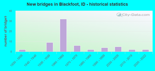
- New bridges - historical statistics
- 21930-1939
- 91950-1959
- 321960-1969
- 61970-1979
- 21980-1989
- 41990-1999
- 52000-2009
- 22010-2019
- 22020-2022
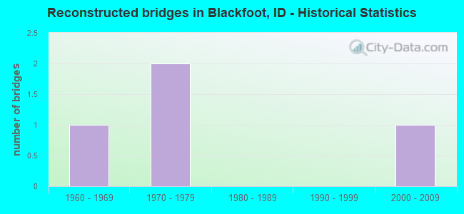
- Reconstructed bridges - Historical Statistics
- 11960-1969
- 21970-1979
- 01980-1989
- 01990-1999
- 12000-2009
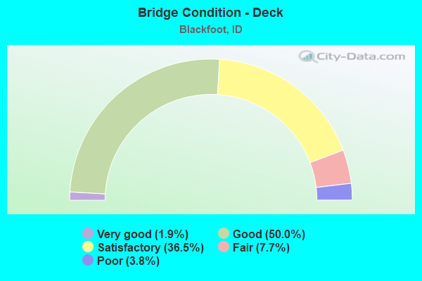
- Bridge Condition - Deck
- 1.9%Very good
- 50.0%Good
- 36.5%Satisfactory
- 7.7%Fair
- 3.8%Poor
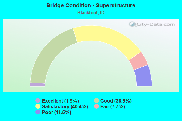
- Bridge Condition - Superstructure
- 1.9%Excellent
- 38.5%Good
- 40.4%Satisfactory
- 7.7%Fair
- 11.5%Poor
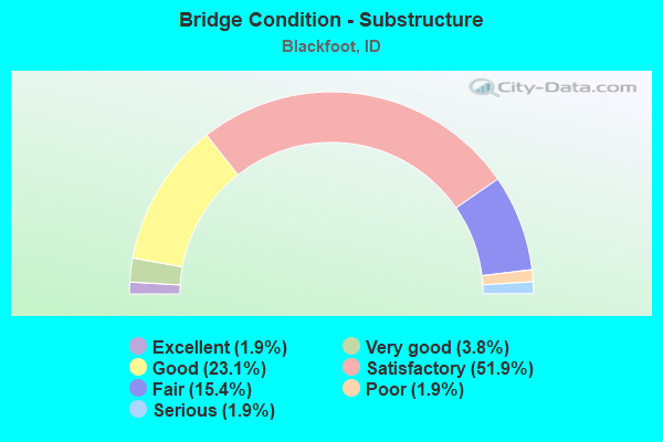
- Bridge Condition - Substructure
- 1.9%Excellent
- 3.8%Very good
- 23.1%Good
- 51.9%Satisfactory
- 15.4%Fair
- 1.9%Poor
- 1.9%Serious
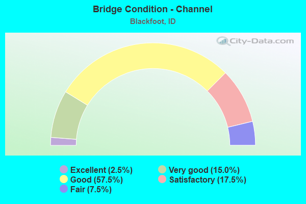
- Bridge Condition - Channel
- 2.5%Excellent
- 15.0%Very good
- 57.5%Good
- 17.5%Satisfactory
- 7.5%Fair
Find on map >> Show street view
Structure Number: P413, Location: 9 KM E OF HWY 191&BLKFOOT (Lat: 43.190850, Lng: -112.227650), Route carried "on" structure: Federal lands road 8, Year Built: 1975, Status: Open, Structure Length: 2.77m (9.09ft), Average Daily Traffic: 210 (year 2021), Truck Traffic: 10%, Average Future Daily Traffic: 420 (year 2041), Design Load: HS 20, Features Intersected: BLACKFOOT RIVER
Minimum Vertical Clearance: 30+ m (98+ ft), Kilometerpoint: 9.000, Lanes on structure: 2, Owner: Bureau of Indian Affairs, Approaching Roadway Width: 7.5m (24.6ft), Material/Design: Prestressed concrete, Design/Construction: Tee Beam, Number Of Spans In Main Unit: 1, Length of Maximum Span: 27.1m (88.9ft), Curb-To-Curb Width: 9.1m (29.9ft), Out-to-Out Width: 10.1m (33.1ft)
Condition: Deck: Good, Superstructure: Good, Substructure: Good, Channel: Satisfactory, Operating Rating: 43.2 metric tons, Method Used To Determine Operating Rating: No rating analysis performed, Inventory Rating: 32.4 metric tons, Method Used To Determine Inventory Rating: No rating analysis performed, Structural Evaluation: Better than present minimum criteria, Deck Geometry: Equal to present minimum criteria, Waterway Adequacy: Meets minimum limits, Approach Roadway Alignment: Better than present minimum criteria, Designated Inspection Frequency: Every 24 months, Inspection Date: July 2021, Deck Structure Type: Concrete Cast-file-Place, Wearing Surface/Protective System: Wearing Surface: Monolithic Concrete
Find on map >> Show street view
Structure Number: P415, Location: 5 KM SW OF BLACKFOOT (Lat: 43.160639, Lng: -112.405222), Route carried "on" structure: Federal lands road 91, Year Built: 2015, Status: Open, Structure Length: 3.23m (10.60ft), Average Daily Traffic: 85 (year 2021), Truck Traffic: 5%, Average Future Daily Traffic: 160 (year 2041), Features Intersected: BLACKFOOT RIVER
Minimum Vertical Clearance: 30+ m (98+ ft), Kilometerpoint: 3.400, Lanes on structure: 2, Owner: Bureau of Indian Affairs, Approaching Roadway Width: 9.6m (31.5ft), Skew: 6 degrees, Material/Design: Prestressed concrete, Design/Construction: Slab, Number Of Spans In Main Unit: 1, Number Of Approach Spans: 1, Length of Maximum Span: 30.8m (101.0ft), Curb-To-Curb Width: 9.6m (31.5ft), Out-to-Out Width: 10.2m (33.5ft)
Condition: Deck: Good, Superstructure: Good, Substructure: Very good, Channel: Excellent, Operating Rating: 96.1 metric tons, Method Used To Determine Operating Rating: Load Factor (LF), Inventory Rating: 41.8 metric tons, Method Used To Determine Inventory Rating: Load Factor (LF), Structural Evaluation: Better than present minimum criteria, Deck Geometry: Better than present minimum criteria, Waterway Adequacy: Equal to present desirable criteria, Approach Roadway Alignment: Equal to present desirable criteria, Designated Inspection Frequency: Every 24 months, Inspection Date: July 2021, Total Project Cost: $660,000 ( Estimate for 2021), Deck Structure Type: Concrete Precast Panels, Wearing Surface/Protective System: Wearing Surface: Bituminous
Find on map >> Show street view
Structure Number: P416, Location: 19 KM N.E. OF BLACKFOOT (Lat: 43.253306, Lng: -112.140056), Route carried "on" structure: Federal lands road 15, Year Built: 1978, Status: Posted for load, Structure Length: 2.59m (8.50ft), Average Daily Traffic: 100 (year 2021), Truck Traffic: 10%, Average Future Daily Traffic: 200 (year 2041), Features Intersected: BLACKFOOT RIVER
Minimum Vertical Clearance: 30+ m (98+ ft), Kilometerpoint: 31.400, Lanes on structure: 2, Owner: Bureau of Indian Affairs, Approaching Roadway Width: 8.5m (27.9ft), Skew: 3 degrees, Material/Design: Prestressed concrete, Design/Construction: Slab, Number Of Spans In Main Unit: 1, Length of Maximum Span: 24.7m (81.0ft), Curb-To-Curb Width: 9.1m (29.9ft), Out-to-Out Width: 10.1m (33.1ft)
Condition: Deck: Fair, Superstructure: Fair, Substructure: Satisfactory, Channel: Fair, Operating Rating: 47.0 metric tons, Method Used To Determine Operating Rating: Load Factor (LF), Inventory Rating: 28.1 metric tons, Method Used To Determine Inventory Rating: Load Factor (LF), Structural Evaluation: Somewhat better than minimum adequacy, Deck Geometry: Better than present minimum criteria, Waterway Adequacy: Equal to present minimum criteria, Approach Roadway Alignment: Better than present minimum criteria, Bridge Posting: Required (Relationship of Operating Rating to Maximum Legal Load: 20.0 - 29.9% below), Designated Inspection Frequency: Every 24 months, Inspection Date: July 2021, Total Project Cost: $480,000 ( Estimate for 2021), Deck Structure Type: Concrete Precast Panels, Wearing Surface/Protective System: Wearing Surface: Bituminous
Find on map >> Show street view
Structure Number: P422, Location: 10 KM SOUTH OF BLACKFOOT (Lat: 43.103917, Lng: -112.391528), Route carried "on" structure: Federal lands road 33, Year Built: 1972, Status: Open, Structure Length: 2.81m (9.22ft), Average Daily Traffic: 80 (year 2021), Truck Traffic: 10%, Average Future Daily Traffic: 160 (year 2041), Design Load: HS 20, Features Intersected: MAIN CANAL
Minimum Vertical Clearance: 30+ m (98+ ft), Kilometerpoint: 10.000, Lanes on structure: 2, Owner: Bureau of Indian Affairs, Approaching Roadway Width: 9.3m (30.5ft), Skew: 3 degrees, Material/Design: Prestressed concrete, Design/Construction: Tee Beam, Number Of Spans In Main Unit: 1, Length of Maximum Span: 27.1m (88.9ft), Curb-To-Curb Width: 9.1m (29.9ft), Out-to-Out Width: 10.1m (33.1ft)
Condition: Deck: Satisfactory, Superstructure: Good, Substructure: Good, Channel: Satisfactory, Operating Rating: 42.3 metric tons, Method Used To Determine Operating Rating: Load Factor (LF), Inventory Rating: 32.4 metric tons, Method Used To Determine Inventory Rating: Load Factor (LF), Structural Evaluation: Better than present minimum criteria, Deck Geometry: Better than present minimum criteria, Waterway Adequacy: Meets minimum limits, Approach Roadway Alignment: Equal to present minimum criteria, Designated Inspection Frequency: Every 24 months, Inspection Date: July 2021, Deck Structure Type: Concrete Cast-file-Place, Wearing Surface/Protective System: Wearing Surface: Monolithic Concrete
Find on map >> Show street view
Structure Number: P424, Location: 2 KM SE OF JCT US 191& 26 (Lat: 43.166611, Lng: -112.338361), Route carried "on" structure: Federal lands road 10, Year Built: 1991, Status: Open, Structure Length: 1.54m (5.05ft), Average Daily Traffic: 30 (year 2021), Truck Traffic: 10%, Average Future Daily Traffic: 70 (year 2041), Design Load: HS 15, Features Intersected: NORTH CANAL
Minimum Vertical Clearance: 30+ m (98+ ft), Kilometerpoint: 2.400, Lanes on structure: 2, Owner: Bureau of Indian Affairs, Approaching Roadway Width: 8.0m (26.2ft), Material/Design: Prestressed concrete, Design/Construction: Channel Beam, Number Of Spans In Main Unit: 1, Length of Maximum Span: 14.6m (47.9ft), Curb-To-Curb Width: 7.2m (23.6ft), Out-to-Out Width: 8.2m (26.9ft)
Condition: Deck: Good, Superstructure: Good, Substructure: Satisfactory, Channel: Fair, Operating Rating: 32.4 metric tons, Method Used To Determine Operating Rating: No rating analysis performed, Inventory Rating: 24.3 metric tons, Method Used To Determine Inventory Rating: No rating analysis performed, Structural Evaluation: Equal to present minimum criteria, Deck Geometry: Somewhat better than minimum adequacy, Waterway Adequacy: High priority of corrective action, Approach Roadway Alignment: Meets minimum limits, Length Of Structure Improvement: 1.80m (5.91ft), Designated Inspection Frequency: Every 24 months, Inspection Date: July 2021, Total Project Cost: $36,000 ( Estimate for 2021), Deck Structure Type: Concrete Precast Panels, Wearing Surface/Protective System: Wearing Surface: Bituminous
Find on map >> Show street view
Structure Number: 11415, Location: 5.5 S. BLACKFOOT (Lat: 43.124031, Lng: -112.388306), Route carried "on" structure: Interstate 15, Year Built: 1959, Status: Open, Structure Length: 0.64m (2.10ft), Average Daily Traffic: 13,000 (year 2019), Truck Traffic: 17%, Average Future Daily Traffic: 19,500 (year 2039), Design Load: HS 20, Features Intersected: GIBSON CANAL
Minimum Vertical Clearance: 30+ m (98+ ft), Kilometerpoint: 140.119, Lanes on structure: 2, Base Highway Network: Yes, Owner: State Highway Agency, Approaching Roadway Width: 11.6m (38.1ft), Skew: 4 degrees, Material/Design: Concrete, Design/Construction: Frame, Number Of Spans In Main Unit: 1, Length of Maximum Span: 6.4m (21.0ft), Curb-To-Curb Width: 11.8m (38.7ft), Out-to-Out Width: 14.7m (48.2ft)
Condition: Deck: Satisfactory, Superstructure: Satisfactory, Substructure: Satisfactory, Channel: Very good, Operating Rating: 51.7 metric tons, Method Used To Determine Operating Rating: Load Factor (LF), Inventory Rating: 30.8 metric tons, Method Used To Determine Inventory Rating: Load Factor (LF), Structural Evaluation: Equal to present minimum criteria, Deck Geometry: Equal to present minimum criteria, Waterway Adequacy: Equal to present desirable criteria, Approach Roadway Alignment: Equal to present desirable criteria, Designated Inspection Frequency: Every 48 months, Inspection Date: Febuary 2021, Deck Structure Type: Concrete Cast-file-Place, Wearing Surface/Protective System: Wearing Surface: Bituminous
Find on map >> Show street view
Structure Number: 1142, Location: 5.5 S. BLACKFOOT (Lat: 43.123911, Lng: -112.388797), Route carried "on" structure: Interstate 15, Year Built: 1959, Status: Open, Structure Length: 0.64m (2.10ft), Average Daily Traffic: 13,000 (year 2019), Truck Traffic: 17%, Average Future Daily Traffic: 19,500 (year 2039), Design Load: HS 20, Features Intersected: GIBSON CANAL
Minimum Vertical Clearance: 30+ m (98+ ft), Kilometerpoint: 140.121, Lanes on structure: 2, Base Highway Network: Yes, Owner: State Highway Agency, Approaching Roadway Width: 11.9m (39.0ft), Skew: 4 degrees, Material/Design: Concrete, Design/Construction: Frame, Number Of Spans In Main Unit: 1, Length of Maximum Span: 6.4m (21.0ft), Curb-To-Curb Width: 12.0m (39.4ft), Out-to-Out Width: 14.3m (46.9ft)
Condition: Deck: Good, Superstructure: Good, Substructure: Good, Channel: Very good, Operating Rating: 51.7 metric tons, Method Used To Determine Operating Rating: Load Factor (LF), Inventory Rating: 30.8 metric tons, Method Used To Determine Inventory Rating: Load Factor (LF), Structural Evaluation: Better than present minimum criteria, Deck Geometry: Equal to present minimum criteria, Waterway Adequacy: Equal to present desirable criteria, Approach Roadway Alignment: Equal to present desirable criteria, Designated Inspection Frequency: Every 48 months, Inspection Date: Febuary 2021, Deck Structure Type: Concrete Cast-file-Place, Wearing Surface/Protective System: Wearing Surface: Bituminous
Find on map >> Show street view
Structure Number: 1144, Location: 3.8 S. BLACKFOOT (Lat: 43.149250, Lng: -112.388861), Route carried "on" structure: Interstate 15, Year Built: 1961, Status: Open, Structure Length: 11.95m (39.21ft), Average Daily Traffic: 13,000 (year 2019), Truck Traffic: 17%, Average Future Daily Traffic: 19,500 (year 2039), Design Load: HS 20, Features Intersected: I15B;UPRR;S.BLACKFOOT IC
Minimum Vertical Clearance: 30+ m (98+ ft), Kilometerpoint: 142.850, Lanes on structure: 2, Lanes under structure: 2, Base Highway Network: Yes, Owner: State Highway Agency, Approaching Roadway Width: 11.6m (38.1ft), Skew: 3 degrees, Material/Design: Prestressed concrete, Design/Construction: Stringer/Multi-beam, Number Of Spans In Main Unit: 5, Length of Maximum Span: 23.8m (78.1ft), Curb-To-Curb Width: 9.1m (29.9ft), Out-to-Out Width: 10.6m (34.8ft)
Condition: Deck: Poor, Superstructure: Poor, Substructure: Satisfactory, Operating Rating: 64.4 metric tons, Method Used To Determine Operating Rating: Load Factor (LF), Inventory Rating: 39.0 metric tons, Method Used To Determine Inventory Rating: Load Factor (LF), Structural Evaluation: Meets minimum limits, Deck Geometry: Meets minimum limits, Underclear: Meets minimum limits, Approach Roadway Alignment: Equal to present desirable criteria, Length Of Structure Improvement: 12.80m (41.99ft), Designated Inspection Frequency: Every 12 months, Inspection Date: June 2021, Bridge Improvement Cost: $2,910,000, Roadway Improvement Cost: $291,000, Total Project Cost: $4,366,000 ( Estimate for 2019), Deck Structure Type: Concrete Cast-file-Place, Wearing Surface/Protective System: Wearing Surface: Bituminous
Find on map >> Show street view
Structure Number: 11445, Location: 3.8 S. BLACKFOOT (Lat: 43.148500, Lng: -112.388500), Route carried "on" structure: Interstate 15, Year Built: 1961, Status: Open, Structure Length: 11.95m (39.21ft), Average Daily Traffic: 13,000 (year 2019), Truck Traffic: 17%, Average Future Daily Traffic: 19,500 (year 2039), Design Load: HS 20, Features Intersected: I15B;UPRR;S.BLACKFOOT IC
Minimum Vertical Clearance: 30+ m (98+ ft), Kilometerpoint: 142.852, Lanes on structure: 2, Lanes under structure: 2, Base Highway Network: Yes, Owner: State Highway Agency, Approaching Roadway Width: 11.6m (38.1ft), Skew: 3 degrees, Material/Design: Prestressed concrete, Design/Construction: Stringer/Multi-beam, Number Of Spans In Main Unit: 5, Length of Maximum Span: 23.8m (78.1ft), Curb-To-Curb Width: 9.1m (29.9ft), Out-to-Out Width: 10.6m (34.8ft)
Condition: Deck: Poor, Superstructure: Poor, Substructure: Satisfactory, Operating Rating: 64.4 metric tons, Method Used To Determine Operating Rating: Load Factor (LF), Inventory Rating: 39.0 metric tons, Method Used To Determine Inventory Rating: Load Factor (LF), Structural Evaluation: Meets minimum limits, Deck Geometry: Meets minimum limits, Underclear: Meets minimum limits, Approach Roadway Alignment: Equal to present desirable criteria, Length Of Structure Improvement: 12.80m (41.99ft), Designated Inspection Frequency: Every 12 months, Inspection Date: June 2021, Bridge Improvement Cost: $2,910,000, Roadway Improvement Cost: $291,000, Total Project Cost: $4,366,000 ( Estimate for 2019), Deck Structure Type: Concrete Cast-file-Place, Wearing Surface/Protective System: Wearing Surface: Bituminous
Find on map >> Show street view
Structure Number: 1145, Location: 2.2 S. BLACKFOOT (Lat: 43.171667, Lng: -112.386000), Route carried "on" structure: Interstate 15, Year Built: 1962, Status: Open, Structure Length: 4.72m (15.49ft), Average Daily Traffic: 12,000 (year 2019), Truck Traffic: 18%, Average Future Daily Traffic: 18,000 (year 2039), Design Load: HS 20, Features Intersected: BLACKFOOT RIVER
Minimum Vertical Clearance: 30+ m (98+ ft), Kilometerpoint: 145.389, Lanes on structure: 2, Base Highway Network: Yes, Owner: State Highway Agency, Approaching Roadway Width: 11.6m (38.1ft), Skew: 6 degrees, Material/Design: Prestressed concrete, Design/Construction: Stringer/Multi-beam, Number Of Spans In Main Unit: 3, Length of Maximum Span: 14.9m (48.9ft), Curb-To-Curb Width: 11.6m (38.1ft), Out-to-Out Width: 12.2m (40.0ft)
Condition: Deck: Good, Superstructure: Satisfactory, Substructure: Satisfactory, Channel: Good, Operating Rating: 59.0 metric tons, Method Used To Determine Operating Rating: Load Factor (LF), Inventory Rating: 35.4 metric tons, Method Used To Determine Inventory Rating: Load Factor (LF), Structural Evaluation: Equal to present minimum criteria, Deck Geometry: Equal to present minimum criteria, Waterway Adequacy: Superior to present desirable criteria, Approach Roadway Alignment: Equal to present desirable criteria, Designated Inspection Frequency: Every 24 months, Underwater Inspection Frequency: Every 60 months, Inspection Date: November 2021, Underwater Inspection Date: October 2017, Deck Structure Type: Concrete Cast-file-Place, Wearing Surface/Protective System: Wearing Surface: Latex Concrete
Find on map >> Show street view
Structure Number: 11455, Location: 2.2 S. BLACKFOOT (Lat: 43.171694, Lng: -112.386403), Route carried "on" structure: Interstate 15, Year Built: 1962, Status: Open, Structure Length: 4.72m (15.49ft), Average Daily Traffic: 12,000 (year 2019), Truck Traffic: 18%, Average Future Daily Traffic: 18,000 (year 2039), Design Load: HS 20, Features Intersected: BLACKFOOT RIVER
Minimum Vertical Clearance: 30+ m (98+ ft), Kilometerpoint: 145.391, Lanes on structure: 2, Base Highway Network: Yes, Owner: State Highway Agency, Approaching Roadway Width: 11.6m (38.1ft), Skew: 6 degrees, Material/Design: Prestressed concrete, Design/Construction: Stringer/Multi-beam, Number Of Spans In Main Unit: 3, Length of Maximum Span: 14.9m (48.9ft), Curb-To-Curb Width: 11.6m (38.1ft), Out-to-Out Width: 12.2m (40.0ft)
Condition: Deck: Good, Superstructure: Satisfactory, Substructure: Satisfactory, Channel: Satisfactory, Operating Rating: 59.9 metric tons, Method Used To Determine Operating Rating: Load Factor (LF), Inventory Rating: 35.4 metric tons, Method Used To Determine Inventory Rating: Load Factor (LF), Structural Evaluation: Equal to present minimum criteria, Deck Geometry: Equal to present minimum criteria, Waterway Adequacy: Superior to present desirable criteria, Approach Roadway Alignment: Equal to present desirable criteria, Designated Inspection Frequency: Every 24 months, Underwater Inspection Frequency: Every 60 months, Inspection Date: November 2021, Underwater Inspection Date: October 2017, Deck Structure Type: Concrete Cast-file-Place, Wearing Surface/Protective System: Wearing Surface: Latex Concrete
Find on map >> Show street view
Structure Number: 11465, Location: 0.3 S. BLACKFOOT (Lat: 43.194722, Lng: -112.367056), Route carried "on" structure: Interstate 15, Year Built: 1962, Status: Open, Structure Length: 9.11m (29.89ft), Average Daily Traffic: 12,000 (year 2019), Truck Traffic: 18%, Average Future Daily Traffic: 18,000 (year 2039), Design Load: HS 20, Features Intersected: W.BRIDGE ST.GS;UPRR OP
Minimum Vertical Clearance: 30+ m (98+ ft), Kilometerpoint: 148.476, Lanes on structure: 2, Lanes under structure: 2, Base Highway Network: Yes, Owner: State Highway Agency, Approaching Roadway Width: 11.6m (38.1ft), Material/Design: Prestressed concrete, Design/Construction: Stringer/Multi-beam, Number Of Spans In Main Unit: 6, Length of Maximum Span: 15.5m (50.9ft), Curb-To-Curb Width: 11.6m (38.1ft), Out-to-Out Width: 12.2m (40.0ft)
Condition: Deck: Fair, Superstructure: Fair, Substructure: Satisfactory, Operating Rating: 68.0 metric tons, Method Used To Determine Operating Rating: Load Factor (LF), Inventory Rating: 40.8 metric tons, Method Used To Determine Inventory Rating: Load Factor (LF), Structural Evaluation: Somewhat better than minimum adequacy, Deck Geometry: Equal to present minimum criteria, Underclear: High priority of corrective action, Approach Roadway Alignment: Equal to present desirable criteria, Designated Inspection Frequency: Every 24 months, Inspection Date: June 2020, Deck Structure Type: Concrete Cast-file-Place, Wearing Surface/Protective System: Wearing Surface: Bituminous
Find on map >> Show street view
Structure Number: 1147, Location: 0.3 S. BLACKFOOT (Lat: 43.195583, Lng: -112.366722), Route carried "on" structure: Interstate 15, Year Built: 1962, Status: Open, Structure Length: 7.86m (25.79ft), Average Daily Traffic: 12,000 (year 2019), Truck Traffic: 18%, Average Future Daily Traffic: 18,000 (year 2039), Design Load: HS 20, Features Intersected: W.BRIDGE ST.GS;UPRR OP
Minimum Vertical Clearance: 30+ m (98+ ft), Kilometerpoint: 148.478, Lanes on structure: 2, Lanes under structure: 2, Base Highway Network: Yes, Owner: State Highway Agency, Approaching Roadway Width: 11.6m (38.1ft), Material/Design: Prestressed concrete, Design/Construction: Stringer/Multi-beam, Number Of Spans In Main Unit: 5, Length of Maximum Span: 16.8m (55.1ft), Curb-To-Curb Width: 11.6m (38.1ft), Out-to-Out Width: 12.2m (40.0ft)
Condition: Deck: Fair, Superstructure: Fair, Substructure: Satisfactory, Operating Rating: 68.0 metric tons, Method Used To Determine Operating Rating: Load Factor (LF), Inventory Rating: 40.8 metric tons, Method Used To Determine Inventory Rating: Load Factor (LF), Structural Evaluation: Somewhat better than minimum adequacy, Deck Geometry: Equal to present minimum criteria, Underclear: High priority of corrective action, Approach Roadway Alignment: Equal to present desirable criteria, Designated Inspection Frequency: Every 24 months, Inspection Date: June 2020, Deck Structure Type: Concrete Cast-file-Place, Wearing Surface/Protective System: Wearing Surface: Bituminous
Find on map >> Show street view
Structure Number: 11475, Location: AT BLACKFOOT (Lat: 43.198472, Lng: -112.363778), Route carried "on" structure: Interstate 15, Year Built: 1962, Status: Open, Structure Length: 4.79m (15.72ft), Average Daily Traffic: 12,000 (year 2019), Truck Traffic: 18%, Average Future Daily Traffic: 18,000 (year 2039), Design Load: HS 20, Features Intersected: US 26;WEST BLACKFOOT IC
Minimum Vertical Clearance: 30+ m (98+ ft), Kilometerpoint: 148.888, Lanes on structure: 2, Lanes under structure: 5, Base Highway Network: Yes, Owner: State Highway Agency, Approaching Roadway Width: 11.6m (38.1ft), Material/Design: Concrete, Design/Construction: Stringer/Multi-beam, Number Of Spans In Main Unit: 4, Length of Maximum Span: 14.6m (47.9ft), Curb-To-Curb Width: 11.6m (38.1ft), Out-to-Out Width: 12.2m (40.0ft)
Condition: Deck: Satisfactory, Superstructure: Satisfactory, Substructure: Satisfactory, Operating Rating: 49.0 metric tons, Method Used To Determine Operating Rating: Load Factor (LF), Inventory Rating: 29.0 metric tons, Method Used To Determine Inventory Rating: Load Factor (LF), Structural Evaluation: Equal to present minimum criteria, Deck Geometry: Equal to present minimum criteria, Underclear: High priority of corrective action, Approach Roadway Alignment: Equal to present desirable criteria, Designated Inspection Frequency: Every 48 months, Inspection Date: June 2020, Deck Structure Type: Concrete Cast-file-Place, Wearing Surface/Protective System: Wearing Surface: Bituminous
Find on map >> Show street view
Structure Number: 1148, Location: AT BLACKFOOT (Lat: 43.198972, Lng: -112.363806), Route carried "on" structure: Interstate 15, Year Built: 1962, Status: Open, Structure Length: 4.79m (15.72ft), Average Daily Traffic: 12,000 (year 2019), Truck Traffic: 18%, Average Future Daily Traffic: 18,000 (year 2039), Design Load: HS 20, Features Intersected: US 26;WEST BLACKFOOT IC
Minimum Vertical Clearance: 30+ m (98+ ft), Kilometerpoint: 148.890, Lanes on structure: 2, Lanes under structure: 5, Base Highway Network: Yes, Owner: State Highway Agency, Approaching Roadway Width: 11.6m (38.1ft), Material/Design: Concrete, Design/Construction: Stringer/Multi-beam, Number Of Spans In Main Unit: 4, Length of Maximum Span: 14.6m (47.9ft), Curb-To-Curb Width: 11.6m (38.1ft), Out-to-Out Width: 12.2m (40.0ft)
Condition: Deck: Satisfactory, Superstructure: Poor, Substructure: Satisfactory, Operating Rating: 49.0 metric tons, Method Used To Determine Operating Rating: Load Factor (LF), Inventory Rating: 29.0 metric tons, Method Used To Determine Inventory Rating: Load Factor (LF), Structural Evaluation: Meets minimum limits, Deck Geometry: Equal to present minimum criteria, Underclear: High priority of corrective action, Approach Roadway Alignment: Equal to present desirable criteria, Designated Inspection Frequency: Every 12 months, Inspection Date: October 2021, Deck Structure Type: Concrete Cast-file-Place, Wearing Surface/Protective System: Wearing Surface: Bituminous
Find on map >> Show street view
Structure Number: 11486, Location: 1.9 N. BLACKFOOT (Lat: 43.221083, Lng: -112.343889), Route carried "on" structure: Interstate 15, Year Built: 2003, Status: Open, Structure Length: 25.33m (83.10ft), Average Daily Traffic: 12,500 (year 2019), Truck Traffic: 17%, Average Future Daily Traffic: 18,750 (year 2039), Design Load: HS 25 or greater, Features Intersected: SNAKE RIVER;BLACKFOOT BR
Minimum Vertical Clearance: 30+ m (98+ ft), Kilometerpoint: 151.840, Lanes on structure: 2, Base Highway Network: Yes, Owner: State Highway Agency, Approaching Roadway Width: 11.6m (38.1ft), Skew: 4 degrees, Material/Design: Prestressed concrete continuous, Design/Construction: Stringer/Multi-beam, Number Of Spans In Main Unit: 7, Length of Maximum Span: 36.0m (118.1ft), Curb or Sidewalk Widths: Left: 0.0m, Right: 3.6m (11.8ft), Curb-To-Curb Width: 12.4m (40.7ft), Out-to-Out Width: 17.2m (56.4ft)
Condition: Deck: Satisfactory, Superstructure: Satisfactory, Substructure: Good, Channel: Good, Operating Rating: 94.3 metric tons, Method Used To Determine Operating Rating: Load Factor (LF), Inventory Rating: 43.5 metric tons, Method Used To Determine Inventory Rating: Load Factor (LF), Structural Evaluation: Equal to present minimum criteria, Deck Geometry: Better than present minimum criteria, Waterway Adequacy: Equal to present desirable criteria, Approach Roadway Alignment: Equal to present desirable criteria, Designated Inspection Frequency: Every 48 months, Underwater Inspection Frequency: Every 60 months, Inspection Date: September 2018, Underwater Inspection Date: October 2020, Deck Structure Type: Concrete Cast-file-Place, Wearing Surface/Protective System: Wearing Surface: Monolithic Concrete, Deck Protection: Epoxy Coated Reinforcing
Find on map >> Show street view
Structure Number: 11491, Location: 1.9 N. BLACKFOOT (Lat: 43.223003, Lng: -112.342731), Route carried "on" structure: Interstate 15, Year Built: 2002, Status: Open, Structure Length: 25.33m (83.10ft), Average Daily Traffic: 12,500 (year 2019), Truck Traffic: 17%, Average Future Daily Traffic: 18,750 (year 2039), Design Load: HS 25 or greater, Features Intersected: SNAKE RIVER;BLACKFOOT BR
Minimum Vertical Clearance: 30+ m (98+ ft), Kilometerpoint: 151.842, Lanes on structure: 2, Base Highway Network: Yes (Inventory Route: I, Subroute: 1), Owner: State Highway Agency, Approaching Roadway Width: 12.2m (40.0ft), Skew: 4 degrees, Material/Design: Prestressed concrete continuous, Design/Construction: Stringer/Multi-beam, Number Of Spans In Main Unit: 7, Length of Maximum Span: 36.0m (118.1ft), Curb-To-Curb Width: 12.4m (40.7ft), Out-to-Out Width: 13.2m (43.3ft)
Condition: Deck: Satisfactory, Superstructure: Satisfactory, Substructure: Satisfactory, Channel: Good, Operating Rating: 90.6 metric tons, Method Used To Determine Operating Rating: Load Factor (LF), Inventory Rating: 48.1 metric tons, Method Used To Determine Inventory Rating: Load Factor (LF), Structural Evaluation: Equal to present minimum criteria, Deck Geometry: Better than present minimum criteria, Waterway Adequacy: Equal to present desirable criteria, Approach Roadway Alignment: Equal to present desirable criteria, Designated Inspection Frequency: Every 48 months, Underwater Inspection Frequency: Every 60 months, Inspection Date: September 2018, Underwater Inspection Date: October 2020, Deck Structure Type: Concrete Cast-file-Place, Wearing Surface/Protective System: Wearing Surface: Monolithic Concrete, Deck Protection: Epoxy Coated Reinforcing
Find on map >> Show street view
Structure Number: 11495, Location: 2.1 N. BLACKFOOT (Lat: 43.223694, Lng: -112.341639), Route carried "on" structure: Interstate 15, Year Built: 1962, Status: Open, Structure Length: 2.74m (8.99ft), Average Daily Traffic: 12,500 (year 2019), Truck Traffic: 17%, Average Future Daily Traffic: 18,750 (year 2039), Design Load: HS 20, Features Intersected: DANSKIN CANAL
Minimum Vertical Clearance: 30+ m (98+ ft), Kilometerpoint: 152.188, Lanes on structure: 2, Base Highway Network: Yes, Owner: State Highway Agency, Approaching Roadway Width: 11.6m (38.1ft), Skew: 2 degrees, Material/Design: Concrete, Design/Construction: Stringer/Multi-beam, Number Of Spans In Main Unit: 3, Length of Maximum Span: 9.1m (29.9ft), Curb-To-Curb Width: 11.6m (38.1ft), Out-to-Out Width: 12.3m (40.4ft)
Condition: Deck: Good, Superstructure: Satisfactory, Substructure: Good, Channel: Satisfactory, Operating Rating: 64.4 metric tons, Method Used To Determine Operating Rating: Load Factor (LF), Inventory Rating: 38.1 metric tons, Method Used To Determine Inventory Rating: Load Factor (LF), Structural Evaluation: Equal to present minimum criteria, Deck Geometry: Equal to present minimum criteria, Waterway Adequacy: Equal to present desirable criteria, Approach Roadway Alignment: Equal to present desirable criteria, Designated Inspection Frequency: Every 48 months, Inspection Date: March 2020, Deck Structure Type: Concrete Cast-file-Place, Wearing Surface/Protective System: Wearing Surface: Bituminous
Find on map >> Show street view
Structure Number: 115, Location: 2.1 N. BLACKFOOT (Lat: 43.223944, Lng: -112.341889), Route carried "on" structure: Interstate 15, Year Built: 1962, Status: Open, Structure Length: 2.74m (8.99ft), Average Daily Traffic: 12,500 (year 2019), Truck Traffic: 17%, Average Future Daily Traffic: 18,750 (year 2039), Design Load: HS 20, Features Intersected: DANSKIN CANAL
Minimum Vertical Clearance: 30+ m (98+ ft), Kilometerpoint: 152.189, Lanes on structure: 2, Base Highway Network: Yes, Owner: State Highway Agency, Approaching Roadway Width: 11.6m (38.1ft), Skew: 2 degrees, Material/Design: Concrete, Design/Construction: Stringer/Multi-beam, Number Of Spans In Main Unit: 3, Length of Maximum Span: 9.1m (29.9ft), Curb-To-Curb Width: 11.6m (38.1ft), Out-to-Out Width: 12.3m (40.4ft)
Condition: Deck: Good, Superstructure: Good, Substructure: Good, Channel: Good, Operating Rating: 64.4 metric tons, Method Used To Determine Operating Rating: Load Factor (LF), Inventory Rating: 38.1 metric tons, Method Used To Determine Inventory Rating: Load Factor (LF), Structural Evaluation: Better than present minimum criteria, Deck Geometry: Equal to present minimum criteria, Waterway Adequacy: Equal to present desirable criteria, Approach Roadway Alignment: Equal to present desirable criteria, Designated Inspection Frequency: Every 48 months, Inspection Date: March 2020, Deck Structure Type: Concrete Cast-file-Place, Wearing Surface/Protective System: Wearing Surface: Bituminous
Find on map >> Show street view
Structure Number: 11515, Location: 2.5 N. BLACKFOOT (Lat: 43.229139, Lng: -112.337306), Route carried "on" structure: Interstate 15, Year Built: 1962, Status: Open, Structure Length: 0.98m (3.22ft), Average Daily Traffic: 12,500 (year 2019), Truck Traffic: 17%, Average Future Daily Traffic: 18,750 (year 2039), Design Load: HS 20, Features Intersected: RIVERSIDE CANAL
Minimum Vertical Clearance: 30+ m (98+ ft), Kilometerpoint: 152.905, Lanes on structure: 2, Base Highway Network: Yes, Owner: State Highway Agency, Approaching Roadway Width: 11.6m (38.1ft), Skew: 4 degrees, Material/Design: Concrete, Design/Construction: Frame, Number Of Spans In Main Unit: 1, Length of Maximum Span: 9.8m (32.2ft), Curb-To-Curb Width: 11.9m (39.0ft), Out-to-Out Width: 14.6m (47.9ft)
Condition: Deck: Good, Superstructure: Good, Substructure: Good, Channel: Good, Operating Rating: 65.3 metric tons, Method Used To Determine Operating Rating: Load Factor (LF), Inventory Rating: 39.0 metric tons, Method Used To Determine Inventory Rating: Load Factor (LF), Structural Evaluation: Better than present minimum criteria, Deck Geometry: Equal to present minimum criteria, Waterway Adequacy: Equal to present desirable criteria, Approach Roadway Alignment: Equal to present desirable criteria, Designated Inspection Frequency: Every 48 months, Inspection Date: March 2020, Deck Structure Type: Concrete Cast-file-Place, Wearing Surface/Protective System: Wearing Surface: Bituminous
Find on map >> Show street view
Structure Number: 1152, Location: 3.3 N. BLACKFOOT (Lat: 43.238389, Lng: -112.328778), Route carried "on" structure: Interstate 15, Year Built: 1962, Status: Open, Structure Length: 0.76m (2.49ft), Average Daily Traffic: 12,500 (year 2019), Truck Traffic: 17%, Average Future Daily Traffic: 18,750 (year 2039), Design Load: HS 20, Features Intersected: RIVERSIDE CANAL
Minimum Vertical Clearance: 30+ m (98+ ft), Kilometerpoint: 154.140, Lanes on structure: 2, Base Highway Network: Yes, Owner: State Highway Agency, Approaching Roadway Width: 11.6m (38.1ft), Skew: 1 degrees, Material/Design: Concrete, Design/Construction: Frame, Number Of Spans In Main Unit: 1, Length of Maximum Span: 7.6m (24.9ft), Curb-To-Curb Width: 11.7m (38.4ft), Out-to-Out Width: 14.6m (47.9ft)
Condition: Deck: Good, Superstructure: Good, Substructure: Satisfactory, Channel: Good, Operating Rating: 59.0 metric tons, Method Used To Determine Operating Rating: Load Factor (LF), Inventory Rating: 35.4 metric tons, Method Used To Determine Inventory Rating: Load Factor (LF), Structural Evaluation: Equal to present minimum criteria, Deck Geometry: Equal to present minimum criteria, Waterway Adequacy: Equal to present desirable criteria, Approach Roadway Alignment: Equal to present desirable criteria, Designated Inspection Frequency: Every 48 months, Inspection Date: Febuary 2019, Deck Structure Type: Concrete Cast-file-Place, Wearing Surface/Protective System: Wearing Surface: Bituminous
Find on map >> Show street view
Structure Number: 11525, Location: 3.3 N. BLACKFOOT (Lat: 43.238694, Lng: -112.328944), Route carried "on" structure: Interstate 15, Year Built: 1962, Status: Open, Structure Length: 0.76m (2.49ft), Average Daily Traffic: 12,500 (year 2019), Truck Traffic: 17%, Average Future Daily Traffic: 18,750 (year 2039), Design Load: HS 20, Features Intersected: RIVERSIDE CANAL
Minimum Vertical Clearance: 30+ m (98+ ft), Kilometerpoint: 154.143, Lanes on structure: 2, Base Highway Network: Yes, Owner: State Highway Agency, Approaching Roadway Width: 11.6m (38.1ft), Skew: 1 degrees, Material/Design: Concrete, Design/Construction: Frame, Number Of Spans In Main Unit: 1, Length of Maximum Span: 7.6m (24.9ft), Curb-To-Curb Width: 11.8m (38.7ft), Out-to-Out Width: 14.6m (47.9ft)
Condition: Deck: Good, Superstructure: Good, Substructure: Satisfactory, Channel: Good, Operating Rating: 59.0 metric tons, Method Used To Determine Operating Rating: Load Factor (LF), Inventory Rating: 35.4 metric tons, Method Used To Determine Inventory Rating: Load Factor (LF), Structural Evaluation: Equal to present minimum criteria, Deck Geometry: Equal to present minimum criteria, Waterway Adequacy: Equal to present desirable criteria, Approach Roadway Alignment: Equal to present desirable criteria, Designated Inspection Frequency: Every 48 months, Inspection Date: Febuary 2019, Deck Structure Type: Concrete Cast-file-Place, Wearing Surface/Protective System: Wearing Surface: Bituminous
Find on map >> Show street view
Structure Number: 11536, Location: 4.8 N. BLACKFOOT (Lat: 43.256750, Lng: -112.313139), Route carried "on" structure: Interstate 15, Year Built: 2019, Status: Open, Structure Length: 1.13m (3.71ft), Average Daily Traffic: 25,000 (year 2019), Truck Traffic: 17%, Average Future Daily Traffic: 37,500 (year 2039), Design Load: HL 93, Features Intersected: RIVERSIDE CANAL
Minimum Vertical Clearance: 30+ m (98+ ft), Kilometerpoint: 156.628, Lanes on structure: 4, Base Highway Network: Yes, Owner: State Highway Agency, Approaching Roadway Width: 27.7m (90.9ft), Skew: 13 degrees, Material/Design: Concrete, Design/Construction: Frame, Number Of Spans In Main Unit: 1, Length of Maximum Span: 11.3m (37.1ft), Curb-To-Curb Width: 50.6m (166.0ft), Out-to-Out Width: 51.2m (168.0ft)
Condition: Deck: Good, Superstructure: Good, Substructure: Very good, Channel: Very good, Operating Rating: 64.2 metric tons, Method Used To Determine Operating Rating: Load and Resistance Factor Rating (LRFR) rating reported by rating factor(RF) method using HL-93 loadings, Inventory Rating: 49.6 metric tons, Method Used To Determine Inventory Rating: Load and Resistance Factor Rating (LRFR) rating reported by rating factor(RF) method using HL-93 loadings, Structural Evaluation: Better than present minimum criteria, Deck Geometry: Superior to present desirable criteria, Waterway Adequacy: Equal to present desirable criteria, Approach Roadway Alignment: Equal to present desirable criteria, Designated Inspection Frequency: Every 48 months, Inspection Date: Febuary 2021, Deck Structure Type: Concrete Precast Panels, Wearing Surface/Protective System: Wearing Surface: Bituminous, Membrane: Preformed Fabric
Find on map >> Show street view
Structure Number: 1155, Location: 5.8 N. BLACKFOOT (Lat: 43.269417, Lng: -112.302639), Route carried "on" structure: Interstate 15, Year Built: 1962, Status: Open, Structure Length: 3.66m (12.01ft), Average Daily Traffic: 12,500 (year 2019), Truck Traffic: 17%, Average Future Daily Traffic: 18,750 (year 2039), Design Load: HS 20, Features Intersected: ABERDEEN SPRINGFIELD CNL
Minimum Vertical Clearance: 30+ m (98+ ft), Kilometerpoint: 158.158, Lanes on structure: 2, Base Highway Network: Yes, Owner: State Highway Agency, Approaching Roadway Width: 11.6m (38.1ft), Skew: 4 degrees, Material/Design: Concrete, Design/Construction: Stringer/Multi-beam, Number Of Spans In Main Unit: 3, Length of Maximum Span: 11.9m (39.0ft), Curb-To-Curb Width: 11.6m (38.1ft), Out-to-Out Width: 12.3m (40.4ft)
Condition: Deck: Good, Superstructure: Good, Substructure: Fair, Channel: Good, Operating Rating: 60.8 metric tons, Method Used To Determine Operating Rating: Load Factor (LF), Inventory Rating: 36.3 metric tons, Method Used To Determine Inventory Rating: Load Factor (LF), Structural Evaluation: Somewhat better than minimum adequacy, Deck Geometry: Equal to present minimum criteria, Waterway Adequacy: Equal to present desirable criteria, Approach Roadway Alignment: Equal to present desirable criteria, Length Of Structure Improvement: 4.54m (14.90ft), Designated Inspection Frequency: Every 24 months, Inspection Date: Febuary 2021, Bridge Improvement Cost: $1,033,000, Roadway Improvement Cost: $103,000, Total Project Cost: $1,550,000 ( Estimate for 2015), Deck Structure Type: Concrete Cast-file-Place, Wearing Surface/Protective System: Wearing Surface: Latex Concrete
Find on map >> Show street view
Structure Number: 11555, Location: 5.8 N. BLACKFOOT (Lat: 43.269556, Lng: -112.302972), Route carried "on" structure: Interstate 15, Year Built: 1962, Status: Open, Structure Length: 3.66m (12.01ft), Average Daily Traffic: 12,500 (year 2019), Truck Traffic: 17%, Average Future Daily Traffic: 18,750 (year 2039), Design Load: HS 20, Features Intersected: ABERDEEN SPRINGFIELD CNL
Minimum Vertical Clearance: 30+ m (98+ ft), Kilometerpoint: 158.160, Lanes on structure: 2, Base Highway Network: Yes, Owner: State Highway Agency, Approaching Roadway Width: 11.6m (38.1ft), Skew: 4 degrees, Material/Design: Concrete, Design/Construction: Stringer/Multi-beam, Number Of Spans In Main Unit: 3, Length of Maximum Span: 11.9m (39.0ft), Curb-To-Curb Width: 11.6m (38.1ft), Out-to-Out Width: 12.3m (40.4ft)
Condition: Deck: Good, Superstructure: Satisfactory, Substructure: Fair, Channel: Good, Operating Rating: 60.8 metric tons, Method Used To Determine Operating Rating: Load Factor (LF), Inventory Rating: 36.3 metric tons, Method Used To Determine Inventory Rating: Load Factor (LF), Structural Evaluation: Somewhat better than minimum adequacy, Deck Geometry: Equal to present minimum criteria, Waterway Adequacy: Equal to present desirable criteria, Approach Roadway Alignment: Equal to present desirable criteria, Length Of Structure Improvement: 4.54m (14.90ft), Designated Inspection Frequency: Every 24 months, Inspection Date: Febuary 2021, Bridge Improvement Cost: $1,033,000, Roadway Improvement Cost: $103,000, Total Project Cost: $1,550,000 ( Estimate for 2015), Deck Structure Type: Concrete Cast-file-Place, Wearing Surface/Protective System: Wearing Surface: Latex Concrete
Find on map >> Show street view
Structure Number: 1156, Location: 5.8 N. BLACKFOOT (Lat: 43.269833, Lng: -112.302278), Route carried "on" structure: Interstate 15, Year Built: 1962, Status: Open, Structure Length: 2.44m (8.01ft), Average Daily Traffic: 12,500 (year 2019), Truck Traffic: 17%, Average Future Daily Traffic: 18,750 (year 2039), Design Load: HS 20, Features Intersected: PEOPLES CANAL
Minimum Vertical Clearance: 30+ m (98+ ft), Kilometerpoint: 158.219, Lanes on structure: 2, Base Highway Network: Yes, Owner: State Highway Agency, Approaching Roadway Width: 11.6m (38.1ft), Skew: 4 degrees, Material/Design: Concrete, Design/Construction: Stringer/Multi-beam, Number Of Spans In Main Unit: 2, Length of Maximum Span: 11.9m (39.0ft), Curb-To-Curb Width: 11.6m (38.1ft), Out-to-Out Width: 12.3m (40.4ft)
Condition: Deck: Good, Superstructure: Good, Substructure: Fair, Channel: Good, Operating Rating: 60.8 metric tons, Method Used To Determine Operating Rating: Load Factor (LF), Inventory Rating: 36.3 metric tons, Method Used To Determine Inventory Rating: Load Factor (LF), Structural Evaluation: Somewhat better than minimum adequacy, Deck Geometry: Equal to present minimum criteria, Waterway Adequacy: Equal to present desirable criteria, Approach Roadway Alignment: Equal to present desirable criteria, Length Of Structure Improvement: 3.17m (10.40ft), Designated Inspection Frequency: Every 24 months, Inspection Date: Febuary 2021, Bridge Improvement Cost: $721,000, Roadway Improvement Cost: $72,000, Total Project Cost: $1,082,000 ( Estimate for 2021), Deck Structure Type: Concrete Cast-file-Place, Wearing Surface/Protective System: Wearing Surface: Latex Concrete
Find on map >> Show street view
Structure Number: 11565, Location: 5.8 N. BLACKFOOT (Lat: 43.269889, Lng: -112.302722), Route carried "on" structure: Interstate 15, Year Built: 1962, Status: Open, Structure Length: 2.44m (8.01ft), Average Daily Traffic: 12,500 (year 2019), Truck Traffic: 17%, Average Future Daily Traffic: 18,750 (year 2039), Design Load: HS 20, Features Intersected: PEOPLES CANAL
Minimum Vertical Clearance: 30+ m (98+ ft), Kilometerpoint: 158.221, Lanes on structure: 2, Base Highway Network: Yes, Owner: State Highway Agency, Approaching Roadway Width: 11.6m (38.1ft), Skew: 4 degrees, Material/Design: Concrete, Design/Construction: Stringer/Multi-beam, Number Of Spans In Main Unit: 2, Length of Maximum Span: 11.9m (39.0ft), Curb-To-Curb Width: 11.6m (38.1ft), Out-to-Out Width: 12.3m (40.4ft)
Condition: Deck: Good, Superstructure: Good, Substructure: Fair, Channel: Good, Operating Rating: 60.8 metric tons, Method Used To Determine Operating Rating: Load Factor (LF), Inventory Rating: 36.3 metric tons, Method Used To Determine Inventory Rating: Load Factor (LF), Structural Evaluation: Somewhat better than minimum adequacy, Deck Geometry: Equal to present minimum criteria, Waterway Adequacy: Equal to present desirable criteria, Approach Roadway Alignment: Equal to present desirable criteria, Length Of Structure Improvement: 3.17m (10.40ft), Designated Inspection Frequency: Every 24 months, Inspection Date: Febuary 2021, Bridge Improvement Cost: $721,000, Roadway Improvement Cost: $72,000, Total Project Cost: $1,082,000 ( Estimate for 2019), Deck Structure Type: Concrete Cast-file-Place, Wearing Surface/Protective System: Wearing Surface: Latex Concrete
Find on map >> Show street view
Structure Number: 1209, Location: IN BLACKFOOT (Lat: 43.175944, Lng: -112.359389), Route carried "on" structure: Business Interstate 15, Year Built: 1936, Year Reconstructed: 1960, Status: Open, Structure Length: 3.23m (10.60ft), Average Daily Traffic: 6,600 (year 2019), Truck Traffic: 6%, Average Future Daily Traffic: 9,900 (year 2039), Design Load: H 15, Features Intersected: BLACKFOOT RIVER
Minimum Vertical Clearance: 30+ m (98+ ft), Kilometerpoint: 3.980, Lanes on structure: 2, Owner: State Highway Agency, Approaching Roadway Width: 12.2m (40.0ft), Skew: 2 degrees, Material/Design: Concrete continuous, Design/Construction: Tee Beam, Number Of Spans In Main Unit: 2, Number Of Approach Spans: 2, Length of Maximum Span: 11.3m (37.1ft), Curb or Sidewalk Widths: Left: 1.5m (4.9ft), Right: 0.0m, Curb-To-Curb Width: 12.2m (40.0ft), Out-to-Out Width: 14.9m (48.9ft)
Condition: Deck: Satisfactory, Superstructure: Poor, Substructure: Satisfactory, Channel: Good, Operating Rating: 30.8 metric tons, Method Used To Determine Operating Rating: Load Factor (LF), Inventory Rating: 18.1 metric tons, Method Used To Determine Inventory Rating: Load Factor (LF), Structural Evaluation: Meets minimum limits, Deck Geometry: Somewhat better than minimum adequacy, Waterway Adequacy: Equal to present desirable criteria, Approach Roadway Alignment: Equal to present desirable criteria, Length Of Structure Improvement: 4.11m (13.48ft), Designated Inspection Frequency: Every 12 months, Underwater Inspection Frequency: Every 60 months, Inspection Date: October 2021, Underwater Inspection Date: October 2020, Bridge Improvement Cost: $1,381,000, Roadway Improvement Cost: $138,000, Total Project Cost: $2,072,000 ( Estimate for 2018), Deck Structure Type: Concrete Cast-file-Place, Wearing Surface/Protective System: Wearing Surface: Bituminous
Find on map >> Show street view
Structure Number: 13225, Location: IN BLACKFOOT (Lat: 43.200167, Lng: -112.366806), Route carried "on" structure: US 26, Year Built: 1965, Year Reconstructed: 1983, Status: Open, Structure Length: 14.23m (46.69ft), Average Daily Traffic: 16,500 (year 2019), Truck Traffic: 8%, Average Future Daily Traffic: 24,750 (year 2039), Design Load: HS 20, Features Intersected: SNAKE RIVER;W.BLACKFOOT
Minimum Vertical Clearance: 30+ m (98+ ft), Kilometerpoint: 492.152, Lanes on structure: 4, Base Highway Network: Yes, Owner: State Highway Agency, Approaching Roadway Width: 22.9m (75.1ft), Material/Design: Prestressed concrete, Design/Construction: Stringer/Multi-beam, Number Of Spans In Main Unit: 6, Length of Maximum Span: 23.9m (78.4ft), Curb-To-Curb Width: 22.7m (74.5ft), Out-to-Out Width: 23.5m (77.1ft)
Condition: Deck: Satisfactory, Superstructure: Satisfactory, Substructure: Poor, Channel: Good, Operating Rating: 68.9 metric tons, Method Used To Determine Operating Rating: Load Factor (LF), Inventory Rating: 34.5 metric tons, Method Used To Determine Inventory Rating: Load Factor (LF), Structural Evaluation: Meets minimum limits, Deck Geometry: Superior to present desirable criteria, Waterway Adequacy: Equal to present minimum criteria, Approach Roadway Alignment: Equal to present desirable criteria, Length Of Structure Improvement: 14.23m (46.69ft), Designated Inspection Frequency: Every 12 months, Underwater Inspection Frequency: Every 60 months, Inspection Date: August 2021, Underwater Inspection Date: October 2020, Bridge Improvement Cost: $7,000,000, Roadway Improvement Cost: $70,000, Total Project Cost: $10,500,000 ( Estimate for 2016), Deck Structure Type: Concrete Cast-file-Place, Wearing Surface/Protective System: Wearing Surface: Bituminous, Deck Protection: Epoxy Coated Reinforcing
Find on map >> Show street view
Structure Number: 17526, Location: 8.5 N. FORT HALL (Lat: 43.146111, Lng: -112.391944), Route carried "on" structure: US 91, Year Built: 2004, Status: Open, Structure Length: 0.85m (2.79ft), Average Daily Traffic: 4,200 (year 2019), Truck Traffic: 11%, Average Future Daily Traffic: 6,300 (year 2039), Design Load: HL 93, Features Intersected: BLACKFOOT CANAL
Minimum Vertical Clearance: 30+ m (98+ ft), Kilometerpoint: 155.887, Lanes on structure: 2, Owner: State Highway Agency, Approaching Roadway Width: 9.8m (32.2ft), Material/Design: Concrete, Design/Construction: Frame, Number Of Spans In Main Unit: 1, Length of Maximum Span: 8.5m (27.9ft), Curb-To-Curb Width: 11.9m (39.0ft), Out-to-Out Width: 12.6m (41.3ft)
Condition: Deck: Good, Superstructure: Good, Substructure: Good, Channel: Very good, Operating Rating: 79.8 metric tons, Method Used To Determine Operating Rating: Load Factor (LF), Inventory Rating: 48.1 metric tons, Method Used To Determine Inventory Rating: Load Factor (LF), Structural Evaluation: Better than present minimum criteria, Deck Geometry: Somewhat better than minimum adequacy, Waterway Adequacy: Equal to present desirable criteria, Approach Roadway Alignment: Equal to present desirable criteria, Designated Inspection Frequency: Every 48 months, Inspection Date: April 2019, Deck Structure Type: Concrete Cast-file-Place, Wearing Surface/Protective System: Wearing Surface: Low Slump Concrete, Deck Protection: Epoxy Coated Reinforcing
Find on map >> Show street view
Structure Number: 1922, Location: 3.0 N. BLACKFOOT (Lat: 43.228472, Lng: -112.328139), Route carried "on" structure: County highway 7711, Year Built: 1970, Status: Open, Structure Length: 20.06m (65.81ft), Average Daily Traffic: 2,500 (year 2019), Truck Traffic: 8%, Average Future Daily Traffic: 3,750 (year 2039), Design Load: H 20, Features Intersected: SNAKE R.;PORTERVILLE BR.
Minimum Vertical Clearance: 30+ m (98+ ft), Kilometerpoint: 2.531, Lanes on structure: 2, Owner: County Highway Agency, Approaching Roadway Width: 10.4m (34.1ft), Skew: 4 degrees, Material/Design: Prestressed concrete, Design/Construction: Stringer/Multi-beam, Number Of Spans In Main Unit: 6, Length of Maximum Span: 32.9m (107.9ft), Curb-To-Curb Width: 10.4m (34.1ft), Out-to-Out Width: 11.3m (37.1ft)
Condition: Deck: Satisfactory, Superstructure: Satisfactory, Substructure: Satisfactory, Channel: Satisfactory, Operating Rating: 42.6 metric tons, Method Used To Determine Operating Rating: Load Factor (LF), Inventory Rating: 12.7 metric tons, Method Used To Determine Inventory Rating: Load Factor (LF), Structural Evaluation: Meets minimum limits, Deck Geometry: Somewhat better than minimum adequacy, Waterway Adequacy: Equal to present desirable criteria, Approach Roadway Alignment: Better than present minimum criteria, Length Of Structure Improvement: 20.06m (65.81ft), Designated Inspection Frequency: Every 24 months, Underwater Inspection Frequency: Every 60 months, Inspection Date: October 2020, Underwater Inspection Date: October 2020, Bridge Improvement Cost: $4,777,000, Roadway Improvement Cost: $478,000, Total Project Cost: $7,166,000 ( Estimate for 2020), Deck Structure Type: Concrete Cast-file-Place, Wearing Surface/Protective System: Wearing Surface: Epoxy Overlay
Find on map >> Show street view
Structure Number: 19226, Location: 3.6 N. BLACKFOOT (Lat: 43.242833, Lng: -112.325667), Route carried "on" structure: County highway 1833, Year Built: 2000, Status: Open, Structure Length: 9.48m (31.10ft), Average Daily Traffic: 2,000 (year 2019), Truck Traffic: 7%, Average Future Daily Traffic: 3,000 (year 2039), Design Load: HS 25 or greater, Features Intersected: I 15 SB-NB;ROSE ROAD GS
Minimum Vertical Clearance: 30+ m (98+ ft), Kilometerpoint: 4.167, Lanes on structure: 2, Lanes under structure: 4, Owner: State Highway Agency, Approaching Roadway Width: 11.0m (36.1ft), Skew: 3 degrees, Material/Design: Prestressed concrete continuous, Design/Construction: Stringer/Multi-beam, Number Of Spans In Main Unit: 4, Length of Maximum Span: 32.9m (107.9ft), Curb-To-Curb Width: 11.1m (36.4ft), Out-to-Out Width: 11.9m (39.0ft)
Condition: Deck: Good, Superstructure: Good, Substructure: Good, Inventory Rating: 39.0 metric tons, Method Used To Determine Inventory Rating: Load Factor (LF), Structural Evaluation: Better than present minimum criteria, Deck Geometry: Equal to present minimum criteria, Underclear: Better than present minimum criteria, Approach Roadway Alignment: Better than present minimum criteria, Designated Inspection Frequency: Every 48 months, Inspection Date: May 2019, Deck Structure Type: Concrete Cast-file-Place, Wearing Surface/Protective System: Wearing Surface: Monolithic Concrete, Deck Protection: Epoxy Coated Reinforcing
Find on map >> Show street view
Structure Number: 1923, Location: 2.5 N. 0.5 E. BLACKFOOT (Lat: 43.245750, Lng: -112.326222), Route carried "on" structure: County highway 1833, Year Built: 1971, Status: Open, Structure Length: 0.76m (2.49ft), Average Daily Traffic: 2,000 (year 2019), Truck Traffic: 7%, Average Future Daily Traffic: 3,000 (year 2039), Design Load: HS 20, Features Intersected: RIVERSIDE CANAL
Minimum Vertical Clearance: 30+ m (98+ ft), Kilometerpoint: 4.595, Lanes on structure: 2, Owner: County Highway Agency, Approaching Roadway Width: 10.4m (34.1ft), Skew: 4 degrees, Material/Design: Concrete, Design/Construction: Frame, Number Of Spans In Main Unit: 1, Length of Maximum Span: 7.6m (24.9ft), Curb or Sidewalk Widths: Left: 0.4m (1.3ft), Right: 0.4m (1.3ft), Curb-To-Curb Width: 12.7m (41.7ft), Out-to-Out Width: 13.4m (44.0ft)
Condition: Deck: Satisfactory, Superstructure: Satisfactory, Substructure: Satisfactory, Channel: Very good, Operating Rating: 51.3 metric tons, Method Used To Determine Operating Rating: Load Factor (LF), Inventory Rating: 30.6 metric tons, Method Used To Determine Inventory Rating: Load Factor (LF), Structural Evaluation: Equal to present minimum criteria, Deck Geometry: Better than present minimum criteria, Waterway Adequacy: Equal to present desirable criteria, Approach Roadway Alignment: Equal to present desirable criteria, Designated Inspection Frequency: Every 48 months, Inspection Date: April 2020, Deck Structure Type: Concrete Cast-file-Place, Wearing Surface/Protective System: Wearing Surface: Bituminous
Find on map >> Show street view
Structure Number: 19295, Location: 1.1 S. 2.3 W. BLACKFOOT (Lat: 43.174583, Lng: -112.391000), Route carried "on" structure: County highway 7721, Year Built: 1964, Status: Open, Structure Length: 2.38m (7.81ft), Average Daily Traffic: 390 (year 2019), Truck Traffic: 10%, Average Future Daily Traffic: 585 (year 2039), Design Load: H 15, Features Intersected: BLACKFOOT RIVER OVERFLOW
Minimum Vertical Clearance: 30+ m (98+ ft), Kilometerpoint: 11.167, Lanes on structure: 2, Owner: County Highway Agency, Approaching Roadway Width: 7.3m (24.0ft), Skew: 2 degrees, Material/Design: Prestressed concrete, Design/Construction: Tee Beam, Number Of Spans In Main Unit: 1, Length of Maximum Span: 22.9m (75.1ft), Curb or Sidewalk Widths: Left: 0.3m (1.0ft), Right: 0.3m (1.0ft), Curb-To-Curb Width: 8.2m (26.9ft), Out-to-Out Width: 9.0m (29.5ft)
Condition: Deck: Satisfactory, Superstructure: Satisfactory, Substructure: Fair, Channel: Fair, Operating Rating: 34.5 metric tons, Method Used To Determine Operating Rating: Field evaluation and documented engineering judgment, Inventory Rating: 20.9 metric tons, Method Used To Determine Inventory Rating: Field evaluation and documented engineering judgment, Structural Evaluation: Somewhat better than minimum adequacy, Deck Geometry: Somewhat better than minimum adequacy, Waterway Adequacy: Equal to present desirable criteria, Approach Roadway Alignment: Meets minimum limits, Length Of Structure Improvement: 3.05m (10.01ft), Designated Inspection Frequency: Every 24 months, Inspection Date: October 2021, Bridge Improvement Cost: $595,000, Roadway Improvement Cost: $60,000, Total Project Cost: $895,000 ( Estimate for 2019), Deck Structure Type: Concrete Cast-file-Place, Wearing Surface/Protective System: Wearing Surface: Monolithic Concrete
Find on map >> Show street view
Structure Number: 21685, Location: AT BLACKFOOT SCL (Lat: 43.175750, Lng: -112.357028), Route carried "on" structure: City street 7631, Year Built: 1971, Status: Open, Structure Length: 2.50m (8.20ft), Average Daily Traffic: 1,400 (year 2019), Truck Traffic: 3%, Average Future Daily Traffic: 2,100 (year 2039), Design Load: H 20, Features Intersected: BLACKFOOT RIVER
Minimum Vertical Clearance: 30+ m (98+ ft), Kilometerpoint: 0.211, Lanes on structure: 2, Owner: City or Municipal Highway Agency, Approaching Roadway Width: 9.1m (29.9ft), Skew: 2 degrees, Material/Design: Prestressed concrete, Design/Construction: Tee Beam, Number Of Spans In Main Unit: 1, Length of Maximum Span: 23.8m (78.1ft), Curb-To-Curb Width: 10.5m (34.4ft), Out-to-Out Width: 11.4m (37.4ft)
Condition: Deck: Fair, Superstructure: Satisfactory, Substructure: Satisfactory, Channel: Good, Operating Rating: 34.5 metric tons, Method Used To Determine Operating Rating: Field evaluation and documented engineering judgment, Inventory Rating: 20.9 metric tons, Method Used To Determine Inventory Rating: Field evaluation and documented engineering judgment, Structural Evaluation: Somewhat better than minimum adequacy, Deck Geometry: Equal to present minimum criteria, Waterway Adequacy: Equal to present minimum criteria, Approach Roadway Alignment: Equal to present minimum criteria, Designated Inspection Frequency: Every 24 months, Inspection Date: April 2020, Deck Structure Type: Concrete Cast-file-Place, Wearing Surface/Protective System: Wearing Surface: Monolithic Concrete
Find on map >> Show street view
Structure Number: 2172, Location: 1.3 S. BLACKFOOT (Lat: 43.182167, Lng: -112.378742), Route carried "on" structure: City street 7721, Year Built: 1962, Status: Open, Structure Length: 7.74m (25.39ft), Average Daily Traffic: 860 (year 2019), Truck Traffic: 5%, Average Future Daily Traffic: 1,290 (year 2039), Design Load: HS 20, Features Intersected: I 15;RIVERTON ROAD GS
Minimum Vertical Clearance: 30+ m (98+ ft), Kilometerpoint: 12.810, Lanes on structure: 2, Lanes under structure: 4, Owner: State Highway Agency, Approaching Roadway Width: 7.3m (24.0ft), Skew: 3 degrees, Material/Design: Prestressed concrete, Design/Construction: Stringer/Multi-beam, Number Of Spans In Main Unit: 3, Number Of Approach Spans: 2, Length of Maximum Span: 15.2m (49.9ft), Curb or Sidewalk Widths: Left: 0.4m (1.3ft), Right: 0.4m (1.3ft), Curb-To-Curb Width: 7.3m (24.0ft), Out-to-Out Width: 8.7m (28.5ft)
Condition: Deck: Satisfactory, Superstructure: Satisfactory, Substructure: Satisfactory, Operating Rating: 77.1 metric tons, Method Used To Determine Operating Rating: Load Factor (LF), Inventory Rating: 45.4 metric tons, Method Used To Determine Inventory Rating: Load Factor (LF), Structural Evaluation: Equal to present minimum criteria, Deck Geometry: Meets minimum limits, Underclear: High priority of replacement, Approach Roadway Alignment: Equal to present desirable criteria, Length Of Structure Improvement: 8.53m (27.99ft), Designated Inspection Frequency: Every 48 months, Inspection Date: June 2018, Bridge Improvement Cost: $1,848,000, Roadway Improvement Cost: $185,000, Total Project Cost: $2,050,000 ( Estimate for 2014), Deck Structure Type: Concrete Cast-file-Place, Wearing Surface/Protective System: Wearing Surface: Monolithic Concrete
Find on map >> Show street view
Structure Number: 22276, Location: 5.0 N. 1.0 E. BLACKFOOT (Lat: 43.261361, Lng: -112.326222), Route carried "on" structure: County highway 1842, Year Built: 1993, Status: Open, Structure Length: 2.29m (7.51ft), Average Daily Traffic: 500 (year 2019), Truck Traffic: 22%, Average Future Daily Traffic: 750 (year 2039), Design Load: HS 20, Features Intersected: ABERDEEN SPRINGFIELD CNL
Minimum Vertical Clearance: 30+ m (98+ ft), Kilometerpoint: 161.005, Lanes on structure: 2, Owner: County Highway Agency, Approaching Roadway Width: 7.3m (24.0ft), Skew: 2 degrees, Material/Design: Concrete continuous, Design/Construction: Slab, Number Of Spans In Main Unit: 2, Length of Maximum Span: 11.0m (36.1ft), Curb-To-Curb Width: 11.3m (37.1ft), Out-to-Out Width: 12.2m (40.0ft)
Condition: Deck: Satisfactory, Superstructure: Satisfactory, Substructure: Fair, Channel: Satisfactory, Operating Rating: 34.5 metric tons, Method Used To Determine Operating Rating: Field evaluation and documented engineering judgment, Inventory Rating: 20.9 metric tons, Method Used To Determine Inventory Rating: Field evaluation and documented engineering judgment, Structural Evaluation: Somewhat better than minimum adequacy, Deck Geometry: Better than present minimum criteria, Waterway Adequacy: Superior to present desirable criteria, Approach Roadway Alignment: Equal to present desirable criteria, Designated Inspection Frequency: Every 24 months, Inspection Date: March 2021, Deck Structure Type: Concrete Cast-file-Place, Wearing Surface/Protective System: Wearing Surface: Bituminous, Deck Protection: Epoxy Coated Reinforcing
Find on map >> Show street view
Structure Number: 22281, Location: 5.1 N. 1.0 E. BLACKFOOT (Lat: 43.261694, Lng: -112.326250), Route carried "on" structure: County highway 1842, Year Built: 1993, Status: Open, Structure Length: 1.04m (3.41ft), Average Daily Traffic: 500 (year 2019), Truck Traffic: 22%, Average Future Daily Traffic: 750 (year 2039), Design Load: HS 20, Features Intersected: PEOPLES CANAL
Minimum Vertical Clearance: 30+ m (98+ ft), Kilometerpoint: 161.036, Lanes on structure: 2, Owner: County Highway Agency, Approaching Roadway Width: 7.3m (24.0ft), Skew: 2 degrees, Material/Design: Concrete, Design/Construction: Frame, Number Of Spans In Main Unit: 1, Length of Maximum Span: 10.4m (34.1ft), Curb-To-Curb Width: 11.3m (37.1ft), Out-to-Out Width: 12.2m (40.0ft)
Condition: Deck: Good, Superstructure: Good, Substructure: Satisfactory, Channel: Good, Operating Rating: 47.2 metric tons, Method Used To Determine Operating Rating: Field evaluation and documented engineering judgment, Inventory Rating: 28.1 metric tons, Method Used To Determine Inventory Rating: Field evaluation and documented engineering judgment, Structural Evaluation: Equal to present minimum criteria, Deck Geometry: Better than present minimum criteria, Waterway Adequacy: Superior to present desirable criteria, Approach Roadway Alignment: Equal to present desirable criteria, Designated Inspection Frequency: Every 24 months, Inspection Date: April 2021, Deck Structure Type: Concrete Cast-file-Place, Wearing Surface/Protective System: Wearing Surface: Bituminous, Deck Protection: Epoxy Coated Reinforcing
Find on map >> Show street view
Structure Number: 22291, Location: 5.2 N. 1.0 E. BLACKFOOT (Lat: 43.261956, Lng: -112.326236), Route carried "on" structure: County highway 1842, Year Built: 1993, Status: Open, Structure Length: 0.79m (2.59ft), Average Daily Traffic: 500 (year 2019), Truck Traffic: 22%, Average Future Daily Traffic: 750 (year 2039), Design Load: HS 20, Features Intersected: LAVASIDE CANAL
Minimum Vertical Clearance: 30+ m (98+ ft), Kilometerpoint: 161.057, Lanes on structure: 2, Owner: County Highway Agency, Approaching Roadway Width: 7.3m (24.0ft), Skew: 3 degrees, Material/Design: Concrete, Design/Construction: Frame, Number Of Spans In Main Unit: 1, Length of Maximum Span: 7.3m (24.0ft), Curb-To-Curb Width: 11.3m (37.1ft), Out-to-Out Width: 12.2m (40.0ft)
Condition: Deck: Satisfactory, Superstructure: Satisfactory, Substructure: Satisfactory, Channel: Good, Operating Rating: 34.5 metric tons, Method Used To Determine Operating Rating: Field evaluation and documented engineering judgment, Inventory Rating: 20.9 metric tons, Method Used To Determine Inventory Rating: Field evaluation and documented engineering judgment, Structural Evaluation: Equal to present minimum criteria, Deck Geometry: Better than present minimum criteria, Waterway Adequacy: Superior to present desirable criteria, Approach Roadway Alignment: Equal to present desirable criteria, Designated Inspection Frequency: Every 24 months, Inspection Date: April 2021, Deck Structure Type: Concrete Cast-file-Place, Wearing Surface/Protective System: Wearing Surface: Bituminous, Deck Protection: Epoxy Coated Reinforcing
Find on map >> Show street view
Structure Number: 22405, Location: 0.5 N. 0.8 W. WAPELLO (Lat: 43.254211, Lng: -112.272339), Route carried "on" structure: County highway , Year Built: 1965, Status: Posted for load, Structure Length: 0.73m (2.40ft), Average Daily Traffic: 120 (year 2019), Truck Traffic: 10%, Average Future Daily Traffic: 180 (year 2039), Design Load: H 20, Features Intersected: CORBETT SLOUGH CANAL, Facility Carried by Structure: 400 NORTH ROAD
Minimum Vertical Clearance: 30+ m (98+ ft), Kilometerpoint: 161.933, Lanes on structure: 2, Owner: County Highway Agency, Approaching Roadway Width: 6.7m (22.0ft), Skew: 1 degrees, Material/Design: Prestressed concrete, Design/Construction: Tee Beam, Number Of Spans In Main Unit: 1, Length of Maximum Span: 7.0m (23.0ft), Curb or Sidewalk Widths: Left: 0.3m (1.0ft), Right: 0.3m (1.0ft), Curb-To-Curb Width: 7.9m (25.9ft), Out-to-Out Width: 8.5m (27.9ft)
Condition: Deck: Good, Superstructure: Satisfactory, Substructure: Satisfactory, Channel: Good, Operating Rating: 34.5 metric tons, Method Used To Determine Operating Rating: Field evaluation and documented engineering judgment, Inventory Rating: 20.9 metric tons, Method Used To Determine Inventory Rating: Field evaluation and documented engineering judgment, Structural Evaluation: Equal to present minimum criteria, Deck Geometry: Somewhat better than minimum adequacy, Waterway Adequacy: Superior to present desirable criteria, Approach Roadway Alignment: Better than present minimum criteria, Bridge Posting: Required (Relationship of Operating Rating to Maximum Legal Load: 10.0 - 19.9% below), Designated Inspection Frequency: Every 24 months, Inspection Date: April 2021, Deck Structure Type: Concrete Cast-file-Place, Wearing Surface/Protective System: Wearing Surface: Bituminous