Bridge Statistics for Brenham, Texas (TX)
Condition, Traffic, Stress, Structural Evaluation, Project Costs
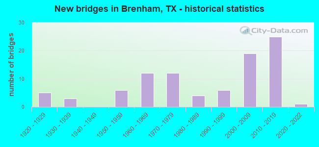
- New bridges - historical statistics
- 51920-1929
- 31930-1939
- 61950-1959
- 121960-1969
- 121970-1979
- 41980-1989
- 61990-1999
- 192000-2009
- 252010-2019
- 12020-2022

- Reconstructed bridges - Historical Statistics
- 41940-1949
- 01950-1959
- 41960-1969
- 11970-1979
- 21980-1989
- 11990-1999


- Bridge Condition - Deck
- 10.3%Very good
- 75.9%Good
- 12.1%Satisfactory
- 1.7%Fair

- Bridge Condition - Superstructure
- 22.4%Very good
- 37.9%Good
- 39.7%Satisfactory

- Bridge Condition - Substructure
- 8.6%Very good
- 48.3%Good
- 37.9%Satisfactory
- 3.4%Fair
- 1.7%Poor

- Bridge Condition - Channel
- 6.2%Very good
- 38.5%Good
- 44.6%Satisfactory
- 10.8%Fair

- Bridge Condition - Culverts
- 40.0%Good
- 45.0%Satisfactory
- 10.0%Fair
- 5.0%Poor
Find on map >> Show street view
Structure Number: 17239001140909, Location: 0.76 MI E OF SH 36 (Lat: 30.165183, Lng: -96.411319), Route carried "on" structure: Business State highway 290, Year Built: 1922, Year Reconstructed: 1947, Status: Open, Structure Length: 0.67m (2.20ft), Average Daily Traffic: 8,360 (year 2013), Truck Traffic: 5%, Average Future Daily Traffic: 11,700 (year 2033), Features Intersected: HIGGINS (HOG) BRANCH
Minimum Vertical Clearance: 30+ m (98+ ft), Kilometerpoint: 33.603, Lanes on structure: 2, Owner: State Highway Agency, Approaching Roadway Width: 10.4m (34.1ft), Material/Design: Concrete, Design/Construction: Slab, Number Of Spans In Main Unit: 1, Length of Maximum Span: 6.4m (21.0ft), Curb-To-Curb Width: 11.6m (38.1ft), Out-to-Out Width: 12.2m (40.0ft)
Condition: Deck: Very good, Superstructure: Satisfactory, Substructure: Good, Channel: Good, Operating Rating: 49.9 metric tons, Method Used To Determine Operating Rating: Load Factor (LF), Inventory Rating: 29.5 metric tons, Method Used To Determine Inventory Rating: Load Factor (LF), Structural Evaluation: Equal to present minimum criteria, Deck Geometry: Somewhat better than minimum adequacy, Waterway Adequacy: Equal to present minimum criteria, Approach Roadway Alignment: Equal to present desirable criteria, Designated Inspection Frequency: Every 24 months, Inspection Date: April 2021, Deck Structure Type: Concrete Cast-file-Place, Wearing Surface/Protective System: Wearing Surface: Bituminous
Find on map >> Show street view
Structure Number: 172390011410041, Location: 0.35 MI E OF FM 577 (Lat: 30.141211, Lng: -96.358544), Route carried "on" structure: US 290, Year Built: 1922, Year Reconstructed: 1952, Status: Open, Structure Length: 2.68m (8.79ft), Average Daily Traffic: 14,586 (year 2020), Truck Traffic: 11%, Average Future Daily Traffic: 14,420 (year 2033), Features Intersected: WOODWARD CREEK
Minimum Vertical Clearance: 30+ m (98+ ft), Kilometerpoint: 32.522, Lanes on structure: 2, Owner: State Highway Agency, Approaching Roadway Width: 11.0m (36.1ft), Material/Design: Concrete, Design/Construction: Slab, Number Of Spans In Main Unit: 4, Length of Maximum Span: 6.7m (22.0ft), Curb-To-Curb Width: 11.6m (38.1ft), Out-to-Out Width: 12.2m (40.0ft)
Condition: Deck: Good, Superstructure: Satisfactory, Substructure: Satisfactory, Channel: Good, Operating Rating: 47.2 metric tons, Method Used To Determine Operating Rating: Load Factor (LF), Inventory Rating: 28.1 metric tons, Method Used To Determine Inventory Rating: Load Factor (LF), Structural Evaluation: Equal to present minimum criteria, Deck Geometry: Better than present minimum criteria, Waterway Adequacy: Equal to present minimum criteria, Approach Roadway Alignment: Equal to present desirable criteria, Designated Inspection Frequency: Every 24 months, Inspection Date: April 2021, Deck Structure Type: Concrete Cast-file-Place, Wearing Surface/Protective System: Wearing Surface: Bituminous
Find on map >> Show street view
Structure Number: 172390011410095, Location: 0.35 MI E OF FM 577 (Lat: 30.141081, Lng: -96.359056), Route carried "on" structure: US 290, Year Built: 1963, Status: Open, Structure Length: 4.88m (16.01ft), Average Daily Traffic: 14,156 (year 2020), Truck Traffic: 11%, Average Future Daily Traffic: 14,420 (year 2033), Design Load: H 20, Features Intersected: WOODWARD CREEK
Minimum Vertical Clearance: 30+ m (98+ ft), Kilometerpoint: 32.510, Lanes on structure: 2, Owner: State Highway Agency, Approaching Roadway Width: 11.0m (36.1ft), Material/Design: Concrete, Design/Construction: Stringer/Multi-beam, Number Of Spans In Main Unit: 4, Length of Maximum Span: 12.2m (40.0ft), Curb-To-Curb Width: 11.0m (36.1ft), Out-to-Out Width: 12.2m (40.0ft)
Condition: Deck: Good, Superstructure: Satisfactory, Substructure: Good, Channel: Good, Operating Rating: 46.3 metric tons, Method Used To Determine Operating Rating: Load Factor (LF), Inventory Rating: 28.1 metric tons, Method Used To Determine Inventory Rating: Load Factor (LF), Structural Evaluation: Equal to present minimum criteria, Deck Geometry: Equal to present minimum criteria, Waterway Adequacy: Equal to present minimum criteria, Approach Roadway Alignment: Equal to present desirable criteria, Designated Inspection Frequency: Every 24 months, Inspection Date: April 2021, Deck Structure Type: Concrete Cast-file-Place, Wearing Surface/Protective System: Wearing Surface: Bituminous
Find on map >> Show street view
Structure Number: 172390011410125, Location: 0.53 MI S OF SH 105 (Lat: 30.159797, Lng: -96.394044), Route carried "on" structure: Business State highway 290, Year Built: 1977, Status: Open, Structure Length: 0.85m (2.79ft), Average Daily Traffic: 10,410 (year 2013), Truck Traffic: 4%, Average Future Daily Traffic: 14,570 (year 2033), Design Load: HS 20, Features Intersected: HOG BRANCH
Minimum Vertical Clearance: 30+ m (98+ ft), Kilometerpoint: 28.627, Lanes on structure: 3, Owner: State Highway Agency, Approaching Roadway Width: 12.5m (41.0ft), Material/Design: Concrete, Design/Construction: Culvert, Number Of Spans In Main Unit: 3, Length of Maximum Span: 2.7m (8.9ft), Curb or Sidewalk Widths: Left: 1.5m (4.9ft), Right: 1.5m (4.9ft), Curb-To-Curb Width: 12.8m (42.0ft), Out-to-Out Width: 16.5m (54.1ft)
Condition: Channel: Good, Culverts: Satisfactory, Operating Rating: 39.9 metric tons, Method Used To Determine Operating Rating: Load Factor (LF), Inventory Rating: 23.6 metric tons, Method Used To Determine Inventory Rating: Load Factor (LF), Structural Evaluation: Somewhat better than minimum adequacy, Deck Geometry: Meets minimum limits, Waterway Adequacy: Equal to present minimum criteria, Approach Roadway Alignment: Equal to present desirable criteria, Designated Inspection Frequency: Every 48 months, Inspection Date: April 2021, Deck Structure Type: Concrete Cast-file-Place, Wearing Surface/Protective System: Wearing Surface: Bituminous
Find on map >> Show street view
Structure Number: 172390018605022, Location: 4.5 MI SE OF FM 390 (Lat: 30.226647, Lng: -96.429706), Route carried "on" structure: State highway 36, Year Built: 1925, Year Reconstructed: 1994, Status: Open, Structure Length: 3.20m (10.50ft), Average Daily Traffic: 10,810 (year 2013), Truck Traffic: 21%, Average Future Daily Traffic: 15,140 (year 2033), Features Intersected: NEW YEARS CREEK
Minimum Vertical Clearance: 30+ m (98+ ft), Kilometerpoint: 13.538, Lanes on structure: 5, Owner: State Highway Agency, Approaching Roadway Width: 26.2m (86.0ft), Material/Design: Concrete, Design/Construction: Tee Beam, Number Of Spans In Main Unit: 3, Length of Maximum Span: 10.7m (35.1ft), Curb-To-Curb Width: 25.6m (84.0ft), Out-to-Out Width: 26.3m (86.3ft)
Condition: Deck: Good, Superstructure: Good, Substructure: Satisfactory, Channel: Good, Operating Rating: 50.8 metric tons, Method Used To Determine Operating Rating: Load Factor (LF), Inventory Rating: 29.9 metric tons, Method Used To Determine Inventory Rating: Load Factor (LF), Structural Evaluation: Equal to present minimum criteria, Deck Geometry: Superior to present desirable criteria, Waterway Adequacy: Superior to present desirable criteria, Approach Roadway Alignment: Equal to present desirable criteria, Designated Inspection Frequency: Every 24 months, Inspection Date: April 2021, Deck Structure Type: Concrete Cast-file-Place, Wearing Surface/Protective System: Wearing Surface: Bituminous
Find on map >> Show street view
Structure Number: 172390018605023, Location: 0.4 MI N OF BUS 36 (Lat: 30.201467, Lng: -96.412147), Route carried "on" structure: State highway 36, Year Built: 1925, Year Reconstructed: 1953, Status: Open, Structure Length: 4.33m (14.21ft), Average Daily Traffic: 10,810 (year 2013), Truck Traffic: 21%, Average Future Daily Traffic: 15,140 (year 2033), Features Intersected: BIG SANDY CREEK
Minimum Vertical Clearance: 30+ m (98+ ft), Kilometerpoint: 16.750, Lanes on structure: 2, Owner: State Highway Agency, Approaching Roadway Width: 12.2m (40.0ft), Material/Design: Concrete, Design/Construction: Tee Beam, Number Of Spans In Main Unit: 7, Length of Maximum Span: 6.1m (20.0ft), Curb-To-Curb Width: 12.3m (40.4ft), Out-to-Out Width: 12.8m (42.0ft)
Condition: Deck: Good, Superstructure: Good, Substructure: Good, Channel: Satisfactory, Operating Rating: 55.3 metric tons, Method Used To Determine Operating Rating: Load Factor (LF), Inventory Rating: 33.6 metric tons, Method Used To Determine Inventory Rating: Load Factor (LF), Structural Evaluation: Better than present minimum criteria, Deck Geometry: Better than present minimum criteria, Waterway Adequacy: Equal to present minimum criteria, Approach Roadway Alignment: Equal to present desirable criteria, Designated Inspection Frequency: Every 24 months, Inspection Date: April 2021, Deck Structure Type: Concrete Cast-file-Place, Wearing Surface/Protective System: Wearing Surface: Bituminous
Find on map >> Show street view
Structure Number: 172390018605024, Location: 0.8 MI N OF FM 577 (Lat: 30.186653, Lng: -96.404411), Route carried "on" structure: Business State highway 36, Year Built: 1925, Year Reconstructed: 1953, Status: Open, Structure Length: 3.08m (10.10ft), Average Daily Traffic: 5,980 (year 2013), Truck Traffic: 19%, Average Future Daily Traffic: 8,370 (year 2033), Features Intersected: LITTLE SANDY CREEK
Minimum Vertical Clearance: 30+ m (98+ ft), Kilometerpoint: 33.606, Lanes on structure: 2, Owner: State Highway Agency, Approaching Roadway Width: 12.2m (40.0ft), Material/Design: Concrete, Design/Construction: Slab, Number Of Spans In Main Unit: 5, Length of Maximum Span: 6.1m (20.0ft), Curb-To-Curb Width: 12.2m (40.0ft), Out-to-Out Width: 12.8m (42.0ft)
Condition: Deck: Very good, Superstructure: Good, Substructure: Satisfactory, Channel: Good, Operating Rating: 51.7 metric tons, Method Used To Determine Operating Rating: Load Factor (LF), Inventory Rating: 30.8 metric tons, Method Used To Determine Inventory Rating: Load Factor (LF), Structural Evaluation: Equal to present minimum criteria, Deck Geometry: Somewhat better than minimum adequacy, Waterway Adequacy: Equal to present minimum criteria, Approach Roadway Alignment: Equal to present desirable criteria, Designated Inspection Frequency: Every 24 months, Inspection Date: April 2021, Deck Structure Type: Concrete Cast-file-Place, Wearing Surface/Protective System: Wearing Surface: Bituminous
Find on map >> Show street view
Structure Number: 172390018605032, Location: 0.37 MI N OF BUS 290 (Lat: 30.172481, Lng: -96.399603), Route carried "on" structure: Business State highway 36, Year Built: 1957, Status: Open, Structure Length: 0.61m (2.00ft), Average Daily Traffic: 10,350 (year 2013), Truck Traffic: 21%, Average Future Daily Traffic: 14,490 (year 2033), Features Intersected: HIGGINS BRANCH
Minimum Vertical Clearance: 30+ m (98+ ft), Kilometerpoint: 35.237, Lanes on structure: 3, Owner: State Highway Agency, Approaching Roadway Width: 11.6m (38.1ft), Skew: 3 degrees, Material/Design: Concrete, Design/Construction: Culvert, Number Of Spans In Main Unit: 2, Length of Maximum Span: 2.4m (7.9ft), Curb or Sidewalk Widths: Left: 2.3m (7.5ft), Right: 0.0m, Curb-To-Curb Width: 14.6m (47.9ft), Out-to-Out Width: 23.9m (78.4ft)
Condition: Channel: Very good, Culverts: Satisfactory, Operating Rating: 39.9 metric tons, Method Used To Determine Operating Rating: Load Factor (LF), Inventory Rating: 23.6 metric tons, Method Used To Determine Inventory Rating: Load Factor (LF), Structural Evaluation: Somewhat better than minimum adequacy, Deck Geometry: Somewhat better than minimum adequacy, Waterway Adequacy: Equal to present minimum criteria, Approach Roadway Alignment: Equal to present desirable criteria, Designated Inspection Frequency: Every 24 months, Inspection Date: April 2021, Deck Structure Type: Concrete Cast-file-Place, Wearing Surface/Protective System: Wearing Surface: Bituminous
Find on map >> Show street view
Structure Number: 172390018605055, Location: 0.4 MI N OF BUS 36 (Lat: 30.201683, Lng: -96.412539), Route carried "on" structure: State highway 36, Year Built: 1995, Status: Open, Structure Length: 4.33m (14.21ft), Average Daily Traffic: 12,980 (year 2018), Truck Traffic: 21%, Average Future Daily Traffic: 15,140 (year 2033), Design Load: HS 20, Features Intersected: BIG SANDY CREEK
Minimum Vertical Clearance: 30+ m (98+ ft), Kilometerpoint: 16.753, Lanes on structure: 2, Owner: State Highway Agency, Approaching Roadway Width: 13.1m (43.0ft), Material/Design: Prestressed concrete, Design/Construction: Stringer/Multi-beam, Number Of Spans In Main Unit: 1, Number Of Approach Spans: 2, Length of Maximum Span: 18.3m (60.0ft), Curb-To-Curb Width: 13.0m (42.7ft), Out-to-Out Width: 13.4m (44.0ft)
Condition: Deck: Very good, Superstructure: Good, Substructure: Good, Channel: Satisfactory, Operating Rating: 54.4 metric tons, Method Used To Determine Operating Rating: Assigned rating based on Load Factor Design (LFD) reported in metric tons, Inventory Rating: 32.7 metric tons, Method Used To Determine Inventory Rating: Assigned rating based on Load Factor Design (LFD) reported in metric tons, Structural Evaluation: Better than present minimum criteria, Deck Geometry: Superior to present desirable criteria, Waterway Adequacy: Equal to present minimum criteria, Approach Roadway Alignment: Equal to present desirable criteria, Designated Inspection Frequency: Every 24 months, Inspection Date: April 2021, Deck Structure Type: Concrete Precast Panels, Wearing Surface/Protective System: Wearing Surface: Bituminous
Find on map >> Show street view
Structure Number: 172390018606043, Location: 0.3 MI S OF BUS290 (Lat: 30.162094, Lng: -96.422919), Route carried "on" structure: County highway 103, Year Built: 1958, Status: Open, Structure Length: 4.88m (16.01ft), Average Daily Traffic: 1,250 (year 2008), Truck Traffic: 1%, Average Future Daily Traffic: 1,200 (year 2028), Design Load: H 20, Features Intersected: US 290, Facility Carried by Structure: OLD MILL CREEK RD
Minimum Vertical Clearance: 8.82m (28.94ft), Kilometerpoint: 25.347, Lanes on structure: 2, Lanes under structure: 4, Owner: State Highway Agency, Approaching Roadway Width: 6.1m (20.0ft), Material/Design: Prestressed concrete, Design/Construction: Stringer/Multi-beam, Number Of Spans In Main Unit: 4, Length of Maximum Span: 13.4m (44.0ft), Curb-To-Curb Width: 8.4m (27.6ft), Out-to-Out Width: 9.1m (29.9ft)
Condition: Deck: Satisfactory, Superstructure: Very good, Substructure: Good, Operating Rating: 68.0 metric tons, Method Used To Determine Operating Rating: Load Factor (LF), Inventory Rating: 39.0 metric tons, Method Used To Determine Inventory Rating: Load Factor (LF), Structural Evaluation: Better than present minimum criteria, Deck Geometry: Meets minimum limits, Underclear: Somewhat better than minimum adequacy, Approach Roadway Alignment: Equal to present desirable criteria, Designated Inspection Frequency: Every 24 months, Inspection Date: April 2021, Deck Structure Type: Concrete Cast-file-Place
Find on map >> Show street view
Structure Number: 172390018606044, Location: 0.28 MI SE OF FM 389 (Lat: 30.148058, Lng: -96.407706), Route carried "on" structure: US 290, Year Built: 1958, Status: Open, Structure Length: 9.63m (31.59ft), Average Daily Traffic: 8,220 (year 2013), Truck Traffic: 16%, Average Future Daily Traffic: 11,510 (year 2033), Design Load: H 20, Features Intersected: BNSF RR
Minimum Vertical Clearance: 30+ m (98+ ft), Kilometerpoint: 27.525, Lanes on structure: 2, Base Highway Network: Yes (Inventory Route: SH360000, Subroute: 2), Owner: State Highway Agency, Approaching Roadway Width: 9.1m (29.9ft), Skew: 3 degrees, Material/Design: Steel continuous, Design/Construction: Stringer/Multi-beam, Number Of Spans In Main Unit: 5, Length of Maximum Span: 21.3m (69.9ft), Curb-To-Curb Width: 9.1m (29.9ft), Out-to-Out Width: 10.1m (33.1ft)
Condition: Deck: Satisfactory, Superstructure: Good, Substructure: Good, Operating Rating: 39.9 metric tons, Method Used To Determine Operating Rating: Load Factor (LF), Inventory Rating: 24.5 metric tons, Method Used To Determine Inventory Rating: Load Factor (LF), Structural Evaluation: Equal to present minimum criteria, Deck Geometry: Meets minimum limits, Underclear: High priority of corrective action, Approach Roadway Alignment: Equal to present desirable criteria, Designated Inspection Frequency: Every 24 months, Inspection Date: April 2021, Deck Structure Type: Concrete Cast-file-Place, Wearing Surface/Protective System: Wearing Surface: Bituminous
Find on map >> Show street view
Structure Number: 172390018606045, Location: 0.29 MI SE OF FM 389 (Lat: 30.147897, Lng: -96.407881), Route carried "on" structure: US 290, Year Built: 1958, Year Reconstructed: 1971, Status: Open, Structure Length: 9.63m (31.59ft), Average Daily Traffic: 8,220 (year 2013), Truck Traffic: 16%, Average Future Daily Traffic: 11,510 (year 2033), Design Load: H 20, Features Intersected: BNSF RR
Minimum Vertical Clearance: 30+ m (98+ ft), Kilometerpoint: 27.554, Lanes on structure: 3, Base Highway Network: Yes (Inventory Route: SH360000, Subroute: 2), Owner: State Highway Agency, Approaching Roadway Width: 12.8m (42.0ft), Skew: 3 degrees, Material/Design: Steel continuous, Design/Construction: Stringer/Multi-beam, Number Of Spans In Main Unit: 5, Length of Maximum Span: 21.3m (69.9ft), Curb-To-Curb Width: 13.1m (43.0ft), Out-to-Out Width: 14.1m (46.3ft)
Condition: Deck: Satisfactory, Superstructure: Good, Substructure: Good, Operating Rating: 39.9 metric tons, Method Used To Determine Operating Rating: Load Factor (LF), Inventory Rating: 24.5 metric tons, Method Used To Determine Inventory Rating: Load Factor (LF), Structural Evaluation: Equal to present minimum criteria, Deck Geometry: Meets minimum limits, Underclear: High priority of corrective action, Approach Roadway Alignment: Equal to present desirable criteria, Designated Inspection Frequency: Every 24 months, Inspection Date: April 2021, Deck Structure Type: Concrete Cast-file-Place, Wearing Surface/Protective System: Wearing Surface: Bituminous
Find on map >> Show street view
Structure Number: 172390018606049, Location: 1.09 MI SE OF FM 389 (Lat: 30.142678, Lng: -96.396053), Route carried "on" structure: US 290, Year Built: 1963, Status: Open, Structure Length: 5.55m (18.21ft), Average Daily Traffic: 8,220 (year 2013), Truck Traffic: 16%, Average Future Daily Traffic: 11,510 (year 2033), Design Load: H 20, Features Intersected: SH 36
Minimum Vertical Clearance: 30+ m (98+ ft), Kilometerpoint: 28.846, Lanes on structure: 2, Lanes under structure: 8, Owner: State Highway Agency, Approaching Roadway Width: 11.0m (36.1ft), Material/Design: Prestressed concrete, Design/Construction: Stringer/Multi-beam, Number Of Spans In Main Unit: 4, Length of Maximum Span: 13.7m (44.9ft), Curb-To-Curb Width: 11.3m (37.1ft), Out-to-Out Width: 12.3m (40.4ft)
Condition: Deck: Good, Superstructure: Very good, Substructure: Good, Operating Rating: 61.7 metric tons, Method Used To Determine Operating Rating: Load Factor (LF), Inventory Rating: 37.2 metric tons, Method Used To Determine Inventory Rating: Load Factor (LF), Structural Evaluation: Better than present minimum criteria, Deck Geometry: Equal to present minimum criteria, Underclear: High priority of corrective action, Approach Roadway Alignment: Equal to present desirable criteria, Designated Inspection Frequency: Every 24 months, Inspection Date: April 2021, Deck Structure Type: Concrete Cast-file-Place, Wearing Surface/Protective System: Wearing Surface: Bituminous
Find on map >> Show street view
Structure Number: 17239001860605, Location: 1.09 MI SE OF FM 389 (Lat: 30.142489, Lng: -96.396036), Route carried "on" structure: US 290, Year Built: 1963, Status: Open, Structure Length: 5.55m (18.21ft), Average Daily Traffic: 8,220 (year 2013), Truck Traffic: 16%, Average Future Daily Traffic: 11,510 (year 2033), Design Load: H 20, Features Intersected: SH 36
Minimum Vertical Clearance: 30+ m (98+ ft), Kilometerpoint: 28.847, Lanes on structure: 2, Lanes under structure: 8, Owner: State Highway Agency, Approaching Roadway Width: 11.0m (36.1ft), Material/Design: Prestressed concrete, Design/Construction: Stringer/Multi-beam, Number Of Spans In Main Unit: 4, Length of Maximum Span: 13.7m (44.9ft), Curb-To-Curb Width: 11.3m (37.1ft), Out-to-Out Width: 12.3m (40.4ft)
Condition: Deck: Very good, Superstructure: Good, Substructure: Good, Operating Rating: 61.7 metric tons, Method Used To Determine Operating Rating: Load Factor (LF), Inventory Rating: 36.3 metric tons, Method Used To Determine Inventory Rating: Load Factor (LF), Structural Evaluation: Better than present minimum criteria, Deck Geometry: Equal to present minimum criteria, Underclear: High priority of corrective action, Approach Roadway Alignment: Equal to present desirable criteria, Designated Inspection Frequency: Every 24 months, Inspection Date: April 2021, Deck Structure Type: Concrete Cast-file-Place, Wearing Surface/Protective System: Wearing Surface: Bituminous
Find on map >> Show street view
Structure Number: 172390018606063, Location: 1.08 MI NW OF SH 36 (Lat: 30.150231, Lng: -96.411606), Route carried "on" structure: State highway 389, Year Built: 1971, Status: Open, Structure Length: 5.49m (18.01ft), Average Daily Traffic: 4,880 (year 2013), Truck Traffic: 15%, Average Future Daily Traffic: 6,830 (year 2033), Design Load: HS 20, Features Intersected: US 290
Minimum Vertical Clearance: 5.11m (16.77ft), Kilometerpoint: 19.071, Lanes on structure: 2, Lanes under structure: 4, Owner: State Highway Agency, Approaching Roadway Width: 17.7m (58.1ft), Skew: 3 degrees, Material/Design: Prestressed concrete, Design/Construction: Stringer/Multi-beam, Number Of Spans In Main Unit: 2, Length of Maximum Span: 27.4m (89.9ft), Curb-To-Curb Width: 17.1m (56.1ft), Out-to-Out Width: 17.8m (58.4ft)
Condition: Deck: Good, Superstructure: Good, Substructure: Satisfactory, Operating Rating: 54.4 metric tons, Method Used To Determine Operating Rating: Assigned ratings based on Load and Resistance Factor Design (LRFD) reported in metric tons, Inventory Rating: 32.7 metric tons, Method Used To Determine Inventory Rating: Assigned ratings based on Load and Resistance Factor Design (LRFD) reported in metric tons, Structural Evaluation: Equal to present minimum criteria, Deck Geometry: Superior to present desirable criteria, Underclear: Better than present minimum criteria, Approach Roadway Alignment: Equal to present desirable criteria, Designated Inspection Frequency: Every 24 months, Inspection Date: April 2021, Deck Structure Type: Concrete Cast-file-Place
Find on map >> Show street view
Structure Number: 172390018606099, Location: 1.4 MI NW OF FM 389 (Lat: 30.166178, Lng: -96.423967), Route carried "on" structure: Business State highway 290, Year Built: 1964, Status: Open, Structure Length: 6.16m (20.21ft), Average Daily Traffic: 8,360 (year 2013), Truck Traffic: 5%, Average Future Daily Traffic: 11,700 (year 2033), Design Load: H 20, Features Intersected: US 290 WB & SH 36
Minimum Vertical Clearance: 30+ m (98+ ft), Kilometerpoint: 32.348, Lanes on structure: 2, Lanes under structure: 4, Owner: State Highway Agency, Approaching Roadway Width: 11.6m (38.1ft), Skew: 1 degrees, Material/Design: Prestressed concrete, Design/Construction: Stringer/Multi-beam, Number Of Spans In Main Unit: 4, Length of Maximum Span: 16.8m (55.1ft), Curb-To-Curb Width: 11.6m (38.1ft), Out-to-Out Width: 12.7m (41.7ft)
Condition: Deck: Good, Superstructure: Good, Substructure: Good, Operating Rating: 68.0 metric tons, Method Used To Determine Operating Rating: Load Factor (LF), Inventory Rating: 38.1 metric tons, Method Used To Determine Inventory Rating: Load Factor (LF), Structural Evaluation: Better than present minimum criteria, Deck Geometry: Better than present minimum criteria, Underclear: Meets minimum limits, Approach Roadway Alignment: Equal to present desirable criteria, Designated Inspection Frequency: Every 24 months, Inspection Date: April 2021, Deck Structure Type: Concrete Cast-file-Place
Find on map >> Show street view
Structure Number: 172390018606187, Location: 1.4 MI NW OF FM 389 (Lat: 30.166258, Lng: -96.424317), Route carried "on" structure: Business State highway 290, Year Built: 1964, Status: Open, Structure Length: 6.16m (20.21ft), Average Daily Traffic: 7,200 (year 2010), Truck Traffic: 8%, Average Future Daily Traffic: 10,080 (year 2030), Design Load: H 20, Features Intersected: US 290 WB AND SH 36
Minimum Vertical Clearance: 30+ m (98+ ft), Kilometerpoint: 17.650, Lanes on structure: 3, Lanes under structure: 4, Owner: State Highway Agency, Approaching Roadway Width: 11.6m (38.1ft), Skew: 1 degrees, Material/Design: Prestressed concrete, Design/Construction: Stringer/Multi-beam, Number Of Spans In Main Unit: 4, Length of Maximum Span: 16.8m (55.1ft), Curb-To-Curb Width: 11.6m (38.1ft), Out-to-Out Width: 12.7m (41.7ft)
Condition: Deck: Satisfactory, Superstructure: Very good, Substructure: Good, Operating Rating: 68.0 metric tons, Method Used To Determine Operating Rating: Load Factor (LF), Inventory Rating: 38.1 metric tons, Method Used To Determine Inventory Rating: Load Factor (LF), Structural Evaluation: Better than present minimum criteria, Deck Geometry: High priority of replacement, Underclear: Meets minimum limits, Approach Roadway Alignment: Equal to present desirable criteria, Length Of Structure Improvement: 6.16m (20.21ft), Designated Inspection Frequency: Every 24 months, Inspection Date: April 2021, Bridge Improvement Cost: $15,000, Roadway Improvement Cost: $4,000, Total Project Cost: $19,000, Deck Structure Type: Concrete Cast-file-Place
Find on map >> Show street view
Structure Number: 172390018606188, Location: 1.61 MI E OF SH 36 (Lat: 30.143292, Lng: -96.368858), Route carried "on" structure: US 290, Year Built: 2012, Status: Open, Structure Length: 9.30m (30.51ft), Average Daily Traffic: 23,866 (year 2020), Truck Traffic: 9%, Average Future Daily Traffic: 24,920 (year 2033), Design Load: HL 93, Features Intersected: BU 290
Minimum Vertical Clearance: 30+ m (98+ ft), Kilometerpoint: 47.846, Lanes on structure: 6, Lanes under structure: 7, Owner: State Highway Agency, Approaching Roadway Width: 34.4m (112.9ft), Skew: 30 degrees, Material/Design: Prestressed concrete, Design/Construction: Stringer/Multi-beam, Number Of Spans In Main Unit: 1, Number Of Approach Spans: 2, Length of Maximum Span: 38.1m (125.0ft), Curb-To-Curb Width: 34.5m (113.2ft), Out-to-Out Width: 36.0m (118.1ft)
Condition: Deck: Good, Superstructure: Very good, Substructure: Good, Operating Rating: 54.4 metric tons, Method Used To Determine Operating Rating: Assigned ratings based on Load and Resistance Factor Design (LRFD) reported in metric tons, Inventory Rating: 32.7 metric tons, Method Used To Determine Inventory Rating: Assigned ratings based on Load and Resistance Factor Design (LRFD) reported in metric tons, Structural Evaluation: Better than present minimum criteria, Deck Geometry: Superior to present desirable criteria, Underclear: Equal to present minimum criteria, Approach Roadway Alignment: Equal to present desirable criteria, Designated Inspection Frequency: Every 24 months, Inspection Date: April 2021, Deck Structure Type: Concrete Precast Panels
Find on map >> Show street view
Structure Number: 172390018606189, Location: 1.91 MI E OF SH 36 (Lat: 30.143192, Lng: -96.363792), Route carried "on" structure: US 290, Year Built: 2012, Status: Open, Structure Length: 9.30m (30.51ft), Average Daily Traffic: 23,866 (year 2020), Truck Traffic: 9%, Average Future Daily Traffic: 24,920 (year 2033), Design Load: HL 93, Features Intersected: FM 577
Minimum Vertical Clearance: 30+ m (98+ ft), Kilometerpoint: 48.055, Lanes on structure: 4, Lanes under structure: 8, Owner: State Highway Agency, Approaching Roadway Width: 27.1m (88.9ft), Skew: 30 degrees, Material/Design: Prestressed concrete, Design/Construction: Stringer/Multi-beam, Number Of Spans In Main Unit: 1, Number Of Approach Spans: 2, Length of Maximum Span: 38.1m (125.0ft), Curb-To-Curb Width: 27.2m (89.2ft), Out-to-Out Width: 28.7m (94.2ft)
Condition: Deck: Good, Superstructure: Very good, Substructure: Good, Operating Rating: 54.4 metric tons, Method Used To Determine Operating Rating: Assigned ratings based on Load and Resistance Factor Design (LRFD) reported in metric tons, Inventory Rating: 32.7 metric tons, Method Used To Determine Inventory Rating: Assigned ratings based on Load and Resistance Factor Design (LRFD) reported in metric tons, Structural Evaluation: Better than present minimum criteria, Deck Geometry: Superior to present desirable criteria, Underclear: Equal to present minimum criteria, Approach Roadway Alignment: Equal to present desirable criteria, Designated Inspection Frequency: Every 24 months, Inspection Date: April 2021, Deck Structure Type: Concrete Precast Panels
Find on map >> Show street view
Structure Number: 17239001860619, Location: 0.87 MI E OF SH 36 (Lat: 30.142492, Lng: -96.381331), Route carried "on" structure: US 290, Year Built: 2012, Status: Open, Structure Length: 9.30m (30.51ft), Average Daily Traffic: 23,866 (year 2020), Truck Traffic: 9%, Average Future Daily Traffic: 24,920 (year 2033), Design Load: HL 93, Features Intersected: STRINGER ST
Minimum Vertical Clearance: 30+ m (98+ ft), Kilometerpoint: 46.574, Lanes on structure: 4, Lanes under structure: 5, Owner: State Highway Agency, Approaching Roadway Width: 34.4m (112.9ft), Skew: 30 degrees, Material/Design: Prestressed concrete, Design/Construction: Stringer/Multi-beam, Number Of Spans In Main Unit: 1, Number Of Approach Spans: 2, Length of Maximum Span: 38.1m (125.0ft), Curb-To-Curb Width: 34.5m (113.2ft), Out-to-Out Width: 36.0m (118.1ft)
Condition: Deck: Good, Superstructure: Very good, Substructure: Good, Operating Rating: 54.4 metric tons, Method Used To Determine Operating Rating: Assigned ratings based on Load and Resistance Factor Design (LRFD) reported in metric tons, Inventory Rating: 32.7 metric tons, Method Used To Determine Inventory Rating: Assigned ratings based on Load and Resistance Factor Design (LRFD) reported in metric tons, Structural Evaluation: Better than present minimum criteria, Deck Geometry: Superior to present desirable criteria, Underclear: Superior to present desirable criteria, Approach Roadway Alignment: Equal to present desirable criteria, Designated Inspection Frequency: Every 24 months, Inspection Date: April 2021, Deck Structure Type: Concrete Precast Panels
Find on map >> Show street view
Structure Number: 172390018606191, Location: 0.65 MI N OF FM 577 (Lat: 30.188192, Lng: -96.412131), Route carried "on" structure: State highway 36, Year Built: 2018, Status: Open, Structure Length: 15.88m (52.10ft), Average Daily Traffic: 12,700 (year 2014), Truck Traffic: 15%, Average Future Daily Traffic: 15,000 (year 2034), Design Load: HL 93, Features Intersected: BNSF/CITY STREETS/CREEK
Minimum Vertical Clearance: 30+ m (98+ ft), Kilometerpoint: 18.837, Lanes on structure: 2, Lanes under structure: 5, Owner: State Highway Agency, Approaching Roadway Width: 12.2m (40.0ft), Material/Design: Prestressed concrete, Design/Construction: Stringer/Multi-beam, Number Of Spans In Main Unit: 5, Length of Maximum Span: 35.7m (117.1ft), Curb-To-Curb Width: 11.5m (37.7ft), Out-to-Out Width: 12.2m (40.0ft)
Condition: Deck: Good, Superstructure: Very good, Substructure: Good, Channel: Good, Operating Rating: 54.4 metric tons, Method Used To Determine Operating Rating: Assigned ratings based on Load and Resistance Factor Design (LRFD) reported in metric tons, Inventory Rating: 32.7 metric tons, Method Used To Determine Inventory Rating: Assigned ratings based on Load and Resistance Factor Design (LRFD) reported in metric tons, Structural Evaluation: Better than present minimum criteria, Deck Geometry: Equal to present minimum criteria, Underclear: Meets minimum limits, Waterway Adequacy: Superior to present desirable criteria, Approach Roadway Alignment: Equal to present desirable criteria, Designated Inspection Frequency: Every 24 months, Inspection Date: April 2021, Deck Structure Type: Concrete Precast Panels
Find on map >> Show street view
Structure Number: 172390018606192, Location: 0.65 MI N OF FM 577 (Lat: 30.188489, Lng: -96.412175), Route carried "on" structure: State highway 36, Year Built: 2017, Status: Open, Structure Length: 15.39m (50.49ft), Average Daily Traffic: 12,700 (year 2014), Truck Traffic: 15%, Average Future Daily Traffic: 15,000 (year 2034), Design Load: HL 93, Features Intersected: BNSF/CITY STREETS/CREEK
Minimum Vertical Clearance: 30+ m (98+ ft), Kilometerpoint: 18.837, Lanes on structure: 2, Lanes under structure: 5, Owner: State Highway Agency, Approaching Roadway Width: 11.6m (38.1ft), Material/Design: Prestressed concrete, Design/Construction: Stringer/Multi-beam, Number Of Spans In Main Unit: 5, Length of Maximum Span: 33.2m (108.9ft), Curb-To-Curb Width: 11.5m (37.7ft), Out-to-Out Width: 12.2m (40.0ft)
Condition: Deck: Good, Superstructure: Very good, Substructure: Satisfactory, Channel: Good, Operating Rating: 54.4 metric tons, Method Used To Determine Operating Rating: Assigned ratings based on Load and Resistance Factor Design (LRFD) reported in metric tons, Inventory Rating: 32.7 metric tons, Method Used To Determine Inventory Rating: Assigned ratings based on Load and Resistance Factor Design (LRFD) reported in metric tons, Structural Evaluation: Equal to present minimum criteria, Deck Geometry: Equal to present minimum criteria, Underclear: Meets minimum limits, Waterway Adequacy: Superior to present desirable criteria, Approach Roadway Alignment: Equal to present desirable criteria, Designated Inspection Frequency: Every 24 months, Inspection Date: April 2021, Deck Structure Type: Concrete Cast-file-Place
Find on map >> Show street view
Structure Number: 172390018701027, Location: 0.55 MI S OF SH 105 (Lat: 30.158672, Lng: -96.397844), Route carried "on" structure: Business State highway 36, Year Built: 1977, Status: Open, Structure Length: 0.76m (2.49ft), Average Daily Traffic: 11,370 (year 2013), Truck Traffic: 21%, Average Future Daily Traffic: 15,920 (year 2033), Design Load: HS 20, Features Intersected: HOG BRANCH
Minimum Vertical Clearance: 30+ m (98+ ft), Kilometerpoint: 0.882, Lanes on structure: 3, Owner: State Highway Agency, Approaching Roadway Width: 13.4m (44.0ft), Material/Design: Concrete, Design/Construction: Culvert, Number Of Spans In Main Unit: 3, Length of Maximum Span: 2.4m (7.9ft), Curb or Sidewalk Widths: Left: 2.4m (7.9ft), Right: 2.4m (7.9ft), Curb-To-Curb Width: 13.4m (44.0ft), Out-to-Out Width: 18.9m (62.0ft)
Condition: Channel: Good, Culverts: Good, Operating Rating: 39.9 metric tons, Method Used To Determine Operating Rating: Load Factor (LF), Inventory Rating: 23.6 metric tons, Method Used To Determine Inventory Rating: Load Factor (LF), Structural Evaluation: Somewhat better than minimum adequacy, Deck Geometry: Somewhat better than minimum adequacy, Waterway Adequacy: Equal to present minimum criteria, Approach Roadway Alignment: Equal to present desirable criteria, Designated Inspection Frequency: Every 48 months, Inspection Date: April 2021, Deck Structure Type: Concrete Cast-file-Place, Wearing Surface/Protective System: Wearing Surface: Bituminous
Find on map >> Show street view
Structure Number: 172390031507071, Location: 0.56 MI NE OF FM 577 (Lat: 30.184347, Lng: -96.377994), Route carried "on" structure: State highway 105, Year Built: 2000, Status: Open, Structure Length: 5.49m (18.01ft), Average Daily Traffic: 11,055 (year 2020), Truck Traffic: 5%, Average Future Daily Traffic: 15,800 (year 2033), Design Load: HS 20, Features Intersected: LITTLE SANDY CREEK
Minimum Vertical Clearance: 30+ m (98+ ft), Kilometerpoint: 23.879, Lanes on structure: 5, Owner: State Highway Agency, Approaching Roadway Width: 25.0m (82.0ft), Material/Design: Prestressed concrete, Design/Construction: Stringer/Multi-beam, Number Of Spans In Main Unit: 3, Length of Maximum Span: 18.3m (60.0ft), Curb-To-Curb Width: 25.6m (84.0ft), Out-to-Out Width: 26.2m (86.0ft)
Condition: Deck: Good, Superstructure: Very good, Substructure: Satisfactory, Channel: Fair, Operating Rating: 54.4 metric tons, Method Used To Determine Operating Rating: Assigned rating based on Load Factor Design (LFD) reported in metric tons, Inventory Rating: 32.7 metric tons, Method Used To Determine Inventory Rating: Assigned rating based on Load Factor Design (LFD) reported in metric tons, Structural Evaluation: Equal to present minimum criteria, Deck Geometry: Superior to present desirable criteria, Waterway Adequacy: Superior to present desirable criteria, Approach Roadway Alignment: Equal to present desirable criteria, Designated Inspection Frequency: Every 24 months, Inspection Date: April 2021, Deck Structure Type: Concrete Precast Panels
Find on map >> Show street view
Structure Number: 172390031507072, Location: 0.1 MI W OF FM 50 (Lat: 30.196350, Lng: -96.365156), Route carried "on" structure: State highway 105, Year Built: 2000, Status: Open, Structure Length: 14.63m (48.00ft), Average Daily Traffic: 9,935 (year 2020), Truck Traffic: 12%, Average Future Daily Traffic: 13,020 (year 2033), Design Load: HS 20, Features Intersected: NEW YEARS CREEK
Minimum Vertical Clearance: 30+ m (98+ ft), Kilometerpoint: 25.698, Lanes on structure: 5, Owner: State Highway Agency, Approaching Roadway Width: 25.6m (84.0ft), Material/Design: Prestressed concrete, Design/Construction: Stringer/Multi-beam, Number Of Spans In Main Unit: 6, Length of Maximum Span: 24.4m (80.1ft), Curb-To-Curb Width: 25.6m (84.0ft), Out-to-Out Width: 26.2m (86.0ft)
Condition: Deck: Good, Superstructure: Good, Substructure: Good, Channel: Good, Operating Rating: 54.4 metric tons, Method Used To Determine Operating Rating: Assigned rating based on Load Factor Design (LFD) reported in metric tons, Inventory Rating: 32.7 metric tons, Method Used To Determine Inventory Rating: Assigned rating based on Load Factor Design (LFD) reported in metric tons, Structural Evaluation: Better than present minimum criteria, Deck Geometry: Superior to present desirable criteria, Waterway Adequacy: Superior to present desirable criteria, Approach Roadway Alignment: Equal to present desirable criteria, Designated Inspection Frequency: Every 24 months, Inspection Date: April 2021, Deck Structure Type: Concrete Precast Panels
Find on map >> Show street view
Structure Number: 172390031507073, Location: 0.33 MI SW OF FM 50 (Lat: 30.193539, Lng: -96.367975), Route carried "on" structure: State highway 105, Year Built: 2000, Status: Open, Structure Length: 1.37m (4.49ft), Average Daily Traffic: 9,935 (year 2020), Truck Traffic: 12%, Average Future Daily Traffic: 13,020 (year 2033), Design Load: HS 20, Features Intersected: NEW YEARS CREEK REL
Minimum Vertical Clearance: 30+ m (98+ ft), Kilometerpoint: 25.300, Lanes on structure: 5, Owner: State Highway Agency, Approaching Roadway Width: 26.2m (86.0ft), Material/Design: Concrete, Design/Construction: Culvert, Number Of Spans In Main Unit: 6, Length of Maximum Span: 1.8m (5.9ft)
Condition: Channel: Good, Culverts: Good, Operating Rating: 54.4 metric tons, Method Used To Determine Operating Rating: Assigned rating based on Load Factor Design (LFD) reported in metric tons, Inventory Rating: 32.7 metric tons, Method Used To Determine Inventory Rating: Assigned rating based on Load Factor Design (LFD) reported in metric tons, Structural Evaluation: Better than present minimum criteria, Waterway Adequacy: Equal to present desirable criteria, Approach Roadway Alignment: Equal to present desirable criteria, Designated Inspection Frequency: Every 48 months, Inspection Date: April 2021
Find on map >> Show street view
Structure Number: 172390031507076, Location: 0.37 MI E OF FM 50 (Lat: 30.200639, Lng: -96.360219), Route carried "on" structure: State highway 105, Year Built: 2000, Status: Open, Structure Length: 0.88m (2.89ft), Average Daily Traffic: 8,054 (year 2020), Truck Traffic: 12%, Average Future Daily Traffic: 8,680 (year 2033), Design Load: HS 20, Features Intersected: DRAW
Minimum Vertical Clearance: 30+ m (98+ ft), Kilometerpoint: 26.437, Lanes on structure: 2, Owner: State Highway Agency, Approaching Roadway Width: 16.5m (54.1ft), Skew: 4 degrees, Material/Design: Concrete, Design/Construction: Culvert, Number Of Spans In Main Unit: 3, Length of Maximum Span: 1.8m (5.9ft)
Condition: Channel: Satisfactory, Culverts: Satisfactory, Operating Rating: 54.4 metric tons, Method Used To Determine Operating Rating: Assigned rating based on Load Factor Design (LFD) reported in metric tons, Inventory Rating: 32.7 metric tons, Method Used To Determine Inventory Rating: Assigned rating based on Load Factor Design (LFD) reported in metric tons, Structural Evaluation: Equal to present minimum criteria, Waterway Adequacy: Equal to present minimum criteria, Approach Roadway Alignment: Equal to present desirable criteria, Designated Inspection Frequency: Every 48 months, Inspection Date: April 2021
Find on map >> Show street view
Structure Number: 172390031507077, Location: 0.85 MI NE OF FM 577 (Lat: 30.187103, Lng: -96.374808), Route carried "on" structure: State highway 105, Year Built: 2000, Status: Open, Structure Length: 0.67m (2.20ft), Average Daily Traffic: 9,935 (year 2020), Truck Traffic: 12%, Average Future Daily Traffic: 13,020 (year 2033), Design Load: HS 20, Features Intersected: DRAW
Minimum Vertical Clearance: 30+ m (98+ ft), Kilometerpoint: 24.320, Lanes on structure: 5, Owner: State Highway Agency, Approaching Roadway Width: 25.6m (84.0ft), Material/Design: Concrete, Design/Construction: Culvert, Number Of Spans In Main Unit: 3, Length of Maximum Span: 1.8m (5.9ft)
Condition: Channel: Good, Culverts: Satisfactory, Operating Rating: 54.4 metric tons, Method Used To Determine Operating Rating: Assigned rating based on Load Factor Design (LFD) reported in metric tons, Inventory Rating: 32.7 metric tons, Method Used To Determine Inventory Rating: Assigned rating based on Load Factor Design (LFD) reported in metric tons, Structural Evaluation: Equal to present minimum criteria, Waterway Adequacy: Equal to present minimum criteria, Approach Roadway Alignment: Equal to present desirable criteria, Designated Inspection Frequency: Every 48 months, Inspection Date: April 2021
Find on map >> Show street view
Structure Number: 172390031508016, Location: 3.85 MI SW OF US 290 (Lat: 30.132764, Lng: -96.469875), Route carried "on" structure: State highway 389, Year Built: 1930, Year Reconstructed: 1966, Status: Open, Structure Length: 2.74m (8.99ft), Average Daily Traffic: 1,560 (year 2013), Truck Traffic: 5%, Average Future Daily Traffic: 2,190 (year 2033), Features Intersected: SANDY CREEK
Minimum Vertical Clearance: 30+ m (98+ ft), Kilometerpoint: 13.021, Lanes on structure: 2, Owner: State Highway Agency, Approaching Roadway Width: 7.0m (23.0ft), Skew: 4 degrees, Material/Design: Concrete, Design/Construction: Tee Beam, Number Of Spans In Main Unit: 4, Length of Maximum Span: 7.0m (23.0ft), Curb-To-Curb Width: 7.9m (25.9ft), Out-to-Out Width: 8.6m (28.2ft)
Condition: Deck: Good, Superstructure: Satisfactory, Substructure: Good, Channel: Satisfactory, Operating Rating: 40.8 metric tons, Method Used To Determine Operating Rating: Field evaluation and documented engineering judgment, Inventory Rating: 24.5 metric tons, Method Used To Determine Inventory Rating: Field evaluation and documented engineering judgment, Structural Evaluation: Equal to present minimum criteria, Deck Geometry: Meets minimum limits, Waterway Adequacy: Equal to present minimum criteria, Approach Roadway Alignment: Equal to present desirable criteria, Length Of Structure Improvement: 2.74m (8.99ft), Designated Inspection Frequency: Every 24 months, Inspection Date: April 2021, Bridge Improvement Cost: $5,000, Roadway Improvement Cost: $1,000, Total Project Cost: $6,000, Deck Structure Type: Concrete Cast-file-Place, Wearing Surface/Protective System: Wearing Surface: Bituminous
Find on map >> Show street view
Structure Number: 172390031508017, Location: 2.5 MI W OF US 290 (Lat: 30.143072, Lng: -96.452572), Route carried "on" structure: State highway 389, Year Built: 1930, Year Reconstructed: 1966, Status: Open, Structure Length: 1.25m (4.10ft), Average Daily Traffic: 2,627 (year 2020), Truck Traffic: 5%, Average Future Daily Traffic: 3,580 (year 2033), Features Intersected: WOOD BRANCH
Minimum Vertical Clearance: 30+ m (98+ ft), Kilometerpoint: 15.115, Lanes on structure: 2, Owner: State Highway Agency, Approaching Roadway Width: 7.3m (24.0ft), Skew: 3 degrees, Material/Design: Concrete, Design/Construction: Culvert, Number Of Spans In Main Unit: 4, Length of Maximum Span: 2.4m (7.9ft), Curb-To-Curb Width: 7.9m (25.9ft), Out-to-Out Width: 8.6m (28.2ft)
Condition: Channel: Satisfactory, Culverts: Fair, Operating Rating: 39.9 metric tons, Method Used To Determine Operating Rating: Load Factor (LF), Inventory Rating: 23.6 metric tons, Method Used To Determine Inventory Rating: Load Factor (LF), Structural Evaluation: Somewhat better than minimum adequacy, Deck Geometry: High priority of corrective action, Waterway Adequacy: Equal to present minimum criteria, Approach Roadway Alignment: Equal to present desirable criteria, Length Of Structure Improvement: 1.25m (4.10ft), Designated Inspection Frequency: Every 24 months, Inspection Date: April 2021, Bridge Improvement Cost: $2,000, Roadway Improvement Cost: $1,000, Total Project Cost: $3,000, Deck Structure Type: Concrete Cast-file-Place, Wearing Surface/Protective System: Wearing Surface: Bituminous
Find on map >> Show street view
Structure Number: 172390031508018, Location: 1.6 MI W OF US 290 (Lat: 30.145017, Lng: -96.437817), Route carried "on" structure: State highway 389, Year Built: 1930, Year Reconstructed: 1966, Status: Open, Structure Length: 2.19m (7.19ft), Average Daily Traffic: 2,627 (year 2020), Truck Traffic: 5%, Average Future Daily Traffic: 3,580 (year 2033), Features Intersected: COE BRANCH
Minimum Vertical Clearance: 30+ m (98+ ft), Kilometerpoint: 16.549, Lanes on structure: 2, Owner: State Highway Agency, Approaching Roadway Width: 7.3m (24.0ft), Material/Design: Concrete, Design/Construction: Culvert, Number Of Spans In Main Unit: 8, Length of Maximum Span: 2.4m (7.9ft), Curb-To-Curb Width: 7.9m (25.9ft), Out-to-Out Width: 8.6m (28.2ft)
Condition: Channel: Satisfactory, Culverts: Fair, Operating Rating: 39.9 metric tons, Method Used To Determine Operating Rating: Load Factor (LF), Inventory Rating: 23.6 metric tons, Method Used To Determine Inventory Rating: Load Factor (LF), Structural Evaluation: Somewhat better than minimum adequacy, Deck Geometry: High priority of corrective action, Waterway Adequacy: Equal to present minimum criteria, Approach Roadway Alignment: Equal to present desirable criteria, Length Of Structure Improvement: 2.19m (7.19ft), Designated Inspection Frequency: Every 24 months, Inspection Date: April 2021, Bridge Improvement Cost: $4,000, Roadway Improvement Cost: $1,000, Total Project Cost: $5,000, Deck Structure Type: Concrete Cast-file-Place, Wearing Surface/Protective System: Wearing Surface: Bituminous
Find on map >> Show street view
Structure Number: 172390196001006, Location: 2.8 MI S OF FM 389 (Lat: 30.112603, Lng: -96.440978), Route carried "on" structure: State highway 332, Year Built: 1979, Status: Open, Structure Length: 5.21m (17.09ft), Average Daily Traffic: 928 (year 2020), Truck Traffic: 9%, Average Future Daily Traffic: 1,270 (year 2033), Design Load: H 15, Features Intersected: COE BRANCH
Minimum Vertical Clearance: 30+ m (98+ ft), Kilometerpoint: 4.500, Lanes on structure: 2, Owner: State Highway Agency, Approaching Roadway Width: 7.3m (24.0ft), Skew: 4 degrees, Material/Design: Concrete, Design/Construction: Stringer/Multi-beam, Number Of Spans In Main Unit: 5, Length of Maximum Span: 10.4m (34.1ft), Curb-To-Curb Width: 7.9m (25.9ft), Out-to-Out Width: 8.6m (28.2ft)
Condition: Deck: Good, Superstructure: Good, Substructure: Good, Channel: Satisfactory, Operating Rating: 68.0 metric tons, Method Used To Determine Operating Rating: Load Factor (LF), Inventory Rating: 40.8 metric tons, Method Used To Determine Inventory Rating: Load Factor (LF), Structural Evaluation: Better than present minimum criteria, Deck Geometry: Somewhat better than minimum adequacy, Waterway Adequacy: Superior to present desirable criteria, Approach Roadway Alignment: Equal to present desirable criteria, Designated Inspection Frequency: Every 24 months, Inspection Date: April 2021, Deck Structure Type: Concrete Cast-file-Place
Find on map >> Show street view
Structure Number: 172390244701001, Location: 0.56 MI S OF SH 105 (Lat: 30.171153, Lng: -96.381458), Route carried "on" structure: State highway 577, Year Built: 1969, Status: Open, Structure Length: 2.77m (9.09ft), Average Daily Traffic: 5,646 (year 2020), Truck Traffic: 6%, Average Future Daily Traffic: 8,480 (year 2033), Design Load: H 20, Features Intersected: HOG BRANCH
Minimum Vertical Clearance: 30+ m (98+ ft), Kilometerpoint: 4.466, Lanes on structure: 3, Owner: State Highway Agency, Approaching Roadway Width: 12.8m (42.0ft), Material/Design: Concrete, Design/Construction: Stringer/Multi-beam, Number Of Spans In Main Unit: 3, Length of Maximum Span: 9.1m (29.9ft), Curb-To-Curb Width: 13.5m (44.3ft), Out-to-Out Width: 14.2m (46.6ft)
Condition: Deck: Good, Superstructure: Good, Substructure: Good, Channel: Good, Operating Rating: 65.3 metric tons, Method Used To Determine Operating Rating: Load Factor (LF), Inventory Rating: 40.8 metric tons, Method Used To Determine Inventory Rating: Load Factor (LF), Structural Evaluation: Better than present minimum criteria, Deck Geometry: Somewhat better than minimum adequacy, Waterway Adequacy: Equal to present minimum criteria, Approach Roadway Alignment: Equal to present desirable criteria, Designated Inspection Frequency: Every 24 months, Inspection Date: April 2021, Deck Structure Type: Concrete Cast-file-Place, Wearing Surface/Protective System: Wearing Surface: Bituminous
Find on map >> Show street view
Structure Number: 172390244701003, Location: 0.3 MI E OF BUS 36 (Lat: 30.176506, Lng: -96.413489), Route carried "on" structure: State highway 577, Year Built: 1999, Status: Open, Structure Length: 2.62m (8.60ft), Average Daily Traffic: 4,599 (year 2020), Truck Traffic: 5%, Average Future Daily Traffic: 5,610 (year 2033), Design Load: HS 20, Features Intersected: SANDY CREEK BRANCH
Minimum Vertical Clearance: 30+ m (98+ ft), Kilometerpoint: 0.692, Lanes on structure: 2, Owner: State Highway Agency, Approaching Roadway Width: 13.4m (44.0ft), Skew: 1 degrees, Material/Design: Concrete, Design/Construction: Culvert, Number Of Spans In Main Unit: 8, Length of Maximum Span: 3.0m (9.8ft), Curb-To-Curb Width: 13.5m (44.3ft), Out-to-Out Width: 14.4m (47.2ft)
Condition: Channel: Satisfactory, Culverts: Good, Operating Rating: 39.9 metric tons, Method Used To Determine Operating Rating: Load Factor (LF), Inventory Rating: 23.6 metric tons, Method Used To Determine Inventory Rating: Load Factor (LF), Structural Evaluation: Equal to present minimum criteria, Deck Geometry: Superior to present desirable criteria, Waterway Adequacy: Equal to present minimum criteria, Approach Roadway Alignment: Equal to present desirable criteria, Designated Inspection Frequency: Every 48 months, Inspection Date: April 2021, Deck Structure Type: Concrete Cast-file-Place, Wearing Surface/Protective System: Wearing Surface: Bituminous
Find on map >> Show street view
Structure Number: 172390244701004, Location: 1.0 MI NW OF US 290 (Lat: 30.155364, Lng: -96.369842), Route carried "on" structure: State highway 577, Year Built: 2013, Status: Open, Structure Length: 2.59m (8.50ft), Average Daily Traffic: 6,028 (year 2020), Truck Traffic: 5%, Average Future Daily Traffic: 11,820 (year 2033), Design Load: HL 93, Features Intersected: RALSTON CREEK
Minimum Vertical Clearance: 30+ m (98+ ft), Kilometerpoint: 6.701, Lanes on structure: 3, Owner: State Highway Agency, Approaching Roadway Width: 18.3m (60.0ft), Material/Design: Prestressed concrete, Design/Construction: Stringer/Multi-beam, Number Of Spans In Main Unit: 1, Length of Maximum Span: 25.9m (85.0ft), Curb-To-Curb Width: 18.2m (59.7ft), Out-to-Out Width: 18.9m (62.0ft)
Condition: Deck: Good, Superstructure: Good, Substructure: Good, Channel: Good, Operating Rating: 54.4 metric tons, Method Used To Determine Operating Rating: Assigned ratings based on Load and Resistance Factor Design (LRFD) reported in metric tons, Inventory Rating: 32.7 metric tons, Method Used To Determine Inventory Rating: Assigned ratings based on Load and Resistance Factor Design (LRFD) reported in metric tons, Structural Evaluation: Better than present minimum criteria, Deck Geometry: Superior to present desirable criteria, Waterway Adequacy: Superior to present desirable criteria, Approach Roadway Alignment: Equal to present desirable criteria, Designated Inspection Frequency: Every 24 months, Inspection Date: April 2021, Deck Structure Type: Concrete Precast Panels
Find on map >> Show street view
Structure Number: 172390244701005, Location: 0.3 MI E OF BS 36 (Lat: 30.177178, Lng: -96.395594), Route carried "on" structure: State highway 577, Year Built: 1959, Year Reconstructed: 1975, Status: Open, Structure Length: 1.68m (5.51ft), Average Daily Traffic: 5,499 (year 2020), Truck Traffic: 5%, Average Future Daily Traffic: 5,610 (year 2033), Features Intersected: HIGGINS BRANCH
Minimum Vertical Clearance: 30+ m (98+ ft), Kilometerpoint: 2.503, Lanes on structure: 3, Owner: State Highway Agency, Approaching Roadway Width: 12.8m (42.0ft), Skew: 2 degrees, Material/Design: Concrete, Design/Construction: Culvert, Number Of Spans In Main Unit: 6, Length of Maximum Span: 1.8m (5.9ft)
Condition: Channel: Satisfactory, Culverts: Satisfactory, Operating Rating: 32.7 metric tons, Method Used To Determine Operating Rating: Field evaluation and documented engineering judgment, Inventory Rating: 24.5 metric tons, Method Used To Determine Inventory Rating: Field evaluation and documented engineering judgment, Structural Evaluation: Equal to present minimum criteria, Waterway Adequacy: Equal to present minimum criteria, Approach Roadway Alignment: Equal to present desirable criteria, Designated Inspection Frequency: Every 24 months, Inspection Date: April 2021
Find on map >> Show street view
Structure Number: 172390305601001, Location: 2.65 MI N OF FM 577 (Lat: 30.215628, Lng: -96.391064), Route carried "on" structure: State highway 2935, Year Built: 1971, Status: Open, Structure Length: 0.85m (2.79ft), Average Daily Traffic: 509 (year 2020), Truck Traffic: 10%, Average Future Daily Traffic: 790 (year 2033), Design Load: HS 20, Features Intersected: NEW YEARS CREEK RELIEF
Minimum Vertical Clearance: 30+ m (98+ ft), Kilometerpoint: 1.542, Lanes on structure: 2, Owner: State Highway Agency, Approaching Roadway Width: 8.5m (27.9ft), Material/Design: Concrete, Design/Construction: Culvert, Number Of Spans In Main Unit: 3, Length of Maximum Span: 2.7m (8.9ft), Curb-To-Curb Width: 9.4m (30.8ft), Out-to-Out Width: 10.8m (35.4ft)
Condition: Channel: Very good, Culverts: Good, Operating Rating: 39.9 metric tons, Method Used To Determine Operating Rating: Load Factor (LF), Inventory Rating: 23.6 metric tons, Method Used To Determine Inventory Rating: Load Factor (LF), Structural Evaluation: Equal to present minimum criteria, Deck Geometry: Equal to present minimum criteria, Waterway Adequacy: Better than present minimum criteria, Approach Roadway Alignment: Equal to present desirable criteria, Designated Inspection Frequency: Every 24 months, Inspection Date: April 2021, Deck Structure Type: Concrete Cast-file-Place, Wearing Surface/Protective System: Wearing Surface: Bituminous
Find on map >> Show street view
Structure Number: 172390305601002, Location: 2.51 MI N OF FM 577 (Lat: 30.213528, Lng: -96.390822), Route carried "on" structure: State highway 2935, Year Built: 1971, Status: Open, Structure Length: 1.16m (3.81ft), Average Daily Traffic: 509 (year 2020), Truck Traffic: 10%, Average Future Daily Traffic: 790 (year 2033), Design Load: HS 20, Features Intersected: NEW YEARS CREEK
Minimum Vertical Clearance: 30+ m (98+ ft), Kilometerpoint: 1.757, Lanes on structure: 2, Owner: State Highway Agency, Approaching Roadway Width: 8.5m (27.9ft), Material/Design: Concrete, Design/Construction: Culvert, Number Of Spans In Main Unit: 4, Length of Maximum Span: 2.7m (8.9ft)
Condition: Channel: Good, Culverts: Good, Operating Rating: 39.9 metric tons, Method Used To Determine Operating Rating: Load Factor (LF), Inventory Rating: 23.6 metric tons, Method Used To Determine Inventory Rating: Load Factor (LF), Structural Evaluation: Equal to present minimum criteria, Waterway Adequacy: Better than present minimum criteria, Approach Roadway Alignment: Equal to present desirable criteria, Designated Inspection Frequency: Every 24 months, Inspection Date: April 2021
Find on map >> Show street view
Structure Number: 172390305601003, Location: 1.46 MI N OF FM 577 (Lat: 30.198775, Lng: -96.393717), Route carried "on" structure: State highway 2935, Year Built: 1971, Status: Open, Structure Length: 1.28m (4.20ft), Average Daily Traffic: 680 (year 2020), Truck Traffic: 12%, Average Future Daily Traffic: 860 (year 2033), Design Load: HS 20, Features Intersected: BIG SANDY CREEK
Minimum Vertical Clearance: 30+ m (98+ ft), Kilometerpoint: 3.452, Lanes on structure: 2, Owner: State Highway Agency, Approaching Roadway Width: 8.5m (27.9ft), Material/Design: Concrete, Design/Construction: Culvert, Number Of Spans In Main Unit: 4, Length of Maximum Span: 3.0m (9.8ft)
Condition: Channel: Good, Culverts: Satisfactory, Operating Rating: 39.9 metric tons, Method Used To Determine Operating Rating: Load Factor (LF), Inventory Rating: 23.6 metric tons, Method Used To Determine Inventory Rating: Load Factor (LF), Structural Evaluation: Equal to present minimum criteria, Waterway Adequacy: Better than present minimum criteria, Approach Roadway Alignment: Equal to present desirable criteria, Designated Inspection Frequency: Every 24 months, Inspection Date: April 2021
Find on map >> Show street view
Structure Number: 172390305601004, Location: 0.54 MI N OF FM 577 (Lat: 30.185272, Lng: -96.394275), Route carried "on" structure: State highway 2935, Year Built: 1971, Status: Open, Structure Length: 1.04m (3.41ft), Average Daily Traffic: 680 (year 2020), Truck Traffic: 12%, Average Future Daily Traffic: 860 (year 2033), Design Load: HS 20, Features Intersected: LITTLE SANDY CREEK
Minimum Vertical Clearance: 30+ m (98+ ft), Kilometerpoint: 4.936, Lanes on structure: 2, Owner: State Highway Agency, Approaching Roadway Width: 8.5m (27.9ft), Material/Design: Concrete, Design/Construction: Culvert, Number Of Spans In Main Unit: 4, Length of Maximum Span: 2.4m (7.9ft)
Condition: Channel: Good, Culverts: Good, Operating Rating: 39.9 metric tons, Method Used To Determine Operating Rating: Load Factor (LF), Inventory Rating: 23.6 metric tons, Method Used To Determine Inventory Rating: Load Factor (LF), Structural Evaluation: Equal to present minimum criteria, Waterway Adequacy: Better than present minimum criteria, Approach Roadway Alignment: Equal to present desirable criteria, Designated Inspection Frequency: Every 24 months, Inspection Date: April 2021
Find on map >> Show street view
Structure Number: 172390305601005, Location: 0.11 MI N OF FM 577 (Lat: 30.179342, Lng: -96.393750), Route carried "on" structure: State highway 2935, Year Built: 1971, Status: Open, Structure Length: 0.64m (2.10ft), Average Daily Traffic: 684 (year 2020), Truck Traffic: 10%, Average Future Daily Traffic: 2,060 (year 2033), Design Load: HS 20, Features Intersected: HOG BRANCH
Minimum Vertical Clearance: 30+ m (98+ ft), Kilometerpoint: 5.626, Lanes on structure: 2, Owner: State Highway Agency, Approaching Roadway Width: 8.5m (27.9ft), Material/Design: Concrete, Design/Construction: Culvert, Number Of Spans In Main Unit: 2, Length of Maximum Span: 3.0m (9.8ft), Curb-To-Curb Width: 8.3m (27.2ft), Out-to-Out Width: 12.0m (39.4ft)
Condition: Channel: Satisfactory, Culverts: Good, Operating Rating: 39.9 metric tons, Method Used To Determine Operating Rating: Load Factor (LF), Inventory Rating: 23.6 metric tons, Method Used To Determine Inventory Rating: Load Factor (LF), Structural Evaluation: Equal to present minimum criteria, Deck Geometry: Somewhat better than minimum adequacy, Waterway Adequacy: Equal to present minimum criteria, Approach Roadway Alignment: Equal to present desirable criteria, Designated Inspection Frequency: Every 24 months, Inspection Date: April 2021, Deck Structure Type: Concrete Cast-file-Place, Wearing Surface/Protective System: Wearing Surface: Bituminous
Find on map >> Show street view
Structure Number: 172390AA0102001, Location: 0.72 MI SE OF FM 109 (Lat: 30.083844, Lng: -96.421897), Route carried "on" structure: County highway , Year Built: 2001, Status: Open, Structure Length: 1.52m (4.99ft), Average Daily Traffic: 80 (year 2015), Average Future Daily Traffic: 90 (year 2035), Features Intersected: WILLIAMS CREEK, Facility Carried by Structure: RANDLE HILL RD
Minimum Vertical Clearance: 30+ m (98+ ft), Kilometerpoint: 4.426, Lanes on structure: 2, Owner: County Highway Agency, Approaching Roadway Width: 5.5m (18.0ft), Material/Design: Steel, Design/Construction: Stringer/Multi-beam, Number Of Spans In Main Unit: 1, Length of Maximum Span: 14.9m (48.9ft), Curb-To-Curb Width: 6.1m (20.0ft), Out-to-Out Width: 6.1m (20.0ft)
Condition: Deck: Satisfactory, Superstructure: Satisfactory, Substructure: Satisfactory, Channel: Good, Operating Rating: 44.4 metric tons, Method Used To Determine Operating Rating: Allowable Stress (AS), Inventory Rating: 34.5 metric tons, Method Used To Determine Inventory Rating: Allowable Stress (AS), Structural Evaluation: Equal to present minimum criteria, Deck Geometry: Somewhat better than minimum adequacy, Waterway Adequacy: Meets minimum limits, Approach Roadway Alignment: Meets minimum limits, Designated Inspection Frequency: Every 24 months, Inspection Date: November 2021, Deck Structure Type: Open Grating
Find on map >> Show street view
Structure Number: 172390AA0103004, Location: 3.25 MI W OF US 290 (Lat: 30.153669, Lng: -96.473769), Route carried "on" structure: County highway , Year Built: 2015, Status: Open, Structure Length: 1.37m (4.49ft), Average Daily Traffic: 508 (year 2017), Average Future Daily Traffic: 370 (year 2035), Features Intersected: SANDY CREEK, Facility Carried by Structure: OLD MILL CREEK RD
Minimum Vertical Clearance: 30+ m (98+ ft), Kilometerpoint: 5.230, Lanes on structure: 2, Owner: County Highway Agency, Approaching Roadway Width: 6.1m (20.0ft), Material/Design: Steel, Design/Construction: Stringer/Multi-beam, Number Of Spans In Main Unit: 1, Length of Maximum Span: 13.4m (44.0ft), Curb-To-Curb Width: 7.2m (23.6ft), Out-to-Out Width: 7.3m (24.0ft)
Condition: Deck: Good, Superstructure: Good, Substructure: Satisfactory, Channel: Satisfactory, Operating Rating: 45.4 metric tons, Method Used To Determine Operating Rating: Allowable Stress (AS), Inventory Rating: 34.5 metric tons, Method Used To Determine Inventory Rating: Allowable Stress (AS), Structural Evaluation: Equal to present minimum criteria, Deck Geometry: Meets minimum limits, Waterway Adequacy: Better than present minimum criteria, Approach Roadway Alignment: Equal to present desirable criteria, Designated Inspection Frequency: Every 24 months, Inspection Date: November 2021, Deck Structure Type: Concrete Cast-file-Place