Bridge Statistics for Bridgeport, Connecticut (CT)
Condition, Traffic, Stress, Structural Evaluation, Project Costs
- National Bridge Inventory (NBI) Statistics
- 103Number of bridges
- 1,611ft / 491mTotal length
- $30,300,000Total costs
- 4,124,003Total average daily traffic
- 345,728Total average daily truck traffic
- National Bridge Inventory (NBI) Registered Bridges for Bridgeport
- No street view available for this location
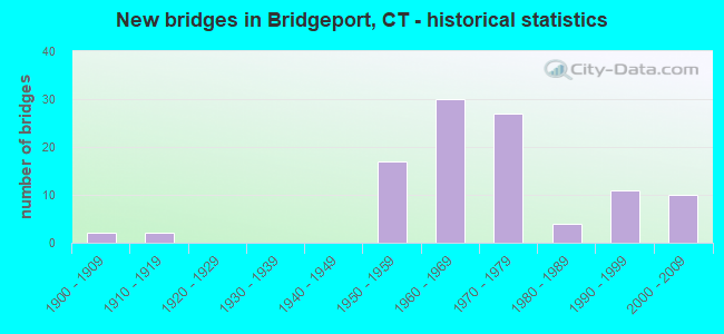
- New bridges - historical statistics
- 21900-1909
- 21910-1919
- 171950-1959
- 301960-1969
- 271970-1979
- 41980-1989
- 111990-1999
- 102000-2009

- Reconstructed bridges - Historical Statistics
- 11920-1929
- 01930-1939
- 01940-1949
- 01950-1959
- 01960-1969
- 01970-1979
- 71980-1989
- 91990-1999
- 52000-2009
- 62010-2019


- Bridge Condition - Deck
- 1.6%Very good
- 58.7%Good
- 39.7%Satisfactory

- Bridge Condition - Superstructure
- 3.1%Very good
- 49.2%Good
- 26.2%Satisfactory
- 18.5%Fair
- 1.5%Poor
- 1.5%Serious

- Bridge Condition - Substructure
- 35.4%Good
- 55.4%Satisfactory
- 6.2%Fair
- 1.5%Poor
- 1.5%Serious

- Bridge Condition - Channel
- 15.0%Good
- 65.0%Satisfactory
- 20.0%Fair

- Bridge Condition - Culverts
- 22.2%Good
- 66.7%Satisfactory
- 11.1%Fair
Find on map >> Show street view
Structure Number: 1, Location: INTERSTATE-95 EXIT NO. 25 (Lat: 41.166747, Lng: -73.217361), Route carried "on" structure: Interstate 95, Year Built: 2006, Status: Open, Structure Length: 5.71m (18.73ft), Average Daily Traffic: 110,600 (year 2020), Truck Traffic: 14%, Average Future Daily Traffic: 164,341 (year 2040), Design Load: HS 20, Features Intersected: ROUTE 130 (FAIRFIELD AV)
Minimum Vertical Clearance: 30+ m (98+ ft), Kilometerpoint: 44.482, Lanes on structure: 7, Lanes under structure: 4, Base Highway Network: Yes, Owner: State Highway Agency, Approaching Roadway Width: 46.9m (153.9ft), Skew: 33 degrees, Material/Design: Steel, Design/Construction: Stringer/Multi-beam, Number Of Spans In Main Unit: 1, Length of Maximum Span: 54.9m (180.1ft), Curb-To-Curb Width: 47.0m (154.2ft), Out-to-Out Width: 50.0m (164.0ft)
Condition: Deck: Good, Superstructure: Very good, Substructure: Good, Inventory Rating: 71.7 metric tons, Method Used To Determine Inventory Rating: Load Factor (LF), Structural Evaluation: Better than present minimum criteria, Deck Geometry: Superior to present desirable criteria, Underclear: Equal to present minimum criteria, Approach Roadway Alignment: Equal to present desirable criteria, Designated Inspection Frequency: Every 24 months, Inspection Date: October 2021, Deck Structure Type: Concrete Cast-file-Place, Wearing Surface/Protective System: Wearing Surface: Bituminous, Membrane: Built-up, Deck Protection: Epoxy Coated Reinforcing
Find on map >> Show street view
Structure Number: 102, Location: 1.0 MI S OF ROUTE 8 (Lat: 41.166342, Lng: -73.210475), Route carried "on" structure: Interstate 95, Year Built: 1959, Year Reconstructed: 2006, Status: Open, Structure Length: 2.53m (8.30ft), Average Daily Traffic: 151,100 (year 2017), Truck Traffic: 9%, Average Future Daily Traffic: 224,519 (year 2037), Design Load: HS 20, Features Intersected: HANCOCK AVENUE
Minimum Vertical Clearance: 30+ m (98+ ft), Kilometerpoint: 45.078, Lanes on structure: 7, Lanes under structure: 2, Base Highway Network: Yes, Owner: State Highway Agency, Approaching Roadway Width: 50.0m (164.0ft), Skew: 30 degrees, Material/Design: Prestressed concrete, Design/Construction: Stringer/Multi-beam, Number Of Spans In Main Unit: 1, Length of Maximum Span: 23.8m (78.1ft), Curb-To-Curb Width: 50.0m (164.0ft), Out-to-Out Width: 53.0m (173.9ft)
Condition: Deck: Good, Superstructure: Good, Substructure: Satisfactory, Operating Rating: 61.6 metric tons, Method Used To Determine Operating Rating: Load and Resistance Factor Rating (LRFR) rating reported by rating factor(RF) method using HL-93 loadings, Inventory Rating: 42.4 metric tons, Method Used To Determine Inventory Rating: Load and Resistance Factor Rating (LRFR) rating reported by rating factor(RF) method using HL-93 loadings, Structural Evaluation: Equal to present minimum criteria, Deck Geometry: Superior to present desirable criteria, Underclear: Better than present minimum criteria, Approach Roadway Alignment: Equal to present desirable criteria, Designated Inspection Frequency: Every 24 months, Inspection Date: July 2021, Deck Structure Type: Concrete Cast-file-Place, Wearing Surface/Protective System: Wearing Surface: Bituminous, Membrane: Built-up, Deck Protection: Epoxy Coated Reinforcing
Find on map >> Show street view
Structure Number: 103, Location: 0.8 MI S OF ROUTE 8 (Lat: 41.166536, Lng: -73.208233), Route carried "on" structure: Interstate 95, Year Built: 1959, Year Reconstructed: 2004, Status: Open, Structure Length: 2.27m (7.45ft), Average Daily Traffic: 148,900 (year 2017), Truck Traffic: 9%, Average Future Daily Traffic: 221,251 (year 2037), Design Load: HS 20, Features Intersected: HOWARD AVENUE
Minimum Vertical Clearance: 30+ m (98+ ft), Kilometerpoint: 45.271, Lanes on structure: 10, Lanes under structure: 2, Base Highway Network: Yes, Owner: State Highway Agency, Approaching Roadway Width: 55.5m (182.1ft), Skew: 30 degrees, Material/Design: Steel, Design/Construction: Stringer/Multi-beam, Number Of Spans In Main Unit: 1, Length of Maximum Span: 21.5m (70.5ft), Curb-To-Curb Width: 55.6m (182.4ft), Out-to-Out Width: 58.6m (192.3ft)
Condition: Deck: Good, Superstructure: Good, Substructure: Satisfactory, Operating Rating: 75.5 metric tons, Method Used To Determine Operating Rating: Load and Resistance Factor Rating (LRFR) rating reported by rating factor(RF) method using HL-93 loadings, Inventory Rating: 58.0 metric tons, Method Used To Determine Inventory Rating: Load and Resistance Factor Rating (LRFR) rating reported by rating factor(RF) method using HL-93 loadings, Structural Evaluation: Equal to present minimum criteria, Deck Geometry: Superior to present desirable criteria, Underclear: Equal to present minimum criteria, Approach Roadway Alignment: Equal to present desirable criteria, Designated Inspection Frequency: Every 24 months, Inspection Date: April 2020, Deck Structure Type: Concrete Cast-file-Place, Wearing Surface/Protective System: Wearing Surface: Bituminous, Membrane: Built-up, Deck Protection: Epoxy Coated Reinforcing
Find on map >> Show street view
Structure Number: 104, Location: 0.7 MI S OF ROUTE 8 (Lat: 41.166814, Lng: -73.205097), Route carried "on" structure: Interstate 95, Year Built: 1959, Year Reconstructed: 2006, Status: Open, Structure Length: 3.11m (10.20ft), Average Daily Traffic: 146,500 (year 2017), Truck Traffic: 9%, Average Future Daily Traffic: 217,684 (year 2037), Design Load: HS 20, Features Intersected: WORDIN AVENUE NO. 2
Minimum Vertical Clearance: 30+ m (98+ ft), Kilometerpoint: 45.528, Lanes on structure: 8, Lanes under structure: 5, Base Highway Network: Yes, Owner: State Highway Agency, Approaching Roadway Width: 47.0m (154.2ft), Skew: 33 degrees, Material/Design: Steel, Design/Construction: Stringer/Multi-beam, Number Of Spans In Main Unit: 1, Length of Maximum Span: 29.3m (96.1ft), Curb-To-Curb Width: 47.0m (154.2ft), Out-to-Out Width: 50.0m (164.0ft)
Condition: Deck: Satisfactory, Superstructure: Good, Substructure: Good, Operating Rating: 95.3 metric tons, Method Used To Determine Operating Rating: Load Factor (LF), Inventory Rating: 57.1 metric tons, Method Used To Determine Inventory Rating: Load Factor (LF), Structural Evaluation: Better than present minimum criteria, Deck Geometry: Superior to present desirable criteria, Underclear: Better than present minimum criteria, Approach Roadway Alignment: Equal to present desirable criteria, Designated Inspection Frequency: Every 24 months, Inspection Date: May 2020, Deck Structure Type: Concrete Cast-file-Place, Wearing Surface/Protective System: Wearing Surface: Bituminous, Membrane: Built-up, Deck Protection: Epoxy Coated Reinforcing
Find on map >> Show street view
Structure Number: 105A, Location: BETWEEN EXITS 26 & 27 (Lat: 41.168936, Lng: -73.198256), Route carried "on" structure: Interstate 95, Year Built: 1999, Status: Open, Structure Length: 66.96m (219.69ft), Average Daily Traffic: 150,800 (year 2017), Truck Traffic: 14%, Average Future Daily Traffic: 224,074 (year 2037), Design Load: HL 93, Features Intersected: METRO NORTH & CITY ST'S
Minimum Vertical Clearance: 7.62m (25.00ft), Kilometerpoint: 45.866, Lanes on structure: 10, Lanes under structure: 12, Base Highway Network: Yes, Owner: State Highway Agency, Approaching Roadway Width: 54.9m (180.1ft), Skew: 30 degrees, Material/Design: Steel continuous, Design/Construction: Stringer/Multi-beam, Number Of Spans In Main Unit: 18, Length of Maximum Span: 48.8m (160.1ft), Curb-To-Curb Width: 50.0m (164.0ft), Out-to-Out Width: 52.8m (173.2ft)
Condition: Deck: Good, Superstructure: Satisfactory, Substructure: Fair, Operating Rating: 46.3 metric tons, Method Used To Determine Operating Rating: Load and Resistance Factor Rating (LRFR) rating reported by rating factor(RF) method using HL-93 loadings, Inventory Rating: 35.6 metric tons, Method Used To Determine Inventory Rating: Load and Resistance Factor Rating (LRFR) rating reported by rating factor(RF) method using HL-93 loadings, Structural Evaluation: Somewhat better than minimum adequacy, Deck Geometry: Superior to present desirable criteria, Underclear: High priority of corrective action, Approach Roadway Alignment: Equal to present desirable criteria, Designated Inspection Frequency: Every 24 months, Critical Feature Inspection Frequency: Every 24 months, Inspection Date: Febuary 2021, Critical Feature Inspection Date: Febuary 2021, Deck Structure Type: Concrete Cast-file-Place, Wearing Surface/Protective System: Wearing Surface: Bituminous, Membrane: Built-up, Deck Protection: Epoxy Coated Reinforcing
Find on map >> Show street view
Structure Number: 107, Location: INTERSTATE 95 EXIT 27 (Lat: 41.171547, Lng: -73.191625), Route carried "on" structure: Interstate 95, Year Built: 1959, Year Reconstructed: 1998, Status: Open, Structure Length: 2.32m (7.61ft), Average Daily Traffic: 101,900 (year 2017), Truck Traffic: 9%, Average Future Daily Traffic: 151,413 (year 2037), Design Load: HS 20, Features Intersected: WARREN STREET
Minimum Vertical Clearance: 30+ m (98+ ft), Kilometerpoint: 46.784, Lanes on structure: 6, Lanes under structure: 4, Base Highway Network: Yes, Owner: State Highway Agency, Approaching Roadway Width: 46.3m (151.9ft), Skew: 31 degrees, Material/Design: Steel, Design/Construction: Stringer/Multi-beam, Number Of Spans In Main Unit: 1, Length of Maximum Span: 22.3m (73.2ft), Curb-To-Curb Width: 46.4m (152.2ft), Out-to-Out Width: 48.7m (159.8ft)
Condition: Deck: Good, Superstructure: Good, Substructure: Good, Operating Rating: 97.2 metric tons, Method Used To Determine Operating Rating: Load and Resistance Factor Rating (LRFR) rating reported by rating factor(RF) method using HL-93 loadings, Inventory Rating: 79.4 metric tons, Method Used To Determine Inventory Rating: Load and Resistance Factor Rating (LRFR) rating reported by rating factor(RF) method using HL-93 loadings, Structural Evaluation: Better than present minimum criteria, Deck Geometry: Superior to present desirable criteria, Underclear: Equal to present minimum criteria, Approach Roadway Alignment: Equal to present desirable criteria, Designated Inspection Frequency: Every 24 months, Inspection Date: April 2020, Total Project Cost: $5,500,000 ( Estimate for 2019), Deck Structure Type: Concrete Cast-file-Place, Wearing Surface/Protective System: Wearing Surface: Bituminous, Membrane: Built-up, Deck Protection: Epoxy Coated Reinforcing
Find on map >> Show street view
Structure Number: 110A, Location: 0.2 MI N OF ROUTE 8 (Lat: 41.173433, Lng: -73.189039), Route carried "on" structure: Interstate 95, Year Built: 1959, Year Reconstructed: 2005, Status: Open, Structure Length: 3.41m (11.19ft), Average Daily Traffic: 104,800 (year 2017), Truck Traffic: 9%, Average Future Daily Traffic: 155,722 (year 2037), Design Load: HS 20, Features Intersected: BROAD STREET
Minimum Vertical Clearance: 30+ m (98+ ft), Kilometerpoint: 47.089, Lanes on structure: 9, Lanes under structure: 4, Base Highway Network: Yes, Owner: State Highway Agency, Approaching Roadway Width: 53.3m (174.9ft), Skew: 34 degrees, Material/Design: Steel, Design/Construction: Stringer/Multi-beam, Number Of Spans In Main Unit: 1, Length of Maximum Span: 32.0m (105.0ft), Curb-To-Curb Width: 53.4m (175.2ft), Out-to-Out Width: 56.3m (184.7ft)
Condition: Deck: Good, Superstructure: Good, Substructure: Satisfactory, Operating Rating: 44.1 metric tons, Method Used To Determine Operating Rating: Load and Resistance Factor Rating (LRFR) rating reported by rating factor(RF) method using HL-93 loadings, Inventory Rating: 34.0 metric tons, Method Used To Determine Inventory Rating: Load and Resistance Factor Rating (LRFR) rating reported by rating factor(RF) method using HL-93 loadings, Structural Evaluation: Equal to present minimum criteria, Deck Geometry: Superior to present desirable criteria, Underclear: Superior to present desirable criteria, Approach Roadway Alignment: Equal to present desirable criteria, Designated Inspection Frequency: Every 24 months, Inspection Date: March 2020, Deck Structure Type: Concrete Cast-file-Place, Wearing Surface/Protective System: Wearing Surface: Bituminous, Membrane: Built-up, Deck Protection: Epoxy Coated Reinforcing
Find on map >> Show street view
Structure Number: 110B, Location: 0.2. MI N OF ROUTE 8 (Lat: 41.173103, Lng: -73.188936), Route carried "on" structure: Ramp Interstate 95, Year Built: 1959, Year Reconstructed: 1999, Status: Open, Structure Length: 3.41m (11.19ft), Average Daily Traffic: 22,800 (year 2014), Truck Traffic: 9%, Average Future Daily Traffic: 33,879 (year 2034), Design Load: HS 20, Features Intersected: BROAD STREET
Minimum Vertical Clearance: 30+ m (98+ ft), Kilometerpoint: 0.241, Lanes on structure: 2, Lanes under structure: 4, Owner: State Highway Agency, Approaching Roadway Width: 11.9m (39.0ft), Skew: 3 degrees, Material/Design: Steel, Design/Construction: Stringer/Multi-beam, Number Of Spans In Main Unit: 1, Length of Maximum Span: 32.6m (107.0ft), Curb-To-Curb Width: 11.6m (38.1ft), Out-to-Out Width: 12.7m (41.7ft)
Condition: Deck: Good, Superstructure: Good, Substructure: Good, Operating Rating: 33.7 metric tons, Method Used To Determine Operating Rating: Load and Resistance Factor Rating (LRFR) rating reported by rating factor(RF) method using HL-93 loadings, Inventory Rating: 25.9 metric tons, Method Used To Determine Inventory Rating: Load and Resistance Factor Rating (LRFR) rating reported by rating factor(RF) method using HL-93 loadings, Structural Evaluation: Equal to present minimum criteria, Deck Geometry: Superior to present desirable criteria, Underclear: Equal to present minimum criteria, Approach Roadway Alignment: Better than present minimum criteria, Designated Inspection Frequency: Every 24 months, Inspection Date: March 2020, Deck Structure Type: Concrete Cast-file-Place, Wearing Surface/Protective System: Wearing Surface: Bituminous, Membrane: Built-up, Deck Protection: Epoxy Coated Reinforcing
Find on map >> Show street view
Structure Number: 111A, Location: I-95 EXIT 27 - EXIT 28 (Lat: 41.177033, Lng: -73.185922), Route carried "on" structure: Interstate 95, Year Built: 1959, Year Reconstructed: 2006, Status: Open, Structure Length: 75.93m (249.11ft), Average Daily Traffic: 128,200 (year 2017), Truck Traffic: 14%, Average Future Daily Traffic: 190,492 (year 2037), Design Load: HS 20, Features Intersected: BPORT HARBOR,RT 130,MNRR
Minimum Vertical Clearance: 7.62m (25.00ft), Kilometerpoint: 47.202, Lanes on structure: 8, Lanes under structure: 10, Base Highway Network: Yes, Owner: State Highway Agency, Approaching Roadway Width: 48.5m (159.1ft), Skew: 39 degrees, Navigation Control: Yes ( Vertical Clearance: 19.8m (65.0ft), Horizontal Clearance: 45.7m (149.9ft)), Material/Design: Steel continuous, Design/Construction: Stringer/Multi-beam, Number Of Spans In Main Unit: 21, Length of Maximum Span: 78.3m (256.9ft), Curb-To-Curb Width: 48.5m (159.1ft), Out-to-Out Width: 51.4m (168.6ft)
Condition: Deck: Satisfactory, Superstructure: Good, Substructure: Satisfactory, Channel: Fair, Operating Rating: 81.8 metric tons, Method Used To Determine Operating Rating: Load Factor (LF), Inventory Rating: 49.0 metric tons, Method Used To Determine Inventory Rating: Load Factor (LF), Structural Evaluation: Equal to present minimum criteria, Deck Geometry: Superior to present desirable criteria, Underclear: High priority of corrective action, Waterway Adequacy: Equal to present desirable criteria, Approach Roadway Alignment: Equal to present minimum criteria, Designated Inspection Frequency: Every 24 months, Inspection Date: July 2020, Deck Structure Type: Concrete Cast-file-Place, Wearing Surface/Protective System: Wearing Surface: Bituminous, Membrane: Built-up, Deck Protection: Epoxy Coated Reinforcing
Find on map >> Show street view
Structure Number: 111B, Location: I-95NB EXIT 28 (Off Ramp) (Lat: 41.178492, Lng: -73.182753), Route carried "on" structure: Ramp Interstate 95, Year Built: 2000, Status: Open, Structure Length: 11.58m (37.99ft), Average Daily Traffic: 5,500 (year 2017), Truck Traffic: 14%, Average Future Daily Traffic: 8,172 (year 2037), Design Load: HS 20, Features Intersected: Route 130 & Kossuth St
Minimum Vertical Clearance: 30+ m (98+ ft), Kilometerpoint: 0.161, Lanes on structure: 1, Lanes under structure: 6, Owner: State Highway Agency, Approaching Roadway Width: 9.1m (29.9ft), Skew: 9 degrees, Material/Design: Steel continuous, Design/Construction: Stringer/Multi-beam, Number Of Spans In Main Unit: 3, Length of Maximum Span: 53.6m (175.9ft), Curb-To-Curb Width: 9.1m (29.9ft), Out-to-Out Width: 10.1m (33.1ft)
Condition: Deck: Good, Superstructure: Good, Substructure: Satisfactory, Operating Rating: 43.1 metric tons, Method Used To Determine Operating Rating: Load and Resistance Factor Rating (LRFR) rating reported by rating factor(RF) method using HL-93 loadings, Inventory Rating: 33.4 metric tons, Method Used To Determine Inventory Rating: Load and Resistance Factor Rating (LRFR) rating reported by rating factor(RF) method using HL-93 loadings, Structural Evaluation: Equal to present minimum criteria, Deck Geometry: Superior to present desirable criteria, Underclear: Equal to present minimum criteria, Approach Roadway Alignment: Equal to present minimum criteria, Designated Inspection Frequency: Every 24 months, Inspection Date: July 2020, Deck Structure Type: Concrete Cast-file-Place, Wearing Surface/Protective System: Wearing Surface: Bituminous, Membrane: Built-up, Deck Protection: Epoxy Coated Reinforcing
Find on map >> Show street view
Structure Number: 111C, Location: I-95 SB ON-RAMP EXIT 28 (Lat: 41.179339, Lng: -73.182664), Route carried "on" structure: Ramp Interstate 95, Year Built: 2006, Status: Open, Structure Length: 14.30m (46.92ft), Average Daily Traffic: 4,800 (year 2017), Truck Traffic: 14%, Average Future Daily Traffic: 7,132 (year 2037), Design Load: HS 20, Features Intersected: KOSSUTH STREET
Minimum Vertical Clearance: 30+ m (98+ ft), Kilometerpoint: 0.145, Lanes on structure: 1, Lanes under structure: 2, Owner: State Highway Agency, Approaching Roadway Width: 8.5m (27.9ft), Skew: 1 degrees, Material/Design: Steel continuous, Design/Construction: Stringer/Multi-beam, Number Of Spans In Main Unit: 6, Length of Maximum Span: 24.4m (80.1ft), Curb-To-Curb Width: 8.6m (28.2ft), Out-to-Out Width: 9.6m (31.5ft)
Condition: Deck: Good, Superstructure: Good, Substructure: Satisfactory, Operating Rating: 33.0 metric tons, Method Used To Determine Operating Rating: Load and Resistance Factor Rating (LRFR) rating reported by rating factor(RF) method using HL-93 loadings, Inventory Rating: 25.6 metric tons, Method Used To Determine Inventory Rating: Load and Resistance Factor Rating (LRFR) rating reported by rating factor(RF) method using HL-93 loadings, Structural Evaluation: Equal to present minimum criteria, Deck Geometry: Superior to present desirable criteria, Underclear: Superior to present desirable criteria, Approach Roadway Alignment: Equal to present minimum criteria, Designated Inspection Frequency: Every 24 months, Inspection Date: July 2020, Deck Structure Type: Concrete Cast-file-Place, Wearing Surface/Protective System: Wearing Surface: Bituminous, Membrane: Preformed Fabric, Deck Protection: Epoxy Coated Reinforcing
Find on map >> Show street view
Structure Number: 115A, Location: INTERSTATE 95 EXIT 29 (Lat: 41.177942, Lng: -73.175111), Route carried "on" structure: Interstate 95, Year Built: 1958, Year Reconstructed: 1999, Status: Open, Structure Length: 39.69m (130.22ft), Average Daily Traffic: 176,600 (year 2017), Truck Traffic: 9%, Average Future Daily Traffic: 262,410 (year 2037), Design Load: HS 20, Features Intersected: YELLOW MILL POND&RTE 130
Minimum Vertical Clearance: 30+ m (98+ ft), Kilometerpoint: 48.393, Lanes on structure: 6, Lanes under structure: 13, Base Highway Network: Yes, Owner: State Highway Agency, Approaching Roadway Width: 40.2m (131.9ft), Skew: 39 degrees, Navigation Control: Yes ( Vertical Clearance: 12.2m (40.0ft), Horizontal Clearance: 32.3m (106.0ft)), Material/Design: Steel continuous, Design/Construction: Stringer/Multi-beam, Number Of Spans In Main Unit: 9, Length of Maximum Span: 84.1m (275.9ft), Curb-To-Curb Width: 40.2m (131.9ft), Out-to-Out Width: 43.1m (141.4ft)
Condition: Deck: Satisfactory, Superstructure: Fair, Substructure: Fair, Channel: Satisfactory, Operating Rating: 73.5 metric tons, Method Used To Determine Operating Rating: Load Factor (LF), Inventory Rating: 44.4 metric tons, Method Used To Determine Inventory Rating: Allowable Stress (AS), Structural Evaluation: Somewhat better than minimum adequacy, Deck Geometry: Superior to present desirable criteria, Underclear: Equal to present minimum criteria, Waterway Adequacy: Superior to present desirable criteria, Approach Roadway Alignment: Equal to present desirable criteria, Designated Inspection Frequency: Every 24 months, Underwater Inspection Frequency: Every 24 months, Inspection Date: August 2021, Underwater Inspection Date: August 2021, Deck Structure Type: Concrete Cast-file-Place, Wearing Surface/Protective System: Wearing Surface: Bituminous, Membrane: Built-up, Deck Protection: Epoxy Coated Reinforcing
Find on map >> Show street view
Structure Number: 115B, Location: I-95 NB EXIT 29 OFF RAMP (Lat: 41.177231, Lng: -73.174461), Route carried "on" structure: Ramp Interstate 95, Year Built: 1999, Status: Open, Structure Length: 10.45m (34.28ft), Average Daily Traffic: 7,200 (year 2017), Truck Traffic: 9%, Average Future Daily Traffic: 10,698 (year 2037), Design Load: HS 20, Features Intersected: RT 130&YELLOW MILL POND
Minimum Vertical Clearance: 30+ m (98+ ft), Kilometerpoint: 48.618, Lanes on structure: 1, Lanes under structure: 6, Owner: State Highway Agency, Approaching Roadway Width: 9.1m (29.9ft), Material/Design: Steel continuous, Design/Construction: Stringer/Multi-beam, Number Of Spans In Main Unit: 3, Length of Maximum Span: 36.3m (119.1ft), Curb-To-Curb Width: 9.1m (29.9ft), Out-to-Out Width: 10.2m (33.5ft)
Condition: Deck: Good, Superstructure: Good, Substructure: Satisfactory, Channel: Good, Operating Rating: 37.6 metric tons, Method Used To Determine Operating Rating: Load and Resistance Factor Rating (LRFR) rating reported by rating factor(RF) method using HL-93 loadings, Inventory Rating: 28.8 metric tons, Method Used To Determine Inventory Rating: Load and Resistance Factor Rating (LRFR) rating reported by rating factor(RF) method using HL-93 loadings, Structural Evaluation: Equal to present minimum criteria, Deck Geometry: Superior to present desirable criteria, Underclear: Better than present minimum criteria, Waterway Adequacy: Equal to present desirable criteria, Approach Roadway Alignment: Equal to present minimum criteria, Designated Inspection Frequency: Every 24 months, Inspection Date: August 2021, Deck Structure Type: Concrete Cast-file-Place, Wearing Surface/Protective System: Wearing Surface: Bituminous, Membrane: Built-up, Deck Protection: Epoxy Coated Reinforcing
Find on map >> Show street view
Structure Number: 115C, Location: RAMP FROM RT 130 TO I95SB (Lat: 41.177950, Lng: -73.173903), Route carried "on" structure: Ramp Interstate 95, Year Built: 1999, Status: Open, Structure Length: 12.04m (39.50ft), Average Daily Traffic: 8,400 (year 2017), Truck Traffic: 9%, Average Future Daily Traffic: 12,482 (year 2037), Design Load: HS 20, Features Intersected: SEAVIEW AVE
Minimum Vertical Clearance: 30+ m (98+ ft), Kilometerpoint: 0.000, Lanes on structure: 1, Lanes under structure: 5, Owner: State Highway Agency, Approaching Roadway Width: 9.1m (29.9ft), Material/Design: Steel continuous, Design/Construction: Stringer/Multi-beam, Number Of Spans In Main Unit: 3, Length of Maximum Span: 49.7m (163.1ft), Curb-To-Curb Width: 9.1m (29.9ft), Out-to-Out Width: 10.2m (33.5ft)
Condition: Deck: Good, Superstructure: Fair, Substructure: Satisfactory, Operating Rating: 57.5 metric tons, Method Used To Determine Operating Rating: Load Factor (LF), Inventory Rating: 34.6 metric tons, Method Used To Determine Inventory Rating: Load Factor (LF), Structural Evaluation: Somewhat better than minimum adequacy, Deck Geometry: Superior to present desirable criteria, Underclear: Superior to present desirable criteria, Approach Roadway Alignment: Equal to present minimum criteria, Designated Inspection Frequency: Every 24 months, Inspection Date: August 2021, Deck Structure Type: Concrete Cast-file-Place, Wearing Surface/Protective System: Wearing Surface: Bituminous, Membrane: Built-up, Deck Protection: Epoxy Coated Reinforcing
Find on map >> Show street view
Structure Number: 119, Location: 0.4 MI S OF ROUTE 113 (Lat: 41.175414, Lng: -73.167317), Route carried "on" structure: Interstate 95, Year Built: 1959, Year Reconstructed: 1995, Status: Open, Structure Length: 2.35m (7.71ft), Average Daily Traffic: 135,400 (year 2017), Truck Traffic: 9%, Average Future Daily Traffic: 201,191 (year 2037), Design Load: HS 20, Features Intersected: NEWFIELD AVENUE
Minimum Vertical Clearance: 30+ m (98+ ft), Kilometerpoint: 49.310, Lanes on structure: 7, Lanes under structure: 2, Base Highway Network: Yes, Owner: State Highway Agency, Approaching Roadway Width: 39.0m (128.0ft), Skew: 31 degrees, Material/Design: Steel, Design/Construction: Stringer/Multi-beam, Number Of Spans In Main Unit: 1, Length of Maximum Span: 22.2m (72.8ft), Curb-To-Curb Width: 39.0m (128.0ft), Out-to-Out Width: 42.0m (137.8ft)
Condition: Deck: Good, Superstructure: Satisfactory, Substructure: Satisfactory, Operating Rating: 92.6 metric tons, Method Used To Determine Operating Rating: Load Factor (LF), Inventory Rating: 55.6 metric tons, Method Used To Determine Inventory Rating: Load Factor (LF), Structural Evaluation: Equal to present minimum criteria, Deck Geometry: Superior to present desirable criteria, Underclear: Meets minimum limits, Approach Roadway Alignment: Equal to present desirable criteria, Designated Inspection Frequency: Every 24 months, Inspection Date: May 2021, Deck Structure Type: Concrete Cast-file-Place, Wearing Surface/Protective System: Wearing Surface: Bituminous, Membrane: Built-up, Deck Protection: Epoxy Coated Reinforcing
Find on map >> Show street view
Structure Number: 12, Location: 0.4 MI N OF ROUTE 130 (Lat: 41.175108, Lng: -73.165331), Route carried "on" structure: Interstate 95, Year Built: 1959, Year Reconstructed: 1995, Status: Open, Structure Length: 2.19m (7.19ft), Average Daily Traffic: 135,400 (year 2017), Truck Traffic: 9%, Average Future Daily Traffic: 201,191 (year 2037), Design Load: HS 20, Features Intersected: CENTRAL AVENUE
Minimum Vertical Clearance: 30+ m (98+ ft), Kilometerpoint: 49.487, Lanes on structure: 6, Lanes under structure: 2, Base Highway Network: Yes, Owner: State Highway Agency, Approaching Roadway Width: 29.3m (96.1ft), Skew: 30 degrees, Material/Design: Steel, Design/Construction: Stringer/Multi-beam, Number Of Spans In Main Unit: 1, Length of Maximum Span: 20.7m (67.9ft), Curb-To-Curb Width: 35.9m (117.8ft), Out-to-Out Width: 38.9m (127.6ft)
Condition: Deck: Good, Superstructure: Satisfactory, Substructure: Satisfactory, Operating Rating: 83.5 metric tons, Method Used To Determine Operating Rating: Load Factor (LF), Inventory Rating: 50.1 metric tons, Method Used To Determine Inventory Rating: Load Factor (LF), Structural Evaluation: Equal to present minimum criteria, Deck Geometry: Superior to present desirable criteria, Underclear: Somewhat better than minimum adequacy, Approach Roadway Alignment: Equal to present desirable criteria, Designated Inspection Frequency: Every 24 months, Inspection Date: April 2020, Deck Structure Type: Concrete Cast-file-Place, Wearing Surface/Protective System: Wearing Surface: Bituminous, Membrane: Preformed Fabric, Deck Protection: Epoxy Coated Reinforcing
Find on map >> Show street view
Structure Number: 121, Location: 0.4 MI N OF ROUTE 130 (Lat: 41.174989, Lng: -73.163639), Route carried "on" structure: Interstate 95, Year Built: 1959, Year Reconstructed: 1989, Status: Open, Structure Length: 2.40m (7.87ft), Average Daily Traffic: 135,400 (year 2017), Truck Traffic: 14%, Average Future Daily Traffic: 201,191 (year 2037), Design Load: H 20, Features Intersected: UNION AVENUE
Minimum Vertical Clearance: 30+ m (98+ ft), Kilometerpoint: 49.632, Lanes on structure: 7, Lanes under structure: 2, Base Highway Network: Yes, Owner: State Highway Agency, Approaching Roadway Width: 36.6m (120.1ft), Skew: 31 degrees, Material/Design: Steel, Design/Construction: Stringer/Multi-beam, Number Of Spans In Main Unit: 1, Length of Maximum Span: 22.7m (74.5ft), Curb-To-Curb Width: 39.0m (128.0ft), Out-to-Out Width: 42.0m (137.8ft)
Condition: Deck: Good, Superstructure: Good, Substructure: Satisfactory, Operating Rating: 87.0 metric tons, Method Used To Determine Operating Rating: Load Factor (LF), Inventory Rating: 52.2 metric tons, Method Used To Determine Inventory Rating: Load Factor (LF), Structural Evaluation: Equal to present minimum criteria, Deck Geometry: Superior to present desirable criteria, Underclear: Meets minimum limits, Approach Roadway Alignment: Equal to present desirable criteria, Designated Inspection Frequency: Every 24 months, Inspection Date: April 2020, Deck Structure Type: Concrete Cast-file-Place, Wearing Surface/Protective System: Wearing Surface: Bituminous, Membrane: Preformed Fabric, Deck Protection: Epoxy Coated Reinforcing
Find on map >> Show street view
Structure Number: 122, Location: 0.7 MI N OF ROUTE 130 (Lat: 41.174761, Lng: -73.159058), Route carried "on" structure: Interstate 95, Year Built: 1959, Year Reconstructed: 1988, Status: Open, Structure Length: 2.76m (9.06ft), Average Daily Traffic: 93,800 (year 2020), Truck Traffic: 9%, Average Future Daily Traffic: 139,377 (year 2040), Design Load: H 20, Features Intersected: RTE 113 (HOLLISTER AVE.)
Minimum Vertical Clearance: 30+ m (98+ ft), Kilometerpoint: 50.002, Lanes on structure: 6, Lanes under structure: 3, Base Highway Network: Yes, Owner: State Highway Agency, Approaching Roadway Width: 36.0m (118.1ft), Skew: 32 degrees, Material/Design: Steel, Design/Construction: Stringer/Multi-beam, Number Of Spans In Main Unit: 1, Length of Maximum Span: 26.0m (85.3ft), Curb-To-Curb Width: 35.9m (117.8ft), Out-to-Out Width: 38.9m (127.6ft)
Condition: Deck: Satisfactory, Superstructure: Satisfactory, Substructure: Satisfactory, Operating Rating: 94.8 metric tons, Method Used To Determine Operating Rating: Load Factor (LF), Inventory Rating: 56.9 metric tons, Method Used To Determine Inventory Rating: Load Factor (LF), Structural Evaluation: Equal to present minimum criteria, Deck Geometry: Superior to present desirable criteria, Underclear: Equal to present minimum criteria, Approach Roadway Alignment: Equal to present desirable criteria, Designated Inspection Frequency: Every 24 months, Inspection Date: November 2021, Deck Structure Type: Concrete Cast-file-Place, Wearing Surface/Protective System: Wearing Surface: Bituminous, Membrane: Preformed Fabric, Deck Protection: Epoxy Coated Reinforcing
Find on map >> Show street view
Structure Number: 325, Location: 0.6 MI N OF ROUTE 127 (Lat: 41.193383, Lng: -73.171511), Route carried "on" structure: US 1, Year Built: 1910, Year Reconstructed: 1934, Status: Open, Structure Length: 2.29m (7.51ft), Average Daily Traffic: 27,000 (year 2013), Truck Traffic: 11%, Average Future Daily Traffic: 40,119 (year 2033), Design Load: H 20, Features Intersected: YELLOW MILL CHANNEL
Minimum Vertical Clearance: 30+ m (98+ ft), Kilometerpoint: 51.467, Lanes on structure: 3, Base Highway Network: Yes, Owner: State Highway Agency, Approaching Roadway Width: 15.9m (52.2ft), Skew: 22 degrees, Material/Design: Concrete, Design/Construction: Arch - Deck, Number Of Spans In Main Unit: 1, Length of Maximum Span: 22.9m (75.1ft), Curb or Sidewalk Widths: Left: 3.0m (9.8ft), Right: 1.8m (5.9ft), Curb-To-Curb Width: 12.2m (40.0ft), Out-to-Out Width: 17.1m (56.1ft)
Condition: Superstructure: Serious, Substructure: Serious, Channel: Satisfactory, Operating Rating: 52.6 metric tons, Method Used To Determine Operating Rating: Field evaluation and documented engineering judgment, Inventory Rating: 30.8 metric tons, Method Used To Determine Inventory Rating: Field evaluation and documented engineering judgment, Structural Evaluation: High priority of corrective action, Deck Geometry: Meets minimum limits, Waterway Adequacy: Equal to present desirable criteria, Approach Roadway Alignment: Equal to present minimum criteria, Designated Inspection Frequency: Every 24 months, Inspection Date: September 2020, Total Project Cost: $9,300,000 ( Estimate for 2015)
Find on map >> Show street view
Structure Number: 1668, Location: 1.4 MI WEST OF I-95 (Lat: 41.153725, Lng: -73.237100), Route carried "on" structure: State highway 130, Year Built: 1910, Status: Open, Structure Length: 1.22m (4.00ft), Average Daily Traffic: 12,900 (year 2019), Truck Traffic: 4%, Average Future Daily Traffic: 19,168 (year 2039), Features Intersected: ASH CREEK
Minimum Vertical Clearance: 30+ m (98+ ft), Kilometerpoint: 0.789, Lanes on structure: 4, Owner: State Highway Agency, Approaching Roadway Width: 17.7m (58.1ft), Material/Design: Concrete, Design/Construction: Arch - Deck, Number Of Spans In Main Unit: 1, Length of Maximum Span: 12.2m (40.0ft), Curb or Sidewalk Widths: Left: 1.7m (5.6ft), Right: 1.7m (5.6ft), Curb-To-Curb Width: 14.9m (48.9ft), Out-to-Out Width: 18.9m (62.0ft)
Condition: Superstructure: Fair, Substructure: Fair, Channel: Fair, Operating Rating: 97.2 metric tons, Method Used To Determine Operating Rating: Load and Resistance Factor Rating (LRFR) rating reported by rating factor(RF) method using HL-93 loadings, Inventory Rating: 97.2 metric tons, Method Used To Determine Inventory Rating: Load and Resistance Factor Rating (LRFR) rating reported by rating factor(RF) method using HL-93 loadings, Structural Evaluation: Somewhat better than minimum adequacy, Deck Geometry: High priority of replacement, Waterway Adequacy: Equal to present minimum criteria, Approach Roadway Alignment: Equal to present desirable criteria, Designated Inspection Frequency: Every 24 months, Inspection Date: November 2021
Find on map >> Show street view
Structure Number: 168, Location: 1.7 MI SOUTH OF ROUTE 8 (Lat: 41.168286, Lng: -73.223119), Route carried "on" structure: Interstate 95, Year Built: 2003, Status: Open, Structure Length: 1.62m (5.31ft), Average Daily Traffic: 115,900 (year 2020), Truck Traffic: 9%, Average Future Daily Traffic: 172,216 (year 2040), Design Load: HS 20, Features Intersected: ASH CREEK
Minimum Vertical Clearance: 30+ m (98+ ft), Kilometerpoint: 43.983, Lanes on structure: 7, Base Highway Network: Yes, Owner: State Highway Agency, Approaching Roadway Width: 55.5m (182.1ft), Skew: 32 degrees, Material/Design: Aluminum, Iron, Design/Construction: Culvert, Number Of Spans In Main Unit: 3, Length of Maximum Span: 4.1m (13.5ft)
Condition: Channel: Satisfactory, Culverts: Good, Structural Evaluation: Better than present minimum criteria, Waterway Adequacy: Equal to present desirable criteria, Approach Roadway Alignment: Equal to present desirable criteria, Designated Inspection Frequency: Every 24 months, Inspection Date: November 2021
Find on map >> Show street view
Structure Number: 1693, Location: 0.5 MI W OF ROUTE 59 (Lat: 41.176411, Lng: -73.222981), Route carried "on" structure: US 1, Year Built: 1963, Status: Open, Structure Length: 1.55m (5.09ft), Average Daily Traffic: 13,400 (year 2019), Truck Traffic: 6%, Average Future Daily Traffic: 19,911 (year 2039), Design Load: HS 20, Features Intersected: ROOSTER RIVER
Minimum Vertical Clearance: 30+ m (98+ ft), Kilometerpoint: 45.384, Lanes on structure: 4, Base Highway Network: Yes, Owner: State Highway Agency, Approaching Roadway Width: 18.3m (60.0ft), Skew: 2 degrees, Material/Design: Steel, Design/Construction: Stringer/Multi-beam, Number Of Spans In Main Unit: 1, Length of Maximum Span: 14.0m (45.9ft), Curb or Sidewalk Widths: Left: 1.4m (4.6ft), Right: 1.4m (4.6ft), Curb-To-Curb Width: 18.3m (60.0ft), Out-to-Out Width: 21.8m (71.5ft)
Condition: Deck: Satisfactory, Superstructure: Fair, Substructure: Good, Channel: Satisfactory, Operating Rating: 41.5 metric tons, Method Used To Determine Operating Rating: Load and Resistance Factor Rating (LRFR) rating reported by rating factor(RF) method using HL-93 loadings, Inventory Rating: 32.1 metric tons, Method Used To Determine Inventory Rating: Load and Resistance Factor Rating (LRFR) rating reported by rating factor(RF) method using HL-93 loadings, Structural Evaluation: Somewhat better than minimum adequacy, Deck Geometry: Somewhat better than minimum adequacy, Waterway Adequacy: Equal to present minimum criteria, Approach Roadway Alignment: Equal to present desirable criteria, Designated Inspection Frequency: Every 24 months, Inspection Date: November 2021, Deck Structure Type: Concrete Cast-file-Place, Wearing Surface/Protective System: Wearing Surface: Bituminous, Membrane: Preformed Fabric
Find on map >> Show street view
Structure Number: 2475, Location: 0.2 MI W OF I-95 (Lat: 41.179308, Lng: -73.185819), Route carried "on" structure: State highway 130, Year Built: 1975, Year Reconstructed: 2007, Status: Posted for load, Structure Length: 16.00m (52.49ft), Average Daily Traffic: 14,600 (year 2019), Truck Traffic: 5%, Average Future Daily Traffic: 21,694 (year 2039), Design Load: HS 20, Features Intersected: PEQUONNOCK RIVER
Minimum Vertical Clearance: 5.05m (16.57ft), Kilometerpoint: 6.244, Lanes on structure: 4, Owner: State Highway Agency, Approaching Roadway Width: 16.8m (55.1ft), Skew: 20 degrees, Navigation Control: Yes ( Vertical Clearance: 20.7m (67.9ft), Horizontal Clearance: 31.7m (104.0ft)), Material/Design: Steel, Design/Construction: Movable - Lift, Number Of Spans In Main Unit: 1, Number Of Approach Spans: 9, Length of Maximum Span: 39.6m (129.9ft), Curb or Sidewalk Widths: Left: 2.2m (7.2ft), Right: 2.2m (7.2ft), Curb-To-Curb Width: 16.2m (53.1ft), Out-to-Out Width: 24.1m (79.1ft)
Condition: Deck: Satisfactory, Superstructure: Poor, Substructure: Poor, Channel: Fair, Operating Rating: 36.0 metric tons, Method Used To Determine Operating Rating: Load and Resistance Factor Rating (LRFR) rating reported by rating factor(RF) method using HL-93 loadings, Inventory Rating: 27.5 metric tons, Method Used To Determine Inventory Rating: Load and Resistance Factor Rating (LRFR) rating reported by rating factor(RF) method using HL-93 loadings, Structural Evaluation: Meets minimum limits, Deck Geometry: Meets minimum limits, Waterway Adequacy: Equal to present desirable criteria, Approach Roadway Alignment: Equal to present desirable criteria, Designated Inspection Frequency: Every 24 months, Inspection Date: October 2020, Total Project Cost: $10,000,000 ( Estimate for 2014), Deck Structure Type: Open Grating, Wearing Surface/Protective System: Wearing Surface: Bituminous
Find on map >> Show street view
Structure Number: 2633, Location: I-95 NORTHOUND EXIT 30 (Lat: 41.174128, Lng: -73.158972), Route carried "on" structure: Ramp Interstate 95, Year Built: 1959, Status: Open, Structure Length: 0.70m (2.30ft), Average Daily Traffic: 27,900 (year 2019), Truck Traffic: 9%, Average Future Daily Traffic: 41,457 (year 2039), Design Load: H 20, Features Intersected: JOHNSONS CREEK
Minimum Vertical Clearance: 30+ m (98+ ft), Kilometerpoint: 0.241, Lanes on structure: 1, Owner: State Highway Agency, Approaching Roadway Width: 6.7m (22.0ft), Skew: 3 degrees, Material/Design: Concrete continuous, Design/Construction: Culvert, Number Of Spans In Main Unit: 2, Length of Maximum Span: 3.4m (11.2ft)
Condition: Channel: Satisfactory, Culverts: Fair, Operating Rating: 91.4 metric tons, Method Used To Determine Operating Rating: Load and Resistance Factor Rating (LRFR) rating reported by rating factor(RF) method using HL-93 loadings, Inventory Rating: 70.3 metric tons, Method Used To Determine Inventory Rating: Load and Resistance Factor Rating (LRFR) rating reported by rating factor(RF) method using HL-93 loadings, Structural Evaluation: Somewhat better than minimum adequacy, Waterway Adequacy: Equal to present minimum criteria, Approach Roadway Alignment: Equal to present desirable criteria, Designated Inspection Frequency: Every 24 months, Inspection Date: December 2021
Find on map >> Show street view
Structure Number: 3532, Location: EXIT 27A I-95 N B (Lat: 41.171217, Lng: -73.191267), Route carried "on" structure: State highway 8, Year Built: 1968, Year Reconstructed: 2002, Status: Open, Structure Length: 5.00m (16.40ft), Average Daily Traffic: 12,250 (year 2018), Truck Traffic: 5%, Average Future Daily Traffic: 18,202 (year 2038), Design Load: HS 20, Features Intersected: WARREN ST& S FRONTAGE RD
Minimum Vertical Clearance: 30+ m (98+ ft), Kilometerpoint: 0.080, Lanes on structure: 1, Lanes under structure: 6, Base Highway Network: Yes, Owner: State Highway Agency, Approaching Roadway Width: 11.3m (37.1ft), Skew: 9 degrees, Material/Design: Steel continuous, Design/Construction: Stringer/Multi-beam, Number Of Spans In Main Unit: 2, Length of Maximum Span: 25.9m (85.0ft), Curb-To-Curb Width: 11.2m (36.7ft), Out-to-Out Width: 12.2m (40.0ft)
Condition: Deck: Good, Superstructure: Very good, Substructure: Satisfactory, Operating Rating: 39.5 metric tons, Method Used To Determine Operating Rating: Load and Resistance Factor Rating (LRFR) rating reported by rating factor(RF) method using HL-93 loadings, Inventory Rating: 30.5 metric tons, Method Used To Determine Inventory Rating: Load and Resistance Factor Rating (LRFR) rating reported by rating factor(RF) method using HL-93 loadings, Structural Evaluation: Equal to present minimum criteria, Deck Geometry: Meets minimum limits, Underclear: High priority of corrective action, Approach Roadway Alignment: High priority of corrective action, Designated Inspection Frequency: Every 48 months, Inspection Date: October 2020, Total Project Cost: $5,500,000 ( Estimate for 2019), Deck Structure Type: Concrete Cast-file-Place, Wearing Surface/Protective System: Wearing Surface: Bituminous, Membrane: Built-up, Deck Protection: Epoxy Coated Reinforcing
Find on map >> Show street view
Structure Number: 3533, Location: RAMP FROM 8 SB TO I-95 NB (Lat: 41.171703, Lng: -73.190353), Route carried "on" structure: Ramp Interstate 95, Year Built: 2000, Status: Open, Structure Length: 5.94m (19.49ft), Average Daily Traffic: 17,800 (year 2017), Truck Traffic: 9%, Average Future Daily Traffic: 26,449 (year 2037), Design Load: HS 20, Features Intersected: S. FRONTAGE RD & LAF. ST
Minimum Vertical Clearance: 30+ m (98+ ft), Kilometerpoint: 0.097, Lanes on structure: 1, Lanes under structure: 4, Owner: State Highway Agency, Approaching Roadway Width: 8.5m (27.9ft), Material/Design: Steel, Design/Construction: Box Beam or Girders - Single/Spread, Number Of Spans In Main Unit: 1, Length of Maximum Span: 57.3m (188.0ft), Curb-To-Curb Width: 8.5m (27.9ft), Out-to-Out Width: 9.6m (31.5ft)
Condition: Deck: Good, Superstructure: Good, Substructure: Good, Operating Rating: 35.3 metric tons, Method Used To Determine Operating Rating: Load and Resistance Factor Rating (LRFR) rating reported by rating factor(RF) method using HL-93 loadings, Inventory Rating: 27.2 metric tons, Method Used To Determine Inventory Rating: Load and Resistance Factor Rating (LRFR) rating reported by rating factor(RF) method using HL-93 loadings, Structural Evaluation: Equal to present minimum criteria, Deck Geometry: Superior to present desirable criteria, Underclear: Somewhat better than minimum adequacy, Approach Roadway Alignment: Equal to present minimum criteria, Designated Inspection Frequency: Every 24 months, Critical Feature Inspection Frequency: Every 24 months, Inspection Date: Febuary 2021, Critical Feature Inspection Date: Febuary 2021, Deck Structure Type: Concrete Cast-file-Place, Wearing Surface/Protective System: Wearing Surface: Bituminous, Membrane: Built-up, Deck Protection: Epoxy Coated Reinforcing
Find on map >> Show street view
Structure Number: 3534, Location: 0.2 MI OFF EXIT 27A I-95 (Lat: 41.170117, Lng: -73.190922), Route carried "on" structure: State highway 8, Year Built: 1969, Year Reconstructed: 1996, Status: Open, Structure Length: 1.89m (6.20ft), Average Daily Traffic: 24,500 (year 2018), Truck Traffic: 10%, Average Future Daily Traffic: 36,405 (year 2038), Design Load: HS 20, Features Intersected: WARREN STREET
Minimum Vertical Clearance: 30+ m (98+ ft), Kilometerpoint: 0.225, Lanes on structure: 3, Lanes under structure: 2, Base Highway Network: Yes, Owner: State Highway Agency, Approaching Roadway Width: 19.8m (65.0ft), Skew: 31 degrees, Material/Design: Prestressed concrete, Design/Construction: Stringer/Multi-beam, Number Of Spans In Main Unit: 1, Length of Maximum Span: 17.7m (58.1ft), Curb-To-Curb Width: 20.0m (65.6ft), Out-to-Out Width: 22.3m (73.2ft)
Condition: Deck: Good, Superstructure: Satisfactory, Substructure: Good, Operating Rating: 52.5 metric tons, Method Used To Determine Operating Rating: Load and Resistance Factor Rating (LRFR) rating reported by rating factor(RF) method using HL-93 loadings, Inventory Rating: 39.5 metric tons, Method Used To Determine Inventory Rating: Load and Resistance Factor Rating (LRFR) rating reported by rating factor(RF) method using HL-93 loadings, Structural Evaluation: Equal to present minimum criteria, Deck Geometry: Superior to present desirable criteria, Underclear: Somewhat better than minimum adequacy, Approach Roadway Alignment: High priority of corrective action, Designated Inspection Frequency: Every 24 months, Inspection Date: June 2020, Deck Structure Type: Concrete Cast-file-Place, Wearing Surface/Protective System: Wearing Surface: Bituminous, Membrane: Built-up
Find on map >> Show street view
Structure Number: 3535, Location: I-95 EXIT 27A INTCHGNO 14 (Lat: 41.171025, Lng: -73.192511), Route carried "on" structure: State highway 8, Year Built: 1999, Status: Open, Structure Length: 18.62m (61.09ft), Average Daily Traffic: 41,200 (year 2018), Truck Traffic: 8%, Average Future Daily Traffic: 61,219 (year 2038), Design Load: HS 20, Features Intersected: I-95,S FRONTAGE RD,S.AVE
Minimum Vertical Clearance: 30+ m (98+ ft), Kilometerpoint: 0.338, Lanes on structure: 3, Lanes under structure: 15, Base Highway Network: Yes, Owner: State Highway Agency, Approaching Roadway Width: 17.4m (57.1ft), Skew: 31 degrees, Material/Design: Steel continuous, Design/Construction: Stringer/Multi-beam, Number Of Spans In Main Unit: 4, Length of Maximum Span: 57.6m (189.0ft), Curb-To-Curb Width: 17.5m (57.4ft), Out-to-Out Width: 19.7m (64.6ft)
Condition: Deck: Satisfactory, Superstructure: Good, Substructure: Good, Operating Rating: 29.2 metric tons, Method Used To Determine Operating Rating: Load and Resistance Factor Rating (LRFR) rating reported by rating factor(RF) method using HL-93 loadings, Inventory Rating: 22.7 metric tons, Method Used To Determine Inventory Rating: Load and Resistance Factor Rating (LRFR) rating reported by rating factor(RF) method using HL-93 loadings, Structural Evaluation: Somewhat better than minimum adequacy, Deck Geometry: Better than present minimum criteria, Underclear: High priority of corrective action, Approach Roadway Alignment: Equal to present minimum criteria, Designated Inspection Frequency: Every 24 months, Inspection Date: August 2020, Deck Structure Type: Concrete Cast-file-Place, Wearing Surface/Protective System: Wearing Surface: Bituminous, Membrane: Built-up, Deck Protection: Epoxy Coated Reinforcing
Find on map >> Show street view
Structure Number: 3536, Location: I-95 SB EXIT NO. 27A (Lat: 41.171953, Lng: -73.191828), Route carried "on" structure: Ramp Interstate 95, Year Built: 1968, Status: Open, Structure Length: 3.76m (12.34ft), Average Daily Traffic: 17,900 (year 2018), Truck Traffic: 9%, Average Future Daily Traffic: 26,598 (year 2038), Design Load: HS 20, Features Intersected: SOUTH AVE & WARREN ST
Minimum Vertical Clearance: 30+ m (98+ ft), Kilometerpoint: 0.080, Lanes on structure: 1, Lanes under structure: 4, Owner: State Highway Agency, Approaching Roadway Width: 8.2m (26.9ft), Skew: 9 degrees, Material/Design: Steel, Design/Construction: Stringer/Multi-beam, Number Of Spans In Main Unit: 1, Length of Maximum Span: 36.0m (118.1ft), Curb-To-Curb Width: 7.8m (25.6ft), Out-to-Out Width: 9.3m (30.5ft)
Condition: Deck: Satisfactory, Superstructure: Good, Substructure: Good, Operating Rating: 90.2 metric tons, Method Used To Determine Operating Rating: Load Factor (LF), Inventory Rating: 54.2 metric tons, Method Used To Determine Inventory Rating: Load Factor (LF), Structural Evaluation: Better than present minimum criteria, Deck Geometry: Better than present minimum criteria, Underclear: Equal to present minimum criteria, Approach Roadway Alignment: Equal to present minimum criteria, Designated Inspection Frequency: Every 24 months, Inspection Date: December 2020, Deck Structure Type: Concrete Cast-file-Place, Wearing Surface/Protective System: Wearing Surface: Bituminous, Membrane: Preformed Fabric
Find on map >> Show street view
Structure Number: 3537, Location: ROUTE 8 SB EXIT NO. 1 (Lat: 41.171531, Lng: -73.193322), Route carried "on" structure: Ramp Interstate 95, Year Built: 2002, Status: Open, Structure Length: 15.88m (52.10ft), Average Daily Traffic: 24,300 (year 2018), Truck Traffic: 9%, Average Future Daily Traffic: 36,107 (year 2038), Design Load: HS 20, Features Intersected: I-95 RAMP & LOCAL AVE's
Minimum Vertical Clearance: 30+ m (98+ ft), Kilometerpoint: 0.000, Lanes on structure: 1, Lanes under structure: 5, Owner: State Highway Agency, Approaching Roadway Width: 8.5m (27.9ft), Material/Design: Steel continuous, Design/Construction: Stringer/Multi-beam, Number Of Spans In Main Unit: 4, Length of Maximum Span: 43.0m (141.1ft), Curb-To-Curb Width: 8.6m (28.2ft), Out-to-Out Width: 9.7m (31.8ft)
Condition: Deck: Good, Superstructure: Good, Substructure: Fair, Operating Rating: 30.8 metric tons, Method Used To Determine Operating Rating: Load and Resistance Factor Rating (LRFR) rating reported by rating factor(RF) method using HL-93 loadings, Inventory Rating: 23.7 metric tons, Method Used To Determine Inventory Rating: Load and Resistance Factor Rating (LRFR) rating reported by rating factor(RF) method using HL-93 loadings, Structural Evaluation: Somewhat better than minimum adequacy, Deck Geometry: Superior to present desirable criteria, Underclear: Meets minimum limits, Approach Roadway Alignment: Better than present minimum criteria, Designated Inspection Frequency: Every 24 months, Inspection Date: December 2020, Deck Structure Type: Concrete Cast-file-Place, Wearing Surface/Protective System: Wearing Surface: Bituminous, Membrane: Built-up, Deck Protection: Epoxy Coated Reinforcing
Find on map >> Show street view
Structure Number: 3538, Location: 0.4 MI N OF I-95 (Lat: 41.172822, Lng: -73.193214), Route carried "on" structure: State highway 8, Year Built: 1968, Status: Open, Structure Length: 2.04m (6.69ft), Average Daily Traffic: 41,200 (year 2018), Truck Traffic: 8%, Average Future Daily Traffic: 61,219 (year 2038), Design Load: HS 20, Features Intersected: PROSPECT STREET
Minimum Vertical Clearance: 30+ m (98+ ft), Kilometerpoint: 0.644, Lanes on structure: 5, Lanes under structure: 2, Base Highway Network: Yes, Owner: State Highway Agency, Approaching Roadway Width: 32.6m (107.0ft), Skew: 30 degrees, Material/Design: Steel, Design/Construction: Stringer/Multi-beam, Number Of Spans In Main Unit: 1, Length of Maximum Span: 18.9m (62.0ft), Curb-To-Curb Width: 32.7m (107.3ft), Out-to-Out Width: 34.4m (112.9ft)
Condition: Deck: Satisfactory, Superstructure: Good, Substructure: Good, Operating Rating: 51.8 metric tons, Method Used To Determine Operating Rating: Load and Resistance Factor Rating (LRFR) rating reported by rating factor(RF) method using HL-93 loadings, Inventory Rating: 39.9 metric tons, Method Used To Determine Inventory Rating: Load and Resistance Factor Rating (LRFR) rating reported by rating factor(RF) method using HL-93 loadings, Structural Evaluation: Better than present minimum criteria, Deck Geometry: Superior to present desirable criteria, Underclear: Equal to present minimum criteria, Approach Roadway Alignment: Somewhat better than minimum adequacy, Designated Inspection Frequency: Every 24 months, Inspection Date: April 2020, Deck Structure Type: Concrete Cast-file-Place, Wearing Surface/Protective System: Wearing Surface: Bituminous, Membrane: Built-up
Find on map >> Show street view
Structure Number: 3539A, Location: 0.6 MI N OF I-95 (Lat: 41.174892, Lng: -73.194828), Route carried "on" structure: State highway 8, Year Built: 1968, Status: Open, Structure Length: 2.29m (7.51ft), Average Daily Traffic: 46,900 (year 2018), Truck Traffic: 8%, Average Future Daily Traffic: 69,689 (year 2038), Design Load: HS 20, Features Intersected: ROUTE 130 EAST BOUND
Minimum Vertical Clearance: 30+ m (98+ ft), Kilometerpoint: 0.917, Lanes on structure: 3, Lanes under structure: 2, Base Highway Network: Yes, Owner: State Highway Agency, Approaching Roadway Width: 14.6m (47.9ft), Material/Design: Steel, Design/Construction: Stringer/Multi-beam, Number Of Spans In Main Unit: 1, Length of Maximum Span: 22.3m (73.2ft), Curb or Sidewalk Widths: Left: 0.2m (0.7ft), Right: 0.0m, Curb-To-Curb Width: 14.9m (48.9ft), Out-to-Out Width: 16.0m (52.5ft)
Condition: Deck: Satisfactory, Superstructure: Satisfactory, Substructure: Satisfactory, Operating Rating: 94.5 metric tons, Method Used To Determine Operating Rating: Load Factor (LF), Inventory Rating: 56.7 metric tons, Method Used To Determine Inventory Rating: Load Factor (LF), Structural Evaluation: Equal to present minimum criteria, Deck Geometry: Meets minimum limits, Underclear: Somewhat better than minimum adequacy, Approach Roadway Alignment: Equal to present desirable criteria, Designated Inspection Frequency: Every 24 months, Inspection Date: April 2020, Deck Structure Type: Concrete Cast-file-Place, Wearing Surface/Protective System: Wearing Surface: Bituminous, Membrane: Preformed Fabric
Find on map >> Show street view
Structure Number: 3539B, Location: 0.6 MI N OF I-95 (Lat: 41.174797, Lng: -73.195139), Route carried "on" structure: State highway 8, Year Built: 1968, Status: Open, Structure Length: 2.29m (7.51ft), Average Daily Traffic: 46,900 (year 2018), Truck Traffic: 8%, Average Future Daily Traffic: 69,689 (year 2038), Design Load: HS 20, Features Intersected: ROUTE 130 EAST BOUND
Minimum Vertical Clearance: 30+ m (98+ ft), Kilometerpoint: 0.917, Lanes on structure: 3, Lanes under structure: 2, Base Highway Network: Yes, Owner: State Highway Agency, Approaching Roadway Width: 14.6m (47.9ft), Material/Design: Steel, Design/Construction: Stringer/Multi-beam, Number Of Spans In Main Unit: 1, Length of Maximum Span: 22.3m (73.2ft), Curb or Sidewalk Widths: Left: 0.2m (0.7ft), Right: 0.0m, Curb-To-Curb Width: 14.9m (48.9ft), Out-to-Out Width: 16.0m (52.5ft)
Condition: Deck: Good, Superstructure: Satisfactory, Substructure: Satisfactory, Operating Rating: 94.5 metric tons, Method Used To Determine Operating Rating: Load Factor (LF), Inventory Rating: 56.7 metric tons, Method Used To Determine Inventory Rating: Load Factor (LF), Structural Evaluation: Equal to present minimum criteria, Deck Geometry: Meets minimum limits, Underclear: Better than present minimum criteria, Approach Roadway Alignment: Equal to present desirable criteria, Designated Inspection Frequency: Every 24 months, Inspection Date: April 2020, Deck Structure Type: Concrete Cast-file-Place, Wearing Surface/Protective System: Wearing Surface: Bituminous, Membrane: Preformed Fabric
Find on map >> Show street view
Structure Number: 3540A, Location: 0.6 MI N OF I-95 (Lat: 41.175806, Lng: -73.195200), Route carried "on" structure: State highway 8, Year Built: 1968, Status: Open, Structure Length: 2.19m (7.19ft), Average Daily Traffic: 46,550 (year 2015), Truck Traffic: 5%, Average Future Daily Traffic: 69,169 (year 2035), Design Load: HS 20, Features Intersected: JOHN STREET
Minimum Vertical Clearance: 30+ m (98+ ft), Kilometerpoint: 1.030, Lanes on structure: 3, Lanes under structure: 2, Base Highway Network: Yes, Owner: State Highway Agency, Approaching Roadway Width: 14.6m (47.9ft), Skew: 1 degrees, Material/Design: Steel, Design/Construction: Stringer/Multi-beam, Number Of Spans In Main Unit: 1, Length of Maximum Span: 20.1m (65.9ft), Curb or Sidewalk Widths: Left: 0.2m (0.7ft), Right: 0.0m, Curb-To-Curb Width: 14.6m (47.9ft), Out-to-Out Width: 16.0m (52.5ft)
Condition: Deck: Good, Superstructure: Good, Substructure: Good, Operating Rating: 91.4 metric tons, Method Used To Determine Operating Rating: Load Factor (LF), Inventory Rating: 54.9 metric tons, Method Used To Determine Inventory Rating: Load Factor (LF), Structural Evaluation: Better than present minimum criteria, Deck Geometry: Meets minimum limits, Underclear: Somewhat better than minimum adequacy, Approach Roadway Alignment: Equal to present desirable criteria, Designated Inspection Frequency: Every 24 months, Inspection Date: May 2020, Deck Structure Type: Concrete Cast-file-Place, Wearing Surface/Protective System: Wearing Surface: Bituminous, Membrane: Preformed Fabric
Find on map >> Show street view
Structure Number: 3540B, Location: 0.6 MI N OF I-95 (Lat: 41.175697, Lng: -73.195511), Route carried "on" structure: State highway 8, Year Built: 1968, Status: Open, Structure Length: 2.07m (6.79ft), Average Daily Traffic: 46,550 (year 2015), Truck Traffic: 5%, Average Future Daily Traffic: 69,169 (year 2035), Design Load: HS 20, Features Intersected: JOHN STREET
Minimum Vertical Clearance: 30+ m (98+ ft), Kilometerpoint: 1.030, Lanes on structure: 3, Lanes under structure: 2, Base Highway Network: Yes, Owner: State Highway Agency, Approaching Roadway Width: 14.6m (47.9ft), Skew: 1 degrees, Material/Design: Steel, Design/Construction: Stringer/Multi-beam, Number Of Spans In Main Unit: 1, Length of Maximum Span: 19.8m (65.0ft), Curb or Sidewalk Widths: Left: 0.2m (0.7ft), Right: 0.0m, Curb-To-Curb Width: 14.6m (47.9ft), Out-to-Out Width: 16.0m (52.5ft)
Condition: Deck: Good, Superstructure: Good, Substructure: Good, Operating Rating: 90.2 metric tons, Method Used To Determine Operating Rating: Load Factor (LF), Inventory Rating: 54.1 metric tons, Method Used To Determine Inventory Rating: Load Factor (LF), Structural Evaluation: Better than present minimum criteria, Deck Geometry: Meets minimum limits, Underclear: Superior to present desirable criteria, Approach Roadway Alignment: Equal to present desirable criteria, Designated Inspection Frequency: Every 24 months, Inspection Date: May 2020, Deck Structure Type: Concrete Cast-file-Place, Wearing Surface/Protective System: Wearing Surface: Bituminous, Membrane: Preformed Fabric
Find on map >> Show street view
Structure Number: 3541A, Location: 0.7 MI N OF I-95 (Lat: 41.176889, Lng: -73.195275), Route carried "on" structure: State highway 8, Year Built: 1969, Status: Open, Structure Length: 2.80m (9.19ft), Average Daily Traffic: 46,550 (year 2015), Truck Traffic: 8%, Average Future Daily Traffic: 69,169 (year 2035), Design Load: HS 20, Features Intersected: SR 700 FAIRFIELD AVE.
Minimum Vertical Clearance: 30+ m (98+ ft), Kilometerpoint: 1.143, Lanes on structure: 3, Lanes under structure: 2, Base Highway Network: Yes, Owner: State Highway Agency, Approaching Roadway Width: 14.6m (47.9ft), Skew: 14 degrees, Material/Design: Prestressed concrete, Design/Construction: Stringer/Multi-beam, Number Of Spans In Main Unit: 1, Length of Maximum Span: 25.3m (83.0ft), Curb or Sidewalk Widths: Left: 0.2m (0.7ft), Right: 0.0m, Curb-To-Curb Width: 14.9m (48.9ft), Out-to-Out Width: 16.0m (52.5ft)
Condition: Deck: Good, Superstructure: Good, Substructure: Good, Operating Rating: 54.8 metric tons, Method Used To Determine Operating Rating: Load and Resistance Factor Rating (LRFR) rating reported by rating factor(RF) method using HL-93 loadings, Inventory Rating: 41.1 metric tons, Method Used To Determine Inventory Rating: Load and Resistance Factor Rating (LRFR) rating reported by rating factor(RF) method using HL-93 loadings, Structural Evaluation: Better than present minimum criteria, Deck Geometry: Meets minimum limits, Underclear: Equal to present minimum criteria, Approach Roadway Alignment: Better than present minimum criteria, Designated Inspection Frequency: Every 48 months, Inspection Date: March 2018, Deck Structure Type: Concrete Cast-file-Place, Wearing Surface/Protective System: Wearing Surface: Bituminous, Membrane: Preformed Fabric
Find on map >> Show street view
Structure Number: 3541B, Location: 0.7 MI N OF I-95 (Lat: 41.176703, Lng: -73.195631), Route carried "on" structure: State highway 8, Year Built: 1968, Status: Open, Structure Length: 2.59m (8.50ft), Average Daily Traffic: 46,550 (year 2015), Truck Traffic: 8%, Average Future Daily Traffic: 69,169 (year 2035), Design Load: HS 20, Features Intersected: SR 700 FAIRFIELD AV
Minimum Vertical Clearance: 30+ m (98+ ft), Kilometerpoint: 1.143, Lanes on structure: 3, Lanes under structure: 2, Base Highway Network: Yes, Owner: State Highway Agency, Approaching Roadway Width: 14.6m (47.9ft), Skew: 14 degrees, Material/Design: Prestressed concrete, Design/Construction: Stringer/Multi-beam, Number Of Spans In Main Unit: 1, Length of Maximum Span: 23.8m (78.1ft), Curb or Sidewalk Widths: Left: 0.2m (0.7ft), Right: 0.0m, Curb-To-Curb Width: 14.9m (48.9ft), Out-to-Out Width: 16.0m (52.5ft)
Condition: Deck: Good, Superstructure: Good, Substructure: Good, Operating Rating: 53.1 metric tons, Method Used To Determine Operating Rating: Load and Resistance Factor Rating (LRFR) rating reported by rating factor(RF) method using HL-93 loadings, Inventory Rating: 39.9 metric tons, Method Used To Determine Inventory Rating: Load and Resistance Factor Rating (LRFR) rating reported by rating factor(RF) method using HL-93 loadings, Structural Evaluation: Better than present minimum criteria, Deck Geometry: Meets minimum limits, Underclear: Equal to present minimum criteria, Approach Roadway Alignment: Better than present minimum criteria, Designated Inspection Frequency: Every 48 months, Inspection Date: March 2018, Deck Structure Type: Concrete Cast-file-Place, Wearing Surface/Protective System: Wearing Surface: Bituminous, Membrane: Preformed Fabric
Find on map >> Show street view
Structure Number: 3542A, Location: ROUTE 8 NB EXIT NO. 2 (Lat: 41.177978, Lng: -73.194944), Route carried "on" structure: State highway 8, Year Built: 1968, Status: Open, Structure Length: 2.77m (9.09ft), Average Daily Traffic: 39,600 (year 2018), Truck Traffic: 5%, Average Future Daily Traffic: 58,842 (year 2038), Design Load: HS 20, Features Intersected: ROUTE 8 SB RAMP 126
Minimum Vertical Clearance: 30+ m (98+ ft), Kilometerpoint: 1.287, Lanes on structure: 3, Lanes under structure: 1, Base Highway Network: Yes, Owner: State Highway Agency, Approaching Roadway Width: 19.2m (63.0ft), Skew: 15 degrees, Material/Design: Steel, Design/Construction: Stringer/Multi-beam, Number Of Spans In Main Unit: 1, Length of Maximum Span: 25.3m (83.0ft), Curb or Sidewalk Widths: Left: 0.2m (0.7ft), Right: 0.0m, Curb-To-Curb Width: 18.3m (60.0ft), Out-to-Out Width: 23.9m (78.4ft)
Condition: Deck: Satisfactory, Superstructure: Good, Substructure: Satisfactory, Operating Rating: 88.3 metric tons, Method Used To Determine Operating Rating: Load Factor (LF), Inventory Rating: 53.0 metric tons, Method Used To Determine Inventory Rating: Load Factor (LF), Structural Evaluation: Equal to present minimum criteria, Deck Geometry: Better than present minimum criteria, Underclear: Superior to present desirable criteria, Approach Roadway Alignment: Equal to present desirable criteria, Designated Inspection Frequency: Every 24 months, Inspection Date: March 2021, Deck Structure Type: Concrete Cast-file-Place, Wearing Surface/Protective System: Wearing Surface: Bituminous, Membrane: Preformed Fabric
Find on map >> Show street view
Structure Number: 3542B, Location: ROUTE 8 SB EXIT NO 2 (Lat: 41.178411, Lng: -73.195214), Route carried "on" structure: State highway 8, Year Built: 1968, Status: Open, Structure Length: 2.77m (9.09ft), Average Daily Traffic: 39,600 (year 2018), Truck Traffic: 5%, Average Future Daily Traffic: 58,842 (year 2038), Design Load: HS 20, Features Intersected: ROUTE 8 SB RAMP 126
Minimum Vertical Clearance: 30+ m (98+ ft), Kilometerpoint: 1.287, Lanes on structure: 2, Lanes under structure: 1, Base Highway Network: Yes, Owner: State Highway Agency, Approaching Roadway Width: 13.4m (44.0ft), Skew: 15 degrees, Material/Design: Steel, Design/Construction: Stringer/Multi-beam, Number Of Spans In Main Unit: 1, Length of Maximum Span: 25.3m (83.0ft), Curb or Sidewalk Widths: Left: 0.2m (0.7ft), Right: 0.2m (0.7ft), Curb-To-Curb Width: 13.2m (43.3ft), Out-to-Out Width: 14.5m (47.6ft)
Condition: Deck: Satisfactory, Superstructure: Good, Substructure: Satisfactory, Operating Rating: 98.6 metric tons, Method Used To Determine Operating Rating: Load Factor (LF), Inventory Rating: 59.1 metric tons, Method Used To Determine Inventory Rating: Load Factor (LF), Structural Evaluation: Equal to present minimum criteria, Deck Geometry: Superior to present desirable criteria, Underclear: Somewhat better than minimum adequacy, Approach Roadway Alignment: Equal to present desirable criteria, Designated Inspection Frequency: Every 24 months, Inspection Date: March 2021, Deck Structure Type: Concrete Cast-file-Place, Wearing Surface/Protective System: Wearing Surface: Bituminous, Membrane: Preformed Fabric