Bridge Statistics for Byhalia, Mississippi (MS)
Condition, Traffic, Stress, Structural Evaluation, Project Costs
- National Bridge Inventory (NBI) Statistics
- 117Number of bridges
- 2,717ft / 828mTotal length
- $4,681,809,000Total costs
- 782,155Total average daily traffic
- 150,740Total average daily truck traffic
- National Bridge Inventory (NBI) Registered Bridges for Byhalia
- No street view available for this location
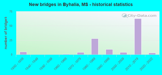
- New bridges - historical statistics
- 51930-1939
- 11960-1969
- 41970-1979
- 281980-1989
- 91990-1999
- 42000-2009
- 632010-2019
- 32020-2022


- Bridge Condition - Deck
- 20.0%Very good
- 48.3%Good
- 20.0%Satisfactory
- 11.7%Fair

- Bridge Condition - Superstructure
- 40.0%Very good
- 33.3%Good
- 10.0%Satisfactory
- 15.0%Fair
- 1.7%Poor

- Bridge Condition - Substructure
- 38.3%Very good
- 41.7%Good
- 11.7%Satisfactory
- 6.7%Fair
- 1.7%Poor

- Bridge Condition - Channel
- 21.4%Excellent
- 7.1%Very good
- 26.2%Good
- 33.3%Satisfactory
- 11.9%Fair

- Bridge Condition - Culverts
- 28.6%Very good
- 14.3%Good
- 57.1%Satisfactory
Find on map >> Show street view
Structure Number: 1100269017015, Location: 0.7 MI N I 55 (Lat: 34.861392, Lng: -89.979642), Route carried "on" structure: Interstate 269, Year Built: 2016, Status: Open, Structure Length: 0.91m (2.99ft), Average Daily Traffic: 21,000 (year 2020), Truck Traffic: 20%, Average Future Daily Traffic: 33,000 (year 2040), Design Load: HS 20+Mod, Features Intersected: STREAM
Minimum Vertical Clearance: 30+ m (98+ ft), Kilometerpoint: 0.927, Lanes on structure: 4, Base Highway Network: Yes (Inventory Route: 26, Subroute: 1), Owner: State Highway Agency, Approaching Roadway Width: 36.6m (120.1ft), Skew: 3 degrees, Material/Design: Concrete, Design/Construction: Culvert, Number Of Spans In Main Unit: 2, Length of Maximum Span: 3.7m (12.1ft)
Condition: Channel: Very good, Culverts: Very good, Structural Evaluation: Equal to present desirable criteria, Waterway Adequacy: Superior to present desirable criteria, Approach Roadway Alignment: Equal to present desirable criteria, Designated Inspection Frequency: Every 24 months, Inspection Date: December 2021
Find on map >> Show street view
Structure Number: 11002690170298A, Location: I 269 OVER I 22 (Lat: 34.879794, Lng: -89.724486), Route carried "on" structure: Interstate 269, Year Built: 2016, Status: Open, Structure Length: 16.53m (54.23ft), Average Daily Traffic: 8,000 (year 2020), Truck Traffic: 25%, Average Future Daily Traffic: 12,500 (year 2040), Design Load: HL 93, Features Intersected: I 22
Minimum Vertical Clearance: 30+ m (98+ ft), Kilometerpoint: 0.074, Lanes on structure: 2, Lanes under structure: 8, Base Highway Network: Yes (Inventory Route: 26, Subroute: 1), Owner: State Highway Agency, Approaching Roadway Width: 14.6m (47.9ft), Material/Design: Prestressed concrete continuous, Design/Construction: Stringer/Multi-beam, Number Of Spans In Main Unit: 6, Length of Maximum Span: 29.0m (95.1ft), Curb-To-Curb Width: 14.6m (47.9ft), Out-to-Out Width: 15.5m (50.9ft)
Condition: Deck: Good, Superstructure: Very good, Substructure: Very good, Operating Rating: 51.2 metric tons, Method Used To Determine Operating Rating: Load and Resistance Factor (LRFR), Inventory Rating: 37.3 metric tons, Method Used To Determine Inventory Rating: Load and Resistance Factor (LRFR), Structural Evaluation: Equal to present desirable criteria, Deck Geometry: Superior to present desirable criteria, Underclear: Equal to present desirable criteria, Approach Roadway Alignment: Equal to present desirable criteria, Designated Inspection Frequency: Every 24 months, Inspection Date: October 2021, Deck Structure Type: Concrete Cast-file-Place
Find on map >> Show street view
Structure Number: 11002690170298B, Location: I 269 OVER I 22 (Lat: 34.878722, Lng: -89.725747), Route carried "on" structure: Interstate 269, Year Built: 2016, Status: Open, Structure Length: 16.53m (54.23ft), Average Daily Traffic: 8,000 (year 2020), Truck Traffic: 26%, Average Future Daily Traffic: 12,500 (year 2040), Design Load: HL 93, Features Intersected: I 22
Minimum Vertical Clearance: 30+ m (98+ ft), Kilometerpoint: 24.922, Lanes on structure: 2, Lanes under structure: 8, Base Highway Network: Yes (Inventory Route: 26, Subroute: 1), Owner: State Highway Agency, Approaching Roadway Width: 14.6m (47.9ft), Material/Design: Prestressed concrete continuous, Design/Construction: Stringer/Multi-beam, Number Of Spans In Main Unit: 6, Length of Maximum Span: 29.0m (95.1ft), Curb-To-Curb Width: 14.6m (47.9ft), Out-to-Out Width: 15.5m (50.9ft)
Condition: Deck: Good, Superstructure: Very good, Substructure: Very good, Operating Rating: 51.2 metric tons, Method Used To Determine Operating Rating: Load and Resistance Factor (LRFR), Inventory Rating: 37.3 metric tons, Method Used To Determine Inventory Rating: Load and Resistance Factor (LRFR), Structural Evaluation: Equal to present desirable criteria, Deck Geometry: Superior to present desirable criteria, Underclear: Equal to present desirable criteria, Approach Roadway Alignment: Equal to present desirable criteria, Designated Inspection Frequency: Every 24 months, Inspection Date: October 2021, Deck Structure Type: Concrete Cast-file-Place
Find on map >> Show street view
Structure Number: 11002690470302A, Location: I 269 OVER SR 178 (Lat: 34.884567, Lng: -89.716322), Route carried "on" structure: Interstate 269, Year Built: 2016, Status: Open, Structure Length: 47.44m (155.64ft), Average Daily Traffic: 6,000 (year 2020), Truck Traffic: 17%, Average Future Daily Traffic: 8,000 (year 2040), Design Load: HL 93, Features Intersected: SR 178/BNSF RR/MASON RD
Minimum Vertical Clearance: 30+ m (98+ ft), Kilometerpoint: 15.871, Lanes on structure: 2, Lanes under structure: 5, Base Highway Network: Yes (Inventory Route: 26, Subroute: 1), Owner: State Highway Agency, Approaching Roadway Width: 14.6m (47.9ft), Skew: 9 degrees, Material/Design: Prestressed concrete continuous, Design/Construction: Stringer/Multi-beam, Number Of Spans In Main Unit: 8, Number Of Approach Spans: 6, Length of Maximum Span: 40.2m (131.9ft), Curb-To-Curb Width: 14.6m (47.9ft), Out-to-Out Width: 15.5m (50.9ft)
Condition: Deck: Good, Superstructure: Good, Substructure: Good, Channel: Very good, Operating Rating: 42.4 metric tons, Method Used To Determine Operating Rating: Load and Resistance Factor (LRFR), Inventory Rating: 31.7 metric tons, Method Used To Determine Inventory Rating: Load and Resistance Factor (LRFR), Structural Evaluation: Better than present minimum criteria, Deck Geometry: Superior to present desirable criteria, Underclear: Superior to present desirable criteria, Waterway Adequacy: Superior to present desirable criteria, Approach Roadway Alignment: Equal to present desirable criteria, Designated Inspection Frequency: Every 24 months, Inspection Date: October 2021, Deck Structure Type: Concrete Cast-file-Place
Find on map >> Show street view
Structure Number: 11002690470302B, Location: I 269 OVER SR 178 (Lat: 34.881867, Lng: -89.720367), Route carried "on" structure: Interstate 269, Year Built: 2016, Status: Open, Structure Length: 48.08m (157.74ft), Average Daily Traffic: 6,000 (year 2020), Truck Traffic: 17%, Average Future Daily Traffic: 8,000 (year 2040), Design Load: HL 93, Features Intersected: SR 178/BNSF RR/MASON RD
Minimum Vertical Clearance: 30+ m (98+ ft), Kilometerpoint: 0.388, Lanes on structure: 2, Lanes under structure: 5, Base Highway Network: Yes (Inventory Route: 26, Subroute: 1), Owner: State Highway Agency, Approaching Roadway Width: 14.6m (47.9ft), Skew: 9 degrees, Material/Design: Prestressed concrete continuous, Design/Construction: Stringer/Multi-beam, Number Of Spans In Main Unit: 8, Number Of Approach Spans: 7, Length of Maximum Span: 40.2m (131.9ft), Curb-To-Curb Width: 14.6m (47.9ft), Out-to-Out Width: 15.5m (50.9ft)
Condition: Deck: Good, Superstructure: Good, Substructure: Very good, Channel: Excellent, Operating Rating: 42.4 metric tons, Method Used To Determine Operating Rating: Load and Resistance Factor (LRFR), Inventory Rating: 31.7 metric tons, Method Used To Determine Inventory Rating: Load and Resistance Factor (LRFR), Structural Evaluation: Better than present minimum criteria, Deck Geometry: Superior to present desirable criteria, Underclear: Superior to present desirable criteria, Waterway Adequacy: Superior to present desirable criteria, Approach Roadway Alignment: Equal to present desirable criteria, Designated Inspection Frequency: Every 24 months, Inspection Date: October 2021, Deck Structure Type: Concrete Cast-file-Place
Find on map >> Show street view
Structure Number: 11002690470349A, Location: 2.6 MI N SR 309 (Lat: 34.919314, Lng: -89.655106), Route carried "on" structure: Interstate 269, Year Built: 2016, Status: Open, Structure Length: 8.77m (28.77ft), Average Daily Traffic: 6,000 (year 2020), Truck Traffic: 22%, Average Future Daily Traffic: 8,000 (year 2040), Design Load: HL 93, Features Intersected: DAVIS ROAD
Minimum Vertical Clearance: 30+ m (98+ ft), Kilometerpoint: 8.819, Lanes on structure: 2, Lanes under structure: 2, Base Highway Network: Yes (Inventory Route: 26, Subroute: 1), Owner: State Highway Agency, Approaching Roadway Width: 14.6m (47.9ft), Skew: 3 degrees, Material/Design: Prestressed concrete continuous, Design/Construction: Stringer/Multi-beam, Number Of Spans In Main Unit: 3, Length of Maximum Span: 32.0m (105.0ft), Curb-To-Curb Width: 14.6m (47.9ft), Out-to-Out Width: 15.5m (50.9ft)
Condition: Deck: Very good, Superstructure: Very good, Substructure: Very good, Operating Rating: 61.6 metric tons, Method Used To Determine Operating Rating: Load and Resistance Factor (LRFR), Inventory Rating: 47.5 metric tons, Method Used To Determine Inventory Rating: Load and Resistance Factor (LRFR), Structural Evaluation: Equal to present desirable criteria, Deck Geometry: Superior to present desirable criteria, Underclear: Superior to present desirable criteria, Approach Roadway Alignment: Equal to present desirable criteria, Designated Inspection Frequency: Every 24 months, Inspection Date: October 2021, Deck Structure Type: Concrete Cast-file-Place
Find on map >> Show street view
Structure Number: 11002690470349B, Location: 2.6 MI N SR 309 (Lat: 34.918650, Lng: -89.655228), Route carried "on" structure: Interstate 269, Year Built: 2016, Status: Open, Structure Length: 8.77m (28.77ft), Average Daily Traffic: 6,000 (year 2020), Truck Traffic: 23%, Average Future Daily Traffic: 8,000 (year 2040), Design Load: HL 93, Features Intersected: DAVIS ROAD
Minimum Vertical Clearance: 30+ m (98+ ft), Kilometerpoint: 7.858, Lanes on structure: 2, Lanes under structure: 2, Base Highway Network: Yes (Inventory Route: 26, Subroute: 1), Owner: State Highway Agency, Approaching Roadway Width: 14.6m (47.9ft), Skew: 3 degrees, Material/Design: Prestressed concrete continuous, Design/Construction: Stringer/Multi-beam, Number Of Spans In Main Unit: 3, Length of Maximum Span: 32.0m (105.0ft), Curb-To-Curb Width: 14.6m (47.9ft), Out-to-Out Width: 15.5m (50.9ft)
Condition: Deck: Very good, Superstructure: Very good, Substructure: Very good, Operating Rating: 61.6 metric tons, Method Used To Determine Operating Rating: Load and Resistance Factor (LRFR), Inventory Rating: 47.5 metric tons, Method Used To Determine Inventory Rating: Load and Resistance Factor (LRFR), Structural Evaluation: Equal to present desirable criteria, Deck Geometry: Superior to present desirable criteria, Underclear: Superior to present desirable criteria, Approach Roadway Alignment: Equal to present desirable criteria, Designated Inspection Frequency: Every 24 months, Inspection Date: October 2021, Deck Structure Type: Concrete Cast-file-Place
Find on map >> Show street view
Structure Number: 11002690470358, Location: 1.5 MI S SR 302 (Lat: 34.930325, Lng: -89.645406), Route carried "on" structure: Interstate 269, Year Built: 2016, Status: Open, Structure Length: 123.58m (405.45ft), Average Daily Traffic: 12,000 (year 2020), Truck Traffic: 23%, Average Future Daily Traffic: 16,000 (year 2040), Design Load: HL 93, Features Intersected: COLDWATER RIVER
Minimum Vertical Clearance: 30+ m (98+ ft), Kilometerpoint: 9.434, Lanes on structure: 4, Base Highway Network: Yes (Inventory Route: 26, Subroute: 1), Owner: State Highway Agency, Approaching Roadway Width: 29.3m (96.1ft), Skew: 30 degrees, Material/Design: Prestressed concrete continuous, Design/Construction: Stringer/Multi-beam, Number Of Spans In Main Unit: 62, Length of Maximum Span: 23.2m (76.1ft), Curb-To-Curb Width: 29.3m (96.1ft), Out-to-Out Width: 30.7m (100.7ft)
Condition: Deck: Good, Superstructure: Very good, Substructure: Good, Channel: Excellent, Operating Rating: 57.1 metric tons, Method Used To Determine Operating Rating: Load and Resistance Factor (LRFR), Inventory Rating: 38.2 metric tons, Method Used To Determine Inventory Rating: Load and Resistance Factor (LRFR), Structural Evaluation: Better than present minimum criteria, Deck Geometry: Superior to present desirable criteria, Waterway Adequacy: Superior to present desirable criteria, Approach Roadway Alignment: Equal to present desirable criteria, Designated Inspection Frequency: Every 24 months, Inspection Date: October 2021, Deck Structure Type: Concrete Cast-file-Place
Find on map >> Show street view
Structure Number: 17000220470122C, Location: 0.3 MI E DESOTO CL (Lat: 34.872200, Lng: -89.716883), Route carried "on" structure: Ramp Interstate 22, Year Built: 2016, Status: Open, Structure Length: 8.47m (27.79ft), Average Daily Traffic: 1,850 (year 2020), Truck Traffic: 26%, Average Future Daily Traffic: 2,500 (year 2040), Design Load: HL 93, Features Intersected: VINSON ROAD
Minimum Vertical Clearance: 30+ m (98+ ft), Kilometerpoint: 0.354, Lanes on structure: 1, Lanes under structure: 2, Owner: State Highway Agency, Approaching Roadway Width: 9.8m (32.2ft), Skew: 3 degrees, Material/Design: Prestressed concrete continuous, Design/Construction: Stringer/Multi-beam, Number Of Spans In Main Unit: 3, Length of Maximum Span: 32.0m (105.0ft), Curb-To-Curb Width: 9.8m (32.2ft), Out-to-Out Width: 10.6m (34.8ft)
Condition: Deck: Good, Superstructure: Very good, Substructure: Very good, Operating Rating: 61.2 metric tons, Method Used To Determine Operating Rating: Load and Resistance Factor (LRFR), Inventory Rating: 43.9 metric tons, Method Used To Determine Inventory Rating: Load and Resistance Factor (LRFR), Structural Evaluation: Equal to present desirable criteria, Deck Geometry: Superior to present desirable criteria, Underclear: Superior to present desirable criteria, Approach Roadway Alignment: Equal to present desirable criteria, Designated Inspection Frequency: Every 24 months, Inspection Date: October 2021, Deck Structure Type: Concrete Cast-file-Place
Find on map >> Show street view
Structure Number: 17000220470122D, Location: 0.3 MI E DESOTO CL (Lat: 34.872697, Lng: -89.718606), Route carried "on" structure: Ramp Interstate 22, Year Built: 2016, Status: Open, Structure Length: 8.54m (28.02ft), Average Daily Traffic: 485 (year 2020), Truck Traffic: 26%, Average Future Daily Traffic: 650 (year 2040), Design Load: HL 93, Features Intersected: VINSON ROAD
Minimum Vertical Clearance: 30+ m (98+ ft), Kilometerpoint: 0.724, Lanes on structure: 1, Lanes under structure: 2, Owner: State Highway Agency, Approaching Roadway Width: 9.8m (32.2ft), Skew: 4 degrees, Material/Design: Prestressed concrete, Design/Construction: Stringer/Multi-beam, Number Of Spans In Main Unit: 3, Length of Maximum Span: 32.9m (107.9ft), Curb-To-Curb Width: 9.8m (32.2ft), Out-to-Out Width: 10.6m (34.8ft)
Condition: Deck: Good, Superstructure: Good, Substructure: Very good, Operating Rating: 51.7 metric tons, Method Used To Determine Operating Rating: Load and Resistance Factor (LRFR), Inventory Rating: 35.5 metric tons, Method Used To Determine Inventory Rating: Load and Resistance Factor (LRFR), Structural Evaluation: Better than present minimum criteria, Deck Geometry: Superior to present desirable criteria, Underclear: Superior to present desirable criteria, Approach Roadway Alignment: Equal to present desirable criteria, Designated Inspection Frequency: Every 24 months, Inspection Date: October 2021, Deck Structure Type: Concrete Cast-file-Place
Find on map >> Show street view
Structure Number: 17002690170298C, Location: I 269 OVER I 22 (Lat: 34.880019, Lng: -89.724725), Route carried "on" structure: Ramp Interstate 269, Year Built: 2016, Status: Open, Structure Length: 16.53m (54.23ft), Average Daily Traffic: 3,700 (year 2020), Truck Traffic: 26%, Average Future Daily Traffic: 6,000 (year 2040), Design Load: HL 93, Features Intersected: I 22
Minimum Vertical Clearance: 30+ m (98+ ft), Kilometerpoint: 0.100, Lanes on structure: 2, Lanes under structure: 8, Owner: State Highway Agency, Approaching Roadway Width: 13.4m (44.0ft), Material/Design: Prestressed concrete continuous, Design/Construction: Stringer/Multi-beam, Number Of Spans In Main Unit: 6, Length of Maximum Span: 29.0m (95.1ft), Curb-To-Curb Width: 13.4m (44.0ft), Out-to-Out Width: 14.3m (46.9ft)
Condition: Deck: Good, Superstructure: Very good, Substructure: Very good, Operating Rating: 55.8 metric tons, Method Used To Determine Operating Rating: Load and Resistance Factor (LRFR), Inventory Rating: 42.9 metric tons, Method Used To Determine Inventory Rating: Load and Resistance Factor (LRFR), Structural Evaluation: Equal to present desirable criteria, Deck Geometry: Superior to present desirable criteria, Underclear: Equal to present desirable criteria, Approach Roadway Alignment: Equal to present desirable criteria, Designated Inspection Frequency: Every 24 months, Inspection Date: October 2021, Deck Structure Type: Concrete Cast-file-Place
Find on map >> Show street view
Structure Number: 17002690170298D, Location: I 269 OVER I 22 (Lat: 34.878497, Lng: -89.725517), Route carried "on" structure: Ramp Interstate 269, Year Built: 2016, Status: Open, Structure Length: 16.53m (54.23ft), Average Daily Traffic: 1,650 (year 2020), Truck Traffic: 26%, Average Future Daily Traffic: 2,600 (year 2040), Design Load: HL 93, Features Intersected: I 22
Minimum Vertical Clearance: 30+ m (98+ ft), Kilometerpoint: 1.036, Lanes on structure: 2, Lanes under structure: 8, Owner: State Highway Agency, Approaching Roadway Width: 13.4m (44.0ft), Material/Design: Prestressed concrete continuous, Design/Construction: Stringer/Multi-beam, Number Of Spans In Main Unit: 6, Length of Maximum Span: 29.0m (95.1ft), Curb-To-Curb Width: 13.4m (44.0ft), Out-to-Out Width: 14.3m (46.9ft)
Condition: Deck: Good, Superstructure: Very good, Substructure: Very good, Operating Rating: 55.8 metric tons, Method Used To Determine Operating Rating: Load and Resistance Factor (LRFR), Inventory Rating: 42.9 metric tons, Method Used To Determine Inventory Rating: Load and Resistance Factor (LRFR), Structural Evaluation: Equal to present desirable criteria, Deck Geometry: Superior to present desirable criteria, Underclear: Equal to present desirable criteria, Approach Roadway Alignment: Equal to present desirable criteria, Designated Inspection Frequency: Every 24 months, Inspection Date: October 2021, Deck Structure Type: Concrete Cast-file-Place
Find on map >> Show street view
Structure Number: 17002690470302C, Location: I 269 OVER SR 178 (Lat: 34.884775, Lng: -89.716592), Route carried "on" structure: Ramp Interstate 269, Year Built: 2016, Status: Open, Structure Length: 46.78m (153.48ft), Average Daily Traffic: 450 (year 2020), Truck Traffic: 26%, Average Future Daily Traffic: 600 (year 2040), Design Load: HL 93, Features Intersected: SR 178/BNSF RR/MASON RD
Minimum Vertical Clearance: 30+ m (98+ ft), Kilometerpoint: 0.462, Lanes on structure: 2, Lanes under structure: 5, Owner: State Highway Agency, Approaching Roadway Width: 13.4m (44.0ft), Skew: 9 degrees, Material/Design: Prestressed concrete continuous, Design/Construction: Stringer/Multi-beam, Number Of Spans In Main Unit: 7, Number Of Approach Spans: 7, Length of Maximum Span: 40.2m (131.9ft), Curb-To-Curb Width: 13.4m (44.0ft), Out-to-Out Width: 14.3m (46.9ft)
Condition: Deck: Good, Superstructure: Good, Substructure: Good, Channel: Excellent, Operating Rating: 47.6 metric tons, Method Used To Determine Operating Rating: Load and Resistance Factor (LRFR), Inventory Rating: 35.4 metric tons, Method Used To Determine Inventory Rating: Load and Resistance Factor (LRFR), Structural Evaluation: Better than present minimum criteria, Deck Geometry: Superior to present desirable criteria, Underclear: Superior to present desirable criteria, Waterway Adequacy: Superior to present desirable criteria, Approach Roadway Alignment: Equal to present desirable criteria, Designated Inspection Frequency: Every 24 months, Inspection Date: October 2021, Deck Structure Type: Concrete Cast-file-Place
Find on map >> Show street view
Structure Number: 17002690470302D, Location: I 269 OVER SR 178 (Lat: 34.881614, Lng: -89.720153), Route carried "on" structure: Ramp Interstate 269, Year Built: 2016, Status: Open, Structure Length: 48.76m (159.97ft), Average Daily Traffic: 900 (year 2020), Truck Traffic: 26%, Average Future Daily Traffic: 1,250 (year 2040), Design Load: HL 93, Features Intersected: SR 178/BNSF RR/MASON RD
Minimum Vertical Clearance: 30+ m (98+ ft), Kilometerpoint: 0.410, Lanes on structure: 2, Lanes under structure: 5, Owner: State Highway Agency, Approaching Roadway Width: 13.4m (44.0ft), Skew: 9 degrees, Material/Design: Prestressed concrete continuous, Design/Construction: Stringer/Multi-beam, Number Of Spans In Main Unit: 9, Number Of Approach Spans: 5, Length of Maximum Span: 40.2m (131.9ft), Curb-To-Curb Width: 13.4m (44.0ft), Out-to-Out Width: 14.3m (46.9ft)
Condition: Deck: Good, Superstructure: Good, Substructure: Very good, Channel: Excellent, Operating Rating: 47.6 metric tons, Method Used To Determine Operating Rating: Load and Resistance Factor (LRFR), Inventory Rating: 35.4 metric tons, Method Used To Determine Inventory Rating: Load and Resistance Factor (LRFR), Structural Evaluation: Better than present minimum criteria, Deck Geometry: Superior to present desirable criteria, Underclear: Superior to present desirable criteria, Waterway Adequacy: Superior to present desirable criteria, Approach Roadway Alignment: Equal to present desirable criteria, Designated Inspection Frequency: Every 24 months, Inspection Date: October 2021, Deck Structure Type: Concrete Cast-file-Place
Find on map >> Show street view
Structure Number: 21000780170095A, Location: 2.4 MI W MARSHALL CL (Lat: 34.906017, Lng: -89.753928), Route carried "on" structure: US 78, Year Built: 1966, Status: Open, Structure Length: 12.50m (41.01ft), Average Daily Traffic: 14,000 (year 2020), Truck Traffic: 26%, Average Future Daily Traffic: 14,500 (year 2040), Design Load: HS 20, Features Intersected: COLDWATER RIVER
Minimum Vertical Clearance: 30+ m (98+ ft), Kilometerpoint: 2.757, Lanes on structure: 2, Base Highway Network: Yes (Inventory Route: 7, Subroute: 1), Owner: State Highway Agency, Approaching Roadway Width: 8.5m (27.9ft), Material/Design: Concrete continuous, Design/Construction: Box Beam or Girders - Single/Spread, Number Of Spans In Main Unit: 3, Number Of Approach Spans: 5, Length of Maximum Span: 27.4m (89.9ft), Curb or Sidewalk Widths: Left: 0.5m (1.6ft), Right: 0.5m (1.6ft), Curb-To-Curb Width: 8.5m (27.9ft), Out-to-Out Width: 9.1m (29.9ft)
Condition: Deck: Fair, Superstructure: Satisfactory, Substructure: Satisfactory, Channel: Satisfactory, Operating Rating: 61.0 metric tons, Method Used To Determine Operating Rating: Load Factor (LF), Inventory Rating: 37.0 metric tons, Method Used To Determine Inventory Rating: Load Factor (LF), Structural Evaluation: Equal to present minimum criteria, Deck Geometry: High priority of corrective action, Waterway Adequacy: Equal to present minimum criteria, Approach Roadway Alignment: Equal to present desirable criteria, Length Of Structure Improvement: 12.50m (41.01ft), Designated Inspection Frequency: Every 24 months, Underwater Inspection Frequency: Every 60 months, Inspection Date: April 2021, Underwater Inspection Date: July 2019, Bridge Improvement Cost: $378,000,000, Roadway Improvement Cost: $26,000,000, Total Project Cost: $510,000,000, Deck Structure Type: Concrete Cast-file-Place, Wearing Surface/Protective System: Wearing Surface: Bituminous
Find on map >> Show street view
Structure Number: 21000780170095B, Location: 2.4 MI W MARSHALL CL (Lat: 34.906686, Lng: -89.755047), Route carried "on" structure: US 78, Year Built: 1974, Year Reconstructed: 1997, Status: Open, Structure Length: 12.50m (41.01ft), Average Daily Traffic: 14,000 (year 2020), Truck Traffic: 26%, Average Future Daily Traffic: 14,500 (year 2040), Design Load: HS 20, Features Intersected: COLDWATER RIVER
Minimum Vertical Clearance: 30+ m (98+ ft), Kilometerpoint: 15.257, Lanes on structure: 2, Base Highway Network: Yes (Inventory Route: 7, Subroute: 1), Owner: State Highway Agency, Approaching Roadway Width: 12.3m (40.4ft), Material/Design: Prestressed concrete continuous, Design/Construction: Stringer/Multi-beam, Number Of Spans In Main Unit: 3, Number Of Approach Spans: 5, Length of Maximum Span: 27.4m (89.9ft), Curb-To-Curb Width: 12.3m (40.4ft), Out-to-Out Width: 13.4m (44.0ft)
Condition: Deck: Good, Superstructure: Good, Substructure: Good, Channel: Satisfactory, Operating Rating: 67.5 metric tons, Method Used To Determine Operating Rating: Load Factor (LF), Inventory Rating: 41.4 metric tons, Method Used To Determine Inventory Rating: Load Factor (LF), Structural Evaluation: Better than present minimum criteria, Deck Geometry: Better than present minimum criteria, Waterway Adequacy: Equal to present minimum criteria, Approach Roadway Alignment: Equal to present desirable criteria, Designated Inspection Frequency: Every 24 months, Inspection Date: April 2021, Deck Structure Type: Concrete Cast-file-Place
Find on map >> Show street view
Structure Number: 21000780470122A, Location: 0.3 MI E DESOTO CL (Lat: 34.872150, Lng: -89.717217), Route carried "on" structure: Interstate 22, Year Built: 1982, Status: Open, Structure Length: 8.47m (27.79ft), Average Daily Traffic: 16,000 (year 2020), Truck Traffic: 28%, Average Future Daily Traffic: 22,000 (year 2040), Design Load: HS 20, Features Intersected: E.J. VINCENT ROAD
Minimum Vertical Clearance: 30+ m (98+ ft), Kilometerpoint: 47.939, Lanes on structure: 2, Lanes under structure: 2, Base Highway Network: Yes (Inventory Route: 2, Subroute: 1), Owner: State Highway Agency, Approaching Roadway Width: 12.3m (40.4ft), Skew: 3 degrees, Material/Design: Prestressed concrete continuous, Design/Construction: Stringer/Multi-beam, Number Of Spans In Main Unit: 1, Number Of Approach Spans: 2, Length of Maximum Span: 32.0m (105.0ft), Curb-To-Curb Width: 12.3m (40.4ft), Out-to-Out Width: 13.2m (43.3ft)
Condition: Deck: Satisfactory, Superstructure: Good, Substructure: Good, Operating Rating: 57.8 metric tons, Method Used To Determine Operating Rating: Load Factor (LF), Inventory Rating: 26.1 metric tons, Method Used To Determine Inventory Rating: Load Factor (LF), Structural Evaluation: Equal to present minimum criteria, Deck Geometry: Better than present minimum criteria, Underclear: Superior to present desirable criteria, Approach Roadway Alignment: Equal to present desirable criteria, Designated Inspection Frequency: Every 24 months, Inspection Date: September 2020, Deck Structure Type: Concrete Cast-file-Place
Find on map >> Show street view
Structure Number: 21000780470122B, Location: 0.3 MI E DESOTO CL (Lat: 34.872717, Lng: -89.718233), Route carried "on" structure: Interstate 22, Year Built: 1982, Status: Open, Structure Length: 8.47m (27.79ft), Average Daily Traffic: 16,000 (year 2020), Truck Traffic: 28%, Average Future Daily Traffic: 22,000 (year 2040), Design Load: HS 20, Features Intersected: E.J. VINCENT ROAD
Minimum Vertical Clearance: 30+ m (98+ ft), Kilometerpoint: 0.772, Lanes on structure: 2, Lanes under structure: 2, Base Highway Network: Yes (Inventory Route: 2, Subroute: 1), Owner: State Highway Agency, Approaching Roadway Width: 12.3m (40.4ft), Skew: 3 degrees, Material/Design: Prestressed concrete continuous, Design/Construction: Stringer/Multi-beam, Number Of Spans In Main Unit: 1, Number Of Approach Spans: 2, Length of Maximum Span: 32.0m (105.0ft), Curb-To-Curb Width: 12.3m (40.4ft), Out-to-Out Width: 13.2m (43.3ft)
Condition: Deck: Fair, Superstructure: Satisfactory, Substructure: Good, Operating Rating: 57.8 metric tons, Method Used To Determine Operating Rating: Load Factor (LF), Inventory Rating: 26.1 metric tons, Method Used To Determine Inventory Rating: Load Factor (LF), Structural Evaluation: Equal to present minimum criteria, Deck Geometry: Better than present minimum criteria, Underclear: Superior to present desirable criteria, Approach Roadway Alignment: Equal to present desirable criteria, Designated Inspection Frequency: Every 24 months, Inspection Date: August 2020, Deck Structure Type: Concrete Cast-file-Place
Find on map >> Show street view
Structure Number: 21000780470133A, Location: 1.4 MI E DESOTO CL (Lat: 34.859828, Lng: -89.703833), Route carried "on" structure: Interstate 22, Year Built: 1982, Status: Open, Structure Length: 7.96m (26.12ft), Average Daily Traffic: 16,000 (year 2020), Truck Traffic: 28%, Average Future Daily Traffic: 22,000 (year 2040), Design Load: HS 20, Features Intersected: STONEWALL ROAD
Minimum Vertical Clearance: 30+ m (98+ ft), Kilometerpoint: 46.104, Lanes on structure: 2, Lanes under structure: 2, Base Highway Network: Yes (Inventory Route: 2, Subroute: 1), Owner: State Highway Agency, Approaching Roadway Width: 12.3m (40.4ft), Skew: 4 degrees, Material/Design: Prestressed concrete continuous, Design/Construction: Stringer/Multi-beam, Number Of Spans In Main Unit: 1, Number Of Approach Spans: 2, Length of Maximum Span: 34.1m (111.9ft), Curb-To-Curb Width: 12.3m (40.4ft), Out-to-Out Width: 13.2m (43.3ft)
Condition: Deck: Satisfactory, Superstructure: Satisfactory, Substructure: Satisfactory, Operating Rating: 71.4 metric tons, Method Used To Determine Operating Rating: Load Factor (LF), Inventory Rating: 31.5 metric tons, Method Used To Determine Inventory Rating: Load Factor (LF), Structural Evaluation: Equal to present minimum criteria, Deck Geometry: Better than present minimum criteria, Underclear: Better than present minimum criteria, Approach Roadway Alignment: Equal to present desirable criteria, Designated Inspection Frequency: Every 24 months, Inspection Date: September 2020, Deck Structure Type: Concrete Cast-file-Place
Find on map >> Show street view
Structure Number: 21000780470133B, Location: 1.4 MI E DESOTO CL (Lat: 34.860350, Lng: -89.704811), Route carried "on" structure: Interstate 22, Year Built: 1982, Status: Open, Structure Length: 7.96m (26.12ft), Average Daily Traffic: 16,000 (year 2020), Truck Traffic: 28%, Average Future Daily Traffic: 22,000 (year 2040), Design Load: HS 20, Features Intersected: STONEWALL ROAD
Minimum Vertical Clearance: 30+ m (98+ ft), Kilometerpoint: 2.614, Lanes on structure: 2, Lanes under structure: 2, Base Highway Network: Yes (Inventory Route: 2, Subroute: 1), Owner: State Highway Agency, Approaching Roadway Width: 12.3m (40.4ft), Skew: 4 degrees, Material/Design: Prestressed concrete continuous, Design/Construction: Stringer/Multi-beam, Number Of Spans In Main Unit: 1, Number Of Approach Spans: 2, Length of Maximum Span: 34.1m (111.9ft), Curb-To-Curb Width: 12.3m (40.4ft), Out-to-Out Width: 13.2m (43.3ft)
Condition: Deck: Satisfactory, Superstructure: Good, Substructure: Good, Operating Rating: 71.4 metric tons, Method Used To Determine Operating Rating: Load Factor (LF), Inventory Rating: 31.5 metric tons, Method Used To Determine Inventory Rating: Load Factor (LF), Structural Evaluation: Better than present minimum criteria, Deck Geometry: Better than present minimum criteria, Underclear: Equal to present minimum criteria, Approach Roadway Alignment: Equal to present desirable criteria, Designated Inspection Frequency: Every 24 months, Inspection Date: August 2020, Deck Structure Type: Concrete Cast-file-Place
Find on map >> Show street view
Structure Number: 21000780470135, Location: 1.6 MI E DESOTO CL (Lat: 34.858036, Lng: -89.701986), Route carried "on" structure: Interstate 22, Year Built: 1980, Status: Open, Structure Length: 0.82m (2.69ft), Average Daily Traffic: 32,000 (year 2020), Truck Traffic: 28%, Average Future Daily Traffic: 44,000 (year 2040), Design Load: HS 20, Features Intersected: BYHALIA CREEK TRIB
Minimum Vertical Clearance: 30+ m (98+ ft), Kilometerpoint: 2.979, Lanes on structure: 4, Base Highway Network: Yes (Inventory Route: 2, Subroute: 1), Owner: State Highway Agency, Approaching Roadway Width: 26.8m (87.9ft), Skew: 1 degrees, Material/Design: Concrete, Design/Construction: Culvert, Number Of Spans In Main Unit: 2, Length of Maximum Span: 3.7m (12.1ft)
Condition: Channel: Good, Culverts: Good, Structural Evaluation: Better than present minimum criteria, Waterway Adequacy: Equal to present desirable criteria, Approach Roadway Alignment: Equal to present desirable criteria, Length Of Structure Improvement: 0.82m (2.69ft), Designated Inspection Frequency: Every 24 months, Inspection Date: August 2020, Bridge Improvement Cost: $103,000,000, Roadway Improvement Cost: $200,000,000, Total Project Cost: $351,000,000
Find on map >> Show street view
Structure Number: 21000780470148A, Location: 2.9 MI E DESOTO CL (Lat: 34.854150, Lng: -89.679694), Route carried "on" structure: Interstate 22, Year Built: 1987, Status: Open, Structure Length: 6.16m (20.21ft), Average Daily Traffic: 13,500 (year 2020), Truck Traffic: 26%, Average Future Daily Traffic: 18,500 (year 2040), Design Load: HS 20, Features Intersected: BYHALIA CREEK
Minimum Vertical Clearance: 30+ m (98+ ft), Kilometerpoint: 43.765, Lanes on structure: 2, Base Highway Network: Yes (Inventory Route: 2, Subroute: 1), Owner: State Highway Agency, Approaching Roadway Width: 12.3m (40.4ft), Skew: 1 degrees, Material/Design: Prestressed concrete continuous, Design/Construction: Stringer/Multi-beam, Number Of Spans In Main Unit: 5, Length of Maximum Span: 12.2m (40.0ft), Curb-To-Curb Width: 12.3m (40.4ft), Out-to-Out Width: 13.2m (43.3ft)
Condition: Deck: Good, Superstructure: Good, Substructure: Good, Channel: Good, Operating Rating: 57.1 metric tons, Method Used To Determine Operating Rating: Load Factor (LF), Inventory Rating: 34.2 metric tons, Method Used To Determine Inventory Rating: Load Factor (LF), Structural Evaluation: Better than present minimum criteria, Deck Geometry: Better than present minimum criteria, Waterway Adequacy: Equal to present desirable criteria, Approach Roadway Alignment: Equal to present desirable criteria, Designated Inspection Frequency: Every 24 months, Inspection Date: September 2020, Deck Structure Type: Concrete Cast-file-Place
Find on map >> Show street view
Structure Number: 21000780470148B, Location: 2.9 MI E DESOTO CL (Lat: 34.854006, Lng: -89.680367), Route carried "on" structure: Interstate 22, Year Built: 1987, Status: Open, Structure Length: 6.16m (20.21ft), Average Daily Traffic: 13,500 (year 2020), Truck Traffic: 26%, Average Future Daily Traffic: 18,500 (year 2040), Design Load: HS 20, Features Intersected: BYHALIA CREEK
Minimum Vertical Clearance: 30+ m (98+ ft), Kilometerpoint: 5.016, Lanes on structure: 2, Base Highway Network: Yes (Inventory Route: 2, Subroute: 1), Owner: State Highway Agency, Approaching Roadway Width: 12.3m (40.4ft), Skew: 1 degrees, Material/Design: Prestressed concrete continuous, Design/Construction: Stringer/Multi-beam, Number Of Spans In Main Unit: 5, Length of Maximum Span: 12.2m (40.0ft), Curb-To-Curb Width: 12.3m (40.4ft), Out-to-Out Width: 13.2m (43.3ft)
Condition: Deck: Good, Superstructure: Good, Substructure: Good, Channel: Good, Operating Rating: 57.1 metric tons, Method Used To Determine Operating Rating: Load Factor (LF), Inventory Rating: 34.2 metric tons, Method Used To Determine Inventory Rating: Load Factor (LF), Structural Evaluation: Better than present minimum criteria, Deck Geometry: Better than present minimum criteria, Waterway Adequacy: Equal to present desirable criteria, Approach Roadway Alignment: Equal to present desirable criteria, Designated Inspection Frequency: Every 24 months, Inspection Date: August 2020, Deck Structure Type: Concrete Cast-file-Place
Find on map >> Show street view
Structure Number: 21000780470155A, Location: 3.6 MI E DESOTO CL (Lat: 34.852400, Lng: -89.667744), Route carried "on" structure: Interstate 22, Year Built: 1987, Status: Open, Structure Length: 5.27m (17.29ft), Average Daily Traffic: 13,500 (year 2020), Truck Traffic: 26%, Average Future Daily Traffic: 18,500 (year 2040), Design Load: HS 20, Features Intersected: BARROW CREEK
Minimum Vertical Clearance: 30+ m (98+ ft), Kilometerpoint: 42.654, Lanes on structure: 2, Base Highway Network: Yes (Inventory Route: 2, Subroute: 1), Owner: State Highway Agency, Approaching Roadway Width: 12.3m (40.4ft), Skew: 3 degrees, Material/Design: Prestressed concrete, Design/Construction: Stringer/Multi-beam, Number Of Spans In Main Unit: 1, Number Of Approach Spans: 2, Length of Maximum Span: 21.3m (69.9ft), Curb-To-Curb Width: 12.3m (40.4ft), Out-to-Out Width: 13.2m (43.3ft)
Condition: Deck: Good, Superstructure: Very good, Substructure: Good, Channel: Satisfactory, Operating Rating: 53.3 metric tons, Method Used To Determine Operating Rating: Load Factor (LF), Inventory Rating: 31.9 metric tons, Method Used To Determine Inventory Rating: Load Factor (LF), Structural Evaluation: Better than present minimum criteria, Deck Geometry: Better than present minimum criteria, Waterway Adequacy: Equal to present desirable criteria, Approach Roadway Alignment: Equal to present desirable criteria, Designated Inspection Frequency: Every 24 months, Inspection Date: September 2020, Deck Structure Type: Concrete Cast-file-Place
Find on map >> Show street view
Structure Number: 21000780470155B, Location: 3.6 MI E DESOTO CL (Lat: 34.852281, Lng: -89.668583), Route carried "on" structure: Interstate 22, Year Built: 1987, Status: Open, Structure Length: 5.27m (17.29ft), Average Daily Traffic: 13,500 (year 2020), Truck Traffic: 26%, Average Future Daily Traffic: 18,500 (year 2040), Design Load: HS 20, Features Intersected: BARROW CREEK
Minimum Vertical Clearance: 30+ m (98+ ft), Kilometerpoint: 6.111, Lanes on structure: 2, Base Highway Network: Yes (Inventory Route: 2, Subroute: 1), Owner: State Highway Agency, Approaching Roadway Width: 12.3m (40.4ft), Skew: 3 degrees, Material/Design: Prestressed concrete, Design/Construction: Stringer/Multi-beam, Number Of Spans In Main Unit: 1, Number Of Approach Spans: 2, Length of Maximum Span: 21.3m (69.9ft), Curb-To-Curb Width: 12.3m (40.4ft), Out-to-Out Width: 13.2m (43.3ft)
Condition: Deck: Good, Superstructure: Very good, Substructure: Satisfactory, Channel: Satisfactory, Operating Rating: 53.3 metric tons, Method Used To Determine Operating Rating: Load Factor (LF), Inventory Rating: 31.9 metric tons, Method Used To Determine Inventory Rating: Load Factor (LF), Structural Evaluation: Equal to present minimum criteria, Deck Geometry: Better than present minimum criteria, Waterway Adequacy: Equal to present desirable criteria, Approach Roadway Alignment: Equal to present desirable criteria, Designated Inspection Frequency: Every 24 months, Inspection Date: August 2020, Deck Structure Type: Concrete Cast-file-Place
Find on map >> Show street view
Structure Number: 240007804701853, Location: 0.2 MI N US 78 (Lat: 34.842803, Lng: -89.617483), Route carried "on" structure: County highway , Year Built: 1987, Status: Open, Structure Length: 0.67m (2.20ft), Average Daily Traffic: 1,600 (year 2020), Truck Traffic: 8%, Average Future Daily Traffic: 1,600 (year 2040), Design Load: HS 20, Features Intersected: CREEK, Facility Carried by Structure: VICTORIA ROAD
Minimum Vertical Clearance: 30+ m (98+ ft), Kilometerpoint: 6.124, Lanes on structure: 3, Owner: State Highway Agency, Approaching Roadway Width: 27.4m (89.9ft), Skew: 1 degrees, Material/Design: Concrete, Design/Construction: Culvert, Number Of Spans In Main Unit: 1, Length of Maximum Span: 6.1m (20.0ft)
Condition: Channel: Fair, Culverts: Satisfactory, Structural Evaluation: Equal to present minimum criteria, Waterway Adequacy: Equal to present desirable criteria, Approach Roadway Alignment: Equal to present desirable criteria, Designated Inspection Frequency: Every 24 months, Inspection Date: December 2020
Find on map >> Show street view
Structure Number: 24000780470185A, Location: 6.6 MI E DESOTO CL (Lat: 34.840361, Lng: -89.617547), Route carried "on" structure: County highway , Year Built: 1987, Status: Open, Structure Length: 10.49m (34.42ft), Average Daily Traffic: 800 (year 2020), Truck Traffic: 8%, Average Future Daily Traffic: 800 (year 2040), Design Load: HS 20, Features Intersected: I 22, Facility Carried by Structure: VICTORIA ROAD
Minimum Vertical Clearance: 30+ m (98+ ft), Kilometerpoint: 0.245, Lanes on structure: 2, Lanes under structure: 4, Owner: State Highway Agency, Approaching Roadway Width: 12.2m (40.0ft), Skew: 1 degrees, Material/Design: Prestressed concrete, Design/Construction: Stringer/Multi-beam, Number Of Spans In Main Unit: 2, Number Of Approach Spans: 2, Length of Maximum Span: 28.0m (91.9ft), Curb-To-Curb Width: 12.2m (40.0ft), Out-to-Out Width: 13.0m (42.7ft)
Condition: Deck: Satisfactory, Superstructure: Good, Substructure: Good, Operating Rating: 51.8 metric tons, Method Used To Determine Operating Rating: Load Factor (LF), Inventory Rating: 26.6 metric tons, Method Used To Determine Inventory Rating: Load Factor (LF), Structural Evaluation: Equal to present minimum criteria, Deck Geometry: Better than present minimum criteria, Underclear: Equal to present minimum criteria, Approach Roadway Alignment: Equal to present desirable criteria, Designated Inspection Frequency: Every 24 months, Inspection Date: August 2020, Deck Structure Type: Concrete Cast-file-Place
Find on map >> Show street view
Structure Number: 24000780470185B, Location: 6.6 MI E DESOTO CL (Lat: 34.839369, Lng: -89.617300), Route carried "on" structure: County highway , Year Built: 1987, Status: Open, Structure Length: 10.49m (34.42ft), Average Daily Traffic: 800 (year 2020), Truck Traffic: 8%, Average Future Daily Traffic: 800 (year 2040), Design Load: HS 20, Features Intersected: I 22, Facility Carried by Structure: VICTORIA ROAD
Minimum Vertical Clearance: 30+ m (98+ ft), Kilometerpoint: 5.739, Lanes on structure: 2, Lanes under structure: 4, Owner: State Highway Agency, Approaching Roadway Width: 12.2m (40.0ft), Skew: 1 degrees, Material/Design: Prestressed concrete, Design/Construction: Stringer/Multi-beam, Number Of Spans In Main Unit: 2, Number Of Approach Spans: 2, Length of Maximum Span: 28.0m (91.9ft), Curb-To-Curb Width: 12.2m (40.0ft), Out-to-Out Width: 13.0m (42.7ft)
Condition: Deck: Good, Superstructure: Good, Substructure: Good, Operating Rating: 51.8 metric tons, Method Used To Determine Operating Rating: Load Factor (LF), Inventory Rating: 26.6 metric tons, Method Used To Determine Inventory Rating: Load Factor (LF), Structural Evaluation: Equal to present minimum criteria, Deck Geometry: Better than present minimum criteria, Underclear: Superior to present desirable criteria, Approach Roadway Alignment: Equal to present desirable criteria, Designated Inspection Frequency: Every 24 months, Inspection Date: August 2020, Deck Structure Type: Concrete Cast-file-Place
Find on map >> Show street view
Structure Number: 31001780170093, Location: 2.2 MI W MARSHALL CL (Lat: 34.906489, Lng: -89.751861), Route carried "on" structure: State highway 178, Year Built: 1990, Status: Open, Structure Length: 4.94m (16.21ft), Average Daily Traffic: 6,800 (year 2020), Truck Traffic: 12%, Average Future Daily Traffic: 6,800 (year 2040), Design Load: HS 20, Features Intersected: COLDWATER RIVER RELIEF
Minimum Vertical Clearance: 30+ m (98+ ft), Kilometerpoint: 14.885, Lanes on structure: 2, Owner: State Highway Agency, Approaching Roadway Width: 9.1m (29.9ft), Material/Design: Prestressed concrete continuous, Design/Construction: Stringer/Multi-beam, Number Of Spans In Main Unit: 5, Length of Maximum Span: 12.2m (40.0ft), Curb-To-Curb Width: 9.1m (29.9ft), Out-to-Out Width: 10.0m (32.8ft)
Condition: Deck: Good, Superstructure: Good, Substructure: Good, Channel: Good, Operating Rating: 65.1 metric tons, Method Used To Determine Operating Rating: Load Factor (LF), Inventory Rating: 39.0 metric tons, Method Used To Determine Inventory Rating: Load Factor (LF), Structural Evaluation: Better than present minimum criteria, Deck Geometry: High priority of corrective action, Waterway Adequacy: Equal to present minimum criteria, Approach Roadway Alignment: Equal to present desirable criteria, Length Of Structure Improvement: 6.38m (20.93ft), Designated Inspection Frequency: Every 24 months, Inspection Date: May 2020, Bridge Improvement Cost: $584,000,000, Roadway Improvement Cost: $58,000,000, Total Project Cost: $999,999,000, Deck Structure Type: Concrete Cast-file-Place
Find on map >> Show street view
Structure Number: 31001780170103, Location: 1.1 MI W MARSHALL CL (Lat: 34.896233, Lng: -89.738619), Route carried "on" structure: State highway 178, Year Built: 1936, Status: Open, Structure Length: 0.70m (2.30ft), Average Daily Traffic: 4,500 (year 2020), Truck Traffic: 9%, Average Future Daily Traffic: 4,500 (year 2040), Design Load: H 15, Features Intersected: STREAM
Minimum Vertical Clearance: 30+ m (98+ ft), Kilometerpoint: 16.549, Lanes on structure: 2, Owner: State Highway Agency, Approaching Roadway Width: 9.8m (32.2ft), Material/Design: Concrete, Design/Construction: Culvert, Number Of Spans In Main Unit: 2, Length of Maximum Span: 3.0m (9.8ft)
Condition: Channel: Fair, Culverts: Satisfactory, Inventory Rating: 75.8 metric tons, Method Used To Determine Inventory Rating: Load Factor (LF), Structural Evaluation: Equal to present minimum criteria, Waterway Adequacy: Equal to present minimum criteria, Approach Roadway Alignment: Equal to present desirable criteria, Designated Inspection Frequency: Every 24 months, Inspection Date: April 2020
Find on map >> Show street view
Structure Number: 31001780470145, Location: 0.7 MI E SR 309 (Lat: 34.870603, Lng: -89.677186), Route carried "on" structure: State highway 178, Year Built: 1936, Status: Open, Structure Length: 2.74m (8.99ft), Average Daily Traffic: 2,800 (year 2020), Truck Traffic: 7%, Average Future Daily Traffic: 2,800 (year 2040), Design Load: H 15, Features Intersected: DREDGE DITCH
Minimum Vertical Clearance: 30+ m (98+ ft), Kilometerpoint: 4.731, Lanes on structure: 2, Owner: State Highway Agency, Approaching Roadway Width: 7.3m (24.0ft), Material/Design: Steel, Design/Construction: Stringer/Multi-beam, Number Of Spans In Main Unit: 3, Length of Maximum Span: 9.1m (29.9ft), Curb or Sidewalk Widths: Left: 0.2m (0.7ft), Right: 0.2m (0.7ft), Curb-To-Curb Width: 7.3m (24.0ft), Out-to-Out Width: 8.1m (26.6ft)
Condition: Deck: Satisfactory, Superstructure: Fair, Substructure: Fair, Channel: Satisfactory, Operating Rating: 52.8 metric tons, Method Used To Determine Operating Rating: Load Factor (LF), Inventory Rating: 31.7 metric tons, Method Used To Determine Inventory Rating: Load Factor (LF), Structural Evaluation: Somewhat better than minimum adequacy, Deck Geometry: High priority of replacement, Waterway Adequacy: Equal to present minimum criteria, Approach Roadway Alignment: Equal to present desirable criteria, Length Of Structure Improvement: 4.05m (13.29ft), Designated Inspection Frequency: Every 24 months, Inspection Date: April 2020, Bridge Improvement Cost: $315,000,000, Roadway Improvement Cost: $32,000,000, Total Project Cost: $939,000,000, Deck Structure Type: Concrete Cast-file-Place, Wearing Surface/Protective System: Wearing Surface: Bituminous
Find on map >> Show street view
Structure Number: 31001780470154, Location: 2.2 MI E SR 309 (Lat: 34.865381, Lng: -89.663350), Route carried "on" structure: State highway 178, Year Built: 1936, Status: Open, Structure Length: 2.74m (8.99ft), Average Daily Traffic: 2,800 (year 2020), Truck Traffic: 7%, Average Future Daily Traffic: 2,800 (year 2040), Design Load: H 15, Features Intersected: VICTORIA CANAL
Minimum Vertical Clearance: 30+ m (98+ ft), Kilometerpoint: 6.136, Lanes on structure: 2, Owner: State Highway Agency, Approaching Roadway Width: 7.3m (24.0ft), Material/Design: Steel, Design/Construction: Stringer/Multi-beam, Number Of Spans In Main Unit: 3, Length of Maximum Span: 9.1m (29.9ft), Curb or Sidewalk Widths: Left: 0.2m (0.7ft), Right: 0.2m (0.7ft), Curb-To-Curb Width: 7.3m (24.0ft), Out-to-Out Width: 8.1m (26.6ft)
Condition: Deck: Satisfactory, Superstructure: Fair, Substructure: Fair, Channel: Satisfactory, Operating Rating: 52.8 metric tons, Method Used To Determine Operating Rating: Load Factor (LF), Inventory Rating: 31.7 metric tons, Method Used To Determine Inventory Rating: Load Factor (LF), Structural Evaluation: Somewhat better than minimum adequacy, Deck Geometry: High priority of replacement, Waterway Adequacy: Equal to present minimum criteria, Approach Roadway Alignment: Equal to present desirable criteria, Length Of Structure Improvement: 4.05m (13.29ft), Designated Inspection Frequency: Every 24 months, Inspection Date: April 2020, Bridge Improvement Cost: $315,000,000, Roadway Improvement Cost: $32,000,000, Total Project Cost: $939,000,000, Deck Structure Type: Concrete Cast-file-Place, Wearing Surface/Protective System: Wearing Surface: Bituminous
Find on map >> Show street view
Structure Number: 31001780470164, Location: 3.2 MI E SR 309 (Lat: 34.858178, Lng: -89.648697), Route carried "on" structure: State highway 178, Year Built: 1936, Status: Open, Structure Length: 1.31m (4.30ft), Average Daily Traffic: 2,800 (year 2020), Truck Traffic: 7%, Average Future Daily Traffic: 2,800 (year 2040), Design Load: H 15, Features Intersected: STREAM
Minimum Vertical Clearance: 30+ m (98+ ft), Kilometerpoint: 7.697, Lanes on structure: 2, Owner: State Highway Agency, Approaching Roadway Width: 10.4m (34.1ft), Skew: 6 degrees, Material/Design: Concrete, Design/Construction: Culvert, Number Of Spans In Main Unit: 1, Length of Maximum Span: 6.1m (20.0ft)
Condition: Channel: Fair, Culverts: Satisfactory, Operating Rating: 33.9 metric tons, Method Used To Determine Operating Rating: Load Factor (LF), Inventory Rating: 20.3 metric tons, Method Used To Determine Inventory Rating: Load Factor (LF), Structural Evaluation: Somewhat better than minimum adequacy, Waterway Adequacy: Equal to present minimum criteria, Approach Roadway Alignment: Equal to present desirable criteria, Designated Inspection Frequency: Every 24 months, Inspection Date: July 2021
Find on map >> Show street view
Structure Number: 3100178047018, Location: 4.8 MI E SR 309 (Lat: 34.847592, Lng: -89.622736), Route carried "on" structure: State highway 178, Year Built: 1936, Status: Open, Structure Length: 2.74m (8.99ft), Average Daily Traffic: 2,800 (year 2020), Truck Traffic: 7%, Average Future Daily Traffic: 2,800 (year 2040), Design Load: H 15, Features Intersected: VICTORIA CREEK
Minimum Vertical Clearance: 30+ m (98+ ft), Kilometerpoint: 10.355, Lanes on structure: 2, Owner: State Highway Agency, Approaching Roadway Width: 7.3m (24.0ft), Skew: 4 degrees, Material/Design: Steel, Design/Construction: Stringer/Multi-beam, Number Of Spans In Main Unit: 3, Length of Maximum Span: 9.1m (29.9ft), Curb or Sidewalk Widths: Left: 0.2m (0.7ft), Right: 0.2m (0.7ft), Curb-To-Curb Width: 7.3m (24.0ft), Out-to-Out Width: 8.2m (26.9ft)
Condition: Deck: Fair, Superstructure: Fair, Substructure: Poor, Channel: Fair, Operating Rating: 51.6 metric tons, Method Used To Determine Operating Rating: Load Factor (LF), Inventory Rating: 30.9 metric tons, Method Used To Determine Inventory Rating: Load Factor (LF), Structural Evaluation: Meets minimum limits, Deck Geometry: High priority of replacement, Waterway Adequacy: Equal to present minimum criteria, Approach Roadway Alignment: Equal to present desirable criteria, Length Of Structure Improvement: 4.05m (13.29ft), Designated Inspection Frequency: Every 24 months, Inspection Date: July 2021, Bridge Improvement Cost: $315,000,000, Roadway Improvement Cost: $32,000,000, Total Project Cost: $939,000,000, Deck Structure Type: Concrete Cast-file-Place, Wearing Surface/Protective System: Wearing Surface: Bituminous
Find on map >> Show street view
Structure Number: 31003090470121, Location: 3.9 MI S I 22 (Lat: 34.799942, Lng: -89.688364), Route carried "on" structure: State highway 309, Year Built: 2021, Status: Open, Structure Length: 0.69m (2.26ft), Average Daily Traffic: 1,000 (year 2020), Truck Traffic: 11%, Average Future Daily Traffic: 1,000 (year 2040), Design Load: HL 93, Features Intersected: RED BANKS CRK TRIBUTARY
Minimum Vertical Clearance: 30+ m (98+ ft), Kilometerpoint: 19.497, Lanes on structure: 2, Owner: State Highway Agency, Approaching Roadway Width: 8.5m (27.9ft), Skew: 4 degrees, Material/Design: Concrete, Design/Construction: Culvert, Number Of Spans In Main Unit: 1, Length of Maximum Span: 4.9m (16.1ft)
Condition: Channel: Excellent, Culverts: Very good, Operating Rating: 44.1 metric tons, Method Used To Determine Operating Rating: Load and Resistance Factor (LRFR), Inventory Rating: 34.0 metric tons, Method Used To Determine Inventory Rating: Load and Resistance Factor (LRFR), Structural Evaluation: Equal to present desirable criteria, Waterway Adequacy: Superior to present desirable criteria, Approach Roadway Alignment: Equal to present desirable criteria, Designated Inspection Frequency: Every 24 months, Inspection Date: March 2021
Find on map >> Show street view
Structure Number: 31003090470129, Location: 3.1 MI S I 22 (Lat: 34.811839, Lng: -89.688678), Route carried "on" structure: State highway 309, Year Built: 2021, Status: Open, Structure Length: 9.16m (30.05ft), Average Daily Traffic: 1,000 (year 2020), Truck Traffic: 11%, Average Future Daily Traffic: 1,000 (year 2040), Design Load: HL 93, Features Intersected: RED BANKS CRK TRIBUTARY
Minimum Vertical Clearance: 30+ m (98+ ft), Kilometerpoint: 20.818, Lanes on structure: 2, Owner: State Highway Agency, Approaching Roadway Width: 13.4m (44.0ft), Skew: 3 degrees, Material/Design: Prestressed concrete, Design/Construction: Stringer/Multi-beam, Number Of Spans In Main Unit: 1, Number Of Approach Spans: 2, Length of Maximum Span: 42.1m (138.1ft), Curb-To-Curb Width: 13.4m (44.0ft), Out-to-Out Width: 14.3m (46.9ft)
Condition: Deck: Very good, Superstructure: Very good, Substructure: Very good, Channel: Excellent, Operating Rating: 64.5 metric tons, Method Used To Determine Operating Rating: Load and Resistance Factor (LRFR), Inventory Rating: 49.7 metric tons, Method Used To Determine Inventory Rating: Load and Resistance Factor (LRFR), Structural Evaluation: Equal to present desirable criteria, Deck Geometry: Superior to present desirable criteria, Waterway Adequacy: Superior to present desirable criteria, Approach Roadway Alignment: Equal to present desirable criteria, Designated Inspection Frequency: Every 24 months, Inspection Date: March 2021, Deck Structure Type: Concrete Cast-file-Place
Find on map >> Show street view
Structure Number: 31003090470131, Location: 2.9 MI S I 22 (Lat: 34.814856, Lng: -89.688728), Route carried "on" structure: State highway 309, Year Built: 2021, Status: Open, Structure Length: 15.62m (51.25ft), Average Daily Traffic: 1,000 (year 2020), Truck Traffic: 11%, Average Future Daily Traffic: 1,000 (year 2040), Design Load: HL 93, Features Intersected: RED BANKS CREEK
Minimum Vertical Clearance: 30+ m (98+ ft), Kilometerpoint: 21.153, Lanes on structure: 2, Owner: State Highway Agency, Approaching Roadway Width: 13.4m (44.0ft), Skew: 2 degrees, Material/Design: Prestressed concrete, Design/Construction: Stringer/Multi-beam, Number Of Spans In Main Unit: 1, Number Of Approach Spans: 4, Length of Maximum Span: 39.6m (129.9ft), Curb-To-Curb Width: 13.4m (44.0ft), Out-to-Out Width: 14.3m (46.9ft)
Condition: Deck: Very good, Superstructure: Very good, Substructure: Very good, Channel: Excellent, Operating Rating: 59.0 metric tons, Method Used To Determine Operating Rating: Load and Resistance Factor (LRFR), Inventory Rating: 45.5 metric tons, Method Used To Determine Inventory Rating: Load and Resistance Factor (LRFR), Structural Evaluation: Equal to present desirable criteria, Deck Geometry: Superior to present desirable criteria, Waterway Adequacy: Superior to present desirable criteria, Approach Roadway Alignment: Equal to present desirable criteria, Designated Inspection Frequency: Every 24 months, Inspection Date: March 2021, Deck Structure Type: Concrete Cast-file-Place
Find on map >> Show street view
Structure Number: 31003090470155, Location: 0.5 MI S I 22 (Lat: 34.847019, Lng: -89.687431), Route carried "on" structure: State highway 309, Year Built: 2017, Status: Open, Structure Length: 10.06m (33.01ft), Average Daily Traffic: 7,100 (year 2020), Truck Traffic: 6%, Average Future Daily Traffic: 7,100 (year 2040), Design Load: HL 93, Features Intersected: BYHALIA CREEK
Minimum Vertical Clearance: 30+ m (98+ ft), Kilometerpoint: 24.963, Lanes on structure: 2, Owner: State Highway Agency, Approaching Roadway Width: 13.4m (44.0ft), Material/Design: Prestressed concrete, Design/Construction: Stringer/Multi-beam, Number Of Spans In Main Unit: 1, Number Of Approach Spans: 2, Length of Maximum Span: 42.1m (138.1ft), Curb-To-Curb Width: 13.4m (44.0ft), Out-to-Out Width: 14.3m (46.9ft)
Condition: Deck: Very good, Superstructure: Very good, Substructure: Good, Channel: Excellent, Operating Rating: 53.1 metric tons, Method Used To Determine Operating Rating: Load and Resistance Factor (LRFR), Inventory Rating: 40.9 metric tons, Method Used To Determine Inventory Rating: Load and Resistance Factor (LRFR), Structural Evaluation: Better than present minimum criteria, Deck Geometry: Equal to present minimum criteria, Waterway Adequacy: Superior to present desirable criteria, Approach Roadway Alignment: Equal to present desirable criteria, Designated Inspection Frequency: Every 24 months, Inspection Date: October 2021, Deck Structure Type: Concrete Cast-file-Place
Find on map >> Show street view
Structure Number: 31003090470160A, Location: SR 309 OVER I 22 (Lat: 34.855833, Lng: -89.688703), Route carried "on" structure: State highway 309, Year Built: 1982, Status: Open, Structure Length: 10.12m (33.20ft), Average Daily Traffic: 3,550 (year 2020), Truck Traffic: 6%, Average Future Daily Traffic: 3,550 (year 2040), Design Load: HS 20, Features Intersected: I 22
Minimum Vertical Clearance: 30+ m (98+ ft), Kilometerpoint: 0.377, Lanes on structure: 2, Lanes under structure: 4, Owner: State Highway Agency, Approaching Roadway Width: 11.7m (38.4ft), Skew: 1 degrees, Material/Design: Prestressed concrete continuous, Design/Construction: Stringer/Multi-beam, Number Of Spans In Main Unit: 2, Number Of Approach Spans: 2, Length of Maximum Span: 27.4m (89.9ft), Curb-To-Curb Width: 11.7m (38.4ft), Out-to-Out Width: 12.6m (41.3ft)
Condition: Deck: Fair, Superstructure: Satisfactory, Substructure: Good, Operating Rating: 58.0 metric tons, Method Used To Determine Operating Rating: Load Factor (LF), Inventory Rating: 29.5 metric tons, Method Used To Determine Inventory Rating: Load Factor (LF), Structural Evaluation: Equal to present minimum criteria, Deck Geometry: Better than present minimum criteria, Underclear: Equal to present minimum criteria, Approach Roadway Alignment: Equal to present desirable criteria, Designated Inspection Frequency: Every 24 months, Inspection Date: August 2020, Deck Structure Type: Concrete Cast-file-Place
Find on map >> Show street view
Structure Number: 31003090470160B, Location: SR 309 OVER I 22 (Lat: 34.854892, Lng: -89.688511), Route carried "on" structure: State highway 309, Year Built: 1982, Status: Open, Structure Length: 10.12m (33.20ft), Average Daily Traffic: 3,550 (year 2020), Truck Traffic: 6%, Average Future Daily Traffic: 3,550 (year 2040), Design Load: HS 20, Features Intersected: I 22
Minimum Vertical Clearance: 30+ m (98+ ft), Kilometerpoint: 25.854, Lanes on structure: 2, Lanes under structure: 4, Owner: State Highway Agency, Approaching Roadway Width: 11.7m (38.4ft), Skew: 1 degrees, Material/Design: Prestressed concrete continuous, Design/Construction: Stringer/Multi-beam, Number Of Spans In Main Unit: 2, Number Of Approach Spans: 2, Length of Maximum Span: 27.4m (89.9ft), Curb-To-Curb Width: 11.7m (38.4ft), Out-to-Out Width: 12.6m (41.3ft)
Condition: Deck: Satisfactory, Superstructure: Very good, Substructure: Good, Operating Rating: 58.0 metric tons, Method Used To Determine Operating Rating: Load Factor (LF), Inventory Rating: 29.5 metric tons, Method Used To Determine Inventory Rating: Load Factor (LF), Structural Evaluation: Better than present minimum criteria, Deck Geometry: Better than present minimum criteria, Underclear: Better than present minimum criteria, Approach Roadway Alignment: Equal to present desirable criteria, Designated Inspection Frequency: Every 24 months, Inspection Date: August 2020, Deck Structure Type: Concrete Cast-file-Place
Find on map >> Show street view
Structure Number: 31003090470187, Location: SR 309 OVER I 269 (Lat: 34.894197, Lng: -89.688978), Route carried "on" structure: State highway 309, Year Built: 2016, Status: Open, Structure Length: 11.63m (38.16ft), Average Daily Traffic: 6,900 (year 2020), Truck Traffic: 11%, Average Future Daily Traffic: 6,900 (year 2040), Design Load: HL 93, Features Intersected: I 269
Minimum Vertical Clearance: 30+ m (98+ ft), Kilometerpoint: 30.260, Lanes on structure: 2, Lanes under structure: 4, Owner: State Highway Agency, Approaching Roadway Width: 16.5m (54.1ft), Skew: 1 degrees, Material/Design: Prestressed concrete continuous, Design/Construction: Stringer/Multi-beam, Number Of Spans In Main Unit: 4, Length of Maximum Span: 33.5m (109.9ft), Curb-To-Curb Width: 16.5m (54.1ft), Out-to-Out Width: 17.4m (57.1ft)
Condition: Deck: Good, Superstructure: Very good, Substructure: Very good, Operating Rating: 55.6 metric tons, Method Used To Determine Operating Rating: Load and Resistance Factor (LRFR), Inventory Rating: 42.9 metric tons, Method Used To Determine Inventory Rating: Load and Resistance Factor (LRFR), Structural Evaluation: Equal to present desirable criteria, Deck Geometry: Superior to present desirable criteria, Underclear: Superior to present desirable criteria, Approach Roadway Alignment: Equal to present desirable criteria, Designated Inspection Frequency: Every 24 months, Inspection Date: April 2021, Deck Structure Type: Concrete Cast-file-Place
Find on map >> Show street view
Structure Number: 31003090470219, Location: 4.9 MI N SR 178 (Lat: 34.939778, Lng: -89.688525), Route carried "on" structure: State highway 309, Year Built: 2015, Status: Open, Structure Length: 59.03m (193.67ft), Average Daily Traffic: 3,400 (year 2020), Truck Traffic: 11%, Average Future Daily Traffic: 3,400 (year 2040), Design Load: HL 93, Features Intersected: COLDWATER RIVER
Minimum Vertical Clearance: 30+ m (98+ ft), Kilometerpoint: 35.327, Lanes on structure: 2, Owner: State Highway Agency, Approaching Roadway Width: 13.4m (44.0ft), Material/Design: Prestressed concrete, Design/Construction: Stringer/Multi-beam, Number Of Spans In Main Unit: 1, Number Of Approach Spans: 45, Length of Maximum Span: 41.1m (134.8ft), Curb-To-Curb Width: 13.4m (44.0ft), Out-to-Out Width: 14.3m (46.9ft)
Condition: Deck: Very good, Superstructure: Very good, Substructure: Very good, Channel: Very good, Operating Rating: 58.9 metric tons, Method Used To Determine Operating Rating: Load and Resistance Factor (LRFR), Inventory Rating: 45.4 metric tons, Method Used To Determine Inventory Rating: Load and Resistance Factor (LRFR), Structural Evaluation: Equal to present desirable criteria, Deck Geometry: Better than present minimum criteria, Waterway Adequacy: Superior to present desirable criteria, Approach Roadway Alignment: Equal to present desirable criteria, Designated Inspection Frequency: Every 24 months, Inspection Date: January 2022, Deck Structure Type: Concrete Cast-file-Place
Find on map >> Show street view
Structure Number: 41000220170114, Location: 0.3 MI W I 269 (Lat: 34.882800, Lng: -89.727375), Route carried "on" structure: County highway 22, Year Built: 2016, Status: Open, Structure Length: 20.85m (68.41ft), Average Daily Traffic: 290 (year 2020), Truck Traffic: 8%, Average Future Daily Traffic: 290 (year 2040), Design Load: HL 93, Features Intersected: I 22, Facility Carried by Structure: PIGEON ROOST ROAD
Minimum Vertical Clearance: 30+ m (98+ ft), Kilometerpoint: 3.071, Lanes on structure: 2, Lanes under structure: 8, Owner: State Highway Agency, Approaching Roadway Width: 12.2m (40.0ft), Material/Design: Prestressed concrete continuous, Design/Construction: Stringer/Multi-beam, Number Of Spans In Main Unit: 8, Length of Maximum Span: 31.1m (102.0ft), Curb-To-Curb Width: 12.2m (40.0ft), Out-to-Out Width: 13.1m (43.0ft)
Condition: Deck: Very good, Superstructure: Very good, Substructure: Very good, Operating Rating: 50.1 metric tons, Method Used To Determine Operating Rating: Load and Resistance Factor (LRFR), Inventory Rating: 38.6 metric tons, Method Used To Determine Inventory Rating: Load and Resistance Factor (LRFR), Structural Evaluation: Equal to present desirable criteria, Deck Geometry: Superior to present desirable criteria, Underclear: Equal to present desirable criteria, Approach Roadway Alignment: Equal to present desirable criteria, Designated Inspection Frequency: Every 24 months, Inspection Date: July 2020, Deck Structure Type: Concrete Cast-file-Place