Bridge Statistics for California City, California (CA)
Condition, Traffic, Stress, Structural Evaluation, Project Costs
- National Bridge Inventory (NBI) Statistics
- 15Number of bridges
- 151ft / 46.4mTotal length
- $272,000Total costs
- 104,432Total average daily traffic
- 21,420Total average daily truck traffic
- National Bridge Inventory (NBI) Registered Bridges for California City
- No street view available for this location
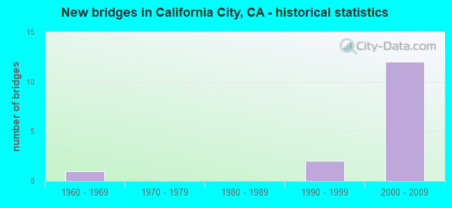
- New bridges - historical statistics
- 11960-1969
- 21990-1999
- 122000-2009


- Bridge Condition - Deck
- 33.3%Good
- 33.3%Satisfactory
- 16.7%Fair
- 16.7%Poor

- Bridge Condition - Superstructure
- 83.3%Good
- 16.7%Poor

- Bridge Condition - Channel
- 62.5%Excellent
- 37.5%Very good
Find on map >> Show street view
Structure Number: 50 0487L, Location: 09-KER-014-29.51 (Lat: 35.227289, Lng: -118.049592), Route carried "on" structure: State highway 14, Year Built: 1994, Status: Open, Structure Length: 1.52m (4.99ft), Average Daily Traffic: 3,350 (year 2014), Average Future Daily Traffic: 9,018 (year 2041), Features Intersected: PINE TREE WASH
Minimum Vertical Clearance: 30+ m (98+ ft), Kilometerpoint: 29.510, Lanes on structure: 2, Base Highway Network: Yes (, Subroute: 1), Owner: State Highway Agency, Approaching Roadway Width: 11.9m (39.0ft), Material/Design: Concrete continuous, Design/Construction: Culvert, Number Of Spans In Main Unit: 6, Length of Maximum Span: 2.4m (7.9ft)
Condition: Channel: Very good, Culverts: Good, Operating Rating: 54.1 metric tons, Method Used To Determine Operating Rating: Field evaluation and documented engineering judgment, Inventory Rating: 32.4 metric tons, Method Used To Determine Inventory Rating: Field evaluation and documented engineering judgment, Structural Evaluation: Better than present minimum criteria, Waterway Adequacy: Equal to present desirable criteria, Approach Roadway Alignment: Equal to present minimum criteria, Designated Inspection Frequency: Every 24 months, Inspection Date: April 2021
Find on map >> Show street view
Structure Number: 50 0487R, Location: 09-KER-014-29.51 (Lat: 35.227169, Lng: -118.049194), Route carried "on" structure: State highway 14, Year Built: 1994, Status: Open, Structure Length: 1.52m (4.99ft), Average Daily Traffic: 3,350 (year 2014), Average Future Daily Traffic: 9,018 (year 2041), Features Intersected: PINE TREE WASH
Minimum Vertical Clearance: 30+ m (98+ ft), Kilometerpoint: 29.510, Lanes on structure: 2, Base Highway Network: Yes (, Subroute: 1), Owner: State Highway Agency, Approaching Roadway Width: 11.9m (39.0ft), Material/Design: Concrete continuous, Design/Construction: Culvert, Number Of Spans In Main Unit: 6, Length of Maximum Span: 2.4m (7.9ft)
Condition: Channel: Very good, Culverts: Good, Operating Rating: 54.1 metric tons, Method Used To Determine Operating Rating: Field evaluation and documented engineering judgment, Inventory Rating: 32.4 metric tons, Method Used To Determine Inventory Rating: Field evaluation and documented engineering judgment, Structural Evaluation: Better than present minimum criteria, Waterway Adequacy: Equal to present desirable criteria, Approach Roadway Alignment: Equal to present desirable criteria, Designated Inspection Frequency: Every 24 months, Inspection Date: April 2021
Find on map >> Show street view
Structure Number: 50 0495L, Location: 09-KER-058-M111.78 (Lat: 35.094144, Lng: -118.133936), Route carried "on" structure: State highway 58, Year Built: 2003, Status: Open, Structure Length: 7.70m (25.26ft), Average Daily Traffic: 14,500 (year 2011), Truck Traffic: 37%, Average Future Daily Traffic: 20,953 (year 2040), Design Load: HS 20+Mod, Features Intersected: UNION PACIFIC RR (UP RR)
Minimum Vertical Clearance: 30+ m (98+ ft), Kilometerpoint: 111.780, Lanes on structure: 2, Base Highway Network: Yes (, Subroute: 3), Owner: State Highway Agency, Approaching Roadway Width: 11.8m (38.7ft), Skew: 1 degrees, Material/Design: Prestressed concrete continuous, Design/Construction: Box Beam or Girders - Multiple, Number Of Spans In Main Unit: 3, Length of Maximum Span: 30.8m (101.0ft), Curb-To-Curb Width: 11.8m (38.7ft), Out-to-Out Width: 12.8m (42.0ft)
Condition: Deck: Good, Superstructure: Good, Substructure: Good, Operating Rating: 54.1 metric tons, Method Used To Determine Operating Rating: Assigned rating based on Load Factor Design (LFD) reported in metric tons, Inventory Rating: 32.4 metric tons, Method Used To Determine Inventory Rating: Assigned rating based on Load Factor Design (LFD) reported in metric tons, Structural Evaluation: Better than present minimum criteria, Deck Geometry: Better than present minimum criteria, Underclear: Superior to present desirable criteria, Approach Roadway Alignment: Equal to present desirable criteria, Designated Inspection Frequency: Every 24 months, Inspection Date: June 2021, Deck Structure Type: Concrete Cast-file-Place
Find on map >> Show street view
Structure Number: 50 0498L, Location: 09-KER-014-19.00 (Lat: 35.098514, Lng: -118.144708), Route carried "on" structure: State highway 14, Year Built: 2003, Status: Open, Structure Length: 8.70m (28.54ft), Average Daily Traffic: 4,800 (year 2017), Truck Traffic: 13%, Average Future Daily Traffic: 9,175 (year 2041), Design Load: HS 20+Mod, Features Intersected: STATE ROUTE 58
Minimum Vertical Clearance: 30+ m (98+ ft), Kilometerpoint: 19.000, Lanes on structure: 3, Lanes under structure: 5, Base Highway Network: Yes (, Subroute: 1), Owner: State Highway Agency, Approaching Roadway Width: 15.4m (50.5ft), Material/Design: Prestressed concrete continuous, Design/Construction: Box Beam or Girders - Multiple, Number Of Spans In Main Unit: 2, Length of Maximum Span: 44.0m (144.4ft), Curb-To-Curb Width: 15.4m (50.5ft), Out-to-Out Width: 16.4m (53.8ft)
Condition: Deck: Satisfactory, Superstructure: Good, Substructure: Good, Operating Rating: 54.1 metric tons, Method Used To Determine Operating Rating: Assigned rating based on Load Factor Design (LFD) reported in metric tons, Inventory Rating: 32.4 metric tons, Method Used To Determine Inventory Rating: Assigned rating based on Load Factor Design (LFD) reported in metric tons, Structural Evaluation: Better than present minimum criteria, Deck Geometry: Equal to present minimum criteria, Underclear: Better than present minimum criteria, Approach Roadway Alignment: Equal to present desirable criteria, Designated Inspection Frequency: Every 24 months, Inspection Date: April 2021, Deck Structure Type: Concrete Cast-file-Place
Find on map >> Show street view
Structure Number: 50 0498R, Location: 09-KER-014-19.00 (Lat: 35.098378, Lng: -118.144411), Route carried "on" structure: State highway 14, Year Built: 2003, Status: Open, Structure Length: 8.70m (28.54ft), Average Daily Traffic: 4,800 (year 2017), Truck Traffic: 13%, Average Future Daily Traffic: 9,175 (year 2041), Design Load: HS 20+Mod, Features Intersected: STATE ROUTE 58
Minimum Vertical Clearance: 30+ m (98+ ft), Kilometerpoint: 19.000, Lanes on structure: 2, Lanes under structure: 5, Base Highway Network: Yes (, Subroute: 1), Owner: State Highway Agency, Approaching Roadway Width: 11.8m (38.7ft), Material/Design: Prestressed concrete continuous, Design/Construction: Box Beam or Girders - Multiple, Number Of Spans In Main Unit: 2, Length of Maximum Span: 44.0m (144.4ft), Curb-To-Curb Width: 11.8m (38.7ft), Out-to-Out Width: 12.8m (42.0ft)
Condition: Deck: Satisfactory, Superstructure: Good, Substructure: Good, Operating Rating: 54.1 metric tons, Method Used To Determine Operating Rating: Assigned rating based on Load Factor Design (LFD) reported in metric tons, Inventory Rating: 32.4 metric tons, Method Used To Determine Inventory Rating: Assigned rating based on Load Factor Design (LFD) reported in metric tons, Structural Evaluation: Better than present minimum criteria, Deck Geometry: Better than present minimum criteria, Underclear: Better than present minimum criteria, Approach Roadway Alignment: Equal to present desirable criteria, Designated Inspection Frequency: Every 24 months, Inspection Date: April 2021, Deck Structure Type: Concrete Cast-file-Place
Find on map >> Show street view
Structure Number: 50 0501R, Location: 09-KER-014-20.18 (Lat: 35.111858, Lng: -118.133947), Route carried "on" structure: State highway 14, Year Built: 2008, Status: Open, Structure Length: 4.70m (15.42ft), Average Daily Traffic: 4,800 (year 2017), Truck Traffic: 13%, Average Future Daily Traffic: 9,175 (year 2041), Design Load: HS 20+Mod, Features Intersected: CACHE CREEK
Minimum Vertical Clearance: 30+ m (98+ ft), Kilometerpoint: 20.180, Lanes on structure: 2, Base Highway Network: Yes (, Subroute: 1), Owner: State Highway Agency, Approaching Roadway Width: 11.7m (38.4ft), Skew: 3 degrees, Material/Design: Concrete, Design/Construction: Box Beam or Girders - Multiple, Number Of Spans In Main Unit: 1, Length of Maximum Span: 46.0m (150.9ft), Curb-To-Curb Width: 11.7m (38.4ft), Out-to-Out Width: 12.6m (41.3ft)
Condition: Deck: Fair, Superstructure: Good, Substructure: Good, Channel: Very good, Operating Rating: 54.1 metric tons, Method Used To Determine Operating Rating: Assigned rating based on Load Factor Design (LFD) reported in metric tons, Inventory Rating: 32.4 metric tons, Method Used To Determine Inventory Rating: Assigned rating based on Load Factor Design (LFD) reported in metric tons, Structural Evaluation: Better than present minimum criteria, Deck Geometry: Better than present minimum criteria, Waterway Adequacy: Equal to present desirable criteria, Approach Roadway Alignment: Equal to present desirable criteria, Designated Inspection Frequency: Every 24 months, Inspection Date: April 2021, Deck Structure Type: Concrete Cast-file-Place
Find on map >> Show street view
Structure Number: 50 0502, Location: 09-KER-014-21.16 (Lat: 35.125317, Lng: -118.124269), Route carried "on" structure: County highway , Year Built: 2008, Status: Open, Structure Length: 7.50m (24.61ft), Average Daily Traffic: 7,700 (year 2017), Truck Traffic: 2%, Average Future Daily Traffic: 3,635 (year 2041), Design Load: HS 20+Mod, Features Intersected: STATE ROUTE 14, Facility Carried by Structure: CALIFORNIA CITY BL
Minimum Vertical Clearance: 30+ m (98+ ft), Kilometerpoint: 0.000, Lanes on structure: 4, Lanes under structure: 5, Owner: State Highway Agency, Approaching Roadway Width: 24.3m (79.7ft), Skew: 3 degrees, Material/Design: Concrete continuous, Design/Construction: Box Beam or Girders - Multiple, Number Of Spans In Main Unit: 2, Length of Maximum Span: 37.5m (123.0ft), Curb or Sidewalk Widths: Left: 1.8m (5.9ft), Right: 0.0m, Curb-To-Curb Width: 22.8m (74.8ft), Out-to-Out Width: 25.0m (82.0ft)
Condition: Deck: Good, Superstructure: Good, Substructure: Good, Operating Rating: 54.1 metric tons, Method Used To Determine Operating Rating: Assigned rating based on Load Factor Design (LFD) reported in metric tons, Inventory Rating: 32.4 metric tons, Method Used To Determine Inventory Rating: Assigned rating based on Load Factor Design (LFD) reported in metric tons, Structural Evaluation: Better than present minimum criteria, Deck Geometry: Superior to present desirable criteria, Underclear: Superior to present desirable criteria, Approach Roadway Alignment: Equal to present desirable criteria, Designated Inspection Frequency: Every 24 months, Inspection Date: April 2021, Deck Structure Type: Concrete Cast-file-Place
Find on map >> Show street view
Structure Number: 50 0511, Location: 09-KER-014-22.35 (Lat: 35.140264, Lng: -118.113175), Route carried "on" structure: Ramp State highway 14, Year Built: 2008, Status: Open, Structure Length: 0.64m (2.10ft), Average Daily Traffic: 24 (year 2019), Truck Traffic: 1%, Average Future Daily Traffic: 31 (year 2041), Features Intersected: DRAINAGE DITCH, Facility Carried by Structure: ACCESS ROAD
Minimum Vertical Clearance: 30+ m (98+ ft), Kilometerpoint: 22.350, Lanes on structure: 2, Owner: State Highway Agency, Approaching Roadway Width: 7.2m (23.6ft), Material/Design: Concrete continuous, Design/Construction: Culvert, Number Of Spans In Main Unit: 2, Length of Maximum Span: 3.1m (10.2ft)
Condition: Channel: Excellent, Culverts: Good, Operating Rating: 54.1 metric tons, Method Used To Determine Operating Rating: Field evaluation and documented engineering judgment, Inventory Rating: 32.4 metric tons, Method Used To Determine Inventory Rating: Field evaluation and documented engineering judgment, Structural Evaluation: Better than present minimum criteria, Waterway Adequacy: Equal to present desirable criteria, Approach Roadway Alignment: Equal to present desirable criteria, Designated Inspection Frequency: Every 24 months, Inspection Date: April 2021
Find on map >> Show street view
Structure Number: 50 0512, Location: 09-KER-014-23.65 (Lat: 35.154786, Lng: -118.101825), Route carried "on" structure: Ramp State highway 14, Year Built: 2008, Status: Open, Structure Length: 0.89m (2.92ft), Average Daily Traffic: 24 (year 2019), Truck Traffic: 1%, Average Future Daily Traffic: 31 (year 2041), Features Intersected: DRAINAGE DITCH, Facility Carried by Structure: ACCESS ROAD
Minimum Vertical Clearance: 30+ m (98+ ft), Kilometerpoint: 23.650, Lanes on structure: 2, Owner: State Highway Agency, Approaching Roadway Width: 7.2m (23.6ft), Material/Design: Concrete, Design/Construction: Culvert, Number Of Spans In Main Unit: 2, Length of Maximum Span: 4.3m (14.1ft)
Condition: Channel: Excellent, Culverts: Good, Operating Rating: 54.1 metric tons, Method Used To Determine Operating Rating: Field evaluation and documented engineering judgment, Inventory Rating: 32.4 metric tons, Method Used To Determine Inventory Rating: Field evaluation and documented engineering judgment, Structural Evaluation: Better than present minimum criteria, Waterway Adequacy: Equal to present desirable criteria, Approach Roadway Alignment: Equal to present desirable criteria, Designated Inspection Frequency: Every 24 months, Inspection Date: April 2021
Find on map >> Show street view
Structure Number: 50 0513, Location: 09-KER-014-24.88 (Lat: 35.169581, Lng: -118.089878), Route carried "on" structure: Ramp State highway 14, Year Built: 2008, Status: Open, Structure Length: 0.89m (2.92ft), Average Daily Traffic: 24 (year 2019), Truck Traffic: 1%, Average Future Daily Traffic: 31 (year 2041), Features Intersected: DRAINAGE DITCH, Facility Carried by Structure: ACCESS ROAD
Minimum Vertical Clearance: 30+ m (98+ ft), Kilometerpoint: 24.880, Lanes on structure: 2, Owner: State Highway Agency, Approaching Roadway Width: 10.0m (32.8ft), Material/Design: Concrete continuous, Design/Construction: Culvert, Number Of Spans In Main Unit: 2, Length of Maximum Span: 4.3m (14.1ft)
Condition: Channel: Excellent, Culverts: Good, Operating Rating: 54.1 metric tons, Method Used To Determine Operating Rating: Field evaluation and documented engineering judgment, Inventory Rating: 32.4 metric tons, Method Used To Determine Inventory Rating: Field evaluation and documented engineering judgment, Structural Evaluation: Better than present minimum criteria, Waterway Adequacy: Equal to present desirable criteria, Approach Roadway Alignment: Equal to present desirable criteria, Designated Inspection Frequency: Every 24 months, Inspection Date: April 2021
Find on map >> Show street view
Structure Number: 50 0514, Location: 09-KER-014-25.76 (Lat: 35.180058, Lng: -118.080644), Route carried "on" structure: State highway 14, Year Built: 2008, Status: Open, Structure Length: 2.35m (7.71ft), Average Daily Traffic: 9,800 (year 2019), Truck Traffic: 13%, Average Future Daily Traffic: 17,117 (year 2041), Features Intersected: DUCK POND CREEK
Minimum Vertical Clearance: 30+ m (98+ ft), Kilometerpoint: 25.760, Lanes on structure: 4, Base Highway Network: Yes (, Subroute: 1), Owner: State Highway Agency, Approaching Roadway Width: 11.9m (39.0ft), Skew: 15 degrees, Material/Design: Concrete continuous, Design/Construction: Culvert, Number Of Spans In Main Unit: 3, Length of Maximum Span: 7.6m (24.9ft)
Condition: Channel: Excellent, Culverts: Good, Operating Rating: 54.1 metric tons, Method Used To Determine Operating Rating: Field evaluation and documented engineering judgment, Inventory Rating: 32.4 metric tons, Method Used To Determine Inventory Rating: Field evaluation and documented engineering judgment, Structural Evaluation: Better than present minimum criteria, Waterway Adequacy: Equal to present desirable criteria, Approach Roadway Alignment: Equal to present desirable criteria, Designated Inspection Frequency: Every 24 months, Inspection Date: April 2021
Find on map >> Show street view
Structure Number: 50C0059, Location: 1.3 MI E OF SR 58 (Lat: 35.122636, Lng: -118.179578), Route carried "on" structure: County highway , Year Built: 1966, Status: Open, Structure Length: 1.31m (4.30ft), Average Daily Traffic: 2,260 (year 2007), Truck Traffic: 5%, Average Future Daily Traffic: 3,842 (year 2040), Design Load: HS 20, Features Intersected: LOS ANGELES AQUEDUCT, Facility Carried by Structure: RANDSBURG CUTOFF
Minimum Vertical Clearance: 30+ m (98+ ft), Kilometerpoint: 0.000, Lanes on structure: 2, Owner: County Highway Agency, Approaching Roadway Width: 7.3m (24.0ft), Skew: 5 degrees, Material/Design: Concrete, Design/Construction: Slab, Number Of Spans In Main Unit: 1, Length of Maximum Span: 11.9m (39.0ft), Curb-To-Curb Width: 12.2m (40.0ft), Out-to-Out Width: 12.4m (40.7ft)
Condition: Deck: Poor, Superstructure: Poor, Substructure: Good, Channel: Excellent, Operating Rating: 70.0 metric tons, Method Used To Determine Operating Rating: Load Factor (LF), Inventory Rating: 41.8 metric tons, Method Used To Determine Inventory Rating: Load Factor (LF), Structural Evaluation: Meets minimum limits, Deck Geometry: Equal to present minimum criteria, Waterway Adequacy: Superior to present desirable criteria, Approach Roadway Alignment: Equal to present desirable criteria, Length Of Structure Improvement: 1.31m (4.30ft), Designated Inspection Frequency: Every 24 months, Inspection Date: November 2021, Bridge Improvement Cost: $162,000, Roadway Improvement Cost: $32,000, Total Project Cost: $272,000 ( Estimate for 2017), Deck Structure Type: Concrete Cast-file-Place
Find on map >> Show street view
Structure Number: 50 0498L, Location: 09-KER-014-19.00 (Lat: 35.098514, Lng: -118.144708), Route carried "under" structure: State highway 58, Year Built: 2003, Structure Length: 0. m, Average Daily Traffic: 19,600 (year 2014), Truck Traffic: 29%, Features Intersected: STATE ROUTE 58, Facility Carried by Structure: STATE ROUTE 14 SB
Minimum Vertical Clearance: 6.42m (21.06ft), Kilometerpoint: 111.120, Lanes on structure: 3, Lanes under structure: 5, Material/Design: Prestressed concrete continuous, Design/Construction: Box Beam or Girders - Multiple, Length of Maximum Span: 44.0m (144.4ft)
Find on map >> Show street view
Structure Number: 50 0498R, Location: 09-KER-014-19.00 (Lat: 35.098378, Lng: -118.144411), Route carried "under" structure: State highway 58, Year Built: 2003, Structure Length: 0. m, Average Daily Traffic: 19,600 (year 2014), Truck Traffic: 29%, Features Intersected: STATE ROUTE 58, Facility Carried by Structure: STATE ROUTE 14 NB
Minimum Vertical Clearance: 7.29m (23.92ft), Kilometerpoint: 111.120, Lanes on structure: 2, Lanes under structure: 5, Material/Design: Prestressed concrete continuous, Design/Construction: Box Beam or Girders - Multiple, Length of Maximum Span: 44.0m (144.4ft)
Find on map >> Show street view
Structure Number: 50 0502, Location: 09-KER-014-21.16 (Lat: 35.125317, Lng: -118.124269), Route carried "under" structure: State highway 14, Year Built: 2008, Structure Length: 0. m, Average Daily Traffic: 9,800 (year 2014), Truck Traffic: 13%, Features Intersected: STATE ROUTE 14, Facility Carried by Structure: CALIFORNIA CITY BL
Minimum Vertical Clearance: 5.71m (18.73ft), Kilometerpoint: 21.160, Lanes on structure: 4, Lanes under structure: 5, Material/Design: Concrete continuous, Design/Construction: Box Beam or Girders - Multiple, Length of Maximum Span: 37.5m (123.0ft)