Bridge Statistics for Carlock, Illinois (IL)
Condition, Traffic, Stress, Structural Evaluation, Project Costs
- National Bridge Inventory (NBI) Statistics
- 22Number of bridges
- 164ft / 50.0mTotal length
- 169,275Total average daily traffic
- 31,119Total average daily truck traffic
- National Bridge Inventory (NBI) Registered Bridges for Carlock
- No street view available for this location
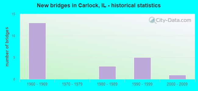
- New bridges - historical statistics
- 131960-1969
- 31980-1989
- 51990-1999
- 12000-2009


- Bridge Condition - Deck
- 16.7%Very good
- 16.7%Good
- 58.3%Satisfactory
- 8.3%Fair

- Bridge Condition - Superstructure
- 15.4%Very good
- 23.1%Good
- 38.5%Satisfactory
- 23.1%Fair

- Bridge Condition - Substructure
- 7.7%Very good
- 53.8%Good
- 15.4%Satisfactory
- 23.1%Fair

- Bridge Condition - Channel
- 33.3%Very good
- 46.7%Good
- 20.0%Satisfactory

- Bridge Condition - Culverts
- 40.0%Very good
- 60.0%Good
Find on map >> Show street view
Structure Number: 570043, Location: 7.2 MI E OF ILL 117 (Lat: 40.587506, Lng: -89.147111), Route carried "on" structure: Interstate 74, Year Built: 1964, Status: Open, Structure Length: 2.59m (8.50ft), Average Daily Traffic: 13,550 (year 2021), Truck Traffic: 19%, Average Future Daily Traffic: 14,633 (year 2032), Design Load: HS 20+Mod, Features Intersected: ROCK CREEK
Minimum Vertical Clearance: 30+ m (98+ ft), Kilometerpoint: 195.240, Lanes on structure: 2, Base Highway Network: Yes, Owner: State Highway Agency, Approaching Roadway Width: 12.2m (40.0ft), Material/Design: Concrete continuous, Design/Construction: Slab, Number Of Spans In Main Unit: 3, Length of Maximum Span: 9.5m (31.2ft), Curb-To-Curb Width: 11.9m (39.0ft), Out-to-Out Width: 13.5m (44.3ft)
Condition: Deck: Satisfactory, Superstructure: Satisfactory, Substructure: Good, Channel: Good, Operating Rating: 54.1 metric tons, Method Used To Determine Operating Rating: Load Factor (LF) rating reported by rating factor (RF) method using MS18 loading, Inventory Rating: 32.7 metric tons, Method Used To Determine Inventory Rating: Load Factor (LF) rating reported by rating factor (RF) method using MS18 loading, Structural Evaluation: Equal to present minimum criteria, Deck Geometry: Equal to present minimum criteria, Waterway Adequacy: Equal to present desirable criteria, Approach Roadway Alignment: Equal to present desirable criteria, Designated Inspection Frequency: Every 24 months, Inspection Date: August 2021, Deck Structure Type: Concrete Cast-file-Place, Wearing Surface/Protective System: Wearing Surface: Latex Concrete
Find on map >> Show street view
Structure Number: 570044, Location: 7.2 MI E OF ILL 117 (Lat: 40.587397, Lng: -89.147006), Route carried "on" structure: Interstate 74, Year Built: 1964, Status: Open, Structure Length: 2.59m (8.50ft), Average Daily Traffic: 13,550 (year 2021), Truck Traffic: 19%, Average Future Daily Traffic: 14,633 (year 2032), Design Load: HS 20+Mod, Features Intersected: ROCK CREEK
Minimum Vertical Clearance: 30+ m (98+ ft), Kilometerpoint: 195.256, Lanes on structure: 2, Base Highway Network: Yes, Owner: State Highway Agency, Approaching Roadway Width: 12.2m (40.0ft), Material/Design: Concrete continuous, Design/Construction: Slab, Number Of Spans In Main Unit: 3, Length of Maximum Span: 9.5m (31.2ft), Curb-To-Curb Width: 11.9m (39.0ft), Out-to-Out Width: 13.5m (44.3ft)
Condition: Deck: Satisfactory, Superstructure: Satisfactory, Substructure: Good, Channel: Good, Operating Rating: 54.1 metric tons, Method Used To Determine Operating Rating: Load Factor (LF) rating reported by rating factor (RF) method using MS18 loading, Inventory Rating: 32.7 metric tons, Method Used To Determine Inventory Rating: Load Factor (LF) rating reported by rating factor (RF) method using MS18 loading, Structural Evaluation: Equal to present minimum criteria, Deck Geometry: Equal to present minimum criteria, Waterway Adequacy: Equal to present desirable criteria, Approach Roadway Alignment: Equal to present desirable criteria, Designated Inspection Frequency: Every 24 months, Inspection Date: August 2021, Deck Structure Type: Concrete Cast-file-Place, Wearing Surface/Protective System: Wearing Surface: Latex Concrete
Find on map >> Show street view
Structure Number: 570102, Location: 7.70 MI E OF ILL 117 (Lat: 40.582089, Lng: -89.141819), Route carried "on" structure: County highway , Year Built: 1964, Status: Open, Structure Length: 9.00m (29.53ft), Average Daily Traffic: 775 (year 2020), Truck Traffic: 11%, Average Future Daily Traffic: 726 (year 2032), Design Load: HS 20, Features Intersected: I-74, Facility Carried by Structure: CARLOCK ROAD
Minimum Vertical Clearance: 30+ m (98+ ft), Kilometerpoint: 0.660, Lanes on structure: 2, Lanes under structure: 4, Owner: State Highway Agency, Approaching Roadway Width: 11.6m (38.1ft), Skew: 4 degrees, Material/Design: Steel continuous, Design/Construction: Stringer/Multi-beam, Number Of Spans In Main Unit: 4, Length of Maximum Span: 27.3m (89.6ft), Curb-To-Curb Width: 8.5m (27.9ft), Out-to-Out Width: 10.4m (34.1ft)
Condition: Deck: Fair, Superstructure: Fair, Substructure: Satisfactory, Operating Rating: 64.8 metric tons, Method Used To Determine Operating Rating: Load Factor (LF) rating reported by rating factor (RF) method using MS18 loading, Inventory Rating: 38.2 metric tons, Method Used To Determine Inventory Rating: Load Factor (LF) rating reported by rating factor (RF) method using MS18 loading, Structural Evaluation: Somewhat better than minimum adequacy, Deck Geometry: Somewhat better than minimum adequacy, Underclear: High priority of corrective action, Approach Roadway Alignment: Equal to present desirable criteria, Designated Inspection Frequency: Every 24 months, Inspection Date: August 2021, Deck Structure Type: Concrete Cast-file-Place, Wearing Surface/Protective System: Wearing Surface: Bituminous, Membrane: Built-up
Find on map >> Show street view
Structure Number: 570112, Location: 8.3 MI E OF ILL 117 (Lat: 40.575872, Lng: -89.133092), Route carried "on" structure: County highway , Year Built: 1964, Status: Open, Structure Length: 9.28m (30.45ft), Average Daily Traffic: 75 (year 2020), Truck Traffic: 7%, Average Future Daily Traffic: 112 (year 2032), Design Load: HS 15, Features Intersected: I-74, Facility Carried by Structure: TR 90
Minimum Vertical Clearance: 30+ m (98+ ft), Kilometerpoint: 0.225, Lanes on structure: 2, Lanes under structure: 4, Owner: State Highway Agency, Approaching Roadway Width: 5.8m (19.0ft), Skew: 4 degrees, Material/Design: Steel continuous, Design/Construction: Stringer/Multi-beam, Number Of Spans In Main Unit: 4, Length of Maximum Span: 28.4m (93.2ft), Curb or Sidewalk Widths: Left: 0.6m (2.0ft), Right: 0.6m (2.0ft), Curb-To-Curb Width: 7.3m (24.0ft), Out-to-Out Width: 9.1m (29.9ft)
Condition: Deck: Satisfactory, Superstructure: Fair, Substructure: Satisfactory, Operating Rating: 52.2 metric tons, Method Used To Determine Operating Rating: Allowable Stress (AS) rating reported by rating factor (RF) method using MS18 loading, Inventory Rating: 33.4 metric tons, Method Used To Determine Inventory Rating: Allowable Stress (AS) rating reported by rating factor (RF) method using MS18 loading, Structural Evaluation: Somewhat better than minimum adequacy, Deck Geometry: Equal to present minimum criteria, Underclear: Meets minimum limits, Approach Roadway Alignment: Better than present minimum criteria, Designated Inspection Frequency: Every 24 months, Inspection Date: August 2021, Deck Structure Type: Concrete Cast-file-Place
Find on map >> Show street view
Structure Number: 570113, Location: 6.65 MI E OF ILL 117 (Lat: 40.593319, Lng: -89.155119), Route carried "on" structure: County highway , Year Built: 1964, Status: Open, Structure Length: 8.74m (28.67ft), Average Daily Traffic: 75 (year 2020), Truck Traffic: 13%, Average Future Daily Traffic: 84 (year 2032), Design Load: HS 15, Features Intersected: I-74, Facility Carried by Structure: COUNTY ROAD TR 76
Minimum Vertical Clearance: 30+ m (98+ ft), Kilometerpoint: 0.306, Lanes on structure: 2, Lanes under structure: 4, Owner: State Highway Agency, Approaching Roadway Width: 6.1m (20.0ft), Skew: 4 degrees, Material/Design: Steel continuous, Design/Construction: Stringer/Multi-beam, Number Of Spans In Main Unit: 4, Length of Maximum Span: 26.8m (87.9ft), Curb-To-Curb Width: 7.3m (24.0ft), Out-to-Out Width: 9.1m (29.9ft)
Condition: Deck: Satisfactory, Superstructure: Satisfactory, Substructure: Good, Operating Rating: 54.1 metric tons, Method Used To Determine Operating Rating: Allowable Stress (AS) rating reported by rating factor (RF) method using MS18 loading, Inventory Rating: 35.3 metric tons, Method Used To Determine Inventory Rating: Allowable Stress (AS) rating reported by rating factor (RF) method using MS18 loading, Structural Evaluation: Equal to present minimum criteria, Deck Geometry: Equal to present minimum criteria, Underclear: High priority of corrective action, Approach Roadway Alignment: Better than present minimum criteria, Designated Inspection Frequency: Every 24 months, Inspection Date: August 2021, Deck Structure Type: Concrete Cast-file-Place
Find on map >> Show street view
Structure Number: 572035, Location: 9.1 MI E IL 117 (Lat: 40.586900, Lng: -89.138319), Route carried "on" structure: US 150, Year Built: 1999, Status: Open, Structure Length: 0.72m (2.36ft), Average Daily Traffic: 1,050 (year 2021), Truck Traffic: 17%, Average Future Daily Traffic: 1,173 (year 2032), Features Intersected: ROCK CREEK
Minimum Vertical Clearance: 30+ m (98+ ft), Kilometerpoint: 196.592, Lanes on structure: 2, Owner: State Highway Agency, Approaching Roadway Width: 7.3m (24.0ft), Material/Design: Concrete, Design/Construction: Culvert, Number Of Spans In Main Unit: 2, Length of Maximum Span: 3.3m (10.8ft)
Condition: Channel: Good, Culverts: Good, Operating Rating: 57.3 metric tons, Method Used To Determine Operating Rating: Load Factor (LF) rating reported by rating factor (RF) method using MS18 loading, Inventory Rating: 34.3 metric tons, Method Used To Determine Inventory Rating: Load Factor (LF) rating reported by rating factor (RF) method using MS18 loading, Structural Evaluation: Better than present minimum criteria, Waterway Adequacy: Equal to present desirable criteria, Approach Roadway Alignment: Equal to present desirable criteria, Designated Inspection Frequency: Every 48 months, Inspection Date: October 2019
Find on map >> Show street view
Structure Number: 572036, Location: 9.82 MI E IL 117 (Lat: 40.582439, Lng: -89.126861), Route carried "on" structure: US 150, Year Built: 1999, Status: Open, Structure Length: 0.72m (2.36ft), Average Daily Traffic: 2,300 (year 2021), Truck Traffic: 20%, Average Future Daily Traffic: 2,681 (year 2032), Features Intersected: ROCK CREEK
Minimum Vertical Clearance: 30+ m (98+ ft), Kilometerpoint: 197.831, Lanes on structure: 2, Owner: State Highway Agency, Approaching Roadway Width: 9.2m (30.2ft), Material/Design: Concrete, Design/Construction: Culvert, Number Of Spans In Main Unit: 2, Length of Maximum Span: 3.3m (10.8ft)
Condition: Channel: Good, Culverts: Good, Operating Rating: 52.2 metric tons, Method Used To Determine Operating Rating: Load Factor (LF) rating reported by rating factor (RF) method using MS18 loading, Inventory Rating: 32.4 metric tons, Method Used To Determine Inventory Rating: Load Factor (LF) rating reported by rating factor (RF) method using MS18 loading, Structural Evaluation: Better than present minimum criteria, Waterway Adequacy: Equal to present desirable criteria, Approach Roadway Alignment: Equal to present desirable criteria, Designated Inspection Frequency: Every 48 months, Inspection Date: October 2019
Find on map >> Show street view
Structure Number: 574026, Location: 1.2 MI WS CARLOCK (Lat: 40.563722, Lng: -89.154400), Route carried "on" structure: County highway , Year Built: 1993, Status: Open, Structure Length: 0.87m (2.85ft), Average Daily Traffic: 75 (year 2020), Truck Traffic: 13%, Average Future Daily Traffic: 84 (year 2032), Design Load: HS 20, Features Intersected: BR ROCK CREEK, Facility Carried by Structure: TR 76
Minimum Vertical Clearance: 30+ m (98+ ft), Kilometerpoint: 3.621, Lanes on structure: 2, Owner: Town or Township Highway Agency, Approaching Roadway Width: 4.9m (16.1ft), Skew: 3 degrees, Material/Design: Concrete, Design/Construction: Culvert, Number Of Spans In Main Unit: 2, Length of Maximum Span: 3.6m (11.8ft), Curb-To-Curb Width: 9.1m (29.9ft)
Condition: Channel: Very good, Culverts: Very good, Operating Rating: 44.1 metric tons, Method Used To Determine Operating Rating: Assigned rating based on Load Factor Design (LFD) reported by rating factor (RF) using MS18 loading, Inventory Rating: 32.4 metric tons, Method Used To Determine Inventory Rating: Assigned rating based on Load Factor Design (LFD) reported by rating factor (RF) using MS18 loading, Structural Evaluation: Equal to present desirable criteria, Deck Geometry: Better than present minimum criteria, Waterway Adequacy: Equal to present desirable criteria, Approach Roadway Alignment: Equal to present desirable criteria, Designated Inspection Frequency: Every 48 months, Inspection Date: April 2018, Wearing Surface/Protective System: Wearing Surface: Gravel
Find on map >> Show street view
Structure Number: 57403, Location: 2.0 MI W CARLOCK (Lat: 40.579972, Lng: -89.172483), Route carried "on" structure: County highway , Year Built: 2007, Status: Open, Structure Length: 1.04m (3.41ft), Average Daily Traffic: 300 (year 2020), Truck Traffic: 17%, Average Future Daily Traffic: 419 (year 2032), Design Load: HS 20, Features Intersected: BRANCH ROCK CREEK, Facility Carried by Structure: FAS 488
Minimum Vertical Clearance: 30+ m (98+ ft), Kilometerpoint: 3.476, Lanes on structure: 2, Owner: County Highway Agency, Approaching Roadway Width: 6.7m (22.0ft), Material/Design: Concrete, Design/Construction: Frame, Number Of Spans In Main Unit: 1, Length of Maximum Span: 9.8m (32.2ft), Curb-To-Curb Width: 12.9m (42.3ft), Out-to-Out Width: 12.9m (42.3ft)
Condition: Superstructure: Good, Substructure: Good, Channel: Good, Operating Rating: 44.1 metric tons, Method Used To Determine Operating Rating: Assigned rating based on Load Factor Design (LFD) reported by rating factor (RF) using MS18 loading, Inventory Rating: 32.4 metric tons, Method Used To Determine Inventory Rating: Assigned rating based on Load Factor Design (LFD) reported by rating factor (RF) using MS18 loading, Structural Evaluation: Better than present minimum criteria, Deck Geometry: Superior to present desirable criteria, Waterway Adequacy: Equal to present desirable criteria, Approach Roadway Alignment: Equal to present desirable criteria, Designated Inspection Frequency: Every 48 months, Inspection Date: March 2018
Find on map >> Show street view
Structure Number: 5758, Location: 3.0 MI NE CARLOCK (Lat: 40.613231, Lng: -89.092206), Route carried "on" structure: County highway , Year Built: 1964, Status: Open, Structure Length: 1.71m (5.61ft), Average Daily Traffic: 50 (year 2020), Average Future Daily Traffic: 66 (year 2032), Design Load: HS 15, Features Intersected: BR MACKINAW RIVER, Facility Carried by Structure: TR 124
Minimum Vertical Clearance: 30+ m (98+ ft), Kilometerpoint: 1.529, Lanes on structure: 2, Owner: Town or Township Highway Agency, Approaching Roadway Width: 4.3m (14.1ft), Material/Design: Concrete continuous, Design/Construction: Slab, Number Of Spans In Main Unit: 3, Length of Maximum Span: 6.1m (20.0ft), Curb-To-Curb Width: 7.3m (24.0ft), Out-to-Out Width: 7.9m (25.9ft)
Condition: Deck: Good, Superstructure: Good, Substructure: Good, Channel: Very good, Operating Rating: 38.9 metric tons, Method Used To Determine Operating Rating: Allowable Stress (AS) rating reported by rating factor (RF) method using MS18 loading, Inventory Rating: 23.3 metric tons, Method Used To Determine Inventory Rating: Allowable Stress (AS) rating reported by rating factor (RF) method using MS18 loading, Structural Evaluation: Equal to present minimum criteria, Deck Geometry: Equal to present minimum criteria, Waterway Adequacy: Equal to present desirable criteria, Approach Roadway Alignment: Equal to present desirable criteria, Designated Inspection Frequency: Every 24 months, Inspection Date: March 2020, Deck Structure Type: Concrete Cast-file-Place
Find on map >> Show street view
Structure Number: 575804, Location: CHURCH ST IN CARLOCK (Lat: 40.583733, Lng: -89.128575), Route carried "on" structure: City street , Year Built: 1967, Status: Open, Structure Length: 0.76m (2.49ft), Average Daily Traffic: 475 (year 2020), Truck Traffic: 7%, Average Future Daily Traffic: 500 (year 2017), Design Load: H 15, Features Intersected: ROCK CREEK, Facility Carried by Structure: CHURCH ST
Minimum Vertical Clearance: 30+ m (98+ ft), Kilometerpoint: 0.644, Lanes on structure: 2, Owner: City or Municipal Highway Agency, Approaching Roadway Width: 7.3m (24.0ft), Skew: 2 degrees, Material/Design: Concrete, Design/Construction: Slab, Number Of Spans In Main Unit: 1, Length of Maximum Span: 6.7m (22.0ft), Curb-To-Curb Width: 7.3m (24.0ft), Out-to-Out Width: 8.0m (26.2ft)
Condition: Deck: Very good, Superstructure: Very good, Substructure: Fair, Channel: Good, Operating Rating: 46.8 metric tons, Method Used To Determine Operating Rating: Allowable Stress (AS), Inventory Rating: 28.2 metric tons, Method Used To Determine Inventory Rating: Allowable Stress (AS), Structural Evaluation: Somewhat better than minimum adequacy, Deck Geometry: Meets minimum limits, Waterway Adequacy: Equal to present minimum criteria, Approach Roadway Alignment: Equal to present desirable criteria, Designated Inspection Frequency: Every 24 months, Inspection Date: October 2021, Deck Structure Type: Concrete Cast-file-Place
Find on map >> Show street view
Structure Number: 575805, Location: 3.0 MI NE CARLOCK (Lat: 40.604328, Lng: -89.081514), Route carried "on" structure: County highway , Year Built: 1989, Status: Open, Structure Length: 0.84m (2.76ft), Average Daily Traffic: 50 (year 2020), Average Future Daily Traffic: 56 (year 2032), Design Load: HS 20, Features Intersected: DENMAN CREEK, Facility Carried by Structure: TR 138
Minimum Vertical Clearance: 30+ m (98+ ft), Kilometerpoint: 0.901, Lanes on structure: 2, Owner: Town or Township Highway Agency, Approaching Roadway Width: 8.5m (27.9ft), Skew: 3 degrees, Material/Design: Concrete continuous, Design/Construction: Culvert, Number Of Spans In Main Unit: 2, Length of Maximum Span: 3.9m (12.8ft)
Condition: Channel: Very good, Culverts: Very good, Operating Rating: 44.4 metric tons, Method Used To Determine Operating Rating: Assigned rating based on Load Factor Design (LFD) reported by rating factor (RF) using MS18 loading, Inventory Rating: 32.4 metric tons, Method Used To Determine Inventory Rating: Assigned rating based on Load Factor Design (LFD) reported by rating factor (RF) using MS18 loading, Structural Evaluation: Equal to present desirable criteria, Waterway Adequacy: Equal to present desirable criteria, Approach Roadway Alignment: Equal to present desirable criteria, Designated Inspection Frequency: Every 48 months, Inspection Date: June 2019
Find on map >> Show street view
Structure Number: 575806, Location: 3.0 MI NE CARLOCK (Lat: 40.612483, Lng: -89.090094), Route carried "on" structure: County highway , Year Built: 1995, Status: Open, Structure Length: 2.65m (8.69ft), Average Daily Traffic: 450 (year 2020), Truck Traffic: 16%, Average Future Daily Traffic: 559 (year 2032), Design Load: HS 20, Features Intersected: DENMAN CREEK, Facility Carried by Structure: FAS 472
Minimum Vertical Clearance: 30+ m (98+ ft), Kilometerpoint: 3.782, Lanes on structure: 2, Owner: County Highway Agency, Approaching Roadway Width: 6.1m (20.0ft), Skew: 2 degrees, Material/Design: Concrete continuous, Design/Construction: Slab, Number Of Spans In Main Unit: 3, Length of Maximum Span: 9.8m (32.2ft), Curb-To-Curb Width: 8.5m (27.9ft), Out-to-Out Width: 9.3m (30.5ft)
Condition: Deck: Good, Superstructure: Good, Substructure: Good, Channel: Very good, Operating Rating: 53.8 metric tons, Method Used To Determine Operating Rating: Load Factor (LF) rating reported by rating factor (RF) method using MS18 loading, Inventory Rating: 32.4 metric tons, Method Used To Determine Inventory Rating: Load Factor (LF) rating reported by rating factor (RF) method using MS18 loading, Structural Evaluation: Better than present minimum criteria, Deck Geometry: Somewhat better than minimum adequacy, Waterway Adequacy: Better than present minimum criteria, Approach Roadway Alignment: Equal to present desirable criteria, Designated Inspection Frequency: Every 48 months, Inspection Date: November 2018, Deck Structure Type: Concrete Cast-file-Place
Find on map >> Show street view
Structure Number: 575807, Location: 1 MI W CARLOCK (Lat: 40.587867, Lng: -89.154992), Route carried "on" structure: County highway , Year Built: 1999, Status: Open, Structure Length: 2.85m (9.35ft), Average Daily Traffic: 75 (year 2020), Truck Traffic: 13%, Average Future Daily Traffic: 84 (year 2032), Design Load: HS 20, Features Intersected: ROCK CREEK, Facility Carried by Structure: TR 76
Minimum Vertical Clearance: 30+ m (98+ ft), Kilometerpoint: 0.949, Lanes on structure: 2, Owner: Town or Township Highway Agency, Approaching Roadway Width: 5.2m (17.1ft), Material/Design: Concrete continuous, Design/Construction: Slab, Number Of Spans In Main Unit: 3, Length of Maximum Span: 10.7m (35.1ft), Curb-To-Curb Width: 7.9m (25.9ft), Out-to-Out Width: 7.9m (25.9ft)
Condition: Deck: Very good, Superstructure: Very good, Substructure: Very good, Channel: Very good, Operating Rating: 44.1 metric tons, Method Used To Determine Operating Rating: Assigned rating based on Load Factor Design (LFD) reported by rating factor (RF) using MS18 loading, Inventory Rating: 32.4 metric tons, Method Used To Determine Inventory Rating: Assigned rating based on Load Factor Design (LFD) reported by rating factor (RF) using MS18 loading, Structural Evaluation: Equal to present desirable criteria, Deck Geometry: Equal to present minimum criteria, Waterway Adequacy: Equal to present desirable criteria, Approach Roadway Alignment: Equal to present desirable criteria, Designated Inspection Frequency: Every 48 months, Inspection Date: Febuary 2021, Deck Structure Type: Concrete Cast-file-Place, Wearing Surface/Protective System: Deck Protection: Epoxy Coated Reinforcing
Find on map >> Show street view
Structure Number: 578539, Location: W OF CARLOCK (Lat: 40.583625, Lng: -89.143406), Route carried "on" structure: Interstate 74, Year Built: 1966, Status: Open, Structure Length: 0.91m (2.99ft), Average Daily Traffic: 27,100 (year 2021), Truck Traffic: 19%, Average Future Daily Traffic: 29,265 (year 2032), Features Intersected: DITCH
Minimum Vertical Clearance: 30+ m (98+ ft), Kilometerpoint: 195.804, Lanes on structure: 4, Base Highway Network: Yes, Owner: State Highway Agency, Approaching Roadway Width: 27.4m (89.9ft), Skew: 15 degrees, Material/Design: Concrete, Design/Construction: Culvert, Number Of Spans In Main Unit: 3, Length of Maximum Span: 2.1m (6.9ft)
Condition: Channel: Satisfactory, Culverts: Good, Operating Rating: 44.1 metric tons, Method Used To Determine Operating Rating: Load Factor (LF) rating reported by rating factor (RF) method using MS18 loading, Inventory Rating: 32.4 metric tons, Method Used To Determine Inventory Rating: Load Factor (LF) rating reported by rating factor (RF) method using MS18 loading, Structural Evaluation: Better than present minimum criteria, Waterway Adequacy: Equal to present desirable criteria, Approach Roadway Alignment: Equal to present desirable criteria, Designated Inspection Frequency: Every 24 months, Inspection Date: September 2020
Find on map >> Show street view
Structure Number: 102302, Location: 4 MI N CARLOCK (Lat: 40.629875, Lng: -89.106553), Route carried "on" structure: County highway , Year Built: 1962, Status: Open, Structure Length: 1.13m (3.71ft), Average Daily Traffic: 200 (year 2020), Truck Traffic: 10%, Average Future Daily Traffic: 302 (year 2032), Design Load: HS 15, Features Intersected: DENMAN CREEK, Facility Carried by Structure: FAS 1360 CH 9
Minimum Vertical Clearance: 30+ m (98+ ft), Kilometerpoint: 17.541, Lanes on structure: 2, Owner: County Highway Agency, Approaching Roadway Width: 8.5m (27.9ft), Skew: 3 degrees, Material/Design: Steel, Design/Construction: Stringer/Multi-beam, Number Of Spans In Main Unit: 1, Length of Maximum Span: 11.0m (36.1ft), Curb-To-Curb Width: 8.5m (27.9ft), Out-to-Out Width: 9.9m (32.5ft)
Condition: Deck: Satisfactory, Superstructure: Fair, Substructure: Fair, Channel: Satisfactory, Operating Rating: 43.4 metric tons, Method Used To Determine Operating Rating: Allowable Stress (AS) rating reported by rating factor (RF) method using MS18 loading, Inventory Rating: 28.8 metric tons, Method Used To Determine Inventory Rating: Allowable Stress (AS) rating reported by rating factor (RF) method using MS18 loading, Structural Evaluation: Somewhat better than minimum adequacy, Deck Geometry: Equal to present minimum criteria, Waterway Adequacy: Equal to present desirable criteria, Approach Roadway Alignment: Equal to present desirable criteria, Designated Inspection Frequency: Every 24 months, Inspection Date: June 2020, Deck Structure Type: Concrete Cast-file-Place, Wearing Surface/Protective System: Wearing Surface: Bituminous
Find on map >> Show street view
Structure Number: 102314, Location: 7 MI S SECOR (Lat: 40.640800, Lng: -89.125681), Route carried "on" structure: County highway , Year Built: 1980, Status: Open, Structure Length: 2.62m (8.60ft), Average Daily Traffic: 50 (year 2020), Average Future Daily Traffic: 55 (year 2032), Design Load: HS 20, Features Intersected: DENMAN CREEK, Facility Carried by Structure: TR 251
Minimum Vertical Clearance: 30+ m (98+ ft), Kilometerpoint: 1.448, Lanes on structure: 2, Owner: Town or Township Highway Agency, Approaching Roadway Width: 6.1m (20.0ft), Skew: 1 degrees, Material/Design: Prestressed concrete, Design/Construction: Slab, Number Of Spans In Main Unit: 3, Length of Maximum Span: 8.5m (27.9ft), Curb-To-Curb Width: 8.0m (26.2ft), Out-to-Out Width: 8.0m (26.2ft)
Condition: Deck: Satisfactory, Superstructure: Satisfactory, Substructure: Good, Channel: Good, Operating Rating: 44.4 metric tons, Method Used To Determine Operating Rating: Assigned rating based on Load Factor Design (LFD) reported by rating factor (RF) using MS18 loading, Inventory Rating: 32.4 metric tons, Method Used To Determine Inventory Rating: Assigned rating based on Load Factor Design (LFD) reported by rating factor (RF) using MS18 loading, Structural Evaluation: Equal to present minimum criteria, Deck Geometry: Equal to present minimum criteria, Waterway Adequacy: Equal to present desirable criteria, Approach Roadway Alignment: Equal to present desirable criteria, Designated Inspection Frequency: Every 24 months, Inspection Date: Febuary 2021, Deck Structure Type: Concrete Precast Panels, Wearing Surface/Protective System: Wearing Surface: Gravel
Find on map >> Show street view
Structure Number: 102315, Location: 2225E 290N (Lat: 40.631103, Lng: -89.116106), Route carried "on" structure: County highway , Year Built: 1982, Status: Open, Structure Length: 1.03m (3.38ft), Average Daily Traffic: 75 (year 2020), Average Future Daily Traffic: 82 (year 2032), Design Load: HS 20, Features Intersected: DENMAN CREEK, Facility Carried by Structure: TR 192
Minimum Vertical Clearance: 30+ m (98+ ft), Kilometerpoint: 2.285, Lanes on structure: 2, Owner: Town or Township Highway Agency, Approaching Roadway Width: 5.2m (17.1ft), Material/Design: Concrete, Design/Construction: Channel Beam, Number Of Spans In Main Unit: 1, Length of Maximum Span: 9.5m (31.2ft), Curb-To-Curb Width: 8.0m (26.2ft), Out-to-Out Width: 8.0m (26.2ft)
Condition: Deck: Satisfactory, Superstructure: Satisfactory, Substructure: Fair, Channel: Satisfactory, Operating Rating: 44.4 metric tons, Method Used To Determine Operating Rating: Assigned rating based on Load Factor Design (LFD) reported by rating factor (RF) using MS18 loading, Inventory Rating: 32.4 metric tons, Method Used To Determine Inventory Rating: Assigned rating based on Load Factor Design (LFD) reported by rating factor (RF) using MS18 loading, Structural Evaluation: Somewhat better than minimum adequacy, Deck Geometry: Equal to present minimum criteria, Waterway Adequacy: Equal to present desirable criteria, Approach Roadway Alignment: Equal to present desirable criteria, Designated Inspection Frequency: Every 24 months, Inspection Date: June 2020, Deck Structure Type: Concrete Precast Panels, Wearing Surface/Protective System: Wearing Surface: Gravel
Find on map >> Show street view
Structure Number: 570102, Location: 7.70 MI E OF ILL 117 (Lat: 40.582089, Lng: -89.141819), Route carried "under" structure: Interstate 74, Year Built: 1964, Structure Length: 0. m, Average Daily Traffic: 27,300 (year 2021), Truck Traffic: 18%, Features Intersected: I-74, Facility Carried by Structure: CARLOCK ROAD
Minimum Vertical Clearance: 5.00m (16.40ft), Kilometerpoint: 195.981, Lanes on structure: 2, Lanes under structure: 4, Material/Design: Steel continuous, Design/Construction: Stringer/Multi-beam, Length of Maximum Span: 27.3m (89.6ft)
Find on map >> Show street view
Structure Number: 570112, Location: 8.3 MI E OF ILL 117 (Lat: 40.575872, Lng: -89.133092), Route carried "under" structure: Interstate 74, Year Built: 1964, Structure Length: 0. m, Average Daily Traffic: 27,300 (year 2021), Truck Traffic: 18%, Features Intersected: I-74, Facility Carried by Structure: TR 90
Minimum Vertical Clearance: 4.93m (16.17ft), Kilometerpoint: 196.946, Lanes on structure: 2, Lanes under structure: 4, Material/Design: Steel continuous, Design/Construction: Stringer/Multi-beam, Length of Maximum Span: 28.4m (93.2ft)
Find on map >> Show street view
Structure Number: 570113, Location: 6.65 MI E OF ILL 117 (Lat: 40.593319, Lng: -89.155119), Route carried "under" structure: Interstate 74, Year Built: 1964, Structure Length: 0. m, Average Daily Traffic: 27,100 (year 2021), Truck Traffic: 19%, Features Intersected: I-74, Facility Carried by Structure: COUNTY ROAD TR 76
Minimum Vertical Clearance: 5.00m (16.40ft), Kilometerpoint: 194.226, Lanes on structure: 2, Lanes under structure: 4, Material/Design: Steel continuous, Design/Construction: Stringer/Multi-beam, Length of Maximum Span: 26.8m (87.9ft)
Find on map >> Show street view
Structure Number: 570114, Location: 6 MILES W OF I-55 (Lat: 40.565639, Lng: -89.118431), Route carried "under" structure: Interstate 74, Year Built: 1964, Structure Length: 0. m, Average Daily Traffic: 27,300 (year 2021), Truck Traffic: 18%, Features Intersected: I-74, Facility Carried by Structure: TR 104
Minimum Vertical Clearance: 4.88m (16.01ft), Kilometerpoint: 198.620, Lanes on structure: 2, Lanes under structure: 4, Material/Design: Steel continuous, Design/Construction: Stringer/Multi-beam, Length of Maximum Span: 28.5m (93.5ft)