Bridge Statistics for Caruthersville, Missouri (MO)
Condition, Traffic, Stress, Structural Evaluation, Project Costs
- National Bridge Inventory (NBI) Statistics
- 19Number of bridges
- 843ft / 257mTotal length
- 82,428Total average daily traffic
- 28,880Total average daily truck traffic
- National Bridge Inventory (NBI) Registered Bridges for Caruthersville
- No street view available for this location
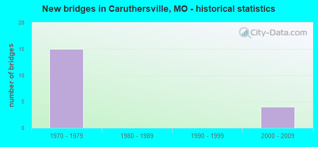
- New bridges - historical statistics
- 151970-1979
- 42000-2009

- Reconstructed bridges - Historical Statistics
- 41970-1979
- 11980-1989
- 01990-1999
- 12000-2009


- Bridge Condition - Deck
- 62.5%Good
- 37.5%Satisfactory

- Bridge Condition - Superstructure
- 37.5%Good
- 37.5%Satisfactory
- 25.0%Fair

- Bridge Condition - Substructure
- 12.5%Very good
- 37.5%Good
- 37.5%Satisfactory
- 12.5%Fair

- Bridge Condition - Channel
- 16.7%Very good
- 50.0%Good
- 33.3%Fair

- Bridge Condition - Culverts
- 33.3%Very good
- 33.3%Good
- 33.3%Satisfactory
Find on map >> Show street view
Structure Number: 1396, Location: S 11 T 17 N R 13 E (Lat: 36.118394, Lng: -89.615075), Route carried "on" structure: Interstate 155, Year Built: 1975, Year Reconstructed: 1987, Status: Open, Structure Length: 216.47m (710.20ft), Average Daily Traffic: 11,689 (year 2021), Truck Traffic: 35%, Average Future Daily Traffic: 21,625 (year 2041), Design Load: HS 20+Mod, Features Intersected: MISSISSIPPI RVR, COUNTY
Minimum Vertical Clearance: 5.33m (17.49ft), Kilometerpoint: 16.317, Lanes on structure: 4, Lanes under structure: 2, Base Highway Network: Yes, Owner: State Highway Agency, Approaching Roadway Width: 23.2m (76.1ft), Skew: 20 degrees, Navigation Control: Yes ( Vertical Clearance: 15.8m (51.8ft), Horizontal Clearance: 275.8m (904.9ft)), Material/Design: Steel continuous, Design/Construction: Truss - Thru, Number Of Spans In Main Unit: 2, Number Of Approach Spans: 57, Length of Maximum Span: 280.4m (919.9ft), Curb-To-Curb Width: 23.8m (78.1ft), Out-to-Out Width: 24.6m (80.7ft)
Condition: Deck: Satisfactory, Superstructure: Satisfactory, Substructure: Satisfactory, Channel: Fair, Operating Rating: 47.7 metric tons, Method Used To Determine Operating Rating: Load Factor (LF), Inventory Rating: 28.8 metric tons, Method Used To Determine Inventory Rating: Load Factor (LF), Structural Evaluation: Equal to present minimum criteria, Deck Geometry: Superior to present desirable criteria, Underclear: Meets minimum limits, Waterway Adequacy: Equal to present desirable criteria, Approach Roadway Alignment: Equal to present desirable criteria, Designated Inspection Frequency: Every 24 months, Critical Feature Inspection Frequency: Every 24 months, Underwater Inspection Frequency: Every 60 months, Inspection Date: March 2021, Critical Feature Inspection Date: March 2021, Underwater Inspection Date: August 2021, Deck Structure Type: Concrete Cast-file-Place, Wearing Surface/Protective System: Wearing Surface: Low Slump Concrete
Find on map >> Show street view
Structure Number: 2084, Location: S 19 T 18 N R 13 E (Lat: 36.176250, Lng: -89.693400), Route carried "on" structure: State highway D, Year Built: 1974, Year Reconstructed: 1984, Status: Open, Structure Length: 9.72m (31.89ft), Average Daily Traffic: 4,316 (year 2021), Truck Traffic: 11%, Average Future Daily Traffic: 6,474 (year 2041), Design Load: H 20, Features Intersected: IS 155
Minimum Vertical Clearance: 30+ m (98+ ft), Kilometerpoint: 10.338, Lanes on structure: 2, Lanes under structure: 6, Owner: State Highway Agency, Approaching Roadway Width: 7.3m (24.0ft), Skew: 4 degrees, Material/Design: Steel continuous, Design/Construction: Stringer/Multi-beam, Number Of Spans In Main Unit: 2, Number Of Approach Spans: 2, Length of Maximum Span: 34.1m (111.9ft), Curb-To-Curb Width: 13.4m (44.0ft), Out-to-Out Width: 14.3m (46.9ft)
Condition: Deck: Good, Superstructure: Fair, Substructure: Fair, Operating Rating: 45.9 metric tons, Method Used To Determine Operating Rating: Load Factor (LF), Inventory Rating: 27.9 metric tons, Method Used To Determine Inventory Rating: Load Factor (LF), Structural Evaluation: Somewhat better than minimum adequacy, Deck Geometry: Better than present minimum criteria, Underclear: Equal to present minimum criteria, Approach Roadway Alignment: Equal to present desirable criteria, Designated Inspection Frequency: Every 24 months, Other Special Inspection Frequency: Every 24 months, Inspection Date: Febuary 2022, Other Special Inspection Date: Febuary 2022, Deck Structure Type: Concrete Cast-file-Place, Wearing Surface/Protective System: Wearing Surface: Low Slump Concrete
Find on map >> Show street view
Structure Number: 2085, Location: S 32 T 18 N R 13 E (Lat: 36.151519, Lng: -89.663617), Route carried "on" structure: State highway 84, Year Built: 1974, Year Reconstructed: 1984, Status: Open, Structure Length: 8.60m (28.22ft), Average Daily Traffic: 1,882 (year 2021), Truck Traffic: 5%, Average Future Daily Traffic: 3,199 (year 2041), Design Load: H 20, Features Intersected: IS 155
Minimum Vertical Clearance: 30+ m (98+ ft), Kilometerpoint: 48.512, Lanes on structure: 2, Lanes under structure: 4, Owner: State Highway Agency, Approaching Roadway Width: 13.4m (44.0ft), Skew: 3 degrees, Material/Design: Steel continuous, Design/Construction: Stringer/Multi-beam, Number Of Spans In Main Unit: 2, Number Of Approach Spans: 2, Length of Maximum Span: 30.2m (99.1ft), Curb-To-Curb Width: 13.4m (44.0ft), Out-to-Out Width: 14.3m (46.9ft)
Condition: Deck: Good, Superstructure: Fair, Substructure: Satisfactory, Operating Rating: 44.1 metric tons, Method Used To Determine Operating Rating: Load Factor (LF), Inventory Rating: 26.1 metric tons, Method Used To Determine Inventory Rating: Load Factor (LF), Structural Evaluation: Somewhat better than minimum adequacy, Deck Geometry: Equal to present desirable criteria, Underclear: Somewhat better than minimum adequacy, Approach Roadway Alignment: Equal to present minimum criteria, Designated Inspection Frequency: Every 24 months, Other Special Inspection Frequency: Every 24 months, Inspection Date: Febuary 2022, Other Special Inspection Date: Febuary 2022, Deck Structure Type: Concrete Cast-file-Place, Wearing Surface/Protective System: Wearing Surface: Low Slump Concrete
Find on map >> Show street view
Structure Number: 211, Location: S 24 T 18 N R 12 E (Lat: 36.183650, Lng: -89.701008), Route carried "on" structure: Interstate 155, Year Built: 1974, Year Reconstructed: 1984, Status: Open, Structure Length: 5.33m (17.49ft), Average Daily Traffic: 4,311 (year 2021), Truck Traffic: 38%, Average Future Daily Traffic: 7,975 (year 2041), Design Load: HS 20+Mod, Features Intersected: CRD 337
Minimum Vertical Clearance: 30+ m (98+ ft), Kilometerpoint: 5.964, Lanes on structure: 2, Lanes under structure: 2, Base Highway Network: Yes, Owner: State Highway Agency, Approaching Roadway Width: 11.6m (38.1ft), Skew: 3 degrees, Material/Design: Steel continuous, Design/Construction: Stringer/Multi-beam, Number Of Spans In Main Unit: 3, Length of Maximum Span: 20.4m (66.9ft), Curb-To-Curb Width: 12.0m (39.4ft), Out-to-Out Width: 12.9m (42.3ft)
Condition: Deck: Good, Superstructure: Good, Substructure: Good, Operating Rating: 41.4 metric tons, Method Used To Determine Operating Rating: Load Factor (LF), Inventory Rating: 25.2 metric tons, Method Used To Determine Inventory Rating: Load Factor (LF), Structural Evaluation: Equal to present minimum criteria, Deck Geometry: Equal to present minimum criteria, Underclear: Superior to present desirable criteria, Approach Roadway Alignment: Equal to present desirable criteria, Designated Inspection Frequency: Every 24 months, Inspection Date: November 2020, Deck Structure Type: Concrete Cast-file-Place, Wearing Surface/Protective System: Wearing Surface: Low Slump Concrete, Membrane: Built-up, Deck Protection: Internally Sealed
Find on map >> Show street view
Structure Number: 2111, Location: S 24 T 18 N R 12 E (Lat: 36.183547, Lng: -89.700550), Route carried "on" structure: Interstate 155, Year Built: 1974, Year Reconstructed: 1984, Status: Open, Structure Length: 5.33m (17.49ft), Average Daily Traffic: 5,085 (year 2021), Truck Traffic: 42%, Average Future Daily Traffic: 9,407 (year 2041), Design Load: HS 20+Mod, Features Intersected: CRD 337
Minimum Vertical Clearance: 30+ m (98+ ft), Kilometerpoint: 11.227, Lanes on structure: 2, Lanes under structure: 2, Base Highway Network: Yes, Owner: State Highway Agency, Approaching Roadway Width: 11.6m (38.1ft), Skew: 3 degrees, Material/Design: Steel continuous, Design/Construction: Stringer/Multi-beam, Number Of Spans In Main Unit: 3, Length of Maximum Span: 20.4m (66.9ft), Curb-To-Curb Width: 12.0m (39.4ft), Out-to-Out Width: 12.9m (42.3ft)
Condition: Deck: Good, Superstructure: Good, Substructure: Good, Operating Rating: 41.4 metric tons, Method Used To Determine Operating Rating: Load Factor (LF), Inventory Rating: 25.2 metric tons, Method Used To Determine Inventory Rating: Load Factor (LF), Structural Evaluation: Equal to present minimum criteria, Deck Geometry: Equal to present minimum criteria, Underclear: Superior to present desirable criteria, Approach Roadway Alignment: Equal to present desirable criteria, Designated Inspection Frequency: Every 24 months, Inspection Date: November 2020, Deck Structure Type: Concrete Cast-file-Place, Wearing Surface/Protective System: Wearing Surface: Low Slump Concrete, Membrane: Built-up, Deck Protection: Internally Sealed
Find on map >> Show street view
Structure Number: 2139, Location: S 24 T 18 N R 12 E (Lat: 36.189339, Lng: -89.709619), Route carried "on" structure: Interstate 155, Year Built: 1975, Year Reconstructed: 2000, Status: Open, Structure Length: 1.23m (4.04ft), Average Daily Traffic: 9,396 (year 2021), Truck Traffic: 38%, Average Future Daily Traffic: 17,383 (year 2041), Design Load: HS 20, Features Intersected: LATERAL DTCH NO 1
Minimum Vertical Clearance: 30+ m (98+ ft), Kilometerpoint: 4.925, Lanes on structure: 4, Base Highway Network: Yes, Owner: State Highway Agency, Approaching Roadway Width: 24.4m (80.1ft), Skew: 25 degrees, Material/Design: Concrete continuous, Design/Construction: Culvert, Number Of Spans In Main Unit: 2, Length of Maximum Span: 3.0m (9.8ft)
Condition: Channel: Good, Culverts: Satisfactory, Operating Rating: 63.0 metric tons, Method Used To Determine Operating Rating: Load Factor (LF), Inventory Rating: 37.8 metric tons, Method Used To Determine Inventory Rating: Load Factor (LF), Structural Evaluation: Equal to present minimum criteria, Waterway Adequacy: Equal to present desirable criteria, Approach Roadway Alignment: Equal to present desirable criteria, Designated Inspection Frequency: Every 24 months, Inspection Date: March 2021
Find on map >> Show street view
Structure Number: 29424, Location: S 4 T 17 N R 13 E (Lat: 36.143331, Lng: -89.645144), Route carried "on" structure: Interstate 155, Year Built: 2003, Status: Open, Structure Length: 0.82m (2.69ft), Average Daily Traffic: 11,689 (year 2021), Truck Traffic: 35%, Average Future Daily Traffic: 21,625 (year 2041), Design Load: HS 25 or greater, Features Intersected: LATERAL DTCH NO 5
Minimum Vertical Clearance: 30+ m (98+ ft), Kilometerpoint: 12.785, Lanes on structure: 5, Base Highway Network: Yes, Owner: State Highway Agency, Approaching Roadway Width: 26.8m (87.9ft), Skew: 10 degrees, Material/Design: Concrete, Design/Construction: Culvert, Number Of Spans In Main Unit: 3, Length of Maximum Span: 2.7m (8.9ft)
Condition: Channel: Fair, Culverts: Good, Inventory Rating: 67.5 metric tons, Method Used To Determine Inventory Rating: Load Factor (LF), Structural Evaluation: Better than present minimum criteria, Waterway Adequacy: Superior to present desirable criteria, Approach Roadway Alignment: Equal to present desirable criteria, Designated Inspection Frequency: Every 24 months, Inspection Date: March 2021
Find on map >> Show street view
Structure Number: 29443, Location: S 4 T 17 N R 13 E (Lat: 36.143361, Lng: -89.646111), Route carried "on" structure: County highway 524, Year Built: 2003, Status: Open, Structure Length: 0.98m (3.22ft), Average Daily Traffic: 158 (year 2021), Truck Traffic: 10%, Average Future Daily Traffic: 237 (year 2041), Design Load: HS 20+Mod, Features Intersected: LATERAL DTCH NO 5
Minimum Vertical Clearance: 30+ m (98+ ft), Kilometerpoint: 4.913, Lanes on structure: 2, Owner: State Highway Agency, Approaching Roadway Width: 6.1m (20.0ft), Skew: 13 degrees, Material/Design: Concrete, Design/Construction: Culvert, Number Of Spans In Main Unit: 3, Length of Maximum Span: 3.3m (10.8ft)
Condition: Channel: Good, Culverts: Very good, Inventory Rating: 61.2 metric tons, Method Used To Determine Inventory Rating: Load Factor (LF), Structural Evaluation: Equal to present desirable criteria, Waterway Adequacy: Superior to present desirable criteria, Approach Roadway Alignment: Equal to present desirable criteria, Designated Inspection Frequency: Every 24 months, Inspection Date: March 2021
Find on map >> Show street view
Structure Number: 32243, Location: S 20 T 18 N R 13 E (Lat: 36.183431, Lng: -89.682031), Route carried "on" structure: County highway 351, Year Built: 2002, Status: Open, Structure Length: 4.06m (13.32ft), Average Daily Traffic: 50 (year 2021), Truck Traffic: 10%, Average Future Daily Traffic: 65 (year 2041), Design Load: HS 20, Features Intersected: DRAIN DTCH
Minimum Vertical Clearance: 30+ m (98+ ft), Kilometerpoint: 0.000, Lanes on structure: 2, Owner: County Highway Agency, Approaching Roadway Width: 5.5m (18.0ft), Material/Design: Concrete continuous, Design/Construction: Channel Beam, Number Of Spans In Main Unit: 5, Length of Maximum Span: 9.1m (29.9ft), Curb-To-Curb Width: 7.3m (24.0ft), Out-to-Out Width: 7.6m (24.9ft)
Condition: Deck: Satisfactory, Superstructure: Satisfactory, Substructure: Good, Channel: Very good, Operating Rating: 49.5 metric tons, Method Used To Determine Operating Rating: Load Factor (LF), Inventory Rating: 29.7 metric tons, Method Used To Determine Inventory Rating: Load Factor (LF), Structural Evaluation: Equal to present minimum criteria, Deck Geometry: Equal to present minimum criteria, Waterway Adequacy: Better than present minimum criteria, Approach Roadway Alignment: Equal to present desirable criteria, Designated Inspection Frequency: Every 24 months, Inspection Date: November 2020, Deck Structure Type: Concrete Precast Panels, Wearing Surface/Protective System: Wearing Surface: Monolithic Concrete
Find on map >> Show street view
Structure Number: 32429, Location: S 3 T 17 N R 13 E (Lat: 36.136106, Lng: -89.629492), Route carried "on" structure: Interstate 155, Year Built: 1974, Status: Open, Structure Length: 0.61m (2.00ft), Average Daily Traffic: 11,689 (year 2021), Truck Traffic: 34%, Average Future Daily Traffic: 21,625 (year 2041), Design Load: HS 20, Features Intersected: COUNTY RD 362
Minimum Vertical Clearance: 30+ m (98+ ft), Kilometerpoint: 2.852, Lanes on structure: 4, Lanes under structure: 2, Base Highway Network: Yes, Owner: State Highway Agency, Approaching Roadway Width: 36.6m (120.1ft), Skew: 10 degrees, Material/Design: Concrete, Design/Construction: Slab, Number Of Spans In Main Unit: 1, Length of Maximum Span: 6.1m (20.0ft), Curb-To-Curb Width: 25.6m (84.0ft), Out-to-Out Width: 35.2m (115.5ft)
Condition: Deck: Satisfactory, Superstructure: Satisfactory, Substructure: Satisfactory, Operating Rating: 53.1 metric tons, Method Used To Determine Operating Rating: Load Factor (LF), Inventory Rating: 31.5 metric tons, Method Used To Determine Inventory Rating: Load Factor (LF), Structural Evaluation: Equal to present minimum criteria, Deck Geometry: Superior to present desirable criteria, Approach Roadway Alignment: Equal to present desirable criteria, Designated Inspection Frequency: Every 24 months, Inspection Date: November 2020
Find on map >> Show street view
Structure Number: 32672, Location: S 19 T 18 N R 13 E (Lat: 36.188511, Lng: -89.700031), Route carried "on" structure: State highway D, Year Built: 2002, Status: Open, Structure Length: 4.06m (13.32ft), Average Daily Traffic: 706 (year 2021), Truck Traffic: 15%, Average Future Daily Traffic: 1,059 (year 2041), Design Load: HS 20, Features Intersected: DRAINAGE DITCH
Minimum Vertical Clearance: 30+ m (98+ ft), Kilometerpoint: 4.524, Lanes on structure: 2, Owner: State Highway Agency, Approaching Roadway Width: 7.3m (24.0ft), Material/Design: Concrete, Design/Construction: Channel Beam, Number Of Spans In Main Unit: 5, Length of Maximum Span: 9.5m (31.2ft), Curb-To-Curb Width: 7.3m (24.0ft), Out-to-Out Width: 7.6m (24.9ft)
Condition: Deck: Good, Superstructure: Good, Substructure: Very good, Channel: Good, Operating Rating: 66.6 metric tons, Method Used To Determine Operating Rating: Load Factor (LF), Inventory Rating: 39.6 metric tons, Method Used To Determine Inventory Rating: Load Factor (LF), Structural Evaluation: Better than present minimum criteria, Deck Geometry: Meets minimum limits, Waterway Adequacy: Better than present minimum criteria, Approach Roadway Alignment: Equal to present desirable criteria, Designated Inspection Frequency: Every 24 months, Inspection Date: November 2020, Deck Structure Type: Concrete Precast Panels, Wearing Surface/Protective System: Wearing Surface: Bituminous
Find on map >> Show street view
Structure Number: 1396, Location: S 11 T 17 N R 13 E (Lat: 36.118394, Lng: -89.615075), Route carried "under" structure: County highway , Year Built: 1975, Structure Length: 0. m, Average Daily Traffic: 50 (year 2021), Truck Traffic: 10%, Features Intersected: COUNTY ROAD, Facility Carried by Structure: IS 155 S
Minimum Vertical Clearance: 5.54m (18.18ft), Kilometerpoint: 0.000, Lanes on structure: 4, Lanes under structure: 2, Material/Design: Steel continuous, Design/Construction: Truss - Thru, Length of Maximum Span: 280.4m (919.9ft)
Find on map >> Show street view
Structure Number: 2084, Location: S 19 T 18 N R 13 E (Lat: 36.176250, Lng: -89.693400), Route carried "under" structure: Interstate 155, Year Built: 1974, Structure Length: 0. m, Average Daily Traffic: 5,954 (year 2021), Truck Traffic: 46%, Features Intersected: IS 155, Facility Carried by Structure: RT D N
Minimum Vertical Clearance: 5.05m (16.57ft), Kilometerpoint: 10.243, Lanes on structure: 2, Lanes under structure: 4, Material/Design: Steel continuous, Design/Construction: Stringer/Multi-beam, Length of Maximum Span: 34.1m (111.9ft)
Find on map >> Show street view
Structure Number: 2084, Location: S 19 T 18 N R 13 E (Lat: 36.176250, Lng: -89.693400), Route carried "under" structure: Interstate 155, Year Built: 1974, Structure Length: 0. m, Average Daily Traffic: 4,311 (year 2021), Truck Traffic: 38%, Features Intersected: IS 155, Facility Carried by Structure: RT D N
Minimum Vertical Clearance: 5.05m (16.57ft), Kilometerpoint: 6.994, Lanes on structure: 2, Lanes under structure: 2, Material/Design: Steel continuous, Design/Construction: Stringer/Multi-beam, Length of Maximum Span: 34.1m (111.9ft)
Find on map >> Show street view
Structure Number: 2085, Location: S 32 T 18 N R 13 E (Lat: 36.151519, Lng: -89.663617), Route carried "under" structure: Interstate 155, Year Built: 1974, Structure Length: 0. m, Average Daily Traffic: 6,150 (year 2021), Truck Traffic: 35%, Features Intersected: IS 155, Facility Carried by Structure: MO 84 E
Minimum Vertical Clearance: 5.00m (16.40ft), Kilometerpoint: 6.389, Lanes on structure: 2, Lanes under structure: 2, Material/Design: Steel continuous, Design/Construction: Stringer/Multi-beam, Length of Maximum Span: 30.2m (99.1ft)
Find on map >> Show street view
Structure Number: 2085, Location: S 32 T 18 N R 13 E (Lat: 36.151519, Lng: -89.663617), Route carried "under" structure: Interstate 155, Year Built: 1974, Structure Length: 0. m, Average Daily Traffic: 4,872 (year 2021), Truck Traffic: 44%, Features Intersected: IS 155, Facility Carried by Structure: MO 84 E
Minimum Vertical Clearance: 5.00m (16.40ft), Kilometerpoint: 10.894, Lanes on structure: 2, Lanes under structure: 2, Material/Design: Steel continuous, Design/Construction: Stringer/Multi-beam, Length of Maximum Span: 30.2m (99.1ft)
Find on map >> Show street view
Structure Number: 211, Location: S 24 T 18 N R 12 E (Lat: 36.183650, Lng: -89.701008), Route carried "under" structure: County highway 337, Year Built: 1974, Structure Length: 0. m, Average Daily Traffic: 50 (year 2021), Truck Traffic: 10%, Features Intersected: CRD 337, Facility Carried by Structure: IS 155 S
Minimum Vertical Clearance: 6.93m (22.74ft), Kilometerpoint: 0.000, Lanes on structure: 2, Lanes under structure: 2, Material/Design: Steel continuous, Design/Construction: Stringer/Multi-beam, Length of Maximum Span: 20.4m (66.9ft)
Find on map >> Show street view
Structure Number: 2111, Location: S 24 T 18 N R 12 E (Lat: 36.183547, Lng: -89.700550), Route carried "under" structure: County highway 337, Year Built: 1974, Structure Length: 0. m, Average Daily Traffic: 50 (year 2021), Truck Traffic: 10%, Features Intersected: CRD 337, Facility Carried by Structure: IS 155 N
Minimum Vertical Clearance: 6.93m (22.74ft), Kilometerpoint: 0.000, Lanes on structure: 2, Lanes under structure: 2, Material/Design: Steel continuous, Design/Construction: Stringer/Multi-beam, Length of Maximum Span: 20.4m (66.9ft)
Find on map >> Show street view
Structure Number: 32429, Location: S 3 T 17 N R 13 E (Lat: 36.136106, Lng: -89.629492), Route carried "under" structure: County highway 362, Year Built: 1974, Structure Length: 0. m, Average Daily Traffic: 20 (year 2019), Truck Traffic: 10%, Features Intersected: COUNTY RD 362, Facility Carried by Structure: IS 155 N
Minimum Vertical Clearance: 3.81m (12.50ft), Kilometerpoint: 0.000, Lanes on structure: 4, Lanes under structure: 2, Material/Design: Concrete, Design/Construction: Slab, Length of Maximum Span: 6.1m (20.0ft)