Bridge Statistics for Castaic, California (CA)
Condition, Traffic, Stress, Structural Evaluation, Project Costs
- National Bridge Inventory (NBI) Statistics
- 21Number of bridges
- 289ft / 88.0mTotal length
- $6,311,000Total costs
- 738,053Total average daily traffic
- 133,283Total average daily truck traffic
- National Bridge Inventory (NBI) Registered Bridges for Castaic
- No street view available for this location
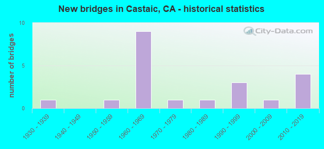
- New bridges - historical statistics
- 11930-1939
- 11950-1959
- 91960-1969
- 11970-1979
- 11980-1989
- 31990-1999
- 12000-2009
- 42010-2019

- Reconstructed bridges - Historical Statistics
- 11960-1969
- 01970-1979
- 01980-1989
- 11990-1999


- Bridge Condition - Deck
- 58.3%Good
- 16.7%Satisfactory
- 16.7%Fair
- 8.3%Poor

- Bridge Condition - Superstructure
- 8.3%Very good
- 75.0%Good
- 16.7%Fair

- Bridge Condition - Channel
- 50.0%Excellent
- 30.0%Very good
- 10.0%Good
- 10.0%Satisfactory
Find on map >> Show street view
Structure Number: 53 0065R, Location: 07-LA-005-R60.52R (Lat: 34.508161, Lng: -118.632911), Route carried "on" structure: Interstate 5, Year Built: 1951, Year Reconstructed: 1969, Status: Open, Structure Length: 1.40m (4.59ft), Average Daily Traffic: 36,657 (year 2011), Truck Traffic: 29%, Average Future Daily Traffic: 52,859 (year 2039), Design Load: HS 20, Features Intersected: PALOMAS WASH
Minimum Vertical Clearance: 30+ m (98+ ft), Kilometerpoint: 60.520, Lanes on structure: 4, Base Highway Network: Yes (, Subroute: 1), Owner: State Highway Agency, Approaching Roadway Width: 20.7m (67.9ft), Skew: 1 degrees, Material/Design: Concrete continuous, Design/Construction: Slab, Number Of Spans In Main Unit: 2, Length of Maximum Span: 6.7m (22.0ft), Curb-To-Curb Width: 20.1m (65.9ft), Out-to-Out Width: 20.7m (67.9ft)
Condition: Deck: Fair, Superstructure: Fair, Substructure: Good, Channel: Satisfactory, Operating Rating: 71.6 metric tons, Method Used To Determine Operating Rating: Load Factor (LF), Inventory Rating: 43.1 metric tons, Method Used To Determine Inventory Rating: Load Factor (LF), Structural Evaluation: Somewhat better than minimum adequacy, Deck Geometry: Equal to present minimum criteria, Waterway Adequacy: Equal to present desirable criteria, Approach Roadway Alignment: Equal to present desirable criteria, Designated Inspection Frequency: Every 24 months, Inspection Date: June 2021, Deck Structure Type: Concrete Cast-file-Place
Find on map >> Show street view
Structure Number: 53 0093, Location: 07-LA-126-R4.09 (Lat: 34.427836, Lng: -118.629469), Route carried "on" structure: State highway 126, Year Built: 1989, Year Reconstructed: 1998, Status: Open, Structure Length: 14.45m (47.41ft), Average Daily Traffic: 37,500 (year 2018), Truck Traffic: 8%, Average Future Daily Traffic: 69,766 (year 2042), Design Load: HS 20, Features Intersected: CASTAIC CREEK
Minimum Vertical Clearance: 30+ m (98+ ft), Kilometerpoint: 4.090, Lanes on structure: 4, Base Highway Network: Yes (Inventory Route: 1, Subroute: 1), Owner: State Highway Agency, Approaching Roadway Width: 26.0m (85.3ft), Skew: 2 degrees, Material/Design: Prestressed concrete continuous, Design/Construction: Box Beam or Girders - Multiple, Number Of Spans In Main Unit: 6, Length of Maximum Span: 26.2m (86.0ft), Curb-To-Curb Width: 25.0m (82.0ft), Out-to-Out Width: 26.0m (85.3ft)
Condition: Deck: Poor, Superstructure: Good, Substructure: Good, Channel: Excellent, Operating Rating: 54.1 metric tons, Method Used To Determine Operating Rating: Assigned rating based on Load Factor Design (LFD) reported in metric tons, Inventory Rating: 32.4 metric tons, Method Used To Determine Inventory Rating: Assigned rating based on Load Factor Design (LFD) reported in metric tons, Structural Evaluation: Better than present minimum criteria, Deck Geometry: Superior to present desirable criteria, Waterway Adequacy: Equal to present desirable criteria, Approach Roadway Alignment: Superior to present desirable criteria, Length Of Structure Improvement: 14.45m (47.41ft), Designated Inspection Frequency: Every 24 months, Inspection Date: October 2020, Bridge Improvement Cost: $3,757,000, Roadway Improvement Cost: $751,000, Total Project Cost: $6,311,000 ( Estimate for 2021), Deck Structure Type: Concrete Cast-file-Place
Find on map >> Show street view
Structure Number: 53 1902L, Location: 07-LA-005-R59.95L (Lat: 34.501508, Lng: -118.627231), Route carried "on" structure: Interstate 5, Year Built: 1969, Status: Open, Structure Length: 14.81m (48.59ft), Average Daily Traffic: 36,657 (year 2011), Truck Traffic: 29%, Average Future Daily Traffic: 52,859 (year 2039), Design Load: HS 20+Mod, Features Intersected: I 5 & CASTAIC ROAD
Minimum Vertical Clearance: 30+ m (98+ ft), Kilometerpoint: 59.950, Lanes on structure: 4, Lanes under structure: 6, Base Highway Network: Yes (, Subroute: 1), Owner: State Highway Agency, Approaching Roadway Width: 20.1m (65.9ft), Skew: 9 degrees, Material/Design: Prestressed concrete continuous, Design/Construction: Box Beam or Girders - Multiple, Number Of Spans In Main Unit: 4, Length of Maximum Span: 50.0m (164.0ft), Curb-To-Curb Width: 20.1m (65.9ft), Out-to-Out Width: 20.7m (67.9ft)
Condition: Deck: Good, Superstructure: Good, Substructure: Good, Operating Rating: 99.8 metric tons, Method Used To Determine Operating Rating: Load Factor (LF), Inventory Rating: 32.4 metric tons, Method Used To Determine Inventory Rating: Load Factor (LF), Structural Evaluation: Better than present minimum criteria, Deck Geometry: Equal to present minimum criteria, Underclear: Meets minimum limits, Approach Roadway Alignment: Equal to present desirable criteria, Designated Inspection Frequency: Every 24 months, Inspection Date: June 2021, Deck Structure Type: Concrete Cast-file-Place
Find on map >> Show street view
Structure Number: 53 1908L, Location: 07-LA-005-R59.49 (Lat: 34.495636, Lng: -118.623708), Route carried "on" structure: Interstate 5, Year Built: 1968, Status: Open, Structure Length: 5.79m (19.00ft), Average Daily Traffic: 37,177 (year 2011), Truck Traffic: 12%, Average Future Daily Traffic: 53,065 (year 2038), Design Load: HS 20, Features Intersected: LAKE HUGHES RD
Minimum Vertical Clearance: 30+ m (98+ ft), Kilometerpoint: 59.490, Lanes on structure: 5, Lanes under structure: 5, Base Highway Network: Yes (, Subroute: 1), Owner: State Highway Agency, Approaching Roadway Width: 24.7m (81.0ft), Material/Design: Concrete continuous, Design/Construction: Box Beam or Girders - Multiple, Number Of Spans In Main Unit: 3, Length of Maximum Span: 31.7m (104.0ft), Curb-To-Curb Width: 24.7m (81.0ft), Out-to-Out Width: 25.6m (84.0ft)
Condition: Deck: Good, Superstructure: Good, Substructure: Good, Operating Rating: 40.2 metric tons, Method Used To Determine Operating Rating: Load and Resistance Factor Rating (LRFR) rating reported by rating factor(RF) method using HL-93 loadings, Inventory Rating: 31.1 metric tons, Method Used To Determine Inventory Rating: Load and Resistance Factor Rating (LRFR) rating reported by rating factor(RF) method using HL-93 loadings, Structural Evaluation: Better than present minimum criteria, Deck Geometry: Better than present minimum criteria, Underclear: Somewhat better than minimum adequacy, Approach Roadway Alignment: Equal to present desirable criteria, Designated Inspection Frequency: Every 24 months, Inspection Date: April 2021, Deck Structure Type: Concrete Cast-file-Place
Find on map >> Show street view
Structure Number: 53 1908R, Location: 07-LA-005-R59.49 (Lat: 34.495764, Lng: -118.623467), Route carried "on" structure: Interstate 5, Year Built: 1968, Status: Open, Structure Length: 5.79m (19.00ft), Average Daily Traffic: 37,177 (year 2011), Truck Traffic: 12%, Average Future Daily Traffic: 53,065 (year 2038), Design Load: HS 20, Features Intersected: LAKE HUGHES RD
Minimum Vertical Clearance: 30+ m (98+ ft), Kilometerpoint: 59.490, Lanes on structure: 4, Lanes under structure: 5, Base Highway Network: Yes (, Subroute: 1), Owner: State Highway Agency, Approaching Roadway Width: 20.1m (65.9ft), Material/Design: Concrete continuous, Design/Construction: Box Beam or Girders - Multiple, Number Of Spans In Main Unit: 3, Length of Maximum Span: 31.7m (104.0ft), Curb-To-Curb Width: 20.1m (65.9ft), Out-to-Out Width: 20.7m (67.9ft)
Condition: Deck: Good, Superstructure: Good, Substructure: Good, Operating Rating: 40.8 metric tons, Method Used To Determine Operating Rating: Load and Resistance Factor Rating (LRFR) rating reported by rating factor(RF) method using HL-93 loadings, Inventory Rating: 31.4 metric tons, Method Used To Determine Inventory Rating: Load and Resistance Factor Rating (LRFR) rating reported by rating factor(RF) method using HL-93 loadings, Structural Evaluation: Better than present minimum criteria, Deck Geometry: Equal to present minimum criteria, Underclear: Somewhat better than minimum adequacy, Approach Roadway Alignment: Equal to present desirable criteria, Designated Inspection Frequency: Every 24 months, Inspection Date: April 2021, Deck Structure Type: Concrete Cast-file-Place
Find on map >> Show street view
Structure Number: 53 1909, Location: 07-LA-005-R59.01 (Lat: 34.489469, Lng: -118.619542), Route carried "on" structure: City street , Year Built: 1968, Status: Open, Structure Length: 7.07m (23.20ft), Average Daily Traffic: 5,647 (year 2011), Truck Traffic: 25%, Average Future Daily Traffic: 6,991 (year 2038), Design Load: HS 20, Features Intersected: ROUTE 5, Facility Carried by Structure: PARKER RD
Minimum Vertical Clearance: 30+ m (98+ ft), Kilometerpoint: 0.000, Lanes on structure: 2, Lanes under structure: 8, Owner: State Highway Agency, Approaching Roadway Width: 11.0m (36.1ft), Material/Design: Concrete continuous, Design/Construction: Box Beam or Girders - Multiple, Number Of Spans In Main Unit: 2, Length of Maximum Span: 37.2m (122.0ft), Curb or Sidewalk Widths: Left: 0.0m, Right: 1.5m (4.9ft), Curb-To-Curb Width: 11.0m (36.1ft), Out-to-Out Width: 13.3m (43.6ft)
Condition: Deck: Good, Superstructure: Good, Substructure: Good, Operating Rating: 37.6 metric tons, Method Used To Determine Operating Rating: Load and Resistance Factor Rating (LRFR) rating reported by rating factor(RF) method using HL-93 loadings, Inventory Rating: 29.2 metric tons, Method Used To Determine Inventory Rating: Load and Resistance Factor Rating (LRFR) rating reported by rating factor(RF) method using HL-93 loadings, Structural Evaluation: Better than present minimum criteria, Deck Geometry: Meets minimum limits, Underclear: Meets minimum limits, Approach Roadway Alignment: Equal to present minimum criteria, Designated Inspection Frequency: Every 24 months, Inspection Date: April 2021, Deck Structure Type: Concrete Cast-file-Place
Find on map >> Show street view
Structure Number: 53 2014L, Location: 07-LA-005-R60.20L (Lat: 34.505094, Lng: -118.627803), Route carried "on" structure: Interstate 5, Year Built: 1969, Status: Open, Structure Length: 1.11m (3.64ft), Average Daily Traffic: 36,657 (year 2011), Truck Traffic: 29%, Average Future Daily Traffic: 52,859 (year 2039), Features Intersected: VIOLIN & MARPLE CANYONS
Minimum Vertical Clearance: 30+ m (98+ ft), Kilometerpoint: 60.200, Lanes on structure: 4, Base Highway Network: Yes (, Subroute: 1), Owner: State Highway Agency, Approaching Roadway Width: 20.1m (65.9ft), Skew: 5 degrees, Material/Design: Steel, Design/Construction: Culvert, Number Of Spans In Main Unit: 1, Length of Maximum Span: 11.1m (36.4ft), Curb-To-Curb Width: 20.1m (65.9ft), Out-to-Out Width: 115.0m (377.3ft)
Condition: Channel: Good, Culverts: Good, Structural Evaluation: Better than present minimum criteria, Deck Geometry: Equal to present minimum criteria, Waterway Adequacy: Equal to present desirable criteria, Approach Roadway Alignment: Equal to present desirable criteria, Designated Inspection Frequency: Every 24 months, Inspection Date: June 2021
Find on map >> Show street view
Structure Number: 53 2353M, Location: 07-LA-005-R58.70 (Lat: 34.485769, Lng: -118.615653), Route carried "on" structure: Interstate 5, Year Built: 1968, Status: Open, Structure Length: 0.71m (2.33ft), Average Daily Traffic: 74,354 (year 2011), Truck Traffic: 12%, Average Future Daily Traffic: 106,130 (year 2038), Design Load: HS 20, Features Intersected: PARKER ROAD DRAIN
Minimum Vertical Clearance: 30+ m (98+ ft), Kilometerpoint: 58.700, Lanes on structure: 8, Base Highway Network: Yes (, Subroute: 1), Owner: State Highway Agency, Approaching Roadway Width: 40.2m (131.9ft), Skew: 34 degrees, Material/Design: Concrete continuous, Design/Construction: Culvert, Number Of Spans In Main Unit: 2, Length of Maximum Span: 3.6m (11.8ft), Curb-To-Curb Width: 40.2m (131.9ft), Out-to-Out Width: 52.0m (170.6ft)
Condition: Channel: Very good, Culverts: Good, Operating Rating: 54.1 metric tons, Method Used To Determine Operating Rating: Field evaluation and documented engineering judgment, Inventory Rating: 32.4 metric tons, Method Used To Determine Inventory Rating: Field evaluation and documented engineering judgment, Structural Evaluation: Better than present minimum criteria, Deck Geometry: Superior to present desirable criteria, Waterway Adequacy: Equal to present desirable criteria, Approach Roadway Alignment: Equal to present desirable criteria, Designated Inspection Frequency: Every 24 months, Inspection Date: April 2021
Find on map >> Show street view
Structure Number: 53 2946, Location: 07-LA-126-R4.88 (Lat: 34.434750, Lng: -118.618056), Route carried "on" structure: State highway 126, Year Built: 2016, Status: Open, Structure Length: 4.16m (13.65ft), Average Daily Traffic: 36,500 (year 2016), Average Future Daily Traffic: 48,244 (year 2037), Design Load: HS 20+Mod, Features Intersected: COMMERCE CITY DRIVE
Minimum Vertical Clearance: 30+ m (98+ ft), Kilometerpoint: 4.880, Lanes on structure: 8, Lanes under structure: 9, Base Highway Network: Yes, Owner: State Highway Agency, Approaching Roadway Width: 45.9m (150.6ft), Skew: 30 degrees, Material/Design: Prestressed concrete, Design/Construction: Box Beam or Girders - Multiple, Number Of Spans In Main Unit: 1, Length of Maximum Span: 40.6m (133.2ft), Curb-To-Curb Width: 45.9m (150.6ft), Out-to-Out Width: 47.4m (155.5ft)
Condition: Deck: Good, Superstructure: Good, Substructure: Good, Operating Rating: 54.1 metric tons, Method Used To Determine Operating Rating: Assigned rating based on Load Factor Design (LFD) reported in metric tons, Inventory Rating: 32.4 metric tons, Method Used To Determine Inventory Rating: Assigned rating based on Load Factor Design (LFD) reported in metric tons, Structural Evaluation: Better than present minimum criteria, Deck Geometry: Superior to present desirable criteria, Underclear: Meets minimum limits, Approach Roadway Alignment: Equal to present desirable criteria, Designated Inspection Frequency: Every 24 months, Inspection Date: March 2020, Deck Structure Type: Concrete Cast-file-Place
Find on map >> Show street view
Structure Number: 53 3046, Location: 07-LA-005-R56.60 (Lat: 34.455892, Lng: -118.616567), Route carried "on" structure: County highway , Year Built: 2010, Status: Open, Structure Length: 8.98m (29.46ft), Average Daily Traffic: 104,980 (year 2011), Truck Traffic: 33%, Average Future Daily Traffic: 137,922 (year 2038), Design Load: HS 20, Features Intersected: ROUTE 5, Facility Carried by Structure: HASLEY CANYON ROAD
Minimum Vertical Clearance: 30+ m (98+ ft), Kilometerpoint: 0.000, Lanes on structure: 3, Lanes under structure: 8, Owner: State Highway Agency, Approaching Roadway Width: 14.3m (46.9ft), Material/Design: Prestressed concrete continuous, Design/Construction: Box Beam or Girders - Multiple, Number Of Spans In Main Unit: 2, Length of Maximum Span: 50.1m (164.4ft), Curb or Sidewalk Widths: Left: 1.5m (4.9ft), Right: 0.0m, Curb-To-Curb Width: 17.1m (56.1ft), Out-to-Out Width: 19.4m (63.6ft)
Condition: Deck: Good, Superstructure: Good, Substructure: Good, Operating Rating: 53.8 metric tons, Method Used To Determine Operating Rating: Load Factor (LF), Inventory Rating: 32.4 metric tons, Method Used To Determine Inventory Rating: Load Factor (LF), Structural Evaluation: Better than present minimum criteria, Deck Geometry: Superior to present desirable criteria, Underclear: Equal to present minimum criteria, Approach Roadway Alignment: Equal to present desirable criteria, Designated Inspection Frequency: Every 24 months, Inspection Date: April 2021, Deck Structure Type: Concrete Cast-file-Place
Find on map >> Show street view
Structure Number: 53C0114, Location: 1.0MI N/O LAKE HUGHES RD (Lat: 34.508242, Lng: -118.632381), Route carried "on" structure: County highway , Year Built: 1930, Status: Open, Structure Length: 1.65m (5.41ft), Average Daily Traffic: 8,652 (year 2012), Truck Traffic: 2%, Average Future Daily Traffic: 9,950 (year 2040), Features Intersected: VIOLIN CRK, Facility Carried by Structure: CASTAIC RD
Minimum Vertical Clearance: 30.47m (99.97ft), Kilometerpoint: 0.000, Lanes on structure: 2, Owner: County Highway Agency, Approaching Roadway Width: 9.1m (29.9ft), Skew: 3 degrees, Material/Design: Concrete, Design/Construction: Slab, Number Of Spans In Main Unit: 2, Length of Maximum Span: 7.6m (24.9ft), Curb-To-Curb Width: 13.4m (44.0ft), Out-to-Out Width: 14.6m (47.9ft)
Condition: Deck: Satisfactory, Superstructure: Fair, Substructure: Good, Channel: Very good, Operating Rating: 39.2 metric tons, Method Used To Determine Operating Rating: Field evaluation and documented engineering judgment, Inventory Rating: 23.3 metric tons, Method Used To Determine Inventory Rating: Field evaluation and documented engineering judgment, Structural Evaluation: Somewhat better than minimum adequacy, Deck Geometry: Equal to present minimum criteria, Waterway Adequacy: Equal to present desirable criteria, Approach Roadway Alignment: Equal to present desirable criteria, Designated Inspection Frequency: Every 24 months, Inspection Date: March 2022, Deck Structure Type: Concrete Cast-file-Place, Wearing Surface/Protective System: Wearing Surface: Monolithic Concrete
Find on map >> Show street view
Structure Number: 53C0799, Location: 0.6MI E/O I-5 FWY (Lat: 34.497181, Lng: -118.612561), Route carried "on" structure: County highway W488, Year Built: 1966, Status: Open, Structure Length: 10.91m (35.79ft), Average Daily Traffic: 1,530 (year 2012), Truck Traffic: 2%, Average Future Daily Traffic: 1,683 (year 2038), Design Load: HS 20, Features Intersected: CASTAIC CRK, Facility Carried by Structure: LAKE HUGHES RD
Minimum Vertical Clearance: 30+ m (98+ ft), Kilometerpoint: 0.000, Lanes on structure: 2, Owner: County Highway Agency, Approaching Roadway Width: 8.5m (27.9ft), Skew: 1 degrees, Material/Design: Concrete, Design/Construction: Slab, Number Of Spans In Main Unit: 9, Length of Maximum Span: 12.8m (42.0ft), Curb or Sidewalk Widths: Left: 1.3m (4.3ft), Right: 0.5m (1.6ft), Curb-To-Curb Width: 8.5m (27.9ft), Out-to-Out Width: 11.0m (36.1ft)
Condition: Deck: Satisfactory, Superstructure: Good, Substructure: Good, Channel: Very good, Operating Rating: 58.0 metric tons, Method Used To Determine Operating Rating: Load Factor (LF), Inventory Rating: 34.7 metric tons, Method Used To Determine Inventory Rating: Load Factor (LF), Structural Evaluation: Better than present minimum criteria, Deck Geometry: Somewhat better than minimum adequacy, Waterway Adequacy: Equal to present desirable criteria, Approach Roadway Alignment: Equal to present desirable criteria, Designated Inspection Frequency: Every 48 months, Inspection Date: March 2018, Deck Structure Type: Concrete Cast-file-Place, Wearing Surface/Protective System: Wearing Surface: Monolithic Concrete
Find on map >> Show street view
Structure Number: 53C0851, Location: 1.0MI E/O I-5 FWY (Lat: 34.496711, Lng: -118.621872), Route carried "on" structure: County highway W488, Year Built: 1971, Status: Open, Structure Length: 1.80m (5.91ft), Average Daily Traffic: 2,958 (year 2012), Truck Traffic: 20%, Average Future Daily Traffic: 3,254 (year 2040), Design Load: HS 20, Features Intersected: VIOLIN CRK, Facility Carried by Structure: LAKE HUGHES RD
Minimum Vertical Clearance: 9.13m (29.95ft), Kilometerpoint: 0.000, Lanes on structure: 5, Owner: County Highway Agency, Approaching Roadway Width: 26.2m (86.0ft), Skew: 29 degrees, Material/Design: Concrete, Design/Construction: Tee Beam, Number Of Spans In Main Unit: 1, Length of Maximum Span: 15.5m (50.9ft), Curb or Sidewalk Widths: Left: 2.3m (7.5ft), Right: 2.3m (7.5ft), Curb-To-Curb Width: 26.2m (86.0ft), Out-to-Out Width: 32.8m (107.6ft)
Condition: Deck: Fair, Superstructure: Good, Substructure: Good, Channel: Excellent, Operating Rating: 48.6 metric tons, Method Used To Determine Operating Rating: Load Factor (LF), Inventory Rating: 29.2 metric tons, Method Used To Determine Inventory Rating: Load Factor (LF), Structural Evaluation: Better than present minimum criteria, Deck Geometry: Superior to present desirable criteria, Waterway Adequacy: Superior to present desirable criteria, Approach Roadway Alignment: Equal to present minimum criteria, Designated Inspection Frequency: Every 24 months, Inspection Date: March 2020, Deck Structure Type: Concrete Cast-file-Place, Wearing Surface/Protective System: Wearing Surface: Monolithic Concrete
Find on map >> Show street view
Structure Number: 53C2174, Location: 1.0MI N/O SR-126 HWY (Lat: 34.447144, Lng: -118.626111), Route carried "on" structure: County highway , Year Built: 1993, Status: Open, Structure Length: 5.30m (17.39ft), Average Daily Traffic: 12,976 (year 2017), Truck Traffic: 5%, Average Future Daily Traffic: 14,922 (year 2038), Design Load: HS 20, Features Intersected: HASLEY CYN CRK, Facility Carried by Structure: COMMERCE CENTER DR
Minimum Vertical Clearance: 30+ m (98+ ft), Kilometerpoint: 0.000, Lanes on structure: 6, Owner: County Highway Agency, Approaching Roadway Width: 21.3m (69.9ft), Skew: 22 degrees, Material/Design: Concrete, Design/Construction: Stringer/Multi-beam, Number Of Spans In Main Unit: 2, Length of Maximum Span: 26.5m (86.9ft), Curb or Sidewalk Widths: Left: 2.1m (6.9ft), Right: 2.1m (6.9ft), Curb-To-Curb Width: 21.3m (69.9ft), Out-to-Out Width: 30.5m (100.1ft)
Condition: Deck: Good, Superstructure: Very good, Substructure: Good, Channel: Excellent, Operating Rating: 73.9 metric tons, Method Used To Determine Operating Rating: Load Factor (LF), Inventory Rating: 33.0 metric tons, Method Used To Determine Inventory Rating: Load Factor (LF), Structural Evaluation: Better than present minimum criteria, Deck Geometry: High priority of replacement, Waterway Adequacy: Equal to present desirable criteria, Approach Roadway Alignment: Equal to present desirable criteria, Length Of Structure Improvement: 6.33m (20.77ft), Designated Inspection Frequency: Every 48 months, Inspection Date: March 2018, Deck Structure Type: Concrete Cast-file-Place
Find on map >> Show street view
Structure Number: 53C2268, Location: 0.2MI W/O THE OLD RD (Lat: 34.508044, Lng: -118.636442), Route carried "on" structure: County highway , Year Built: 1992, Status: Open, Structure Length: 2.15m (7.05ft), Average Daily Traffic: 1,607 (year 2012), Average Future Daily Traffic: 1,768 (year 2040), Features Intersected: VIOLIN CYN CHAN, Facility Carried by Structure: SIERRA OAK TRAIL
Minimum Vertical Clearance: 4.00m (13.12ft), Kilometerpoint: 0.000, Lanes on structure: 2, Owner: County Highway Agency, Approaching Roadway Width: 12.5m (41.0ft), Skew: 21 degrees, Material/Design: Concrete, Design/Construction: Culvert, Number Of Spans In Main Unit: 3, Length of Maximum Span: 7.1m (23.3ft), Curb or Sidewalk Widths: Left: 3.5m (11.5ft), Right: 3.4m (11.2ft), Curb-To-Curb Width: 12.2m (40.0ft), Out-to-Out Width: 19.7m (64.6ft)
Condition: Channel: Excellent, Culverts: Good, Operating Rating: 54.1 metric tons, Method Used To Determine Operating Rating: Field evaluation and documented engineering judgment, Inventory Rating: 32.4 metric tons, Method Used To Determine Inventory Rating: Field evaluation and documented engineering judgment, Structural Evaluation: Better than present minimum criteria, Deck Geometry: Better than present minimum criteria, Waterway Adequacy: Superior to present desirable criteria, Approach Roadway Alignment: Equal to present desirable criteria, Designated Inspection Frequency: Every 48 months, Inspection Date: April 2020, Deck Structure Type: Concrete Cast-file-Place, Wearing Surface/Protective System: Wearing Surface: Bituminous
Find on map >> Show street view
Structure Number: 53C2269, Location: 1.0MI N/O LAKE HUGHES RD (Lat: 34.508025, Lng: -118.633306), Route carried "on" structure: County highway , Year Built: 1992, Status: Open, Structure Length: 1.95m (6.40ft), Average Daily Traffic: 1,607 (year 2012), Average Future Daily Traffic: 1,768 (year 2040), Features Intersected: VIOLIN CYN CHAN, Facility Carried by Structure: THE OLD RD
Minimum Vertical Clearance: 30.47m (99.97ft), Kilometerpoint: 0.000, Lanes on structure: 2, Owner: County Highway Agency, Approaching Roadway Width: 14.4m (47.2ft), Skew: 24 degrees, Material/Design: Concrete, Design/Construction: Culvert, Number Of Spans In Main Unit: 2, Length of Maximum Span: 10.4m (34.1ft), Curb or Sidewalk Widths: Left: 2.3m (7.5ft), Right: 1.6m (5.2ft), Curb-To-Curb Width: 19.4m (63.6ft), Out-to-Out Width: 27.5m (90.2ft)
Condition: Channel: Excellent, Culverts: Good, Operating Rating: 54.1 metric tons, Method Used To Determine Operating Rating: Field evaluation and documented engineering judgment, Inventory Rating: 32.4 metric tons, Method Used To Determine Inventory Rating: Field evaluation and documented engineering judgment, Structural Evaluation: Better than present minimum criteria, Deck Geometry: Superior to present desirable criteria, Waterway Adequacy: Superior to present desirable criteria, Approach Roadway Alignment: Equal to present desirable criteria, Designated Inspection Frequency: Every 48 months, Inspection Date: April 2020, Deck Structure Type: Concrete Cast-file-Place, Wearing Surface/Protective System: Wearing Surface: Bituminous
Find on map >> Show street view
Structure Number: 53 1902L, Location: 07-LA-005-R59.95L (Lat: 34.501508, Lng: -118.627231), Route carried "under" structure: Interstate 5, Year Built: 1969, Structure Length: 0. m, Average Daily Traffic: 36,657 (year 2011), Truck Traffic: 29%, Features Intersected: I 5 & CASTAIC ROAD
Minimum Vertical Clearance: 5.05m (16.57ft), Kilometerpoint: 59.950, Lanes on structure: 4, Lanes under structure: 4, Material/Design: Prestressed concrete continuous, Design/Construction: Box Beam or Girders - Multiple, Length of Maximum Span: 50.0m (164.0ft)
Find on map >> Show street view
Structure Number: 53 1909, Location: 07-LA-005-R59.01 (Lat: 34.489469, Lng: -118.619542), Route carried "under" structure: Interstate 5, Year Built: 1968, Structure Length: 0. m, Average Daily Traffic: 74,354 (year 2011), Truck Traffic: 12%, Features Intersected: ROUTE 5, Facility Carried by Structure: PARKER RD
Minimum Vertical Clearance: 4.97m (16.31ft), Kilometerpoint: 59.010, Lanes on structure: 2, Lanes under structure: 8, Material/Design: Concrete continuous, Design/Construction: Box Beam or Girders - Multiple, Length of Maximum Span: 37.2m (122.0ft)
Find on map >> Show street view
Structure Number: 53 2946, Location: 07-LA-126-R4.88 (Lat: 34.434750, Lng: -118.618056), Route carried "under" structure: County highway , Year Built: 2016, Structure Length: 0. m, Average Daily Traffic: 10,000 (year 2018), Truck Traffic: 5%, Features Intersected: COMMERCE CITY DRIVE, Facility Carried by Structure: STATE ROUTE 126
Minimum Vertical Clearance: 5.34m (17.52ft), Kilometerpoint: 0.000, Lanes on structure: 8, Lanes under structure: 9, Material/Design: Prestressed concrete, Design/Construction: Box Beam or Girders - Multiple, Length of Maximum Span: 40.6m (133.2ft)
Find on map >> Show street view
Structure Number: 53 3046, Location: 07-LA-005-R56.60 (Lat: 34.455892, Lng: -118.616567), Route carried "under" structure: Interstate 5, Year Built: 2010, Structure Length: 0. m, Average Daily Traffic: 134,090 (year 2011), Truck Traffic: 17%, Features Intersected: ROUTE 5, Facility Carried by Structure: HASLEY CANYON ROAD
Minimum Vertical Clearance: 5.48m (17.98ft), Kilometerpoint: 56.600, Lanes on structure: 3, Lanes under structure: 8, Material/Design: Prestressed concrete continuous, Design/Construction: Box Beam or Girders - Multiple, Length of Maximum Span: 50.1m (164.4ft)
Find on map >> Show street view
Structure Number: 53C2116, Location: 0.5MI W/O I-5 FWY (Lat: 34.454231, Lng: -118.621914), Route carried "under" structure: County highway WPC2, Year Built: 2002, Structure Length: 0. m, Average Daily Traffic: 10,316 (year 2012), Truck Traffic: 2%, Features Intersected: HASLEY CYN RD, Facility Carried by Structure: HASLEY CYN RD POC
Minimum Vertical Clearance: 5.20m (17.06ft), Kilometerpoint: 0.000, Lanes under structure: 6, Material/Design: Steel, Design/Construction: Truss - Thru, Length of Maximum Span: 41.0m (134.5ft)