Bridge Statistics for Castroville, California (CA)
Condition, Traffic, Stress, Structural Evaluation, Project Costs
- National Bridge Inventory (NBI) Statistics
- 18Number of bridges
- 292ft / 89.4mTotal length
- 288,484Total average daily traffic
- 26,036Total average daily truck traffic
- National Bridge Inventory (NBI) Registered Bridges for Castroville
- No street view available for this location
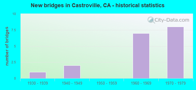
- New bridges - historical statistics
- 11930-1939
- 21940-1949
- 71960-1969
- 81970-1979
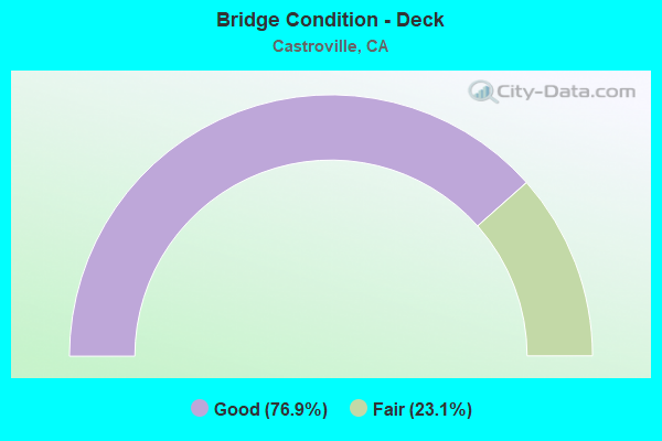
- Bridge Condition - Deck
- 76.9%Good
- 23.1%Fair
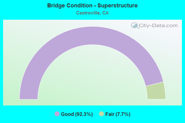
- Bridge Condition - Superstructure
- 92.3%Good
- 7.7%Fair
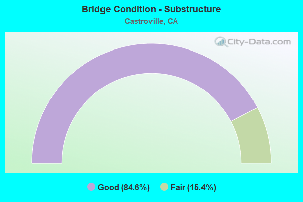
- Bridge Condition - Substructure
- 84.6%Good
- 15.4%Fair
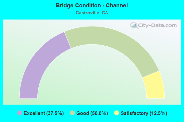
- Bridge Condition - Channel
- 37.5%Excellent
- 50.0%Good
- 12.5%Satisfactory
Find on map >> Show street view
Structure Number: 44 0023, Location: 05-MON-183-R7.30 (Lat: 36.739969, Lng: -121.738636), Route carried "on" structure: State highway 183, Year Built: 1978, Status: Open, Structure Length: 2.19m (7.19ft), Average Daily Traffic: 19,650 (year 2009), Truck Traffic: 16%, Average Future Daily Traffic: 19,706 (year 2038), Design Load: HS 20+Mod, Features Intersected: ESPINOSA SLOUGH
Minimum Vertical Clearance: 30+ m (98+ ft), Kilometerpoint: 7.300, Lanes on structure: 2, Base Highway Network: Yes (Inventory Route: 1, Subroute: 1), Owner: State Highway Agency, Approaching Roadway Width: 12.2m (40.0ft), Skew: 2 degrees, Material/Design: Concrete continuous, Design/Construction: Slab, Number Of Spans In Main Unit: 3, Length of Maximum Span: 8.5m (27.9ft), Curb-To-Curb Width: 12.2m (40.0ft), Out-to-Out Width: 13.3m (43.6ft)
Condition: Deck: Good, Superstructure: Good, Substructure: Good, Channel: Satisfactory, Operating Rating: 86.8 metric tons, Method Used To Determine Operating Rating: Load Factor (LF), Inventory Rating: 52.2 metric tons, Method Used To Determine Inventory Rating: Load Factor (LF), Structural Evaluation: Better than present minimum criteria, Deck Geometry: Somewhat better than minimum adequacy, Waterway Adequacy: Superior to present desirable criteria, Approach Roadway Alignment: Equal to present desirable criteria, Designated Inspection Frequency: Every 24 months, Inspection Date: August 2020, Deck Structure Type: Concrete Cast-file-Place, Wearing Surface/Protective System: Wearing Surface: Bituminous
Find on map >> Show street view
Structure Number: 44 0024, Location: 05-MON-183-R8.11 (Lat: 36.751469, Lng: -121.742175), Route carried "on" structure: State highway 183, Year Built: 1978, Status: Open, Structure Length: 3.05m (10.01ft), Average Daily Traffic: 19,650 (year 2009), Truck Traffic: 16%, Average Future Daily Traffic: 21,347 (year 2038), Design Load: HS 20+Mod, Features Intersected: TEMBLADERO SLOUGH
Minimum Vertical Clearance: 30+ m (98+ ft), Kilometerpoint: 8.110, Lanes on structure: 2, Base Highway Network: Yes (Inventory Route: 1, Subroute: 1), Owner: State Highway Agency, Approaching Roadway Width: 12.2m (40.0ft), Skew: 1 degrees, Material/Design: Concrete continuous, Design/Construction: Slab, Number Of Spans In Main Unit: 4, Length of Maximum Span: 8.5m (27.9ft), Curb-To-Curb Width: 12.2m (40.0ft), Out-to-Out Width: 13.3m (43.6ft)
Condition: Deck: Good, Superstructure: Good, Substructure: Good, Channel: Good, Operating Rating: 89.4 metric tons, Method Used To Determine Operating Rating: Load Factor (LF), Inventory Rating: 53.8 metric tons, Method Used To Determine Inventory Rating: Load Factor (LF), Structural Evaluation: Better than present minimum criteria, Deck Geometry: Somewhat better than minimum adequacy, Waterway Adequacy: Superior to present desirable criteria, Approach Roadway Alignment: Equal to present desirable criteria, Designated Inspection Frequency: Every 24 months, Inspection Date: August 2020, Deck Structure Type: Concrete Cast-file-Place
Find on map >> Show street view
Structure Number: 44 0033L, Location: 05-MON-156-R1.59 (Lat: 36.766917, Lng: -121.746981), Route carried "on" structure: State highway 156, Year Built: 1942, Status: Open, Structure Length: 5.97m (19.59ft), Average Daily Traffic: 16,116 (year 2008), Truck Traffic: 9%, Average Future Daily Traffic: 20,376 (year 2038), Design Load: HS 15, Features Intersected: UP RR & AMTRAK
Minimum Vertical Clearance: 30+ m (98+ ft), Kilometerpoint: 1.590, Lanes on structure: 2, Base Highway Network: Yes (Inventory Route: 1, Subroute: 1), Owner: State Highway Agency, Approaching Roadway Width: 11.6m (38.1ft), Skew: 12 degrees, Material/Design: Concrete continuous, Design/Construction: Tee Beam, Number Of Spans In Main Unit: 5, Length of Maximum Span: 18.9m (62.0ft), Curb or Sidewalk Widths: Left: 0.6m (2.0ft), Right: 0.9m (3.0ft), Curb-To-Curb Width: 7.9m (25.9ft), Out-to-Out Width: 9.7m (31.8ft)
Condition: Deck: Good, Superstructure: Good, Substructure: Good, Operating Rating: 53.8 metric tons, Method Used To Determine Operating Rating: Load Factor (LF), Inventory Rating: 32.4 metric tons, Method Used To Determine Inventory Rating: Load Factor (LF), Structural Evaluation: Better than present minimum criteria, Deck Geometry: High priority of replacement, Underclear: Somewhat better than minimum adequacy, Approach Roadway Alignment: Equal to present desirable criteria, Designated Inspection Frequency: Every 24 months, Inspection Date: August 2020, Deck Structure Type: Concrete Cast-file-Place
Find on map >> Show street view
Structure Number: 44 0033R, Location: 05-MON-156-R1.59 (Lat: 36.766708, Lng: -121.746886), Route carried "on" structure: State highway 156, Year Built: 1966, Status: Open, Structure Length: 4.69m (15.39ft), Average Daily Traffic: 16,116 (year 2008), Truck Traffic: 9%, Average Future Daily Traffic: 20,265 (year 2038), Design Load: HS 20+Mod, Features Intersected: UP RR & AMTRAK
Minimum Vertical Clearance: 30+ m (98+ ft), Kilometerpoint: 1.590, Lanes on structure: 1, Base Highway Network: Yes (Inventory Route: 1, Subroute: 1), Owner: State Highway Agency, Approaching Roadway Width: 12.2m (40.0ft), Skew: 2 degrees, Material/Design: Concrete continuous, Design/Construction: Box Beam or Girders - Multiple, Number Of Spans In Main Unit: 3, Length of Maximum Span: 21.0m (68.9ft), Curb-To-Curb Width: 11.3m (37.1ft), Out-to-Out Width: 11.9m (39.0ft)
Condition: Deck: Fair, Superstructure: Good, Substructure: Good, Operating Rating: 50.9 metric tons, Method Used To Determine Operating Rating: Load and Resistance Factor Rating (LRFR) rating reported by rating factor(RF) method using HL-93 loadings, Inventory Rating: 38.2 metric tons, Method Used To Determine Inventory Rating: Load and Resistance Factor Rating (LRFR) rating reported by rating factor(RF) method using HL-93 loadings, Structural Evaluation: Better than present minimum criteria, Deck Geometry: Meets minimum limits, Underclear: Superior to present desirable criteria, Approach Roadway Alignment: Equal to present desirable criteria, Designated Inspection Frequency: Every 24 months, Inspection Date: August 2020, Deck Structure Type: Concrete Cast-file-Place
Find on map >> Show street view
Structure Number: 44 0185, Location: 05-MON-183-8.99 (Lat: 36.761389, Lng: -121.751958), Route carried "on" structure: State highway 183, Year Built: 1966, Year Reconstructed: 1996, Status: Open, Structure Length: 4.75m (15.58ft), Average Daily Traffic: 22,400 (year 2009), Truck Traffic: 15%, Average Future Daily Traffic: 20,950 (year 2038), Design Load: HS 20+Mod, Features Intersected: STATE ROUTE 156
Minimum Vertical Clearance: 30+ m (98+ ft), Kilometerpoint: 8.990, Lanes on structure: 6, Lanes under structure: 4, Owner: State Highway Agency, Approaching Roadway Width: 27.1m (88.9ft), Material/Design: Prestressed concrete continuous, Design/Construction: Box Beam or Girders - Multiple, Number Of Spans In Main Unit: 2, Length of Maximum Span: 23.5m (77.1ft), Curb or Sidewalk Widths: Left: 1.5m (4.9ft), Right: 1.5m (4.9ft), Curb-To-Curb Width: 26.8m (87.9ft), Out-to-Out Width: 30.5m (100.1ft)
Condition: Deck: Fair, Superstructure: Good, Substructure: Good, Operating Rating: 90.1 metric tons, Method Used To Determine Operating Rating: Load Factor (LF), Inventory Rating: 32.4 metric tons, Method Used To Determine Inventory Rating: Load Factor (LF), Structural Evaluation: Better than present minimum criteria, Deck Geometry: Better than present minimum criteria, Underclear: Meets minimum limits, Approach Roadway Alignment: Equal to present desirable criteria, Designated Inspection Frequency: Every 24 months, Inspection Date: August 2020, Deck Structure Type: Concrete Cast-file-Place
Find on map >> Show street view
Structure Number: 44 0186L, Location: 05-MON-156-R0.90 (Lat: 36.759653, Lng: -121.755219), Route carried "on" structure: State highway 156, Year Built: 1966, Status: Open, Structure Length: 13.78m (45.21ft), Average Daily Traffic: 14,925 (year 2009), Truck Traffic: 8%, Average Future Daily Traffic: 17,648 (year 2038), Design Load: HS 20+Mod, Features Intersected: TEMBLADERO SLOUGH
Minimum Vertical Clearance: 30+ m (98+ ft), Kilometerpoint: 0.900, Lanes on structure: 3, Base Highway Network: Yes (Inventory Route: 1, Subroute: 1), Owner: State Highway Agency, Approaching Roadway Width: 14.9m (48.9ft), Skew: 1 degrees, Material/Design: Concrete continuous, Design/Construction: Tee Beam, Number Of Spans In Main Unit: 11, Length of Maximum Span: 12.8m (42.0ft), Curb-To-Curb Width: 14.6m (47.9ft), Out-to-Out Width: 15.2m (49.9ft)
Condition: Deck: Good, Superstructure: Good, Substructure: Good, Channel: Good, Operating Rating: 67.7 metric tons, Method Used To Determine Operating Rating: Load Factor (LF), Inventory Rating: 40.5 metric tons, Method Used To Determine Inventory Rating: Load Factor (LF), Structural Evaluation: Better than present minimum criteria, Deck Geometry: Meets minimum limits, Waterway Adequacy: Superior to present desirable criteria, Approach Roadway Alignment: Equal to present desirable criteria, Designated Inspection Frequency: Every 24 months, Inspection Date: August 2020, Deck Structure Type: Concrete Cast-file-Place
Find on map >> Show street view
Structure Number: 44 0186R, Location: 05-MON-156-R0.90 (Lat: 36.759447, Lng: -121.755131), Route carried "on" structure: State highway 156, Year Built: 1966, Status: Open, Structure Length: 13.72m (45.01ft), Average Daily Traffic: 14,925 (year 2009), Truck Traffic: 8%, Average Future Daily Traffic: 18,177 (year 2038), Design Load: HS 20+Mod, Features Intersected: TEMBLADERO SLOUGH
Minimum Vertical Clearance: 30+ m (98+ ft), Kilometerpoint: 0.900, Lanes on structure: 2, Base Highway Network: Yes (Inventory Route: 1, Subroute: 1), Owner: State Highway Agency, Approaching Roadway Width: 11.3m (37.1ft), Skew: 1 degrees, Material/Design: Concrete continuous, Design/Construction: Tee Beam, Number Of Spans In Main Unit: 11, Length of Maximum Span: 12.8m (42.0ft), Curb-To-Curb Width: 11.3m (37.1ft), Out-to-Out Width: 11.9m (39.0ft)
Condition: Deck: Good, Superstructure: Good, Substructure: Good, Channel: Good, Operating Rating: 67.7 metric tons, Method Used To Determine Operating Rating: Load Factor (LF), Inventory Rating: 40.5 metric tons, Method Used To Determine Inventory Rating: Load Factor (LF), Structural Evaluation: Better than present minimum criteria, Deck Geometry: Somewhat better than minimum adequacy, Waterway Adequacy: Superior to present desirable criteria, Approach Roadway Alignment: Equal to present desirable criteria, Designated Inspection Frequency: Every 24 months, Inspection Date: August 2020, Deck Structure Type: Concrete Cast-file-Place
Find on map >> Show street view
Structure Number: 44 0217, Location: 05-MON-001-R90.39 (Lat: 36.746144, Lng: -121.771842), Route carried "on" structure: County highway , Year Built: 1976, Status: Open, Structure Length: 11.03m (36.19ft), Average Daily Traffic: 2,400 (year 2005), Truck Traffic: 2%, Average Future Daily Traffic: 5,292 (year 2043), Design Load: HS 20+Mod, Features Intersected: SR 1, S1-MOLERA OFFRAMP, Facility Carried by Structure: MOLERA RD
Minimum Vertical Clearance: 30+ m (98+ ft), Kilometerpoint: 0.000, Lanes on structure: 2, Lanes under structure: 6, Owner: State Highway Agency, Approaching Roadway Width: 12.2m (40.0ft), Skew: 1 degrees, Material/Design: Prestressed concrete continuous, Design/Construction: Box Beam or Girders - Multiple, Number Of Spans In Main Unit: 2, Length of Maximum Span: 59.1m (193.9ft), Curb or Sidewalk Widths: Left: 0.0m, Right: 1.5m (4.9ft), Curb-To-Curb Width: 12.2m (40.0ft), Out-to-Out Width: 14.3m (46.9ft)
Condition: Deck: Good, Superstructure: Good, Substructure: Good, Operating Rating: 50.2 metric tons, Method Used To Determine Operating Rating: Load and Resistance Factor Rating (LRFR) rating reported by rating factor(RF) method using HL-93 loadings, Inventory Rating: 38.6 metric tons, Method Used To Determine Inventory Rating: Load and Resistance Factor Rating (LRFR) rating reported by rating factor(RF) method using HL-93 loadings, Structural Evaluation: Better than present minimum criteria, Deck Geometry: Equal to present minimum criteria, Underclear: Better than present minimum criteria, Approach Roadway Alignment: Equal to present desirable criteria, Designated Inspection Frequency: Every 24 months, Inspection Date: August 2021, Deck Structure Type: Concrete Cast-file-Place
Find on map >> Show street view
Structure Number: 44 0218R, Location: 05-MON-001-R90.93 (Lat: 36.752278, Lng: -121.765897), Route carried "on" structure: State highway 1, Year Built: 1976, Status: Open, Structure Length: 15.24m (50.00ft), Average Daily Traffic: 23,500 (year 2009), Truck Traffic: 8%, Average Future Daily Traffic: 26,387 (year 2043), Design Load: HS 20+Mod, Features Intersected: W156-S1 CONNECTOR RAMP
Minimum Vertical Clearance: 30+ m (98+ ft), Kilometerpoint: 90.930, Lanes on structure: 2, Lanes under structure: 2, Base Highway Network: Yes (, Subroute: 1), Owner: State Highway Agency, Approaching Roadway Width: 11.9m (39.0ft), Material/Design: Prestressed concrete continuous, Design/Construction: Box Beam or Girders - Multiple, Number Of Spans In Main Unit: 3, Length of Maximum Span: 57.9m (190.0ft), Curb-To-Curb Width: 11.9m (39.0ft), Out-to-Out Width: 12.5m (41.0ft)
Condition: Deck: Good, Superstructure: Good, Substructure: Fair, Operating Rating: 79.4 metric tons, Method Used To Determine Operating Rating: Load Factor (LF), Inventory Rating: 47.6 metric tons, Method Used To Determine Inventory Rating: Load Factor (LF), Structural Evaluation: Somewhat better than minimum adequacy, Deck Geometry: Better than present minimum criteria, Underclear: Equal to present minimum criteria, Approach Roadway Alignment: Equal to present desirable criteria, Designated Inspection Frequency: Every 24 months, Inspection Date: August 2021, Deck Structure Type: Concrete Cast-file-Place
Find on map >> Show street view
Structure Number: 44 0219, Location: 05-MON-001-T91.99 (Lat: 36.767569, Lng: -121.765019), Route carried "on" structure: State highway 1, Year Built: 1976, Status: Open, Structure Length: 8.50m (27.89ft), Average Daily Traffic: 23,350 (year 2009), Truck Traffic: 8%, Average Future Daily Traffic: 32,636 (year 2043), Design Load: HS 20+Mod, Features Intersected: TEMBLADERO SLOUGH
Minimum Vertical Clearance: 30+ m (98+ ft), Kilometerpoint: 91.990, Lanes on structure: 2, Base Highway Network: Yes (, Subroute: 1), Owner: State Highway Agency, Approaching Roadway Width: 16.2m (53.1ft), Skew: 1 degrees, Material/Design: Concrete continuous, Design/Construction: Tee Beam, Number Of Spans In Main Unit: 7, Length of Maximum Span: 13.1m (43.0ft), Curb-To-Curb Width: 16.3m (53.5ft), Out-to-Out Width: 16.9m (55.4ft)
Condition: Deck: Good, Superstructure: Good, Substructure: Good, Channel: Good, Operating Rating: 45.0 metric tons, Method Used To Determine Operating Rating: Load and Resistance Factor Rating (LRFR) rating reported by rating factor(RF) method using HL-93 loadings, Inventory Rating: 35.0 metric tons, Method Used To Determine Inventory Rating: Load and Resistance Factor Rating (LRFR) rating reported by rating factor(RF) method using HL-93 loadings, Structural Evaluation: Better than present minimum criteria, Deck Geometry: Superior to present desirable criteria, Waterway Adequacy: Equal to present minimum criteria, Approach Roadway Alignment: Better than present minimum criteria, Designated Inspection Frequency: Every 48 months, Inspection Date: August 2021, Deck Structure Type: Concrete Cast-file-Place
Find on map >> Show street view
Structure Number: 44C0037, Location: 0.1 MI S SR 183 (Lat: 36.765028, Lng: -121.759475), Route carried "on" structure: County highway , Year Built: 1930, Status: Open, Structure Length: 1.22m (4.00ft), Average Daily Traffic: 230 (year 2013), Truck Traffic: 33%, Average Future Daily Traffic: 467 (year 2038), Features Intersected: TEMBLADERO SLOUGH, Facility Carried by Structure: PRESTON ROAD
Minimum Vertical Clearance: 30+ m (98+ ft), Kilometerpoint: 0.000, Lanes on structure: 2, Owner: County Highway Agency, Approaching Roadway Width: 7.9m (25.9ft), Material/Design: Concrete, Design/Construction: Tee Beam, Number Of Spans In Main Unit: 1, Length of Maximum Span: 11.9m (39.0ft), Curb or Sidewalk Widths: Left: 0.5m (1.6ft), Right: 0.5m (1.6ft), Curb-To-Curb Width: 7.3m (24.0ft), Out-to-Out Width: 8.3m (27.2ft)
Condition: Deck: Good, Superstructure: Good, Substructure: Fair, Channel: Excellent, Operating Rating: 36.3 metric tons, Method Used To Determine Operating Rating: Load and Resistance Factor Rating (LRFR) rating reported by rating factor(RF) method using HL-93 loadings, Inventory Rating: 27.9 metric tons, Method Used To Determine Inventory Rating: Load and Resistance Factor Rating (LRFR) rating reported by rating factor(RF) method using HL-93 loadings, Structural Evaluation: Somewhat better than minimum adequacy, Deck Geometry: Somewhat better than minimum adequacy, Waterway Adequacy: Equal to present minimum criteria, Approach Roadway Alignment: Equal to present desirable criteria, Designated Inspection Frequency: Every 24 months, Inspection Date: September 2021, Deck Structure Type: Concrete Cast-file-Place, Wearing Surface/Protective System: Wearing Surface: Bituminous
Find on map >> Show street view
Structure Number: 44C0048, Location: 0.2 MI S SR 183 (Lat: 36.759478, Lng: -121.754458), Route carried "on" structure: County highway , Year Built: 1966, Status: Open, Structure Length: 2.35m (7.71ft), Average Daily Traffic: 200 (year 2013), Truck Traffic: 7%, Average Future Daily Traffic: 407 (year 2038), Design Load: HS 20, Features Intersected: TEMBLADERO SLOUGH, Facility Carried by Structure: HARO ST
Minimum Vertical Clearance: 30+ m (98+ ft), Kilometerpoint: 0.000, Lanes on structure: 2, Owner: County Highway Agency, Approaching Roadway Width: 8.5m (27.9ft), Skew: 1 degrees, Material/Design: Concrete continuous, Design/Construction: Slab, Number Of Spans In Main Unit: 3, Length of Maximum Span: 9.1m (29.9ft), Curb-To-Curb Width: 8.5m (27.9ft), Out-to-Out Width: 9.2m (30.2ft)
Condition: Deck: Good, Superstructure: Good, Substructure: Good, Channel: Excellent, Operating Rating: 57.3 metric tons, Method Used To Determine Operating Rating: Load Factor (LF), Inventory Rating: 34.3 metric tons, Method Used To Determine Inventory Rating: Load Factor (LF), Structural Evaluation: Better than present minimum criteria, Deck Geometry: Equal to present minimum criteria, Waterway Adequacy: Better than present minimum criteria, Approach Roadway Alignment: Equal to present desirable criteria, Designated Inspection Frequency: Every 48 months, Inspection Date: September 2021, Deck Structure Type: Concrete Cast-file-Place
Find on map >> Show street view
Structure Number: 44C0054, Location: 0.15 MI S SR 183 (Lat: 36.760281, Lng: -121.754858), Route carried "on" structure: County highway , Year Built: 1942, Status: Open, Structure Length: 2.90m (9.51ft), Average Daily Traffic: 200 (year 2013), Truck Traffic: 40%, Average Future Daily Traffic: 407 (year 2038), Features Intersected: TEMBLADERO SLOUGH, Facility Carried by Structure: SALINAS ST
Minimum Vertical Clearance: 30+ m (98+ ft), Kilometerpoint: 0.000, Lanes on structure: 2, Owner: County Highway Agency, Approaching Roadway Width: 7.9m (25.9ft), Skew: 1 degrees, Material/Design: Concrete continuous, Design/Construction: Slab, Number Of Spans In Main Unit: 5, Length of Maximum Span: 8.8m (28.9ft), Curb or Sidewalk Widths: Left: 1.3m (4.3ft), Right: 1.3m (4.3ft), Curb-To-Curb Width: 7.9m (25.9ft), Out-to-Out Width: 11.1m (36.4ft)
Condition: Deck: Fair, Superstructure: Fair, Substructure: Good, Channel: Excellent, Operating Rating: 22.0 metric tons, Method Used To Determine Operating Rating: Load and Resistance Factor Rating (LRFR) rating reported by rating factor(RF) method using HL-93 loadings, Inventory Rating: 16.8 metric tons, Method Used To Determine Inventory Rating: Load and Resistance Factor Rating (LRFR) rating reported by rating factor(RF) method using HL-93 loadings, Structural Evaluation: Somewhat better than minimum adequacy, Deck Geometry: Somewhat better than minimum adequacy, Waterway Adequacy: Better than present minimum criteria, Approach Roadway Alignment: Equal to present desirable criteria, Designated Inspection Frequency: Every 24 months, Inspection Date: September 2021, Deck Structure Type: Concrete Cast-file-Place
Find on map >> Show street view
Structure Number: 44 0185, Location: 05-MON-183-8.99 (Lat: 36.761389, Lng: -121.751958), Route carried "under" structure: State highway 156, Year Built: 1966, Structure Length: 0. m, Average Daily Traffic: 29,850 (year 2009), Features Intersected: STATE ROUTE 156, Facility Carried by Structure: STATE ROUTE 183
Minimum Vertical Clearance: 5.25m (17.22ft), Kilometerpoint: 1.110, Lanes on structure: 6, Lanes under structure: 4, Material/Design: Prestressed concrete continuous, Design/Construction: Box Beam or Girders - Multiple, Length of Maximum Span: 23.5m (77.1ft)
Find on map >> Show street view
Structure Number: 44 0196, Location: 05-MON-156-R1.35 (Lat: 36.764069, Lng: -121.750111), Route carried "under" structure: State highway 156, Year Built: 1966, Structure Length: 0. m, Average Daily Traffic: 29,172 (year 2008), Truck Traffic: 9%, Features Intersected: STATE ROUTE 156, Facility Carried by Structure: PEDESTRIAN WALKWAY
Minimum Vertical Clearance: 5.23m (17.16ft), Kilometerpoint: 1.350, Lanes under structure: 5, Material/Design: Concrete continuous, Design/Construction: Box Beam or Girders - Multiple, Length of Maximum Span: 22.3m (73.2ft)
Find on map >> Show street view
Structure Number: 44 0217, Location: 05-MON-001-R90.39 (Lat: 36.746144, Lng: -121.771842), Route carried "under" structure: State highway 1, Year Built: 1976, Structure Length: 0. m, Average Daily Traffic: 47,000 (year 2009), Truck Traffic: 8%, Features Intersected: SR 1, S1-MOLERA OFFRAMP, Facility Carried by Structure: MOLERA RD
Minimum Vertical Clearance: 5.48m (17.98ft), Kilometerpoint: 90.390, Lanes on structure: 2, Lanes under structure: 5, Material/Design: Prestressed concrete continuous, Design/Construction: Box Beam or Girders - Multiple, Length of Maximum Span: 59.1m (193.9ft)
Find on map >> Show street view
Structure Number: 44 0217, Location: 05-MON-001-R90.39 (Lat: 36.746144, Lng: -121.771842), Route carried "under" structure: Ramp State highway 1, Year Built: 1976, Structure Length: 0. m, Average Daily Traffic: 600 (year 2013), Truck Traffic: 2%, Features Intersected: SR 1, S1-MOLERA OFFRAMP, Facility Carried by Structure: MOLERA RD
Minimum Vertical Clearance: 5.48m (17.98ft), Kilometerpoint: 90.390, Lanes on structure: 2, Lanes under structure: 1, Material/Design: Prestressed concrete continuous, Design/Construction: Box Beam or Girders - Multiple, Length of Maximum Span: 59.1m (193.9ft)
Find on map >> Show street view
Structure Number: 44 0218R, Location: 05-MON-001-R90.93 (Lat: 36.752278, Lng: -121.765897), Route carried "under" structure: Ramp State highway 156, Year Built: 1976, Structure Length: 0. m, Average Daily Traffic: 8,200 (year 2013), Truck Traffic: 9%, Features Intersected: W156-S1 CONNECTOR RAMP, Facility Carried by Structure: STATE ROUTE 1 NB
Minimum Vertical Clearance: 5.76m (18.90ft), Kilometerpoint: 0.170, Lanes on structure: 2, Lanes under structure: 2, Material/Design: Prestressed concrete continuous, Design/Construction: Box Beam or Girders - Multiple, Length of Maximum Span: 57.9m (190.0ft)