Bridge Statistics for Charlottesville, Virginia (VA)
Condition, Traffic, Stress, Structural Evaluation, Project Costs
- National Bridge Inventory (NBI) Statistics
- 64Number of bridges
- 627ft / 191mTotal length
- $2,850,000Total costs
- 990,556Total average daily traffic
- 37,387Total average daily truck traffic
- National Bridge Inventory (NBI) Registered Bridges for Charlottesville
- No street view available for this location
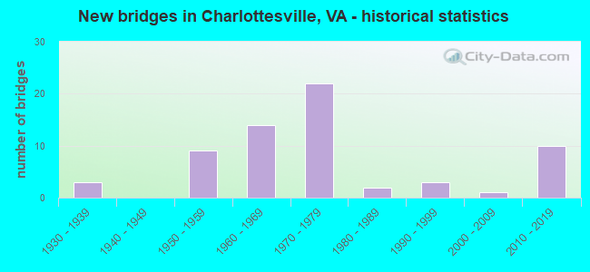
- New bridges - historical statistics
- 31930-1939
- 91950-1959
- 141960-1969
- 221970-1979
- 21980-1989
- 31990-1999
- 12000-2009
- 102010-2019

- Reconstructed bridges - Historical Statistics
- 11950-1959
- 01960-1969
- 01970-1979
- 01980-1989
- 01990-1999
- 02000-2009
- 12010-2019
- 12020-2022


- Bridge Condition - Deck
- 6.1%Very good
- 45.5%Good
- 24.2%Satisfactory
- 12.1%Fair
- 12.1%Poor

- Bridge Condition - Superstructure
- 3.0%Excellent
- 12.1%Very good
- 24.2%Good
- 36.4%Satisfactory
- 12.1%Fair
- 12.1%Poor

- Bridge Condition - Substructure
- 12.1%Very good
- 27.3%Good
- 39.4%Satisfactory
- 21.2%Fair

- Bridge Condition - Channel
- 26.1%Good
- 26.1%Satisfactory
- 47.8%Fair

- Bridge Condition - Culverts
- 28.6%Good
- 64.3%Satisfactory
- 7.1%Fair
Find on map >> Show street view
Structure Number: 42, Location: 6.03 FR 708 / 1.29 TO 53 (Lat: 37.991314, Lng: -78.496336), Route carried "on" structure: State highway 20, Year Built: 1932, Year Reconstructed: 1950, Status: Open, Structure Length: 0.88m (2.89ft), Average Daily Traffic: 5,382 (year 2020), Truck Traffic: 3%, Average Future Daily Traffic: 5,920 (year 2040), Design Load: H 15, Features Intersected: STREAM, Facility Carried by Structure: SCOTTSVILLE ROAD
Minimum Vertical Clearance: 30+ m (98+ ft), Kilometerpoint: 57.144, Lanes on structure: 2, Owner: State Highway Agency, Approaching Roadway Width: 6.4m (21.0ft), Skew: 4 degrees, Material/Design: Concrete, Design/Construction: Slab, Number Of Spans In Main Unit: 1, Length of Maximum Span: 8.8m (28.9ft), Curb or Sidewalk Widths: Left: 0.2m (0.7ft), Right: 0.2m (0.7ft), Curb-To-Curb Width: 6.9m (22.6ft), Out-to-Out Width: 7.7m (25.3ft)
Condition: Deck: Fair, Superstructure: Fair, Substructure: Satisfactory, Channel: Satisfactory, Operating Rating: 44.5 metric tons, Method Used To Determine Operating Rating: Field evaluation and documented engineering judgment, Inventory Rating: 32.7 metric tons, Method Used To Determine Inventory Rating: Field evaluation and documented engineering judgment, Structural Evaluation: Somewhat better than minimum adequacy, Deck Geometry: High priority of replacement, Waterway Adequacy: Somewhat better than minimum adequacy, Approach Roadway Alignment: Equal to present minimum criteria, Length Of Structure Improvement: 1.07m (3.51ft), Designated Inspection Frequency: Every 24 months, Inspection Date: May 2021, Bridge Improvement Cost: $115,000, Roadway Improvement Cost: $20,000, Total Project Cost: $150,000, Deck Structure Type: Concrete Cast-file-Place, Wearing Surface/Protective System: Wearing Surface: Bituminous
Find on map >> Show street view
Structure Number: 442, Location: 0.25 FR 53/0.53 SCL CHARL (Lat: 38.007136, Lng: -78.478925), Route carried "on" structure: State highway 20, Year Built: 1970, Status: Open, Structure Length: 1.04m (3.41ft), Average Daily Traffic: 17,830 (year 2020), Truck Traffic: 3%, Average Future Daily Traffic: 24,962 (year 2040), Design Load: HS 20, Features Intersected: BRANCH MOORES CREEK, Facility Carried by Structure: SCOTTSVILLE ROAD
Minimum Vertical Clearance: 30+ m (98+ ft), Kilometerpoint: 59.636, Lanes on structure: 4, Owner: State Highway Agency, Approaching Roadway Width: 18.9m (62.0ft), Skew: 4 degrees, Material/Design: Concrete, Design/Construction: Culvert, Number Of Spans In Main Unit: 4, Length of Maximum Span: 1.8m (5.9ft)
Condition: Channel: Fair, Culverts: Satisfactory, Operating Rating: 89.8 metric tons, Method Used To Determine Operating Rating: Load Factor (LF), Inventory Rating: 89.8 metric tons, Method Used To Determine Inventory Rating: Load Factor (LF), Structural Evaluation: Equal to present minimum criteria, Waterway Adequacy: Somewhat better than minimum adequacy, Approach Roadway Alignment: Equal to present desirable criteria, Designated Inspection Frequency: Every 24 months, Inspection Date: May 2020
Find on map >> Show street view
Structure Number: 443, Location: 0.72 FR 53/0.06 SCL CHARL (Lat: 38.013247, Lng: -78.475278), Route carried "on" structure: State highway 20, Year Built: 1970, Status: Open, Structure Length: 4.30m (14.11ft), Average Daily Traffic: 7,327 (year 2020), Truck Traffic: 2%, Average Future Daily Traffic: 10,258 (year 2040), Design Load: HS 20+Mod, Features Intersected: MOORES CREEK, Facility Carried by Structure: MONTICELLO AVENUE
Minimum Vertical Clearance: 30+ m (98+ ft), Kilometerpoint: 60.434, Lanes on structure: 2, Owner: State Highway Agency, Approaching Roadway Width: 9.4m (30.8ft), Skew: 1 degrees, Material/Design: Prestressed concrete, Design/Construction: Stringer/Multi-beam, Number Of Spans In Main Unit: 3, Length of Maximum Span: 14.3m (46.9ft), Curb or Sidewalk Widths: Left: 0.5m (1.6ft), Right: 1.5m (4.9ft), Curb-To-Curb Width: 9.6m (31.5ft), Out-to-Out Width: 12.4m (40.7ft)
Condition: Deck: Good, Superstructure: Satisfactory, Substructure: Good, Channel: Good, Operating Rating: 83.5 metric tons, Method Used To Determine Operating Rating: Load and Resistance Factor (LRFR), Inventory Rating: 64.4 metric tons, Method Used To Determine Inventory Rating: Load and Resistance Factor (LRFR), Structural Evaluation: Equal to present minimum criteria, Deck Geometry: Meets minimum limits, Waterway Adequacy: Equal to present minimum criteria, Approach Roadway Alignment: Equal to present minimum criteria, Designated Inspection Frequency: Every 24 months, Inspection Date: May 2021, Deck Structure Type: Concrete Cast-file-Place, Wearing Surface/Protective System: Wearing Surface: Epoxy Overlay
Find on map >> Show street view
Structure Number: 444, Location: 0.72 FR 53/0.06 SCL CHARL (Lat: 38.013369, Lng: -78.475450), Route carried "on" structure: State highway 20, Year Built: 1970, Status: Open, Structure Length: 4.07m (13.35ft), Average Daily Traffic: 7,327 (year 2020), Truck Traffic: 2%, Average Future Daily Traffic: 10,258 (year 2040), Design Load: HS 20+Mod, Features Intersected: MOORES CREEK, Facility Carried by Structure: MONTICELLO AVENUE
Minimum Vertical Clearance: 30+ m (98+ ft), Kilometerpoint: 60.434, Lanes on structure: 2, Owner: State Highway Agency, Approaching Roadway Width: 9.4m (30.8ft), Skew: 1 degrees, Material/Design: Prestressed concrete, Design/Construction: Stringer/Multi-beam, Number Of Spans In Main Unit: 3, Length of Maximum Span: 13.6m (44.6ft), Curb or Sidewalk Widths: Left: 1.5m (4.9ft), Right: 0.5m (1.6ft), Curb-To-Curb Width: 9.6m (31.5ft), Out-to-Out Width: 12.4m (40.7ft)
Condition: Deck: Fair, Superstructure: Satisfactory, Substructure: Good, Channel: Good, Operating Rating: 89.8 metric tons, Method Used To Determine Operating Rating: Load and Resistance Factor (LRFR), Inventory Rating: 71.7 metric tons, Method Used To Determine Inventory Rating: Load and Resistance Factor (LRFR), Structural Evaluation: Equal to present minimum criteria, Deck Geometry: Meets minimum limits, Waterway Adequacy: Equal to present minimum criteria, Approach Roadway Alignment: Equal to present minimum criteria, Designated Inspection Frequency: Every 24 months, Inspection Date: May 2021, Deck Structure Type: Concrete Cast-file-Place, Wearing Surface/Protective System: Wearing Surface: Epoxy Overlay
Find on map >> Show street view
Structure Number: 475, Location: 1.36FR250/0.11WCL CHVILLE (Lat: 38.056975, Lng: -78.504131), Route carried "on" structure: Bypass US 29, Year Built: 1977, Status: Open, Structure Length: 5.64m (18.50ft), Average Daily Traffic: 46,843 (year 2020), Truck Traffic: 3%, Average Future Daily Traffic: 65,580 (year 2040), Design Load: HS 20+Mod, Features Intersected: RTE 654_(BARRACKS ROAD), Facility Carried by Structure: MONACAN TRAIL ROAD
Minimum Vertical Clearance: 30+ m (98+ ft), Kilometerpoint: 152.147, Lanes on structure: 4, Lanes under structure: 4, Base Highway Network: Yes, Owner: State Highway Agency, Approaching Roadway Width: 25.6m (84.0ft), Skew: 23 degrees, Material/Design: Steel, Design/Construction: Stringer/Multi-beam, Number Of Spans In Main Unit: 3, Length of Maximum Span: 32.0m (105.0ft), Curb or Sidewalk Widths: Left: 0.3m (1.0ft), Right: 0.3m (1.0ft), Curb-To-Curb Width: 20.7m (67.9ft), Out-to-Out Width: 26.8m (87.9ft)
Condition: Deck: Satisfactory, Superstructure: Good, Substructure: Fair, Operating Rating: 68.9 metric tons, Method Used To Determine Operating Rating: Load and Resistance Factor (LRFR), Inventory Rating: 53.5 metric tons, Method Used To Determine Inventory Rating: Load and Resistance Factor (LRFR), Structural Evaluation: Somewhat better than minimum adequacy, Deck Geometry: Equal to present minimum criteria, Underclear: Meets minimum limits, Approach Roadway Alignment: Equal to present desirable criteria, Length Of Structure Improvement: 5.64m (18.50ft), Designated Inspection Frequency: Every 24 months, Inspection Date: August 2021, Bridge Improvement Cost: $50,000, Roadway Improvement Cost: $5,000, Total Project Cost: $60,000, Deck Structure Type: Concrete Cast-file-Place
Find on map >> Show street view
Structure Number: 513, Location: 0.05 FR 20 / 2.60 TO 250E (Lat: 38.011006, Lng: -78.476375), Route carried "on" structure: Interstate 64, Year Built: 1969, Status: Open, Structure Length: 0.61m (2.00ft), Average Daily Traffic: 37,559 (year 2020), Truck Traffic: 11%, Average Future Daily Traffic: 52,583 (year 2040), Design Load: HS 20+Mod, Features Intersected: BRANCH MOORES CREEK
Minimum Vertical Clearance: 30+ m (98+ ft), Kilometerpoint: 196.185, Lanes on structure: 4, Base Highway Network: Yes, Owner: State Highway Agency, Approaching Roadway Width: 14.6m (47.9ft), Skew: 4 degrees, Material/Design: Concrete, Design/Construction: Culvert, Number Of Spans In Main Unit: 2, Length of Maximum Span: 3.0m (9.8ft)
Condition: Channel: Good, Culverts: Satisfactory, Operating Rating: 89.8 metric tons, Method Used To Determine Operating Rating: Load Factor (LF), Inventory Rating: 89.8 metric tons, Method Used To Determine Inventory Rating: Load Factor (LF), Structural Evaluation: Equal to present minimum criteria, Waterway Adequacy: Superior to present desirable criteria, Approach Roadway Alignment: Equal to present desirable criteria, Designated Inspection Frequency: Every 24 months, Inspection Date: April 2020
Find on map >> Show street view
Structure Number: 514, Location: 0.06 FR 20N / 0.08 TO 64W (Lat: 38.012683, Lng: -78.475028), Route carried "on" structure: Ramp Interstate 64, Year Built: 1969, Status: Open, Structure Length: 0.61m (2.00ft), Average Daily Traffic: 3,727 (year 2020), Average Future Daily Traffic: 4,100 (year 2040), Design Load: HS 20, Features Intersected: BRANCH MOORES CREEK
Minimum Vertical Clearance: 30+ m (98+ ft), Kilometerpoint: 33.210, Lanes on structure: 3, Base Highway Network: Yes, Owner: State Highway Agency, Approaching Roadway Width: 7.3m (24.0ft), Skew: 4 degrees, Material/Design: Concrete, Design/Construction: Culvert, Number Of Spans In Main Unit: 2, Length of Maximum Span: 3.0m (9.8ft)
Condition: Channel: Fair, Culverts: Satisfactory, Operating Rating: 89.8 metric tons, Method Used To Determine Operating Rating: Load Factor (LF), Inventory Rating: 89.8 metric tons, Method Used To Determine Inventory Rating: Load Factor (LF), Structural Evaluation: Equal to present minimum criteria, Waterway Adequacy: Equal to present minimum criteria, Approach Roadway Alignment: Equal to present minimum criteria, Designated Inspection Frequency: Every 24 months, Inspection Date: April 2020
Find on map >> Show street view
Structure Number: 522, Location: 0.20 FR 631 / 1.62 TO 20 (Lat: 38.007750, Lng: -78.505606), Route carried "on" structure: Interstate 64, Year Built: 1969, Status: Open, Structure Length: 8.21m (26.94ft), Average Daily Traffic: 20,197 (year 2020), Truck Traffic: 11%, Average Future Daily Traffic: 28,276 (year 2040), Design Load: HS 20+Mod, Features Intersected: BISCUIT RUN & ACCESS RD
Minimum Vertical Clearance: 30+ m (98+ ft), Kilometerpoint: 193.482, Lanes on structure: 3, Base Highway Network: Yes, Owner: State Highway Agency, Approaching Roadway Width: 11.3m (37.1ft), Skew: 2 degrees, Material/Design: Prestressed concrete, Design/Construction: Stringer/Multi-beam, Number Of Spans In Main Unit: 4, Length of Maximum Span: 20.3m (66.6ft), Curb or Sidewalk Widths: Left: 0.2m (0.7ft), Right: 0.2m (0.7ft), Curb-To-Curb Width: 14.2m (46.6ft), Out-to-Out Width: 15.2m (49.9ft)
Condition: Deck: Satisfactory, Superstructure: Satisfactory, Substructure: Satisfactory, Channel: Satisfactory, Operating Rating: 89.8 metric tons, Method Used To Determine Operating Rating: Load and Resistance Factor (LRFR), Inventory Rating: 59.9 metric tons, Method Used To Determine Inventory Rating: Load and Resistance Factor (LRFR), Structural Evaluation: Equal to present minimum criteria, Deck Geometry: Meets minimum limits, Waterway Adequacy: Superior to present desirable criteria, Approach Roadway Alignment: Equal to present desirable criteria, Designated Inspection Frequency: Every 24 months, Inspection Date: October 2021, Deck Structure Type: Concrete Cast-file-Place, Wearing Surface/Protective System: Wearing Surface: Epoxy Overlay
Find on map >> Show street view
Structure Number: 524, Location: 0.20 FR 631 / 1.62 TO 20 (Lat: 38.007978, Lng: -78.505394), Route carried "on" structure: Interstate 64, Year Built: 1969, Status: Open, Structure Length: 7.70m (25.26ft), Average Daily Traffic: 20,366 (year 2020), Truck Traffic: 11%, Average Future Daily Traffic: 28,512 (year 2040), Design Load: HS 20+Mod, Features Intersected: BISCUIT RUN & ACCESS RD
Minimum Vertical Clearance: 30+ m (98+ ft), Kilometerpoint: 193.402, Lanes on structure: 3, Base Highway Network: Yes, Owner: State Highway Agency, Approaching Roadway Width: 11.3m (37.1ft), Skew: 2 degrees, Material/Design: Prestressed concrete, Design/Construction: Stringer/Multi-beam, Number Of Spans In Main Unit: 4, Length of Maximum Span: 19.1m (62.7ft), Curb or Sidewalk Widths: Left: 0.2m (0.7ft), Right: 0.2m (0.7ft), Curb-To-Curb Width: 14.2m (46.6ft), Out-to-Out Width: 15.2m (49.9ft)
Condition: Deck: Satisfactory, Superstructure: Satisfactory, Substructure: Satisfactory, Channel: Satisfactory, Operating Rating: 89.8 metric tons, Method Used To Determine Operating Rating: Load and Resistance Factor (LRFR), Inventory Rating: 59.0 metric tons, Method Used To Determine Inventory Rating: Load and Resistance Factor (LRFR), Structural Evaluation: Equal to present minimum criteria, Deck Geometry: Meets minimum limits, Waterway Adequacy: Superior to present desirable criteria, Approach Roadway Alignment: Equal to present desirable criteria, Designated Inspection Frequency: Every 24 months, Inspection Date: October 2021, Deck Structure Type: Concrete Cast-file-Place, Wearing Surface/Protective System: Wearing Surface: Epoxy Overlay
Find on map >> Show street view
Structure Number: 528, Location: 1.82 FR 631 & 2.64 TO 250 (Lat: 38.011003, Lng: -78.477281), Route carried "on" structure: Interstate 64, Year Built: 1969, Status: Open, Structure Length: 9.88m (32.41ft), Average Daily Traffic: 19,269 (year 2020), Truck Traffic: 10%, Average Future Daily Traffic: 26,977 (year 2040), Design Load: HS 20+Mod, Features Intersected: RTE 20 (SCOTTSVILLE RD)
Minimum Vertical Clearance: 30+ m (98+ ft), Kilometerpoint: 195.960, Lanes on structure: 3, Lanes under structure: 5, Base Highway Network: Yes, Owner: State Highway Agency, Approaching Roadway Width: 11.3m (37.1ft), Skew: 4 degrees, Material/Design: Steel, Design/Construction: Stringer/Multi-beam, Number Of Spans In Main Unit: 4, Length of Maximum Span: 31.1m (102.0ft), Curb or Sidewalk Widths: Left: 0.2m (0.7ft), Right: 0.2m (0.7ft), Curb-To-Curb Width: 13.5m (44.3ft), Out-to-Out Width: 14.6m (47.9ft)
Condition: Deck: Good, Superstructure: Satisfactory, Substructure: Satisfactory, Operating Rating: 72.6 metric tons, Method Used To Determine Operating Rating: Load and Resistance Factor (LRFR), Inventory Rating: 56.2 metric tons, Method Used To Determine Inventory Rating: Load and Resistance Factor (LRFR), Structural Evaluation: Equal to present minimum criteria, Deck Geometry: Meets minimum limits, Underclear: Equal to present minimum criteria, Approach Roadway Alignment: Equal to present desirable criteria, Designated Inspection Frequency: Every 24 months, Inspection Date: August 2021, Deck Structure Type: Concrete Cast-file-Place, Wearing Surface/Protective System: Wearing Surface: Latex Concrete
Find on map >> Show street view
Structure Number: 564, Location: 0.82 FR 29 / 1/02 TO 631 (Lat: 38.013119, Lng: -78.526664), Route carried "on" structure: Interstate 64, Year Built: 1970, Status: Open, Structure Length: 4.56m (14.96ft), Average Daily Traffic: 22,117 (year 2020), Truck Traffic: 11%, Average Future Daily Traffic: 30,964 (year 2040), Design Load: HS 20+Mod, Features Intersected: RTE 781 - SUNSET AVENUE
Minimum Vertical Clearance: 30+ m (98+ ft), Kilometerpoint: 191.535, Lanes on structure: 2, Lanes under structure: 2, Base Highway Network: Yes, Owner: State Highway Agency, Approaching Roadway Width: 11.3m (37.1ft), Skew: 3 degrees, Material/Design: Steel, Design/Construction: Stringer/Multi-beam, Number Of Spans In Main Unit: 3, Length of Maximum Span: 16.9m (55.4ft), Curb or Sidewalk Widths: Left: 0.2m (0.7ft), Right: 0.2m (0.7ft), Curb-To-Curb Width: 11.9m (39.0ft), Out-to-Out Width: 13.0m (42.7ft)
Condition: Deck: Good, Superstructure: Satisfactory, Substructure: Good, Operating Rating: 67.1 metric tons, Method Used To Determine Operating Rating: Load and Resistance Factor (LRFR), Inventory Rating: 51.7 metric tons, Method Used To Determine Inventory Rating: Load and Resistance Factor (LRFR), Structural Evaluation: Equal to present minimum criteria, Deck Geometry: Equal to present minimum criteria, Underclear: Meets minimum limits, Approach Roadway Alignment: Equal to present desirable criteria, Designated Inspection Frequency: Every 24 months, Inspection Date: August 2021, Deck Structure Type: Concrete Cast-file-Place, Wearing Surface/Protective System: Wearing Surface: Latex Concrete
Find on map >> Show street view
Structure Number: 566, Location: 0.82 FR 29 / 1.02 TO 631 (Lat: 38.013425, Lng: -78.526650), Route carried "on" structure: Interstate 64, Year Built: 1970, Status: Open, Structure Length: 5.27m (17.29ft), Average Daily Traffic: 22,808 (year 2020), Truck Traffic: 11%, Average Future Daily Traffic: 31,931 (year 2040), Design Load: HS 20+Mod, Features Intersected: RTE 781 - SUNSET AVENUE
Minimum Vertical Clearance: 30+ m (98+ ft), Kilometerpoint: 191.423, Lanes on structure: 2, Lanes under structure: 2, Base Highway Network: Yes, Owner: State Highway Agency, Approaching Roadway Width: 11.3m (37.1ft), Skew: 3 degrees, Material/Design: Steel, Design/Construction: Stringer/Multi-beam, Number Of Spans In Main Unit: 3, Length of Maximum Span: 17.7m (58.1ft), Curb or Sidewalk Widths: Left: 0.2m (0.7ft), Right: 0.2m (0.7ft), Curb-To-Curb Width: 11.9m (39.0ft), Out-to-Out Width: 13.0m (42.7ft)
Condition: Deck: Good, Superstructure: Good, Substructure: Good, Operating Rating: 67.1 metric tons, Method Used To Determine Operating Rating: Load and Resistance Factor (LRFR), Inventory Rating: 51.7 metric tons, Method Used To Determine Inventory Rating: Load and Resistance Factor (LRFR), Structural Evaluation: Better than present minimum criteria, Deck Geometry: Equal to present minimum criteria, Underclear: Meets minimum limits, Approach Roadway Alignment: Equal to present desirable criteria, Designated Inspection Frequency: Every 24 months, Inspection Date: August 2021, Deck Structure Type: Concrete Cast-file-Place, Wearing Surface/Protective System: Wearing Surface: Latex Concrete
Find on map >> Show street view
Structure Number: 568, Location: 1.25 FR 29 / 0.59 TO 631 (Lat: 38.009658, Lng: -78.519444), Route carried "on" structure: Interstate 64, Year Built: 1970, Status: Open, Structure Length: 4.51m (14.80ft), Average Daily Traffic: 22,117 (year 2020), Truck Traffic: 11%, Average Future Daily Traffic: 30,964 (year 2040), Design Load: HS 20+Mod, Features Intersected: RTE 780 OLD LYNCHBURG RD
Minimum Vertical Clearance: 30+ m (98+ ft), Kilometerpoint: 192.195, Lanes on structure: 2, Lanes under structure: 2, Base Highway Network: Yes, Owner: State Highway Agency, Approaching Roadway Width: 11.3m (37.1ft), Skew: 1 degrees, Material/Design: Prestressed concrete, Design/Construction: Stringer/Multi-beam, Number Of Spans In Main Unit: 3, Length of Maximum Span: 17.4m (57.1ft), Curb or Sidewalk Widths: Left: 0.2m (0.7ft), Right: 0.2m (0.7ft), Curb-To-Curb Width: 12.0m (39.4ft), Out-to-Out Width: 13.0m (42.7ft)
Condition: Deck: Satisfactory, Superstructure: Satisfactory, Substructure: Satisfactory, Operating Rating: 82.6 metric tons, Method Used To Determine Operating Rating: Load and Resistance Factor (LRFR), Inventory Rating: 61.7 metric tons, Method Used To Determine Inventory Rating: Load and Resistance Factor (LRFR), Structural Evaluation: Equal to present minimum criteria, Deck Geometry: Equal to present minimum criteria, Underclear: Equal to present desirable criteria, Approach Roadway Alignment: Equal to present desirable criteria, Designated Inspection Frequency: Every 24 months, Inspection Date: August 2021, Deck Structure Type: Concrete Cast-file-Place, Wearing Surface/Protective System: Wearing Surface: Epoxy Overlay
Find on map >> Show street view
Structure Number: 57, Location: 1.25 FR 29 / 0.59 TO 631 (Lat: 38.009861, Lng: -78.519272), Route carried "on" structure: Interstate 64, Year Built: 1970, Status: Open, Structure Length: 4.11m (13.48ft), Average Daily Traffic: 22,808 (year 2020), Truck Traffic: 11%, Average Future Daily Traffic: 31,931 (year 2040), Design Load: HS 20+Mod, Features Intersected: RTE 780 OLD LYNCHBURG RD
Minimum Vertical Clearance: 30+ m (98+ ft), Kilometerpoint: 192.115, Lanes on structure: 2, Lanes under structure: 2, Base Highway Network: Yes, Owner: State Highway Agency, Approaching Roadway Width: 11.3m (37.1ft), Material/Design: Prestressed concrete, Design/Construction: Stringer/Multi-beam, Number Of Spans In Main Unit: 3, Length of Maximum Span: 17.4m (57.1ft), Curb or Sidewalk Widths: Left: 0.2m (0.7ft), Right: 0.2m (0.7ft), Curb-To-Curb Width: 12.0m (39.4ft), Out-to-Out Width: 13.0m (42.7ft)
Condition: Deck: Good, Superstructure: Satisfactory, Substructure: Satisfactory, Operating Rating: 89.8 metric tons, Method Used To Determine Operating Rating: Load and Resistance Factor (LRFR), Inventory Rating: 63.5 metric tons, Method Used To Determine Inventory Rating: Load and Resistance Factor (LRFR), Structural Evaluation: Equal to present minimum criteria, Deck Geometry: Equal to present minimum criteria, Underclear: Better than present minimum criteria, Approach Roadway Alignment: Equal to present desirable criteria, Designated Inspection Frequency: Every 24 months, Inspection Date: August 2021, Deck Structure Type: Concrete Cast-file-Place, Wearing Surface/Protective System: Wearing Surface: Epoxy Overlay
Find on map >> Show street view
Structure Number: 682, Location: 0.10 FR 1103/0.15 TO 1104 (Lat: 38.007736, Lng: -78.509392), Route carried "on" structure: County highway 631, Year Built: 1969, Status: Open, Structure Length: 10.18m (33.40ft), Average Daily Traffic: 15,421 (year 2020), Truck Traffic: 2%, Average Future Daily Traffic: 21,589 (year 2040), Design Load: HS 20+Mod, Features Intersected: INTERSTATE 64 EBL & WBL, Facility Carried by Structure: FIFTH STREET EXTEN
Minimum Vertical Clearance: 30+ m (98+ ft), Kilometerpoint: 17.871, Lanes on structure: 4, Lanes under structure: 4, Owner: State Highway Agency, Approaching Roadway Width: 14.6m (47.9ft), Skew: 23 degrees, Material/Design: Steel, Design/Construction: Stringer/Multi-beam, Number Of Spans In Main Unit: 4, Length of Maximum Span: 34.1m (111.9ft), Curb or Sidewalk Widths: Left: 0.5m (1.6ft), Right: 1.5m (4.9ft), Curb-To-Curb Width: 21.9m (71.9ft), Out-to-Out Width: 24.5m (80.4ft)
Condition: Deck: Good, Superstructure: Satisfactory, Substructure: Good, Operating Rating: 72.6 metric tons, Method Used To Determine Operating Rating: Load and Resistance Factor (LRFR), Inventory Rating: 56.2 metric tons, Method Used To Determine Inventory Rating: Load and Resistance Factor (LRFR), Structural Evaluation: Equal to present minimum criteria, Deck Geometry: Superior to present desirable criteria, Underclear: Somewhat better than minimum adequacy, Approach Roadway Alignment: Equal to present desirable criteria, Designated Inspection Frequency: Every 24 months, Inspection Date: August 2020, Deck Structure Type: Concrete Cast-file-Place, Wearing Surface/Protective System: Wearing Surface: Epoxy Overlay
Find on map >> Show street view
Structure Number: 684, Location: AT SCL CHARLOTTESVILLE (Lat: 38.010347, Lng: -78.505403), Route carried "on" structure: County highway 631, Year Built: 1970, Status: Open, Structure Length: 1.55m (5.09ft), Average Daily Traffic: 18,330 (year 2020), Average Future Daily Traffic: 25,662 (year 2040), Design Load: HS 20, Features Intersected: MOORES CREEK, Facility Carried by Structure: FIFTH STREET EXTEN
Minimum Vertical Clearance: 30+ m (98+ ft), Kilometerpoint: 18.341, Lanes on structure: 4, Owner: State Highway Agency, Approaching Roadway Width: 14.6m (47.9ft), Skew: 3 degrees, Material/Design: Concrete, Design/Construction: Culvert, Number Of Spans In Main Unit: 4, Length of Maximum Span: 4.0m (13.1ft)
Condition: Channel: Fair, Culverts: Fair, Operating Rating: 89.8 metric tons, Method Used To Determine Operating Rating: Load Factor (LF), Inventory Rating: 89.8 metric tons, Method Used To Determine Inventory Rating: Load Factor (LF), Structural Evaluation: Somewhat better than minimum adequacy, Waterway Adequacy: Equal to present minimum criteria, Approach Roadway Alignment: Equal to present desirable criteria, Designated Inspection Frequency: Every 24 months, Inspection Date: July 2021
Find on map >> Show street view
Structure Number: 718, Location: 0.08-1428 & 0.4-BELVEDERE (Lat: 38.072483, Lng: -78.463325), Route carried "on" structure: County highway 651, Year Built: 1932, Year Reconstructed: 2010, Status: Open, Structure Length: 4.79m (15.72ft), Average Daily Traffic: 800 (year 2015), Average Future Daily Traffic: 1,200 (year 2040), Features Intersected: NORFOLK SOUTHERN RAILWAY, Facility Carried by Structure: FREESTATE ROAD
Minimum Vertical Clearance: 30+ m (98+ ft), Kilometerpoint: 0.563, Lanes on structure: 1, Owner: State Highway Agency, Approaching Roadway Width: 4.0m (13.1ft), Material/Design: Steel, Design/Construction: Stringer/Multi-beam, Number Of Spans In Main Unit: 6, Length of Maximum Span: 9.6m (31.5ft), Curb or Sidewalk Widths: Left: 0.4m (1.3ft), Right: 0.4m (1.3ft), Curb-To-Curb Width: 4.6m (15.1ft), Out-to-Out Width: 5.1m (16.7ft)
Condition: Deck: Satisfactory, Superstructure: Fair, Substructure: Fair, Operating Rating: 40.8 metric tons, Method Used To Determine Operating Rating: Load and Resistance Factor (LRFR), Inventory Rating: 30.8 metric tons, Method Used To Determine Inventory Rating: Load and Resistance Factor (LRFR), Structural Evaluation: Somewhat better than minimum adequacy, Deck Geometry: High priority of replacement, Underclear: Meets minimum limits, Approach Roadway Alignment: Equal to present minimum criteria, Length Of Structure Improvement: 4.88m (16.01ft), Designated Inspection Frequency: Every 12 months, Critical Feature Inspection Frequency: Every 12 months, Inspection Date: April 2021, Critical Feature Inspection Date: April 2021, Bridge Improvement Cost: $280,000, Roadway Improvement Cost: $30,000, Total Project Cost: $365,000, Deck Structure Type: Wood or Timber
Find on map >> Show street view
Structure Number: 834, Location: 0.05 FR 676/0.67 TO 1560 (Lat: 38.092750, Lng: -78.489358), Route carried "on" structure: County highway 743, Year Built: 1967, Status: Open, Structure Length: 15.54m (50.98ft), Average Daily Traffic: 8,021 (year 2020), Truck Traffic: 2%, Average Future Daily Traffic: 11,229 (year 2040), Design Load: HS 20+Mod, Features Intersected: SOUTH FORK RIVANNA RIVER, Facility Carried by Structure: EARLYSVILLE ROAD
Minimum Vertical Clearance: 30+ m (98+ ft), Kilometerpoint: 4.023, Lanes on structure: 2, Owner: State Highway Agency, Approaching Roadway Width: 7.3m (24.0ft), Skew: 3 degrees, Material/Design: Steel, Design/Construction: Stringer/Multi-beam, Number Of Spans In Main Unit: 7, Length of Maximum Span: 22.6m (74.1ft), Curb or Sidewalk Widths: Left: 0.2m (0.7ft), Right: 0.2m (0.7ft), Curb-To-Curb Width: 9.4m (30.8ft), Out-to-Out Width: 10.3m (33.8ft)
Condition: Deck: Satisfactory, Superstructure: Satisfactory, Substructure: Fair, Channel: Good, Operating Rating: 65.3 metric tons, Method Used To Determine Operating Rating: Load and Resistance Factor (LRFR), Inventory Rating: 49.9 metric tons, Method Used To Determine Inventory Rating: Load and Resistance Factor (LRFR), Structural Evaluation: Somewhat better than minimum adequacy, Deck Geometry: Meets minimum limits, Waterway Adequacy: Superior to present desirable criteria, Approach Roadway Alignment: Equal to present minimum criteria, Length Of Structure Improvement: 15.54m (50.98ft), Designated Inspection Frequency: Every 24 months, Underwater Inspection Frequency: Every 60 months, Inspection Date: June 2020, Underwater Inspection Date: October 2017, Bridge Improvement Cost: $165,000, Roadway Improvement Cost: $10,000, Total Project Cost: $180,000, Deck Structure Type: Concrete Cast-file-Place, Wearing Surface/Protective System: Wearing Surface: Epoxy Overlay
Find on map >> Show street view
Structure Number: 884, Location: 0.02 FR 1427/0.06 TO D.E. (Lat: 38.068550, Lng: -78.480303), Route carried "on" structure: County highway 866, Year Built: 1988, Year Reconstructed: 2020, Status: Open, Structure Length: 1.35m (4.43ft), Average Daily Traffic: 563 (year 2015), Truck Traffic: 5%, Average Future Daily Traffic: 633 (year 2040), Design Load: HS 20, Features Intersected: BRANCH MEADOW CREEK, Facility Carried by Structure: GREENBRIER DRIVE
Minimum Vertical Clearance: 30+ m (98+ ft), Kilometerpoint: 1.062, Lanes on structure: 2, Owner: State Highway Agency, Approaching Roadway Width: 10.7m (35.1ft), Skew: 1 degrees, Material/Design: Concrete, Design/Construction: Culvert, Number Of Spans In Main Unit: 5, Length of Maximum Span: 1.8m (5.9ft)
Condition: Channel: Satisfactory, Culverts: Good, Operating Rating: 44.5 metric tons, Method Used To Determine Operating Rating: Load Factor (LF), Inventory Rating: 32.7 metric tons, Method Used To Determine Inventory Rating: Load Factor (LF), Structural Evaluation: Better than present minimum criteria, Waterway Adequacy: Better than present minimum criteria, Approach Roadway Alignment: Equal to present desirable criteria, Designated Inspection Frequency: Every 24 months, Inspection Date: Febuary 2022
Find on map >> Show street view
Structure Number: 9269, Location: 1.20 TO 58 - 1.60 TO 773 (Lat: 36.611239, Lng: -79.024169), Route carried "on" structure: County highway 658, Year Built: 1967, Status: Open, Structure Length: 0.63m (2.07ft), Average Daily Traffic: 454 (year 2020), Truck Traffic: 5%, Average Future Daily Traffic: 592 (year 2040), Design Load: HS 20, Features Intersected: Lawson Creek, Facility Carried by Structure: Turbeville Road
Minimum Vertical Clearance: 30+ m (98+ ft), Kilometerpoint: 17.725, Lanes on structure: 2, Owner: State Highway Agency, Approaching Roadway Width: 5.5m (18.0ft), Material/Design: Concrete, Design/Construction: Culvert, Number Of Spans In Main Unit: 2, Length of Maximum Span: 3.0m (9.8ft)
Condition: Channel: Fair, Culverts: Good, Operating Rating: 73.5 metric tons, Method Used To Determine Operating Rating: Load Factor (LF), Inventory Rating: 43.5 metric tons, Method Used To Determine Inventory Rating: Load Factor (LF), Structural Evaluation: Better than present minimum criteria, Waterway Adequacy: Equal to present minimum criteria, Approach Roadway Alignment: Equal to present desirable criteria, Designated Inspection Frequency: Every 24 months, Inspection Date: November 2020
Find on map >> Show street view
Structure Number: 20073, Location: 0001STANRD 0081RUGBY AV (Lat: 38.055878, Lng: -78.484075), Route carried "on" structure: City street , Year Built: 1954, Status: Posted for load, Structure Length: 5.27m (17.29ft), Average Daily Traffic: 2,486 (year 2020), Truck Traffic: 2%, Average Future Daily Traffic: 2,735 (year 2040), Design Load: H 15, Features Intersected: DAIRY RD O RTE 250 BP, Facility Carried by Structure: ROUTE 0000
Minimum Vertical Clearance: 30+ m (98+ ft), Kilometerpoint: 0.000, Lanes on structure: 2, Lanes under structure: 4, Owner: City or Municipal Highway Agency, Approaching Roadway Width: 6.7m (22.0ft), Skew: 1 degrees, Material/Design: Steel, Design/Construction: Stringer/Multi-beam, Number Of Spans In Main Unit: 3, Length of Maximum Span: 21.6m (70.9ft), Curb or Sidewalk Widths: Left: 0.3m (1.0ft), Right: 0.3m (1.0ft), Curb-To-Curb Width: 6.7m (22.0ft), Out-to-Out Width: 7.2m (23.6ft)
Condition: Deck: Poor, Superstructure: Fair, Substructure: Satisfactory, Operating Rating: 26.3 metric tons, Method Used To Determine Operating Rating: Load and Resistance Factor (LRFR), Inventory Rating: 20.0 metric tons, Method Used To Determine Inventory Rating: Load and Resistance Factor (LRFR), Structural Evaluation: Somewhat better than minimum adequacy, Deck Geometry: High priority of replacement, Underclear: Superior to present desirable criteria, Approach Roadway Alignment: Equal to present minimum criteria, Bridge Posting: Required (Relationship of Operating Rating to Maximum Legal Load: 0.1 - 9.9% below), Length Of Structure Improvement: 5.27m (17.29ft), Designated Inspection Frequency: Every 12 months, Inspection Date: September 2021, Bridge Improvement Cost: $275,000, Roadway Improvement Cost: $30,000, Total Project Cost: $350,000, Deck Structure Type: Concrete Cast-file-Place, Wearing Surface/Protective System: Wearing Surface: Bituminous
Find on map >> Show street view
Structure Number: 20075, Location: 0015PARK-ST 0045KENWOO-L (Lat: 38.048922, Lng: -78.470847), Route carried "on" structure: City street , Year Built: 1974, Status: Open, Structure Length: 0.70m (2.30ft), Average Daily Traffic: 2,534 (year 2020), Truck Traffic: 3%, Average Future Daily Traffic: 3,548 (year 2040), Design Load: HS 20, Features Intersected: MELBOURNE RD O SCHNKS B, Facility Carried by Structure: ROUTE 0000
Minimum Vertical Clearance: 30+ m (98+ ft), Kilometerpoint: 0.000, Lanes on structure: 2, Owner: City or Municipal Highway Agency, Approaching Roadway Width: 16.5m (54.1ft), Skew: 1 degrees, Material/Design: Concrete, Design/Construction: Culvert, Number Of Spans In Main Unit: 2, Length of Maximum Span: 3.0m (9.8ft)
Condition: Channel: Fair, Culverts: Satisfactory, Operating Rating: 44.5 metric tons, Method Used To Determine Operating Rating: Load Factor (LF), Inventory Rating: 32.7 metric tons, Method Used To Determine Inventory Rating: Load Factor (LF), Structural Evaluation: Equal to present minimum criteria, Waterway Adequacy: Equal to present desirable criteria, Approach Roadway Alignment: Equal to present desirable criteria, Designated Inspection Frequency: Every 24 months, Inspection Date: May 2020
Find on map >> Show street view
Structure Number: 20076, Location: 0.4-RIO RD & 0.2-GROVE RD (Lat: 38.052069, Lng: -78.472547), Route carried "on" structure: City street , Year Built: 1974, Status: Open, Structure Length: 5.21m (17.09ft), Average Daily Traffic: 2,534 (year 2020), Truck Traffic: 3%, Average Future Daily Traffic: 3,548 (year 2040), Features Intersected: NORFOLK SOUTHERN RAILWAY, Facility Carried by Structure: MELBOURNE ROAD
Minimum Vertical Clearance: 30+ m (98+ ft), Kilometerpoint: 0.000, Lanes on structure: 2, Owner: City or Municipal Highway Agency, Approaching Roadway Width: 12.2m (40.0ft), Skew: 3 degrees, Material/Design: Steel, Design/Construction: Stringer/Multi-beam, Number Of Spans In Main Unit: 3, Length of Maximum Span: 19.5m (64.0ft), Curb or Sidewalk Widths: Left: 1.5m (4.9ft), Right: 1.5m (4.9ft), Curb-To-Curb Width: 12.2m (40.0ft), Out-to-Out Width: 15.8m (51.8ft)
Condition: Deck: Poor, Superstructure: Fair, Substructure: Satisfactory, Operating Rating: 59.9 metric tons, Method Used To Determine Operating Rating: Load and Resistance Factor (LRFR), Inventory Rating: 46.3 metric tons, Method Used To Determine Inventory Rating: Load and Resistance Factor (LRFR), Structural Evaluation: Somewhat better than minimum adequacy, Deck Geometry: Equal to present minimum criteria, Underclear: Better than present minimum criteria, Approach Roadway Alignment: Equal to present desirable criteria, Length Of Structure Improvement: 5.21m (17.09ft), Designated Inspection Frequency: Every 12 months, Inspection Date: October 2021, Bridge Improvement Cost: $50,000, Roadway Improvement Cost: $20,000, Total Project Cost: $75,000, Deck Structure Type: Concrete Cast-file-Place, Wearing Surface/Protective System: Wearing Surface: Bituminous
Find on map >> Show street view
Structure Number: 20077, Location: 005520 0020CALHON S (Lat: 38.038244, Lng: -78.465964), Route carried "on" structure: City street , Year Built: 1954, Status: Open, Structure Length: 2.10m (6.89ft), Average Daily Traffic: 3,128 (year 2020), Truck Traffic: 1%, Average Future Daily Traffic: 3,466 (year 2040), Design Load: HS 15, Features Intersected: LOCUST AV O RT 250 BP, Facility Carried by Structure: ROUTE 0000
Minimum Vertical Clearance: 30+ m (98+ ft), Kilometerpoint: 0.000, Lanes on structure: 2, Lanes under structure: 2, Owner: City or Municipal Highway Agency, Approaching Roadway Width: 8.8m (28.9ft), Material/Design: Steel, Design/Construction: Stringer/Multi-beam, Number Of Spans In Main Unit: 1, Length of Maximum Span: 21.0m (68.9ft), Curb or Sidewalk Widths: Left: 3.0m (9.8ft), Right: 1.5m (4.9ft), Curb-To-Curb Width: 8.5m (27.9ft), Out-to-Out Width: 13.0m (42.7ft)
Condition: Deck: Good, Superstructure: Satisfactory, Substructure: Satisfactory, Operating Rating: 48.6 metric tons, Method Used To Determine Operating Rating: Load and Resistance Factor (LRFR), Inventory Rating: 36.3 metric tons, Method Used To Determine Inventory Rating: Load and Resistance Factor (LRFR), Structural Evaluation: Equal to present minimum criteria, Deck Geometry: Meets minimum limits, Underclear: Equal to present minimum criteria, Approach Roadway Alignment: Equal to present desirable criteria, Length Of Structure Improvement: 2.10m (6.89ft), Designated Inspection Frequency: Every 24 months, Inspection Date: May 2020, Bridge Improvement Cost: $290,000, Roadway Improvement Cost: $30,000, Total Project Cost: $335,000, Deck Structure Type: Concrete Cast-file-Place, Wearing Surface/Protective System: Wearing Surface: Bituminous
Find on map >> Show street view
Structure Number: 20079, Location: 0005LYONS AVE0028NORTH AV (Lat: 38.040411, Lng: -78.472119), Route carried "on" structure: City street , Year Built: 1954, Status: Open, Structure Length: 2.16m (7.09ft), Average Daily Traffic: 7,158 (year 2020), Truck Traffic: 2%, Average Future Daily Traffic: 7,883 (year 2040), Design Load: HS 15, Features Intersected: PARK ST O RT 250 BP, Facility Carried by Structure: ROUTE 0000
Minimum Vertical Clearance: 30+ m (98+ ft), Kilometerpoint: 14.899, Lanes on structure: 2, Lanes under structure: 4, Owner: City or Municipal Highway Agency, Approaching Roadway Width: 15.2m (49.9ft), Skew: 1 degrees, Material/Design: Steel, Design/Construction: Stringer/Multi-beam, Number Of Spans In Main Unit: 1, Length of Maximum Span: 21.6m (70.9ft), Curb or Sidewalk Widths: Left: 1.5m (4.9ft), Right: 1.5m (4.9ft), Curb-To-Curb Width: 12.2m (40.0ft), Out-to-Out Width: 15.2m (49.9ft)
Condition: Deck: Good, Superstructure: Satisfactory, Substructure: Satisfactory, Operating Rating: 44.5 metric tons, Method Used To Determine Operating Rating: Load and Resistance Factor (LRFR), Inventory Rating: 34.5 metric tons, Method Used To Determine Inventory Rating: Load and Resistance Factor (LRFR), Structural Evaluation: Equal to present minimum criteria, Deck Geometry: Somewhat better than minimum adequacy, Underclear: Somewhat better than minimum adequacy, Approach Roadway Alignment: Equal to present desirable criteria, Length Of Structure Improvement: 2.16m (7.09ft), Designated Inspection Frequency: Every 24 months, Inspection Date: May 2020, Bridge Improvement Cost: $295,000, Roadway Improvement Cost: $30,000, Total Project Cost: $340,000, Deck Structure Type: Concrete Cast-file-Place, Wearing Surface/Protective System: Wearing Surface: Bituminous
Find on map >> Show street view
Structure Number: 20081, Location: 0010ELIZ AVE 0017NORTH AV (Lat: 38.044761, Lng: -78.462617), Route carried "on" structure: City street , Year Built: 1957, Status: Open, Structure Length: 1.01m (3.31ft), Average Daily Traffic: 1,700 (year 2012), Truck Traffic: 1%, Average Future Daily Traffic: 3,400 (year 2034), Design Load: HS 20, Features Intersected: MEADOW CREEK, Facility Carried by Structure: HOLMES AVENUE
Minimum Vertical Clearance: 30+ m (98+ ft), Kilometerpoint: 0.000, Lanes on structure: 2, Owner: City or Municipal Highway Agency, Approaching Roadway Width: 8.2m (26.9ft), Material/Design: Concrete, Design/Construction: Culvert, Number Of Spans In Main Unit: 3, Length of Maximum Span: 3.4m (11.2ft)
Condition: Channel: Fair, Culverts: Satisfactory, Operating Rating: 89.8 metric tons, Method Used To Determine Operating Rating: Load Factor (LF), Inventory Rating: 78.0 metric tons, Method Used To Determine Inventory Rating: Load Factor (LF), Structural Evaluation: Equal to present minimum criteria, Waterway Adequacy: Equal to present desirable criteria, Approach Roadway Alignment: Equal to present desirable criteria, Designated Inspection Frequency: Every 24 months, Inspection Date: May 2020
Find on map >> Show street view
Structure Number: 20083, Location: 0001GREENBR D0025YORKTN D (Lat: 38.063978, Lng: -78.476047), Route carried "on" structure: City street , Year Built: 1932, Status: Open, Structure Length: 1.04m (3.41ft), Average Daily Traffic: 1,962 (year 2020), Truck Traffic: 3%, Average Future Daily Traffic: 2,747 (year 2040), Design Load: HS 20+Mod, Features Intersected: MEADOW CREEK, Facility Carried by Structure: BRANDYWINE DRIVE
Minimum Vertical Clearance: 30+ m (98+ ft), Kilometerpoint: 0.000, Lanes on structure: 2, Owner: City or Municipal Highway Agency, Approaching Roadway Width: 13.1m (43.0ft), Material/Design: Concrete, Design/Construction: Culvert, Number Of Spans In Main Unit: 3, Length of Maximum Span: 3.4m (11.2ft)
Condition: Channel: Fair, Culverts: Satisfactory, Operating Rating: 64.4 metric tons, Method Used To Determine Operating Rating: Load Factor (LF), Inventory Rating: 38.1 metric tons, Method Used To Determine Inventory Rating: Load Factor (LF), Structural Evaluation: Equal to present minimum criteria, Waterway Adequacy: Equal to present desirable criteria, Approach Roadway Alignment: Equal to present desirable criteria, Designated Inspection Frequency: Every 24 months, Inspection Date: May 2020
Find on map >> Show street view
Structure Number: 20086, Location: 002629 0015250 (Lat: 38.058128, Lng: -78.488497), Route carried "on" structure: City street , Year Built: 1985, Status: Open, Structure Length: 1.01m (3.31ft), Average Daily Traffic: 24,000 (year 2020), Truck Traffic: 2%, Average Future Daily Traffic: 33,600 (year 2040), Design Load: HS 20+Mod, Features Intersected: HYDRAULIC ROAD, Facility Carried by Structure: MEADOW CREEK
Minimum Vertical Clearance: 30+ m (98+ ft), Kilometerpoint: 0.000, Lanes on structure: 5, Owner: City or Municipal Highway Agency, Approaching Roadway Width: 20.1m (65.9ft), Skew: 2 degrees, Material/Design: Concrete, Design/Construction: Culvert, Number Of Spans In Main Unit: 3, Length of Maximum Span: 3.0m (9.8ft)
Condition: Channel: Satisfactory, Culverts: Satisfactory, Operating Rating: 89.8 metric tons, Method Used To Determine Operating Rating: Load Factor (LF), Inventory Rating: 77.1 metric tons, Method Used To Determine Inventory Rating: Load Factor (LF), Structural Evaluation: Equal to present minimum criteria, Approach Roadway Alignment: Equal to present desirable criteria, Designated Inspection Frequency: Every 24 months, Inspection Date: May 2020
Find on map >> Show street view
Structure Number: 20087, Location: 0.10GARRET ST/0.14 TO 250 (Lat: 38.028053, Lng: -78.476858), Route carried "on" structure: State highway 20, Year Built: 1962, Status: Open, Structure Length: 13.78m (45.21ft), Average Daily Traffic: 11,333 (year 2020), Truck Traffic: 1%, Average Future Daily Traffic: 12,466 (year 2040), Design Load: HS 15, Features Intersected: CSX & WATER STREET, Facility Carried by Structure: 9TH STREET
Minimum Vertical Clearance: 6.60m (21.65ft), Kilometerpoint: 24.296, Lanes on structure: 4, Lanes under structure: 2, Owner: City or Municipal Highway Agency, Approaching Roadway Width: 18.9m (62.0ft), Skew: 20 degrees, Material/Design: Steel, Design/Construction: Stringer/Multi-beam, Number Of Spans In Main Unit: 7, Length of Maximum Span: 25.9m (85.0ft), Curb or Sidewalk Widths: Left: 1.8m (5.9ft), Right: 1.8m (5.9ft), Curb-To-Curb Width: 15.2m (49.9ft), Out-to-Out Width: 19.5m (64.0ft)
Condition: Deck: Poor, Superstructure: Poor, Substructure: Fair, Operating Rating: 42.8 metric tons, Method Used To Determine Operating Rating: Load Factor (LF), Inventory Rating: 33.0 metric tons, Method Used To Determine Inventory Rating: Load Factor (LF), Structural Evaluation: Meets minimum limits, Deck Geometry: High priority of corrective action, Underclear: High priority of corrective action, Approach Roadway Alignment: Equal to present desirable criteria, Length Of Structure Improvement: 13.78m (45.21ft), Designated Inspection Frequency: Every 12 months, Inspection Date: September 2021, Bridge Improvement Cost: $300,000, Roadway Improvement Cost: $30,000, Total Project Cost: $350,000, Deck Structure Type: Concrete Cast-file-Place, Wearing Surface/Protective System: Wearing Surface: Bituminous, Membrane: Epoxy
Find on map >> Show street view
Structure Number: 20091, Location: 0.26 FR 29/0.06HYDRLIC RD (Lat: 38.056756, Lng: -78.490128), Route carried "on" structure: US 250, Year Built: 1953, Status: Open, Structure Length: 0.70m (2.30ft), Average Daily Traffic: 19,667 (year 2020), Truck Traffic: 2%, Average Future Daily Traffic: 23,774 (year 2040), Design Load: HS 20, Features Intersected: MEADOW BROOK CK
Minimum Vertical Clearance: 30+ m (98+ ft), Kilometerpoint: 153.402, Lanes on structure: 4, Base Highway Network: Yes, Owner: City or Municipal Highway Agency, Approaching Roadway Width: 15.2m (49.9ft), Skew: 4 degrees, Material/Design: Concrete, Design/Construction: Culvert, Number Of Spans In Main Unit: 2, Length of Maximum Span: 3.0m (9.8ft)
Condition: Channel: Fair, Culverts: Satisfactory, Operating Rating: 88.9 metric tons, Method Used To Determine Operating Rating: Load Factor (LF), Inventory Rating: 53.5 metric tons, Method Used To Determine Inventory Rating: Load Factor (LF), Structural Evaluation: Equal to present minimum criteria, Waterway Adequacy: Equal to present desirable criteria, Approach Roadway Alignment: Equal to present desirable criteria, Designated Inspection Frequency: Every 24 months, Inspection Date: May 2020
Find on map >> Show street view
Structure Number: 20092, Location: 0080STANRD 0047PARK ST (Lat: 38.045761, Lng: -78.478939), Route carried "on" structure: Bypass US 250, Year Built: 1970, Status: Open, Structure Length: 5.55m (18.21ft), Average Daily Traffic: 33,634 (year 2020), Truck Traffic: 2%, Average Future Daily Traffic: 40,656 (year 2040), Design Load: HS 20+Mod, Features Intersected: RUGBY AVE
Minimum Vertical Clearance: 30+ m (98+ ft), Kilometerpoint: 15.768, Lanes on structure: 4, Lanes under structure: 2, Base Highway Network: Yes, Owner: City or Municipal Highway Agency, Approaching Roadway Width: 21.3m (69.9ft), Skew: 20 degrees, Material/Design: Steel, Design/Construction: Stringer/Multi-beam, Number Of Spans In Main Unit: 3, Length of Maximum Span: 22.9m (75.1ft), Curb or Sidewalk Widths: Left: 1.4m (4.6ft), Right: 1.6m (5.2ft), Curb-To-Curb Width: 23.5m (77.1ft), Out-to-Out Width: 26.5m (86.9ft)
Condition: Deck: Fair, Superstructure: Poor, Substructure: Satisfactory, Operating Rating: 72.6 metric tons, Method Used To Determine Operating Rating: Load and Resistance Factor (LRFR), Inventory Rating: 56.2 metric tons, Method Used To Determine Inventory Rating: Load and Resistance Factor (LRFR), Structural Evaluation: Meets minimum limits, Deck Geometry: Superior to present desirable criteria, Underclear: Meets minimum limits, Approach Roadway Alignment: Equal to present desirable criteria, Length Of Structure Improvement: 5.55m (18.21ft), Designated Inspection Frequency: Every 12 months, Inspection Date: August 2021, Bridge Improvement Cost: $50,000, Roadway Improvement Cost: $10,000, Total Project Cost: $80,000, Deck Structure Type: Concrete Cast-file-Place
Find on map >> Show street view
Structure Number: 20094, Location: 0060ST AN RD 0035WCL CHAR (Lat: 38.057364, Lng: -78.495808), Route carried "on" structure: Bypass US 250, Year Built: 1970, Status: Open, Structure Length: 7.22m (23.69ft), Average Daily Traffic: 45,642 (year 2020), Truck Traffic: 2%, Average Future Daily Traffic: 63,899 (year 2040), Design Load: HS 20+Mod, Features Intersected: RTE 29 BUSINESS
Minimum Vertical Clearance: 30+ m (98+ ft), Kilometerpoint: 17.940, Lanes on structure: 4, Lanes under structure: 6, Base Highway Network: Yes, Owner: City or Municipal Highway Agency, Approaching Roadway Width: 31.7m (104.0ft), Skew: 22 degrees, Material/Design: Steel, Design/Construction: Stringer/Multi-beam, Number Of Spans In Main Unit: 4, Length of Maximum Span: 25.6m (84.0ft), Curb-To-Curb Width: 25.7m (84.3ft), Out-to-Out Width: 31.7m (104.0ft)
Condition: Deck: Poor, Superstructure: Poor, Substructure: Fair, Operating Rating: 73.5 metric tons, Method Used To Determine Operating Rating: Load and Resistance Factor (LRFR), Inventory Rating: 56.2 metric tons, Method Used To Determine Inventory Rating: Load and Resistance Factor (LRFR), Structural Evaluation: Meets minimum limits, Deck Geometry: Superior to present desirable criteria, Underclear: Meets minimum limits, Approach Roadway Alignment: Equal to present desirable criteria, Length Of Structure Improvement: 7.22m (23.69ft), Designated Inspection Frequency: Every 12 months, Inspection Date: August 2021, Bridge Improvement Cost: $190,000, Roadway Improvement Cost: $10,000, Total Project Cost: $220,000, Deck Structure Type: Concrete Cast-file-Place
Find on map >> Show street view
Structure Number: 20096, Location: 0.20MCINTR Rd&0.80DAIRY R (Lat: 38.045119, Lng: -78.478422), Route carried "on" structure: Bypass US 250, Year Built: 1954, Status: Open, Structure Length: 4.10m (13.45ft), Average Daily Traffic: 33,080 (year 2020), Truck Traffic: 2%, Average Future Daily Traffic: 39,688 (year 2040), Design Load: HS 20, Features Intersected: NORFOLK SOUTHERN RAILWAY
Minimum Vertical Clearance: 30+ m (98+ ft), Kilometerpoint: 15.720, Lanes on structure: 4, Base Highway Network: Yes, Owner: City or Municipal Highway Agency, Approaching Roadway Width: 20.1m (65.9ft), Skew: 22 degrees, Material/Design: Concrete, Design/Construction: Tee Beam, Number Of Spans In Main Unit: 3, Length of Maximum Span: 14.9m (48.9ft), Curb or Sidewalk Widths: Left: 1.5m (4.9ft), Right: 1.5m (4.9ft), Curb-To-Curb Width: 17.1m (56.1ft), Out-to-Out Width: 20.8m (68.2ft)
Condition: Deck: Fair, Superstructure: Poor, Substructure: Fair, Operating Rating: 43.5 metric tons, Method Used To Determine Operating Rating: Load and Resistance Factor (LRFR), Inventory Rating: 33.6 metric tons, Method Used To Determine Inventory Rating: Load and Resistance Factor (LRFR), Structural Evaluation: Meets minimum limits, Deck Geometry: High priority of corrective action, Underclear: Somewhat better than minimum adequacy, Approach Roadway Alignment: Equal to present desirable criteria, Length Of Structure Improvement: 4.27m (14.01ft), Designated Inspection Frequency: Every 12 months, Inspection Date: October 2021, Bridge Improvement Cost: $280,000, Roadway Improvement Cost: $30,000, Total Project Cost: $345,000, Deck Structure Type: Concrete Cast-file-Place, Wearing Surface/Protective System: Wearing Surface: Bituminous
Find on map >> Show street view
Structure Number: 20103, Location: .08 IVY RD/.17 MASSIE RD (Lat: 38.043306, Lng: -78.510892), Route carried "on" structure: City street 302, Year Built: 1973, Status: Open, Structure Length: 4.89m (16.04ft), Average Daily Traffic: 5,028 (year 2014), Average Future Daily Traffic: 5,556 (year 2035), Design Load: HS 20, Features Intersected: BUCKINGHAM BRANCH RR, Facility Carried by Structure: COPELEY ROAD
Minimum Vertical Clearance: 30+ m (98+ ft), Kilometerpoint: 13.339, Lanes on structure: 2, Owner: State Highway Agency, Approaching Roadway Width: 11.0m (36.1ft), Skew: 3 degrees, Material/Design: Steel, Design/Construction: Stringer/Multi-beam, Number Of Spans In Main Unit: 1, Number Of Approach Spans: 2, Length of Maximum Span: 16.3m (53.5ft), Curb or Sidewalk Widths: Left: 1.8m (5.9ft), Right: 0.4m (1.3ft), Curb-To-Curb Width: 11.0m (36.1ft), Out-to-Out Width: 13.9m (45.6ft)
Condition: Deck: Satisfactory, Superstructure: Good, Substructure: Fair, Operating Rating: 59.0 metric tons, Method Used To Determine Operating Rating: Load Factor (LF), Inventory Rating: 35.4 metric tons, Method Used To Determine Inventory Rating: Load Factor (LF), Structural Evaluation: Somewhat better than minimum adequacy, Deck Geometry: Meets minimum limits, Underclear: Equal to present minimum criteria, Approach Roadway Alignment: Better than present minimum criteria, Designated Inspection Frequency: Every 24 months, Inspection Date: October 2021, Deck Structure Type: Concrete Cast-file-Place, Wearing Surface/Protective System: Wearing Surface: Epoxy Overlay
Find on map >> Show street view
Structure Number: 23827, Location: 0.1-MONTICELLO&0.1-W MAIN (Lat: 38.029511, Lng: -78.485536), Route carried "on" structure: City street , Year Built: 1993, Status: Open, Structure Length: 1.43m (4.69ft), Average Daily Traffic: 19,088 (year 2020), Truck Traffic: 3%, Average Future Daily Traffic: 21,893 (year 2040), Design Load: HS 20+Mod, Features Intersected: RIDGE ST O CSX RAILWAY, Facility Carried by Structure: RIDGE STREET
Minimum Vertical Clearance: 30+ m (98+ ft), Kilometerpoint: 0.000, Lanes on structure: 2, Base Highway Network: Yes, Owner: City or Municipal Highway Agency, Approaching Roadway Width: 14.3m (46.9ft), Material/Design: Prestressed concrete, Design/Construction: Slab, Number Of Spans In Main Unit: 1, Length of Maximum Span: 14.3m (46.9ft), Curb or Sidewalk Widths: Left: 1.7m (5.6ft), Right: 1.7m (5.6ft), Curb-To-Curb Width: 14.0m (45.9ft), Out-to-Out Width: 18.0m (59.1ft)
Condition: Deck: Good, Superstructure: Good, Substructure: Good, Operating Rating: 39.9 metric tons, Method Used To Determine Operating Rating: Load and Resistance Factor (LRFR), Inventory Rating: 29.0 metric tons, Method Used To Determine Inventory Rating: Load and Resistance Factor (LRFR), Structural Evaluation: Better than present minimum criteria, Deck Geometry: Superior to present desirable criteria, Underclear: High priority of corrective action, Approach Roadway Alignment: Equal to present minimum criteria, Designated Inspection Frequency: Every 24 months, Inspection Date: Febuary 2020, Deck Structure Type: Other, Wearing Surface/Protective System: Wearing Surface: Bituminous
Find on map >> Show street view
Structure Number: 24651, Location: 0.08 FR9THST/0.11 TO7THST (Lat: 38.032006, Lng: -78.492144), Route carried "on" structure: Business US 250, Year Built: 1996, Status: Open, Structure Length: 3.84m (12.60ft), Average Daily Traffic: 10,356 (year 2020), Truck Traffic: 3%, Average Future Daily Traffic: 14,498 (year 2040), Design Load: HS 20+Mod, Features Intersected: NORFOLK SOUTHERN RAILWAY, Facility Carried by Structure: WEST MAIN STREET
Minimum Vertical Clearance: 30.18m (99.02ft), Kilometerpoint: 3.315, Lanes on structure: 2, Base Highway Network: Yes, Owner: City or Municipal Highway Agency, Approaching Roadway Width: 7.3m (24.0ft), Skew: 4 degrees, Material/Design: Steel continuous, Design/Construction: Stringer/Multi-beam, Number Of Spans In Main Unit: 2, Length of Maximum Span: 19.2m (63.0ft), Curb or Sidewalk Widths: Left: 3.4m (11.2ft), Right: 3.3m (10.8ft), Curb-To-Curb Width: 11.6m (38.1ft), Out-to-Out Width: 18.9m (62.0ft)
Condition: Deck: Satisfactory, Superstructure: Good, Substructure: Satisfactory, Operating Rating: 49.9 metric tons, Method Used To Determine Operating Rating: Load and Resistance Factor (LRFR), Inventory Rating: 38.1 metric tons, Method Used To Determine Inventory Rating: Load and Resistance Factor (LRFR), Structural Evaluation: Equal to present minimum criteria, Deck Geometry: Somewhat better than minimum adequacy, Underclear: Somewhat better than minimum adequacy, Approach Roadway Alignment: Equal to present desirable criteria, Designated Inspection Frequency: Every 24 months, Inspection Date: August 2021, Deck Structure Type: Concrete Cast-file-Place, Wearing Surface/Protective System: Wearing Surface: Monolithic Concrete, Deck Protection: Epoxy Coated Reinforcing
Find on map >> Show street view
Structure Number: 26458, Location: 0.75-RTE 742& O.08-RTE 20 (Lat: 37.995039, Lng: -78.488814), Route carried "on" structure: County highway 1150, Year Built: 1997, Status: Open, Structure Length: 1.04m (3.41ft), Average Daily Traffic: 2,576 (year 2018), Average Future Daily Traffic: 2,859 (year 2040), Design Load: H 15, Features Intersected: STREAM, Facility Carried by Structure: MILL CREEK DRIVE
Minimum Vertical Clearance: 30+ m (98+ ft), Kilometerpoint: 2.156, Lanes on structure: 2, Owner: State Highway Agency, Approaching Roadway Width: 13.7m (44.9ft), Skew: 4 degrees, Material/Design: Concrete, Design/Construction: Culvert, Number Of Spans In Main Unit: 3, Length of Maximum Span: 2.4m (7.9ft)
Condition: Channel: Satisfactory, Culverts: Good, Operating Rating: 89.8 metric tons, Method Used To Determine Operating Rating: Load Factor (LF), Inventory Rating: 89.8 metric tons, Method Used To Determine Inventory Rating: Load Factor (LF), Structural Evaluation: Better than present minimum criteria, Waterway Adequacy: Better than present minimum criteria, Approach Roadway Alignment: Better than present minimum criteria, Designated Inspection Frequency: Every 24 months, Inspection Date: September 2021
Find on map >> Show street view
Structure Number: 27012, Location: 0.2-RUGBY RD &0.27-PARK S (Lat: 38.042800, Lng: -78.474900), Route carried "on" structure: US 250, Year Built: 2015, Status: Open, Structure Length: 3.29m (10.79ft), Average Daily Traffic: 36,237 (year 2020), Truck Traffic: 2%, Average Future Daily Traffic: 48,040 (year 2040), Design Load: HL 93, Features Intersected: MCINTIRE RD & JOHN W PKY
Minimum Vertical Clearance: 6.10m (20.01ft), Kilometerpoint: 0.000, Lanes on structure: 4, Lanes under structure: 4, Owner: City or Municipal Highway Agency, Approaching Roadway Width: 18.3m (60.0ft), Skew: 20 degrees, Material/Design: Steel, Design/Construction: Stringer/Multi-beam, Number Of Spans In Main Unit: 1, Length of Maximum Span: 31.1m (102.0ft), Curb-To-Curb Width: 18.3m (60.0ft), Out-to-Out Width: 18.8m (61.7ft)
Condition: Deck: Good, Superstructure: Very good, Substructure: Good, Operating Rating: 89.8 metric tons, Method Used To Determine Operating Rating: Load and Resistance Factor (LRFR), Inventory Rating: 71.6 metric tons, Method Used To Determine Inventory Rating: Load and Resistance Factor (LRFR), Structural Evaluation: Better than present minimum criteria, Deck Geometry: Meets minimum limits, Underclear: Better than present minimum criteria, Approach Roadway Alignment: Superior to present desirable criteria, Designated Inspection Frequency: Every 24 months, Inspection Date: January 2021, Deck Structure Type: Concrete Cast-file-Place, Wearing Surface/Protective System: Wearing Surface: Monolithic Concrete, Deck Protection: Galvanized Reinforcing
Find on map >> Show street view
Structure Number: 27431, Location: 0.004-TODD&0.040-FONTAINE (Lat: 38.025147, Lng: -78.514928), Route carried "on" structure: City street , Year Built: 2012, Status: Open, Structure Length: 2.87m (9.42ft), Average Daily Traffic: 8,818 (year 2020), Truck Traffic: 1%, Average Future Daily Traffic: 9,700 (year 2040), Design Load: HS 20+Mod, Features Intersected: NORFOLK SOUTHERN RAILWAY, Facility Carried by Structure: JEFFERSON PARK AVE
Minimum Vertical Clearance: 30+ m (98+ ft), Kilometerpoint: 0.000, Lanes on structure: 2, Owner: City or Municipal Highway Agency, Approaching Roadway Width: 20.4m (66.9ft), Skew: 22 degrees, Material/Design: Steel, Design/Construction: Stringer/Multi-beam, Number Of Spans In Main Unit: 1, Length of Maximum Span: 26.1m (85.6ft), Curb or Sidewalk Widths: Left: 1.7m (5.6ft), Right: 1.7m (5.6ft), Curb-To-Curb Width: 20.4m (66.9ft), Out-to-Out Width: 21.0m (68.9ft)
Condition: Deck: Good, Superstructure: Good, Substructure: Good, Operating Rating: 72.6 metric tons, Method Used To Determine Operating Rating: Load Factor (LF), Inventory Rating: 55.3 metric tons, Method Used To Determine Inventory Rating: Load Factor (LF), Structural Evaluation: Better than present minimum criteria, Deck Geometry: Superior to present desirable criteria, Underclear: High priority of corrective action, Approach Roadway Alignment: Better than present minimum criteria, Designated Inspection Frequency: Every 24 months, Inspection Date: September 2020, Deck Structure Type: Concrete Cast-file-Place, Wearing Surface/Protective System: Deck Protection: Other
Find on map >> Show street view
Structure Number: 28344, Location: 0.08-RT650 & 0.70-RT768 (Lat: 38.064444, Lng: -78.464211), Route carried "on" structure: County highway 631, Year Built: 2010, Status: Open, Structure Length: 5.99m (19.65ft), Average Daily Traffic: 23,716 (year 2020), Truck Traffic: 1%, Average Future Daily Traffic: 30,237 (year 2040), Design Load: HS 20+Mod, Features Intersected: NORFOLK SOUTHERN RAILWAY, Facility Carried by Structure: RIO ROAD
Minimum Vertical Clearance: 30+ m (98+ ft), Kilometerpoint: 20.981, Lanes on structure: 4, Owner: State Highway Agency, Approaching Roadway Width: 23.8m (78.1ft), Skew: 3 degrees, Material/Design: Steel continuous, Design/Construction: Stringer/Multi-beam, Number Of Spans In Main Unit: 1, Number Of Approach Spans: 2, Length of Maximum Span: 26.5m (86.9ft), Curb or Sidewalk Widths: Left: 1.7m (5.6ft), Right: 1.7m (5.6ft), Curb-To-Curb Width: 23.8m (78.1ft), Out-to-Out Width: 27.6m (90.6ft)
Condition: Deck: Good, Superstructure: Very good, Substructure: Very good, Operating Rating: 59.0 metric tons, Method Used To Determine Operating Rating: Load and Resistance Factor (LRFR), Inventory Rating: 45.4 metric tons, Method Used To Determine Inventory Rating: Load and Resistance Factor (LRFR), Structural Evaluation: Equal to present desirable criteria, Deck Geometry: Superior to present desirable criteria, Underclear: Equal to present minimum criteria, Approach Roadway Alignment: Equal to present desirable criteria, Designated Inspection Frequency: Every 24 months, Inspection Date: June 2021, Deck Structure Type: Concrete Cast-file-Place, Wearing Surface/Protective System: Wearing Surface: Low Slump Concrete, Deck Protection: Epoxy Coated Reinforcing
Find on map >> Show street view
Structure Number: 29487, Location: 0.71-MELBRN & 0.30-RTE631 (Lat: 38.058581, Lng: -78.467022), Route carried "on" structure: State highway 2500, Year Built: 2010, Status: Open, Structure Length: 8.53m (27.99ft), Average Daily Traffic: 190 (year 2020), Average Future Daily Traffic: 209 (year 2040), Design Load: HS 20+Mod, Features Intersected: MEADOW CREEK, Facility Carried by Structure: JOHN WARNER PARKWA
Minimum Vertical Clearance: 30+ m (98+ ft), Kilometerpoint: 0.000, Lanes on structure: 2, Owner: State Highway Agency, Approaching Roadway Width: 9.4m (30.8ft), Material/Design: Steel continuous, Design/Construction: Stringer/Multi-beam, Number Of Spans In Main Unit: 1, Number Of Approach Spans: 2, Length of Maximum Span: 32.9m (107.9ft), Curb-To-Curb Width: 9.8m (32.2ft), Out-to-Out Width: 10.5m (34.4ft)
Condition: Deck: Very good, Superstructure: Very good, Substructure: Very good, Channel: Good, Operating Rating: 78.0 metric tons, Method Used To Determine Operating Rating: Load and Resistance Factor (LRFR), Inventory Rating: 59.9 metric tons, Method Used To Determine Inventory Rating: Load and Resistance Factor (LRFR), Structural Evaluation: Equal to present desirable criteria, Deck Geometry: Better than present minimum criteria, Waterway Adequacy: Equal to present minimum criteria, Approach Roadway Alignment: Equal to present desirable criteria, Designated Inspection Frequency: Every 24 months, Inspection Date: October 2020, Deck Structure Type: Concrete Cast-file-Place, Wearing Surface/Protective System: Wearing Surface: Low Slump Concrete, Deck Protection: Epoxy Coated Reinforcing