Bridge Statistics for Cherry Hill Mall, New Jersey (NJ)
Condition, Traffic, Stress, Structural Evaluation, Project Costs
- National Bridge Inventory (NBI) Statistics
- 20Number of bridges
- 121ft / 36.9mTotal length
- $863,000Total costs
- 582,336Total average daily traffic
- 23,072Total average daily truck traffic
- National Bridge Inventory (NBI) Registered Bridges for Cherry Hill Mall
- No street view available for this location
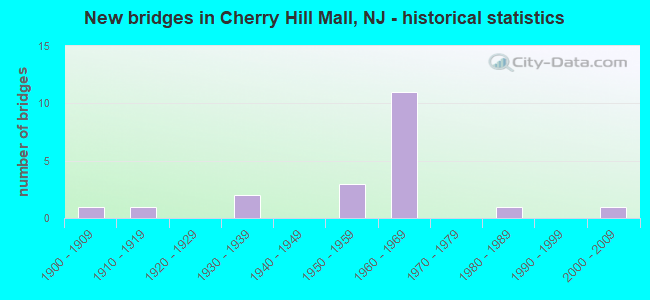
- New bridges - historical statistics
- 11900-1909
- 11910-1919
- 21930-1939
- 31950-1959
- 111960-1969
- 11980-1989
- 12000-2009

- Reconstructed bridges - Historical Statistics
- 11940-1949
- 11950-1959


- Bridge Condition - Deck
- 10.0%Good
- 60.0%Satisfactory
- 30.0%Fair

- Bridge Condition - Superstructure
- 8.3%Very good
- 75.0%Satisfactory
- 16.7%Fair

- Bridge Condition - Substructure
- 8.3%Very good
- 25.0%Good
- 50.0%Satisfactory
- 16.7%Fair

- Bridge Condition - Channel
- 33.3%Good
- 33.3%Satisfactory
- 22.2%Fair
- 11.1%Serious

- Bridge Condition - Culverts
- 33.3%Good
- 66.7%Satisfactory
Find on map >> Show street view
Structure Number: 314154, Location: 0.9 MI NORTH OF I295 INT (Lat: 39.943119, Lng: -74.978550), Route carried "on" structure: State highway 73, Year Built: 1966, Status: Open, Structure Length: 6.34m (20.80ft), Average Daily Traffic: 40,786 (year 2020), Truck Traffic: 4%, Average Future Daily Traffic: 54,314 (year 2040), Design Load: HL 93, Features Intersected: NJ 38
Minimum Vertical Clearance: 30+ m (98+ ft), Kilometerpoint: 45.947, Lanes on structure: 3, Lanes under structure: 6, Base Highway Network: Yes, Owner: State Highway Agency, Approaching Roadway Width: 11.6m (38.1ft), Skew: 4 degrees, Material/Design: Steel, Design/Construction: Stringer/Multi-beam, Number Of Spans In Main Unit: 2, Length of Maximum Span: 30.8m (101.0ft), Curb or Sidewalk Widths: Left: 0.6m (2.0ft), Right: 1.1m (3.6ft), Curb-To-Curb Width: 11.6m (38.1ft), Out-to-Out Width: 18.0m (59.1ft)
Condition: Deck: Satisfactory, Superstructure: Satisfactory, Substructure: Good, Operating Rating: 48.0 metric tons, Method Used To Determine Operating Rating: Load and Resistance Factor Rating (LRFR) rating reported by rating factor(RF) method using HL-93 loadings, Inventory Rating: 36.9 metric tons, Method Used To Determine Inventory Rating: Load and Resistance Factor Rating (LRFR) rating reported by rating factor(RF) method using HL-93 loadings, Structural Evaluation: Equal to present minimum criteria, Deck Geometry: High priority of replacement, Underclear: Equal to present minimum criteria, Approach Roadway Alignment: Better than present minimum criteria, Length Of Structure Improvement: 6.34m (20.80ft), Designated Inspection Frequency: Every 24 months, Inspection Date: September 2020, Bridge Improvement Cost: $76,000, Roadway Improvement Cost: $19,000, Total Project Cost: $128,000 ( Estimate for 2020), Deck Structure Type: Concrete Cast-file-Place, Wearing Surface/Protective System: Wearing Surface: Monolithic Concrete
Find on map >> Show street view
Structure Number: 314155, Location: 0.9 MI N EXIT 36 I-295 (Lat: 39.943350, Lng: -74.979031), Route carried "on" structure: State highway 73, Year Built: 1966, Status: Open, Structure Length: 6.34m (20.80ft), Average Daily Traffic: 35,925 (year 2020), Truck Traffic: 4%, Average Future Daily Traffic: 43,111 (year 2040), Features Intersected: NJ 38
Minimum Vertical Clearance: 30+ m (98+ ft), Kilometerpoint: 45.963, Lanes on structure: 3, Lanes under structure: 6, Base Highway Network: Yes, Owner: State Highway Agency, Approaching Roadway Width: 11.6m (38.1ft), Skew: 4 degrees, Material/Design: Steel, Design/Construction: Stringer/Multi-beam, Number Of Spans In Main Unit: 2, Length of Maximum Span: 31.4m (103.0ft), Curb or Sidewalk Widths: Left: 1.1m (3.6ft), Right: 0.5m (1.6ft), Curb-To-Curb Width: 11.6m (38.1ft), Out-to-Out Width: 15.2m (49.9ft)
Condition: Deck: Satisfactory, Superstructure: Satisfactory, Substructure: Good, Operating Rating: 49.9 metric tons, Method Used To Determine Operating Rating: Load Factor (LF), Inventory Rating: 29.9 metric tons, Method Used To Determine Inventory Rating: Load Factor (LF), Structural Evaluation: Equal to present minimum criteria, Deck Geometry: High priority of replacement, Underclear: Equal to present minimum criteria, Approach Roadway Alignment: Better than present minimum criteria, Length Of Structure Improvement: 6.34m (20.80ft), Designated Inspection Frequency: Every 24 months, Inspection Date: September 2020, Bridge Improvement Cost: $38,000, Roadway Improvement Cost: $10,000, Total Project Cost: $65,000 ( Estimate for 2020), Deck Structure Type: Concrete Cast-file-Place, Wearing Surface/Protective System: Wearing Surface: Monolithic Concrete
Find on map >> Show street view
Structure Number: 32915, Location: 0.2 MI. SO. OF RT. 73. (Lat: 39.942969, Lng: -74.984061), Route carried "on" structure: State highway 41, Year Built: 1966, Status: Open, Structure Length: 4.51m (14.80ft), Average Daily Traffic: 16,889 (year 2021), Truck Traffic: 4%, Average Future Daily Traffic: 20,608 (year 2041), Design Load: HS 20+Mod, Features Intersected: ROUTE 38.
Minimum Vertical Clearance: 30+ m (98+ ft), Kilometerpoint: 21.533, Lanes on structure: 6, Lanes under structure: 6, Owner: State Highway Agency, Approaching Roadway Width: 24.4m (80.1ft), Skew: 30 degrees, Material/Design: Prestressed concrete, Design/Construction: Stringer/Multi-beam, Number Of Spans In Main Unit: 2, Length of Maximum Span: 21.3m (69.9ft), Curb or Sidewalk Widths: Left: 1.8m (5.9ft), Right: 1.8m (5.9ft), Curb-To-Curb Width: 24.4m (80.1ft), Out-to-Out Width: 29.7m (97.4ft)
Condition: Deck: Fair, Superstructure: Satisfactory, Substructure: Satisfactory, Operating Rating: 77.1 metric tons, Method Used To Determine Operating Rating: Load Factor (LF), Inventory Rating: 33.6 metric tons, Method Used To Determine Inventory Rating: Load Factor (LF), Structural Evaluation: Equal to present minimum criteria, Deck Geometry: Somewhat better than minimum adequacy, Underclear: Meets minimum limits, Approach Roadway Alignment: Better than present minimum criteria, Designated Inspection Frequency: Every 24 months, Inspection Date: August 2021, Deck Structure Type: Concrete Cast-file-Place, Wearing Surface/Protective System: Wearing Surface: Monolithic Concrete
Find on map >> Show street view
Structure Number: 329151, Location: 0.2 MI. NO. OF RT. 38 (Lat: 39.945450, Lng: -74.982419), Route carried "on" structure: State highway 41, Year Built: 1964, Status: Open, Structure Length: 5.33m (17.49ft), Average Daily Traffic: 16,971 (year 2019), Truck Traffic: 4%, Average Future Daily Traffic: 20,365 (year 2039), Design Load: HS 20, Features Intersected: NJ 73
Minimum Vertical Clearance: 30+ m (98+ ft), Kilometerpoint: 21.887, Lanes on structure: 5, Lanes under structure: 4, Owner: State Highway Agency, Approaching Roadway Width: 24.1m (79.1ft), Skew: 31 degrees, Material/Design: Prestressed concrete, Design/Construction: Stringer/Multi-beam, Number Of Spans In Main Unit: 2, Length of Maximum Span: 25.9m (85.0ft), Curb or Sidewalk Widths: Left: 1.8m (5.9ft), Right: 1.8m (5.9ft), Curb-To-Curb Width: 24.1m (79.1ft), Out-to-Out Width: 29.0m (95.1ft)
Condition: Deck: Satisfactory, Superstructure: Satisfactory, Substructure: Satisfactory, Operating Rating: 54.4 metric tons, Method Used To Determine Operating Rating: Field evaluation and documented engineering judgment, Inventory Rating: 32.7 metric tons, Method Used To Determine Inventory Rating: Field evaluation and documented engineering judgment, Structural Evaluation: Equal to present minimum criteria, Deck Geometry: Superior to present desirable criteria, Underclear: Equal to present minimum criteria, Approach Roadway Alignment: Equal to present minimum criteria, Designated Inspection Frequency: Every 24 months, Inspection Date: August 2021, Deck Structure Type: Concrete Cast-file-Place, Wearing Surface/Protective System: Wearing Surface: Monolithic Concrete
Find on map >> Show street view
Structure Number: 40315, Location: 0.41 MI E OF RT 38 (Lat: 39.938439, Lng: -75.003831), Route carried "on" structure: County highway 616, Year Built: 1980, Status: Open, Structure Length: 0.67m (2.20ft), Average Daily Traffic: 10,295 (year 2021), Truck Traffic: 4%, Average Future Daily Traffic: 12,354 (year 2041), Features Intersected: S Branch Pennsauken Crk
Minimum Vertical Clearance: 30+ m (98+ ft), Kilometerpoint: 6.453, Lanes on structure: 2, Owner: County Highway Agency, Maintenance Responsibility: Town or Township Highway Agency, Approaching Roadway Width: 9.1m (29.9ft), Material/Design: Concrete, Design/Construction: Culvert, Number Of Spans In Main Unit: 2, Length of Maximum Span: 3.0m (9.8ft), Curb or Sidewalk Widths: Left: 2.5m (8.2ft), Right: 2.5m (8.2ft)
Condition: Channel: Good, Culverts: Satisfactory, Operating Rating: 54.4 metric tons, Method Used To Determine Operating Rating: Field evaluation and documented engineering judgment, Inventory Rating: 32.7 metric tons, Method Used To Determine Inventory Rating: Field evaluation and documented engineering judgment, Structural Evaluation: Equal to present minimum criteria, Waterway Adequacy: Better than present minimum criteria, Approach Roadway Alignment: Equal to present desirable criteria, Designated Inspection Frequency: Every 24 months, Inspection Date: April 2021
Find on map >> Show street view
Structure Number: 403152, Location: 0.47 MI FROM RT 41 (Lat: 39.926600, Lng: -74.987631), Route carried "on" structure: City street , Year Built: 1965, Status: Open, Structure Length: 0.64m (2.10ft), Average Daily Traffic: 106 (year 2021), Truck Traffic: 1%, Average Future Daily Traffic: 127 (year 2041), Design Load: HS 20, Features Intersected: Pennsauken Creek S BR TR, Facility Carried by Structure: King George Rd
Minimum Vertical Clearance: 30+ m (98+ ft), Kilometerpoint: 0.000, Lanes on structure: 2, Owner: County Highway Agency, Maintenance Responsibility: Town or Township Highway Agency, Approaching Roadway Width: 8.8m (28.9ft), Material/Design: Concrete, Design/Construction: Culvert, Number Of Spans In Main Unit: 2, Length of Maximum Span: 2.7m (8.9ft), Curb or Sidewalk Widths: Left: 2.9m (9.5ft), Right: 2.9m (9.5ft), Curb-To-Curb Width: 9.0m (29.5ft), Out-to-Out Width: 15.6m (51.2ft)
Condition: Channel: Fair, Culverts: Satisfactory, Operating Rating: 54.4 metric tons, Method Used To Determine Operating Rating: Field evaluation and documented engineering judgment, Inventory Rating: 32.7 metric tons, Method Used To Determine Inventory Rating: Field evaluation and documented engineering judgment, Structural Evaluation: Equal to present minimum criteria, Deck Geometry: Equal to present minimum criteria, Waterway Adequacy: Equal to present desirable criteria, Approach Roadway Alignment: Better than present minimum criteria, Designated Inspection Frequency: Every 24 months, Inspection Date: May 2021
Find on map >> Show street view
Structure Number: 408155, Location: 1.3 mi N of NJ 70 (Lat: 39.938219, Lng: -75.030000), Route carried "on" structure: County highway 644, Year Built: 1957, Status: Open, Structure Length: 3.38m (11.09ft), Average Daily Traffic: 29,593 (year 2021), Truck Traffic: 4%, Average Future Daily Traffic: 36,109 (year 2041), Design Load: HS 20, Features Intersected: NJ 38
Minimum Vertical Clearance: 30+ m (98+ ft), Kilometerpoint: 4.941, Lanes on structure: 4, Lanes under structure: 6, Base Highway Network: Yes, Owner: State Highway Agency, Approaching Roadway Width: 14.6m (47.9ft), Skew: 1 degrees, Material/Design: Prestressed concrete, Design/Construction: Stringer/Multi-beam, Number Of Spans In Main Unit: 2, Length of Maximum Span: 16.5m (54.1ft), Curb or Sidewalk Widths: Left: 1.8m (5.9ft), Right: 1.8m (5.9ft), Curb-To-Curb Width: 14.6m (47.9ft), Out-to-Out Width: 18.9m (62.0ft)
Condition: Deck: Satisfactory, Superstructure: Satisfactory, Substructure: Good, Operating Rating: 50.8 metric tons, Method Used To Determine Operating Rating: Field evaluation and documented engineering judgment, Inventory Rating: 30.8 metric tons, Method Used To Determine Inventory Rating: Field evaluation and documented engineering judgment, Structural Evaluation: Equal to present minimum criteria, Deck Geometry: High priority of replacement, Underclear: Meets minimum limits, Approach Roadway Alignment: Equal to present desirable criteria, Length Of Structure Improvement: 3.38m (11.09ft), Designated Inspection Frequency: Every 24 months, Inspection Date: May 2021, Bridge Improvement Cost: $126,000, Roadway Improvement Cost: $15,000, Total Project Cost: $200,000 ( Estimate for 2021), Deck Structure Type: Concrete Cast-file-Place, Wearing Surface/Protective System: Wearing Surface: Bituminous
Find on map >> Show street view
Structure Number: 40816, Location: 0.8 MI WEST OF RT 41 (Lat: 39.941700, Lng: -75.000889), Route carried "on" structure: City street , Year Built: 1909, Year Reconstructed: 1954, Status: Open, Structure Length: 0.85m (2.79ft), Average Daily Traffic: 9,939 (year 2021), Truck Traffic: 3%, Average Future Daily Traffic: 12,126 (year 2041), Features Intersected: S. BR. PENNSAUKEN CREEK, Facility Carried by Structure: MILL ROAD
Minimum Vertical Clearance: 30+ m (98+ ft), Kilometerpoint: 0.048, Lanes on structure: 2, Owner: State Highway Agency, Approaching Roadway Width: 10.7m (35.1ft), Material/Design: Concrete, Design/Construction: Arch - Deck, Number Of Spans In Main Unit: 1, Length of Maximum Span: 8.5m (27.9ft), Curb or Sidewalk Widths: Left: 2.3m (7.5ft), Right: 2.4m (7.9ft), Curb-To-Curb Width: 10.6m (34.8ft), Out-to-Out Width: 15.9m (52.2ft)
Condition: Superstructure: Satisfactory, Substructure: Satisfactory, Channel: Serious, Inventory Rating: 56.2 metric tons, Method Used To Determine Inventory Rating: Load Factor (LF), Structural Evaluation: Equal to present minimum criteria, Deck Geometry: Meets minimum limits, Waterway Adequacy: Equal to present minimum criteria, Approach Roadway Alignment: Better than present minimum criteria, Length Of Structure Improvement: 0.85m (2.79ft), Designated Inspection Frequency: Every 24 months, Inspection Date: May 2021, Bridge Improvement Cost: $273,000, Total Project Cost: $314,000 ( Estimate for 2021)
Find on map >> Show street view
Structure Number: 408161, Location: 0.56 Mi. E. of Rte 616 (Lat: 39.941439, Lng: -75.000161), Route carried "on" structure: State highway 38, Year Built: 1932, Year Reconstructed: 1959, Status: Open, Structure Length: 0.88m (2.89ft), Average Daily Traffic: 56,855 (year 2020), Truck Traffic: 4%, Average Future Daily Traffic: 69,374 (year 2040), Features Intersected: SO. BR. PENNSAUKEN CREEK
Minimum Vertical Clearance: 30+ m (98+ ft), Kilometerpoint: 7.113, Lanes on structure: 4, Base Highway Network: Yes, Owner: State Highway Agency, Approaching Roadway Width: 24.4m (80.1ft), Skew: 30 degrees, Material/Design: Steel, Design/Construction: Stringer/Multi-beam, Number Of Spans In Main Unit: 1, Length of Maximum Span: 7.6m (24.9ft), Curb or Sidewalk Widths: Left: 1.8m (5.9ft), Right: 1.8m (5.9ft), Curb-To-Curb Width: 24.4m (80.1ft), Out-to-Out Width: 29.3m (96.1ft)
Condition: Deck: Satisfactory, Superstructure: Satisfactory, Substructure: Fair, Channel: Satisfactory, Operating Rating: 73.5 metric tons, Method Used To Determine Operating Rating: Load Factor (LF), Inventory Rating: 43.5 metric tons, Method Used To Determine Inventory Rating: Load Factor (LF), Structural Evaluation: Somewhat better than minimum adequacy, Deck Geometry: Superior to present desirable criteria, Waterway Adequacy: Equal to present minimum criteria, Approach Roadway Alignment: Equal to present desirable criteria, Designated Inspection Frequency: Every 24 months, Underwater Inspection Frequency: Every 48 months, Inspection Date: August 2020, Underwater Inspection Date: May 2018, Deck Structure Type: Concrete Cast-file-Place, Wearing Surface/Protective System: Wearing Surface: Bituminous
Find on map >> Show street view
Structure Number: 41015, Location: 0.2 MILES SOUTH OF RT.38 (Lat: 39.940339, Lng: -74.981500), Route carried "on" structure: Ramp State highway 41, Year Built: 1957, Status: Open, Structure Length: 0.82m (2.69ft), Average Daily Traffic: 1,377 (year 2021), Truck Traffic: 4%, Average Future Daily Traffic: 1,680 (year 2041), Design Load: HS 20, Features Intersected: PENNSAUKEN CREEK
Minimum Vertical Clearance: 30+ m (98+ ft), Kilometerpoint: 21.147, Lanes on structure: 2, Owner: State Highway Agency, Approaching Roadway Width: 13.4m (44.0ft), Material/Design: Concrete, Design/Construction: Slab, Number Of Spans In Main Unit: 1, Length of Maximum Span: 7.6m (24.9ft), Curb or Sidewalk Widths: Left: 1.8m (5.9ft), Right: 1.8m (5.9ft), Curb-To-Curb Width: 13.4m (44.0ft), Out-to-Out Width: 17.7m (58.1ft)
Condition: Deck: Satisfactory, Superstructure: Satisfactory, Substructure: Satisfactory, Channel: Fair, Operating Rating: 61.7 metric tons, Method Used To Determine Operating Rating: Load Factor (LF), Inventory Rating: 36.3 metric tons, Method Used To Determine Inventory Rating: Load Factor (LF), Structural Evaluation: Equal to present minimum criteria, Deck Geometry: Superior to present desirable criteria, Waterway Adequacy: Equal to present minimum criteria, Approach Roadway Alignment: Better than present minimum criteria, Designated Inspection Frequency: Every 24 months, Inspection Date: May 2021, Deck Structure Type: Concrete Cast-file-Place, Wearing Surface/Protective System: Wearing Surface: Bituminous
Find on map >> Show street view
Structure Number: 410151, Location: 0.2 MILES SOUTH OF RT.38 (Lat: 39.940311, Lng: -74.982519), Route carried "on" structure: State highway 41, Year Built: 1967, Status: Open, Structure Length: 0.76m (2.49ft), Average Daily Traffic: 27,790 (year 2021), Truck Traffic: 4%, Average Future Daily Traffic: 33,909 (year 2041), Design Load: HS 20+Mod, Features Intersected: S. BR PENNSAUKEN CREEK
Minimum Vertical Clearance: 30+ m (98+ ft), Kilometerpoint: 21.227, Lanes on structure: 5, Owner: State Highway Agency, Approaching Roadway Width: 23.8m (78.1ft), Skew: 30 degrees, Material/Design: Concrete, Design/Construction: Culvert, Number Of Spans In Main Unit: 1, Length of Maximum Span: 7.6m (24.9ft)
Condition: Channel: Good, Culverts: Good, Operating Rating: 96.9 metric tons, Method Used To Determine Operating Rating: Load Factor (LF) rating reported by rating factor (RF) method using MS18 loading, Inventory Rating: 90.1 metric tons, Method Used To Determine Inventory Rating: Load Factor (LF) rating reported by rating factor (RF) method using MS18 loading, Structural Evaluation: Better than present minimum criteria, Waterway Adequacy: Better than present minimum criteria, Approach Roadway Alignment: Better than present minimum criteria, Designated Inspection Frequency: Every 24 months, Inspection Date: May 2021
Find on map >> Show street view
Structure Number: 42D009, Location: 1.39 MI W OF RT 73 (Lat: 39.954131, Lng: -75.013469), Route carried "on" structure: County highway 537, Year Built: 1919, Status: Open, Structure Length: 1.52m (4.99ft), Average Daily Traffic: 12,800 (year 2021), Truck Traffic: 4%, Average Future Daily Traffic: 15,360 (year 2041), Design Load: HS 20, Features Intersected: S. BRANCH PENNSAUKEN CK
Minimum Vertical Clearance: 30+ m (98+ ft), Kilometerpoint: 10.107, Lanes on structure: 2, Owner: County Highway Agency, Approaching Roadway Width: 13.4m (44.0ft), Material/Design: Concrete, Design/Construction: Arch - Deck, Number Of Spans In Main Unit: 1, Length of Maximum Span: 10.4m (34.1ft), Curb or Sidewalk Widths: Left: 2.8m (9.2ft), Right: 2.8m (9.2ft), Curb-To-Curb Width: 13.6m (44.6ft), Out-to-Out Width: 20.1m (65.9ft)
Condition: Superstructure: Satisfactory, Substructure: Satisfactory, Channel: Good, Structural Evaluation: Equal to present minimum criteria, Deck Geometry: Superior to present desirable criteria, Waterway Adequacy: Superior to present desirable criteria, Approach Roadway Alignment: Equal to present desirable criteria, Length Of Structure Improvement: 1.04m (3.41ft), Designated Inspection Frequency: Every 24 months, Underwater Inspection Frequency: Every 48 months, Inspection Date: Febuary 2021, Underwater Inspection Date: Febuary 2019, Bridge Improvement Cost: $99,000, Total Project Cost: $99,000 ( Estimate for 2015)
Find on map >> Show street view
Structure Number: 42D01, Location: .29 MI N OF NJ RTE 38 (Lat: 39.945019, Lng: -75.009211), Route carried "on" structure: County highway 627, Year Built: 1962, Status: Open, Structure Length: 0.98m (3.22ft), Average Daily Traffic: 11,018 (year 2021), Truck Traffic: 3%, Average Future Daily Traffic: 13,222 (year 2041), Design Load: HS 20, Features Intersected: S BR PENNSAUKEN CREEK
Minimum Vertical Clearance: 30+ m (98+ ft), Kilometerpoint: 3.557, Lanes on structure: 2, Owner: County Highway Agency, Approaching Roadway Width: 11.0m (36.1ft), Material/Design: Prestressed concrete, Design/Construction: Box Beam or Girders - Multiple, Number Of Spans In Main Unit: 1, Length of Maximum Span: 9.1m (29.9ft), Curb or Sidewalk Widths: Left: 1.8m (5.9ft), Right: 1.8m (5.9ft), Curb-To-Curb Width: 11.0m (36.1ft), Out-to-Out Width: 15.1m (49.5ft)
Condition: Deck: Fair, Superstructure: Fair, Substructure: Satisfactory, Channel: Satisfactory, Operating Rating: 46.3 metric tons, Method Used To Determine Operating Rating: Load Factor (LF), Inventory Rating: 27.2 metric tons, Method Used To Determine Inventory Rating: Load Factor (LF), Structural Evaluation: Somewhat better than minimum adequacy, Deck Geometry: Meets minimum limits, Waterway Adequacy: Equal to present minimum criteria, Approach Roadway Alignment: Equal to present desirable criteria, Designated Inspection Frequency: Every 24 months, Inspection Date: Febuary 2021, Deck Structure Type: Concrete Precast Panels, Wearing Surface/Protective System: Wearing Surface: Bituminous
Find on map >> Show street view
Structure Number: 43E007, Location: 0.44 M E OF KINGSHWY RT41 (Lat: 39.931281, Lng: -74.981261), Route carried "on" structure: County highway 616, Year Built: 1933, Status: Open, Structure Length: 0.88m (2.89ft), Average Daily Traffic: 10,295 (year 2021), Truck Traffic: 4%, Average Future Daily Traffic: 12,354 (year 2041), Features Intersected: S BR PENNSAUKEN CREEK, Facility Carried by Structure: CHURCH RD
Minimum Vertical Clearance: 30+ m (98+ ft), Kilometerpoint: 8.546, Lanes on structure: 2, Owner: County Highway Agency, Approaching Roadway Width: 10.4m (34.1ft), Material/Design: Concrete, Design/Construction: Frame, Number Of Spans In Main Unit: 1, Length of Maximum Span: 8.2m (26.9ft), Curb or Sidewalk Widths: Left: 2.0m (6.6ft), Right: 1.9m (6.2ft), Curb-To-Curb Width: 10.4m (34.1ft), Out-to-Out Width: 15.1m (49.5ft)
Condition: Deck: Fair, Superstructure: Fair, Substructure: Fair, Channel: Satisfactory, Inventory Rating: 72.6 metric tons, Method Used To Determine Inventory Rating: Load Factor (LF), Structural Evaluation: Somewhat better than minimum adequacy, Deck Geometry: Meets minimum limits, Waterway Adequacy: Equal to present desirable criteria, Approach Roadway Alignment: Equal to present desirable criteria, Designated Inspection Frequency: Every 24 months, Inspection Date: Febuary 2021, Deck Structure Type: Concrete Cast-file-Place, Wearing Surface/Protective System: Wearing Surface: Bituminous
Find on map >> Show street view
Structure Number: 466153, Location: 0.4 MILES WEST OF NJ 38 (Lat: 39.941181, Lng: -75.040211), Route carried "on" structure: County highway 626, Year Built: 2009, Status: Open, Structure Length: 2.96m (9.71ft), Average Daily Traffic: 5,613 (year 2020), Truck Traffic: 4%, Average Future Daily Traffic: 6,736 (year 2040), Design Load: HL 93, Features Intersected: ATLANTIC CITY LINE
Minimum Vertical Clearance: 30+ m (98+ ft), Kilometerpoint: 1.432, Lanes on structure: 2, Owner: State Agenciy, Approaching Roadway Width: 9.1m (29.9ft), Skew: 3 degrees, Material/Design: Steel, Design/Construction: Stringer/Multi-beam, Number Of Spans In Main Unit: 1, Length of Maximum Span: 27.4m (89.9ft), Curb or Sidewalk Widths: Left: 1.8m (5.9ft), Right: 1.8m (5.9ft), Curb-To-Curb Width: 9.1m (29.9ft), Out-to-Out Width: 13.6m (44.6ft)
Condition: Deck: Good, Superstructure: Very good, Substructure: Very good, Operating Rating: 75.8 metric tons, Method Used To Determine Operating Rating: Load and Resistance Factor Rating (LRFR) rating reported by rating factor(RF) method using HL-93 loadings, Inventory Rating: 59.3 metric tons, Method Used To Determine Inventory Rating: Load and Resistance Factor Rating (LRFR) rating reported by rating factor(RF) method using HL-93 loadings, Structural Evaluation: Equal to present desirable criteria, Deck Geometry: High priority of corrective action, Underclear: Meets minimum limits, Approach Roadway Alignment: Better than present minimum criteria, Length Of Structure Improvement: 2.96m (9.71ft), Designated Inspection Frequency: Every 24 months, Inspection Date: November 2020, Bridge Improvement Cost: $39,000, Roadway Improvement Cost: $4,000, Total Project Cost: $57,000 ( Estimate for 2020), Deck Structure Type: Concrete Cast-file-Place, Wearing Surface/Protective System: Deck Protection: Epoxy Coated Reinforcing
Find on map >> Show street view
Structure Number: 314154, Location: 0.9 MI NORTH OF I295 INT (Lat: 39.943119, Lng: -74.978550), Route carried "under" structure: State highway 38, Year Built: 1966, Structure Length: 0. m, Average Daily Traffic: 47,967 (year 2020), Truck Traffic: 4%, Features Intersected: NJ 38, Facility Carried by Structure: NJ 73 NB
Minimum Vertical Clearance: 5.23m (17.16ft), Kilometerpoint: 8.980, Lanes on structure: 3, Lanes under structure: 6, Material/Design: Steel, Design/Construction: Stringer/Multi-beam, Length of Maximum Span: 30.8m (101.0ft)
Find on map >> Show street view
Structure Number: 314155, Location: 0.9 MI N EXIT 36 I-295 (Lat: 39.943350, Lng: -74.979031), Route carried "under" structure: State highway 38, Year Built: 1966, Structure Length: 0. m, Average Daily Traffic: 36,856 (year 2020), Truck Traffic: 4%, Features Intersected: NJ 38, Facility Carried by Structure: NJ 73 SB
Minimum Vertical Clearance: 5.46m (17.91ft), Kilometerpoint: 8.996, Lanes on structure: 3, Lanes under structure: 6, Material/Design: Steel, Design/Construction: Stringer/Multi-beam, Length of Maximum Span: 31.4m (103.0ft)
Find on map >> Show street view
Structure Number: 32915, Location: 0.2 MI. SO. OF RT. 73. (Lat: 39.942969, Lng: -74.984061), Route carried "under" structure: State highway 38, Year Built: 1966, Structure Length: 0. m, Average Daily Traffic: 69,939 (year 2021), Truck Traffic: 4%, Features Intersected: ROUTE 38., Facility Carried by Structure: RTE 41.
Minimum Vertical Clearance: 4.44m (14.57ft), Kilometerpoint: 8.497, Lanes on structure: 6, Lanes under structure: 6, Material/Design: Prestressed concrete, Design/Construction: Stringer/Multi-beam, Length of Maximum Span: 21.3m (69.9ft)
Find on map >> Show street view
Structure Number: 329151, Location: 0.2 MI. NO. OF RT. 38 (Lat: 39.945450, Lng: -74.982419), Route carried "under" structure: State highway 73, Year Built: 1964, Structure Length: 0. m, Average Daily Traffic: 87,987 (year 2019), Truck Traffic: 4%, Features Intersected: NJ 73, Facility Carried by Structure: NJ 41
Minimum Vertical Clearance: 4.70m (15.42ft), Kilometerpoint: 46.381, Lanes on structure: 5, Lanes under structure: 4, Material/Design: Prestressed concrete, Design/Construction: Stringer/Multi-beam, Length of Maximum Span: 25.9m (85.0ft)
Find on map >> Show street view
Structure Number: 408155, Location: 1.3 mi N of NJ 70 (Lat: 39.938219, Lng: -75.030000), Route carried "under" structure: State highway 38, Year Built: 1957, Structure Length: 0. m, Average Daily Traffic: 53,335 (year 2021), Truck Traffic: 4%, Features Intersected: NJ 38, Facility Carried by Structure: CR 644
Minimum Vertical Clearance: 4.71m (15.45ft), Kilometerpoint: 4.506, Lanes on structure: 4, Lanes under structure: 6, Material/Design: Prestressed concrete, Design/Construction: Stringer/Multi-beam, Length of Maximum Span: 16.5m (54.1ft)