Bridge Statistics for Chili, New York (NY)
Condition, Traffic, Stress, Structural Evaluation, Project Costs
- National Bridge Inventory (NBI) Statistics
- 41Number of bridges
- 502ft / 153mTotal length
- $115,294,000Total costs
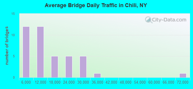
- 542,017Total average daily traffic
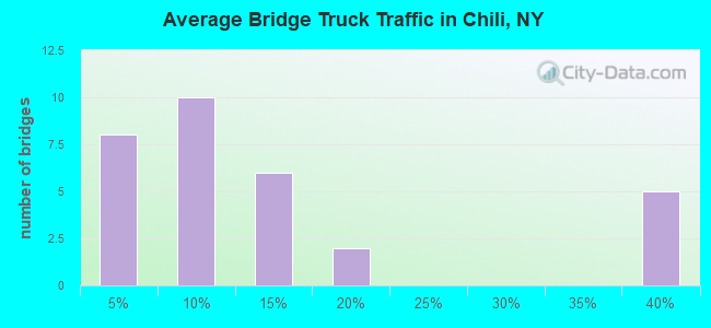
- 53,779Total average daily truck traffic
- National Bridge Inventory (NBI) Registered Bridges for Chili
- No street view available for this location
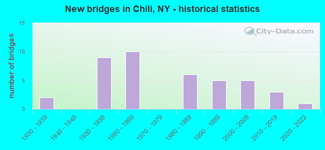
- New bridges - historical statistics
- 21930-1939
- 91950-1959
- 101960-1969
- 61980-1989
- 51990-1999
- 52000-2009
- 32010-2019
- 12020-2022
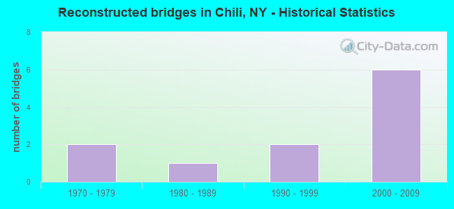
- Reconstructed bridges - Historical Statistics
- 21970-1979
- 11980-1989
- 21990-1999
- 62000-2009
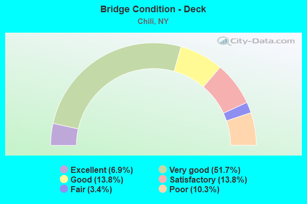
- Bridge Condition - Deck
- 6.9%Excellent
- 51.7%Very good
- 13.8%Good
- 13.8%Satisfactory
- 3.4%Fair
- 10.3%Poor
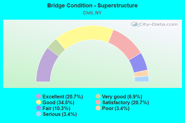
- Bridge Condition - Superstructure
- 20.7%Excellent
- 6.9%Very good
- 34.5%Good
- 20.7%Satisfactory
- 10.3%Fair
- 3.4%Poor
- 3.4%Serious
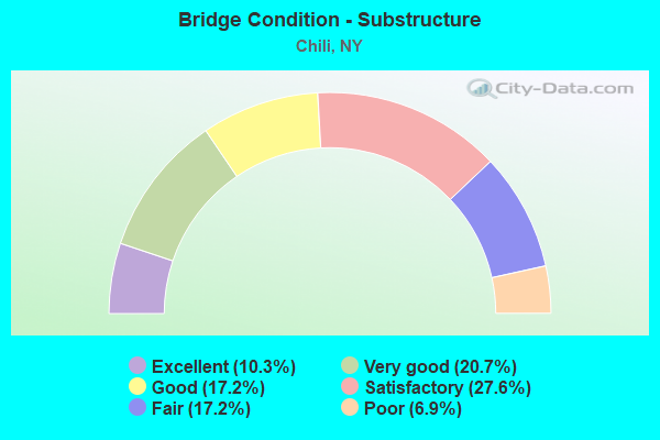
- Bridge Condition - Substructure
- 10.3%Excellent
- 20.7%Very good
- 17.2%Good
- 27.6%Satisfactory
- 17.2%Fair
- 6.9%Poor
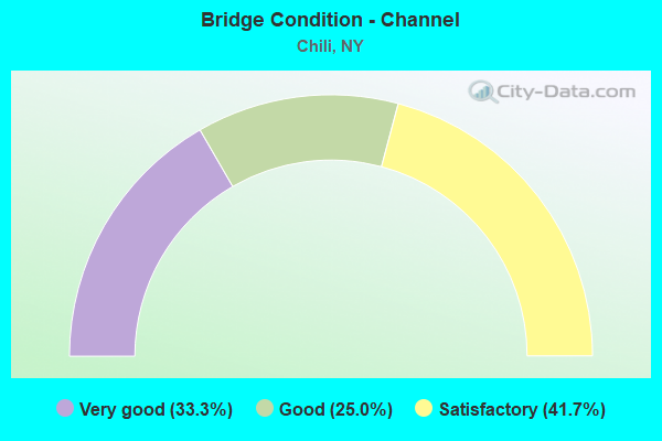
- Bridge Condition - Channel
- 33.3%Very good
- 25.0%Good
- 41.7%Satisfactory
Find on map >> Show street view
Structure Number: 102308, Location: JCT RTE33A+BLACK CREEK (Lat: 43.084344, Lng: -77.815289), Route carried "on" structure: Alternate State highway 33A, Year Built: 2020, Status: Open, Structure Length: 4.51m (14.80ft), Average Daily Traffic: 2,241 (year 2020), Truck Traffic: 7%, Average Future Daily Traffic: 2,722 (year 2040), Design Load: HL 93, Features Intersected: BLACK CREEK
Minimum Vertical Clearance: 30+ m (98+ ft), Kilometerpoint: 10.491, Lanes on structure: 2, Base Highway Network: Yes, Owner: State Highway Agency, Approaching Roadway Width: 10.4m (34.1ft), Material/Design: Steel, Design/Construction: Stringer/Multi-beam, Number Of Spans In Main Unit: 1, Length of Maximum Span: 44.8m (147.0ft), Curb-To-Curb Width: 10.4m (34.1ft), Out-to-Out Width: 11.4m (37.4ft)
Condition: Deck: Excellent, Superstructure: Excellent, Substructure: Excellent, Channel: Very good, Inventory Rating: 78.9 metric tons, Method Used To Determine Inventory Rating: Load Factor (LF), Structural Evaluation: Superior to present desirable criteria, Deck Geometry: Somewhat better than minimum adequacy, Waterway Adequacy: Superior to present desirable criteria, Approach Roadway Alignment: Equal to present desirable criteria, Length Of Structure Improvement: 4.51m (14.80ft), Designated Inspection Frequency: Every 24 months, Inspection Date: December 2020, Bridge Improvement Cost: $1,248,000, Roadway Improvement Cost: $731,000, Total Project Cost: $1,978,000 ( Estimate for 2021), Deck Structure Type: Concrete Cast-file-Place, Wearing Surface/Protective System: Wearing Surface: Integral Concrete, Deck Protection: Epoxy Coated Reinforcing
Find on map >> Show street view
Structure Number: 104333, Location: JCT RTE 251+BLACK CREEK (Lat: 43.088164, Lng: -77.759172), Route carried "on" structure: State highway 386, Year Built: 1931, Year Reconstructed: 1990, Status: Posted for load, Structure Length: 3.14m (10.30ft), Average Daily Traffic: 2,351 (year 2020), Truck Traffic: 3%, Average Future Daily Traffic: 2,855 (year 2040), Design Load: HS 20, Features Intersected: BLACK CREEK
Minimum Vertical Clearance: 30+ m (98+ ft), Kilometerpoint: 8.930, Lanes on structure: 2, Base Highway Network: Yes, Owner: State Highway Agency, Approaching Roadway Width: 7.9m (25.9ft), Material/Design: Steel, Design/Construction: Truss - Thru, Number Of Spans In Main Unit: 1, Length of Maximum Span: 30.4m (99.7ft), Curb-To-Curb Width: 7.3m (24.0ft), Out-to-Out Width: 8.8m (28.9ft)
Condition: Deck: Fair, Superstructure: Serious, Substructure: Fair, Channel: Satisfactory, Operating Rating: 5.4 metric tons, Method Used To Determine Operating Rating: Load Factor (LF), Inventory Rating: 2.7 metric tons, Method Used To Determine Inventory Rating: Load Factor (LF), Structural Evaluation: High priority of corrective action, Deck Geometry: High priority of replacement, Waterway Adequacy: Equal to present minimum criteria, Approach Roadway Alignment: Equal to present minimum criteria, Bridge Posting: Required (Relationship of Operating Rating to Maximum Legal Load: > 39.9% below), Length Of Structure Improvement: 3.13m (10.27ft), Designated Inspection Frequency: Every 12 months, Critical Feature Inspection Frequency: Every 12 months, Inspection Date: October 2021, Critical Feature Inspection Date: October 2021, Bridge Improvement Cost: $2,814,000, Roadway Improvement Cost: $1,648,000, Total Project Cost: $4,462,000 ( Estimate for 2021), Deck Structure Type: Concrete Cast-file-Place, Wearing Surface/Protective System: Wearing Surface: Monolithic Concrete
Find on map >> Show street view
Structure Number: 104334, Location: 6.5 MI W OF EXIT 46-90I (Lat: 43.044367, Lng: -77.779361), Route carried "on" structure: State highway 386, Year Built: 1993, Status: Open, Structure Length: 6.64m (21.78ft), Average Daily Traffic: 2,757 (year 2020), Truck Traffic: 5%, Average Future Daily Traffic: 2,774 (year 2040), Design Load: HS 25 or greater, Features Intersected: 90IX EB, RTE I90
Minimum Vertical Clearance: 30+ m (98+ ft), Kilometerpoint: 3.347, Lanes on structure: 2, Lanes under structure: 4, Base Highway Network: Yes, Owner: State Toll Authority, Approaching Roadway Width: 9.8m (32.2ft), Material/Design: Steel continuous, Design/Construction: Stringer/Multi-beam, Number Of Spans In Main Unit: 2, Length of Maximum Span: 33.5m (109.9ft), Curb-To-Curb Width: 9.0m (29.5ft), Out-to-Out Width: 9.9m (32.5ft)
Condition: Deck: Good, Superstructure: Satisfactory, Substructure: Good, Operating Rating: 76.2 metric tons, Method Used To Determine Operating Rating: Load Factor (LF), Inventory Rating: 41.7 metric tons, Method Used To Determine Inventory Rating: Load Factor (LF), Structural Evaluation: Equal to present minimum criteria, Deck Geometry: Meets minimum limits, Underclear: High priority of corrective action, Approach Roadway Alignment: Equal to present minimum criteria, Length Of Structure Improvement: 6.64m (21.78ft), Designated Inspection Frequency: Every 24 months, Inspection Date: March 2021, Bridge Improvement Cost: $1,536,000, Roadway Improvement Cost: $900,000, Total Project Cost: $2,436,000 ( Estimate for 2021), Deck Structure Type: Concrete Cast-file-Place, Wearing Surface/Protective System: Wearing Surface: Integral Concrete, Deck Protection: Epoxy Coated Reinforcing
Find on map >> Show street view
Structure Number: 104341, Location: JCT RTE252 +GENESEERIVER (Lat: 43.092453, Lng: -77.679858), Route carried "on" structure: State highway 252, Year Built: 2003, Status: Open, Structure Length: 11.31m (37.11ft), Average Daily Traffic: 21,859 (year 2019), Truck Traffic: 4%, Average Future Daily Traffic: 21,961 (year 2040), Design Load: HL 93, Features Intersected: GENESEE RIVER
Minimum Vertical Clearance: 32.69m (107.25ft), Kilometerpoint: 7.401, Lanes on structure: 8, Base Highway Network: Yes, Owner: State Highway Agency, Approaching Roadway Width: 43.0m (141.1ft), Material/Design: Steel continuous, Design/Construction: Stringer/Multi-beam, Number Of Spans In Main Unit: 3, Length of Maximum Span: 50.0m (164.0ft), Curb or Sidewalk Widths: Left: 1.7m (5.6ft), Right: 1.7m (5.6ft), Curb-To-Curb Width: 31.8m (104.3ft), Out-to-Out Width: 37.5m (123.0ft)
Condition: Deck: Very good, Superstructure: Very good, Substructure: Very good, Channel: Good, Operating Rating: 78.9 metric tons, Method Used To Determine Operating Rating: Load Factor (LF), Inventory Rating: 47.2 metric tons, Method Used To Determine Inventory Rating: Load Factor (LF), Structural Evaluation: Equal to present desirable criteria, Deck Geometry: High priority of corrective action, Waterway Adequacy: Equal to present desirable criteria, Approach Roadway Alignment: Equal to present minimum criteria, Length Of Structure Improvement: 11.30m (37.07ft), Designated Inspection Frequency: Every 24 months, Underwater Inspection Frequency: Every 60 months, Inspection Date: October 2020, Underwater Inspection Date: August 2017, Bridge Improvement Cost: $9,453,000, Roadway Improvement Cost: $5,536,000, Total Project Cost: $14,989,000 ( Estimate for 2021), Deck Structure Type: Concrete Cast-file-Place, Wearing Surface/Protective System: Wearing Surface: Integral Concrete, Deck Protection: Epoxy Coated Reinforcing
Find on map >> Show street view
Structure Number: 104343, Location: .3 MI NE JCT SH252A/SH383 (Lat: 43.106461, Lng: -77.679536), Route carried "on" structure: Other road 252A, Year Built: 1935, Year Reconstructed: 1998, Status: Open, Structure Length: 1.22m (4.00ft), Average Daily Traffic: 6,138 (year 2020), Truck Traffic: 12%, Average Future Daily Traffic: 7,456 (year 2040), Features Intersected: LITTLE BLACK CREEK
Minimum Vertical Clearance: 30+ m (98+ ft), Kilometerpoint: 6.565, Lanes on structure: 2, Owner: County Highway Agency, Approaching Roadway Width: 9.1m (29.9ft), Material/Design: Steel, Design/Construction: Stringer/Multi-beam, Number Of Spans In Main Unit: 1, Length of Maximum Span: 8.5m (27.9ft), Curb-To-Curb Width: 9.6m (31.5ft), Out-to-Out Width: 10.2m (33.5ft)
Condition: Deck: Satisfactory, Superstructure: Good, Substructure: Good, Channel: Good, Operating Rating: 67.1 metric tons, Method Used To Determine Operating Rating: Load Factor (LF), Inventory Rating: 39.9 metric tons, Method Used To Determine Inventory Rating: Load Factor (LF), Structural Evaluation: Better than present minimum criteria, Deck Geometry: High priority of corrective action, Waterway Adequacy: Equal to present minimum criteria, Approach Roadway Alignment: Equal to present desirable criteria, Length Of Structure Improvement: 1.21m (3.97ft), Designated Inspection Frequency: Every 24 months, Inspection Date: August 2021, Bridge Improvement Cost: $417,000, Roadway Improvement Cost: $244,000, Total Project Cost: $661,000 ( Estimate for 2021), Deck Structure Type: Concrete Cast-file-Place, Wearing Surface/Protective System: Wearing Surface: Integral Concrete
Find on map >> Show street view
Structure Number: 104721, Location: .1 MI N JCT SH383 & SH252 (Lat: 43.094494, Lng: -77.679981), Route carried "on" structure: State highway 383, Year Built: 2004, Status: Open, Structure Length: 4.24m (13.91ft), Average Daily Traffic: 12,614 (year 2020), Truck Traffic: 10%, Average Future Daily Traffic: 12,673 (year 2040), Design Load: HL 93, Features Intersected: BLACK CREEK
Minimum Vertical Clearance: 30+ m (98+ ft), Kilometerpoint: 20.595, Lanes on structure: 4, Base Highway Network: Yes, Owner: State Highway Agency, Approaching Roadway Width: 22.9m (75.1ft), Skew: 1 degrees, Material/Design: Steel, Design/Construction: Stringer/Multi-beam, Number Of Spans In Main Unit: 1, Length of Maximum Span: 41.1m (134.8ft), Curb or Sidewalk Widths: Left: 1.7m (5.6ft), Right: 0.0m, Curb-To-Curb Width: 22.8m (74.8ft), Out-to-Out Width: 25.2m (82.7ft)
Condition: Deck: Very good, Superstructure: Excellent, Substructure: Very good, Channel: Very good, Operating Rating: 88.0 metric tons, Method Used To Determine Operating Rating: Load Factor (LF), Inventory Rating: 52.6 metric tons, Method Used To Determine Inventory Rating: Load Factor (LF), Structural Evaluation: Equal to present desirable criteria, Deck Geometry: Superior to present desirable criteria, Waterway Adequacy: Somewhat better than minimum adequacy, Approach Roadway Alignment: Equal to present desirable criteria, Length Of Structure Improvement: 4.23m (13.88ft), Designated Inspection Frequency: Every 24 months, Inspection Date: May 2020, Bridge Improvement Cost: $3,088,000, Roadway Improvement Cost: $1,808,000, Total Project Cost: $4,896,000 ( Estimate for 2021), Deck Structure Type: Concrete Cast-file-Place, Wearing Surface/Protective System: Wearing Surface: Integral Concrete
Find on map >> Show street view
Structure Number: 1048591, Location: 0.6MI E JCT RTSI490WB+259 (Lat: 43.101544, Lng: -77.789333), Route carried "on" structure: Interstate 490, Year Built: 1963, Status: Open, Structure Length: 5.85m (19.19ft), Average Daily Traffic: 13,715 (year 2014), Truck Traffic: 10%, Average Future Daily Traffic: 19,200 (year 2034), Design Load: HS 20+Mod, Features Intersected: CSX TRANS/W SHORE
Minimum Vertical Clearance: 30+ m (98+ ft), Kilometerpoint: 16.219, Lanes on structure: 2, Base Highway Network: Yes, Owner: State Highway Agency, Approaching Roadway Width: 14.6m (47.9ft), Skew: 4 degrees, Material/Design: Steel, Design/Construction: Stringer/Multi-beam, Number Of Spans In Main Unit: 3, Length of Maximum Span: 18.5m (60.7ft), Curb-To-Curb Width: 12.8m (42.0ft), Out-to-Out Width: 13.8m (45.3ft)
Condition: Deck: Poor, Superstructure: Poor, Substructure: Poor, Operating Rating: 92.5 metric tons, Method Used To Determine Operating Rating: Load Factor (LF), Inventory Rating: 55.3 metric tons, Method Used To Determine Inventory Rating: Load Factor (LF), Structural Evaluation: Meets minimum limits, Deck Geometry: Equal to present desirable criteria, Underclear: Equal to present minimum criteria, Approach Roadway Alignment: Equal to present minimum criteria, Length Of Structure Improvement: 5.85m (19.19ft), Designated Inspection Frequency: Every 24 months, Inspection Date: December 2021, Bridge Improvement Cost: $1,976,000, Roadway Improvement Cost: $1,157,000, Total Project Cost: $3,133,000 ( Estimate for 2021), Deck Structure Type: Concrete Cast-file-Place, Wearing Surface/Protective System: Wearing Surface: Integral Concrete
Find on map >> Show street view
Structure Number: 1048592, Location: 0.7MI E JCT RTSI490EB+259 (Lat: 43.101519, Lng: -77.788217), Route carried "on" structure: Interstate 490, Year Built: 1963, Status: Open, Structure Length: 5.85m (19.19ft), Average Daily Traffic: 10,175 (year 2020), Truck Traffic: 14%, Average Future Daily Traffic: 14,149 (year 2040), Design Load: HS 20+Mod, Features Intersected: CSX TRANS/W SHORE
Minimum Vertical Clearance: 30+ m (98+ ft), Kilometerpoint: 16.219, Lanes on structure: 2, Base Highway Network: Yes, Owner: State Highway Agency, Approaching Roadway Width: 14.6m (47.9ft), Skew: 4 degrees, Material/Design: Steel, Design/Construction: Stringer/Multi-beam, Number Of Spans In Main Unit: 3, Length of Maximum Span: 18.5m (60.7ft), Curb-To-Curb Width: 12.8m (42.0ft), Out-to-Out Width: 13.8m (45.3ft)
Condition: Deck: Poor, Superstructure: Fair, Substructure: Fair, Operating Rating: 80.7 metric tons, Method Used To Determine Operating Rating: Load Factor (LF), Inventory Rating: 48.1 metric tons, Method Used To Determine Inventory Rating: Load Factor (LF), Structural Evaluation: Somewhat better than minimum adequacy, Deck Geometry: Equal to present desirable criteria, Underclear: High priority of corrective action, Approach Roadway Alignment: Equal to present minimum criteria, Length Of Structure Improvement: 5.85m (19.19ft), Designated Inspection Frequency: Every 24 months, Inspection Date: September 2021, Bridge Improvement Cost: $1,952,000, Roadway Improvement Cost: $1,143,000, Total Project Cost: $3,095,000 ( Estimate for 2021), Deck Structure Type: Concrete Cast-file-Place, Wearing Surface/Protective System: Wearing Surface: Integral Concrete
Find on map >> Show street view
Structure Number: 10486, Location: 1.0MI E JCT RTSI490WB+259 (Lat: 43.107506, Lng: -77.781617), Route carried "on" structure: County highway , Year Built: 1963, Year Reconstructed: 2014, Status: Open, Structure Length: 5.73m (18.80ft), Average Daily Traffic: 4,290 (year 2019), Truck Traffic: 3%, Average Future Daily Traffic: 5,211 (year 2040), Design Load: HS 20+Mod, Features Intersected: RTE I490, Facility Carried by Structure: PAUL ROAD
Minimum Vertical Clearance: 30+ m (98+ ft), Kilometerpoint: 1.158, Lanes on structure: 2, Lanes under structure: 2, Owner: State Highway Agency, Approaching Roadway Width: 9.8m (32.2ft), Skew: 4 degrees, Material/Design: Steel, Design/Construction: Stringer/Multi-beam, Number Of Spans In Main Unit: 3, Length of Maximum Span: 22.6m (74.1ft), Curb-To-Curb Width: 9.1m (29.9ft), Out-to-Out Width: 10.4m (34.1ft)
Condition: Deck: Very good, Superstructure: Satisfactory, Substructure: Fair, Operating Rating: 82.6 metric tons, Method Used To Determine Operating Rating: Load Factor (LF), Inventory Rating: 49.0 metric tons, Method Used To Determine Inventory Rating: Load Factor (LF), Structural Evaluation: Somewhat better than minimum adequacy, Deck Geometry: Meets minimum limits, Underclear: High priority of corrective action, Approach Roadway Alignment: Equal to present desirable criteria, Length Of Structure Improvement: 5.73m (18.80ft), Designated Inspection Frequency: Every 24 months, Inspection Date: August 2020, Bridge Improvement Cost: $1,427,000, Roadway Improvement Cost: $835,000, Total Project Cost: $2,262,000 ( Estimate for 2021), Deck Structure Type: Concrete Cast-file-Place, Wearing Surface/Protective System: Wearing Surface: Integral Concrete, Deck Protection: Epoxy Coated Reinforcing
Find on map >> Show street view
Structure Number: 1048611, Location: JCT RTS I490 WB + 251 (Lat: 43.121169, Lng: -77.745639), Route carried "on" structure: Interstate 490, Year Built: 1963, Year Reconstructed: 2013, Status: Open, Structure Length: 3.90m (12.80ft), Average Daily Traffic: 18,709 (year 2014), Truck Traffic: 10%, Design Load: HS 20+Mod, Features Intersected: RTE 386
Minimum Vertical Clearance: 30+ m (98+ ft), Kilometerpoint: 20.434, Lanes on structure: 2, Lanes under structure: 3, Base Highway Network: Yes, Owner: State Highway Agency, Approaching Roadway Width: 14.6m (47.9ft), Material/Design: Steel, Design/Construction: Stringer/Multi-beam, Number Of Spans In Main Unit: 3, Length of Maximum Span: 14.0m (45.9ft), Curb-To-Curb Width: 13.8m (45.3ft), Out-to-Out Width: 14.7m (48.2ft)
Condition: Deck: Very good, Superstructure: Satisfactory, Substructure: Satisfactory, Operating Rating: 63.2 metric tons, Method Used To Determine Operating Rating: Load and Resistance Factor Rating (LRFR) rating reported by rating factor(RF) method using HL-93 loadings, Inventory Rating: 48.6 metric tons, Method Used To Determine Inventory Rating: Load and Resistance Factor Rating (LRFR) rating reported by rating factor(RF) method using HL-93 loadings, Structural Evaluation: Equal to present minimum criteria, Deck Geometry: Superior to present desirable criteria, Underclear: High priority of corrective action, Approach Roadway Alignment: Equal to present desirable criteria, Length Of Structure Improvement: 3.90m (12.80ft), Designated Inspection Frequency: Every 24 months, Inspection Date: July 2021, Bridge Improvement Cost: $1,389,000, Roadway Improvement Cost: $813,000, Total Project Cost: $2,202,000 ( Estimate for 2021), Deck Structure Type: Concrete Cast-file-Place, Wearing Surface/Protective System: Wearing Surface: Integral Concrete, Deck Protection: Epoxy Coated Reinforcing
Find on map >> Show street view
Structure Number: 1048612, Location: JCT RTS I490 EB + 251 (Lat: 43.120722, Lng: -77.745636), Route carried "on" structure: Interstate 490, Year Built: 1963, Year Reconstructed: 2013, Status: Open, Structure Length: 3.90m (12.80ft), Average Daily Traffic: 11,882 (year 2020), Truck Traffic: 14%, Average Future Daily Traffic: 16,523 (year 2040), Design Load: HS 20+Mod, Features Intersected: RTE 386
Minimum Vertical Clearance: 30+ m (98+ ft), Kilometerpoint: 20.434, Lanes on structure: 2, Lanes under structure: 3, Base Highway Network: Yes, Owner: State Highway Agency, Approaching Roadway Width: 13.7m (44.9ft), Material/Design: Steel, Design/Construction: Stringer/Multi-beam, Number Of Spans In Main Unit: 3, Length of Maximum Span: 14.0m (45.9ft), Curb-To-Curb Width: 13.8m (45.3ft), Out-to-Out Width: 14.7m (48.2ft)
Condition: Deck: Very good, Superstructure: Satisfactory, Substructure: Satisfactory, Operating Rating: 63.2 metric tons, Method Used To Determine Operating Rating: Load and Resistance Factor Rating (LRFR) rating reported by rating factor(RF) method using HL-93 loadings, Inventory Rating: 48.6 metric tons, Method Used To Determine Inventory Rating: Load and Resistance Factor Rating (LRFR) rating reported by rating factor(RF) method using HL-93 loadings, Structural Evaluation: Equal to present minimum criteria, Deck Geometry: Superior to present desirable criteria, Underclear: High priority of corrective action, Approach Roadway Alignment: Equal to present minimum criteria, Length Of Structure Improvement: 3.90m (12.80ft), Designated Inspection Frequency: Every 24 months, Inspection Date: July 2021, Bridge Improvement Cost: $1,389,000, Roadway Improvement Cost: $813,000, Total Project Cost: $2,202,000 ( Estimate for 2021), Deck Structure Type: Concrete Cast-file-Place, Wearing Surface/Protective System: Wearing Surface: Integral Concrete, Deck Protection: Other Coated Reinforcing
Find on map >> Show street view
Structure Number: 106062, Location: JCT RTS 259 & I490 (Lat: 43.095492, Lng: -77.798883), Route carried "on" structure: State highway 259, Year Built: 1997, Status: Open, Structure Length: 9.45m (31.00ft), Average Daily Traffic: 8,418 (year 2020), Truck Traffic: 5%, Average Future Daily Traffic: 8,457 (year 2040), Design Load: HS 25 or greater, Features Intersected: 490I490I 43021094, RTE I
Minimum Vertical Clearance: 30+ m (98+ ft), Kilometerpoint: 0.274, Lanes on structure: 3, Lanes under structure: 8, Base Highway Network: Yes, Owner: State Highway Agency, Approaching Roadway Width: 8.5m (27.9ft), Skew: 1 degrees, Material/Design: Steel continuous, Design/Construction: Stringer/Multi-beam, Number Of Spans In Main Unit: 3, Length of Maximum Span: 31.0m (101.7ft), Curb-To-Curb Width: 14.6m (47.9ft), Out-to-Out Width: 15.4m (50.5ft)
Condition: Deck: Very good, Superstructure: Very good, Substructure: Very good, Operating Rating: 94.7 metric tons, Method Used To Determine Operating Rating: Field evaluation and documented engineering judgment, Inventory Rating: 40.8 metric tons, Method Used To Determine Inventory Rating: Field evaluation and documented engineering judgment, Structural Evaluation: Equal to present desirable criteria, Deck Geometry: Somewhat better than minimum adequacy, Underclear: High priority of corrective action, Approach Roadway Alignment: Equal to present desirable criteria, Length Of Structure Improvement: 9.44m (30.97ft), Designated Inspection Frequency: Every 24 months, Inspection Date: June 2021, Bridge Improvement Cost: $3,662,000, Roadway Improvement Cost: $2,144,000, Total Project Cost: $5,806,000 ( Estimate for 2021), Deck Structure Type: Concrete Cast-file-Place, Wearing Surface/Protective System: Wearing Surface: Integral Concrete, Deck Protection: Epoxy Coated Reinforcing
Find on map >> Show street view
Structure Number: 1070531, Location: JCT OF RTS I390 & 383 (Lat: 43.122339, Lng: -77.647497), Route carried "on" structure: Interstate 390, Year Built: 1981, Status: Open, Structure Length: 4.39m (14.40ft), Average Daily Traffic: 32,521 (year 2020), Truck Traffic: 7%, Average Future Daily Traffic: 45,226 (year 2040), Design Load: HS 20, Features Intersected: RTE 383
Minimum Vertical Clearance: 30+ m (98+ ft), Kilometerpoint: 25.857, Lanes on structure: 4, Lanes under structure: 5, Base Highway Network: Yes, Owner: State Highway Agency, Approaching Roadway Width: 20.1m (65.9ft), Skew: 2 degrees, Material/Design: Steel, Design/Construction: Stringer/Multi-beam, Number Of Spans In Main Unit: 1, Length of Maximum Span: 42.3m (138.8ft), Curb-To-Curb Width: 20.1m (65.9ft), Out-to-Out Width: 21.0m (68.9ft)
Condition: Deck: Very good, Superstructure: Good, Substructure: Satisfactory, Inventory Rating: 63.5 metric tons, Method Used To Determine Inventory Rating: Load Factor (LF), Structural Evaluation: Equal to present minimum criteria, Deck Geometry: Equal to present minimum criteria, Underclear: Somewhat better than minimum adequacy, Approach Roadway Alignment: Equal to present desirable criteria, Length Of Structure Improvement: 4.38m (14.37ft), Designated Inspection Frequency: Every 24 months, Inspection Date: April 2021, Bridge Improvement Cost: $2,696,000, Roadway Improvement Cost: $1,579,000, Total Project Cost: $4,275,000 ( Estimate for 2021), Deck Structure Type: Concrete Cast-file-Place, Wearing Surface/Protective System: Wearing Surface: Integral Concrete, Deck Protection: Epoxy Coated Reinforcing
Find on map >> Show street view
Structure Number: 1070532, Location: JCT OF RTS I390 & 383 (Lat: 43.122228, Lng: -77.647781), Route carried "on" structure: Interstate 390, Year Built: 1981, Status: Open, Structure Length: 4.39m (14.40ft), Average Daily Traffic: 67,036 (year 2009), Truck Traffic: 7%, Design Load: HS 20, Features Intersected: RTE 383
Minimum Vertical Clearance: 30+ m (98+ ft), Kilometerpoint: 25.937, Lanes on structure: 4, Lanes under structure: 5, Base Highway Network: Yes, Owner: State Highway Agency, Approaching Roadway Width: 14.6m (47.9ft), Skew: 2 degrees, Material/Design: Steel, Design/Construction: Stringer/Multi-beam, Number Of Spans In Main Unit: 1, Length of Maximum Span: 42.3m (138.8ft), Curb-To-Curb Width: 20.1m (65.9ft), Out-to-Out Width: 21.0m (68.9ft)
Condition: Deck: Very good, Superstructure: Good, Substructure: Satisfactory, Inventory Rating: 64.4 metric tons, Method Used To Determine Inventory Rating: Load Factor (LF), Structural Evaluation: Equal to present minimum criteria, Deck Geometry: Equal to present minimum criteria, Underclear: Somewhat better than minimum adequacy, Approach Roadway Alignment: Equal to present desirable criteria, Length Of Structure Improvement: 4.38m (14.37ft), Designated Inspection Frequency: Every 24 months, Inspection Date: April 2021, Bridge Improvement Cost: $2,667,000, Roadway Improvement Cost: $1,562,000, Total Project Cost: $4,229,000 ( Estimate for 2021), Deck Structure Type: Concrete Cast-file-Place, Wearing Surface/Protective System: Wearing Surface: Integral Concrete, Deck Protection: Epoxy Coated Reinforcing
Find on map >> Show street view
Structure Number: 107398, Location: .8M W INTERS RTS 259&490I (Lat: 43.107983, Lng: -77.802653), Route carried "on" structure: State highway 259, Year Built: 1989, Status: Open, Structure Length: 5.97m (19.59ft), Average Daily Traffic: 8,418 (year 2020), Truck Traffic: 5%, Average Future Daily Traffic: 8,457 (year 2040), Design Load: HS 20, Features Intersected: CSX TRANS/AMTRAK, TOWN A
Minimum Vertical Clearance: 30+ m (98+ ft), Kilometerpoint: 1.673, Lanes on structure: 2, Lanes under structure: 1, Base Highway Network: Yes, Owner: State Highway Agency, Approaching Roadway Width: 11.6m (38.1ft), Material/Design: Steel continuous, Design/Construction: Stringer/Multi-beam, Number Of Spans In Main Unit: 3, Length of Maximum Span: 24.3m (79.7ft), Curb-To-Curb Width: 11.4m (37.4ft), Out-to-Out Width: 12.4m (40.7ft)
Condition: Deck: Good, Superstructure: Good, Substructure: Satisfactory, Operating Rating: 61.7 metric tons, Method Used To Determine Operating Rating: Load Factor (LF), Inventory Rating: 36.3 metric tons, Method Used To Determine Inventory Rating: Load Factor (LF), Structural Evaluation: Equal to present minimum criteria, Deck Geometry: Meets minimum limits, Underclear: Somewhat better than minimum adequacy, Approach Roadway Alignment: Better than present minimum criteria, Length Of Structure Improvement: 5.97m (19.59ft), Designated Inspection Frequency: Every 24 months, Inspection Date: July 2021, Bridge Improvement Cost: $1,928,000, Roadway Improvement Cost: $1,129,000, Total Project Cost: $3,057,000 ( Estimate for 2021), Deck Structure Type: Concrete Cast-file-Place, Wearing Surface/Protective System: Wearing Surface: Integral Concrete, Deck Protection: Epoxy Coated Reinforcing
Find on map >> Show street view
Structure Number: 109555, Location: 1.0MI E JCT RTSI490EB+259 (Lat: 43.107472, Lng: -77.780508), Route carried "on" structure: County highway , Year Built: 1963, Year Reconstructed: 2014, Status: Open, Structure Length: 5.73m (18.80ft), Average Daily Traffic: 4,290 (year 2019), Truck Traffic: 3%, Average Future Daily Traffic: 5,211 (year 2040), Design Load: HS 20+Mod, Features Intersected: RTE I490, Facility Carried by Structure: PAUL ROAD
Minimum Vertical Clearance: 30+ m (98+ ft), Kilometerpoint: 1.239, Lanes on structure: 2, Lanes under structure: 2, Owner: State Highway Agency, Approaching Roadway Width: 9.8m (32.2ft), Skew: 4 degrees, Material/Design: Steel, Design/Construction: Stringer/Multi-beam, Number Of Spans In Main Unit: 3, Length of Maximum Span: 22.2m (72.8ft), Curb-To-Curb Width: 9.1m (29.9ft), Out-to-Out Width: 10.4m (34.1ft)
Condition: Deck: Very good, Superstructure: Satisfactory, Substructure: Fair, Operating Rating: 74.8 metric tons, Method Used To Determine Operating Rating: Load and Resistance Factor Rating (LRFR) rating reported by rating factor(RF) method using HL-93 loadings, Inventory Rating: 57.3 metric tons, Method Used To Determine Inventory Rating: Load and Resistance Factor Rating (LRFR) rating reported by rating factor(RF) method using HL-93 loadings, Structural Evaluation: Somewhat better than minimum adequacy, Deck Geometry: Meets minimum limits, Underclear: High priority of corrective action, Approach Roadway Alignment: Equal to present desirable criteria, Length Of Structure Improvement: 5.73m (18.80ft), Designated Inspection Frequency: Every 24 months, Inspection Date: August 2020, Bridge Improvement Cost: $1,427,000, Roadway Improvement Cost: $835,000, Total Project Cost: $2,262,000 ( Estimate for 2021), Deck Structure Type: Concrete Cast-file-Place, Wearing Surface/Protective System: Wearing Surface: Integral Concrete, Deck Protection: Epoxy Coated Reinforcing
Find on map >> Show street view
Structure Number: 331743, Location: 0.5 MI SE OF WEST CHILI (Lat: 43.090319, Lng: -77.796706), Route carried "on" structure: County highway , Year Built: 2011, Status: Open, Structure Length: 3.26m (10.70ft), Average Daily Traffic: 6,792 (year 2018), Truck Traffic: 2%, Average Future Daily Traffic: 8,250 (year 2040), Design Load: HS 25 or greater, Features Intersected: BLACK CREEK, Facility Carried by Structure: UNION STREET
Minimum Vertical Clearance: 30+ m (98+ ft), Kilometerpoint: 7.466, Lanes on structure: 2, Owner: County Highway Agency, Approaching Roadway Width: 11.6m (38.1ft), Skew: 1 degrees, Material/Design: Prestressed concrete, Design/Construction: Box Beam or Girders - Multiple, Number Of Spans In Main Unit: 1, Length of Maximum Span: 30.5m (100.1ft), Curb or Sidewalk Widths: Left: 0.0m, Right: 1.7m (5.6ft), Curb-To-Curb Width: 9.9m (32.5ft), Out-to-Out Width: 12.7m (41.7ft)
Condition: Deck: Very good, Superstructure: Excellent, Substructure: Excellent, Channel: Very good, Inventory Rating: 77.1 metric tons, Method Used To Determine Inventory Rating: Load Factor (LF), Structural Evaluation: Superior to present desirable criteria, Deck Geometry: Meets minimum limits, Waterway Adequacy: Equal to present minimum criteria, Approach Roadway Alignment: Equal to present desirable criteria, Length Of Structure Improvement: 3.26m (10.70ft), Designated Inspection Frequency: Every 24 months, Inspection Date: November 2021, Bridge Improvement Cost: $1,126,000, Roadway Improvement Cost: $660,000, Total Project Cost: $1,786,000 ( Estimate for 2021), Wearing Surface/Protective System: Wearing Surface: Monolithic Concrete
Find on map >> Show street view
Structure Number: 331744, Location: 0.9 MI S OF CHILI (Lat: 43.091789, Lng: -77.730481), Route carried "on" structure: State highway 252, Year Built: 1951, Year Reconstructed: 1987, Status: Open, Structure Length: 3.35m (10.99ft), Average Daily Traffic: 8,616 (year 2020), Truck Traffic: 5%, Average Future Daily Traffic: 10,466 (year 2040), Design Load: HS 20, Features Intersected: BLACK CREEK
Minimum Vertical Clearance: 30+ m (98+ ft), Kilometerpoint: 3.138, Lanes on structure: 2, Base Highway Network: Yes, Owner: State Highway Agency, Approaching Roadway Width: 11.6m (38.1ft), Skew: 1 degrees, Material/Design: Steel, Design/Construction: Stringer/Multi-beam, Number Of Spans In Main Unit: 2, Length of Maximum Span: 15.8m (51.8ft), Curb-To-Curb Width: 11.6m (38.1ft), Out-to-Out Width: 12.5m (41.0ft)
Condition: Deck: Satisfactory, Superstructure: Good, Substructure: Satisfactory, Channel: Good, Operating Rating: 59.6 metric tons, Method Used To Determine Operating Rating: Load and Resistance Factor Rating (LRFR) rating reported by rating factor(RF) method using HL-93 loadings, Inventory Rating: 46.0 metric tons, Method Used To Determine Inventory Rating: Load and Resistance Factor Rating (LRFR) rating reported by rating factor(RF) method using HL-93 loadings, Structural Evaluation: Equal to present minimum criteria, Deck Geometry: Somewhat better than minimum adequacy, Waterway Adequacy: Somewhat better than minimum adequacy, Approach Roadway Alignment: Equal to present desirable criteria, Length Of Structure Improvement: 3.35m (10.99ft), Designated Inspection Frequency: Every 24 months, Inspection Date: July 2020, Bridge Improvement Cost: $1,505,000, Roadway Improvement Cost: $881,000, Total Project Cost: $2,386,000 ( Estimate for 2021), Deck Structure Type: Concrete Cast-file-Place, Wearing Surface/Protective System: Wearing Surface: Integral Concrete, Deck Protection: Epoxy Coated Reinforcing
Find on map >> Show street view
Structure Number: 331745, Location: 1 MI W ROCHESTER AIRPORT (Lat: 43.116433, Lng: -77.682922), Route carried "on" structure: County highway , Year Built: 1958, Status: Open, Structure Length: 0.88m (2.89ft), Average Daily Traffic: 3,306 (year 2017), Truck Traffic: 8%, Average Future Daily Traffic: 4,090 (year 2040), Design Load: HS 20, Features Intersected: LITTLE BLACK CREEK, Facility Carried by Structure: BEAHAN ROAD
Minimum Vertical Clearance: 30+ m (98+ ft), Kilometerpoint: 1.786, Lanes on structure: 2, Owner: County Highway Agency, Approaching Roadway Width: 10.4m (34.1ft), Material/Design: Concrete, Design/Construction: Slab, Number Of Spans In Main Unit: 1, Length of Maximum Span: 7.6m (24.9ft), Curb-To-Curb Width: 14.1m (46.3ft), Out-to-Out Width: 15.1m (49.5ft)
Condition: Deck: Good, Superstructure: Good, Substructure: Satisfactory, Channel: Satisfactory, Operating Rating: 78.0 metric tons, Method Used To Determine Operating Rating: Field evaluation and documented engineering judgment, Inventory Rating: 32.7 metric tons, Method Used To Determine Inventory Rating: Field evaluation and documented engineering judgment, Structural Evaluation: Equal to present minimum criteria, Deck Geometry: Superior to present desirable criteria, Waterway Adequacy: Equal to present desirable criteria, Approach Roadway Alignment: Equal to present minimum criteria, Length Of Structure Improvement: 0.88m (2.89ft), Designated Inspection Frequency: Every 24 months, Inspection Date: May 2020, Bridge Improvement Cost: $559,000, Roadway Improvement Cost: $328,000, Total Project Cost: $887,000 ( Estimate for 2021), Wearing Surface/Protective System: Wearing Surface: Bituminous, Membrane: Preformed Fabric
Find on map >> Show street view
Structure Number: 331747, Location: 1 MI EAST OF WEST CHILI (Lat: 43.089253, Lng: -77.780300), Route carried "on" structure: County highway , Year Built: 2009, Status: Open, Structure Length: 3.78m (12.40ft), Average Daily Traffic: 611 (year 2017), Truck Traffic: 2%, Average Future Daily Traffic: 855 (year 2037), Design Load: HS 20, Features Intersected: BLACK CREEK, Facility Carried by Structure: STOTTLE ROAD
Minimum Vertical Clearance: 30+ m (98+ ft), Kilometerpoint: 4.135, Lanes on structure: 2, Owner: County Highway Agency, Approaching Roadway Width: 10.4m (34.1ft), Skew: 2 degrees, Material/Design: Prestressed concrete, Design/Construction: Box Beam or Girders - Multiple, Number Of Spans In Main Unit: 1, Length of Maximum Span: 37.5m (123.0ft), Curb-To-Curb Width: 10.5m (34.4ft), Out-to-Out Width: 11.5m (37.7ft)
Condition: Deck: Very good, Superstructure: Good, Substructure: Very good, Channel: Satisfactory, Operating Rating: 85.3 metric tons, Method Used To Determine Operating Rating: Load Factor (LF), Inventory Rating: 45.4 metric tons, Method Used To Determine Inventory Rating: Load Factor (LF), Structural Evaluation: Better than present minimum criteria, Deck Geometry: Equal to present minimum criteria, Waterway Adequacy: Better than present minimum criteria, Approach Roadway Alignment: Better than present minimum criteria, Length Of Structure Improvement: 3.77m (12.37ft), Designated Inspection Frequency: Every 24 months, Inspection Date: July 2021, Bridge Improvement Cost: $899,000, Roadway Improvement Cost: $527,000, Total Project Cost: $1,426,000 ( Estimate for 2021), Deck Structure Type: Concrete Cast-file-Place, Wearing Surface/Protective System: Wearing Surface: Integral Concrete, Deck Protection: Epoxy Coated Reinforcing
Find on map >> Show street view
Structure Number: 335998, Location: 1.4 MI NE JCT SH259&SH33A (Lat: 43.101217, Lng: -77.773489), Route carried "on" structure: County highway , Year Built: 1981, Status: Open, Structure Length: 5.30m (17.39ft), Average Daily Traffic: 1,621 (year 2017), Truck Traffic: 4%, Average Future Daily Traffic: 2,269 (year 2037), Design Load: HS 20, Features Intersected: CSX TRANS/W SHORE, Facility Carried by Structure: CHESTNUT RIDGE RD
Minimum Vertical Clearance: 30+ m (98+ ft), Kilometerpoint: 0.901, Lanes on structure: 2, Owner: County Highway Agency, Approaching Roadway Width: 12.2m (40.0ft), Skew: 3 degrees, Material/Design: Steel continuous, Design/Construction: Stringer/Multi-beam, Number Of Spans In Main Unit: 3, Length of Maximum Span: 22.2m (72.8ft), Curb-To-Curb Width: 12.0m (39.4ft), Out-to-Out Width: 13.0m (42.7ft)
Condition: Deck: Satisfactory, Superstructure: Satisfactory, Substructure: Poor, Operating Rating: 79.8 metric tons, Method Used To Determine Operating Rating: Load Factor (LF), Inventory Rating: 47.2 metric tons, Method Used To Determine Inventory Rating: Load Factor (LF), Structural Evaluation: Meets minimum limits, Deck Geometry: Equal to present minimum criteria, Underclear: Somewhat better than minimum adequacy, Approach Roadway Alignment: Equal to present desirable criteria, Length Of Structure Improvement: 5.30m (17.39ft), Designated Inspection Frequency: Every 24 months, Inspection Date: May 2020, Bridge Improvement Cost: $1,803,000, Roadway Improvement Cost: $1,056,000, Total Project Cost: $2,858,000 ( Estimate for 2021), Deck Structure Type: Concrete Cast-file-Place, Wearing Surface/Protective System: Wearing Surface: Integral Concrete, Deck Protection: Epoxy Coated Reinforcing
Find on map >> Show street view
Structure Number: 444333, Location: JCT BARGE CANAL & RTE 383 (Lat: 43.123069, Lng: -77.645797), Route carried "on" structure: State highway 383, Year Built: 1991, Status: Open, Structure Length: 5.33m (17.49ft), Average Daily Traffic: 10,442 (year 2020), Truck Traffic: 2%, Average Future Daily Traffic: 10,491 (year 2040), Design Load: HS 20, Features Intersected: Erie Canalway Trail, Eri
Minimum Vertical Clearance: 30+ m (98+ ft), Kilometerpoint: 25.116, Lanes on structure: 4, Base Highway Network: Yes, Owner: State Highway Agency, Approaching Roadway Width: 15.2m (49.9ft), Skew: 2 degrees, Navigation Control: Yes ( Vertical Clearance: 999.9m (3,280.5ft), Horizontal Clearance: 27.4m (89.9ft)), Material/Design: Steel, Design/Construction: Stringer/Multi-beam, Number Of Spans In Main Unit: 1, Length of Maximum Span: 51.8m (169.9ft), Curb or Sidewalk Widths: Left: 1.5m (4.9ft), Right: 1.5m (4.9ft), Curb-To-Curb Width: 15.2m (49.9ft), Out-to-Out Width: 18.9m (62.0ft)
Condition: Deck: Good, Superstructure: Good, Substructure: Good, Channel: Very good, Operating Rating: 58.6 metric tons, Method Used To Determine Operating Rating: Load and Resistance Factor Rating (LRFR) rating reported by rating factor(RF) method using HL-93 loadings, Inventory Rating: 45.0 metric tons, Method Used To Determine Inventory Rating: Load and Resistance Factor Rating (LRFR) rating reported by rating factor(RF) method using HL-93 loadings, Structural Evaluation: Better than present minimum criteria, Deck Geometry: High priority of corrective action, Waterway Adequacy: Somewhat better than minimum adequacy, Approach Roadway Alignment: Equal to present desirable criteria, Length Of Structure Improvement: 5.33m (17.49ft), Designated Inspection Frequency: Every 24 months, Underwater Inspection Frequency: Every 60 months, Inspection Date: June 2020, Underwater Inspection Date: August 2017, Bridge Improvement Cost: $2,722,000, Roadway Improvement Cost: $1,594,000, Total Project Cost: $4,316,000 ( Estimate for 2021), Deck Structure Type: Concrete Cast-file-Place, Wearing Surface/Protective System: Wearing Surface: Integral Concrete, Deck Protection: Epoxy Coated Reinforcing
Find on map >> Show street view
Structure Number: 5047209, Location: JCT SH 383 & NYS THRUWAY (Lat: 43.043358, Lng: -77.728967), Route carried "on" structure: Interstate 90, Year Built: 1954, Year Reconstructed: 1975, Status: Open, Structure Length: 4.39m (14.40ft), Average Daily Traffic: 21,392 (year 2020), Truck Traffic: 35%, Average Future Daily Traffic: 29,749 (year 2040), Design Load: HS 20+Mod, Features Intersected: RTE 383
Minimum Vertical Clearance: 30+ m (98+ ft), Kilometerpoint: 14.642, Lanes on structure: 4, Lanes under structure: 2, Base Highway Network: Yes, Toll: On Interstate toll segment, Owner: State Toll Authority, Approaching Roadway Width: 29.9m (98.1ft), Skew: 32 degrees, Material/Design: Steel, Design/Construction: Stringer/Multi-beam, Number Of Spans In Main Unit: 3, Length of Maximum Span: 15.5m (50.9ft), Curb or Sidewalk Widths: Left: 0.8m (2.6ft), Right: 0.8m (2.6ft), Curb-To-Curb Width: 29.9m (98.1ft), Out-to-Out Width: 34.4m (112.9ft)
Condition: Deck: Poor, Superstructure: Fair, Substructure: Fair, Operating Rating: 42.4 metric tons, Method Used To Determine Operating Rating: Load and Resistance Factor Rating (LRFR) rating reported by rating factor(RF) method using HL-93 loadings, Inventory Rating: 32.7 metric tons, Method Used To Determine Inventory Rating: Load and Resistance Factor Rating (LRFR) rating reported by rating factor(RF) method using HL-93 loadings, Structural Evaluation: Somewhat better than minimum adequacy, Deck Geometry: Superior to present desirable criteria, Underclear: Meets minimum limits, Approach Roadway Alignment: Equal to present desirable criteria, Length Of Structure Improvement: 4.38m (14.37ft), Designated Inspection Frequency: Every 24 months, Inspection Date: May 2021, Bridge Improvement Cost: $3,679,000, Roadway Improvement Cost: $2,154,000, Total Project Cost: $5,833,000 ( Estimate for 2021), Deck Structure Type: Concrete Cast-file-Place, Wearing Surface/Protective System: Wearing Surface: Bituminous, Membrane: Other
Find on map >> Show street view
Structure Number: 551054, Location: 5 MI W OF EXIT 46 90I (Lat: 43.045147, Lng: -77.749928), Route carried "on" structure: Interstate 90, Year Built: 1953, Year Reconstructed: 2011, Status: Open, Structure Length: 1.07m (3.51ft), Average Daily Traffic: 21,392 (year 2020), Truck Traffic: 35%, Average Future Daily Traffic: 26,239 (year 2040), Design Load: HS 20+Mod, Features Intersected: REED RD
Minimum Vertical Clearance: 30+ m (98+ ft), Kilometerpoint: 12.920, Lanes on structure: 4, Lanes under structure: 2, Base Highway Network: Yes, Toll: On Interstate toll segment, Owner: State Toll Authority, Approaching Roadway Width: 23.2m (76.1ft), Skew: 30 degrees, Material/Design: Concrete, Design/Construction: Culvert, Number Of Spans In Main Unit: 1, Length of Maximum Span: 9.4m (30.8ft), Curb-To-Curb Width: 23.2m (76.1ft), Out-to-Out Width: 42.4m (139.1ft)
Condition: Culverts: Good, Operating Rating: 67.7 metric tons, Method Used To Determine Operating Rating: Load and Resistance Factor Rating (LRFR) rating reported by rating factor(RF) method using HL-93 loadings, Inventory Rating: 52.2 metric tons, Method Used To Determine Inventory Rating: Load and Resistance Factor Rating (LRFR) rating reported by rating factor(RF) method using HL-93 loadings, Structural Evaluation: Better than present minimum criteria, Deck Geometry: Superior to present desirable criteria, Underclear: High priority of corrective action, Approach Roadway Alignment: Equal to present desirable criteria, Length Of Structure Improvement: 1.06m (3.48ft), Designated Inspection Frequency: Every 24 months, Inspection Date: October 2020, Bridge Improvement Cost: $2,395,000, Roadway Improvement Cost: $1,403,000, Total Project Cost: $3,798,000 ( Estimate for 2021)
Find on map >> Show street view
Structure Number: 5510551, Location: 3.9 MI W OF EXIT 46 90I (Lat: 43.043158, Lng: -77.726411), Route carried "on" structure: Interstate 90, Year Built: 1952, Year Reconstructed: 2011, Status: Open, Structure Length: 9.27m (30.41ft), Average Daily Traffic: 13,750 (year 2014), Truck Traffic: 18%, Design Load: HS 20, Features Intersected: GENESEE RIVER
Minimum Vertical Clearance: 30+ m (98+ ft), Kilometerpoint: 589.345, Lanes on structure: 2, Base Highway Network: Yes, Toll: On Interstate toll segment, Owner: State Toll Authority, Approaching Roadway Width: 16.6m (54.5ft), Material/Design: Steel continuous, Design/Construction: Stringer/Multi-beam, Number Of Spans In Main Unit: 3, Length of Maximum Span: 41.5m (136.2ft), Curb-To-Curb Width: 16.6m (54.5ft), Out-to-Out Width: 17.2m (56.4ft)
Condition: Deck: Very good, Superstructure: Good, Substructure: Good, Channel: Satisfactory, Operating Rating: 71.7 metric tons, Method Used To Determine Operating Rating: Load Factor (LF), Inventory Rating: 35.4 metric tons, Method Used To Determine Inventory Rating: Load Factor (LF), Structural Evaluation: Better than present minimum criteria, Deck Geometry: Superior to present desirable criteria, Waterway Adequacy: Superior to present desirable criteria, Approach Roadway Alignment: Equal to present desirable criteria, Length Of Structure Improvement: 9.26m (30.38ft), Designated Inspection Frequency: Every 24 months, Underwater Inspection Frequency: Every 60 months, Inspection Date: May 2021, Underwater Inspection Date: July 2019, Bridge Improvement Cost: $4,021,000, Roadway Improvement Cost: $2,355,000, Total Project Cost: $6,376,000 ( Estimate for 2021), Deck Structure Type: Concrete Cast-file-Place, Wearing Surface/Protective System: Wearing Surface: Integral Concrete
Find on map >> Show street view
Structure Number: 5510552, Location: 3.9 MI W OF EXIT 46 90I (Lat: 43.042989, Lng: -77.726508), Route carried "on" structure: Interstate 90, Year Built: 1952, Year Reconstructed: 1976, Status: Open, Structure Length: 9.27m (30.41ft), Average Daily Traffic: 10,696 (year 2020), Truck Traffic: 35%, Average Future Daily Traffic: 14,875 (year 2040), Design Load: HS 25 or greater, Features Intersected: GENESEE RIVER
Minimum Vertical Clearance: 30+ m (98+ ft), Kilometerpoint: 14.835, Lanes on structure: 2, Base Highway Network: Yes, Toll: On Interstate toll segment, Owner: State Toll Authority, Approaching Roadway Width: 16.6m (54.5ft), Material/Design: Steel continuous, Design/Construction: Stringer/Multi-beam, Number Of Spans In Main Unit: 3, Length of Maximum Span: 41.5m (136.2ft), Curb-To-Curb Width: 16.6m (54.5ft), Out-to-Out Width: 17.2m (56.4ft)
Condition: Deck: Very good, Superstructure: Good, Substructure: Good, Channel: Satisfactory, Operating Rating: 71.7 metric tons, Method Used To Determine Operating Rating: Load Factor (LF), Inventory Rating: 35.4 metric tons, Method Used To Determine Inventory Rating: Load Factor (LF), Structural Evaluation: Better than present minimum criteria, Deck Geometry: Superior to present desirable criteria, Waterway Adequacy: Superior to present desirable criteria, Approach Roadway Alignment: Equal to present desirable criteria, Length Of Structure Improvement: 9.26m (30.38ft), Designated Inspection Frequency: Every 24 months, Underwater Inspection Frequency: Every 60 months, Inspection Date: May 2021, Underwater Inspection Date: July 2019, Bridge Improvement Cost: $4,021,000, Roadway Improvement Cost: $2,355,000, Total Project Cost: $6,376,000 ( Estimate for 2021), Deck Structure Type: Concrete Cast-file-Place, Wearing Surface/Protective System: Wearing Surface: Integral Concrete
Find on map >> Show street view
Structure Number: 5510591, Location: 4.2 MI W OF EXIT 46 90IX (Lat: 43.044103, Lng: -77.732478), Route carried "on" structure: Interstate 90, Year Built: 2004, Status: Open, Structure Length: 4.05m (13.29ft), Average Daily Traffic: 13,750 (year 2014), Truck Traffic: 18%, Design Load: HS 25 or greater, Features Intersected: GREENWAY TRAIL
Minimum Vertical Clearance: 30+ m (98+ ft), Kilometerpoint: 589.859, Lanes on structure: 2, Base Highway Network: Yes, Toll: On Interstate toll segment, Owner: State Toll Authority, Approaching Roadway Width: 17.1m (56.1ft), Material/Design: Steel, Design/Construction: Stringer/Multi-beam, Number Of Spans In Main Unit: 1, Length of Maximum Span: 39.9m (130.9ft), Curb-To-Curb Width: 17.0m (55.8ft), Out-to-Out Width: 17.5m (57.4ft)
Condition: Deck: Very good, Superstructure: Excellent, Substructure: Very good, Operating Rating: 92.5 metric tons, Method Used To Determine Operating Rating: Load Factor (LF), Inventory Rating: 55.3 metric tons, Method Used To Determine Inventory Rating: Load Factor (LF), Structural Evaluation: Equal to present desirable criteria, Deck Geometry: Superior to present desirable criteria, Approach Roadway Alignment: Equal to present desirable criteria, Length Of Structure Improvement: 4.05m (13.29ft), Designated Inspection Frequency: Every 24 months, Inspection Date: October 2021, Bridge Improvement Cost: $1,976,000, Roadway Improvement Cost: $1,157,000, Total Project Cost: $3,133,000 ( Estimate for 2021), Deck Structure Type: Concrete Cast-file-Place, Wearing Surface/Protective System: Wearing Surface: Integral Concrete, Deck Protection: Galvanized Reinforcing
Find on map >> Show street view
Structure Number: 5510592, Location: 4.2 MI W OF EXIT 46 90IX (Lat: 43.043922, Lng: -77.732575), Route carried "on" structure: Interstate 90, Year Built: 2004, Status: Open, Structure Length: 4.05m (13.29ft), Average Daily Traffic: 10,696 (year 2020), Truck Traffic: 35%, Average Future Daily Traffic: 13,119 (year 2040), Design Load: HS 25 or greater, Features Intersected: GREENWAY TRAIL
Minimum Vertical Clearance: 30+ m (98+ ft), Kilometerpoint: 14.336, Lanes on structure: 2, Base Highway Network: Yes, Toll: On toll road, Owner: State Toll Authority, Approaching Roadway Width: 17.1m (56.1ft), Material/Design: Steel, Design/Construction: Stringer/Multi-beam, Number Of Spans In Main Unit: 1, Length of Maximum Span: 39.9m (130.9ft), Curb-To-Curb Width: 16.4m (53.8ft), Out-to-Out Width: 17.5m (57.4ft)
Condition: Deck: Very good, Superstructure: Excellent, Substructure: Very good, Operating Rating: 96.2 metric tons, Method Used To Determine Operating Rating: Load Factor (LF), Inventory Rating: 57.2 metric tons, Method Used To Determine Inventory Rating: Load Factor (LF), Structural Evaluation: Equal to present desirable criteria, Deck Geometry: Superior to present desirable criteria, Approach Roadway Alignment: Equal to present desirable criteria, Length Of Structure Improvement: 4.05m (13.29ft), Designated Inspection Frequency: Every 24 months, Inspection Date: October 2021, Bridge Improvement Cost: $1,998,000, Roadway Improvement Cost: $1,170,000, Total Project Cost: $3,168,000 ( Estimate for 2021), Deck Structure Type: Concrete Cast-file-Place, Wearing Surface/Protective System: Wearing Surface: Integral Concrete, Deck Protection: Galvanized Reinforcing
Find on map >> Show street view
Structure Number: 5510619, Location: 5 MI W OF EXIT 46 90I (Lat: 43.045225, Lng: -77.747861), Route carried "on" structure: Interstate 90, Year Built: 1952, Status: Open, Structure Length: 5.79m (19.00ft), Average Daily Traffic: 21,392 (year 2020), Truck Traffic: 35%, Average Future Daily Traffic: 26,239 (year 2040), Design Load: HS 20+Mod, Features Intersected: ROCHESTER & SOUTH
Minimum Vertical Clearance: 32.69m (107.25ft), Kilometerpoint: 13.065, Lanes on structure: 4, Base Highway Network: Yes, Toll: On Interstate toll segment, Owner: State Toll Authority, Approaching Roadway Width: 36.6m (120.1ft), Skew: 33 degrees, Material/Design: Steel, Design/Construction: Stringer/Multi-beam, Number Of Spans In Main Unit: 3, Length of Maximum Span: 18.6m (61.0ft), Curb-To-Curb Width: 36.3m (119.1ft), Out-to-Out Width: 37.5m (123.0ft)
Condition: Deck: Satisfactory, Superstructure: Fair, Substructure: Satisfactory, Operating Rating: 75.3 metric tons, Method Used To Determine Operating Rating: Load Factor (LF), Inventory Rating: 45.4 metric tons, Method Used To Determine Inventory Rating: Load Factor (LF), Structural Evaluation: Somewhat better than minimum adequacy, Deck Geometry: Superior to present desirable criteria, Underclear: Somewhat better than minimum adequacy, Approach Roadway Alignment: Equal to present desirable criteria, Length Of Structure Improvement: 5.79m (19.00ft), Designated Inspection Frequency: Every 24 months, Inspection Date: September 2020, Bridge Improvement Cost: $5,363,000, Roadway Improvement Cost: $3,140,000, Total Project Cost: $8,503,000 ( Estimate for 2021), Deck Structure Type: Concrete Cast-file-Place, Wearing Surface/Protective System: Wearing Surface: Monolithic Concrete, Deck Protection: Epoxy Coated Reinforcing
Find on map >> Show street view
Structure Number: 551086, Location: 7.4 MI W OF EXIT 46 90I (Lat: 43.041572, Lng: -77.796072), Route carried "on" structure: County highway , Year Built: 2016, Status: Open, Structure Length: 6.89m (22.60ft), Average Daily Traffic: 2,128 (year 2018), Truck Traffic: 6%, Average Future Daily Traffic: 2,219 (year 2040), Design Load: HL 93, Features Intersected: 90IX, RTE I90, Facility Carried by Structure: UNION ST
Minimum Vertical Clearance: 30+ m (98+ ft), Kilometerpoint: 2.043, Lanes on structure: 2, Lanes under structure: 4, Owner: State Toll Authority, Approaching Roadway Width: 9.1m (29.9ft), Skew: 2 degrees, Material/Design: Steel continuous, Design/Construction: Stringer/Multi-beam, Number Of Spans In Main Unit: 2, Length of Maximum Span: 33.5m (109.9ft), Curb-To-Curb Width: 9.1m (29.9ft), Out-to-Out Width: 10.1m (33.1ft)
Condition: Deck: Excellent, Superstructure: Excellent, Substructure: Excellent, Operating Rating: 51.5 metric tons, Method Used To Determine Operating Rating: Load and Resistance Factor Rating (LRFR) rating reported by rating factor(RF) method using HL-93 loadings, Inventory Rating: 39.5 metric tons, Method Used To Determine Inventory Rating: Load and Resistance Factor Rating (LRFR) rating reported by rating factor(RF) method using HL-93 loadings, Structural Evaluation: Superior to present desirable criteria, Deck Geometry: Meets minimum limits, Underclear: Meets minimum limits, Approach Roadway Alignment: Equal to present minimum criteria, Length Of Structure Improvement: 6.88m (22.57ft), Designated Inspection Frequency: Every 24 months, Inspection Date: November 2020, Bridge Improvement Cost: $1,579,000, Roadway Improvement Cost: $925,000, Total Project Cost: $2,503,000 ( Estimate for 2021), Deck Structure Type: Concrete Cast-file-Place, Wearing Surface/Protective System: Wearing Surface: Integral Concrete, Deck Protection: Galvanized Reinforcing
Find on map >> Show street view
Structure Number: 104334, Location: 6.5 MI W OF EXIT 46-90I (Lat: 43.044367, Lng: -77.779361), Route carried "under" structure: Interstate 90, Year Built: 1993, Structure Length: 0. m, Average Daily Traffic: 27,500 (year 1993), Features Intersected: 90IX EB, RTE I90, Facility Carried by Structure: RTE 386
Minimum Vertical Clearance: 4.88m (16.01ft), Kilometerpoint: 593.705, Lanes on structure: 2, Lanes under structure: 2, Toll: On Interstate toll segment, Material/Design: Steel continuous, Design/Construction: Stringer/Multi-beam, Length of Maximum Span: 33.5m (109.9ft)
Find on map >> Show street view
Structure Number: 10486, Location: 1.0MI E JCT RTSI490WB+259 (Lat: 43.107506, Lng: -77.781617), Route carried "under" structure: Interstate 490, Year Built: 1963, Structure Length: 0. m, Average Daily Traffic: 24,010 (year 2002), Features Intersected: RTE I490, Facility Carried by Structure: PAUL ROAD
Minimum Vertical Clearance: 4.37m (14.34ft), Kilometerpoint: 17.248, Lanes on structure: 2, Lanes under structure: 2, Material/Design: Steel, Design/Construction: Stringer/Multi-beam, Length of Maximum Span: 22.6m (74.1ft)
Find on map >> Show street view
Structure Number: 1048611, Location: JCT RTS I490 WB + 251 (Lat: 43.121169, Lng: -77.745639), Route carried "under" structure: State highway 386, Year Built: 1963, Structure Length: 0. m, Average Daily Traffic: 9,700 (year 2009), Features Intersected: RTE 386, Facility Carried by Structure: RTE I490
Minimum Vertical Clearance: 4.44m (14.57ft), Kilometerpoint: 3.202, Lanes on structure: 2, Lanes under structure: 3, Material/Design: Steel, Design/Construction: Stringer/Multi-beam, Length of Maximum Span: 14.0m (45.9ft)
Find on map >> Show street view
Structure Number: 1048612, Location: JCT RTS I490 EB + 251 (Lat: 43.120722, Lng: -77.745636), Route carried "under" structure: State highway 386, Year Built: 1963, Structure Length: 0. m, Average Daily Traffic: 14,800 (year 2009), Features Intersected: RTE 386, Facility Carried by Structure: RTE I490
Minimum Vertical Clearance: 4.47m (14.67ft), Kilometerpoint: 3.202, Lanes on structure: 2, Lanes under structure: 3, Material/Design: Steel, Design/Construction: Stringer/Multi-beam, Length of Maximum Span: 14.0m (45.9ft)
Find on map >> Show street view
Structure Number: 106062, Location: JCT RTS 259 & I490 (Lat: 43.095492, Lng: -77.798883), Route carried "under" structure: Interstate 490, Year Built: 1997, Structure Length: 0. m, Average Daily Traffic: 24,010 (year 2002), Features Intersected: 490I490I 43021094, RTE I, Facility Carried by Structure: RTE 259
Minimum Vertical Clearance: 4.72m (15.49ft), Kilometerpoint: 15.141, Lanes on structure: 3, Lanes under structure: 4, Material/Design: Steel continuous, Design/Construction: Stringer/Multi-beam, Length of Maximum Span: 31.0m (101.7ft)
Find on map >> Show street view
Structure Number: 1070531, Location: JCT OF RTS I390 & 383 (Lat: 43.122339, Lng: -77.647497), Route carried "under" structure: State highway 383, Year Built: 1981, Structure Length: 0. m, Average Daily Traffic: 5,000 (year 1981), Features Intersected: RTE 383, Facility Carried by Structure: RTE I390
Minimum Vertical Clearance: 4.80m (15.75ft), Kilometerpoint: 25.342, Lanes on structure: 4, Lanes under structure: 5, Material/Design: Steel, Design/Construction: Stringer/Multi-beam, Length of Maximum Span: 42.3m (138.8ft)
Find on map >> Show street view
Structure Number: 1070532, Location: JCT OF RTS I390 & 383 (Lat: 43.122228, Lng: -77.647781), Route carried "under" structure: State highway 383, Year Built: 1981, Structure Length: 0. m, Average Daily Traffic: 5,000 (year 1981), Features Intersected: RTE 383, Facility Carried by Structure: RTE I390
Minimum Vertical Clearance: 4.87m (15.98ft), Kilometerpoint: 25.342, Lanes on structure: 4, Lanes under structure: 5, Material/Design: Steel, Design/Construction: Stringer/Multi-beam, Length of Maximum Span: 42.3m (138.8ft)
Find on map >> Show street view
Structure Number: 109555, Location: 1.0MI E JCT RTSI490EB+259 (Lat: 43.107472, Lng: -77.780508), Route carried "under" structure: Interstate 490, Year Built: 1963, Structure Length: 0. m, Average Daily Traffic: 24,010 (year 2002), Features Intersected: RTE I490, Facility Carried by Structure: PAUL ROAD
Minimum Vertical Clearance: 4.39m (14.40ft), Kilometerpoint: 17.248, Lanes on structure: 2, Lanes under structure: 2, Material/Design: Steel, Design/Construction: Stringer/Multi-beam, Length of Maximum Span: 22.2m (72.8ft)
Find on map >> Show street view
Structure Number: 5047209, Location: JCT SH 383 & NYS THRUWAY (Lat: 43.043358, Lng: -77.728967), Route carried "under" structure: State highway 383, Year Built: 1954, Structure Length: 0. m, Average Daily Traffic: 6,200 (year 1976), Features Intersected: RTE 383, Facility Carried by Structure: RTE I90
Minimum Vertical Clearance: 4.83m (15.85ft), Kilometerpoint: 133.547, Lanes on structure: 4, Lanes under structure: 2, Material/Design: Steel, Design/Construction: Stringer/Multi-beam, Length of Maximum Span: 15.5m (50.9ft)
Find on map >> Show street view
Structure Number: 551054, Location: 5 MI W OF EXIT 46 90I (Lat: 43.045147, Lng: -77.749928), Route carried "under" structure: Other road , Year Built: 1953, Structure Length: 0. m, Average Daily Traffic: 325 (year 2017), Truck Traffic: 5%, Features Intersected: REED RD, Facility Carried by Structure: RTE I90
Minimum Vertical Clearance: 4.22m (13.85ft), Kilometerpoint: 0.579, Lanes on structure: 4, Lanes under structure: 2, Material/Design: Concrete, Design/Construction: Culvert, Length of Maximum Span: 9.4m (30.8ft)
Find on map >> Show street view
Structure Number: 551086, Location: 7.4 MI W OF EXIT 46 90I (Lat: 43.041572, Lng: -77.796072), Route carried "under" structure: Interstate 90, Year Built: 2016, Structure Length: 0. m, Average Daily Traffic: 27,464 (year 2016), Features Intersected: 90IX, RTE I90, Facility Carried by Structure: UNION ST
Minimum Vertical Clearance: 5.33m (17.49ft), Kilometerpoint: 595.089, Lanes on structure: 2, Lanes under structure: 2, Toll: On Interstate toll segment, Material/Design: Steel continuous, Design/Construction: Stringer/Multi-beam, Length of Maximum Span: 33.5m (109.9ft)