Bridge Statistics for Church Hill, Tennessee (TN)
Condition, Traffic, Stress, Structural Evaluation, Project Costs
- National Bridge Inventory (NBI) Statistics
- 25Number of bridges
- 187ft / 56.5mTotal length
- $19,566,000Total costs
- 99,925Total average daily traffic
- 8,454Total average daily truck traffic
- National Bridge Inventory (NBI) Registered Bridges for Church Hill
- No street view available for this location
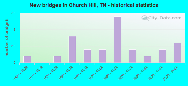
- New bridges - historical statistics
- 11900-1909
- 11920-1929
- 41930-1939
- 21940-1949
- 21950-1959
- 71960-1969
- 21970-1979
- 11980-1989
- 21990-1999
- 32000-2009
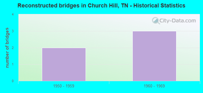
- Reconstructed bridges - Historical Statistics
- 21950-1959
- 31960-1969
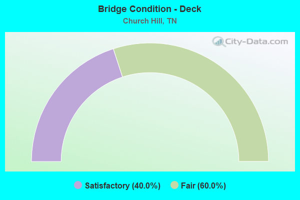
- Bridge Condition - Deck
- 40.0%Satisfactory
- 60.0%Fair
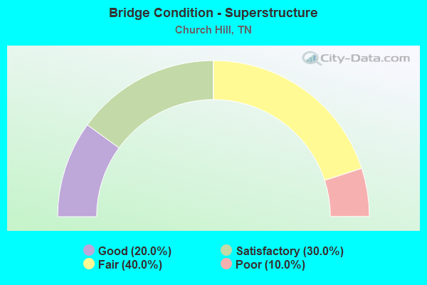
- Bridge Condition - Superstructure
- 20.0%Good
- 30.0%Satisfactory
- 40.0%Fair
- 10.0%Poor
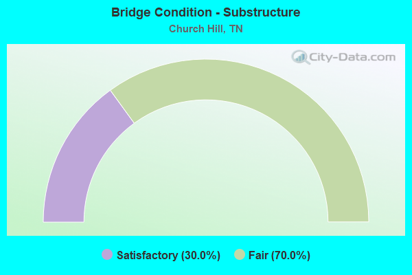
- Bridge Condition - Substructure
- 30.0%Satisfactory
- 70.0%Fair
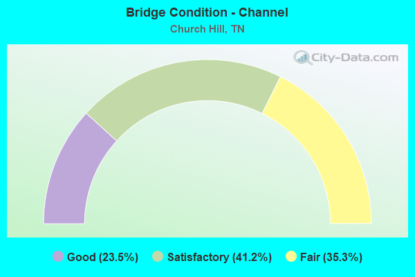
- Bridge Condition - Channel
- 23.5%Good
- 41.2%Satisfactory
- 35.3%Fair
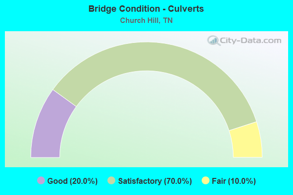
- Bridge Condition - Culverts
- 20.0%Good
- 70.0%Satisfactory
- 10.0%Fair
Find on map >> Show street view
Structure Number: 37005340009, Location: N. OF SR1-W. OF MT CARMEL (Lat: 36.521633, Lng: -82.715250), Route carried "on" structure: State highway 346, Year Built: 1960, Status: Open, Structure Length: 1.01m (3.31ft), Average Daily Traffic: 2,823 (year 2020), Truck Traffic: 4%, Average Future Daily Traffic: 4,944 (year 2040), Features Intersected: ALEXANDER CREEK
Minimum Vertical Clearance: 30+ m (98+ ft), Kilometerpoint: 12.891, Lanes on structure: 2, Owner: State Highway Agency, Approaching Roadway Width: 7.3m (24.0ft), Material/Design: Concrete continuous, Design/Construction: Slab, Number Of Spans In Main Unit: 2, Length of Maximum Span: 4.6m (15.1ft), Curb-To-Curb Width: 8.7m (28.5ft), Out-to-Out Width: 10.7m (35.1ft)
Condition: Deck: Fair, Superstructure: Fair, Substructure: Fair, Channel: Satisfactory, Operating Rating: 36.0 metric tons, Method Used To Determine Operating Rating: Field evaluation and documented engineering judgment, Inventory Rating: 24.3 metric tons, Method Used To Determine Inventory Rating: Field evaluation and documented engineering judgment, Structural Evaluation: Somewhat better than minimum adequacy, Deck Geometry: Meets minimum limits, Waterway Adequacy: Equal to present minimum criteria, Approach Roadway Alignment: Equal to present desirable criteria, Length Of Structure Improvement: 1.01m (3.31ft), Designated Inspection Frequency: Every 24 months, Inspection Date: September 2020, Bridge Improvement Cost: $75,000, Roadway Improvement Cost: $8,000, Total Project Cost: $113,000 ( Estimate for 2020), Deck Structure Type: Concrete Cast-file-Place, Wearing Surface/Protective System: Wearing Surface: Bituminous
Find on map >> Show street view
Structure Number: 37026040001, Location: 3 M SW OF CHURCH HILL (Lat: 36.484383, Lng: -82.753250), Route carried "on" structure: County highway 2604, Year Built: 1985, Status: Open, Structure Length: 1.01m (3.31ft), Average Daily Traffic: 681 (year 2020), Truck Traffic: 3%, Average Future Daily Traffic: 1,232 (year 2039), Features Intersected: HUNT CREEK
Minimum Vertical Clearance: 30+ m (98+ ft), Kilometerpoint: 3.283, Lanes on structure: 2, Owner: County Highway Agency, Approaching Roadway Width: 7.3m (24.0ft), Material/Design: Concrete, Design/Construction: Culvert, Number Of Spans In Main Unit: 1, Length of Maximum Span: 4.6m (15.1ft)
Condition: Channel: Fair, Culverts: Satisfactory, Operating Rating: 58.5 metric tons, Method Used To Determine Operating Rating: Load Factor (LF), Inventory Rating: 32.4 metric tons, Method Used To Determine Inventory Rating: Load Factor (LF), Structural Evaluation: Equal to present minimum criteria, Waterway Adequacy: Equal to present minimum criteria, Approach Roadway Alignment: Equal to present desirable criteria, Designated Inspection Frequency: Every 24 months, Inspection Date: July 2021
Find on map >> Show street view
Structure Number: 370A2360001, Location: NW OF SR346 AT CHURCH HIL (Lat: 36.564433, Lng: -82.728700), Route carried "on" structure: County highway 236, Year Built: 2009, Status: Open, Structure Length: 2.05m (6.73ft), Average Daily Traffic: 1,030 (year 2022), Truck Traffic: 2%, Average Future Daily Traffic: 1,648 (year 2039), Design Load: HS 20, Features Intersected: ALEXANDER CREEK
Minimum Vertical Clearance: 30+ m (98+ ft), Kilometerpoint: 0.589, Lanes on structure: 2, Owner: County Highway Agency, Approaching Roadway Width: 7.5m (24.6ft), Skew: 4 degrees, Material/Design: Concrete continuous, Design/Construction: Culvert, Number Of Spans In Main Unit: 3, Length of Maximum Span: 3.7m (12.1ft), Curb-To-Curb Width: 8.6m (28.2ft), Out-to-Out Width: 12.2m (40.0ft)
Condition: Channel: Fair, Culverts: Good, Operating Rating: 44.1 metric tons, Method Used To Determine Operating Rating: Allowable Stress (AS), Inventory Rating: 32.4 metric tons, Method Used To Determine Inventory Rating: Allowable Stress (AS), Structural Evaluation: Better than present minimum criteria, Deck Geometry: Somewhat better than minimum adequacy, Waterway Adequacy: Equal to present minimum criteria, Approach Roadway Alignment: Equal to present minimum criteria, Designated Inspection Frequency: Every 24 months, Inspection Date: June 2021, Deck Structure Type: Concrete Cast-file-Place, Wearing Surface/Protective System: Wearing Surface: Integral Concrete
Find on map >> Show street view
Structure Number: 370A3520001, Location: .5 M SE OF US11W-SR346 JC (Lat: 36.501733, Lng: -82.788117), Route carried "on" structure: County highway 352, Year Built: 1959, Status: Open, Structure Length: 4.42m (14.50ft), Average Daily Traffic: 2,300 (year 2022), Truck Traffic: 2%, Average Future Daily Traffic: 3,680 (year 2040), Design Load: H 20, Features Intersected: SOUTHERN RAILWAY
Minimum Vertical Clearance: 30+ m (98+ ft), Kilometerpoint: 0.719, Lanes on structure: 2, Owner: County Highway Agency, Approaching Roadway Width: 8.8m (28.9ft), Skew: 3 degrees, Material/Design: Concrete continuous, Design/Construction: Tee Beam, Number Of Spans In Main Unit: 3, Length of Maximum Span: 18.9m (62.0ft), Curb-To-Curb Width: 8.5m (27.9ft), Out-to-Out Width: 10.5m (34.4ft)
Condition: Deck: Fair, Superstructure: Fair, Substructure: Fair, Operating Rating: 33.0 metric tons, Method Used To Determine Operating Rating: Load and Resistance Factor Rating (LRFR) rating reported by rating factor(RF) method using HL-93 loadings, Inventory Rating: 25.6 metric tons, Method Used To Determine Inventory Rating: Load and Resistance Factor Rating (LRFR) rating reported by rating factor(RF) method using HL-93 loadings, Structural Evaluation: Somewhat better than minimum adequacy, Deck Geometry: Meets minimum limits, Underclear: Superior to present desirable criteria, Approach Roadway Alignment: Equal to present minimum criteria, Length Of Structure Improvement: 5.41m (17.75ft), Designated Inspection Frequency: Every 24 months, Inspection Date: July 2021, Bridge Improvement Cost: $1,446,000, Roadway Improvement Cost: $145,000, Total Project Cost: $2,170,000 ( Estimate for 2020), Deck Structure Type: Concrete Cast-file-Place, Wearing Surface/Protective System: Wearing Surface: Monolithic Concrete
Find on map >> Show street view
Structure Number: 370A3530001, Location: .4 M SE OF US11W-SR346 JC (Lat: 36.500933, Lng: -82.790250), Route carried "on" structure: County highway 353, Year Built: 1960, Status: Open, Structure Length: 4.08m (13.39ft), Average Daily Traffic: 210 (year 2022), Truck Traffic: 2%, Average Future Daily Traffic: 336 (year 2039), Design Load: H 15, Features Intersected: SOUTHERN RAILWAY
Minimum Vertical Clearance: 30+ m (98+ ft), Kilometerpoint: 0.174, Lanes on structure: 2, Owner: County Highway Agency, Approaching Roadway Width: 6.7m (22.0ft), Material/Design: Concrete continuous, Design/Construction: Tee Beam, Number Of Spans In Main Unit: 3, Length of Maximum Span: 15.8m (51.8ft), Curb-To-Curb Width: 7.3m (24.0ft), Out-to-Out Width: 8.7m (28.5ft)
Condition: Deck: Satisfactory, Superstructure: Satisfactory, Substructure: Satisfactory, Operating Rating: 31.5 metric tons, Method Used To Determine Operating Rating: Load Factor (LF), Inventory Rating: 18.9 metric tons, Method Used To Determine Inventory Rating: Load Factor (LF), Structural Evaluation: Somewhat better than minimum adequacy, Deck Geometry: Somewhat better than minimum adequacy, Underclear: Better than present minimum criteria, Approach Roadway Alignment: Equal to present minimum criteria, Length Of Structure Improvement: 4.08m (13.39ft), Designated Inspection Frequency: Every 24 months, Inspection Date: July 2021, Bridge Improvement Cost: $602,000, Roadway Improvement Cost: $61,000, Total Project Cost: $904,000 ( Estimate for 2019), Deck Structure Type: Concrete Cast-file-Place, Wearing Surface/Protective System: Wearing Surface: Monolithic Concrete
Find on map >> Show street view
Structure Number: 370A3550001, Location: .5 M E OF US11W-SR346 JCT (Lat: 36.505483, Lng: -82.789417), Route carried "on" structure: City street 355, Year Built: 1925, Year Reconstructed: 1950, Status: Open, Structure Length: 1.19m (3.90ft), Average Daily Traffic: 80 (year 2022), Truck Traffic: 2%, Average Future Daily Traffic: 128 (year 2039), Features Intersected: BRADLEY CREEK
Minimum Vertical Clearance: 30+ m (98+ ft), Kilometerpoint: 0.286, Lanes on structure: 2, Owner: City or Municipal Highway Agency, Approaching Roadway Width: 9.1m (29.9ft), Material/Design: Concrete, Design/Construction: Arch - Deck, Number Of Spans In Main Unit: 1, Length of Maximum Span: 7.3m (24.0ft), Curb-To-Curb Width: 8.6m (28.2ft), Out-to-Out Width: 10.5m (34.4ft)
Condition: Deck: Satisfactory, Superstructure: Satisfactory, Substructure: Fair, Channel: Satisfactory, Operating Rating: 36.0 metric tons, Method Used To Determine Operating Rating: Field evaluation and documented engineering judgment, Inventory Rating: 24.3 metric tons, Method Used To Determine Inventory Rating: Field evaluation and documented engineering judgment, Structural Evaluation: Somewhat better than minimum adequacy, Deck Geometry: Better than present minimum criteria, Waterway Adequacy: Somewhat better than minimum adequacy, Approach Roadway Alignment: Equal to present desirable criteria, Length Of Structure Improvement: 1.19m (3.90ft), Designated Inspection Frequency: Every 24 months, Inspection Date: July 2021, Bridge Improvement Cost: $206,000, Roadway Improvement Cost: $21,000, Total Project Cost: $310,000 ( Estimate for 2019), Wearing Surface/Protective System: Wearing Surface: Bituminous
Find on map >> Show street view
Structure Number: 370A3550003, Location: 1 M E OF US11W-SR346 JCT. (Lat: 36.508133, Lng: -82.781817), Route carried "on" structure: City street 355, Year Built: 1930, Year Reconstructed: 1955, Status: Open, Structure Length: 1.74m (5.71ft), Average Daily Traffic: 80 (year 2022), Truck Traffic: 2%, Average Future Daily Traffic: 128 (year 2039), Design Load: H 20, Features Intersected: RENFROE CREEK
Minimum Vertical Clearance: 30+ m (98+ ft), Kilometerpoint: 1.038, Lanes on structure: 2, Owner: City or Municipal Highway Agency, Approaching Roadway Width: 9.4m (30.8ft), Skew: 4 degrees, Material/Design: Concrete, Design/Construction: Slab, Number Of Spans In Main Unit: 2, Length of Maximum Span: 5.8m (19.0ft), Curb-To-Curb Width: 8.6m (28.2ft), Out-to-Out Width: 10.5m (34.4ft)
Condition: Deck: Fair, Superstructure: Fair, Substructure: Fair, Channel: Satisfactory, Operating Rating: 36.0 metric tons, Method Used To Determine Operating Rating: Field evaluation and documented engineering judgment, Inventory Rating: 24.3 metric tons, Method Used To Determine Inventory Rating: Field evaluation and documented engineering judgment, Structural Evaluation: Somewhat better than minimum adequacy, Deck Geometry: Better than present minimum criteria, Waterway Adequacy: Equal to present minimum criteria, Approach Roadway Alignment: Equal to present minimum criteria, Length Of Structure Improvement: 1.74m (5.71ft), Designated Inspection Frequency: Every 24 months, Inspection Date: July 2021, Bridge Improvement Cost: $283,000, Roadway Improvement Cost: $29,000, Total Project Cost: $425,000 ( Estimate for 2019), Deck Structure Type: Concrete Cast-file-Place, Wearing Surface/Protective System: Wearing Surface: Bituminous
Find on map >> Show street view
Structure Number: 370A3550005, Location: 3.5 M W OF CHURCH HILL (Lat: 36.517933, Lng: -82.781817), Route carried "on" structure: County highway 355, Year Built: 1930, Year Reconstructed: 1973, Status: Open, Structure Length: 0.82m (2.69ft), Average Daily Traffic: 80 (year 2022), Truck Traffic: 2%, Average Future Daily Traffic: 128 (year 2039), Design Load: H 15, Features Intersected: RENFROE CREEK
Minimum Vertical Clearance: 30+ m (98+ ft), Kilometerpoint: 2.205, Lanes on structure: 2, Owner: County Highway Agency, Approaching Roadway Width: 4.6m (15.1ft), Skew: 3 degrees, Material/Design: Concrete, Design/Construction: Slab, Number Of Spans In Main Unit: 1, Length of Maximum Span: 7.3m (24.0ft), Curb-To-Curb Width: 5.5m (18.0ft), Out-to-Out Width: 5.9m (19.4ft)
Condition: Deck: Satisfactory, Superstructure: Good, Substructure: Fair, Channel: Good, Operating Rating: 36.0 metric tons, Method Used To Determine Operating Rating: Field evaluation and documented engineering judgment, Inventory Rating: 24.3 metric tons, Method Used To Determine Inventory Rating: Field evaluation and documented engineering judgment, Structural Evaluation: Somewhat better than minimum adequacy, Deck Geometry: Meets minimum limits, Waterway Adequacy: Equal to present minimum criteria, Approach Roadway Alignment: Equal to present minimum criteria, Length Of Structure Improvement: 0.82m (2.69ft), Designated Inspection Frequency: Every 24 months, Inspection Date: June 2021, Bridge Improvement Cost: $64,000, Roadway Improvement Cost: $7,000, Total Project Cost: $97,000 ( Estimate for 2019), Deck Structure Type: Concrete Cast-file-Place, Wearing Surface/Protective System: Wearing Surface: Bituminous
Find on map >> Show street view
Structure Number: 370A3560001, Location: 3.5 M SW OF CHURCH HILL (Lat: 36.507283, Lng: -82.781617), Route carried "on" structure: City street 356, Year Built: 1940, Year Reconstructed: 1973, Status: Open, Structure Length: 0.67m (2.20ft), Average Daily Traffic: 80 (year 2022), Truck Traffic: 2%, Average Future Daily Traffic: 128 (year 2039), Design Load: H 15, Features Intersected: RENFROE CREEK
Minimum Vertical Clearance: 30+ m (98+ ft), Kilometerpoint: 0.087, Lanes on structure: 1, Owner: City or Municipal Highway Agency, Approaching Roadway Width: 4.0m (13.1ft), Skew: 1 degrees, Material/Design: Concrete, Design/Construction: Slab, Number Of Spans In Main Unit: 1, Length of Maximum Span: 6.1m (20.0ft), Curb-To-Curb Width: 4.3m (14.1ft), Out-to-Out Width: 4.7m (15.4ft)
Condition: Deck: Fair, Superstructure: Fair, Substructure: Satisfactory, Channel: Satisfactory, Operating Rating: 41.4 metric tons, Method Used To Determine Operating Rating: Load Factor (LF), Inventory Rating: 25.2 metric tons, Method Used To Determine Inventory Rating: Load Factor (LF), Structural Evaluation: Somewhat better than minimum adequacy, Deck Geometry: Equal to present minimum criteria, Waterway Adequacy: Somewhat better than minimum adequacy, Approach Roadway Alignment: Equal to present minimum criteria, Length Of Structure Improvement: 0.67m (2.20ft), Designated Inspection Frequency: Every 24 months, Inspection Date: July 2021, Bridge Improvement Cost: $104,000, Roadway Improvement Cost: $11,000, Total Project Cost: $157,000 ( Estimate for 2019), Deck Structure Type: Concrete Cast-file-Place, Wearing Surface/Protective System: Wearing Surface: Monolithic Concrete
Find on map >> Show street view
Structure Number: 370A3580001, Location: 3.5 M W OF CHURCH HILL (Lat: 36.518000, Lng: -82.782517), Route carried "on" structure: County highway 358, Year Built: 1930, Year Reconstructed: 1973, Status: Open, Structure Length: 0.64m (2.10ft), Average Daily Traffic: 190 (year 2022), Truck Traffic: 2%, Average Future Daily Traffic: 304 (year 2039), Design Load: H 15, Features Intersected: RENFROE CREEK
Minimum Vertical Clearance: 30+ m (98+ ft), Kilometerpoint: 1.239, Lanes on structure: 2, Owner: County Highway Agency, Approaching Roadway Width: 5.5m (18.0ft), Material/Design: Concrete, Design/Construction: Slab, Number Of Spans In Main Unit: 1, Length of Maximum Span: 5.5m (18.0ft), Curb-To-Curb Width: 5.5m (18.0ft), Out-to-Out Width: 5.9m (19.4ft)
Condition: Deck: Satisfactory, Superstructure: Satisfactory, Substructure: Fair, Channel: Good, Operating Rating: 36.0 metric tons, Method Used To Determine Operating Rating: Field evaluation and documented engineering judgment, Inventory Rating: 24.3 metric tons, Method Used To Determine Inventory Rating: Field evaluation and documented engineering judgment, Structural Evaluation: Somewhat better than minimum adequacy, Deck Geometry: High priority of corrective action, Waterway Adequacy: Equal to present minimum criteria, Approach Roadway Alignment: Equal to present minimum criteria, Length Of Structure Improvement: 0.64m (2.10ft), Designated Inspection Frequency: Every 24 months, Inspection Date: June 2021, Bridge Improvement Cost: $71,000, Roadway Improvement Cost: $8,000, Total Project Cost: $107,000 ( Estimate for 2019), Deck Structure Type: Concrete Cast-file-Place, Wearing Surface/Protective System: Wearing Surface: Bituminous
Find on map >> Show street view
Structure Number: 370A3590001, Location: 3 M SW OF CHURCH HILL (Lat: 36.504733, Lng: -82.770550), Route carried "on" structure: City street 5322, Year Built: 1962, Status: Open, Structure Length: 4.85m (15.91ft), Average Daily Traffic: 1,357 (year 2020), Truck Traffic: 3%, Average Future Daily Traffic: 2,928 (year 2039), Design Load: HS 20, Features Intersected: NORFOLK / SOU RAILWAY, Facility Carried by Structure: NFA A359 730175T
Minimum Vertical Clearance: 30+ m (98+ ft), Kilometerpoint: 0.853, Lanes on structure: 2, Owner: City or Municipal Highway Agency, Approaching Roadway Width: 7.3m (24.0ft), Material/Design: Prestressed concrete, Design/Construction: Stringer/Multi-beam, Number Of Spans In Main Unit: 3, Length of Maximum Span: 16.5m (54.1ft), Curb-To-Curb Width: 8.5m (27.9ft), Out-to-Out Width: 10.5m (34.4ft)
Condition: Deck: Fair, Superstructure: Good, Substructure: Satisfactory, Operating Rating: 46.8 metric tons, Method Used To Determine Operating Rating: Load Factor (LF), Inventory Rating: 29.7 metric tons, Method Used To Determine Inventory Rating: Load Factor (LF), Structural Evaluation: Equal to present minimum criteria, Deck Geometry: Somewhat better than minimum adequacy, Underclear: Better than present minimum criteria, Approach Roadway Alignment: Equal to present desirable criteria, Length Of Structure Improvement: 4.85m (15.91ft), Designated Inspection Frequency: Every 24 months, Inspection Date: July 2021, Bridge Improvement Cost: $124,000, Roadway Improvement Cost: $13,000, Total Project Cost: $187,000 ( Estimate for 2019), Deck Structure Type: Concrete Cast-file-Place, Wearing Surface/Protective System: Wearing Surface: Monolithic Concrete
Find on map >> Show street view
Structure Number: 370A3830001, Location: N. OF CHURCH HILL (Lat: 36.535117, Lng: -82.720767), Route carried "on" structure: County highway 383, Year Built: 2003, Status: Open, Structure Length: 1.49m (4.89ft), Average Daily Traffic: 50 (year 2022), Truck Traffic: 5%, Average Future Daily Traffic: 80 (year 2039), Features Intersected: ALEXANDER CREEK
Minimum Vertical Clearance: 30+ m (98+ ft), Kilometerpoint: 5.391, Lanes on structure: 2, Owner: County Highway Agency, Approaching Roadway Width: 7.2m (23.6ft), Skew: 2 degrees, Material/Design: Concrete continuous, Design/Construction: Culvert, Number Of Spans In Main Unit: 3, Length of Maximum Span: 4.5m (14.8ft)
Condition: Channel: Good, Culverts: Good, Operating Rating: 44.1 metric tons, Method Used To Determine Operating Rating: Load Factor (LF), Inventory Rating: 32.4 metric tons, Method Used To Determine Inventory Rating: Load Factor (LF), Structural Evaluation: Better than present minimum criteria, Waterway Adequacy: Better than present minimum criteria, Approach Roadway Alignment: Equal to present minimum criteria, Designated Inspection Frequency: Every 24 months, Inspection Date: June 2021, Deck Structure Type: Concrete Cast-file-Place, Wearing Surface/Protective System: Wearing Surface: Bituminous, Deck Protection: Epoxy Coated Reinforcing
Find on map >> Show street view
Structure Number: 370A4300001, Location: IN CHURCH HILL (Lat: 36.524850, Lng: -82.715917), Route carried "on" structure: City street 430, Year Built: 1993, Status: Open, Structure Length: 0.98m (3.22ft), Average Daily Traffic: 220 (year 2022), Truck Traffic: 2%, Average Future Daily Traffic: 352 (year 2039), Design Load: HS 20, Features Intersected: ALEXANDER CREEK
Minimum Vertical Clearance: 30+ m (98+ ft), Kilometerpoint: 0.061, Lanes on structure: 2, Owner: City or Municipal Highway Agency, Approaching Roadway Width: 6.1m (20.0ft), Skew: 1 degrees, Material/Design: Concrete continuous, Design/Construction: Culvert, Number Of Spans In Main Unit: 2, Length of Maximum Span: 4.9m (16.1ft), Curb-To-Curb Width: 6.5m (21.3ft), Out-to-Out Width: 8.4m (27.6ft)
Condition: Channel: Good, Culverts: Satisfactory, Operating Rating: 44.1 metric tons, Method Used To Determine Operating Rating: Load Factor (LF), Inventory Rating: 26.1 metric tons, Method Used To Determine Inventory Rating: Load Factor (LF), Structural Evaluation: Equal to present minimum criteria, Deck Geometry: Meets minimum limits, Waterway Adequacy: Equal to present minimum criteria, Approach Roadway Alignment: Equal to present desirable criteria, Length Of Structure Improvement: 0.98m (3.22ft), Designated Inspection Frequency: Every 24 months, Inspection Date: June 2021, Bridge Improvement Cost: $42,000, Roadway Improvement Cost: $5,000, Total Project Cost: $64,000 ( Estimate for 2019), Deck Structure Type: Concrete Cast-file-Place, Wearing Surface/Protective System: Wearing Surface: Monolithic Concrete, Deck Protection: Epoxy Coated Reinforcing
Find on map >> Show street view
Structure Number: 370A6380001, Location: 2 M S OF US 11W @ CHURCH (Lat: 36.489833, Lng: -82.721450), Route carried "on" structure: County highway 638, Year Built: 1995, Status: Open, Structure Length: 0.94m (3.08ft), Average Daily Traffic: 1,300 (year 2022), Truck Traffic: 2%, Average Future Daily Traffic: 2,080 (year 2039), Design Load: HS 20, Features Intersected: GOSHEN CREEK
Minimum Vertical Clearance: 30+ m (98+ ft), Kilometerpoint: 0.008, Lanes on structure: 2, Owner: County Highway Agency, Approaching Roadway Width: 7.9m (25.9ft), Skew: 4 degrees, Material/Design: Concrete continuous, Design/Construction: Culvert, Number Of Spans In Main Unit: 2, Length of Maximum Span: 3.0m (9.8ft), Curb-To-Curb Width: 7.9m (25.9ft), Out-to-Out Width: 9.7m (31.8ft)
Condition: Channel: Satisfactory, Culverts: Satisfactory, Operating Rating: 71.1 metric tons, Method Used To Determine Operating Rating: Load Factor (LF), Inventory Rating: 32.4 metric tons, Method Used To Determine Inventory Rating: Load Factor (LF), Structural Evaluation: Equal to present minimum criteria, Deck Geometry: Meets minimum limits, Waterway Adequacy: Better than present minimum criteria, Approach Roadway Alignment: Equal to present minimum criteria, Designated Inspection Frequency: Every 24 months, Inspection Date: July 2021, Deck Structure Type: Concrete Cast-file-Place, Wearing Surface/Protective System: Wearing Surface: Monolithic Concrete, Deck Protection: Epoxy Coated Reinforcing
Find on map >> Show street view
Structure Number: 37M39500003, Location: IN CHURCH HILL (Lat: 36.524600, Lng: -82.700133), Route carried "on" structure: City street 3950, Year Built: 1952, Status: Open, Structure Length: 0.70m (2.30ft), Average Daily Traffic: 2,074 (year 2020), Truck Traffic: 4%, Average Future Daily Traffic: 3,664 (year 2039), Design Load: H 15, Features Intersected: SMITH CREEK
Minimum Vertical Clearance: 30+ m (98+ ft), Kilometerpoint: 5.311, Lanes on structure: 2, Owner: City or Municipal Highway Agency, Approaching Roadway Width: 7.0m (23.0ft), Skew: 4 degrees, Material/Design: Concrete continuous, Design/Construction: Culvert, Number Of Spans In Main Unit: 2, Length of Maximum Span: 2.4m (7.9ft)
Condition: Channel: Fair, Culverts: Satisfactory, Operating Rating: 45.0 metric tons, Method Used To Determine Operating Rating: Load Factor (LF), Inventory Rating: 25.2 metric tons, Method Used To Determine Inventory Rating: Load Factor (LF), Structural Evaluation: Equal to present minimum criteria, Waterway Adequacy: Meets minimum limits, Approach Roadway Alignment: Equal to present desirable criteria, Designated Inspection Frequency: Every 24 months, Inspection Date: June 2021
Find on map >> Show street view
Structure Number: 37S23670007, Location: JUST S OF SR346-US11W JCT (Lat: 36.515583, Lng: -82.724167), Route carried "on" structure: County highway 1175, Year Built: 1964, Status: Posted for load, Structure Length: 26.64m (87.40ft), Average Daily Traffic: 4,277 (year 2020), Truck Traffic: 3%, Average Future Daily Traffic: 6,843 (year 2041), Design Load: H 15, Features Intersected: HOLSTON RIVER
Minimum Vertical Clearance: 30+ m (98+ ft), Kilometerpoint: 20.246, Lanes on structure: 2, Owner: County Highway Agency, Approaching Roadway Width: 8.5m (27.9ft), Material/Design: Steel, Design/Construction: Stringer/Multi-beam, Number Of Spans In Main Unit: 1, Number Of Approach Spans: 7, Length of Maximum Span: 64.0m (210.0ft), Curb-To-Curb Width: 7.3m (24.0ft), Out-to-Out Width: 8.7m (28.5ft)
Condition: Deck: Fair, Superstructure: Poor, Substructure: Fair, Channel: Fair, Operating Rating: 12.3 metric tons, Method Used To Determine Operating Rating: Load and Resistance Factor Rating (LRFR) rating reported by rating factor(RF) method using HL-93 loadings, Inventory Rating: 9.4 metric tons, Method Used To Determine Inventory Rating: Load and Resistance Factor Rating (LRFR) rating reported by rating factor(RF) method using HL-93 loadings, Structural Evaluation: High priority of replacement, Deck Geometry: High priority of replacement, Waterway Adequacy: Better than present minimum criteria, Approach Roadway Alignment: Equal to present desirable criteria, Bridge Posting: Required (Relationship of Operating Rating to Maximum Legal Load: 0.1 - 9.9% below), Length Of Structure Improvement: 26.64m (87.40ft), Designated Inspection Frequency: Every 24 months, Critical Feature Inspection Frequency: Every 24 months, Underwater Inspection Frequency: Every 60 months, Inspection Date: May 2021, Critical Feature Inspection Date: May 2021, Underwater Inspection Date: August 2021, Bridge Improvement Cost: $9,563,000, Roadway Improvement Cost: $957,000, Total Project Cost: $14,345,000 ( Estimate for 2021), Deck Structure Type: Concrete Cast-file-Place, Wearing Surface/Protective System: Wearing Surface: Monolithic Concrete
Find on map >> Show street view
Structure Number: 37SR0010021, Location: E. OF SURGOINSVILLE (Lat: 36.509017, Lng: -82.782117), Route carried "on" structure: US 11, Year Built: 1975, Status: Open, Structure Length: 0.98m (3.22ft), Average Daily Traffic: 13,273 (year 2020), Truck Traffic: 9%, Average Future Daily Traffic: 25,920 (year 2040), Design Load: HS 20, Features Intersected: RENFROE CREEK, Facility Carried by Structure: FAP 1
Minimum Vertical Clearance: 30+ m (98+ ft), Kilometerpoint: 50.212, Lanes on structure: 4, Base Highway Network: Yes, Owner: State Highway Agency, Approaching Roadway Width: 23.2m (76.1ft), Material/Design: Concrete continuous, Design/Construction: Culvert, Number Of Spans In Main Unit: 3, Length of Maximum Span: 3.0m (9.8ft)
Condition: Channel: Fair, Culverts: Satisfactory, Operating Rating: 89.1 metric tons, Method Used To Determine Operating Rating: Load Factor (LF), Inventory Rating: 32.4 metric tons, Method Used To Determine Inventory Rating: Load Factor (LF), Structural Evaluation: Equal to present minimum criteria, Waterway Adequacy: Better than present minimum criteria, Approach Roadway Alignment: Equal to present desirable criteria, Designated Inspection Frequency: Every 24 months, Inspection Date: August 2020
Find on map >> Show street view
Structure Number: 37SR0010023, Location: 3MI. E. OF CHURCH HILL (Lat: 36.506400, Lng: -82.791383), Route carried "on" structure: US 11, Year Built: 1975, Status: Open, Structure Length: 0.98m (3.22ft), Average Daily Traffic: 13,273 (year 2020), Truck Traffic: 9%, Average Future Daily Traffic: 25,920 (year 2040), Design Load: HS 20, Features Intersected: BRADLEY CREEK, Facility Carried by Structure: FAP 1
Minimum Vertical Clearance: 30+ m (98+ ft), Kilometerpoint: 48.570, Lanes on structure: 5, Base Highway Network: Yes, Owner: State Highway Agency, Approaching Roadway Width: 29.0m (95.1ft), Skew: 10 degrees, Material/Design: Concrete continuous, Design/Construction: Culvert, Number Of Spans In Main Unit: 3, Length of Maximum Span: 3.4m (11.2ft)
Condition: Channel: Satisfactory, Culverts: Satisfactory, Operating Rating: 89.1 metric tons, Method Used To Determine Operating Rating: Load Factor (LF), Inventory Rating: 32.4 metric tons, Method Used To Determine Inventory Rating: Load Factor (LF), Structural Evaluation: Equal to present minimum criteria, Waterway Adequacy: Better than present minimum criteria, Approach Roadway Alignment: Equal to present desirable criteria, Designated Inspection Frequency: Every 24 months, Inspection Date: August 2020
Find on map >> Show street view
Structure Number: 37SR0010031, Location: IN CHURRCH HILL (Lat: 36.518250, Lng: -82.717817), Route carried "on" structure: US 11, Year Built: 1968, Status: Open, Structure Length: 0.70m (2.30ft), Average Daily Traffic: 18,341 (year 2020), Truck Traffic: 11%, Average Future Daily Traffic: 32,384 (year 2040), Design Load: HS 20, Features Intersected: ALEXANDER CREEK, Facility Carried by Structure: FAP 1
Minimum Vertical Clearance: 30+ m (98+ ft), Kilometerpoint: 56.231, Lanes on structure: 4, Base Highway Network: Yes, Owner: State Highway Agency, Approaching Roadway Width: 23.2m (76.1ft), Skew: 24 degrees, Material/Design: Concrete, Design/Construction: Culvert, Number Of Spans In Main Unit: 1, Length of Maximum Span: 6.4m (21.0ft)
Condition: Channel: Satisfactory, Culverts: Fair, Operating Rating: 54.0 metric tons, Method Used To Determine Operating Rating: Field evaluation and documented engineering judgment, Inventory Rating: 32.4 metric tons, Method Used To Determine Inventory Rating: Field evaluation and documented engineering judgment, Structural Evaluation: Somewhat better than minimum adequacy, Waterway Adequacy: Equal to present minimum criteria, Approach Roadway Alignment: Equal to present desirable criteria, Length Of Structure Improvement: 0.70m (2.30ft), Designated Inspection Frequency: Every 24 months, Inspection Date: August 2020, Bridge Improvement Cost: $240,000, Roadway Improvement Cost: $25,000, Total Project Cost: $361,000 ( Estimate for 2020)
Find on map >> Show street view
Structure Number: 37SR0010033, Location: 1.2 M WOLF CHURCH HILL (Lat: 36.521050, Lng: -82.697983), Route carried "on" structure: US 11, Year Built: 1968, Status: Open, Structure Length: 0.64m (2.10ft), Average Daily Traffic: 18,341 (year 2020), Truck Traffic: 11%, Average Future Daily Traffic: 32,384 (year 2040), Design Load: HS 20, Features Intersected: SMITH CREEK, Facility Carried by Structure: FAP 1
Minimum Vertical Clearance: 30+ m (98+ ft), Kilometerpoint: 58.098, Lanes on structure: 4, Base Highway Network: Yes, Owner: State Highway Agency, Approaching Roadway Width: 23.8m (78.1ft), Skew: 21 degrees, Material/Design: Concrete continuous, Design/Construction: Culvert, Number Of Spans In Main Unit: 2, Length of Maximum Span: 3.0m (9.8ft)
Condition: Channel: Fair, Culverts: Satisfactory, Operating Rating: 71.1 metric tons, Method Used To Determine Operating Rating: Load Factor (LF), Inventory Rating: 32.4 metric tons, Method Used To Determine Inventory Rating: Load Factor (LF), Structural Evaluation: Equal to present minimum criteria, Waterway Adequacy: Equal to present minimum criteria, Approach Roadway Alignment: Equal to present desirable criteria, Length Of Structure Improvement: 0.64m (2.10ft), Designated Inspection Frequency: Every 24 months, Inspection Date: August 2020, Bridge Improvement Cost: $217,000, Roadway Improvement Cost: $22,000, Total Project Cost: $326,000 ( Estimate for 2020)
Find on map >> Show street view
Structure Number: 37039510001, Location: IN CHURCH HILL (Lat: 36.521250, Lng: -82.718783), Route carried "under" structure: City street 3951, Year Built: 1930, Structure Length: 0. m, Average Daily Traffic: 1,144 (year 2020), Truck Traffic: 3%, Features Intersected: SOUTHERN RAILWAY, Facility Carried by Structure: SOU RWY 730169P
Minimum Vertical Clearance: 3.99m (13.09ft), Kilometerpoint: 2.430, Lanes under structure: 2, Material/Design: Concrete, Design/Construction: Slab, Length of Maximum Span: 4.6m (15.1ft)
Find on map >> Show street view
Structure Number: 370A3540001, Location: S OF US11W-E OF SURGOINSV (Lat: 36.501967, Lng: -82.785467), Route carried "under" structure: County highway 354, Year Built: 1940, Structure Length: 0. m, Average Daily Traffic: 20 (year 2022), Truck Traffic: 2%, Features Intersected: SOUTHERN RAILWAY, Facility Carried by Structure: SOU RWY 730176A
Minimum Vertical Clearance: 4.04m (13.25ft), Kilometerpoint: 0.217, Lanes under structure: 1, Material/Design: Steel continuous, Design/Construction: Stringer/Multi-beam, Length of Maximum Span: 4.0m (13.1ft)
Find on map >> Show street view
Structure Number: 370A4610001, Location: OLD STAGE RD. (Lat: 36.525433, Lng: -82.701567), Route carried "under" structure: City street 4774, Year Built: 1905, Structure Length: 0. m, Average Daily Traffic: 929 (year 2020), Truck Traffic: 4%, Features Intersected: SOUTHERN RAILWAY, Facility Carried by Structure: SOU RWY 730165M
Minimum Vertical Clearance: 2.57m (8.43ft), Kilometerpoint: 4.506, Lanes under structure: 2, Material/Design: Concrete, Design/Construction: Culvert, Length of Maximum Span: 7.3m (24.0ft)
Find on map >> Show street view
Structure Number: 37SR0010029, Location: NEAR SURGOINSVILLE TENN. (Lat: 36.519200, Lng: -82.722650), Route carried "under" structure: US 11, Year Built: 1968, Structure Length: 0. m, Average Daily Traffic: 15,194 (year 2020), Truck Traffic: 9%, Features Intersected: SOUTHERN RAILWAY, Facility Carried by Structure: SOU RWY 730170J
Minimum Vertical Clearance: 4.72m (15.49ft), Kilometerpoint: 55.796, Lanes under structure: 4, Material/Design: Steel continuous, Design/Construction: Stringer/Multi-beam, Length of Maximum Span: 33.5m (109.9ft)
Find on map >> Show street view
Structure Number: 37SR3460001, Location: 3 M S OF CHURCH HILL (Lat: 36.523267, Lng: -82.713767), Route carried "under" structure: State highway 346, Year Built: 2004, Structure Length: 0. m, Average Daily Traffic: 2,578 (year 2020), Truck Traffic: 4%, Features Intersected: SOUTHERN RAILWAY, Facility Carried by Structure: SOU RWY 730167B
Minimum Vertical Clearance: 4.95m (16.24ft), Kilometerpoint: 13.261, Lanes under structure: 3, Material/Design: Steel, Design/Construction: Stringer/Multi-beam, Length of Maximum Span: 46.6m (152.9ft)