Bridge Statistics for Clay City, Indiana (IN)
Condition, Traffic, Stress, Structural Evaluation, Project Costs
- National Bridge Inventory (NBI) Statistics
- 30Number of bridges
- 230ft / 70.2mTotal length
- $3,009,000Total costs
- 23,875Total average daily traffic
- 2,111Total average daily truck traffic
- 33,839Total future (year 2030) average daily traffic
- National Bridge Inventory (NBI) Registered Bridges for Clay City
- No street view available for this location
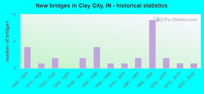
- New bridges - historical statistics
- 41900-1909
- 11910-1919
- 21920-1929
- 21940-1949
- 41950-1959
- 11960-1969
- 11970-1979
- 21980-1989
- 91990-1999
- 22000-2009
- 12010-2019
- 12020-2022

- Reconstructed bridges - Historical Statistics
- 31980-1989
- 21990-1999
- 12000-2009


- Bridge Condition - Deck
- 8.0%Good
- 64.0%Satisfactory
- 16.0%Fair
- 8.0%Poor
- 4.0%Imminent failure

- Bridge Condition - Superstructure
- 3.8%Very good
- 38.5%Good
- 42.3%Satisfactory
- 7.7%Fair
- 3.8%Poor
- 3.8%Imminent failure

- Bridge Condition - Substructure
- 57.7%Good
- 19.2%Satisfactory
- 11.5%Fair
- 7.7%Poor
- 3.8%Serious

- Bridge Condition - Channel
- 3.3%Excellent
- 10.0%Very good
- 40.0%Good
- 30.0%Satisfactory
- 13.3%Fair
- 3.3%Poor

- Bridge Condition - Culverts
- 25.0%Very good
- 50.0%Good
- 25.0%Fair
Find on map >> Show street view
Structure Number: 21225, Location: 2.56 S SR 246 (Lat: 39.226850, Lng: -87.116411), Route carried "on" structure: State highway 59, Year Built: 2018, Status: Open, Structure Length: 0.78m (2.56ft), Average Daily Traffic: 1,600 (year 2016), Truck Traffic: 6%, Average Future Daily Traffic: 1,820 (year 2036), Design Load: HL 93, Features Intersected: SUSAN BROTHERS CREEK
Minimum Vertical Clearance: 30+ m (98+ ft), Kilometerpoint: 28.194, Lanes on structure: 2, Owner: State Highway Agency, Approaching Roadway Width: 7.9m (25.9ft), Skew: 4 degrees, Material/Design: Concrete, Design/Construction: Culvert, Number Of Spans In Main Unit: 1, Length of Maximum Span: 6.9m (22.6ft), Curb-To-Curb Width: 7.9m (25.9ft), Out-to-Out Width: 7.9m (25.9ft)
Condition: Channel: Excellent, Culverts: Good, Operating Rating: 61.2 metric tons, Method Used To Determine Operating Rating: Load and Resistance Factor Rating (LRFR) rating reported by rating factor(RF) method using HL-93 loadings, Inventory Rating: 47.3 metric tons, Method Used To Determine Inventory Rating: Load and Resistance Factor Rating (LRFR) rating reported by rating factor(RF) method using HL-93 loadings, Structural Evaluation: Better than present minimum criteria, Deck Geometry: Meets minimum limits, Waterway Adequacy: Superior to present desirable criteria, Approach Roadway Alignment: Equal to present desirable criteria, Designated Inspection Frequency: Every 24 months, Inspection Date: November 2021
Find on map >> Show street view
Structure Number: 2123, Location: 00.40 N SR 246 (Lat: 39.286431, Lng: -87.112561), Route carried "on" structure: State highway 59, Year Built: 1954, Year Reconstructed: 1996, Status: Open, Structure Length: 0.98m (3.22ft), Average Daily Traffic: 5,613 (year 2004), Truck Traffic: 10%, Average Future Daily Traffic: 7,774 (year 2032), Design Load: HS 20, Features Intersected: BRANCH CONNELEY DITCH
Minimum Vertical Clearance: 30+ m (98+ ft), Kilometerpoint: 19.779, Lanes on structure: 2, Owner: State Highway Agency, Approaching Roadway Width: 9.1m (29.9ft), Skew: 3 degrees, Material/Design: Concrete, Design/Construction: Stringer/Multi-beam, Number Of Spans In Main Unit: 1, Length of Maximum Span: 9.1m (29.9ft), Curb-To-Curb Width: 11.7m (38.4ft), Out-to-Out Width: 12.5m (41.0ft)
Condition: Deck: Satisfactory, Superstructure: Good, Substructure: Satisfactory, Channel: Good, Operating Rating: 49.9 metric tons, Method Used To Determine Operating Rating: Load Factor (LF), Inventory Rating: 30.0 metric tons, Method Used To Determine Inventory Rating: Load Factor (LF), Structural Evaluation: Equal to present minimum criteria, Deck Geometry: Somewhat better than minimum adequacy, Waterway Adequacy: Superior to present desirable criteria, Approach Roadway Alignment: Equal to present desirable criteria, Designated Inspection Frequency: Every 24 months, Inspection Date: November 2021, Deck Structure Type: Concrete Cast-file-Place, Wearing Surface/Protective System: Wearing Surface: Latex Concrete
Find on map >> Show street view
Structure Number: 2124, Location: 01.56 N SR 246 (Lat: 39.302950, Lng: -87.110031), Route carried "on" structure: State highway 59, Year Built: 1954, Year Reconstructed: 1996, Status: Open, Structure Length: 0.91m (2.99ft), Average Daily Traffic: 4,274 (year 2004), Truck Traffic: 10%, Average Future Daily Traffic: 5,919 (year 2032), Design Load: HS 20, Features Intersected: MARKLEY DITCH
Minimum Vertical Clearance: 30+ m (98+ ft), Kilometerpoint: 21.646, Lanes on structure: 2, Owner: State Highway Agency, Approaching Roadway Width: 9.1m (29.9ft), Skew: 1 degrees, Material/Design: Concrete, Design/Construction: Stringer/Multi-beam, Number Of Spans In Main Unit: 1, Length of Maximum Span: 8.5m (27.9ft), Curb-To-Curb Width: 11.6m (38.1ft), Out-to-Out Width: 12.5m (41.0ft)
Condition: Deck: Satisfactory, Superstructure: Good, Substructure: Fair, Channel: Very good, Operating Rating: 55.8 metric tons, Method Used To Determine Operating Rating: Load Factor (LF), Inventory Rating: 33.5 metric tons, Method Used To Determine Inventory Rating: Load Factor (LF), Structural Evaluation: Somewhat better than minimum adequacy, Deck Geometry: Somewhat better than minimum adequacy, Waterway Adequacy: Superior to present desirable criteria, Approach Roadway Alignment: Equal to present desirable criteria, Designated Inspection Frequency: Every 24 months, Inspection Date: November 2021, Deck Structure Type: Concrete Cast-file-Place, Wearing Surface/Protective System: Wearing Surface: Latex Concrete
Find on map >> Show street view
Structure Number: 2125, Location: 02.11 N SR 246 (Lat: 39.310350, Lng: -87.109869), Route carried "on" structure: State highway 59, Year Built: 1955, Year Reconstructed: 1989, Status: Open, Structure Length: 17.86m (58.60ft), Average Daily Traffic: 4,274 (year 2004), Truck Traffic: 10%, Average Future Daily Traffic: 5,919 (year 2032), Design Load: HS 20, Features Intersected: CONNELEY DITCH
Minimum Vertical Clearance: 30+ m (98+ ft), Kilometerpoint: 22.531, Lanes on structure: 2, Owner: State Highway Agency, Approaching Roadway Width: 9.1m (29.9ft), Material/Design: Steel continuous, Design/Construction: Stringer/Multi-beam, Number Of Spans In Main Unit: 6, Length of Maximum Span: 31.7m (104.0ft), Curb-To-Curb Width: 8.9m (29.2ft), Out-to-Out Width: 9.8m (32.2ft)
Condition: Deck: Poor, Superstructure: Satisfactory, Substructure: Good, Channel: Satisfactory, Operating Rating: 30.5 metric tons, Method Used To Determine Operating Rating: Load and Resistance Factor Rating (LRFR) rating reported by rating factor(RF) method using HL-93 loadings, Inventory Rating: 23.7 metric tons, Method Used To Determine Inventory Rating: Load and Resistance Factor Rating (LRFR) rating reported by rating factor(RF) method using HL-93 loadings, Structural Evaluation: Equal to present minimum criteria, Deck Geometry: Meets minimum limits, Waterway Adequacy: Superior to present desirable criteria, Approach Roadway Alignment: Equal to present desirable criteria, Designated Inspection Frequency: Every 12 months, Inspection Date: October 2021, Deck Structure Type: Concrete Cast-file-Place, Wearing Surface/Protective System: Wearing Surface: Latex Concrete
Find on map >> Show street view
Structure Number: 2463, Location: 03.45 E SR 37 (Lat: 38.037161, Lng: -86.571011), Route carried "on" structure: State highway 70, Year Built: 1958, Status: Open, Structure Length: 1.01m (3.31ft), Average Daily Traffic: 836 (year 2004), Truck Traffic: 10%, Average Future Daily Traffic: 1,388 (year 2030), Design Load: HS 20, Features Intersected: BRANCH POISON CREEK
Minimum Vertical Clearance: 30+ m (98+ ft), Kilometerpoint: 5.552, Lanes on structure: 2, Owner: State Highway Agency, Approaching Roadway Width: 8.5m (27.9ft), Skew: 1 degrees, Material/Design: Concrete, Design/Construction: Culvert, Number Of Spans In Main Unit: 1, Length of Maximum Span: 9.1m (29.9ft)
Condition: Channel: Good, Culverts: Good, Operating Rating: 89.8 metric tons, Method Used To Determine Operating Rating: Load Factor (LF), Inventory Rating: 89.8 metric tons, Method Used To Determine Inventory Rating: Load Factor (LF), Structural Evaluation: Better than present minimum criteria, Waterway Adequacy: Superior to present desirable criteria, Approach Roadway Alignment: Equal to present desirable criteria, Designated Inspection Frequency: Every 24 months, Inspection Date: Febuary 2021, Wearing Surface/Protective System: Wearing Surface: Bituminous
Find on map >> Show street view
Structure Number: 2658, Location: 09.85 S SR 46 (Lat: 39.093511, Lng: -86.208131), Route carried "on" structure: State highway 135, Year Built: 1984, Status: Open, Structure Length: 3.81m (12.50ft), Average Daily Traffic: 174 (year 2004), Truck Traffic: 10%, Average Future Daily Traffic: 243 (year 2030), Design Load: HS 20, Features Intersected: MIDDLE FORK SALT CREEK
Minimum Vertical Clearance: 30+ m (98+ ft), Kilometerpoint: 9.431, Lanes on structure: 2, Owner: State Highway Agency, Approaching Roadway Width: 10.4m (34.1ft), Material/Design: Steel continuous, Design/Construction: Stringer/Multi-beam, Number Of Spans In Main Unit: 3, Length of Maximum Span: 14.3m (46.9ft), Curb-To-Curb Width: 10.4m (34.1ft), Out-to-Out Width: 11.2m (36.7ft)
Condition: Deck: Satisfactory, Superstructure: Satisfactory, Substructure: Good, Channel: Satisfactory, Operating Rating: 56.0 metric tons, Method Used To Determine Operating Rating: Load Factor (LF), Inventory Rating: 30.6 metric tons, Method Used To Determine Inventory Rating: Load Factor (LF), Structural Evaluation: Equal to present minimum criteria, Deck Geometry: Better than present minimum criteria, Waterway Adequacy: Somewhat better than minimum adequacy, Approach Roadway Alignment: Equal to present desirable criteria, Designated Inspection Frequency: Every 24 months, Inspection Date: December 2021, Deck Structure Type: Concrete Cast-file-Place, Wearing Surface/Protective System: Wearing Surface: Monolithic Concrete, Deck Protection: Epoxy Coated Reinforcing
Find on map >> Show street view
Structure Number: 2799, Location: 01.16 S SR 59 (Lat: 39.270350, Lng: -87.099019), Route carried "on" structure: State highway 157, Year Built: 1984, Status: Open, Structure Length: 0.73m (2.40ft), Average Daily Traffic: 1,776 (year 2004), Truck Traffic: 10%, Average Future Daily Traffic: 2,949 (year 2034), Features Intersected: BRANCH CONNELEY DITCH
Minimum Vertical Clearance: 30+ m (98+ ft), Kilometerpoint: 7.886, Lanes on structure: 2, Owner: State Highway Agency, Approaching Roadway Width: 13.4m (44.0ft), Skew: 5 degrees, Material/Design: Steel, Design/Construction: Culvert, Number Of Spans In Main Unit: 2, Length of Maximum Span: 3.1m (10.2ft)
Condition: Channel: Satisfactory, Culverts: Fair, Operating Rating: 97.2 metric tons, Method Used To Determine Operating Rating: Load and Resistance Factor Rating (LRFR) rating reported by rating factor(RF) method using HL-93 loadings, Inventory Rating: 82.9 metric tons, Method Used To Determine Inventory Rating: Load and Resistance Factor Rating (LRFR) rating reported by rating factor(RF) method using HL-93 loadings, Structural Evaluation: Somewhat better than minimum adequacy, Waterway Adequacy: Superior to present desirable criteria, Approach Roadway Alignment: Equal to present desirable criteria, Designated Inspection Frequency: Every 24 months, Inspection Date: March 2021
Find on map >> Show street view
Structure Number: 3034, Location: 01.72 W SR 59 (Lat: 39.264019, Lng: -87.153211), Route carried "on" structure: State highway 246, Year Built: 1993, Status: Open, Structure Length: 3.47m (11.38ft), Average Daily Traffic: 1,125 (year 2004), Truck Traffic: 10%, Average Future Daily Traffic: 1,869 (year 2032), Design Load: HS 20, Features Intersected: CONNELEY DITCH
Minimum Vertical Clearance: 30+ m (98+ ft), Kilometerpoint: 8.690, Lanes on structure: 2, Owner: State Highway Agency, Approaching Roadway Width: 11.0m (36.1ft), Skew: 2 degrees, Material/Design: Concrete continuous, Design/Construction: Slab, Number Of Spans In Main Unit: 3, Length of Maximum Span: 13.2m (43.3ft), Curb-To-Curb Width: 10.9m (35.8ft), Out-to-Out Width: 11.9m (39.0ft)
Condition: Deck: Satisfactory, Superstructure: Satisfactory, Substructure: Good, Channel: Very good, Operating Rating: 46.0 metric tons, Method Used To Determine Operating Rating: Load and Resistance Factor Rating (LRFR) rating reported by rating factor(RF) method using HL-93 loadings, Inventory Rating: 35.3 metric tons, Method Used To Determine Inventory Rating: Load and Resistance Factor Rating (LRFR) rating reported by rating factor(RF) method using HL-93 loadings, Structural Evaluation: Equal to present minimum criteria, Deck Geometry: Equal to present minimum criteria, Waterway Adequacy: Better than present minimum criteria, Approach Roadway Alignment: Equal to present desirable criteria, Designated Inspection Frequency: Every 24 months, Inspection Date: August 2020, Deck Structure Type: Concrete Cast-file-Place, Wearing Surface/Protective System: Wearing Surface: Epoxy Overlay, Deck Protection: Epoxy Coated Reinforcing
Find on map >> Show street view
Structure Number: 3035, Location: 00.30 E SR 59 (Lat: 39.281000, Lng: -87.107250), Route carried "on" structure: State highway 246, Year Built: 1946, Status: Open, Structure Length: 1.01m (3.31ft), Average Daily Traffic: 1,316 (year 2004), Truck Traffic: 10%, Average Future Daily Traffic: 2,185 (year 2032), Design Load: HS 20, Features Intersected: BRANCH CONNELEY DITCH
Minimum Vertical Clearance: 30+ m (98+ ft), Kilometerpoint: 14.371, Lanes on structure: 2, Owner: State Highway Agency, Approaching Roadway Width: 6.7m (22.0ft), Material/Design: Concrete, Design/Construction: Arch - Deck, Number Of Spans In Main Unit: 1, Length of Maximum Span: 9.1m (29.9ft), Curb-To-Curb Width: 6.7m (22.0ft), Out-to-Out Width: 6.7m (22.0ft)
Condition: Superstructure: Good, Substructure: Good, Channel: Fair, Operating Rating: 54.5 metric tons, Method Used To Determine Operating Rating: Field evaluation and documented engineering judgment, Inventory Rating: 32.7 metric tons, Method Used To Determine Inventory Rating: Field evaluation and documented engineering judgment, Structural Evaluation: Better than present minimum criteria, Deck Geometry: High priority of corrective action, Waterway Adequacy: Better than present minimum criteria, Approach Roadway Alignment: Equal to present desirable criteria, Designated Inspection Frequency: Every 24 months, Inspection Date: August 2020
Find on map >> Show street view
Structure Number: 1100159, Location: 00.30 W of CR 300 W (Lat: 39.300700, Lng: -87.170350), Route carried "on" structure: County highway 26, Year Built: 2002, Status: Open, Structure Length: 0.84m (2.76ft), Average Daily Traffic: 191 (year 2018), Truck Traffic: 4%, Average Future Daily Traffic: 241 (year 2038), Features Intersected: Lafferty Ditch, Facility Carried by Structure: CR 600S
Minimum Vertical Clearance: 30+ m (98+ ft), Kilometerpoint: 0.000, Lanes on structure: 2, Owner: County Highway Agency, Approaching Roadway Width: 4.6m (15.1ft), Material/Design: Steel, Design/Construction: Stringer/Multi-beam, Number Of Spans In Main Unit: 1, Length of Maximum Span: 8.3m (27.2ft), Curb-To-Curb Width: 7.2m (23.6ft), Out-to-Out Width: 7.3m (24.0ft)
Condition: Deck: Good, Superstructure: Very good, Substructure: Satisfactory, Channel: Good, Operating Rating: 47.8 metric tons, Method Used To Determine Operating Rating: Load Factor (LF), Inventory Rating: 28.6 metric tons, Method Used To Determine Inventory Rating: Load Factor (LF), Structural Evaluation: Equal to present minimum criteria, Deck Geometry: Meets minimum limits, Waterway Adequacy: Better than present minimum criteria, Approach Roadway Alignment: Equal to present minimum criteria, Designated Inspection Frequency: Every 24 months, Inspection Date: September 2020, Deck Structure Type: Open Grating
Find on map >> Show street view
Structure Number: 110016, Location: 00.20 W of CR 150 W (Lat: 39.300089, Lng: -87.140800), Route carried "on" structure: County highway 26, Year Built: 1968, Status: Open, Structure Length: 4.54m (14.90ft), Average Daily Traffic: 160 (year 2018), Truck Traffic: 4%, Average Future Daily Traffic: 202 (year 2038), Features Intersected: Conneley Ditch, Facility Carried by Structure: CR 600S
Minimum Vertical Clearance: 30+ m (98+ ft), Kilometerpoint: 0.000, Lanes on structure: 2, Owner: County Highway Agency, Approaching Roadway Width: 5.8m (19.0ft), Skew: 2 degrees, Material/Design: Prestressed concrete, Design/Construction: Stringer/Multi-beam, Number Of Spans In Main Unit: 3, Length of Maximum Span: 14.9m (48.9ft), Curb or Sidewalk Widths: Left: 0.2m (0.7ft), Right: 0.2m (0.7ft), Curb-To-Curb Width: 7.7m (25.3ft), Out-to-Out Width: 8.8m (28.9ft)
Condition: Deck: Satisfactory, Superstructure: Good, Substructure: Good, Channel: Good, Operating Rating: 60.2 metric tons, Method Used To Determine Operating Rating: Load Factor (LF), Inventory Rating: 33.7 metric tons, Method Used To Determine Inventory Rating: Load Factor (LF), Structural Evaluation: Better than present minimum criteria, Deck Geometry: Somewhat better than minimum adequacy, Waterway Adequacy: Equal to present desirable criteria, Approach Roadway Alignment: Equal to present desirable criteria, Designated Inspection Frequency: Every 24 months, Inspection Date: September 2020, Deck Structure Type: Concrete Cast-file-Place, Wearing Surface/Protective System: Wearing Surface: Monolithic Concrete
Find on map >> Show street view
Structure Number: 1100162, Location: 00.20 W of CR 100 W (Lat: 39.278100, Lng: -87.131289), Route carried "on" structure: City street 20, Year Built: 1992, Status: Posted for load-capacity, Structure Length: 1.34m (4.40ft), Average Daily Traffic: 203 (year 2018), Truck Traffic: 3%, Average Future Daily Traffic: 271 (year 2040), Features Intersected: Branch of Conneley Ditch, Facility Carried by Structure: CR 750S
Minimum Vertical Clearance: 30+ m (98+ ft), Kilometerpoint: 0.000, Lanes on structure: 1, Owner: County Highway Agency, Approaching Roadway Width: 5.2m (17.1ft), Material/Design: Steel, Number Of Spans In Main Unit: 1, Length of Maximum Span: 8.4m (27.6ft), Curb-To-Curb Width: 5.3m (17.4ft), Out-to-Out Width: 5.5m (18.0ft)
Condition: Deck: Poor, Superstructure: Satisfactory, Substructure: Good, Channel: Satisfactory, Operating Rating: 91.1 metric tons, Method Used To Determine Operating Rating: Load Factor (LF), Inventory Rating: 64.9 metric tons, Method Used To Determine Inventory Rating: Load Factor (LF), Structural Evaluation: Equal to present minimum criteria, Deck Geometry: High priority of replacement, Waterway Adequacy: Equal to present desirable criteria, Approach Roadway Alignment: Equal to present desirable criteria, Length Of Structure Improvement: 2.26m (7.41ft), Designated Inspection Frequency: Every 12 months, Critical Feature Inspection Frequency: Every 24 months, Inspection Date: September 2021, Critical Feature Inspection Date: September 2020, Bridge Improvement Cost: $345,000, Roadway Improvement Cost: $103,000, Total Project Cost: $605,000 ( Estimate for 2020), Deck Structure Type: Steel plate, Wearing Surface/Protective System: Wearing Surface: Bituminous
Find on map >> Show street view
Structure Number: 1100163, Location: 00.20 E of 250 W (Lat: 39.278539, Lng: -87.153581), Route carried "on" structure: County highway 20, Year Built: 1990, Status: Posted for load, Structure Length: 2.53m (8.30ft), Average Daily Traffic: 167 (year 2018), Truck Traffic: 3%, Average Future Daily Traffic: 223 (year 2038), Features Intersected: Conneley Ditch, Facility Carried by Structure: CR 750S
Minimum Vertical Clearance: 30+ m (98+ ft), Kilometerpoint: 0.000, Lanes on structure: 2, Owner: County Highway Agency, Approaching Roadway Width: 4.9m (16.1ft), Material/Design: Steel, Number Of Spans In Main Unit: 1, Length of Maximum Span: 18.3m (60.0ft), Curb-To-Curb Width: 5.9m (19.4ft), Out-to-Out Width: 6.1m (20.0ft)
Condition: Deck: Satisfactory, Superstructure: Satisfactory, Substructure: Good, Channel: Satisfactory, Operating Rating: 27.9 metric tons, Method Used To Determine Operating Rating: Load Factor (LF), Inventory Rating: 18.7 metric tons, Method Used To Determine Inventory Rating: Load Factor (LF), Structural Evaluation: Somewhat better than minimum adequacy, Deck Geometry: High priority of corrective action, Waterway Adequacy: Better than present minimum criteria, Approach Roadway Alignment: Equal to present minimum criteria, Bridge Posting: Required (Relationship of Operating Rating to Maximum Legal Load: 10.0 - 19.9% below), Designated Inspection Frequency: Every 24 months, Critical Feature Inspection Frequency: Every 24 months, Inspection Date: September 2020, Critical Feature Inspection Date: September 2020, Deck Structure Type: Steel plate, Wearing Surface/Protective System: Wearing Surface: Bituminous
Find on map >> Show street view
Structure Number: 1100164, Location: 00.30 W of CR 300 W (Lat: 39.278900, Lng: -87.170739), Route carried "on" structure: County highway 20, Year Built: 1940, Status: Posted for load, Structure Length: 1.01m (3.31ft), Average Daily Traffic: 127 (year 2018), Truck Traffic: 3%, Average Future Daily Traffic: 160 (year 2038), Features Intersected: Lafferty Ditch, Facility Carried by Structure: CR 750S
Minimum Vertical Clearance: 30+ m (98+ ft), Kilometerpoint: 0.000, Lanes on structure: 1, Owner: County Highway Agency, Approaching Roadway Width: 3.4m (11.2ft), Material/Design: Concrete, Design/Construction: Stringer/Multi-beam, Number Of Spans In Main Unit: 1, Length of Maximum Span: 10.0m (32.8ft), Curb-To-Curb Width: 4.7m (15.4ft), Out-to-Out Width: 6.0m (19.7ft)
Condition: Deck: Satisfactory, Superstructure: Satisfactory, Substructure: Fair, Channel: Good, Operating Rating: 7.8 metric tons, Method Used To Determine Operating Rating: Load Factor (LF), Inventory Rating: 4.7 metric tons, Method Used To Determine Inventory Rating: Load Factor (LF), Structural Evaluation: High priority of replacement, Deck Geometry: High priority of replacement, Waterway Adequacy: Equal to present minimum criteria, Approach Roadway Alignment: Equal to present minimum criteria, Bridge Posting: Required (Relationship of Operating Rating to Maximum Legal Load: > 39.9% below), Length Of Structure Improvement: 1.71m (5.61ft), Designated Inspection Frequency: Every 24 months, Inspection Date: September 2020, Bridge Improvement Cost: $312,000, Roadway Improvement Cost: $94,000, Total Project Cost: $547,000 ( Estimate for 2020), Deck Structure Type: Concrete Cast-file-Place, Wearing Surface/Protective System: Wearing Surface: Gravel
Find on map >> Show street view
Structure Number: 1100166, Location: 00.20 N of CR 800 S (Lat: 39.274119, Lng: -87.166000), Route carried "on" structure: County highway 29, Year Built: 1925, Status: Posted for load, Structure Length: 0.82m (2.69ft), Average Daily Traffic: 127 (year 2018), Truck Traffic: 3%, Average Future Daily Traffic: 160 (year 2038), Features Intersected: BR LAFFERTY DITCH, Facility Carried by Structure: CR 300W
Minimum Vertical Clearance: 30+ m (98+ ft), Kilometerpoint: 0.000, Lanes on structure: 1, Owner: County Highway Agency, Approaching Roadway Width: 4.0m (13.1ft), Skew: 4 degrees, Material/Design: Concrete, Design/Construction: Slab, Number Of Spans In Main Unit: 1, Length of Maximum Span: 7.0m (23.0ft), Curb-To-Curb Width: 4.8m (15.7ft), Out-to-Out Width: 5.4m (17.7ft)
Condition: Deck: Satisfactory, Superstructure: Satisfactory, Substructure: Satisfactory, Channel: Fair, Operating Rating: 14.4 metric tons, Method Used To Determine Operating Rating: Load Factor (LF), Inventory Rating: 8.6 metric tons, Method Used To Determine Inventory Rating: Load Factor (LF), Structural Evaluation: High priority of replacement, Deck Geometry: High priority of corrective action, Waterway Adequacy: Equal to present minimum criteria, Approach Roadway Alignment: Equal to present desirable criteria, Bridge Posting: Required (Relationship of Operating Rating to Maximum Legal Load: > 39.9% below), Length Of Structure Improvement: 1.65m (5.41ft), Designated Inspection Frequency: Every 24 months, Inspection Date: September 2020, Bridge Improvement Cost: $298,000, Roadway Improvement Cost: $89,000, Total Project Cost: $523,000 ( Estimate for 2020), Deck Structure Type: Concrete Cast-file-Place, Wearing Surface/Protective System: Wearing Surface: Gravel
Find on map >> Show street view
Structure Number: 1100171, Location: 00.10 E of 250 W (Lat: 39.285789, Lng: -87.154639), Route carried "on" structure: County highway 22, Year Built: 1991, Status: Posted for load-capacity, Structure Length: 2.27m (7.45ft), Average Daily Traffic: 127 (year 2018), Truck Traffic: 3%, Average Future Daily Traffic: 160 (year 2038), Features Intersected: Conneley Ditch, Facility Carried by Structure: CR 700S
Minimum Vertical Clearance: 30+ m (98+ ft), Kilometerpoint: 0.000, Lanes on structure: 1, Owner: County Highway Agency, Approaching Roadway Width: 3.0m (9.8ft), Material/Design: Steel, Number Of Spans In Main Unit: 1, Length of Maximum Span: 14.9m (48.9ft), Curb-To-Curb Width: 5.2m (17.1ft), Out-to-Out Width: 5.5m (18.0ft)
Condition: Deck: Fair, Superstructure: Satisfactory, Substructure: Good, Channel: Satisfactory, Operating Rating: 45.9 metric tons, Method Used To Determine Operating Rating: Load Factor (LF), Inventory Rating: 31.8 metric tons, Method Used To Determine Inventory Rating: Load Factor (LF), Structural Evaluation: Equal to present minimum criteria, Deck Geometry: High priority of replacement, Waterway Adequacy: Equal to present desirable criteria, Approach Roadway Alignment: Equal to present minimum criteria, Designated Inspection Frequency: Every 24 months, Critical Feature Inspection Frequency: Every 24 months, Inspection Date: September 2020, Critical Feature Inspection Date: September 2020, Deck Structure Type: Steel plate, Wearing Surface/Protective System: Wearing Surface: Other
Find on map >> Show street view
Structure Number: 1100172, Location: 00.30 W of CR 300 W (Lat: 39.286100, Lng: -87.170631), Route carried "on" structure: County highway 22, Year Built: 1900, Year Reconstructed: 1992, Status: Posted for load-capacity, Structure Length: 1.07m (3.51ft), Average Daily Traffic: 13 (year 2018), Truck Traffic: 3%, Average Future Daily Traffic: 17 (year 2038), Features Intersected: Lafferty Ditch, Facility Carried by Structure: CR 700S
Minimum Vertical Clearance: 30+ m (98+ ft), Kilometerpoint: 0.000, Lanes on structure: 1, Owner: County Highway Agency, Approaching Roadway Width: 3.0m (9.8ft), Material/Design: Steel, Number Of Spans In Main Unit: 1, Length of Maximum Span: 7.3m (24.0ft), Curb-To-Curb Width: 5.2m (17.1ft), Out-to-Out Width: 5.5m (18.0ft)
Condition: Deck: Satisfactory, Superstructure: Satisfactory, Substructure: Poor, Channel: Good, Structural Evaluation: Meets minimum limits, Deck Geometry: High priority of corrective action, Waterway Adequacy: Equal to present minimum criteria, Approach Roadway Alignment: Equal to present minimum criteria, Designated Inspection Frequency: Every 12 months, Critical Feature Inspection Frequency: Every 24 months, Inspection Date: September 2021, Critical Feature Inspection Date: September 2020, Bridge Improvement Cost: $274,000, Roadway Improvement Cost: $82,000, Total Project Cost: $481,000 ( Estimate for 2021), Deck Structure Type: Steel plate, Wearing Surface/Protective System: Wearing Surface: Other
Find on map >> Show street view
Structure Number: 1100174, Location: 00.50 W of CR 175 W (Lat: 39.256731, Lng: -87.152169), Route carried "on" structure: County highway 140, Year Built: 1900, Year Reconstructed: 1994, Status: Posted for load-capacity, Structure Length: 1.69m (5.54ft), Average Daily Traffic: 13 (year 2018), Truck Traffic: 3%, Average Future Daily Traffic: 17 (year 2038), Features Intersected: Conneley Ditch, Facility Carried by Structure: CR 900S
Minimum Vertical Clearance: 30+ m (98+ ft), Kilometerpoint: 0.000, Lanes on structure: 1, Owner: County Highway Agency, Approaching Roadway Width: 4.6m (15.1ft), Material/Design: Steel, Number Of Spans In Main Unit: 1, Length of Maximum Span: 13.7m (44.9ft), Curb-To-Curb Width: 5.3m (17.4ft), Out-to-Out Width: 5.5m (18.0ft)
Condition: Deck: Satisfactory, Superstructure: Good, Substructure: Satisfactory, Channel: Good, Operating Rating: 59.7 metric tons, Method Used To Determine Operating Rating: Load Factor (LF), Inventory Rating: 42.3 metric tons, Method Used To Determine Inventory Rating: Load Factor (LF), Structural Evaluation: Equal to present minimum criteria, Deck Geometry: High priority of corrective action, Waterway Adequacy: Equal to present desirable criteria, Approach Roadway Alignment: Equal to present minimum criteria, Designated Inspection Frequency: Every 24 months, Critical Feature Inspection Frequency: Every 24 months, Inspection Date: September 2020, Critical Feature Inspection Date: September 2020, Deck Structure Type: Steel plate, Wearing Surface/Protective System: Wearing Surface: Other
Find on map >> Show street view
Structure Number: 1100175, Location: 00.10 E of 25 W (Lat: 39.335869, Lng: -87.113419), Route carried "on" structure: County highway , Year Built: 1900, Status: Closed, Structure Length: 6.28m (20.60ft), Average Daily Traffic: 122 (year 2014), Truck Traffic: 3%, Average Future Daily Traffic: 153 (year 2034), Features Intersected: EEL RIVER, Facility Carried by Structure: TOWPATH Rd
Minimum Vertical Clearance: 5.41m (17.75ft), Kilometerpoint: 0.000, Lanes on structure: 2, Owner: County Highway Agency, Approaching Roadway Width: 6.1m (20.0ft), Navigation Control: Yes ( Vertical Clearance: 7.3m (24.0ft), Horizontal Clearance: 61.3m (201.1ft)), Material/Design: Steel, Design/Construction: Truss - Thru, Number Of Spans In Main Unit: 1, Length of Maximum Span: 61.5m (201.8ft), Curb-To-Curb Width: 5.5m (18.0ft), Out-to-Out Width: 5.6m (18.4ft)
Condition: Deck: Imminent failure, Superstructure: Imminent failure, Substructure: Poor, Channel: Fair, Deck Geometry: High priority of corrective action, Waterway Adequacy: Somewhat better than minimum adequacy, Approach Roadway Alignment: Meets minimum limits, Bridge Posting: Required (Relationship of Operating Rating to Maximum Legal Load: > 39.9% below), Designated Inspection Frequency: Every 24 months, Inspection Date: September 2020, Deck Structure Type: Wood or Timber, Wearing Surface/Protective System: Wearing Surface: Bituminous
Find on map >> Show street view
Structure Number: 1100178, Location: 00.40 S of CR 500 S (Lat: 39.308089, Lng: -87.123739), Route carried "on" structure: County highway 147, Year Built: 1991, Status: Posted for load-capacity, Structure Length: 1.49m (4.89ft), Average Daily Traffic: 127 (year 2018), Truck Traffic: 3%, Average Future Daily Traffic: 160 (year 2038), Features Intersected: Conneley Ditch, Facility Carried by Structure: CR 75W
Minimum Vertical Clearance: 30+ m (98+ ft), Kilometerpoint: 0.000, Lanes on structure: 1, Owner: County Highway Agency, Approaching Roadway Width: 4.0m (13.1ft), Material/Design: Steel, Number Of Spans In Main Unit: 1, Length of Maximum Span: 11.4m (37.4ft), Curb-To-Curb Width: 5.3m (17.4ft), Out-to-Out Width: 5.5m (18.0ft)
Condition: Deck: Satisfactory, Superstructure: Good, Substructure: Good, Channel: Satisfactory, Operating Rating: 96.0 metric tons, Method Used To Determine Operating Rating: Load Factor (LF), Inventory Rating: 69.3 metric tons, Method Used To Determine Inventory Rating: Load Factor (LF), Structural Evaluation: Better than present minimum criteria, Deck Geometry: High priority of replacement, Waterway Adequacy: Equal to present minimum criteria, Approach Roadway Alignment: Equal to present minimum criteria, Designated Inspection Frequency: Every 24 months, Critical Feature Inspection Frequency: Every 24 months, Inspection Date: September 2020, Critical Feature Inspection Date: September 2020, Deck Structure Type: Steel plate, Wearing Surface/Protective System: Wearing Surface: Other
Find on map >> Show street view
Structure Number: 1100179, Location: 00.50 N of CR 550 S (Lat: 39.314661, Lng: -87.100500), Route carried "on" structure: County highway 149, Year Built: 1993, Status: Posted for load, Structure Length: 2.64m (8.66ft), Average Daily Traffic: 127 (year 2018), Truck Traffic: 3%, Average Future Daily Traffic: 160 (year 2038), Features Intersected: Conneley Ditch, Facility Carried by Structure: CR 50E
Minimum Vertical Clearance: 30+ m (98+ ft), Kilometerpoint: 0.000, Lanes on structure: 1, Owner: County Highway Agency, Approaching Roadway Width: 4.6m (15.1ft), Material/Design: Steel, Number Of Spans In Main Unit: 1, Length of Maximum Span: 21.0m (68.9ft), Curb-To-Curb Width: 5.3m (17.4ft), Out-to-Out Width: 5.5m (18.0ft)
Condition: Deck: Fair, Superstructure: Good, Substructure: Good, Channel: Satisfactory, Operating Rating: 27.6 metric tons, Method Used To Determine Operating Rating: Load Factor (LF), Inventory Rating: 18.3 metric tons, Method Used To Determine Inventory Rating: Load Factor (LF), Structural Evaluation: Somewhat better than minimum adequacy, Deck Geometry: High priority of replacement, Waterway Adequacy: Equal to present minimum criteria, Approach Roadway Alignment: Equal to present minimum criteria, Bridge Posting: Required (Relationship of Operating Rating to Maximum Legal Load: 10.0 - 19.9% below), Designated Inspection Frequency: Every 24 months, Critical Feature Inspection Frequency: Every 24 months, Inspection Date: September 2020, Critical Feature Inspection Date: September 2020, Deck Structure Type: Steel plate, Wearing Surface/Protective System: Wearing Surface: Other
Find on map >> Show street view
Structure Number: 1100182, Location: 00.10 E of River Rd (Lat: 39.328319, Lng: -87.086361), Route carried "on" structure: County highway 162, Year Built: 1975, Status: Posted for load, Structure Length: 2.10m (6.89ft), Average Daily Traffic: 160 (year 2018), Truck Traffic: 4%, Average Future Daily Traffic: 202 (year 2038), Features Intersected: Conneley Ditch, Facility Carried by Structure: CR 400S
Minimum Vertical Clearance: 30+ m (98+ ft), Kilometerpoint: 0.000, Lanes on structure: 2, Owner: County Highway Agency, Approaching Roadway Width: 5.5m (18.0ft), Skew: 2 degrees, Material/Design: Concrete continuous, Design/Construction: Slab, Number Of Spans In Main Unit: 3, Length of Maximum Span: 7.9m (25.9ft), Curb-To-Curb Width: 8.4m (27.6ft), Out-to-Out Width: 8.5m (27.9ft)
Condition: Deck: Satisfactory, Superstructure: Good, Substructure: Good, Channel: Good, Operating Rating: 42.1 metric tons, Method Used To Determine Operating Rating: Load Factor (LF), Inventory Rating: 25.2 metric tons, Method Used To Determine Inventory Rating: Load Factor (LF), Structural Evaluation: Equal to present minimum criteria, Deck Geometry: Somewhat better than minimum adequacy, Waterway Adequacy: Better than present minimum criteria, Approach Roadway Alignment: Equal to present desirable criteria, Length Of Structure Improvement: 2.10m (6.89ft), Designated Inspection Frequency: Every 24 months, Inspection Date: September 2020, Bridge Improvement Cost: $32,000, Total Project Cost: $32,000 ( Estimate for 2018), Deck Structure Type: Concrete Cast-file-Place, Wearing Surface/Protective System: Wearing Surface: Monolithic Concrete
Find on map >> Show street view
Structure Number: 1100184, Location: 00.00 E of CR 100 E (Lat: 39.313669, Lng: -87.091181), Route carried "on" structure: County highway 49, Year Built: 1920, Year Reconstructed: 2007, Status: Open, Structure Length: 1.52m (4.99ft), Average Daily Traffic: 127 (year 2018), Truck Traffic: 3%, Average Future Daily Traffic: 160 (year 2038), Features Intersected: Branch of Conneley Ditch, Facility Carried by Structure: CR 500S
Minimum Vertical Clearance: 30+ m (98+ ft), Kilometerpoint: 0.000, Lanes on structure: 2, Owner: County Highway Agency, Approaching Roadway Width: 6.1m (20.0ft), Skew: 4 degrees, Material/Design: Steel, Number Of Spans In Main Unit: 1, Length of Maximum Span: 10.8m (35.4ft), Curb-To-Curb Width: 5.5m (18.0ft), Out-to-Out Width: 6.0m (19.7ft)
Condition: Deck: Satisfactory, Superstructure: Fair, Substructure: Good, Channel: Good, Operating Rating: 65.7 metric tons, Method Used To Determine Operating Rating: Load Factor (LF), Inventory Rating: 47.3 metric tons, Method Used To Determine Inventory Rating: Load Factor (LF), Structural Evaluation: Somewhat better than minimum adequacy, Deck Geometry: High priority of corrective action, Waterway Adequacy: Equal to present minimum criteria, Approach Roadway Alignment: High priority of corrective action, Designated Inspection Frequency: Every 24 months, Critical Feature Inspection Frequency: Every 24 months, Inspection Date: September 2020, Critical Feature Inspection Date: September 2020, Deck Structure Type: Steel plate, Wearing Surface/Protective System: Wearing Surface: Bituminous
Find on map >> Show street view
Structure Number: 1100188, Location: 00.40 W of CR 100 W (Lat: 39.227419, Lng: -87.136661), Route carried "on" structure: County highway 14, Year Built: 1990, Status: Posted for load, Structure Length: 2.38m (7.81ft), Average Daily Traffic: 127 (year 2018), Truck Traffic: 3%, Average Future Daily Traffic: 160 (year 2038), Features Intersected: Conneley Ditch, Facility Carried by Structure: CR 1100S
Minimum Vertical Clearance: 30+ m (98+ ft), Kilometerpoint: 0.000, Lanes on structure: 1, Owner: County Highway Agency, Approaching Roadway Width: 3.7m (12.1ft), Material/Design: Steel, Number Of Spans In Main Unit: 1, Length of Maximum Span: 17.4m (57.1ft), Curb-To-Curb Width: 5.2m (17.1ft), Out-to-Out Width: 5.4m (17.7ft)
Condition: Deck: Fair, Superstructure: Good, Substructure: Good, Channel: Good, Operating Rating: 37.7 metric tons, Method Used To Determine Operating Rating: Load Factor (LF), Inventory Rating: 26.3 metric tons, Method Used To Determine Inventory Rating: Load Factor (LF), Structural Evaluation: Equal to present minimum criteria, Deck Geometry: High priority of replacement, Waterway Adequacy: Equal to present minimum criteria, Approach Roadway Alignment: High priority of corrective action, Designated Inspection Frequency: Every 24 months, Critical Feature Inspection Frequency: Every 24 months, Inspection Date: September 2020, Critical Feature Inspection Date: September 2020, Deck Structure Type: Steel plate, Wearing Surface/Protective System: Wearing Surface: Other
Find on map >> Show street view
Structure Number: 110019, Location: 00.15 E of 200 W (Lat: 39.242039, Lng: -87.145781), Route carried "on" structure: County highway 1000, Year Built: 1990, Status: Posted for load-capacity, Structure Length: 2.32m (7.61ft), Average Daily Traffic: 127 (year 2018), Truck Traffic: 3%, Average Future Daily Traffic: 160 (year 2038), Features Intersected: Conneley Ditch
Minimum Vertical Clearance: 30+ m (98+ ft), Kilometerpoint: 0.000, Lanes on structure: 1, Owner: County Highway Agency, Approaching Roadway Width: 4.6m (15.1ft), Material/Design: Steel, Number Of Spans In Main Unit: 1, Length of Maximum Span: 15.2m (49.9ft), Curb-To-Curb Width: 5.2m (17.1ft), Out-to-Out Width: 5.3m (17.4ft)
Condition: Deck: Satisfactory, Superstructure: Satisfactory, Substructure: Satisfactory, Channel: Good, Operating Rating: 53.9 metric tons, Method Used To Determine Operating Rating: Load Factor (LF), Inventory Rating: 37.9 metric tons, Method Used To Determine Inventory Rating: Load Factor (LF), Structural Evaluation: Equal to present minimum criteria, Deck Geometry: High priority of replacement, Waterway Adequacy: Equal to present minimum criteria, Approach Roadway Alignment: High priority of corrective action, Designated Inspection Frequency: Every 24 months, Critical Feature Inspection Frequency: Every 24 months, Inspection Date: September 2020, Critical Feature Inspection Date: September 2020, Deck Structure Type: Steel plate, Wearing Surface/Protective System: Wearing Surface: Bituminous
Find on map >> Show street view
Structure Number: 1100194, Location: 00.50 W of CR 250 W (Lat: 39.242539, Lng: -87.166169), Route carried "on" structure: County highway 1000, Year Built: 1991, Status: Open, Structure Length: 1.05m (3.44ft), Average Daily Traffic: 127 (year 2018), Truck Traffic: 3%, Average Future Daily Traffic: 160 (year 2038), Features Intersected: Lafferty Ditch
Minimum Vertical Clearance: 30+ m (98+ ft), Kilometerpoint: 0.000, Lanes on structure: 1, Owner: County Highway Agency, Approaching Roadway Width: 4.9m (16.1ft), Material/Design: Steel, Number Of Spans In Main Unit: 1, Length of Maximum Span: 6.6m (21.7ft), Curb-To-Curb Width: 5.2m (17.1ft), Out-to-Out Width: 5.5m (18.0ft)
Condition: Deck: Satisfactory, Superstructure: Good, Substructure: Good, Channel: Satisfactory, Structural Evaluation: Better than present minimum criteria, Deck Geometry: High priority of replacement, Waterway Adequacy: Better than present minimum criteria, Approach Roadway Alignment: High priority of corrective action, Designated Inspection Frequency: Every 24 months, Critical Feature Inspection Frequency: Every 24 months, Inspection Date: September 2020, Critical Feature Inspection Date: September 2020, Deck Structure Type: Steel plate, Wearing Surface/Protective System: Wearing Surface: Other
Find on map >> Show street view
Structure Number: 1100239, Location: 00.40 S of CR 500 S (Lat: 39.309681, Lng: -87.165361), Route carried "on" structure: County highway 29, Year Built: 1900, Status: Posted for load, Structure Length: 0.73m (2.40ft), Average Daily Traffic: 20 (year 2021), Truck Traffic: 3%, Average Future Daily Traffic: 80 (year 2038), Features Intersected: Lafferty Ditch, Facility Carried by Structure: CR 300W
Minimum Vertical Clearance: 30+ m (98+ ft), Kilometerpoint: 0.000, Lanes on structure: 1, Owner: County Highway Agency, Approaching Roadway Width: 2.7m (8.9ft), Material/Design: Concrete, Design/Construction: Slab, Number Of Spans In Main Unit: 1, Length of Maximum Span: 6.1m (20.0ft), Curb-To-Curb Width: 4.9m (16.1ft), Out-to-Out Width: 5.5m (18.0ft)
Condition: Deck: Satisfactory, Superstructure: Fair, Substructure: Serious, Channel: Poor, Operating Rating: 18.7 metric tons, Method Used To Determine Operating Rating: Load Factor (LF), Inventory Rating: 11.2 metric tons, Method Used To Determine Inventory Rating: Load Factor (LF), Structural Evaluation: High priority of corrective action, Deck Geometry: High priority of corrective action, Waterway Adequacy: Equal to present minimum criteria, Approach Roadway Alignment: Equal to present desirable criteria, Bridge Posting: Required (Relationship of Operating Rating to Maximum Legal Load: > 39.9% below), Length Of Structure Improvement: 1.46m (4.79ft), Designated Inspection Frequency: Every 12 months, Inspection Date: September 2021, Bridge Improvement Cost: $263,000, Roadway Improvement Cost: $79,000, Total Project Cost: $461,000 ( Estimate for 2020), Deck Structure Type: Concrete Cast-file-Place, Wearing Surface/Protective System: Wearing Surface: Monolithic Concrete
Find on map >> Show street view
Structure Number: 1100242, Location: 00.10 S of CR 700 S (Lat: 39.284050, Lng: -87.110469), Route carried "on" structure: City street , Year Built: 1916, Status: Posted for load, Structure Length: 1.01m (3.31ft), Average Daily Traffic: 168 (year 2018), Truck Traffic: 3%, Average Future Daily Traffic: 225 (year 2038), Features Intersected: BR CONNELEY DITCH, Facility Carried by Structure: Lankford St
Minimum Vertical Clearance: 30+ m (98+ ft), Kilometerpoint: 0.000, Lanes on structure: 1, Owner: County Highway Agency, Approaching Roadway Width: 4.3m (14.1ft), Material/Design: Concrete, Design/Construction: Stringer/Multi-beam, Number Of Spans In Main Unit: 1, Length of Maximum Span: 9.2m (30.2ft), Curb-To-Curb Width: 4.9m (16.1ft), Out-to-Out Width: 5.9m (19.4ft)
Condition: Deck: Fair, Superstructure: Poor, Substructure: Fair, Channel: Fair, Operating Rating: 9.8 metric tons, Method Used To Determine Operating Rating: Field evaluation and documented engineering judgment, Inventory Rating: 6.5 metric tons, Method Used To Determine Inventory Rating: Field evaluation and documented engineering judgment, Structural Evaluation: High priority of replacement, Deck Geometry: High priority of replacement, Waterway Adequacy: Better than present minimum criteria, Approach Roadway Alignment: Equal to present desirable criteria, Bridge Posting: Required (Relationship of Operating Rating to Maximum Legal Load: > 39.9% below), Length Of Structure Improvement: 1.71m (5.61ft), Designated Inspection Frequency: Every 12 months, Inspection Date: September 2021, Bridge Improvement Cost: $205,000, Roadway Improvement Cost: $62,000, Total Project Cost: $360,000 ( Estimate for 2020), Deck Structure Type: Concrete Cast-file-Place, Wearing Surface/Protective System: Wearing Surface: Bituminous
Find on map >> Show street view
Structure Number: 1100262, Location: 00.10 W of CR 125 W (Lat: 39.249219, Lng: -87.139039), Route carried "on" structure: County highway 16, Year Built: 2007, Status: Posted for load, Structure Length: 1.33m (4.36ft), Average Daily Traffic: 127 (year 2018), Truck Traffic: 3%, Average Future Daily Traffic: 160 (year 2038), Features Intersected: Branch of Conneley Ditch, Facility Carried by Structure: CR 950S
Minimum Vertical Clearance: 30+ m (98+ ft), Kilometerpoint: 0.000, Lanes on structure: 2, Owner: County Highway Agency, Approaching Roadway Width: 3.7m (12.1ft), Material/Design: Steel, Number Of Spans In Main Unit: 1, Length of Maximum Span: 7.9m (25.9ft), Curb-To-Curb Width: 6.0m (19.7ft), Out-to-Out Width: 6.4m (21.0ft)
Condition: Deck: Good, Superstructure: Satisfactory, Substructure: Good, Channel: Good, Operating Rating: 33.0 metric tons, Method Used To Determine Operating Rating: Load Factor (LF), Inventory Rating: 22.5 metric tons, Method Used To Determine Inventory Rating: Load Factor (LF), Structural Evaluation: Equal to present minimum criteria, Deck Geometry: High priority of corrective action, Waterway Adequacy: Equal to present minimum criteria, Approach Roadway Alignment: Equal to present desirable criteria, Designated Inspection Frequency: Every 24 months, Inspection Date: September 2020, Deck Structure Type: Other, Wearing Surface/Protective System: Wearing Surface: Bituminous
Find on map >> Show street view
Structure Number: 110028, Location: 00.10 E of SR 59 (Lat: 39.284881, Lng: -87.111961), Route carried "on" structure: City street , Year Built: 2021, Status: Open, Structure Length: 0.70m (2.30ft), Average Daily Traffic: 400 (year 2021), Truck Traffic: 3%, Average Future Daily Traffic: 542 (year 2038), Design Load: HL 93, Features Intersected: BR CONNELEY DITCH, Facility Carried by Structure: FIRST St
Minimum Vertical Clearance: 30+ m (98+ ft), Kilometerpoint: 0.000, Lanes on structure: 2, Owner: County Highway Agency, Approaching Roadway Width: 5.2m (17.1ft), Material/Design: Concrete, Design/Construction: Culvert, Number Of Spans In Main Unit: 1, Length of Maximum Span: 6.4m (21.0ft), Curb-To-Curb Width: 8.5m (27.9ft), Out-to-Out Width: 9.1m (29.9ft)
Condition: Channel: Very good, Culverts: Very good, Operating Rating: 53.8 metric tons, Method Used To Determine Operating Rating: Load and Resistance Factor Rating (LRFR) rating reported by rating factor(RF) method using HL-93 loadings, Inventory Rating: 41.5 metric tons, Method Used To Determine Inventory Rating: Load and Resistance Factor Rating (LRFR) rating reported by rating factor(RF) method using HL-93 loadings, Structural Evaluation: Equal to present desirable criteria, Waterway Adequacy: Better than present minimum criteria, Approach Roadway Alignment: Equal to present desirable criteria, Designated Inspection Frequency: Every 24 months, Inspection Date: September 2021