Bridge Statistics for Columbus, Texas (TX)
Condition, Traffic, Stress, Structural Evaluation, Project Costs
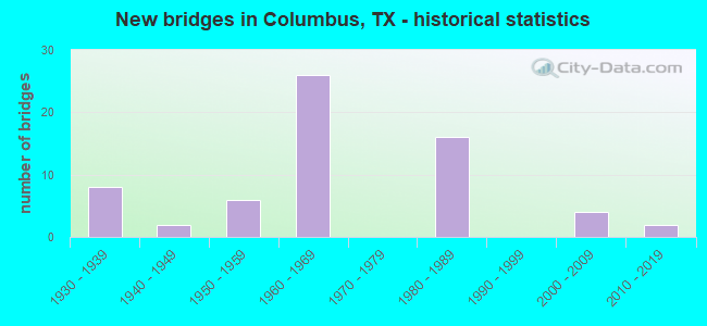
- New bridges - historical statistics
- 81930-1939
- 21940-1949
- 61950-1959
- 261960-1969
- 161980-1989
- 42000-2009
- 22010-2019

- Reconstructed bridges - Historical Statistics
- 11960-1969
- 31970-1979
- 61980-1989
- 01990-1999
- 72000-2009
- 12010-2019


- Bridge Condition - Deck
- 6.5%Very good
- 63.0%Good
- 30.4%Satisfactory

- Bridge Condition - Superstructure
- 4.3%Very good
- 63.0%Good
- 23.9%Satisfactory
- 2.2%Fair
- 6.5%Poor

- Bridge Condition - Substructure
- 2.2%Very good
- 60.9%Good
- 37.0%Satisfactory

- Bridge Condition - Channel
- 10.3%Very good
- 61.5%Good
- 20.5%Satisfactory
- 7.7%Fair

- Bridge Condition - Culverts
- 28.6%Good
- 71.4%Satisfactory
Find on map >> Show street view
Structure Number: 130450002604032, Location: 0.6 Mi E of FM 155 (Lat: 29.701222, Lng: -96.766264), Route carried "on" structure: US 90, Year Built: 1938, Status: Open, Structure Length: 0.73m (2.40ft), Average Daily Traffic: 1,930 (year 2013), Truck Traffic: 11%, Average Future Daily Traffic: 2,700 (year 2033), Features Intersected: Harveys Creek Tributary
Minimum Vertical Clearance: 30+ m (98+ ft), Kilometerpoint: 4.081, Lanes on structure: 2, Owner: State Highway Agency, Approaching Roadway Width: 12.2m (40.0ft), Material/Design: Concrete, Design/Construction: Culvert, Number Of Spans In Main Unit: 3, Length of Maximum Span: 2.1m (6.9ft), Curb-To-Curb Width: 10.3m (33.8ft), Out-to-Out Width: 11.4m (37.4ft)
Condition: Channel: Satisfactory, Culverts: Satisfactory, Operating Rating: 39.9 metric tons, Method Used To Determine Operating Rating: Load Factor (LF), Inventory Rating: 23.6 metric tons, Method Used To Determine Inventory Rating: Load Factor (LF), Structural Evaluation: Equal to present minimum criteria, Deck Geometry: Somewhat better than minimum adequacy, Waterway Adequacy: Equal to present minimum criteria, Approach Roadway Alignment: Equal to present desirable criteria, Designated Inspection Frequency: Every 24 months, Inspection Date: Febuary 2021, Deck Structure Type: Concrete Cast-file-Place, Wearing Surface/Protective System: Wearing Surface: Bituminous
Find on map >> Show street view
Structure Number: 130450002606039, Location: 0.4 Mi E of FM 806 (Lat: 29.705917, Lng: -96.557647), Route carried "on" structure: US 90, Year Built: 1940, Status: Open, Structure Length: 16.00m (52.49ft), Average Daily Traffic: 6,103 (year 2020), Truck Traffic: 11%, Average Future Daily Traffic: 7,160 (year 2033), Design Load: H 15, Features Intersected: Colorado River Relief
Minimum Vertical Clearance: 30+ m (98+ ft), Kilometerpoint: 24.612, Lanes on structure: 2, Owner: State Highway Agency, Approaching Roadway Width: 12.8m (42.0ft), Material/Design: Steel, Design/Construction: Stringer/Multi-beam, Number Of Spans In Main Unit: 15, Length of Maximum Span: 10.7m (35.1ft), Curb or Sidewalk Widths: Left: 0.8m (2.6ft), Right: 0.8m (2.6ft), Curb-To-Curb Width: 7.9m (25.9ft), Out-to-Out Width: 10.0m (32.8ft)
Condition: Deck: Good, Superstructure: Good, Substructure: Good, Channel: Good, Operating Rating: 44.4 metric tons, Method Used To Determine Operating Rating: Load Factor (LF), Inventory Rating: 26.3 metric tons, Method Used To Determine Inventory Rating: Load Factor (LF), Structural Evaluation: Equal to present minimum criteria, Deck Geometry: High priority of corrective action, Waterway Adequacy: Equal to present minimum criteria, Approach Roadway Alignment: Equal to present desirable criteria, Length Of Structure Improvement: 16.00m (52.49ft), Designated Inspection Frequency: Every 24 months, Inspection Date: March 2021, Bridge Improvement Cost: $27,000, Roadway Improvement Cost: $7,000, Total Project Cost: $34,000, Deck Structure Type: Concrete Cast-file-Place, Wearing Surface/Protective System: Wearing Surface: Bituminous
Find on map >> Show street view
Structure Number: 130450002606062, Location: 0.8 Mi W of FM 806 (Lat: 29.703597, Lng: -96.576289), Route carried "on" structure: State highway 71, Year Built: 1982, Status: Open, Structure Length: 18.47m (60.60ft), Average Daily Traffic: 6,070 (year 2015), Truck Traffic: 10%, Average Future Daily Traffic: 7,000 (year 2035), Design Load: HS 20, Features Intersected: US 90 UP RR County Rd
Minimum Vertical Clearance: 30+ m (98+ ft), Kilometerpoint: 6.576, Lanes on structure: 2, Lanes under structure: 4, Owner: State Highway Agency, Approaching Roadway Width: 11.6m (38.1ft), Material/Design: Prestressed concrete continuous, Design/Construction: Stringer/Multi-beam, Number Of Spans In Main Unit: 6, Number Of Approach Spans: 1, Length of Maximum Span: 30.5m (100.1ft), Curb-To-Curb Width: 11.3m (37.1ft), Out-to-Out Width: 12.2m (40.0ft)
Condition: Deck: Satisfactory, Superstructure: Satisfactory, Substructure: Good, Operating Rating: 54.4 metric tons, Method Used To Determine Operating Rating: Assigned rating based on Load Factor Design (LFD) reported in metric tons, Inventory Rating: 32.7 metric tons, Method Used To Determine Inventory Rating: Assigned rating based on Load Factor Design (LFD) reported in metric tons, Structural Evaluation: Equal to present minimum criteria, Deck Geometry: Equal to present minimum criteria, Underclear: Equal to present minimum criteria, Approach Roadway Alignment: Equal to present desirable criteria, Designated Inspection Frequency: Every 24 months, Inspection Date: March 2021, Deck Structure Type: Concrete Cast-file-Place, Wearing Surface/Protective System: Wearing Surface: Bituminous
Find on map >> Show street view
Structure Number: 130450002606063, Location: 0.8 Mi W of FM 806 (Lat: 29.703558, Lng: -96.576500), Route carried "on" structure: State highway 71, Year Built: 1982, Status: Open, Structure Length: 18.47m (60.60ft), Average Daily Traffic: 6,070 (year 2015), Truck Traffic: 10%, Average Future Daily Traffic: 7,000 (year 2035), Design Load: HS 20, Features Intersected: US 90 UP RR County Rd
Minimum Vertical Clearance: 30+ m (98+ ft), Kilometerpoint: 6.576, Lanes on structure: 2, Lanes under structure: 4, Owner: State Highway Agency, Approaching Roadway Width: 11.6m (38.1ft), Material/Design: Prestressed concrete continuous, Design/Construction: Stringer/Multi-beam, Number Of Spans In Main Unit: 5, Number Of Approach Spans: 2, Length of Maximum Span: 30.5m (100.1ft), Curb-To-Curb Width: 11.3m (37.1ft), Out-to-Out Width: 12.2m (40.0ft)
Condition: Deck: Satisfactory, Superstructure: Satisfactory, Substructure: Satisfactory, Operating Rating: 54.4 metric tons, Method Used To Determine Operating Rating: Assigned rating based on Load Factor Design (LFD) reported in metric tons, Inventory Rating: 32.7 metric tons, Method Used To Determine Inventory Rating: Assigned rating based on Load Factor Design (LFD) reported in metric tons, Structural Evaluation: Equal to present minimum criteria, Deck Geometry: Equal to present minimum criteria, Underclear: Equal to present minimum criteria, Approach Roadway Alignment: Equal to present desirable criteria, Designated Inspection Frequency: Every 24 months, Inspection Date: March 2021, Deck Structure Type: Concrete Cast-file-Place
Find on map >> Show street view
Structure Number: 130450002701001, Location: 0.60 Mi E of SH 71 BUS (Lat: 29.706186, Lng: -96.536019), Route carried "on" structure: US 90, Year Built: 1932, Status: Posted for load, Structure Length: 23.35m (76.61ft), Average Daily Traffic: 4,523 (year 2020), Truck Traffic: 11%, Average Future Daily Traffic: 6,720 (year 2033), Design Load: H 15, Features Intersected: Colorado River
Minimum Vertical Clearance: 4.85m (15.91ft), Kilometerpoint: 26.649, Lanes on structure: 2, Owner: State Highway Agency, Approaching Roadway Width: 7.9m (25.9ft), Material/Design: Steel, Design/Construction: Truss - Thru, Number Of Spans In Main Unit: 1, Number Of Approach Spans: 7, Length of Maximum Span: 61.0m (200.1ft), Curb-To-Curb Width: 6.7m (22.0ft), Out-to-Out Width: 7.1m (23.3ft)
Condition: Deck: Satisfactory, Superstructure: Poor, Substructure: Satisfactory, Channel: Fair, Operating Rating: 35.4 metric tons, Method Used To Determine Operating Rating: Load Factor (LF), Inventory Rating: 20.9 metric tons, Method Used To Determine Inventory Rating: Load Factor (LF), Structural Evaluation: Meets minimum limits, Deck Geometry: High priority of replacement, Waterway Adequacy: Equal to present minimum criteria, Approach Roadway Alignment: Equal to present desirable criteria, Bridge Posting: Required (Relationship of Operating Rating to Maximum Legal Load: 10.0 - 19.9% below), Length Of Structure Improvement: 23.35m (76.61ft), Designated Inspection Frequency: Every 24 months, Critical Feature Inspection Frequency: Every 12 months, Underwater Inspection Frequency: Every 60 months, Inspection Date: March 2021, Critical Feature Inspection Date: November 2021, Underwater Inspection Date: January 2018, Bridge Improvement Cost: $34,000, Roadway Improvement Cost: $9,000, Total Project Cost: $43,000, Deck Structure Type: Concrete Cast-file-Place, Wearing Surface/Protective System: Wearing Surface: Bituminous
Find on map >> Show street view
Structure Number: 130450002701044, Location: 0.7 Mi E of SP 52 (Lat: 29.704742, Lng: -96.528678), Route carried "on" structure: US 90, Year Built: 1939, Status: Open, Structure Length: 11.73m (38.48ft), Average Daily Traffic: 4,523 (year 2020), Truck Traffic: 15%, Average Future Daily Traffic: 5,210 (year 2033), Design Load: H 15, Features Intersected: Colorado River Relief
Minimum Vertical Clearance: 30+ m (98+ ft), Kilometerpoint: 27.460, Lanes on structure: 2, Owner: State Highway Agency, Approaching Roadway Width: 8.5m (27.9ft), Material/Design: Steel, Design/Construction: Stringer/Multi-beam, Number Of Spans In Main Unit: 11, Length of Maximum Span: 10.7m (35.1ft), Curb-To-Curb Width: 8.1m (26.6ft), Out-to-Out Width: 9.8m (32.2ft)
Condition: Deck: Good, Superstructure: Good, Substructure: Good, Channel: Good, Operating Rating: 50.8 metric tons, Method Used To Determine Operating Rating: Load Factor (LF), Inventory Rating: 29.9 metric tons, Method Used To Determine Inventory Rating: Load Factor (LF), Structural Evaluation: Better than present minimum criteria, Deck Geometry: High priority of corrective action, Waterway Adequacy: Equal to present minimum criteria, Approach Roadway Alignment: Equal to present desirable criteria, Length Of Structure Improvement: 11.73m (38.48ft), Designated Inspection Frequency: Every 24 months, Inspection Date: March 2021, Bridge Improvement Cost: $21,000, Roadway Improvement Cost: $5,000, Total Project Cost: $26,000, Deck Structure Type: Concrete Cast-file-Place, Wearing Surface/Protective System: Wearing Surface: Bituminous
Find on map >> Show street view
Structure Number: 130450002701045, Location: 0.9 Mi E of SP 52 (Lat: 29.704183, Lng: -96.525928), Route carried "on" structure: US 90, Year Built: 1939, Status: Open, Structure Length: 12.80m (41.99ft), Average Daily Traffic: 4,523 (year 2020), Truck Traffic: 15%, Average Future Daily Traffic: 5,210 (year 2033), Design Load: H 15, Features Intersected: Colorado River Relief
Minimum Vertical Clearance: 30+ m (98+ ft), Kilometerpoint: 27.715, Lanes on structure: 2, Owner: State Highway Agency, Approaching Roadway Width: 10.4m (34.1ft), Material/Design: Steel, Design/Construction: Stringer/Multi-beam, Number Of Spans In Main Unit: 12, Length of Maximum Span: 10.7m (35.1ft), Curb-To-Curb Width: 8.1m (26.6ft), Out-to-Out Width: 9.8m (32.2ft)
Condition: Deck: Good, Superstructure: Good, Substructure: Good, Channel: Good, Operating Rating: 50.8 metric tons, Method Used To Determine Operating Rating: Load Factor (LF), Inventory Rating: 29.9 metric tons, Method Used To Determine Inventory Rating: Load Factor (LF), Structural Evaluation: Better than present minimum criteria, Deck Geometry: High priority of corrective action, Waterway Adequacy: Equal to present minimum criteria, Approach Roadway Alignment: Equal to present desirable criteria, Length Of Structure Improvement: 12.80m (41.99ft), Designated Inspection Frequency: Every 24 months, Inspection Date: March 2021, Bridge Improvement Cost: $23,000, Roadway Improvement Cost: $6,000, Total Project Cost: $29,000, Deck Structure Type: Concrete Cast-file-Place, Wearing Surface/Protective System: Wearing Surface: Bituminous
Find on map >> Show street view
Structure Number: 130450002701046, Location: 1.2 Mi E of SP 52 (Lat: 29.703342, Lng: -96.521653), Route carried "on" structure: US 90, Year Built: 1939, Status: Open, Structure Length: 4.27m (14.01ft), Average Daily Traffic: 4,523 (year 2020), Truck Traffic: 15%, Average Future Daily Traffic: 5,210 (year 2033), Design Load: H 15, Features Intersected: Colorado River Relief
Minimum Vertical Clearance: 30+ m (98+ ft), Kilometerpoint: 28.173, Lanes on structure: 2, Owner: State Highway Agency, Approaching Roadway Width: 10.4m (34.1ft), Material/Design: Steel, Design/Construction: Stringer/Multi-beam, Number Of Spans In Main Unit: 4, Length of Maximum Span: 10.7m (35.1ft), Curb-To-Curb Width: 8.0m (26.2ft), Out-to-Out Width: 9.8m (32.2ft)
Condition: Deck: Good, Superstructure: Good, Substructure: Good, Channel: Good, Operating Rating: 50.8 metric tons, Method Used To Determine Operating Rating: Load Factor (LF), Inventory Rating: 29.9 metric tons, Method Used To Determine Inventory Rating: Load Factor (LF), Structural Evaluation: Better than present minimum criteria, Deck Geometry: High priority of corrective action, Waterway Adequacy: Equal to present minimum criteria, Approach Roadway Alignment: Equal to present desirable criteria, Length Of Structure Improvement: 4.27m (14.01ft), Designated Inspection Frequency: Every 24 months, Inspection Date: March 2021, Bridge Improvement Cost: $7,000, Roadway Improvement Cost: $2,000, Total Project Cost: $9,000, Deck Structure Type: Concrete Cast-file-Place, Wearing Surface/Protective System: Wearing Surface: Bituminous
Find on map >> Show street view
Structure Number: 130450026602056, Location: 1.25 Mi SE of FM 1890 (Lat: 29.732833, Lng: -96.583069), Route carried "on" structure: State highway 71, Year Built: 1982, Status: Open, Structure Length: 4.88m (16.01ft), Average Daily Traffic: 5,899 (year 2020), Truck Traffic: 12%, Average Future Daily Traffic: 7,450 (year 2033), Design Load: HS 20, Features Intersected: BU 71 F
Minimum Vertical Clearance: 30+ m (98+ ft), Kilometerpoint: 16.066, Lanes on structure: 2, Lanes under structure: 2, Owner: State Highway Agency, Approaching Roadway Width: 11.6m (38.1ft), Material/Design: Prestressed concrete continuous, Design/Construction: Stringer/Multi-beam, Number Of Spans In Main Unit: 3, Length of Maximum Span: 18.3m (60.0ft), Curb-To-Curb Width: 11.3m (37.1ft), Out-to-Out Width: 12.2m (40.0ft)
Condition: Deck: Satisfactory, Superstructure: Good, Substructure: Good, Operating Rating: 54.4 metric tons, Method Used To Determine Operating Rating: Assigned rating based on Load Factor Design (LFD) reported in metric tons, Inventory Rating: 32.7 metric tons, Method Used To Determine Inventory Rating: Assigned rating based on Load Factor Design (LFD) reported in metric tons, Structural Evaluation: Better than present minimum criteria, Deck Geometry: Equal to present minimum criteria, Underclear: Superior to present desirable criteria, Approach Roadway Alignment: Equal to present desirable criteria, Designated Inspection Frequency: Every 24 months, Inspection Date: March 2021, Deck Structure Type: Concrete Cast-file-Place
Find on map >> Show street view
Structure Number: 130450026602057, Location: 1.25 MI SE OF FM 1890 (Lat: 29.733003, Lng: -96.582742), Route carried "on" structure: State highway 71, Year Built: 1982, Status: Open, Structure Length: 4.88m (16.01ft), Average Daily Traffic: 6,161 (year 2019), Truck Traffic: 12%, Average Future Daily Traffic: 7,450 (year 2033), Design Load: HS 20, Features Intersected: BU 71 F
Minimum Vertical Clearance: 30+ m (98+ ft), Kilometerpoint: 16.066, Lanes on structure: 2, Lanes under structure: 2, Owner: State Highway Agency, Approaching Roadway Width: 11.6m (38.1ft), Material/Design: Prestressed concrete continuous, Design/Construction: Stringer/Multi-beam, Number Of Spans In Main Unit: 3, Length of Maximum Span: 18.3m (60.0ft), Curb-To-Curb Width: 11.3m (37.1ft), Out-to-Out Width: 12.2m (40.0ft)
Condition: Deck: Satisfactory, Superstructure: Good, Substructure: Good, Operating Rating: 54.4 metric tons, Method Used To Determine Operating Rating: Assigned rating based on Load Factor Design (LFD) reported in metric tons, Inventory Rating: 32.7 metric tons, Method Used To Determine Inventory Rating: Assigned rating based on Load Factor Design (LFD) reported in metric tons, Structural Evaluation: Better than present minimum criteria, Deck Geometry: Equal to present minimum criteria, Underclear: Superior to present desirable criteria, Approach Roadway Alignment: Equal to present desirable criteria, Designated Inspection Frequency: Every 24 months, Inspection Date: March 2021, Deck Structure Type: Concrete Cast-file-Place, Wearing Surface/Protective System: Wearing Surface: Bituminous
Find on map >> Show street view
Structure Number: 130450026602058, Location: 1.2 Mi N of US 90 (Lat: 29.718906, Lng: -96.579639), Route carried "on" structure: State highway 71, Year Built: 1982, Status: Open, Structure Length: 26.67m (87.50ft), Average Daily Traffic: 6,161 (year 2019), Truck Traffic: 12%, Average Future Daily Traffic: 7,450 (year 2033), Design Load: HS 20, Features Intersected: Colorado River
Minimum Vertical Clearance: 30+ m (98+ ft), Kilometerpoint: 17.391, Lanes on structure: 2, Owner: State Highway Agency, Approaching Roadway Width: 11.6m (38.1ft), Skew: 1 degrees, Material/Design: Prestressed concrete continuous, Design/Construction: Stringer/Multi-beam, Number Of Spans In Main Unit: 4, Number Of Approach Spans: 5, Length of Maximum Span: 36.6m (120.1ft), Curb-To-Curb Width: 11.3m (37.1ft), Out-to-Out Width: 12.2m (40.0ft)
Condition: Deck: Satisfactory, Superstructure: Satisfactory, Substructure: Good, Channel: Fair, Operating Rating: 54.4 metric tons, Method Used To Determine Operating Rating: Assigned rating based on Load Factor Design (LFD) reported in metric tons, Inventory Rating: 32.7 metric tons, Method Used To Determine Inventory Rating: Assigned rating based on Load Factor Design (LFD) reported in metric tons, Structural Evaluation: Equal to present minimum criteria, Deck Geometry: Equal to present minimum criteria, Waterway Adequacy: Superior to present desirable criteria, Approach Roadway Alignment: Equal to present desirable criteria, Designated Inspection Frequency: Every 24 months, Inspection Date: March 2021, Deck Structure Type: Concrete Cast-file-Place, Wearing Surface/Protective System: Wearing Surface: Bituminous
Find on map >> Show street view
Structure Number: 130450026602059, Location: 1.2 Mi N of US 90 (Lat: 29.721281, Lng: -96.580250), Route carried "on" structure: State highway 71, Year Built: 1982, Status: Open, Structure Length: 26.67m (87.50ft), Average Daily Traffic: 5,899 (year 2020), Truck Traffic: 12%, Average Future Daily Traffic: 7,450 (year 2033), Design Load: HS 20, Features Intersected: Colorado River
Minimum Vertical Clearance: 30+ m (98+ ft), Kilometerpoint: 17.391, Lanes on structure: 2, Owner: State Highway Agency, Approaching Roadway Width: 11.6m (38.1ft), Skew: 1 degrees, Material/Design: Prestressed concrete continuous, Design/Construction: Stringer/Multi-beam, Number Of Spans In Main Unit: 4, Number Of Approach Spans: 5, Length of Maximum Span: 36.6m (120.1ft), Curb-To-Curb Width: 11.3m (37.1ft), Out-to-Out Width: 12.2m (40.0ft)
Condition: Deck: Good, Superstructure: Satisfactory, Substructure: Good, Channel: Satisfactory, Operating Rating: 54.4 metric tons, Method Used To Determine Operating Rating: Assigned rating based on Load Factor Design (LFD) reported in metric tons, Inventory Rating: 32.7 metric tons, Method Used To Determine Inventory Rating: Assigned rating based on Load Factor Design (LFD) reported in metric tons, Structural Evaluation: Equal to present minimum criteria, Deck Geometry: Equal to present minimum criteria, Waterway Adequacy: Superior to present desirable criteria, Approach Roadway Alignment: Equal to present desirable criteria, Designated Inspection Frequency: Every 24 months, Inspection Date: March 2021, Deck Structure Type: Concrete Cast-file-Place, Wearing Surface/Protective System: Wearing Surface: Bituminous
Find on map >> Show street view
Structure Number: 13045002660206, Location: 0.9 Mi N of US 90 (Lat: 29.716894, Lng: -96.579489), Route carried "on" structure: State highway 71, Year Built: 1982, Status: Open, Structure Length: 4.57m (14.99ft), Average Daily Traffic: 6,161 (year 2019), Truck Traffic: 12%, Average Future Daily Traffic: 7,450 (year 2033), Design Load: HS 20, Features Intersected: Colorado River Relief
Minimum Vertical Clearance: 30+ m (98+ ft), Kilometerpoint: 17.828, Lanes on structure: 2, Owner: State Highway Agency, Approaching Roadway Width: 11.6m (38.1ft), Material/Design: Prestressed concrete continuous, Design/Construction: Stringer/Multi-beam, Number Of Spans In Main Unit: 3, Length of Maximum Span: 18.3m (60.0ft), Curb-To-Curb Width: 11.3m (37.1ft), Out-to-Out Width: 12.2m (40.0ft)
Condition: Deck: Good, Superstructure: Good, Substructure: Good, Channel: Good, Operating Rating: 54.4 metric tons, Method Used To Determine Operating Rating: Assigned rating based on Load Factor Design (LFD) reported in metric tons, Inventory Rating: 32.7 metric tons, Method Used To Determine Inventory Rating: Assigned rating based on Load Factor Design (LFD) reported in metric tons, Structural Evaluation: Better than present minimum criteria, Deck Geometry: Equal to present minimum criteria, Waterway Adequacy: Superior to present desirable criteria, Approach Roadway Alignment: Equal to present desirable criteria, Designated Inspection Frequency: Every 24 months, Inspection Date: March 2021, Deck Structure Type: Concrete Cast-file-Place, Wearing Surface/Protective System: Wearing Surface: Bituminous
Find on map >> Show street view
Structure Number: 130450026602061, Location: 0.9 Mi N of US 90 (Lat: 29.716844, Lng: -96.579817), Route carried "on" structure: State highway 71, Year Built: 1982, Status: Open, Structure Length: 4.57m (14.99ft), Average Daily Traffic: 5,899 (year 2020), Truck Traffic: 12%, Average Future Daily Traffic: 7,450 (year 2033), Design Load: HS 20, Features Intersected: Colorado River Relief
Minimum Vertical Clearance: 30+ m (98+ ft), Kilometerpoint: 17.828, Lanes on structure: 2, Owner: State Highway Agency, Approaching Roadway Width: 11.6m (38.1ft), Material/Design: Prestressed concrete continuous, Design/Construction: Stringer/Multi-beam, Number Of Spans In Main Unit: 3, Length of Maximum Span: 18.3m (60.0ft), Curb-To-Curb Width: 11.3m (37.1ft), Out-to-Out Width: 12.2m (40.0ft)
Condition: Deck: Satisfactory, Superstructure: Good, Substructure: Good, Channel: Good, Operating Rating: 54.4 metric tons, Method Used To Determine Operating Rating: Assigned rating based on Load Factor Design (LFD) reported in metric tons, Inventory Rating: 32.7 metric tons, Method Used To Determine Inventory Rating: Assigned rating based on Load Factor Design (LFD) reported in metric tons, Structural Evaluation: Better than present minimum criteria, Deck Geometry: Equal to present minimum criteria, Waterway Adequacy: Superior to present desirable criteria, Approach Roadway Alignment: Equal to present desirable criteria, Designated Inspection Frequency: Every 24 months, Inspection Date: March 2021, Deck Structure Type: Concrete Cast-file-Place
Find on map >> Show street view
Structure Number: 130450026602069, Location: 0.55 MI NW OF FM 1890 (Lat: 29.750294, Lng: -96.603589), Route carried "on" structure: State highway 71, Year Built: 1988, Status: Open, Structure Length: 2.26m (7.41ft), Average Daily Traffic: 12,093 (year 2020), Truck Traffic: 17%, Average Future Daily Traffic: 15,500 (year 2033), Features Intersected: YUPON CREEK
Minimum Vertical Clearance: 30+ m (98+ ft), Kilometerpoint: 13.238, Lanes on structure: 4, Owner: State Highway Agency, Approaching Roadway Width: 23.2m (76.1ft), Skew: 29 degrees, Material/Design: Concrete, Design/Construction: Culvert, Number Of Spans In Main Unit: 5, Length of Maximum Span: 3.0m (9.8ft)
Condition: Channel: Satisfactory, Culverts: Satisfactory, Operating Rating: 39.9 metric tons, Method Used To Determine Operating Rating: Load Factor (LF), Inventory Rating: 23.6 metric tons, Method Used To Determine Inventory Rating: Load Factor (LF), Structural Evaluation: Somewhat better than minimum adequacy, Waterway Adequacy: Superior to present desirable criteria, Approach Roadway Alignment: Equal to present desirable criteria, Designated Inspection Frequency: Every 48 months, Inspection Date: March 2021
Find on map >> Show street view
Structure Number: 130450026603024, Location: 0.40 Mi S of IH 10 (Lat: 29.686964, Lng: -96.537264), Route carried "on" structure: State highway 71, Year Built: 1933, Year Reconstructed: 1969, Status: Open, Structure Length: 6.95m (22.80ft), Average Daily Traffic: 7,649 (year 2020), Truck Traffic: 22%, Average Future Daily Traffic: 15,670 (year 2033), Features Intersected: Ratliff Creek
Minimum Vertical Clearance: 30+ m (98+ ft), Kilometerpoint: 3.975, Lanes on structure: 2, Owner: State Highway Agency, Approaching Roadway Width: 12.8m (42.0ft), Material/Design: Concrete, Design/Construction: Tee Beam, Number Of Spans In Main Unit: 8, Length of Maximum Span: 8.8m (28.9ft), Curb-To-Curb Width: 14.6m (47.9ft), Out-to-Out Width: 15.3m (50.2ft)
Condition: Deck: Good, Superstructure: Good, Substructure: Good, Channel: Good, Operating Rating: 50.8 metric tons, Method Used To Determine Operating Rating: Load Factor (LF), Inventory Rating: 29.9 metric tons, Method Used To Determine Inventory Rating: Load Factor (LF), Structural Evaluation: Better than present minimum criteria, Deck Geometry: Superior to present desirable criteria, Waterway Adequacy: Equal to present minimum criteria, Approach Roadway Alignment: Equal to present desirable criteria, Designated Inspection Frequency: Every 24 months, Inspection Date: March 2021, Deck Structure Type: Concrete Cast-file-Place, Wearing Surface/Protective System: Wearing Surface: Bituminous
Find on map >> Show street view
Structure Number: 130450026603025, Location: 2.00 Mi S of IH 10 (Lat: 29.664711, Lng: -96.531869), Route carried "on" structure: State highway 71, Year Built: 1933, Year Reconstructed: 2018, Status: Open, Structure Length: 1.07m (3.51ft), Average Daily Traffic: 7,649 (year 2020), Truck Traffic: 22%, Average Future Daily Traffic: 15,670 (year 2033), Features Intersected: Wolfpen Creek
Minimum Vertical Clearance: 30+ m (98+ ft), Kilometerpoint: 6.558, Lanes on structure: 2, Owner: State Highway Agency, Approaching Roadway Width: 16.5m (54.1ft), Material/Design: Concrete, Design/Construction: Culvert, Number Of Spans In Main Unit: 4, Length of Maximum Span: 2.4m (7.9ft), Curb-To-Curb Width: 16.5m (54.1ft), Out-to-Out Width: 17.2m (56.4ft)
Condition: Channel: Good, Culverts: Good, Operating Rating: 39.9 metric tons, Method Used To Determine Operating Rating: Load Factor (LF), Inventory Rating: 23.6 metric tons, Method Used To Determine Inventory Rating: Load Factor (LF), Structural Evaluation: Somewhat better than minimum adequacy, Deck Geometry: Superior to present desirable criteria, Waterway Adequacy: Equal to present minimum criteria, Approach Roadway Alignment: Equal to present desirable criteria, Designated Inspection Frequency: Every 24 months, Inspection Date: March 2021, Deck Structure Type: Concrete Cast-file-Place, Wearing Surface/Protective System: Wearing Surface: Bituminous
Find on map >> Show street view
Structure Number: 130450026608019, Location: 1.40 Mi NW of FM 109 (Lat: 29.728458, Lng: -96.573256), Route carried "on" structure: Business State highway 71, Year Built: 1958, Year Reconstructed: 1982, Status: Open, Structure Length: 1.13m (3.71ft), Average Daily Traffic: 2,180 (year 2013), Truck Traffic: 16%, Average Future Daily Traffic: 3,050 (year 2033), Features Intersected: Draw
Minimum Vertical Clearance: 30+ m (98+ ft), Kilometerpoint: 2.754, Lanes on structure: 2, Owner: State Highway Agency, Approaching Roadway Width: 12.8m (42.0ft), Skew: 4 degrees, Material/Design: Concrete, Design/Construction: Culvert, Number Of Spans In Main Unit: 4, Length of Maximum Span: 1.8m (5.9ft), Curb-To-Curb Width: 13.4m (44.0ft), Out-to-Out Width: 13.9m (45.6ft)
Condition: Channel: Good, Culverts: Satisfactory, Operating Rating: 39.9 metric tons, Method Used To Determine Operating Rating: Load Factor (LF), Inventory Rating: 23.6 metric tons, Method Used To Determine Inventory Rating: Load Factor (LF), Structural Evaluation: Equal to present minimum criteria, Deck Geometry: Better than present minimum criteria, Waterway Adequacy: Equal to present minimum criteria, Approach Roadway Alignment: Equal to present desirable criteria, Designated Inspection Frequency: Every 24 months, Inspection Date: March 2021, Wearing Surface/Protective System: Wearing Surface: Bituminous
Find on map >> Show street view
Structure Number: 13045002660802, Location: 1.10 Mi NW of FM 109 (Lat: 29.726458, Lng: -96.569231), Route carried "on" structure: Business State highway 71, Year Built: 1958, Year Reconstructed: 1982, Status: Open, Structure Length: 0.82m (2.69ft), Average Daily Traffic: 2,180 (year 2013), Truck Traffic: 16%, Average Future Daily Traffic: 3,050 (year 2033), Features Intersected: Draw
Minimum Vertical Clearance: 30+ m (98+ ft), Kilometerpoint: 3.228, Lanes on structure: 2, Owner: State Highway Agency, Approaching Roadway Width: 12.8m (42.0ft), Material/Design: Concrete, Design/Construction: Culvert, Number Of Spans In Main Unit: 4, Length of Maximum Span: 1.8m (5.9ft), Curb-To-Curb Width: 13.4m (44.0ft), Out-to-Out Width: 13.8m (45.3ft)
Condition: Channel: Good, Culverts: Satisfactory, Operating Rating: 39.9 metric tons, Method Used To Determine Operating Rating: Load Factor (LF), Inventory Rating: 23.6 metric tons, Method Used To Determine Inventory Rating: Load Factor (LF), Structural Evaluation: Equal to present minimum criteria, Deck Geometry: Better than present minimum criteria, Waterway Adequacy: Equal to present minimum criteria, Approach Roadway Alignment: Equal to present desirable criteria, Designated Inspection Frequency: Every 24 months, Inspection Date: March 2021, Wearing Surface/Protective System: Wearing Surface: Bituminous
Find on map >> Show street view
Structure Number: 130450026608021, Location: 0.05 Mi NW of FM 109 (Lat: 29.719889, Lng: -96.552678), Route carried "on" structure: Business State highway 71, Year Built: 1958, Year Reconstructed: 1982, Status: Open, Structure Length: 0.82m (2.69ft), Average Daily Traffic: 2,978 (year 2020), Truck Traffic: 16%, Average Future Daily Traffic: 3,050 (year 2033), Features Intersected: Draw
Minimum Vertical Clearance: 30+ m (98+ ft), Kilometerpoint: 4.955, Lanes on structure: 2, Owner: State Highway Agency, Approaching Roadway Width: 12.8m (42.0ft), Material/Design: Concrete, Design/Construction: Culvert, Number Of Spans In Main Unit: 4, Length of Maximum Span: 1.8m (5.9ft), Curb-To-Curb Width: 13.4m (44.0ft), Out-to-Out Width: 13.8m (45.3ft)
Condition: Channel: Good, Culverts: Satisfactory, Operating Rating: 39.9 metric tons, Method Used To Determine Operating Rating: Load Factor (LF), Inventory Rating: 23.6 metric tons, Method Used To Determine Inventory Rating: Load Factor (LF), Structural Evaluation: Equal to present minimum criteria, Deck Geometry: Better than present minimum criteria, Waterway Adequacy: Equal to present minimum criteria, Approach Roadway Alignment: Equal to present desirable criteria, Designated Inspection Frequency: Every 24 months, Inspection Date: March 2021, Wearing Surface/Protective System: Wearing Surface: Bituminous
Find on map >> Show street view
Structure Number: 130450026608043, Location: 0.50 Mi N of US 90 (Lat: 29.713292, Lng: -96.547511), Route carried "on" structure: Business State highway 71, Year Built: 1949, Status: Not yet open, Structure Length: 31.76m (104.20ft), Average Daily Traffic: 4,820 (year 2013), Truck Traffic: 16%, Average Future Daily Traffic: 6,750 (year 2033), Design Load: H 20, Features Intersected: Colorado River
Minimum Vertical Clearance: 4.85m (15.91ft), Kilometerpoint: 5.741, Lanes on structure: 2, Owner: State Highway Agency, Approaching Roadway Width: 7.9m (25.9ft), Material/Design: Steel, Design/Construction: Truss - Thru, Number Of Spans In Main Unit: 3, Number Of Approach Spans: 7, Length of Maximum Span: 68.6m (225.1ft), Curb or Sidewalk Widths: Left: 0.6m (2.0ft), Right: 0.6m (2.0ft), Curb-To-Curb Width: 7.9m (25.9ft), Out-to-Out Width: 9.5m (31.2ft)
Condition: Deck: Satisfactory, Superstructure: Satisfactory, Substructure: Good, Channel: Satisfactory, Operating Rating: 42.6 metric tons, Method Used To Determine Operating Rating: Load Factor (LF), Inventory Rating: 25.4 metric tons, Method Used To Determine Inventory Rating: Load Factor (LF), Structural Evaluation: Equal to present minimum criteria, Deck Geometry: High priority of corrective action, Waterway Adequacy: Superior to present desirable criteria, Approach Roadway Alignment: Equal to present desirable criteria, Length Of Structure Improvement: 31.76m (104.20ft), Designated Inspection Frequency: Every 24 months, Critical Feature Inspection Frequency: Every 24 months, Underwater Inspection Frequency: Every 60 months, Inspection Date: March 2021, Critical Feature Inspection Date: August 2021, Underwater Inspection Date: January 2018, Bridge Improvement Cost: $54,000, Roadway Improvement Cost: $14,000, Total Project Cost: $68,000, Deck Structure Type: Concrete Cast-file-Place, Wearing Surface/Protective System: Wearing Surface: Bituminous
Find on map >> Show street view
Structure Number: 130450026608194, Location: 0.50 MI N OF US 90 (Lat: 29.713292, Lng: -96.547511), Route carried "on" structure: State highway 71, Year Built: 2019, Status: Open, Structure Length: 31.73m (104.10ft), Average Daily Traffic: 5,408 (year 2018), Truck Traffic: 5%, Average Future Daily Traffic: 6,930 (year 2038), Design Load: HL 93, Features Intersected: COLORADO RIVER
Minimum Vertical Clearance: 30+ m (98+ ft), Kilometerpoint: 0.805, Lanes on structure: 2, Owner: State Highway Agency, Approaching Roadway Width: 13.4m (44.0ft), Material/Design: Steel continuous, Design/Construction: Stringer/Multi-beam, Number Of Spans In Main Unit: 3, Number Of Approach Spans: 4, Length of Maximum Span: 69.2m (227.0ft), Curb or Sidewalk Widths: Left: 0.0m, Right: 1.8m (5.9ft), Curb-To-Curb Width: 13.4m (44.0ft), Out-to-Out Width: 16.2m (53.1ft)
Condition: Deck: Good, Superstructure: Good, Substructure: Good, Channel: Good, Operating Rating: 54.4 metric tons, Method Used To Determine Operating Rating: Assigned ratings based on Load and Resistance Factor Design (LRFD) reported in metric tons, Inventory Rating: 32.7 metric tons, Method Used To Determine Inventory Rating: Assigned ratings based on Load and Resistance Factor Design (LRFD) reported in metric tons, Structural Evaluation: Better than present minimum criteria, Deck Geometry: Equal to present minimum criteria, Waterway Adequacy: Superior to present desirable criteria, Approach Roadway Alignment: Equal to present desirable criteria, Designated Inspection Frequency: Every 24 months, Inspection Date: March 2021, Deck Structure Type: Concrete Cast-file-Place
Find on map >> Show street view
Structure Number: 130450027101088, Location: 1.0 Mi NE of SH 71 (Lat: 29.700381, Lng: -96.524869), Route carried "on" structure: Interstate 10, Year Built: 1961, Year Reconstructed: 1989, Status: Open, Structure Length: 17.56m (57.61ft), Average Daily Traffic: 23,770 (year 2017), Truck Traffic: 33%, Average Future Daily Traffic: 31,130 (year 2033), Features Intersected: Colorado River E Rel #1
Minimum Vertical Clearance: 30+ m (98+ ft), Kilometerpoint: 31.640, Lanes on structure: 2, Owner: State Highway Agency, Approaching Roadway Width: 11.6m (38.1ft), Material/Design: Concrete, Design/Construction: Stringer/Multi-beam, Number Of Spans In Main Unit: 19, Length of Maximum Span: 9.1m (29.9ft), Curb-To-Curb Width: 10.8m (35.4ft), Out-to-Out Width: 12.0m (39.4ft)
Condition: Deck: Good, Superstructure: Good, Substructure: Satisfactory, Channel: Very good, Operating Rating: 68.0 metric tons, Method Used To Determine Operating Rating: Load Factor (LF), Inventory Rating: 40.8 metric tons, Method Used To Determine Inventory Rating: Load Factor (LF), Structural Evaluation: Equal to present minimum criteria, Deck Geometry: Meets minimum limits, Waterway Adequacy: Superior to present desirable criteria, Approach Roadway Alignment: Equal to present desirable criteria, Designated Inspection Frequency: Every 24 months, Inspection Date: Febuary 2021, Deck Structure Type: Concrete Cast-file-Place, Wearing Surface/Protective System: Wearing Surface: Bituminous
Find on map >> Show street view
Structure Number: 130450027101089, Location: 1.0 Mi NE of SH 71 (Lat: 29.700222, Lng: -96.524767), Route carried "on" structure: Interstate 10, Year Built: 1961, Year Reconstructed: 1989, Status: Open, Structure Length: 17.56m (57.61ft), Average Daily Traffic: 22,625 (year 2017), Truck Traffic: 33%, Average Future Daily Traffic: 31,130 (year 2033), Features Intersected: Colorado River E Rel #1
Minimum Vertical Clearance: 30+ m (98+ ft), Kilometerpoint: 31.640, Lanes on structure: 2, Owner: State Highway Agency, Approaching Roadway Width: 11.6m (38.1ft), Material/Design: Concrete, Design/Construction: Stringer/Multi-beam, Number Of Spans In Main Unit: 19, Length of Maximum Span: 9.1m (29.9ft), Curb-To-Curb Width: 10.8m (35.4ft), Out-to-Out Width: 12.0m (39.4ft)
Condition: Deck: Good, Superstructure: Good, Substructure: Satisfactory, Channel: Good, Operating Rating: 68.0 metric tons, Method Used To Determine Operating Rating: Load Factor (LF), Inventory Rating: 40.8 metric tons, Method Used To Determine Inventory Rating: Load Factor (LF), Structural Evaluation: Equal to present minimum criteria, Deck Geometry: Meets minimum limits, Waterway Adequacy: Superior to present desirable criteria, Approach Roadway Alignment: Equal to present desirable criteria, Designated Inspection Frequency: Every 24 months, Inspection Date: Febuary 2021, Deck Structure Type: Concrete Cast-file-Place, Wearing Surface/Protective System: Wearing Surface: Bituminous
Find on map >> Show street view
Structure Number: 13045002710109, Location: 1.3 Mi NE of SH 71 (Lat: 29.701503, Lng: -96.521867), Route carried "on" structure: Interstate 10, Year Built: 1961, Status: Open, Structure Length: 4.63m (15.19ft), Average Daily Traffic: 23,770 (year 2017), Truck Traffic: 33%, Average Future Daily Traffic: 31,130 (year 2033), Design Load: HS 20, Features Intersected: Colorado River E Rel #2
Minimum Vertical Clearance: 30+ m (98+ ft), Kilometerpoint: 32.048, Lanes on structure: 2, Owner: State Highway Agency, Approaching Roadway Width: 11.6m (38.1ft), Material/Design: Concrete, Design/Construction: Stringer/Multi-beam, Number Of Spans In Main Unit: 5, Length of Maximum Span: 9.1m (29.9ft), Curb-To-Curb Width: 11.2m (36.7ft), Out-to-Out Width: 12.1m (39.7ft)
Condition: Deck: Satisfactory, Superstructure: Satisfactory, Substructure: Good, Channel: Good, Operating Rating: 68.0 metric tons, Method Used To Determine Operating Rating: Load Factor (LF), Inventory Rating: 40.8 metric tons, Method Used To Determine Inventory Rating: Load Factor (LF), Structural Evaluation: Equal to present minimum criteria, Deck Geometry: Somewhat better than minimum adequacy, Waterway Adequacy: Superior to present desirable criteria, Approach Roadway Alignment: Equal to present desirable criteria, Designated Inspection Frequency: Every 24 months, Inspection Date: Febuary 2021, Deck Structure Type: Concrete Cast-file-Place, Wearing Surface/Protective System: Wearing Surface: Bituminous
Find on map >> Show street view
Structure Number: 130450027101091, Location: 1.3 MI NE of SH 71 (Lat: 29.701325, Lng: -96.521775), Route carried "on" structure: Interstate 10, Year Built: 1961, Status: Open, Structure Length: 4.63m (15.19ft), Average Daily Traffic: 22,625 (year 2017), Truck Traffic: 33%, Average Future Daily Traffic: 31,130 (year 2033), Design Load: HS 20, Features Intersected: Colorado River E Rel #2
Minimum Vertical Clearance: 30+ m (98+ ft), Kilometerpoint: 32.048, Lanes on structure: 2, Owner: State Highway Agency, Approaching Roadway Width: 11.6m (38.1ft), Material/Design: Concrete, Design/Construction: Stringer/Multi-beam, Number Of Spans In Main Unit: 5, Length of Maximum Span: 9.1m (29.9ft), Curb-To-Curb Width: 11.2m (36.7ft), Out-to-Out Width: 12.1m (39.7ft)
Condition: Deck: Satisfactory, Superstructure: Good, Substructure: Good, Channel: Good, Operating Rating: 68.0 metric tons, Method Used To Determine Operating Rating: Load Factor (LF), Inventory Rating: 40.8 metric tons, Method Used To Determine Inventory Rating: Load Factor (LF), Structural Evaluation: Better than present minimum criteria, Deck Geometry: Somewhat better than minimum adequacy, Waterway Adequacy: Superior to present desirable criteria, Approach Roadway Alignment: Equal to present desirable criteria, Length Of Structure Improvement: 4.63m (15.19ft), Designated Inspection Frequency: Every 24 months, Inspection Date: Febuary 2021, Deck Structure Type: Concrete Cast-file-Place, Wearing Surface/Protective System: Wearing Surface: Bituminous
Find on map >> Show street view
Structure Number: 130450027101092, Location: 1.65 Mi NE of SH 71 (Lat: 29.703550, Lng: -96.515775), Route carried "on" structure: Interstate 10, Year Built: 1961, Year Reconstructed: 1987, Status: Open, Structure Length: 14.23m (46.69ft), Average Daily Traffic: 23,770 (year 2017), Truck Traffic: 33%, Average Future Daily Traffic: 31,130 (year 2033), Design Load: HS 20, Features Intersected: UPRR
Minimum Vertical Clearance: 30+ m (98+ ft), Kilometerpoint: 32.617, Lanes on structure: 2, Owner: State Highway Agency, Approaching Roadway Width: 11.6m (38.1ft), Skew: 9 degrees, Material/Design: Steel, Design/Construction: Stringer/Multi-beam, Number Of Spans In Main Unit: 3, Number Of Approach Spans: 11, Length of Maximum Span: 13.7m (44.9ft), Curb-To-Curb Width: 11.5m (37.7ft), Out-to-Out Width: 12.5m (41.0ft)
Condition: Deck: Good, Superstructure: Good, Substructure: Satisfactory, Operating Rating: 44.4 metric tons, Method Used To Determine Operating Rating: Load Factor (LF), Inventory Rating: 26.3 metric tons, Method Used To Determine Inventory Rating: Load Factor (LF), Structural Evaluation: Equal to present minimum criteria, Deck Geometry: Somewhat better than minimum adequacy, Underclear: Meets minimum limits, Approach Roadway Alignment: Equal to present desirable criteria, Designated Inspection Frequency: Every 24 months, Critical Feature Inspection Frequency: Every 24 months, Inspection Date: Febuary 2021, Critical Feature Inspection Date: October 2020, Deck Structure Type: Concrete Cast-file-Place, Wearing Surface/Protective System: Wearing Surface: Bituminous
Find on map >> Show street view
Structure Number: 130450027101093, Location: 1.65 Mi NE of SH 71 (Lat: 29.703386, Lng: -96.515686), Route carried "on" structure: Interstate 10, Year Built: 1961, Year Reconstructed: 1987, Status: Open, Structure Length: 14.23m (46.69ft), Average Daily Traffic: 22,625 (year 2017), Truck Traffic: 33%, Average Future Daily Traffic: 31,130 (year 2033), Design Load: HS 20, Features Intersected: UPRR
Minimum Vertical Clearance: 30+ m (98+ ft), Kilometerpoint: 32.652, Lanes on structure: 2, Owner: State Highway Agency, Approaching Roadway Width: 11.6m (38.1ft), Skew: 9 degrees, Material/Design: Steel, Design/Construction: Stringer/Multi-beam, Number Of Spans In Main Unit: 3, Number Of Approach Spans: 11, Length of Maximum Span: 13.7m (44.9ft), Curb-To-Curb Width: 11.5m (37.7ft), Out-to-Out Width: 12.5m (41.0ft)
Condition: Deck: Good, Superstructure: Good, Substructure: Satisfactory, Operating Rating: 44.4 metric tons, Method Used To Determine Operating Rating: Load Factor (LF), Inventory Rating: 26.3 metric tons, Method Used To Determine Inventory Rating: Load Factor (LF), Structural Evaluation: Equal to present minimum criteria, Deck Geometry: Somewhat better than minimum adequacy, Underclear: Meets minimum limits, Approach Roadway Alignment: Equal to present desirable criteria, Designated Inspection Frequency: Every 24 months, Critical Feature Inspection Frequency: Every 24 months, Inspection Date: Febuary 2021, Critical Feature Inspection Date: October 2020, Deck Structure Type: Concrete Cast-file-Place, Wearing Surface/Protective System: Wearing Surface: Bituminous
Find on map >> Show street view
Structure Number: 130450027101094, Location: 2.4 Mi NE of SH 71 (Lat: 29.709589, Lng: -96.504558), Route carried "on" structure: Interstate 10, Year Built: 1961, Status: Open, Structure Length: 4.91m (16.11ft), Average Daily Traffic: 23,987 (year 2017), Truck Traffic: 33%, Average Future Daily Traffic: 26,680 (year 2033), Features Intersected: Alleyton Rd (CR 268)
Minimum Vertical Clearance: 30+ m (98+ ft), Kilometerpoint: 33.941, Lanes on structure: 2, Lanes under structure: 2, Owner: State Highway Agency, Approaching Roadway Width: 11.6m (38.1ft), Material/Design: Concrete, Design/Construction: Stringer/Multi-beam, Number Of Spans In Main Unit: 4, Length of Maximum Span: 12.2m (40.0ft), Curb-To-Curb Width: 11.2m (36.7ft), Out-to-Out Width: 12.1m (39.7ft)
Condition: Deck: Very good, Superstructure: Satisfactory, Substructure: Satisfactory, Operating Rating: 56.2 metric tons, Method Used To Determine Operating Rating: Load Factor (LF), Inventory Rating: 33.6 metric tons, Method Used To Determine Inventory Rating: Load Factor (LF), Structural Evaluation: Equal to present minimum criteria, Deck Geometry: Somewhat better than minimum adequacy, Underclear: Somewhat better than minimum adequacy, Approach Roadway Alignment: Equal to present desirable criteria, Designated Inspection Frequency: Every 24 months, Inspection Date: Febuary 2021, Deck Structure Type: Concrete Cast-file-Place, Wearing Surface/Protective System: Wearing Surface: Bituminous
Find on map >> Show street view
Structure Number: 130450027101095, Location: 2.4 Mi NE of SH 71 (Lat: 29.709411, Lng: -96.504464), Route carried "on" structure: Interstate 10, Year Built: 1961, Status: Open, Structure Length: 4.91m (16.11ft), Average Daily Traffic: 22,554 (year 2017), Truck Traffic: 33%, Average Future Daily Traffic: 26,680 (year 2033), Features Intersected: Alleyton Rd (CR 268)
Minimum Vertical Clearance: 30+ m (98+ ft), Kilometerpoint: 33.941, Lanes on structure: 2, Lanes under structure: 2, Owner: State Highway Agency, Approaching Roadway Width: 11.6m (38.1ft), Material/Design: Concrete, Design/Construction: Stringer/Multi-beam, Number Of Spans In Main Unit: 4, Length of Maximum Span: 12.2m (40.0ft), Curb-To-Curb Width: 11.2m (36.7ft), Out-to-Out Width: 12.1m (39.7ft)
Condition: Deck: Good, Superstructure: Satisfactory, Substructure: Satisfactory, Operating Rating: 56.2 metric tons, Method Used To Determine Operating Rating: Load Factor (LF), Inventory Rating: 33.6 metric tons, Method Used To Determine Inventory Rating: Load Factor (LF), Structural Evaluation: Equal to present minimum criteria, Deck Geometry: Somewhat better than minimum adequacy, Underclear: Somewhat better than minimum adequacy, Approach Roadway Alignment: Equal to present desirable criteria, Designated Inspection Frequency: Every 24 months, Inspection Date: Febuary 2021, Deck Structure Type: Concrete Cast-file-Place, Wearing Surface/Protective System: Wearing Surface: Bituminous
Find on map >> Show street view
Structure Number: 130450027101414, Location: 1.60 Mi E of SH 71 (Lat: 29.703872, Lng: -96.515397), Route carried "on" structure: ServiceInterstate 10, Year Built: 1939, Status: Open, Structure Length: 15.03m (49.31ft), Average Daily Traffic: 4,335 (year 2015), Truck Traffic: 3%, Average Future Daily Traffic: 5,600 (year 2035), Design Load: H 15, Features Intersected: UPRR
Minimum Vertical Clearance: 30+ m (98+ ft), Kilometerpoint: 32.581, Lanes on structure: 2, Owner: State Highway Agency, Approaching Roadway Width: 8.5m (27.9ft), Material/Design: Steel, Design/Construction: Stringer/Multi-beam, Number Of Spans In Main Unit: 11, Length of Maximum Span: 13.7m (44.9ft), Curb or Sidewalk Widths: Left: 0.5m (1.6ft), Right: 0.5m (1.6ft), Curb-To-Curb Width: 8.2m (26.9ft), Out-to-Out Width: 9.8m (32.2ft)
Condition: Deck: Satisfactory, Superstructure: Good, Substructure: Satisfactory, Operating Rating: 42.6 metric tons, Method Used To Determine Operating Rating: Load Factor (LF), Inventory Rating: 25.4 metric tons, Method Used To Determine Inventory Rating: Load Factor (LF), Structural Evaluation: Equal to present minimum criteria, Deck Geometry: High priority of corrective action, Underclear: Meets minimum limits, Approach Roadway Alignment: Equal to present desirable criteria, Length Of Structure Improvement: 15.03m (49.31ft), Designated Inspection Frequency: Every 24 months, Critical Feature Inspection Frequency: Every 24 months, Inspection Date: Febuary 2021, Critical Feature Inspection Date: October 2020, Bridge Improvement Cost: $27,000, Roadway Improvement Cost: $7,000, Total Project Cost: $34,000, Deck Structure Type: Concrete Cast-file-Place, Wearing Surface/Protective System: Wearing Surface: Bituminous
Find on map >> Show street view
Structure Number: 130450027101433, Location: 3.80 Mi E of SH 71 (Lat: 29.713858, Lng: -96.482344), Route carried "on" structure: State highway 102, Year Built: 1966, Status: Open, Structure Length: 7.07m (23.20ft), Average Daily Traffic: 1,320 (year 2013), Truck Traffic: 12%, Average Future Daily Traffic: 1,840 (year 2033), Design Load: H 20, Features Intersected: IH 10
Minimum Vertical Clearance: 30+ m (98+ ft), Kilometerpoint: 32.444, Lanes on structure: 2, Lanes under structure: 4, Owner: State Highway Agency, Approaching Roadway Width: 8.5m (27.9ft), Material/Design: Steel continuous, Design/Construction: Stringer/Multi-beam, Number Of Spans In Main Unit: 4, Length of Maximum Span: 19.8m (65.0ft), Curb-To-Curb Width: 8.5m (27.9ft), Out-to-Out Width: 9.5m (31.2ft)
Condition: Deck: Good, Superstructure: Fair, Substructure: Good, Operating Rating: 43.5 metric tons, Method Used To Determine Operating Rating: Load Factor (LF), Inventory Rating: 26.3 metric tons, Method Used To Determine Inventory Rating: Load Factor (LF), Structural Evaluation: Somewhat better than minimum adequacy, Deck Geometry: Somewhat better than minimum adequacy, Underclear: Somewhat better than minimum adequacy, Approach Roadway Alignment: High priority of corrective action, Length Of Structure Improvement: 7.07m (23.20ft), Designated Inspection Frequency: Every 24 months, Inspection Date: Febuary 2021, Bridge Improvement Cost: $13,000, Roadway Improvement Cost: $3,000, Total Project Cost: $16,000, Deck Structure Type: Concrete Cast-file-Place, Wearing Surface/Protective System: Wearing Surface: Bituminous
Find on map >> Show street view
Structure Number: 130450053508003, Location: 0.2 Mi E of SH 71 (Lat: 29.693575, Lng: -96.536703), Route carried "on" structure: Interstate 10, Year Built: 1961, Year Reconstructed: 2009, Status: Open, Structure Length: 5.55m (18.21ft), Average Daily Traffic: 23,770 (year 2017), Truck Traffic: 33%, Average Future Daily Traffic: 31,130 (year 2033), Design Load: HS 20, Features Intersected: Ratliff Creek
Minimum Vertical Clearance: 30+ m (98+ ft), Kilometerpoint: 30.272, Lanes on structure: 3, Owner: State Highway Agency, Approaching Roadway Width: 17.7m (58.1ft), Material/Design: Concrete, Design/Construction: Stringer/Multi-beam, Number Of Spans In Main Unit: 6, Length of Maximum Span: 9.1m (29.9ft), Curb-To-Curb Width: 16.0m (52.5ft), Out-to-Out Width: 16.9m (55.4ft)
Condition: Deck: Good, Superstructure: Good, Substructure: Satisfactory, Channel: Good, Operating Rating: 68.0 metric tons, Method Used To Determine Operating Rating: Load Factor (LF), Inventory Rating: 40.8 metric tons, Method Used To Determine Inventory Rating: Load Factor (LF), Structural Evaluation: Equal to present minimum criteria, Deck Geometry: Equal to present minimum criteria, Waterway Adequacy: Superior to present desirable criteria, Approach Roadway Alignment: Equal to present desirable criteria, Designated Inspection Frequency: Every 24 months, Inspection Date: Febuary 2021, Deck Structure Type: Concrete Cast-file-Place, Wearing Surface/Protective System: Wearing Surface: Bituminous
Find on map >> Show street view
Structure Number: 130450053508004, Location: 0.2 Mi E of SH 71 (Lat: 29.693411, Lng: -96.536633), Route carried "on" structure: Interstate 10, Year Built: 1961, Status: Open, Structure Length: 5.55m (18.21ft), Average Daily Traffic: 22,625 (year 2017), Truck Traffic: 33%, Average Future Daily Traffic: 31,130 (year 2033), Design Load: HS 20, Features Intersected: Ratliff Creek
Minimum Vertical Clearance: 30+ m (98+ ft), Kilometerpoint: 30.272, Lanes on structure: 2, Owner: State Highway Agency, Approaching Roadway Width: 11.6m (38.1ft), Material/Design: Concrete, Design/Construction: Stringer/Multi-beam, Number Of Spans In Main Unit: 6, Length of Maximum Span: 9.1m (29.9ft), Curb-To-Curb Width: 12.9m (42.3ft), Out-to-Out Width: 14.1m (46.3ft)
Condition: Deck: Good, Superstructure: Good, Substructure: Good, Channel: Good, Operating Rating: 68.0 metric tons, Method Used To Determine Operating Rating: Load Factor (LF), Inventory Rating: 40.8 metric tons, Method Used To Determine Inventory Rating: Load Factor (LF), Structural Evaluation: Better than present minimum criteria, Deck Geometry: Superior to present desirable criteria, Waterway Adequacy: Superior to present desirable criteria, Approach Roadway Alignment: Equal to present desirable criteria, Length Of Structure Improvement: 5.55m (18.21ft), Designated Inspection Frequency: Every 24 months, Inspection Date: Febuary 2021, Bridge Improvement Cost: $15,000, Roadway Improvement Cost: $4,000, Total Project Cost: $19,000, Deck Structure Type: Concrete Cast-file-Place, Wearing Surface/Protective System: Wearing Surface: Bituminous
Find on map >> Show street view
Structure Number: 130450053508005, Location: 0.5 Mi E of SH 71 (Lat: 29.696447, Lng: -96.532033), Route carried "on" structure: Interstate 10, Year Built: 1961, Year Reconstructed: 1989, Status: Open, Structure Length: 44.50m (146.00ft), Average Daily Traffic: 23,770 (year 2017), Truck Traffic: 33%, Average Future Daily Traffic: 31,130 (year 2033), Design Load: HS 20, Features Intersected: Colorado River
Minimum Vertical Clearance: 30+ m (98+ ft), Kilometerpoint: 30.708, Lanes on structure: 2, Owner: State Highway Agency, Approaching Roadway Width: 11.6m (38.1ft), Material/Design: Steel continuous, Design/Construction: Stringer/Multi-beam, Number Of Spans In Main Unit: 3, Number Of Approach Spans: 22, Length of Maximum Span: 57.9m (190.0ft), Curb-To-Curb Width: 10.7m (35.1ft), Out-to-Out Width: 12.0m (39.4ft)
Condition: Deck: Satisfactory, Superstructure: Satisfactory, Substructure: Satisfactory, Channel: Fair, Operating Rating: 45.4 metric tons, Method Used To Determine Operating Rating: Load Factor (LF), Inventory Rating: 27.2 metric tons, Method Used To Determine Inventory Rating: Load Factor (LF), Structural Evaluation: Equal to present minimum criteria, Deck Geometry: Meets minimum limits, Waterway Adequacy: Superior to present desirable criteria, Approach Roadway Alignment: Equal to present desirable criteria, Designated Inspection Frequency: Every 24 months, Underwater Inspection Frequency: Every 60 months, Inspection Date: Febuary 2021, Underwater Inspection Date: March 2019, Deck Structure Type: Concrete Cast-file-Place, Wearing Surface/Protective System: Wearing Surface: Bituminous
Find on map >> Show street view
Structure Number: 130450053508006, Location: 0.5 MI E of SH 71 (Lat: 29.696292, Lng: -96.531872), Route carried "on" structure: Interstate 10, Year Built: 1961, Year Reconstructed: 1989, Status: Open, Structure Length: 44.50m (146.00ft), Average Daily Traffic: 22,625 (year 2017), Truck Traffic: 33%, Average Future Daily Traffic: 31,130 (year 2033), Design Load: HS 20, Features Intersected: Colorado River
Minimum Vertical Clearance: 30+ m (98+ ft), Kilometerpoint: 30.708, Lanes on structure: 2, Owner: State Highway Agency, Approaching Roadway Width: 11.6m (38.1ft), Material/Design: Steel continuous, Design/Construction: Stringer/Multi-beam, Number Of Spans In Main Unit: 3, Number Of Approach Spans: 22, Length of Maximum Span: 57.9m (190.0ft), Curb-To-Curb Width: 10.7m (35.1ft), Out-to-Out Width: 12.0m (39.4ft)
Condition: Deck: Satisfactory, Superstructure: Satisfactory, Substructure: Satisfactory, Channel: Satisfactory, Operating Rating: 45.4 metric tons, Method Used To Determine Operating Rating: Load Factor (LF), Inventory Rating: 27.2 metric tons, Method Used To Determine Inventory Rating: Load Factor (LF), Structural Evaluation: Equal to present minimum criteria, Deck Geometry: Meets minimum limits, Waterway Adequacy: Superior to present desirable criteria, Approach Roadway Alignment: Equal to present desirable criteria, Designated Inspection Frequency: Every 24 months, Underwater Inspection Frequency: Every 60 months, Inspection Date: Febuary 2021, Underwater Inspection Date: March 2019, Deck Structure Type: Concrete Cast-file-Place, Wearing Surface/Protective System: Wearing Surface: Bituminous
Find on map >> Show street view
Structure Number: 130450053508012, Location: 0.3 Mi E of FM 806 (Lat: 29.693425, Lng: -96.556383), Route carried "on" structure: Interstate 10, Year Built: 1962, Year Reconstructed: 2009, Status: Open, Structure Length: 15.73m (51.61ft), Average Daily Traffic: 21,020 (year 2013), Truck Traffic: 38%, Average Future Daily Traffic: 29,440 (year 2033), Features Intersected: Colorado River W Rel #3
Minimum Vertical Clearance: 30+ m (98+ ft), Kilometerpoint: 28.333, Lanes on structure: 3, Owner: State Highway Agency, Approaching Roadway Width: 17.7m (58.1ft), Material/Design: Concrete, Design/Construction: Stringer/Multi-beam, Number Of Spans In Main Unit: 17, Length of Maximum Span: 9.1m (29.9ft), Curb-To-Curb Width: 17.7m (58.1ft), Out-to-Out Width: 18.7m (61.4ft)
Condition: Deck: Good, Superstructure: Good, Substructure: Satisfactory, Channel: Very good, Operating Rating: 68.0 metric tons, Method Used To Determine Operating Rating: Load Factor (LF), Inventory Rating: 40.8 metric tons, Method Used To Determine Inventory Rating: Load Factor (LF), Structural Evaluation: Equal to present minimum criteria, Deck Geometry: Better than present minimum criteria, Waterway Adequacy: Superior to present desirable criteria, Approach Roadway Alignment: Equal to present desirable criteria, Designated Inspection Frequency: Every 24 months, Inspection Date: Febuary 2021, Deck Structure Type: Concrete Cast-file-Place, Wearing Surface/Protective System: Wearing Surface: Bituminous
Find on map >> Show street view
Structure Number: 130450053508013, Location: 0.3 Mi E of FM 806 (Lat: 29.693242, Lng: -96.556425), Route carried "on" structure: Interstate 10, Year Built: 1962, Year Reconstructed: 2009, Status: Open, Structure Length: 15.73m (51.61ft), Average Daily Traffic: 21,020 (year 2013), Truck Traffic: 38%, Average Future Daily Traffic: 29,440 (year 2033), Features Intersected: Colorado River W Rel #3
Minimum Vertical Clearance: 30+ m (98+ ft), Kilometerpoint: 28.333, Lanes on structure: 3, Owner: State Highway Agency, Approaching Roadway Width: 17.1m (56.1ft), Material/Design: Concrete, Design/Construction: Stringer/Multi-beam, Number Of Spans In Main Unit: 17, Length of Maximum Span: 9.1m (29.9ft), Curb-To-Curb Width: 17.2m (56.4ft), Out-to-Out Width: 18.1m (59.4ft)
Condition: Deck: Good, Superstructure: Good, Substructure: Satisfactory, Channel: Good, Operating Rating: 68.0 metric tons, Method Used To Determine Operating Rating: Load Factor (LF), Inventory Rating: 40.8 metric tons, Method Used To Determine Inventory Rating: Load Factor (LF), Structural Evaluation: Equal to present minimum criteria, Deck Geometry: Better than present minimum criteria, Waterway Adequacy: Superior to present desirable criteria, Approach Roadway Alignment: Equal to present desirable criteria, Designated Inspection Frequency: Every 24 months, Inspection Date: Febuary 2021, Deck Structure Type: Concrete Cast-file-Place, Wearing Surface/Protective System: Wearing Surface: Bituminous
Find on map >> Show street view
Structure Number: 130450053508014, Location: 0.4 Mi E of FM 806 (Lat: 29.692767, Lng: -96.552881), Route carried "on" structure: Interstate 10, Year Built: 1962, Year Reconstructed: 2009, Status: Open, Structure Length: 4.63m (15.19ft), Average Daily Traffic: 21,020 (year 2013), Truck Traffic: 38%, Average Future Daily Traffic: 29,440 (year 2033), Design Load: HS 20, Features Intersected: Colorado River W Rel #2
Minimum Vertical Clearance: 30+ m (98+ ft), Kilometerpoint: 28.730, Lanes on structure: 3, Owner: State Highway Agency, Approaching Roadway Width: 17.1m (56.1ft), Material/Design: Concrete, Design/Construction: Stringer/Multi-beam, Number Of Spans In Main Unit: 5, Length of Maximum Span: 9.1m (29.9ft), Curb-To-Curb Width: 17.1m (56.1ft), Out-to-Out Width: 17.7m (58.1ft)
Condition: Deck: Good, Superstructure: Good, Substructure: Good, Channel: Good, Operating Rating: 68.0 metric tons, Method Used To Determine Operating Rating: Load Factor (LF), Inventory Rating: 40.8 metric tons, Method Used To Determine Inventory Rating: Load Factor (LF), Structural Evaluation: Better than present minimum criteria, Deck Geometry: Equal to present minimum criteria, Waterway Adequacy: Superior to present desirable criteria, Approach Roadway Alignment: Equal to present desirable criteria, Designated Inspection Frequency: Every 24 months, Inspection Date: Febuary 2021, Deck Structure Type: Concrete Cast-file-Place, Wearing Surface/Protective System: Wearing Surface: Bituminous
Find on map >> Show street view
Structure Number: 130450053508015, Location: 0.4 Mi E of FM 806 (Lat: 29.692986, Lng: -96.552881), Route carried "on" structure: Interstate 10, Year Built: 1962, Year Reconstructed: 2009, Status: Open, Structure Length: 4.63m (15.19ft), Average Daily Traffic: 21,020 (year 2013), Truck Traffic: 38%, Average Future Daily Traffic: 29,440 (year 2033), Design Load: HS 20, Features Intersected: Colorado River W Rel #2
Minimum Vertical Clearance: 30+ m (98+ ft), Kilometerpoint: 28.730, Lanes on structure: 3, Owner: State Highway Agency, Approaching Roadway Width: 17.7m (58.1ft), Material/Design: Concrete, Design/Construction: Stringer/Multi-beam, Number Of Spans In Main Unit: 5, Length of Maximum Span: 9.1m (29.9ft), Curb-To-Curb Width: 18.0m (59.1ft), Out-to-Out Width: 18.7m (61.4ft)
Condition: Deck: Good, Superstructure: Good, Substructure: Good, Channel: Good, Operating Rating: 68.0 metric tons, Method Used To Determine Operating Rating: Load Factor (LF), Inventory Rating: 40.8 metric tons, Method Used To Determine Inventory Rating: Load Factor (LF), Structural Evaluation: Better than present minimum criteria, Deck Geometry: Better than present minimum criteria, Waterway Adequacy: Superior to present desirable criteria, Approach Roadway Alignment: Equal to present desirable criteria, Designated Inspection Frequency: Every 24 months, Inspection Date: Febuary 2021, Deck Structure Type: Concrete Cast-file-Place, Wearing Surface/Protective System: Wearing Surface: Bituminous
Find on map >> Show street view
Structure Number: 130450053508016, Location: 1.1 Mi E of FM 806 (Lat: 29.691944, Lng: -96.544003), Route carried "on" structure: Interstate 10, Year Built: 1962, Year Reconstructed: 2008, Status: Open, Structure Length: 4.66m (15.29ft), Average Daily Traffic: 21,020 (year 2013), Truck Traffic: 38%, Average Future Daily Traffic: 29,440 (year 2033), Design Load: HS 20, Features Intersected: Colorado River W Rel #1
Minimum Vertical Clearance: 30+ m (98+ ft), Kilometerpoint: 29.588, Lanes on structure: 3, Owner: State Highway Agency, Approaching Roadway Width: 18.3m (60.0ft), Material/Design: Concrete, Design/Construction: Stringer/Multi-beam, Number Of Spans In Main Unit: 5, Length of Maximum Span: 9.1m (29.9ft), Curb-To-Curb Width: 18.2m (59.7ft), Out-to-Out Width: 19.1m (62.7ft)
Condition: Deck: Good, Superstructure: Good, Substructure: Good, Channel: Very good, Operating Rating: 68.0 metric tons, Method Used To Determine Operating Rating: Load Factor (LF), Inventory Rating: 40.8 metric tons, Method Used To Determine Inventory Rating: Load Factor (LF), Structural Evaluation: Better than present minimum criteria, Deck Geometry: Better than present minimum criteria, Waterway Adequacy: Superior to present desirable criteria, Approach Roadway Alignment: Equal to present desirable criteria, Designated Inspection Frequency: Every 24 months, Inspection Date: Febuary 2021, Deck Structure Type: Concrete Cast-file-Place, Wearing Surface/Protective System: Wearing Surface: Bituminous