Bridge Statistics for Concord, California (CA)
Condition, Traffic, Stress, Structural Evaluation, Project Costs
- National Bridge Inventory (NBI) Statistics
- 93Number of bridges
- 1,316ft / 401mTotal length
- $8,978,000Total costs
- 2,989,454Total average daily traffic
- 156,770Total average daily truck traffic
- National Bridge Inventory (NBI) Registered Bridges for Concord
- No street view available for this location
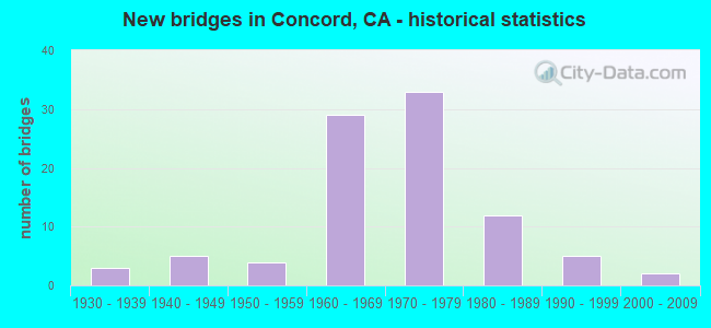
- New bridges - historical statistics
- 31930-1939
- 51940-1949
- 41950-1959
- 291960-1969
- 331970-1979
- 121980-1989
- 51990-1999
- 22000-2009

- Reconstructed bridges - Historical Statistics
- 11940-1949
- 01950-1959
- 11960-1969
- 11970-1979
- 71980-1989
- 11990-1999
- 72000-2009


- Bridge Condition - Deck
- 1.6%Very good
- 45.2%Good
- 11.3%Satisfactory
- 30.6%Fair
- 11.3%Poor

- Bridge Condition - Superstructure
- 61.3%Good
- 17.7%Satisfactory
- 16.1%Fair
- 4.8%Poor

- Bridge Condition - Substructure
- 1.6%Very good
- 79.0%Good
- 4.8%Satisfactory
- 11.3%Fair
- 3.2%Poor

- Bridge Condition - Channel
- 25.6%Excellent
- 46.5%Very good
- 16.3%Good
- 9.3%Satisfactory
- 2.3%Fair

- Bridge Condition - Culverts
- 44.4%Good
- 55.6%Satisfactory
Find on map >> Show street view
Structure Number: TRAC-027, Location: Contra Costa Canal (Lat: 37.965069, Lng: -122.022000), Route carried "on" structure: Other road , Year Built: 1939, Status: Posted for load, Structure Length: 2.50m (8.20ft), Average Daily Traffic: 2 (year 2017), Average Future Daily Traffic: 2 (year 2037), Features Intersected: Galinda Creek, Facility Carried by Structure: Canal Trail
Minimum Vertical Clearance: 30+ m (98+ ft), Kilometerpoint: 52.904, Lanes on structure: 1, Owner: Bureau of Reclamation, Maintenance Responsibility: State Agenciy, Approaching Roadway Width: 4.6m (15.1ft), Material/Design: Wood or Timber, Design/Construction: Stringer/Multi-beam, Number Of Spans In Main Unit: 3, Length of Maximum Span: 8.2m (26.9ft), Curb or Sidewalk Widths: Left: 0.2m (0.7ft), Right: 0.2m (0.7ft), Curb-To-Curb Width: 3.4m (11.2ft), Out-to-Out Width: 3.7m (12.1ft)
Condition: Deck: Very good, Superstructure: Good, Substructure: Very good, Channel: Fair, Operating Rating: 32.0 metric tons, Method Used To Determine Operating Rating: Allowable Stress (AS), Inventory Rating: 22.7 metric tons, Method Used To Determine Inventory Rating: Allowable Stress (AS), Structural Evaluation: Equal to present minimum criteria, Deck Geometry: High priority of corrective action, Waterway Adequacy: Better than present minimum criteria, Approach Roadway Alignment: Better than present minimum criteria, Designated Inspection Frequency: Every 48 months, Inspection Date: January 2021, Deck Structure Type: Wood or Timber
Find on map >> Show street view
Structure Number: 28 0040G, Location: 04-CC-680-R18.70-CND (Lat: 37.958678, Lng: -122.051858), Route carried "on" structure: Ramp State highway 680, Year Built: 1963, Year Reconstructed: 1998, Status: Open, Structure Length: 18.68m (61.29ft), Average Daily Traffic: 20,800 (year 2010), Truck Traffic: 8%, Average Future Daily Traffic: 27,260 (year 2043), Design Load: HS 20+Mod, Features Intersected: WALNUT CREEK
Minimum Vertical Clearance: 30+ m (98+ ft), Kilometerpoint: 18.700, Lanes on structure: 3, Owner: State Highway Agency, Approaching Roadway Width: 15.5m (50.9ft), Skew: 5 degrees, Material/Design: Concrete continuous, Design/Construction: Box Beam or Girders - Multiple, Number Of Spans In Main Unit: 7, Length of Maximum Span: 27.4m (89.9ft), Curb-To-Curb Width: 15.5m (50.9ft), Out-to-Out Width: 16.6m (54.5ft)
Condition: Deck: Poor, Superstructure: Good, Substructure: Fair, Channel: Good, Operating Rating: 43.1 metric tons, Method Used To Determine Operating Rating: Load and Resistance Factor Rating (LRFR) rating reported by rating factor(RF) method using HL-93 loadings, Inventory Rating: 31.1 metric tons, Method Used To Determine Inventory Rating: Load and Resistance Factor Rating (LRFR) rating reported by rating factor(RF) method using HL-93 loadings, Structural Evaluation: Somewhat better than minimum adequacy, Deck Geometry: Superior to present desirable criteria, Waterway Adequacy: Equal to present desirable criteria, Approach Roadway Alignment: Equal to present desirable criteria, Designated Inspection Frequency: Every 24 months, Inspection Date: January 2021, Deck Structure Type: Concrete Cast-file-Place
Find on map >> Show street view
Structure Number: 28 0147, Location: 04-CC-242-R2.65-CND (Lat: 37.995372, Lng: -122.038742), Route carried "on" structure: State highway 242, Year Built: 1978, Year Reconstructed: 2000, Status: Open, Structure Length: 1.55m (5.09ft), Average Daily Traffic: 100,000 (year 2009), Truck Traffic: 5%, Average Future Daily Traffic: 166,507 (year 2042), Design Load: HS 20+Mod, Features Intersected: HOLBROOK CHANNEL
Minimum Vertical Clearance: 30+ m (98+ ft), Kilometerpoint: 2.650, Lanes on structure: 6, Base Highway Network: Yes (Inventory Route: 2, Subroute: 1), Owner: State Highway Agency, Approaching Roadway Width: 54.8m (179.8ft), Skew: 31 degrees, Material/Design: Prestressed concrete, Design/Construction: Slab, Number Of Spans In Main Unit: 1, Length of Maximum Span: 15.2m (49.9ft), Curb-To-Curb Width: 54.8m (179.8ft), Out-to-Out Width: 58.1m (190.6ft)
Condition: Deck: Good, Superstructure: Good, Substructure: Good, Channel: Very good, Operating Rating: 54.1 metric tons, Method Used To Determine Operating Rating: Assigned rating based on Load Factor Design (LFD) reported in metric tons, Inventory Rating: 32.4 metric tons, Method Used To Determine Inventory Rating: Assigned rating based on Load Factor Design (LFD) reported in metric tons, Structural Evaluation: Better than present minimum criteria, Deck Geometry: Superior to present desirable criteria, Waterway Adequacy: Equal to present desirable criteria, Approach Roadway Alignment: Equal to present desirable criteria, Designated Inspection Frequency: Every 48 months, Inspection Date: January 2020, Deck Structure Type: Concrete Cast-file-Place, Wearing Surface/Protective System: Wearing Surface: Bituminous
Find on map >> Show street view
Structure Number: 28 0163, Location: 04-CC-242-R0.87-CND (Lat: 37.970906, Lng: -122.047697), Route carried "on" structure: State highway 242, Year Built: 1963, Year Reconstructed: 2000, Status: Open, Structure Length: 8.02m (26.31ft), Average Daily Traffic: 80,000 (year 2009), Truck Traffic: 5%, Average Future Daily Traffic: 220,846 (year 2044), Design Load: HS 20, Features Intersected: WILLOW PASS ROAD
Minimum Vertical Clearance: 30+ m (98+ ft), Kilometerpoint: 0.870, Lanes on structure: 6, Lanes under structure: 6, Base Highway Network: Yes (Inventory Route: 2, Subroute: 1), Owner: State Highway Agency, Approaching Roadway Width: 33.0m (108.3ft), Skew: 30 degrees, Material/Design: Concrete continuous, Design/Construction: Box Beam or Girders - Multiple, Number Of Spans In Main Unit: 3, Length of Maximum Span: 38.7m (127.0ft), Curb-To-Curb Width: 33.0m (108.3ft), Out-to-Out Width: 34.4m (112.9ft)
Condition: Deck: Fair, Superstructure: Satisfactory, Substructure: Good, Channel: Very good, Operating Rating: 47.6 metric tons, Method Used To Determine Operating Rating: Load and Resistance Factor Rating (LRFR) rating reported by rating factor(RF) method using HL-93 loadings, Inventory Rating: 36.6 metric tons, Method Used To Determine Inventory Rating: Load and Resistance Factor Rating (LRFR) rating reported by rating factor(RF) method using HL-93 loadings, Structural Evaluation: Equal to present minimum criteria, Deck Geometry: Superior to present desirable criteria, Underclear: High priority of corrective action, Waterway Adequacy: Equal to present desirable criteria, Approach Roadway Alignment: Equal to present minimum criteria, Designated Inspection Frequency: Every 24 months, Inspection Date: January 2022, Deck Structure Type: Concrete Cast-file-Place
Find on map >> Show street view
Structure Number: 28 0164Y, Location: 04-CC-242-R0.90-CND (Lat: 37.970769, Lng: -122.047528), Route carried "on" structure: State highway 242, Year Built: 1963, Status: Open, Structure Length: 2.35m (7.71ft), Average Daily Traffic: 22,357 (year 2009), Truck Traffic: 1%, Average Future Daily Traffic: 24,561 (year 2044), Design Load: HS 20, Features Intersected: PINE CREEK, Facility Carried by Structure: WILLOW PASS ROAD
Minimum Vertical Clearance: 4.57m (14.99ft), Kilometerpoint: 0.900, Lanes on structure: 6, Owner: State Highway Agency, Approaching Roadway Width: 19.0m (62.3ft), Skew: 24 degrees, Material/Design: Concrete continuous, Design/Construction: Slab, Number Of Spans In Main Unit: 2, Length of Maximum Span: 11.6m (38.1ft), Curb or Sidewalk Widths: Left: 2.4m (7.9ft), Right: 2.4m (7.9ft), Curb-To-Curb Width: 19.0m (62.3ft), Out-to-Out Width: 25.0m (82.0ft)
Condition: Deck: Good, Superstructure: Good, Substructure: Good, Channel: Very good, Operating Rating: 54.1 metric tons, Method Used To Determine Operating Rating: Load Factor (LF), Inventory Rating: 32.4 metric tons, Method Used To Determine Inventory Rating: Load Factor (LF), Structural Evaluation: Better than present minimum criteria, Deck Geometry: High priority of replacement, Waterway Adequacy: Equal to present desirable criteria, Approach Roadway Alignment: Equal to present desirable criteria, Designated Inspection Frequency: Every 48 months, Inspection Date: January 2022, Deck Structure Type: Concrete Cast-file-Place, Wearing Surface/Protective System: Wearing Surface: Bituminous
Find on map >> Show street view
Structure Number: 28 0165Y, Location: 04-CC-242-R0.85-CND (Lat: 37.970619, Lng: -122.047178), Route carried "on" structure: State highway 242, Year Built: 1964, Status: Open, Structure Length: 2.16m (7.09ft), Average Daily Traffic: 200 (year 2009), Truck Traffic: 2%, Average Future Daily Traffic: 216 (year 2044), Design Load: HS 20, Features Intersected: PINE CREEK, Facility Carried by Structure: PARK & RIDE ACCESS
Minimum Vertical Clearance: 30+ m (98+ ft), Kilometerpoint: 0.850, Lanes on structure: 2, Owner: State Highway Agency, Approaching Roadway Width: 8.5m (27.9ft), Skew: 3 degrees, Material/Design: Concrete, Design/Construction: Tee Beam, Number Of Spans In Main Unit: 1, Length of Maximum Span: 19.8m (65.0ft), Curb or Sidewalk Widths: Left: 0.6m (2.0ft), Right: 0.6m (2.0ft), Curb-To-Curb Width: 8.5m (27.9ft), Out-to-Out Width: 10.3m (33.8ft)
Condition: Deck: Good, Superstructure: Satisfactory, Substructure: Good, Channel: Very good, Operating Rating: 30.8 metric tons, Method Used To Determine Operating Rating: Load and Resistance Factor Rating (LRFR) rating reported by rating factor(RF) method using HL-93 loadings, Inventory Rating: 22.0 metric tons, Method Used To Determine Inventory Rating: Load and Resistance Factor Rating (LRFR) rating reported by rating factor(RF) method using HL-93 loadings, Structural Evaluation: Equal to present minimum criteria, Deck Geometry: Equal to present minimum criteria, Waterway Adequacy: Equal to present desirable criteria, Approach Roadway Alignment: Equal to present minimum criteria, Designated Inspection Frequency: Every 24 months, Inspection Date: January 2022, Deck Structure Type: Concrete Cast-file-Place
Find on map >> Show street view
Structure Number: 28 017, Location: 04-CC-680-22.70 (Lat: 38.010864, Lng: -122.088114), Route carried "on" structure: Interstate 680, Year Built: 1962, Year Reconstructed: 1991, Status: Open, Structure Length: 7.16m (23.49ft), Average Daily Traffic: 105,000 (year 2009), Average Future Daily Traffic: 161,609 (year 2038), Design Load: HS 20+Mod, Features Intersected: ARTHUR ROAD
Minimum Vertical Clearance: 30+ m (98+ ft), Kilometerpoint: 22.700, Lanes on structure: 8, Lanes under structure: 2, Base Highway Network: Yes (Inventory Route: 6, Subroute: 1), Owner: State Highway Agency, Approaching Roadway Width: 17.1m (56.1ft), Skew: 39 degrees, Material/Design: Concrete continuous, Design/Construction: Tee Beam, Number Of Spans In Main Unit: 4, Length of Maximum Span: 28.3m (92.8ft), Curb-To-Curb Width: 34.8m (114.2ft), Out-to-Out Width: 36.6m (120.1ft)
Condition: Deck: Good, Superstructure: Good, Substructure: Good, Operating Rating: 53.5 metric tons, Method Used To Determine Operating Rating: Load Factor (LF), Inventory Rating: 32.1 metric tons, Method Used To Determine Inventory Rating: Load Factor (LF), Structural Evaluation: Better than present minimum criteria, Deck Geometry: Equal to present minimum criteria, Underclear: Better than present minimum criteria, Approach Roadway Alignment: Equal to present desirable criteria, Designated Inspection Frequency: Every 48 months, Inspection Date: January 2021, Deck Structure Type: Concrete Cast-file-Place
Find on map >> Show street view
Structure Number: 28 0178, Location: 04-CC-680-19.04-CND (Lat: 37.966597, Lng: -122.055172), Route carried "on" structure: Interstate 680, Year Built: 1962, Year Reconstructed: 1991, Status: Open, Structure Length: 4.83m (15.85ft), Average Daily Traffic: 130,000 (year 2009), Truck Traffic: 3%, Average Future Daily Traffic: 231,854 (year 2041), Design Load: HS 20+Mod, Features Intersected: WILLOW PASS ROAD
Minimum Vertical Clearance: 30+ m (98+ ft), Kilometerpoint: 19.040, Lanes on structure: 9, Lanes under structure: 7, Base Highway Network: Yes (Inventory Route: 6, Subroute: 1), Owner: State Highway Agency, Approaching Roadway Width: 17.1m (56.1ft), Skew: 31 degrees, Material/Design: Concrete continuous, Design/Construction: Box Beam or Girders - Multiple, Number Of Spans In Main Unit: 3, Length of Maximum Span: 25.8m (84.6ft), Curb-To-Curb Width: 37.1m (121.7ft), Out-to-Out Width: 38.7m (127.0ft)
Condition: Deck: Poor, Superstructure: Good, Substructure: Good, Operating Rating: 54.1 metric tons, Method Used To Determine Operating Rating: Assigned rating based on Load Factor Design (LFD) reported in metric tons, Inventory Rating: 32.4 metric tons, Method Used To Determine Inventory Rating: Assigned rating based on Load Factor Design (LFD) reported in metric tons, Structural Evaluation: Better than present minimum criteria, Deck Geometry: Meets minimum limits, Underclear: High priority of corrective action, Approach Roadway Alignment: Equal to present desirable criteria, Length Of Structure Improvement: 4.83m (15.85ft), Designated Inspection Frequency: Every 24 months, Inspection Date: January 2021, Bridge Improvement Cost: $1,953,000, Roadway Improvement Cost: $390,000, Total Project Cost: $3,281,000 ( Estimate for 2021), Deck Structure Type: Concrete Cast-file-Place
Find on map >> Show street view
Structure Number: 28 0185, Location: 04-CC-242-R1.47-CND (Lat: 37.978778, Lng: -122.043269), Route carried "on" structure: State highway 242, Year Built: 1963, Year Reconstructed: 2000, Status: Open, Structure Length: 4.82m (15.81ft), Average Daily Traffic: 100,000 (year 2009), Truck Traffic: 5%, Average Future Daily Traffic: 164,317 (year 2042), Design Load: HS 20, Features Intersected: CONCORD AVENUE
Minimum Vertical Clearance: 30+ m (98+ ft), Kilometerpoint: 1.470, Lanes on structure: 6, Lanes under structure: 8, Base Highway Network: Yes (Inventory Route: 2, Subroute: 1), Owner: State Highway Agency, Approaching Roadway Width: 33.0m (108.3ft), Skew: 31 degrees, Material/Design: Concrete continuous, Design/Construction: Box Beam or Girders - Multiple, Number Of Spans In Main Unit: 3, Length of Maximum Span: 25.6m (84.0ft), Curb-To-Curb Width: 33.0m (108.3ft), Out-to-Out Width: 34.4m (112.9ft)
Condition: Deck: Poor, Superstructure: Good, Substructure: Good, Operating Rating: 78.0 metric tons, Method Used To Determine Operating Rating: Load Factor (LF), Inventory Rating: 47.1 metric tons, Method Used To Determine Inventory Rating: Load Factor (LF), Structural Evaluation: Better than present minimum criteria, Deck Geometry: Superior to present desirable criteria, Underclear: Meets minimum limits, Approach Roadway Alignment: Equal to present desirable criteria, Length Of Structure Improvement: 4.82m (15.81ft), Designated Inspection Frequency: Every 24 months, Inspection Date: January 2022, Deck Structure Type: Concrete Cast-file-Place
Find on map >> Show street view
Structure Number: 28 0185K, Location: 04-CC-242-R1.40-CND (Lat: 37.978836, Lng: -122.043694), Route carried "on" structure: Ramp State highway 242, Year Built: 1996, Status: Open, Structure Length: 4.50m (14.76ft), Average Daily Traffic: 2,500 (year 2012), Truck Traffic: 5%, Average Future Daily Traffic: 3,316 (year 2042), Design Load: HS 20+Mod, Features Intersected: CONCORD AVENUE
Minimum Vertical Clearance: 30+ m (98+ ft), Kilometerpoint: 1.400, Lanes on structure: 2, Lanes under structure: 8, Owner: State Highway Agency, Approaching Roadway Width: 14.0m (45.9ft), Material/Design: Prestressed concrete continuous, Design/Construction: Stringer/Multi-beam, Number Of Spans In Main Unit: 3, Length of Maximum Span: 25.5m (83.7ft), Curb-To-Curb Width: 14.0m (45.9ft), Out-to-Out Width: 15.0m (49.2ft)
Condition: Deck: Good, Superstructure: Good, Substructure: Good, Operating Rating: 54.1 metric tons, Method Used To Determine Operating Rating: Assigned rating based on Load Factor Design (LFD) reported in metric tons, Inventory Rating: 32.4 metric tons, Method Used To Determine Inventory Rating: Assigned rating based on Load Factor Design (LFD) reported in metric tons, Structural Evaluation: Better than present minimum criteria, Deck Geometry: Superior to present desirable criteria, Underclear: High priority of corrective action, Approach Roadway Alignment: Equal to present minimum criteria, Designated Inspection Frequency: Every 24 months, Inspection Date: January 2022, Deck Structure Type: Concrete Cast-file-Place
Find on map >> Show street view
Structure Number: 28 0185S, Location: 04-CC-242-R1.40-CND (Lat: 37.978697, Lng: -122.043078), Route carried "on" structure: Ramp State highway 242, Year Built: 1996, Status: Open, Structure Length: 4.50m (14.76ft), Average Daily Traffic: 5,200 (year 2012), Truck Traffic: 5%, Average Future Daily Traffic: 6,244 (year 2044), Design Load: HS 20+Mod, Features Intersected: CONCORD AVENUE
Minimum Vertical Clearance: 30+ m (98+ ft), Kilometerpoint: 1.400, Lanes on structure: 2, Lanes under structure: 8, Base Highway Network: Yes, Owner: State Highway Agency, Approaching Roadway Width: 10.9m (35.8ft), Material/Design: Prestressed concrete continuous, Design/Construction: Stringer/Multi-beam, Number Of Spans In Main Unit: 3, Length of Maximum Span: 25.5m (83.7ft), Curb-To-Curb Width: 10.9m (35.8ft), Out-to-Out Width: 11.9m (39.0ft)
Condition: Deck: Fair, Superstructure: Good, Substructure: Good, Operating Rating: 54.1 metric tons, Method Used To Determine Operating Rating: Assigned rating based on Load Factor Design (LFD) reported in metric tons, Inventory Rating: 32.4 metric tons, Method Used To Determine Inventory Rating: Assigned rating based on Load Factor Design (LFD) reported in metric tons, Structural Evaluation: Better than present minimum criteria, Deck Geometry: Better than present minimum criteria, Underclear: High priority of corrective action, Approach Roadway Alignment: Equal to present desirable criteria, Designated Inspection Frequency: Every 24 months, Inspection Date: January 2022, Deck Structure Type: Concrete Cast-file-Place
Find on map >> Show street view
Structure Number: 28 0186, Location: 04-CC-242-R1.61-CND (Lat: 37.980414, Lng: -122.042336), Route carried "on" structure: State highway 242, Year Built: 1963, Year Reconstructed: 2000, Status: Open, Structure Length: 11.34m (37.20ft), Average Daily Traffic: 80,000 (year 2009), Truck Traffic: 5%, Average Future Daily Traffic: 226,050 (year 2044), Design Load: HS 20, Features Intersected: RV STORAGE
Minimum Vertical Clearance: 30+ m (98+ ft), Kilometerpoint: 1.610, Lanes on structure: 6, Base Highway Network: Yes (Inventory Route: 2, Subroute: 1), Owner: State Highway Agency, Approaching Roadway Width: 37.4m (122.7ft), Skew: 34 degrees, Material/Design: Concrete continuous, Design/Construction: Box Beam or Girders - Multiple, Number Of Spans In Main Unit: 4, Length of Maximum Span: 42.7m (140.1ft), Curb-To-Curb Width: 37.4m (122.7ft), Out-to-Out Width: 39.0m (128.0ft)
Condition: Deck: Fair, Superstructure: Good, Substructure: Good, Operating Rating: 54.1 metric tons, Method Used To Determine Operating Rating: Field evaluation and documented engineering judgment, Inventory Rating: 32.4 metric tons, Method Used To Determine Inventory Rating: Field evaluation and documented engineering judgment, Structural Evaluation: Better than present minimum criteria, Deck Geometry: Superior to present desirable criteria, Approach Roadway Alignment: Equal to present desirable criteria, Designated Inspection Frequency: Every 24 months, Inspection Date: January 2022, Deck Structure Type: Concrete Cast-file-Place, Wearing Surface/Protective System: Wearing Surface: Integral Concrete
Find on map >> Show street view
Structure Number: 28 0186K, Location: 04-CC-242-R1.70-CND (Lat: 37.981219, Lng: -122.042458), Route carried "on" structure: Ramp State highway 242, Year Built: 1996, Status: Open, Structure Length: 4.86m (15.94ft), Average Daily Traffic: 18,300 (year 2008), Truck Traffic: 5%, Average Future Daily Traffic: 7,883 (year 2042), Design Load: HS 20+Mod, Features Intersected: RV STORAGE
Minimum Vertical Clearance: 30+ m (98+ ft), Kilometerpoint: 1.700, Lanes on structure: 2, Owner: State Highway Agency, Approaching Roadway Width: 11.0m (36.1ft), Skew: 2 degrees, Material/Design: Prestressed concrete, Design/Construction: Box Beam or Girders - Multiple, Number Of Spans In Main Unit: 1, Length of Maximum Span: 45.6m (149.6ft), Curb-To-Curb Width: 11.0m (36.1ft), Out-to-Out Width: 12.0m (39.4ft)
Condition: Deck: Good, Superstructure: Satisfactory, Substructure: Good, Operating Rating: 54.1 metric tons, Method Used To Determine Operating Rating: Assigned rating based on Load Factor Design (LFD) reported in metric tons, Inventory Rating: 32.4 metric tons, Method Used To Determine Inventory Rating: Assigned rating based on Load Factor Design (LFD) reported in metric tons, Structural Evaluation: Equal to present minimum criteria, Deck Geometry: Better than present minimum criteria, Approach Roadway Alignment: Equal to present desirable criteria, Designated Inspection Frequency: Every 24 months, Inspection Date: January 2022, Deck Structure Type: Concrete Cast-file-Place
Find on map >> Show street view
Structure Number: 28 0201, Location: 04-CC-680-R10.37 (Lat: 37.851369, Lng: -122.028508), Route carried "on" structure: Interstate 680, Year Built: 1964, Year Reconstructed: 1994, Status: Open, Structure Length: 4.48m (14.70ft), Average Daily Traffic: 195,300 (year 2017), Truck Traffic: 6%, Average Future Daily Traffic: 154,000 (year 2038), Design Load: HS 20, Features Intersected: STONE VALLEY ROAD
Minimum Vertical Clearance: 30+ m (98+ ft), Kilometerpoint: 10.370, Lanes on structure: 10, Lanes under structure: 4, Base Highway Network: Yes (Inventory Route: 6, Subroute: 1), Owner: State Highway Agency, Approaching Roadway Width: 54.5m (178.8ft), Skew: 31 degrees, Material/Design: Concrete continuous, Design/Construction: Box Beam or Girders - Multiple, Number Of Spans In Main Unit: 3, Length of Maximum Span: 26.5m (86.9ft), Curb-To-Curb Width: 54.5m (178.8ft), Out-to-Out Width: 55.7m (182.7ft)
Condition: Deck: Fair, Superstructure: Satisfactory, Substructure: Good, Operating Rating: 44.1 metric tons, Method Used To Determine Operating Rating: Load and Resistance Factor Rating (LRFR) rating reported by rating factor(RF) method using HL-93 loadings, Inventory Rating: 30.1 metric tons, Method Used To Determine Inventory Rating: Load and Resistance Factor Rating (LRFR) rating reported by rating factor(RF) method using HL-93 loadings, Structural Evaluation: Equal to present minimum criteria, Deck Geometry: Superior to present desirable criteria, Underclear: Meets minimum limits, Approach Roadway Alignment: Equal to present desirable criteria, Designated Inspection Frequency: Every 24 months, Inspection Date: July 2020, Deck Structure Type: Concrete Cast-file-Place
Find on map >> Show street view
Structure Number: 28 0209, Location: 04-CC-242-R2.15-CND (Lat: 37.988064, Lng: -122.040333), Route carried "on" structure: State highway 242, Year Built: 1963, Year Reconstructed: 2000, Status: Open, Structure Length: 7.50m (24.61ft), Average Daily Traffic: 80,000 (year 2009), Truck Traffic: 5%, Average Future Daily Traffic: 227,561 (year 2044), Features Intersected: SOLANO WAY
Minimum Vertical Clearance: 6.71m (22.01ft), Kilometerpoint: 2.150, Lanes on structure: 7, Lanes under structure: 5, Base Highway Network: Yes (Inventory Route: 2, Subroute: 1), Owner: State Highway Agency, Approaching Roadway Width: 37.2m (122.0ft), Skew: 34 degrees, Material/Design: Concrete continuous, Design/Construction: Box Beam or Girders - Multiple, Number Of Spans In Main Unit: 4, Length of Maximum Span: 22.6m (74.1ft), Curb-To-Curb Width: 37.2m (122.0ft), Out-to-Out Width: 38.7m (127.0ft)
Condition: Deck: Satisfactory, Superstructure: Good, Substructure: Good, Operating Rating: 54.1 metric tons, Method Used To Determine Operating Rating: Field evaluation and documented engineering judgment, Inventory Rating: 32.4 metric tons, Method Used To Determine Inventory Rating: Field evaluation and documented engineering judgment, Structural Evaluation: Better than present minimum criteria, Deck Geometry: Superior to present desirable criteria, Underclear: Equal to present minimum criteria, Approach Roadway Alignment: Equal to present desirable criteria, Designated Inspection Frequency: Every 48 months, Inspection Date: January 2022, Deck Structure Type: Concrete Cast-file-Place
Find on map >> Show street view
Structure Number: 28 0238L, Location: 04-CC-004-R16.00-CND (Lat: 38.011339, Lng: -122.012931), Route carried "on" structure: State highway 4, Year Built: 1975, Status: Open, Structure Length: 20.48m (67.19ft), Average Daily Traffic: 73,000 (year 2017), Truck Traffic: 7%, Average Future Daily Traffic: 95,947 (year 2039), Design Load: HS 20, Features Intersected: USN RR & KINNE BLVD
Minimum Vertical Clearance: 30+ m (98+ ft), Kilometerpoint: 16.000, Lanes on structure: 4, Base Highway Network: Yes (, Subroute: 1), Owner: State Highway Agency, Approaching Roadway Width: 18.9m (62.0ft), Skew: 4 degrees, Material/Design: Prestressed concrete continuous, Design/Construction: Box Beam or Girders - Multiple, Number Of Spans In Main Unit: 4, Length of Maximum Span: 62.9m (206.4ft), Curb-To-Curb Width: 19.0m (62.3ft), Out-to-Out Width: 20.1m (65.9ft)
Condition: Deck: Good, Superstructure: Good, Substructure: Good, Operating Rating: 60.3 metric tons, Method Used To Determine Operating Rating: Load and Resistance Factor Rating (LRFR) rating reported by rating factor(RF) method using HL-93 loadings, Inventory Rating: 46.3 metric tons, Method Used To Determine Inventory Rating: Load and Resistance Factor Rating (LRFR) rating reported by rating factor(RF) method using HL-93 loadings, Structural Evaluation: Better than present minimum criteria, Deck Geometry: Meets minimum limits, Underclear: Somewhat better than minimum adequacy, Approach Roadway Alignment: Equal to present desirable criteria, Designated Inspection Frequency: Every 24 months, Inspection Date: May 2021, Deck Structure Type: Concrete Cast-file-Place
Find on map >> Show street view
Structure Number: 28 0238R, Location: 04-CC-004-R16.00-CND (Lat: 38.010986, Lng: -122.012331), Route carried "on" structure: State highway 4, Year Built: 1976, Status: Open, Structure Length: 20.48m (67.19ft), Average Daily Traffic: 73,000 (year 2017), Truck Traffic: 7%, Average Future Daily Traffic: 95,947 (year 2039), Design Load: HS 20, Features Intersected: USN RR & KINNE BLVD
Minimum Vertical Clearance: 30+ m (98+ ft), Kilometerpoint: 16.000, Lanes on structure: 4, Base Highway Network: Yes (, Subroute: 1), Owner: State Highway Agency, Approaching Roadway Width: 18.9m (62.0ft), Skew: 4 degrees, Material/Design: Prestressed concrete continuous, Design/Construction: Box Beam or Girders - Multiple, Number Of Spans In Main Unit: 4, Length of Maximum Span: 61.6m (202.1ft), Curb-To-Curb Width: 19.0m (62.3ft), Out-to-Out Width: 20.1m (65.9ft)
Condition: Deck: Good, Superstructure: Good, Substructure: Good, Operating Rating: 76.8 metric tons, Method Used To Determine Operating Rating: Load and Resistance Factor Rating (LRFR) rating reported by rating factor(RF) method using HL-93 loadings, Inventory Rating: 56.7 metric tons, Method Used To Determine Inventory Rating: Load and Resistance Factor Rating (LRFR) rating reported by rating factor(RF) method using HL-93 loadings, Structural Evaluation: Better than present minimum criteria, Deck Geometry: Meets minimum limits, Underclear: Superior to present desirable criteria, Approach Roadway Alignment: Equal to present desirable criteria, Designated Inspection Frequency: Every 24 months, Inspection Date: May 2021, Deck Structure Type: Concrete Cast-file-Place
Find on map >> Show street view
Structure Number: 28 0240L, Location: 04-CC-004-R13.40 (Lat: 37.999806, Lng: -122.057719), Route carried "on" structure: State highway 4, Year Built: 1981, Status: Open, Structure Length: 12.98m (42.59ft), Average Daily Traffic: 31,000 (year 2018), Truck Traffic: 7%, Average Future Daily Traffic: 63,819 (year 2042), Design Load: HS 20+Mod, Features Intersected: WALNUT CREEK
Minimum Vertical Clearance: 30+ m (98+ ft), Kilometerpoint: 13.400, Lanes on structure: 2, Base Highway Network: Yes (, Subroute: 1), Owner: State Highway Agency, Approaching Roadway Width: 11.7m (38.4ft), Material/Design: Concrete continuous, Design/Construction: Box Beam or Girders - Multiple, Number Of Spans In Main Unit: 5, Length of Maximum Span: 27.4m (89.9ft), Curb-To-Curb Width: 11.7m (38.4ft), Out-to-Out Width: 12.7m (41.7ft)
Condition: Deck: Good, Superstructure: Good, Substructure: Good, Channel: Very good, Operating Rating: 54.1 metric tons, Method Used To Determine Operating Rating: Assigned rating based on Load Factor Design (LFD) reported in metric tons, Inventory Rating: 32.4 metric tons, Method Used To Determine Inventory Rating: Assigned rating based on Load Factor Design (LFD) reported in metric tons, Structural Evaluation: Better than present minimum criteria, Deck Geometry: Equal to present minimum criteria, Waterway Adequacy: Equal to present desirable criteria, Approach Roadway Alignment: Equal to present desirable criteria, Designated Inspection Frequency: Every 24 months, Inspection Date: June 2020, Deck Structure Type: Concrete Cast-file-Place
Find on map >> Show street view
Structure Number: 28 0241L, Location: 04-CC-004-R13.65 (Lat: 38.001008, Lng: -122.053472), Route carried "on" structure: State highway 4, Year Built: 1981, Status: Open, Structure Length: 8.63m (28.31ft), Average Daily Traffic: 31,000 (year 2018), Truck Traffic: 7%, Average Future Daily Traffic: 63,819 (year 2042), Design Load: HS 20+Mod, Features Intersected: SOLANO WAY
Minimum Vertical Clearance: 30+ m (98+ ft), Kilometerpoint: 13.650, Lanes on structure: 3, Lanes under structure: 5, Base Highway Network: Yes (, Subroute: 1), Owner: State Highway Agency, Approaching Roadway Width: 14.9m (48.9ft), Material/Design: Prestressed concrete continuous, Design/Construction: Box Beam or Girders - Multiple, Number Of Spans In Main Unit: 4, Length of Maximum Span: 25.9m (85.0ft), Curb-To-Curb Width: 14.9m (48.9ft), Out-to-Out Width: 16.0m (52.5ft)
Condition: Deck: Good, Superstructure: Good, Substructure: Good, Operating Rating: 54.1 metric tons, Method Used To Determine Operating Rating: Assigned rating based on Load Factor Design (LFD) reported in metric tons, Inventory Rating: 32.4 metric tons, Method Used To Determine Inventory Rating: Assigned rating based on Load Factor Design (LFD) reported in metric tons, Structural Evaluation: Better than present minimum criteria, Deck Geometry: Meets minimum limits, Underclear: Somewhat better than minimum adequacy, Approach Roadway Alignment: Equal to present desirable criteria, Designated Inspection Frequency: Every 24 months, Inspection Date: June 2020, Deck Structure Type: Concrete Cast-file-Place
Find on map >> Show street view
Structure Number: 28 0241R, Location: 04-CC-004-R13.65 (Lat: 38.000664, Lng: -122.053378), Route carried "on" structure: State highway 4, Year Built: 1981, Status: Open, Structure Length: 8.59m (28.18ft), Average Daily Traffic: 31,000 (year 2018), Truck Traffic: 7%, Average Future Daily Traffic: 63,819 (year 2042), Design Load: HS 20+Mod, Features Intersected: SOLANO WAY
Minimum Vertical Clearance: 30+ m (98+ ft), Kilometerpoint: 13.650, Lanes on structure: 3, Lanes under structure: 5, Base Highway Network: Yes (, Subroute: 1), Owner: State Highway Agency, Approaching Roadway Width: 16.1m (52.8ft), Skew: 9 degrees, Material/Design: Prestressed concrete continuous, Design/Construction: Box Beam or Girders - Multiple, Number Of Spans In Main Unit: 4, Length of Maximum Span: 25.9m (85.0ft), Curb-To-Curb Width: 16.1m (52.8ft), Out-to-Out Width: 17.2m (56.4ft)
Condition: Deck: Good, Superstructure: Good, Substructure: Good, Operating Rating: 54.1 metric tons, Method Used To Determine Operating Rating: Assigned rating based on Load Factor Design (LFD) reported in metric tons, Inventory Rating: 32.4 metric tons, Method Used To Determine Inventory Rating: Assigned rating based on Load Factor Design (LFD) reported in metric tons, Structural Evaluation: Better than present minimum criteria, Deck Geometry: Equal to present minimum criteria, Underclear: Somewhat better than minimum adequacy, Approach Roadway Alignment: Equal to present desirable criteria, Designated Inspection Frequency: Every 24 months, Inspection Date: June 2020, Deck Structure Type: Concrete Cast-file-Place
Find on map >> Show street view
Structure Number: 28 0242L, Location: 04-CC-004-R13.96-CND (Lat: 38.002381, Lng: -122.047942), Route carried "on" structure: State highway 4, Year Built: 1981, Status: Open, Structure Length: 5.38m (17.65ft), Average Daily Traffic: 31,000 (year 2018), Truck Traffic: 7%, Average Future Daily Traffic: 63,819 (year 2042), Design Load: HS 20+Mod, Features Intersected: PERALTA ROAD
Minimum Vertical Clearance: 30+ m (98+ ft), Kilometerpoint: 13.960, Lanes on structure: 3, Lanes under structure: 5, Base Highway Network: Yes (, Subroute: 1), Owner: State Highway Agency, Approaching Roadway Width: 15.8m (51.8ft), Skew: 9 degrees, Material/Design: Prestressed concrete, Design/Construction: Box Beam or Girders - Multiple, Number Of Spans In Main Unit: 1, Length of Maximum Span: 53.8m (176.5ft), Curb-To-Curb Width: 15.3m (50.2ft), Out-to-Out Width: 16.4m (53.8ft)
Condition: Deck: Good, Superstructure: Good, Substructure: Good, Operating Rating: 54.1 metric tons, Method Used To Determine Operating Rating: Assigned rating based on Load Factor Design (LFD) reported in metric tons, Inventory Rating: 32.4 metric tons, Method Used To Determine Inventory Rating: Assigned rating based on Load Factor Design (LFD) reported in metric tons, Structural Evaluation: Better than present minimum criteria, Deck Geometry: Meets minimum limits, Underclear: Somewhat better than minimum adequacy, Approach Roadway Alignment: Equal to present desirable criteria, Designated Inspection Frequency: Every 24 months, Inspection Date: June 2020, Deck Structure Type: Concrete Cast-file-Place
Find on map >> Show street view
Structure Number: 28 0242R, Location: 04-CC-004-R13.96-CND (Lat: 38.002019, Lng: -122.047936), Route carried "on" structure: State highway 4, Year Built: 1978, Status: Open, Structure Length: 5.67m (18.60ft), Average Daily Traffic: 31,000 (year 2018), Truck Traffic: 7%, Average Future Daily Traffic: 63,819 (year 2042), Design Load: HS 20, Features Intersected: PERALTA ROAD
Minimum Vertical Clearance: 30+ m (98+ ft), Kilometerpoint: 13.960, Lanes on structure: 3, Lanes under structure: 5, Base Highway Network: Yes (, Subroute: 1), Owner: State Highway Agency, Approaching Roadway Width: 18.6m (61.0ft), Skew: 21 degrees, Material/Design: Prestressed concrete, Design/Construction: Box Beam or Girders - Multiple, Number Of Spans In Main Unit: 1, Length of Maximum Span: 56.7m (186.0ft), Curb-To-Curb Width: 18.6m (61.0ft), Out-to-Out Width: 19.7m (64.6ft)
Condition: Deck: Good, Superstructure: Good, Substructure: Good, Operating Rating: 54.1 metric tons, Method Used To Determine Operating Rating: Assigned rating based on Load Factor Design (LFD) reported in metric tons, Inventory Rating: 32.4 metric tons, Method Used To Determine Inventory Rating: Assigned rating based on Load Factor Design (LFD) reported in metric tons, Structural Evaluation: Better than present minimum criteria, Deck Geometry: Superior to present desirable criteria, Underclear: Equal to present minimum criteria, Approach Roadway Alignment: Equal to present desirable criteria, Designated Inspection Frequency: Every 24 months, Inspection Date: June 2020, Deck Structure Type: Concrete Cast-file-Place
Find on map >> Show street view
Structure Number: 28 0243L, Location: 04-CC-004-R14.64-CND (Lat: 38.005819, Lng: -122.036561), Route carried "on" structure: State highway 4, Year Built: 1978, Status: Open, Structure Length: 13.66m (44.82ft), Average Daily Traffic: 31,000 (year 2018), Truck Traffic: 7%, Average Future Daily Traffic: 62,350 (year 2042), Design Load: HS 20+Mod, Features Intersected: W4-S242 CONNECTOR RAMP
Minimum Vertical Clearance: 30+ m (98+ ft), Kilometerpoint: 14.640, Lanes on structure: 2, Lanes under structure: 3, Base Highway Network: Yes (, Subroute: 1), Owner: State Highway Agency, Approaching Roadway Width: 15.3m (50.2ft), Skew: 6 degrees, Material/Design: Prestressed concrete continuous, Design/Construction: Box Beam or Girders - Multiple, Number Of Spans In Main Unit: 3, Length of Maximum Span: 66.6m (218.5ft), Curb-To-Curb Width: 15.3m (50.2ft), Out-to-Out Width: 16.4m (53.8ft)
Condition: Deck: Good, Superstructure: Good, Substructure: Good, Operating Rating: 54.1 metric tons, Method Used To Determine Operating Rating: Assigned rating based on Load Factor Design (LFD) reported in metric tons, Inventory Rating: 32.4 metric tons, Method Used To Determine Inventory Rating: Assigned rating based on Load Factor Design (LFD) reported in metric tons, Structural Evaluation: Better than present minimum criteria, Deck Geometry: Superior to present desirable criteria, Underclear: Equal to present minimum criteria, Approach Roadway Alignment: Equal to present desirable criteria, Designated Inspection Frequency: Every 24 months, Inspection Date: June 2020, Deck Structure Type: Concrete Cast-file-Place
Find on map >> Show street view
Structure Number: 28 0243R, Location: 04-CC-004-R14.62-CND (Lat: 38.005342, Lng: -122.036900), Route carried "on" structure: State highway 4, Year Built: 1978, Status: Open, Structure Length: 11.90m (39.04ft), Average Daily Traffic: 31,000 (year 2018), Truck Traffic: 7%, Average Future Daily Traffic: 63,819 (year 2042), Design Load: HS 20+Mod, Features Intersected: W4-S242 CONNECTOR RAMP
Minimum Vertical Clearance: 30+ m (98+ ft), Kilometerpoint: 14.620, Lanes on structure: 2, Lanes under structure: 3, Base Highway Network: Yes (, Subroute: 1), Owner: State Highway Agency, Approaching Roadway Width: 11.9m (39.0ft), Skew: 6 degrees, Material/Design: Prestressed concrete continuous, Design/Construction: Box Beam or Girders - Multiple, Number Of Spans In Main Unit: 3, Length of Maximum Span: 55.5m (182.1ft), Curb-To-Curb Width: 15.3m (50.2ft), Out-to-Out Width: 16.4m (53.8ft)
Condition: Deck: Good, Superstructure: Good, Substructure: Good, Operating Rating: 54.1 metric tons, Method Used To Determine Operating Rating: Assigned rating based on Load Factor Design (LFD) reported in metric tons, Inventory Rating: 32.4 metric tons, Method Used To Determine Inventory Rating: Assigned rating based on Load Factor Design (LFD) reported in metric tons, Structural Evaluation: Better than present minimum criteria, Deck Geometry: Superior to present desirable criteria, Underclear: Equal to present minimum criteria, Approach Roadway Alignment: Equal to present desirable criteria, Designated Inspection Frequency: Every 24 months, Inspection Date: June 2020, Deck Structure Type: Concrete Cast-file-Place
Find on map >> Show street view
Structure Number: 28 0243S, Location: 04-CC-004-R14.61-CND (Lat: 38.005178, Lng: -122.036956), Route carried "on" structure: Ramp State highway 4, Year Built: 1978, Status: Open, Structure Length: 20.33m (66.70ft), Average Daily Traffic: 4,800 (year 2018), Truck Traffic: 8%, Average Future Daily Traffic: 12,735 (year 2042), Design Load: HS 20+Mod, Features Intersected: W4-S242 & N242-E4 CONNS
Minimum Vertical Clearance: 30+ m (98+ ft), Kilometerpoint: 14.610, Lanes on structure: 1, Lanes under structure: 6, Owner: State Highway Agency, Approaching Roadway Width: 7.3m (24.0ft), Skew: 3 degrees, Material/Design: Prestressed concrete continuous, Design/Construction: Box Beam or Girders - Multiple, Number Of Spans In Main Unit: 4, Length of Maximum Span: 55.7m (182.7ft), Curb-To-Curb Width: 7.3m (24.0ft), Out-to-Out Width: 8.4m (27.6ft)
Condition: Deck: Good, Superstructure: Good, Substructure: Good, Operating Rating: 54.1 metric tons, Method Used To Determine Operating Rating: Assigned rating based on Load Factor Design (LFD) reported in metric tons, Inventory Rating: 32.4 metric tons, Method Used To Determine Inventory Rating: Assigned rating based on Load Factor Design (LFD) reported in metric tons, Structural Evaluation: Better than present minimum criteria, Deck Geometry: Better than present minimum criteria, Underclear: Equal to present minimum criteria, Approach Roadway Alignment: Equal to present desirable criteria, Designated Inspection Frequency: Every 24 months, Inspection Date: June 2020, Deck Structure Type: Concrete Cast-file-Place
Find on map >> Show street view
Structure Number: 28 0244L, Location: 04-CC-004-R15.42-CND (Lat: 38.009764, Lng: -122.023183), Route carried "on" structure: State highway 4, Year Built: 1976, Status: Open, Structure Length: 6.92m (22.70ft), Average Daily Traffic: 73,000 (year 2017), Truck Traffic: 7%, Average Future Daily Traffic: 95,947 (year 2039), Design Load: HS 20, Features Intersected: PORT CHICAGO HWY
Minimum Vertical Clearance: 30+ m (98+ ft), Kilometerpoint: 15.420, Lanes on structure: 5, Lanes under structure: 5, Base Highway Network: Yes (, Subroute: 1), Owner: State Highway Agency, Approaching Roadway Width: 22.6m (74.1ft), Skew: 20 degrees, Material/Design: Prestressed concrete, Design/Construction: Box Beam or Girders - Multiple, Number Of Spans In Main Unit: 1, Number Of Approach Spans: 2, Length of Maximum Span: 57.6m (189.0ft), Curb-To-Curb Width: 22.6m (74.1ft), Out-to-Out Width: 23.7m (77.8ft)
Condition: Deck: Satisfactory, Superstructure: Good, Substructure: Good, Operating Rating: 87.8 metric tons, Method Used To Determine Operating Rating: Load Factor (LF), Inventory Rating: 32.4 metric tons, Method Used To Determine Inventory Rating: Load Factor (LF), Structural Evaluation: Better than present minimum criteria, Deck Geometry: Meets minimum limits, Underclear: Somewhat better than minimum adequacy, Approach Roadway Alignment: Equal to present desirable criteria, Designated Inspection Frequency: Every 24 months, Inspection Date: May 2021, Deck Structure Type: Concrete Cast-file-Place
Find on map >> Show street view
Structure Number: 28 0244R, Location: 04-CC-004-R15.42-CND (Lat: 38.009189, Lng: -122.022967), Route carried "on" structure: State highway 4, Year Built: 1976, Status: Open, Structure Length: 5.91m (19.39ft), Average Daily Traffic: 73,000 (year 2017), Truck Traffic: 7%, Average Future Daily Traffic: 95,947 (year 2039), Design Load: HS 20, Features Intersected: PORT CHICAGO HWY
Minimum Vertical Clearance: 30+ m (98+ ft), Kilometerpoint: 15.420, Lanes on structure: 7, Lanes under structure: 4, Base Highway Network: Yes (, Subroute: 1), Owner: State Highway Agency, Approaching Roadway Width: 33.8m (110.9ft), Skew: 30 degrees, Material/Design: Prestressed concrete, Design/Construction: Box Beam or Girders - Multiple, Number Of Spans In Main Unit: 1, Length of Maximum Span: 58.8m (192.9ft), Curb-To-Curb Width: 33.8m (110.9ft), Out-to-Out Width: 38.3m (125.7ft)
Condition: Deck: Fair, Superstructure: Good, Substructure: Good, Operating Rating: 73.9 metric tons, Method Used To Determine Operating Rating: Load and Resistance Factor Rating (LRFR) rating reported by rating factor(RF) method using HL-93 loadings, Inventory Rating: 43.1 metric tons, Method Used To Determine Inventory Rating: Load and Resistance Factor Rating (LRFR) rating reported by rating factor(RF) method using HL-93 loadings, Structural Evaluation: Better than present minimum criteria, Deck Geometry: Superior to present desirable criteria, Underclear: Somewhat better than minimum adequacy, Approach Roadway Alignment: Equal to present desirable criteria, Designated Inspection Frequency: Every 24 months, Inspection Date: May 2021, Deck Structure Type: Concrete Cast-file-Place
Find on map >> Show street view
Structure Number: 28 0248, Location: 04-CC-242-R2.79-CND (Lat: 37.997564, Lng: -122.039233), Route carried "on" structure: City street , Year Built: 1978, Status: Open, Structure Length: 9.72m (31.89ft), Average Daily Traffic: 17,400 (year 2009), Truck Traffic: 2%, Average Future Daily Traffic: 25,996 (year 2042), Design Load: HS 20, Features Intersected: STATE ROUTE 242, Facility Carried by Structure: OLIVERA ROAD
Minimum Vertical Clearance: 30+ m (98+ ft), Kilometerpoint: 0.000, Lanes on structure: 4, Lanes under structure: 8, Owner: State Highway Agency, Approaching Roadway Width: 19.2m (63.0ft), Skew: 21 degrees, Material/Design: Prestressed concrete continuous, Design/Construction: Box Beam or Girders - Multiple, Number Of Spans In Main Unit: 3, Length of Maximum Span: 38.4m (126.0ft), Curb or Sidewalk Widths: Left: 1.5m (4.9ft), Right: 1.5m (4.9ft), Curb-To-Curb Width: 19.2m (63.0ft), Out-to-Out Width: 23.1m (75.8ft)
Condition: Deck: Fair, Superstructure: Fair, Substructure: Good, Operating Rating: 54.1 metric tons, Method Used To Determine Operating Rating: Assigned rating based on Load Factor Design (LFD) reported in metric tons, Inventory Rating: 32.4 metric tons, Method Used To Determine Inventory Rating: Assigned rating based on Load Factor Design (LFD) reported in metric tons, Structural Evaluation: Somewhat better than minimum adequacy, Deck Geometry: Equal to present minimum criteria, Underclear: Somewhat better than minimum adequacy, Approach Roadway Alignment: Better than present minimum criteria, Designated Inspection Frequency: Every 24 months, Inspection Date: January 2022, Deck Structure Type: Concrete Cast-file-Place
Find on map >> Show street view
Structure Number: 28 0249G, Location: 04-CC-242-R3.24-CND (Lat: 38.003903, Lng: -122.036536), Route carried "on" structure: Ramp State highway 242, Year Built: 1978, Status: Open, Structure Length: 43.25m (141.90ft), Average Daily Traffic: 8,300 (year 2012), Truck Traffic: 7%, Average Future Daily Traffic: 9,182 (year 2042), Design Load: HS 20, Features Intersected: STATE ROUTES 4 & 242
Minimum Vertical Clearance: 30+ m (98+ ft), Kilometerpoint: 3.240, Lanes on structure: 1, Lanes under structure: 18, Owner: State Highway Agency, Approaching Roadway Width: 8.2m (26.9ft), Material/Design: Prestressed concrete continuous, Design/Construction: Box Beam or Girders - Multiple, Number Of Spans In Main Unit: 9, Length of Maximum Span: 55.2m (181.1ft), Curb-To-Curb Width: 8.0m (26.2ft), Out-to-Out Width: 9.0m (29.5ft)
Condition: Deck: Poor, Superstructure: Fair, Substructure: Good, Operating Rating: 54.1 metric tons, Method Used To Determine Operating Rating: Assigned rating based on Load Factor Design (LFD) reported in metric tons, Inventory Rating: 32.4 metric tons, Method Used To Determine Inventory Rating: Assigned rating based on Load Factor Design (LFD) reported in metric tons, Structural Evaluation: Somewhat better than minimum adequacy, Deck Geometry: Superior to present desirable criteria, Underclear: Equal to present minimum criteria, Approach Roadway Alignment: Equal to present minimum criteria, Designated Inspection Frequency: Every 24 months, Inspection Date: January 2022, Deck Structure Type: Concrete Cast-file-Place
Find on map >> Show street view
Structure Number: 28 026, Location: 04-CC-004-R14.45-CND (Lat: 38.004250, Lng: -122.039378), Route carried "on" structure: State highway 4, Year Built: 1978, Status: Open, Structure Length: 0.73m (2.40ft), Average Daily Traffic: 62,000 (year 2018), Truck Traffic: 7%, Average Future Daily Traffic: 127,639 (year 2042), Design Load: HS 20+Mod, Features Intersected: EBMUD SERVICE ROAD
Minimum Vertical Clearance: 30+ m (98+ ft), Kilometerpoint: 14.450, Lanes on structure: 4, Base Highway Network: Yes (, Subroute: 1), Owner: State Highway Agency, Approaching Roadway Width: 28.0m (91.9ft), Skew: 20 degrees, Material/Design: Concrete, Design/Construction: Slab, Number Of Spans In Main Unit: 1, Length of Maximum Span: 7.3m (24.0ft), Curb-To-Curb Width: 28.0m (91.9ft), Out-to-Out Width: 45.6m (149.6ft)
Condition: Deck: Fair, Superstructure: Fair, Substructure: Good, Operating Rating: 99.8 metric tons, Method Used To Determine Operating Rating: Load Factor (LF), Inventory Rating: 99.8 metric tons, Method Used To Determine Inventory Rating: Load Factor (LF), Structural Evaluation: Somewhat better than minimum adequacy, Deck Geometry: Superior to present desirable criteria, Approach Roadway Alignment: Equal to present desirable criteria, Designated Inspection Frequency: Every 24 months, Inspection Date: June 2020, Deck Structure Type: Concrete Cast-file-Place
Find on map >> Show street view
Structure Number: 28 0260G, Location: 04-CC-004-R14.45-CND (Lat: 38.004011, Lng: -122.039294), Route carried "on" structure: Ramp State highway 4, Year Built: 1978, Status: Open, Structure Length: 0.88m (2.89ft), Average Daily Traffic: 7,500 (year 2018), Truck Traffic: 6%, Average Future Daily Traffic: 22,400 (year 2042), Design Load: HS 20+Mod, Features Intersected: EBMUD SERVICE ROAD
Minimum Vertical Clearance: 30+ m (98+ ft), Kilometerpoint: 14.450, Lanes on structure: 1, Owner: State Highway Agency, Approaching Roadway Width: 8.2m (26.9ft), Material/Design: Concrete, Design/Construction: Slab, Number Of Spans In Main Unit: 1, Length of Maximum Span: 7.9m (25.9ft), Curb-To-Curb Width: 8.2m (26.9ft), Out-to-Out Width: 9.3m (30.5ft)
Condition: Deck: Fair, Superstructure: Fair, Substructure: Good, Operating Rating: 54.1 metric tons, Method Used To Determine Operating Rating: Assigned rating based on Load Factor Design (LFD) reported in metric tons, Inventory Rating: 32.4 metric tons, Method Used To Determine Inventory Rating: Assigned rating based on Load Factor Design (LFD) reported in metric tons, Structural Evaluation: Somewhat better than minimum adequacy, Deck Geometry: Superior to present desirable criteria, Approach Roadway Alignment: Equal to present minimum criteria, Designated Inspection Frequency: Every 24 months, Inspection Date: June 2020, Deck Structure Type: Concrete Cast-file-Place
Find on map >> Show street view
Structure Number: 28 0261Y, Location: 04-CC-242-R2.80-CND (Lat: 37.997758, Lng: -122.040158), Route carried "on" structure: State highway 242, Year Built: 1978, Status: Open, Structure Length: 0.73m (2.40ft), Average Daily Traffic: 24,360 (year 2011), Truck Traffic: 5%, Average Future Daily Traffic: 31,326 (year 2042), Design Load: HS 20+Mod, Features Intersected: EBMUD SERVICE ROAD, Facility Carried by Structure: OLIVERA ROAD
Minimum Vertical Clearance: 30+ m (98+ ft), Kilometerpoint: 2.800, Lanes on structure: 4, Lanes under structure: 1, Owner: State Highway Agency, Maintenance Responsibility: City or Municipal Highway Agency, Approaching Roadway Width: 18.3m (60.0ft), Skew: 20 degrees, Material/Design: Concrete, Design/Construction: Slab, Number Of Spans In Main Unit: 1, Length of Maximum Span: 6.1m (20.0ft), Curb or Sidewalk Widths: Left: 2.6m (8.5ft), Right: 2.6m (8.5ft), Curb-To-Curb Width: 17.0m (55.8ft), Out-to-Out Width: 24.1m (79.1ft)
Condition: Deck: Fair, Superstructure: Satisfactory, Substructure: Satisfactory, Operating Rating: 67.7 metric tons, Method Used To Determine Operating Rating: Load Factor (LF), Inventory Rating: 40.5 metric tons, Method Used To Determine Inventory Rating: Load Factor (LF), Structural Evaluation: Equal to present minimum criteria, Deck Geometry: Somewhat better than minimum adequacy, Approach Roadway Alignment: Better than present minimum criteria, Length Of Structure Improvement: 0.73m (2.40ft), Designated Inspection Frequency: Every 24 months, Inspection Date: January 2022, Bridge Improvement Cost: $178,000, Roadway Improvement Cost: $35,000, Total Project Cost: $299,000 ( Estimate for 2018), Deck Structure Type: Concrete Cast-file-Place
Find on map >> Show street view
Structure Number: 28 0268K, Location: 04-CC-242-R2.77-CND (Lat: 37.997344, Lng: -122.039347), Route carried "on" structure: Ramp State highway 242, Year Built: 1978, Status: Open, Structure Length: 0.73m (2.40ft), Average Daily Traffic: 6,300 (year 2009), Truck Traffic: 2%, Average Future Daily Traffic: 9,563 (year 2044), Design Load: HS 20+Mod, Features Intersected: EBMUD SERVICE ROAD
Minimum Vertical Clearance: 30+ m (98+ ft), Kilometerpoint: 2.770, Lanes on structure: 1, Lanes under structure: 1, Owner: State Highway Agency, Approaching Roadway Width: 7.3m (24.0ft), Material/Design: Concrete, Design/Construction: Slab, Number Of Spans In Main Unit: 1, Length of Maximum Span: 6.1m (20.0ft), Curb-To-Curb Width: 7.3m (24.0ft), Out-to-Out Width: 7.9m (25.9ft)
Condition: Deck: Fair, Superstructure: Fair, Substructure: Satisfactory, Operating Rating: 80.7 metric tons, Method Used To Determine Operating Rating: Load Factor (LF), Inventory Rating: 48.3 metric tons, Method Used To Determine Inventory Rating: Load Factor (LF), Structural Evaluation: Somewhat better than minimum adequacy, Deck Geometry: Better than present minimum criteria, Approach Roadway Alignment: Equal to present minimum criteria, Designated Inspection Frequency: Every 24 months, Inspection Date: January 2022, Deck Structure Type: Concrete Cast-file-Place
Find on map >> Show street view
Structure Number: 28 0281L, Location: 04-CC-080-5.99-RCH (Lat: 37.976353, Lng: -122.318872), Route carried "on" structure: City street , Year Built: 1977, Status: Open, Structure Length: 8.72m (28.61ft), Average Daily Traffic: 32,500 (year 2019), Truck Traffic: 1%, Average Future Daily Traffic: 32,712 (year 2041), Design Load: HS 20+Mod, Features Intersected: INTERSTATE 80, Facility Carried by Structure: HILLTOP DRIVE WB
Minimum Vertical Clearance: 30+ m (98+ ft), Kilometerpoint: 0.000, Lanes on structure: 2, Lanes under structure: 10, Owner: State Highway Agency, Approaching Roadway Width: 9.8m (32.2ft), Material/Design: Prestressed concrete continuous, Design/Construction: Box Beam or Girders - Multiple, Number Of Spans In Main Unit: 2, Length of Maximum Span: 45.7m (149.9ft), Curb or Sidewalk Widths: Left: 1.5m (4.9ft), Right: 0.0m, Curb-To-Curb Width: 11.0m (36.1ft), Out-to-Out Width: 13.4m (44.0ft)
Condition: Deck: Good, Superstructure: Fair, Substructure: Fair, Operating Rating: 54.1 metric tons, Method Used To Determine Operating Rating: Assigned rating based on Load Factor Design (LFD) reported in metric tons, Inventory Rating: 32.4 metric tons, Method Used To Determine Inventory Rating: Assigned rating based on Load Factor Design (LFD) reported in metric tons, Structural Evaluation: Somewhat better than minimum adequacy, Deck Geometry: Equal to present minimum criteria, Underclear: High priority of corrective action, Approach Roadway Alignment: Better than present minimum criteria, Designated Inspection Frequency: Every 24 months, Inspection Date: July 2021, Deck Structure Type: Concrete Cast-file-Place
Find on map >> Show street view
Structure Number: 28 0289, Location: 04-CC-242-R0.78-CND (Lat: 37.969531, Lng: -122.047836), Route carried "on" structure: State highway 242, Year Built: 1986, Year Reconstructed: 2000, Status: Open, Structure Length: 5.06m (16.60ft), Average Daily Traffic: 80,000 (year 2009), Truck Traffic: 5%, Average Future Daily Traffic: 230,609 (year 2044), Design Load: HS 20+Mod, Features Intersected: CLAYTON ROAD-S242 ON RMP
Minimum Vertical Clearance: 30+ m (98+ ft), Kilometerpoint: 0.780, Lanes on structure: 6, Lanes under structure: 2, Base Highway Network: Yes (Inventory Route: 2, Subroute: 1), Owner: State Highway Agency, Approaching Roadway Width: 33.0m (108.3ft), Skew: 32 degrees, Material/Design: Prestressed concrete continuous, Design/Construction: Box Beam or Girders - Multiple, Number Of Spans In Main Unit: 2, Length of Maximum Span: 29.6m (97.1ft), Curb-To-Curb Width: 33.0m (108.3ft), Out-to-Out Width: 34.6m (113.5ft)
Condition: Deck: Satisfactory, Superstructure: Good, Substructure: Good, Operating Rating: 54.1 metric tons, Method Used To Determine Operating Rating: Assigned rating based on Load Factor Design (LFD) reported in metric tons, Inventory Rating: 32.4 metric tons, Method Used To Determine Inventory Rating: Assigned rating based on Load Factor Design (LFD) reported in metric tons, Structural Evaluation: Better than present minimum criteria, Deck Geometry: Superior to present desirable criteria, Underclear: Meets minimum limits, Approach Roadway Alignment: Equal to present desirable criteria, Designated Inspection Frequency: Every 48 months, Inspection Date: January 2022, Deck Structure Type: Concrete Cast-file-Place
Find on map >> Show street view
Structure Number: 28C0039, Location: AT CLAYTON ST (Lat: 37.969922, Lng: -122.046469), Route carried "on" structure: City street , Year Built: 1972, Status: Open, Structure Length: 2.13m (6.99ft), Average Daily Traffic: 16,169 (year 1975), Truck Traffic: 5%, Average Future Daily Traffic: 29,335 (year 2037), Design Load: HS 20, Features Intersected: PINE CREEK, Facility Carried by Structure: MARKET ST
Minimum Vertical Clearance: 30+ m (98+ ft), Kilometerpoint: 0.000, Lanes on structure: 4, Base Highway Network: Yes, Owner: City or Municipal Highway Agency, Approaching Roadway Width: 18.4m (60.4ft), Skew: 2 degrees, Material/Design: Prestressed concrete, Design/Construction: Box Beam or Girders - Multiple, Number Of Spans In Main Unit: 1, Length of Maximum Span: 20.9m (68.6ft), Curb or Sidewalk Widths: Left: 1.8m (5.9ft), Right: 1.8m (5.9ft), Curb-To-Curb Width: 18.4m (60.4ft), Out-to-Out Width: 22.6m (74.1ft)
Condition: Deck: Good, Superstructure: Good, Substructure: Good, Channel: Very good, Operating Rating: 68.0 metric tons, Method Used To Determine Operating Rating: Load Factor (LF), Inventory Rating: 32.4 metric tons, Method Used To Determine Inventory Rating: Load Factor (LF), Structural Evaluation: Better than present minimum criteria, Deck Geometry: Somewhat better than minimum adequacy, Waterway Adequacy: Equal to present desirable criteria, Approach Roadway Alignment: Equal to present minimum criteria, Designated Inspection Frequency: Every 48 months, Inspection Date: January 2019, Deck Structure Type: Concrete Precast Panels, Wearing Surface/Protective System: Wearing Surface: Bituminous
Find on map >> Show street view
Structure Number: 28C0091L, Location: 0.83 MI E SH 680 (Lat: 37.980719, Lng: -122.052314), Route carried "on" structure: City street , Year Built: 1964, Status: Open, Structure Length: 11.59m (38.02ft), Average Daily Traffic: 17,732 (year 1978), Truck Traffic: 7%, Average Future Daily Traffic: 28,954 (year 2041), Design Load: HS 20, Features Intersected: WALNUT CREEK, Facility Carried by Structure: CONCORD AVE
Minimum Vertical Clearance: 30+ m (98+ ft), Kilometerpoint: 0.000, Lanes on structure: 3, Base Highway Network: Yes, Owner: City or Municipal Highway Agency, Approaching Roadway Width: 10.4m (34.1ft), Material/Design: Prestressed concrete continuous, Design/Construction: Stringer/Multi-beam, Number Of Spans In Main Unit: 5, Length of Maximum Span: 23.1m (75.8ft), Curb or Sidewalk Widths: Left: 1.5m (4.9ft), Right: 0.6m (2.0ft), Curb-To-Curb Width: 10.4m (34.1ft), Out-to-Out Width: 13.1m (43.0ft)
Condition: Deck: Fair, Superstructure: Satisfactory, Substructure: Good, Channel: Excellent, Operating Rating: 29.8 metric tons, Method Used To Determine Operating Rating: Load and Resistance Factor Rating (LRFR) rating reported by rating factor(RF) method using HL-93 loadings, Inventory Rating: 20.4 metric tons, Method Used To Determine Inventory Rating: Load and Resistance Factor Rating (LRFR) rating reported by rating factor(RF) method using HL-93 loadings, Structural Evaluation: Somewhat better than minimum adequacy, Deck Geometry: High priority of replacement, Waterway Adequacy: Equal to present desirable criteria, Approach Roadway Alignment: Equal to present minimum criteria, Designated Inspection Frequency: Every 24 months, Inspection Date: January 2021, Deck Structure Type: Concrete Cast-file-Place, Wearing Surface/Protective System: Wearing Surface: Integral Concrete
Find on map >> Show street view
Structure Number: 28C0091R, Location: 0.83 MI E SH 680 (Lat: 37.980572, Lng: -122.052344), Route carried "on" structure: City street , Year Built: 1964, Year Reconstructed: 1983, Status: Open, Structure Length: 11.58m (37.99ft), Average Daily Traffic: 18,144 (year 1978), Truck Traffic: 7%, Average Future Daily Traffic: 30,027 (year 2041), Design Load: HS 20, Features Intersected: WALNUT CREEK, Facility Carried by Structure: CONCORD AVE
Minimum Vertical Clearance: 30+ m (98+ ft), Kilometerpoint: 0.000, Lanes on structure: 3, Base Highway Network: Yes, Owner: City or Municipal Highway Agency, Approaching Roadway Width: 10.4m (34.1ft), Material/Design: Prestressed concrete continuous, Design/Construction: Stringer/Multi-beam, Number Of Spans In Main Unit: 5, Length of Maximum Span: 23.1m (75.8ft), Curb or Sidewalk Widths: Left: 0.6m (2.0ft), Right: 1.5m (4.9ft), Curb-To-Curb Width: 10.4m (34.1ft), Out-to-Out Width: 13.1m (43.0ft)
Condition: Deck: Fair, Superstructure: Satisfactory, Substructure: Good, Channel: Good, Operating Rating: 29.2 metric tons, Method Used To Determine Operating Rating: Load and Resistance Factor Rating (LRFR) rating reported by rating factor(RF) method using HL-93 loadings, Inventory Rating: 19.8 metric tons, Method Used To Determine Inventory Rating: Load and Resistance Factor Rating (LRFR) rating reported by rating factor(RF) method using HL-93 loadings, Structural Evaluation: Somewhat better than minimum adequacy, Deck Geometry: High priority of replacement, Waterway Adequacy: Equal to present desirable criteria, Approach Roadway Alignment: Equal to present minimum criteria, Designated Inspection Frequency: Every 24 months, Inspection Date: January 2021, Deck Structure Type: Concrete Cast-file-Place, Wearing Surface/Protective System: Wearing Surface: Integral Concrete
Find on map >> Show street view
Structure Number: 28C0095, Location: 0.2 MI NE OAK GROVE RD (Lat: 37.958494, Lng: -122.035689), Route carried "on" structure: City street , Year Built: 1940, Year Reconstructed: 1953, Status: Open, Structure Length: 0.88m (2.89ft), Average Daily Traffic: 32,500 (year 1979), Truck Traffic: 5%, Average Future Daily Traffic: 51,303 (year 2038), Features Intersected: PINE CREEK, Facility Carried by Structure: MONUMENT BLVD
Minimum Vertical Clearance: 30+ m (98+ ft), Kilometerpoint: 0.000, Lanes on structure: 7, Base Highway Network: Yes, Owner: City or Municipal Highway Agency, Approaching Roadway Width: 23.8m (78.1ft), Skew: 30 degrees, Material/Design: Concrete continuous, Design/Construction: Slab, Number Of Spans In Main Unit: 2, Length of Maximum Span: 4.1m (13.5ft), Curb or Sidewalk Widths: Left: 1.8m (5.9ft), Right: 1.5m (4.9ft), Curb-To-Curb Width: 23.8m (78.1ft), Out-to-Out Width: 29.8m (97.8ft)
Condition: Deck: Good, Superstructure: Good, Substructure: Fair, Channel: Very good, Operating Rating: 26.9 metric tons, Method Used To Determine Operating Rating: Field evaluation and documented engineering judgment, Inventory Rating: 16.2 metric tons, Method Used To Determine Inventory Rating: Field evaluation and documented engineering judgment, Structural Evaluation: Meets minimum limits, Deck Geometry: High priority of replacement, Waterway Adequacy: Equal to present desirable criteria, Approach Roadway Alignment: Better than present minimum criteria, Designated Inspection Frequency: Every 24 months, Inspection Date: November 2021, Deck Structure Type: Concrete Cast-file-Place, Wearing Surface/Protective System: Wearing Surface: Bituminous
Find on map >> Show street view
Structure Number: 28C011, Location: 0.2 MI NE CONCORD BLVD (Lat: 37.971694, Lng: -121.970019), Route carried "on" structure: County highway , Year Built: 2003, Status: Open, Structure Length: 1.31m (4.30ft), Average Daily Traffic: 5,858 (year 2013), Truck Traffic: 5%, Average Future Daily Traffic: 13,620 (year 2038), Design Load: HS 20+Mod, Features Intersected: MOUNT DIABLO CREEK, Facility Carried by Structure: BAILEY ROAD
Minimum Vertical Clearance: 30+ m (98+ ft), Kilometerpoint: 0.000, Lanes on structure: 2, Owner: County Highway Agency, Approaching Roadway Width: 9.9m (32.5ft), Material/Design: Concrete, Design/Construction: Slab, Number Of Spans In Main Unit: 1, Length of Maximum Span: 12.3m (40.4ft), Curb or Sidewalk Widths: Left: 0.0m, Right: 1.2m (3.9ft), Curb-To-Curb Width: 9.9m (32.5ft), Out-to-Out Width: 11.8m (38.7ft)
Condition: Deck: Fair, Superstructure: Fair, Substructure: Good, Channel: Very good, Operating Rating: 54.1 metric tons, Method Used To Determine Operating Rating: Assigned rating based on Load Factor Design (LFD) reported in metric tons, Inventory Rating: 32.4 metric tons, Method Used To Determine Inventory Rating: Assigned rating based on Load Factor Design (LFD) reported in metric tons, Structural Evaluation: Somewhat better than minimum adequacy, Deck Geometry: Meets minimum limits, Waterway Adequacy: Equal to present minimum criteria, Approach Roadway Alignment: Equal to present desirable criteria, Designated Inspection Frequency: Every 24 months, Inspection Date: November 2021, Deck Structure Type: Concrete Cast-file-Place