Bridge Statistics for Coos Bay, Oregon (OR)
Condition, Traffic, Stress, Structural Evaluation, Project Costs
- National Bridge Inventory (NBI) Statistics
- 12Number of bridges
- 302ft / 92.4mTotal length
- $6,558,000Total costs
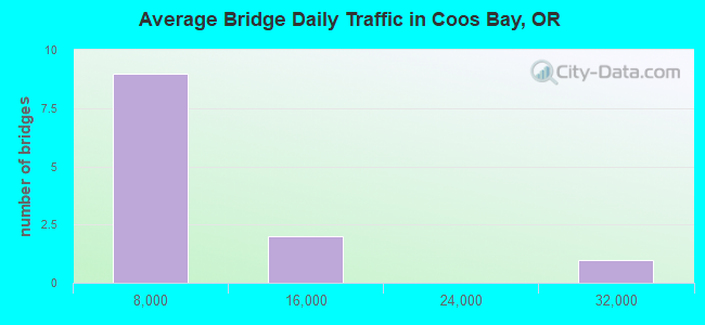
- 52,735Total average daily traffic
- 6,190Total average daily truck traffic
- National Bridge Inventory (NBI) Registered Bridges for Coos Bay
- No street view available for this location
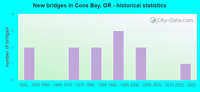
- New bridges - historical statistics
- 21950-1959
- 21970-1979
- 21980-1989
- 31990-1999
- 22000-2009
- 12020-2022
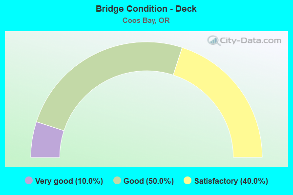
- Bridge Condition - Deck
- 10.0%Very good
- 50.0%Good
- 40.0%Satisfactory
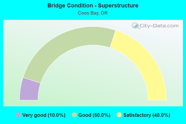
- Bridge Condition - Superstructure
- 10.0%Very good
- 50.0%Good
- 40.0%Satisfactory

- Bridge Condition - Substructure
- 10.0%Very good
- 30.0%Good
- 30.0%Satisfactory
- 30.0%Fair
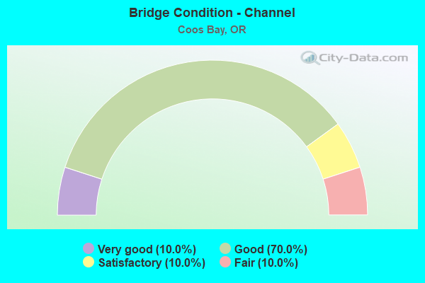
- Bridge Condition - Channel
- 10.0%Very good
- 70.0%Good
- 10.0%Satisfactory
- 10.0%Fair
Find on map >> Show street view
Structure Number: P01155T0001, Location: 2.5 KM EAST OF BARVIEW (Lat: 43.352069, Lng: -124.281369), Route carried "on" structure: Federal lands road 1230, Year Built: 2004, Status: Open, Structure Length: 2.81m (9.22ft), Average Daily Traffic: 10 (year 2021), Truck Traffic: 10%, Average Future Daily Traffic: 60 (year 2040), Design Load: HS 20, Features Intersected: 4TH CREEK, Facility Carried by Structure: UPPER 4TH CREEK RD
Minimum Vertical Clearance: 99.00m (324.80ft), Kilometerpoint: 0.900, Lanes on structure: 1, Owner: Indian Tribal Government, Approaching Roadway Width: 3.7m (12.1ft), Material/Design: Steel, Design/Construction: Girder and Floorbeam System, Number Of Spans In Main Unit: 3, Length of Maximum Span: 20.1m (65.9ft), Curb-To-Curb Width: 5.3m (17.4ft), Out-to-Out Width: 5.5m (18.0ft)
Condition: Deck: Good, Superstructure: Good, Substructure: Good, Channel: Good, Operating Rating: 27.8 metric tons, Method Used To Determine Operating Rating: Load Factor (LF), Inventory Rating: 16.7 metric tons, Method Used To Determine Inventory Rating: Load Factor (LF), Structural Evaluation: Somewhat better than minimum adequacy, Deck Geometry: High priority of corrective action, Waterway Adequacy: Better than present minimum criteria, Approach Roadway Alignment: Equal to present minimum criteria, Bridge Posting: Required (Relationship of Operating Rating to Maximum Legal Load: 10.0 - 19.9% below), Designated Inspection Frequency: Every 24 months, Critical Feature Inspection Frequency: Every 24 months, Inspection Date: October 2021, Deck Structure Type: Steel plate
Find on map >> Show street view
Structure Number: P01155T0002, Location: 2 KM EAST OF BARVIEW (Lat: 43.354833, Lng: -124.285956), Route carried "on" structure: Federal lands road 1200, Year Built: 2004, Status: Open, Structure Length: 2.81m (9.22ft), Average Daily Traffic: 25 (year 2021), Truck Traffic: 10%, Average Future Daily Traffic: 60 (year 2040), Design Load: HS 20, Features Intersected: 4TH CREEK, Facility Carried by Structure: LOWER 4TH CREEK RD
Minimum Vertical Clearance: 99.00m (324.80ft), Kilometerpoint: 1.300, Lanes on structure: 2, Owner: Indian Tribal Government, Approaching Roadway Width: 3.7m (12.1ft), Material/Design: Steel, Design/Construction: Girder and Floorbeam System, Number Of Spans In Main Unit: 3, Length of Maximum Span: 20.1m (65.9ft), Curb-To-Curb Width: 10.8m (35.4ft), Out-to-Out Width: 11.0m (36.1ft)
Condition: Deck: Good, Superstructure: Good, Substructure: Satisfactory, Channel: Good, Operating Rating: 26.8 metric tons, Method Used To Determine Operating Rating: Load Factor (LF), Inventory Rating: 16.0 metric tons, Method Used To Determine Inventory Rating: Load Factor (LF), Structural Evaluation: Meets minimum limits, Deck Geometry: Superior to present desirable criteria, Waterway Adequacy: Better than present minimum criteria, Approach Roadway Alignment: Equal to present minimum criteria, Bridge Posting: Required (Relationship of Operating Rating to Maximum Legal Load: 10.0 - 19.9% below), Designated Inspection Frequency: Every 24 months, Critical Feature Inspection Frequency: Every 24 months, Inspection Date: October 2021, Deck Structure Type: Steel plate
Find on map >> Show street view
Structure Number: 2278E241 00223, Location: 02.23 MI E JCT HWY 009 (Lat: 43.362889, Lng: -124.175861), Route carried "on" structure: State highway 241, Year Built: 1995, Status: Open, Structure Length: 39.01m (127.99ft), Average Daily Traffic: 2,962 (year 2020), Truck Traffic: 18%, Average Future Daily Traffic: 3,400 (year 2040), Design Load: HS 25 or greater, Features Intersected: CATCHING SLOUGH
Minimum Vertical Clearance: 30+ m (98+ ft), Kilometerpoint: 3.524, Lanes on structure: 2, Lanes under structure: 2, Owner: State Highway Agency, Approaching Roadway Width: 12.2m (40.0ft), Navigation Control: Yes ( Vertical Clearance: 12.2m (40.0ft), Horizontal Clearance: 28.0m (91.9ft)), Material/Design: Prestressed concrete continuous, Design/Construction: Stringer/Multi-beam, Number Of Spans In Main Unit: 11, Length of Maximum Span: 36.0m (118.1ft), Curb-To-Curb Width: 12.2m (40.0ft), Out-to-Out Width: 13.0m (42.7ft)
Condition: Deck: Good, Superstructure: Good, Substructure: Good, Channel: Very good, Operating Rating: 25.9 metric tons, Method Used To Determine Operating Rating: Load and Resistance Factor Rating (LRFR) rating reported by rating factor(RF) method using HL-93 loadings, Inventory Rating: 20.1 metric tons, Method Used To Determine Inventory Rating: Load and Resistance Factor Rating (LRFR) rating reported by rating factor(RF) method using HL-93 loadings, Structural Evaluation: Somewhat better than minimum adequacy, Deck Geometry: Equal to present minimum criteria, Underclear: Meets minimum limits, Waterway Adequacy: Superior to present desirable criteria, Approach Roadway Alignment: Equal to present desirable criteria, Length Of Structure Improvement: 39.00m (127.95ft), Designated Inspection Frequency: Every 24 months, Underwater Inspection Frequency: Every 36 months, Inspection Date: Febuary 2020, Underwater Inspection Date: August 2020, Bridge Improvement Cost: $4,099,000, Roadway Improvement Cost: $410,000, Total Project Cost: $6,558,000, Deck Structure Type: Concrete Cast-file-Place, Wearing Surface/Protective System: Wearing Surface: Monolithic Concrete, Deck Protection: Epoxy Coated Reinforcing
Find on map >> Show street view
Structure Number: 2478C009 2392, Location: 03.8 MI S HWY 240 JCT (Lat: 43.356058, Lng: -124.209414), Route carried "on" structure: US 101, Year Built: 1987, Status: Open, Structure Length: 11.03m (36.19ft), Average Daily Traffic: 24,464 (year 2020), Truck Traffic: 11%, Average Future Daily Traffic: 32,600 (year 2040), Design Load: HS 25 or greater, Features Intersected: COALBANK SLOUGH
Minimum Vertical Clearance: 30+ m (98+ ft), Kilometerpoint: 384.955, Lanes on structure: 4, Base Highway Network: Yes, Owner: State Highway Agency, Approaching Roadway Width: 21.9m (71.9ft), Navigation Control: Yes ( Vertical Clearance: 6.1m (20.0ft), Horizontal Clearance: 20.7m (67.9ft)), Material/Design: Concrete continuous, Design/Construction: Slab, Number Of Spans In Main Unit: 6, Length of Maximum Span: 21.3m (69.9ft), Curb or Sidewalk Widths: Left: 1.8m (5.9ft), Right: 1.8m (5.9ft), Curb-To-Curb Width: 21.9m (71.9ft), Out-to-Out Width: 26.6m (87.3ft)
Condition: Deck: Satisfactory, Superstructure: Satisfactory, Substructure: Satisfactory, Channel: Good, Operating Rating: 40.8 metric tons, Method Used To Determine Operating Rating: Load and Resistance Factor Rating (LRFR) rating reported by rating factor(RF) method using HL-93 loadings, Inventory Rating: 31.4 metric tons, Method Used To Determine Inventory Rating: Load and Resistance Factor Rating (LRFR) rating reported by rating factor(RF) method using HL-93 loadings, Structural Evaluation: Equal to present minimum criteria, Deck Geometry: Superior to present desirable criteria, Waterway Adequacy: Superior to present desirable criteria, Approach Roadway Alignment: Equal to present desirable criteria, Designated Inspection Frequency: Every 24 months, Underwater Inspection Frequency: Every 60 months, Inspection Date: May 2021, Underwater Inspection Date: August 2020, Deck Structure Type: Concrete Cast-file-Place, Wearing Surface/Protective System: Wearing Surface: Monolithic Concrete, Deck Protection: Epoxy Coated Reinforcing
Find on map >> Show street view
Structure Number: 7176 241 00373, Location: 01.5 MI E EASTSIDE ECL (Lat: 43.365981, Lng: -124.153011), Route carried "on" structure: State highway 241, Year Built: 1952, Status: Open, Structure Length: 29.43m (96.56ft), Average Daily Traffic: 779 (year 2020), Truck Traffic: 18%, Average Future Daily Traffic: 880 (year 2040), Design Load: HS 15, Features Intersected: COOS RIVER (CHANDLER)
Minimum Vertical Clearance: 4.62m (15.16ft), Kilometerpoint: 6.003, Lanes on structure: 2, Lanes under structure: 2, Owner: State Highway Agency, Approaching Roadway Width: 7.9m (25.9ft), Navigation Control: Yes ( Vertical Clearance: 16.8m (55.1ft), Horizontal Clearance: 18.6m (61.0ft)), Material/Design: Steel, Design/Construction: Movable - Lift, Number Of Spans In Main Unit: 1, Number Of Approach Spans: 14, Length of Maximum Span: 61.0m (200.1ft), Curb-To-Curb Width: 7.9m (25.9ft), Out-to-Out Width: 9.1m (29.9ft)
Condition: Deck: Satisfactory, Superstructure: Satisfactory, Substructure: Fair, Channel: Good, Operating Rating: 17.2 metric tons, Method Used To Determine Operating Rating: Load and Resistance Factor Rating (LRFR) rating reported by rating factor(RF) method using HL-93 loadings, Inventory Rating: 13.3 metric tons, Method Used To Determine Inventory Rating: Load and Resistance Factor Rating (LRFR) rating reported by rating factor(RF) method using HL-93 loadings, Structural Evaluation: Meets minimum limits, Deck Geometry: Somewhat better than minimum adequacy, Waterway Adequacy: Equal to present desirable criteria, Approach Roadway Alignment: Equal to present minimum criteria, Designated Inspection Frequency: Every 24 months, Critical Feature Inspection Frequency: Every 24 months, Underwater Inspection Frequency: Every 36 months, Inspection Date: August 2021, Critical Feature Inspection Date: August 2021, Underwater Inspection Date: September 2021, Deck Structure Type: Closed Grating
Find on map >> Show street view
Structure Number: 11C35B02020002, Location: 0.75 MI E OF CO RD 45 (Lat: 43.401236, Lng: -124.180306), Route carried "on" structure: Spur County highway C202G, Year Built: 1980, Status: Open, Structure Length: 0.91m (2.99ft), Average Daily Traffic: 145 (year 2020), Truck Traffic: 5%, Average Future Daily Traffic: 165 (year 2025), Design Load: H 20, Features Intersected: RUSSELL/WILLANCH CREEK, Facility Carried by Structure: COUNTY RD 202G
Minimum Vertical Clearance: 30+ m (98+ ft), Kilometerpoint: 0.322, Lanes on structure: 2, Owner: County Highway Agency, Approaching Roadway Width: 4.3m (14.1ft), Material/Design: Prestressed concrete, Design/Construction: Slab, Number Of Spans In Main Unit: 1, Length of Maximum Span: 8.5m (27.9ft), Curb-To-Curb Width: 7.1m (23.3ft), Out-to-Out Width: 7.3m (24.0ft)
Condition: Deck: Good, Superstructure: Good, Substructure: Fair, Channel: Satisfactory, Operating Rating: 88.9 metric tons, Method Used To Determine Operating Rating: Allowable Stress (AS), Inventory Rating: 54.4 metric tons, Method Used To Determine Inventory Rating: Allowable Stress (AS), Structural Evaluation: Somewhat better than minimum adequacy, Deck Geometry: Meets minimum limits, Waterway Adequacy: Equal to present desirable criteria, Approach Roadway Alignment: Equal to present minimum criteria, Designated Inspection Frequency: Every 24 months, Inspection Date: September 2020, Deck Structure Type: Other
Find on map >> Show street view
Structure Number: 18029 020500002, Location: 010 MI S ON 205 FROM COOS (Lat: 43.349339, Lng: -124.174131), Route carried "on" structure: Spur County highway C0205, Year Built: 1997, Status: Open, Structure Length: 2.38m (7.81ft), Average Daily Traffic: 355 (year 2020), Truck Traffic: 10%, Average Future Daily Traffic: 400 (year 2025), Design Load: HS 25 or greater, Features Intersected: ROSS-SLOUGH, Facility Carried by Structure: COUNTY RD 205
Minimum Vertical Clearance: 30+ m (98+ ft), Kilometerpoint: 0.032, Lanes on structure: 2, Owner: County Highway Agency, Approaching Roadway Width: 7.3m (24.0ft), Skew: 3 degrees, Material/Design: Prestressed concrete, Design/Construction: Stringer/Multi-beam, Number Of Spans In Main Unit: 1, Length of Maximum Span: 23.2m (76.1ft), Curb-To-Curb Width: 7.3m (24.0ft), Out-to-Out Width: 8.1m (26.6ft)
Condition: Deck: Good, Superstructure: Good, Substructure: Good, Channel: Good, Operating Rating: 89.8 metric tons, Method Used To Determine Operating Rating: Load Factor (LF), Inventory Rating: 54.4 metric tons, Method Used To Determine Inventory Rating: Load Factor (LF), Structural Evaluation: Better than present minimum criteria, Deck Geometry: Somewhat better than minimum adequacy, Waterway Adequacy: Equal to present desirable criteria, Approach Roadway Alignment: Equal to present minimum criteria, Designated Inspection Frequency: Every 24 months, Inspection Date: July 2020, Deck Structure Type: Other, Wearing Surface/Protective System: Wearing Surface: Bituminous
Find on map >> Show street view
Structure Number: 24074 241 0009, Location: MP 0.90 (Lat: 43.361275, Lng: -124.193358), Route carried "on" structure: State highway 241, Year Built: 2021, Status: Open, Structure Length: 0.91m (2.99ft), Average Daily Traffic: 10,640 (year 2020), Truck Traffic: 18%, Average Future Daily Traffic: 17,500 (year 2040), Design Load: HL 93, Features Intersected: Unnamed Creek
Minimum Vertical Clearance: 30+ m (98+ ft), Kilometerpoint: 1.448, Lanes on structure: 2, Owner: State Highway Agency, Approaching Roadway Width: 9.1m (29.9ft), Material/Design: Prestressed concrete, Design/Construction: Slab, Number Of Spans In Main Unit: 1, Length of Maximum Span: 9.1m (29.9ft), Curb or Sidewalk Widths: Left: 1.5m (4.9ft), Right: 1.5m (4.9ft), Curb-To-Curb Width: 9.1m (29.9ft), Out-to-Out Width: 12.2m (40.0ft)
Condition: Deck: Very good, Superstructure: Very good, Substructure: Very good, Channel: Good, Operating Rating: 68.0 metric tons, Method Used To Determine Operating Rating: No rating analysis performed, Inventory Rating: 40.8 metric tons, Method Used To Determine Inventory Rating: No rating analysis performed, Structural Evaluation: Equal to present desirable criteria, Deck Geometry: High priority of corrective action, Waterway Adequacy: Equal to present desirable criteria, Approach Roadway Alignment: Equal to present desirable criteria, Designated Inspection Frequency: Every 24 months, Inspection Date: August 2021, Deck Structure Type: Other, Wearing Surface/Protective System: Wearing Surface: Bituminous
Find on map >> Show street view
Structure Number: C1109 000600019, Location: 0.19 MILES FROM STATE HIG (Lat: 43.365819, Lng: -124.152117), Route carried "on" structure: County highway A432, Year Built: 1977, Status: Open, Structure Length: 1.83m (6.00ft), Average Daily Traffic: 2,127 (year 2020), Truck Traffic: 10%, Average Future Daily Traffic: 2,407 (year 2025), Design Load: HS 20, Features Intersected: LILLIAN CREEK, Facility Carried by Structure: COUNTY RD 6
Minimum Vertical Clearance: 30+ m (98+ ft), Kilometerpoint: 0.306, Lanes on structure: 2, Owner: County Highway Agency, Approaching Roadway Width: 7.9m (25.9ft), Material/Design: Prestressed concrete, Design/Construction: Slab, Number Of Spans In Main Unit: 1, Length of Maximum Span: 17.7m (58.1ft), Curb-To-Curb Width: 7.9m (25.9ft), Out-to-Out Width: 8.5m (27.9ft)
Condition: Deck: Satisfactory, Superstructure: Satisfactory, Substructure: Satisfactory, Channel: Good, Operating Rating: 64.4 metric tons, Method Used To Determine Operating Rating: Load Factor (LF), Inventory Rating: 38.1 metric tons, Method Used To Determine Inventory Rating: Load Factor (LF), Structural Evaluation: Equal to present minimum criteria, Deck Geometry: High priority of corrective action, Waterway Adequacy: Equal to present desirable criteria, Approach Roadway Alignment: Equal to present desirable criteria, Designated Inspection Frequency: Every 24 months, Underwater Inspection Frequency: Every 60 months, Inspection Date: September 2020, Underwater Inspection Date: September 2021, Deck Structure Type: Other, Wearing Surface/Protective System: Wearing Surface: Bituminous
Find on map >> Show street view
Structure Number: C1110 004500458, Location: 02 SOUTH KENTUCKGOLF COUR (Lat: 43.401547, Lng: -124.190883), Route carried "on" structure: County highway A433, Year Built: 1978, Status: Open, Structure Length: 1.28m (4.20ft), Average Daily Traffic: 1,028 (year 2020), Truck Traffic: 10%, Average Future Daily Traffic: 1,163 (year 2025), Design Load: HS 20, Features Intersected: WILLANCH SLOUGH, Facility Carried by Structure: COUNTY RD 45
Minimum Vertical Clearance: 30+ m (98+ ft), Kilometerpoint: 7.371, Lanes on structure: 2, Owner: County Highway Agency, Approaching Roadway Width: 7.3m (24.0ft), Material/Design: Prestressed concrete, Design/Construction: Slab, Number Of Spans In Main Unit: 1, Length of Maximum Span: 11.6m (38.1ft), Curb-To-Curb Width: 9.1m (29.9ft), Out-to-Out Width: 9.8m (32.2ft)
Condition: Deck: Satisfactory, Superstructure: Satisfactory, Substructure: Fair, Channel: Fair, Operating Rating: 37.2 metric tons, Method Used To Determine Operating Rating: Load Factor (LF), Inventory Rating: 22.7 metric tons, Method Used To Determine Inventory Rating: Load Factor (LF), Structural Evaluation: Somewhat better than minimum adequacy, Deck Geometry: Somewhat better than minimum adequacy, Waterway Adequacy: Equal to present desirable criteria, Approach Roadway Alignment: Equal to present minimum criteria, Designated Inspection Frequency: Every 24 months, Inspection Date: September 2020, Deck Structure Type: Other, Wearing Surface/Protective System: Wearing Surface: Bituminous
Find on map >> Show street view
Structure Number: 2278E241 00223, Location: 02.23 MI E JCT HWY 009 (Lat: 43.362889, Lng: -124.175861), Route carried "under" structure: County highway , Year Built: 1995, Structure Length: 0. m, Average Daily Traffic: 8,100 (year 2010), Truck Traffic: 5%, Features Intersected: CATCHING SLOUGH, Facility Carried by Structure: HWY 241
Minimum Vertical Clearance: 5.18m (16.99ft), Kilometerpoint: 0.000, Lanes on structure: 2, Lanes under structure: 2, Material/Design: Prestressed concrete continuous, Design/Construction: Stringer/Multi-beam, Length of Maximum Span: 36.0m (118.1ft)
Find on map >> Show street view
Structure Number: 7176 241 00373, Location: 01.5 MI E EASTSIDE ECL (Lat: 43.365981, Lng: -124.153011), Route carried "under" structure: County highway , Year Built: 1952, Structure Length: 0. m, Average Daily Traffic: 2,100 (year 2010), Truck Traffic: 7%, Features Intersected: COOS RIVER (CHANDLER), Facility Carried by Structure: HWY 241
Minimum Vertical Clearance: 4.57m (14.99ft), Kilometerpoint: 0.000, Lanes on structure: 2, Lanes under structure: 2, Material/Design: Steel, Design/Construction: Movable - Lift, Length of Maximum Span: 61.0m (200.1ft)